1. INTRODUCTION
Currently, there is increasing demand for satellite navigation applications in urban environments and the general requirements are: accuracy between 1 and 10 metres and availability at least 90%. Although Global Positioning System (GPS) has been playing a very important role for several decades in both surveying and navigation, its performance is particularly poor in urban terrestrial environments. The number of visible satellites is not enough to perform the positioning function [Kozlov et al., Reference Kozlov and Tkachenko1998; Tsakiri et al., Reference Tsakiri, Kelay and Stewart1999; Ryan et al., Reference Ryan and Lachapelle2000; Greiner-Brzezinska et al., Reference Grejner-Brzezinska, Yi and Toth2001; Ochieng et al., Reference Ochieng, Sauer, Cross, Sheridan, Iliffe, Lannelongue, Ammour and Petit2001; Cui et al., 2003; Berefelt et al., Reference Berefelt, Boberg, Nygårds, Strömbäck and Wirkander2004].
To extend the capabilities of GPS, a modernization effort was announced in 1999. In addition to GPS, Galileo, a new satellite-based navigation system, developed and owned by the European Union, will be operational soon. The replenishment program of GLONASS is also scheduled. And these three systems will be compatible with each other. So in the future, more than 80 satellites will be available in the sky, about three times the number deployed by the current GPS. Therefore, it can be expected that the navigation performance of GPS+GLONASS+Galileo integration will be greatly improved.
Hong Kong is a typical metropolis full of tall buildings, which make the number of visible satellites very few. So it is very meaningful to take Hong Kong as our research site. To investigate the potential benefits of integrating more systems, the performance is evaluated in terms of availability, coverage and continuity based on simulation in Hong Kong. The navigation performances of GPS alone, GPS+GLONASS, GPS+Galileo and GPS+GLONASS+Galileo are compared.
2. DEFINITION OF AVAILABILITY, COVERAGE AND CONTINUITY
To quantify navigation performance, availability, coverage and continuity are used as criteria in this paper. Each is defined as:
2.1. Availability
In this paper, availability refers to the percentage of time a system is able to provide the user with navigation solutions as defined in the US Federal Radio-navigation Plan (FRP). Here only those navigation solutions with HDOP <=10 are regarded as successful.
2.2. Coverage
Coverage is the measure of how large an area for which the system is able to provide positioning services. In this paper, coverage is quantified by the percentage of tested points that have navigation solutions.
2.3. Continuity
In applications of terrestrial navigation, continuity is one of a driver's main concerns. Therefore, a vehicle is simulated in our research to drive across Hong Kong Island to investigate the distance between two consecutive navigation solutions. In this paper, continuity is quantified by the distance without navigation solutions.
3. URBAN MODELLING
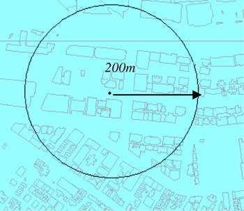
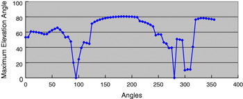
To evaluate the navigation performance, a number of points are sampled on the roads. A range of 200 metres of urban environment around the point is taken into consideration for navigation evaluation. More specifically, maximum elevation angles around obstructions are calculated. Figure 1 shows one of the sample points and Figure 2 shows the calculated maximum elevation angles of surrounding obstructions.
Close view of a sample point.

Maximum elevation angles of surrounding obstructions.

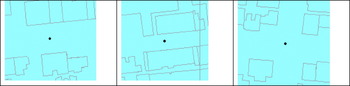
To model the urban environment, realistic 3D urban building information of Hong Kong was used and a series of transformations were conducted to make 3D building information and satellite's positions referenced to the same datum. According to the surrounding urban environment, sample points are classified into three categories based on the following rules (See Figure 3):
• If a point is located on a road wider than or equal to 20 metres, it was classified as the point in a major road.
• If a point is located on a road less than 20 metres wide, it was classified as the point in a minor road.
• If a point is located in the intersection of the roads, it was classified as the point in a conjunction area.
For sample points in a major road, the surrounding environment is full of buildings in N–S (or E–W) direction and the road width is about 24 metres; and for sample points located in a minor road it is also full of buildings in N–S (or E–W) direction and the road width is about 13 metres. For points in a conjunction area, it is free of buildings in the cardinal compass directions.
Points in a major road, a minor road, and a conjunction area [from left to right].

4. RESULTS AND ANALYSIS
This section illustrates the navigation performance of each choice in terms of availability, coverage, and continuity, based on simulations in Hong Kong.
4.1. Availability evaluation
To evaluate the navigation availability, a number of sample points were chosen on a major road, a minor road and a conjunction area in the coastal area of Hong Kong Island. To evaluate the availability performance, HDOP were calculated and averaged every 15 minutes, so there were a total of 96 navigation solutions for each sample point in a whole day. If there were no sufficient observations when the number of visible satellites is less than four, it was regarded as a failed solution. Otherwise, it was a computed solution. Among the computed solutions, only when HDOP was less than or equal to 10 was it regarded as successful.
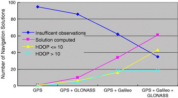
Figures 4, 5, and 6 show the results for a major road, a minor road, and a conjunction area respectively. From Figure 4, we can see that the choice of GPS+Galileo+GLONASS for a major road point performs best. It has the smallest number of solutions with insufficient observations and the largest number of solutions with HDOP⩽10. But the number of solutions with HDOP⩽10 is only slightly more than 40%.
Availability in a major road.

Availability in a minor road.

Availability in a conjunction area.

Figure 5 shows that the choice of GPS+GLONASS+Galileo still works best in a minor road point, but for more than 90% of the day, it was unable to provide navigation solutions in minor roads.
Compared with Figures 4 and 5, Figure 6 shows that the navigation availability in a conjunction area was much better. GPS+Galileo+GLONASS provided the highest number of successful solutions (HDOP⩽10), about 80, which is more than 80%. The combination of GPS+Galileo had the second highest number, about 60 and GPS+GLONASS the third, slightly more than 20. GPS alone had the lowest number, less than 10%.
Table 1 shows the percentage of successful navigation solutions (HDOP⩽10) achieved in each of the four urban environments. We can see that the availability in a conjunction area was highest, about 84% when the combination of GPS+GLONASS+Galileo was used. The availability in a major road was worse than in a conjunction area, with less than 50% when the combination of GPS+GLONASS+Galileo was used. The performance in a minor road was worst, almost zero, no matter which choice was used.
Availability in different urban environments.

4.2. Coverage evaluation
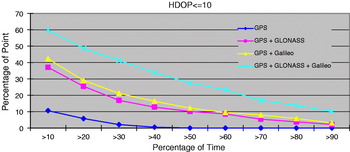
To evaluate the coverage performance, 189 sample points were selected, almost evenly spaced in a coastal area of Hong Kong Island covering Wan Chai, Causeway Bay, Sheung Wan, and Central (see Figure 7). Coverage performance is quantified by the percentage of tested points with percentage of time to provide successful navigation solutions (HDOP⩽10). The summarized results are displayed in Figure 8, which shows that the combination of GPS+GLONASS+Galileo performed best. The combinations of GPS+Galileo and GPS+GLONASS are second best and third best respectively. The most poorly-performed option is the use of GPS alone when for 50% of the time, none of the sample points have navigation solutions.
Study site to evaluate coverage performance.

Coverage performance.

However, it is noticeable that for all of the choices, the percentage of points with successful navigation solutions decreases dramatically with the increase of availability. Only 10% of points of GPS+GLONASS+Galileo could satisfy the requirements of 90% of navigation availability (HDOP⩽10). Only about 5% of points of GPS+GLONASS and GPS+Galileo could satisfy the 90% navigation availability requirement. So according to the general requirement of 90% coverage for applications in urban environment, the performance is far from satisfying even with GPS+Galileo+GLONASS.
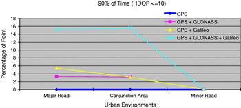
To evaluate the coverage difference in different categories of roads, the coverage performance satisfying 90% availability requirement in a major road, a conjunction area, and a minor road is shown in Figure 9, where we can see that the coverage performances in a major road and a conjunction area are very similar, only slightly more than 15% when GPS+Galileo+GLONASS is used. For minor roads, the coverage is almost zero.
Coverage comparison between a major road, a conjunction area, and a minor road, with 90% availability (HDOP⩽10).

4.3. Driving simulation
To evaluate the navigation performance in a more realistic way, we simulated a car to follow an approximate 8000 metre route over Wan Chai and Causeway Bay at a speed of 20 km/hour. The route and the sample points are shown in Figure 10. There were 187 sample points along the route, evenly selected with a separation between sample points of around 40 metres. The performance was evaluated in three aspects: the coverage along the route, temporal change of coverage along road, and continuity for each choice. Finally, we identified the roads which are unfavourable for navigation.
Sample points along the route.

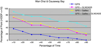
The coverage along the route was tested for each choice. The simulation results were similar to previous results – the percentage of time decreases gradually with the increase of availability (see Figure 11). GPS+Galileo+GLONASS performs best, but only about 40% of the points can meet the requirements of 90% availability requirement.
Coverage along the route.

Figures 12 and 13 show the temporal changes of performance with GPS alone and with GPS+Galileo+GLONASS. In these figures, green points represent the locations with HDOP values less than or equal to 10; red points represent HDOP values greater than 10; and black points represent HDOP values that cannot be calculated because of insufficient visible satellites (fewer than four). Figure 12 shows that only a few points located in open space areas have navigation solutions with GPS alone. Figure 13 shows the performance of integrated GPS+Galileo+GLONASS. Here most of the points have acceptable navigation solutions except in some specific areas. The plots of navigation performance with the GPS+GLONASS and GPS+Galileo are not shown; they are not as successful as the three system solution but have similar results to each other with the GPS+Galileo system having a slightly better performance.
Navigation performance with GPS alone.

Navigation performance at noon with GPS+GLONASS+Galileo.

Figure 14 illustrates the temporal change of coverage more clearly. It shows that the number of points with GPS alone along the route was the worst compared with the other integrated systems; during the period from 9am to 3pm only 5% of the points (10/187) could provide solutions. The number of successful points with the integrated GPS+Galileo and integrated GPS+GLONASS were similar. For the whole period of simulation, the combination of GPS+GLONASS+Galileo was the best. However it is notable that the number of points with acceptable solutions (HDOP⩽10) was not very stable. The acceptable points can reach up to 150 (nearly 80% of points) at 3am local time and then fall dramatically to 100 (nearly 55% of points) at noon. After 12 noon, the number of points rises gradually to 130 until 6pm, then falls slightly again, and eventually ends at 120 at 9pm.
Temporal change of coverage.

4.4. Continuity evaluation
Continuity is vehicle users' primary concern. It identifies the length of time needed for drivers to get the next navigation solution. Therefore, change over time of the minimum, average, and maximum distances without navigation signals were studied. The performance of GPS alone was much poorer than that of the integrated systems and is not plotted.
As seen in Figure 15, minimum distance between solutions is shortest with the GPS+GLONASS+Galileo integrated system. The pattern of the minimum distance for the two system integrations of GPS+Galileo and GPS+GLONASS is similar with fluctuations within a metre. Figure 16 shows that the average distance is once again always shortest with GPS+GLONASS+Galileo system. In general, the distance could be improved up to 40 metres for most of the time and the performance with three integrated systems was the most stable. The distance of around 60 metres for the whole of the simulation with the exception of a dip at noon. The longest maximum distance of around 400 metres with GPS+GLONASS+Galileo can be seen in Figure 17. Sometimes, the distance could be shortened to 200 metres. The results for the two system integrations of GPS+Galileo and GPS+GLONASS, were similar; the longest maximum distance in these cases could reach almost 1000 metres.
Temporal change of minimum distance.

Temporal change of average distance.

Temporal change of maximum distance.

4.5. Identification of unfavourable roads
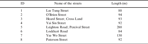
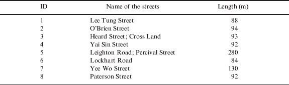
We set a condition that if more than three consecutive points are not able to obtain a navigation solution more than 60% of the time, the roads are identified as unfavourable roads for the use of the GNSS navigation systems. These roads are shown in Figure 18. The result shows that there are eight streets that are unfavourable for GNSS use. The names of these streets and their lengths are listed in Table 2.
Unfavourable roads for GNSS use.

Names of streets unfavourable for GNSS use.
5. CONCLUSIONS
In this paper, the navigation performance in the urban environment of Hong Kong is evaluated in terms of availability, coverage and continuity and four different choices of constellations (GPS alone, GPS+GLONASS, GPS+Galileo, GPS+Galileo+GPS) have been studied.
From the simulation results, the navigation availability with GPS+GLONASS+Galileo is best. Its availability is improved by around 25% in a conjunction area and a major road as compared with the second best choice of GPS+Galileo. However, in case of a minor road, availability is nearly equal to zero for all of the choices.
The results on coverage performance showed that GPS+GLONASS+Galileo is also the best from the four choices. Compared with the second best GPS+Galileo system, the percentage of points in a conjunction area and in a major road increased by 10%. But the coverage performance of all four system choices in a minor road is too poor to be evaluated. On the other hand, the coverage of GPS+GLONASS+Galileo in a major road and a conjunction area decreased with the increase of the availability.
The driving simulation investigated the whole day minimum, average, and maximum distances without navigation signals. From the simulation results, continuity by using GPS+GLONASS+Galileo is the best among the four choices. As compared with the second best, GPS+Galileo, the minimum distance is similar but, the average distance is shortened by 32%; and the maximum distance is shortened by 33%. At some specific times, the maximum distance can reach up to around 450 m with GPS+GLONASS+Galileo.
In summary, from the tested results, the combination of GPS+GLONASS+Galileo has the best performance in term of availability, coverage, and continuity. But its performance is far from satisfying most of navigation applications in an urban canyon such as Hong Kong.