


1. REGIONAL SATELLITE NAVIGATION SYSTEM CONSISTING OF GEO SATELLITES
Due to their high positioning precision and convenient usage, satellite navigation systems are widely used. At present, satellite navigation systems include Global Positioning System (GPS) and GLObal NAvigation Satellite System (GLONASS), with Compass and Galileo still under development. The composition and working principle of these four navigation systems are generally the same; Medium Earth Orbit (MEO) satellites are used to attain global coverage (at least four satellites need to be observed simultaneously) and the satellites are equipped with accurate high precision atomic clocks. The primary parameters for satellite navigation systems are the precise orbit determination of satellites and the accuracy of system time.
The developing Chinese Area Positioning System (CAPS) (Ai et al., 2008; Ai et al., 2009; Ai et al., 2011) is a regional satellite navigation system. The space segment of the system consists of leased Geostationary Earth Orbit (GEO) communication satellites and 2∼3 Inclined Geo-Synchronous Orbit (IGSO) satellites. The GEO above the Earth equator and the IGSO satellites provide a suitable geometric structure for users. The movement of these satellites relative to the ground is small, and therefore they provide stable coverage of the area for the navigation system. There are no onboard atomic clocks, while the satellite navigation signals are emitted from the ground (Figure 1). Although the construction of CAPS is different from the existing satellite navigation systems, with virtual atomic clock technology, users use the same procedures as the other ordinary satellite navigation systems (Li et al., 2009). With the technology of Paired Observation Combination for Both Stations (POCBS), high precision determination of satellite positions can be obtained with regional distribution of the stations.
Principle of the CAPS navigation system.

The primary parameters for CAPS, as with any satellite navigation system, are the precision of satellite orbit determination and accuracy of its system time. CAPS consists of sets of GEO and IGSO satellites placed at an altitude of 36 000 km (their geocentric distance is about 42 000 km). The angle of GEO satellites to Earth is very small (17·6°) and if the CAPS ranging stations are only placed within the boundaries of China, the angle of GEO satellites to the operating area is only few degrees. Viewed from space, the directions from the satellite to all ranging stations are nearly parallel. In addition, the period of GEO satellites orbiting the Earth is the same as the period of the Earth's rotation, so the movement of the satellites relative to the ground is very small, making it difficult to determine their orbits. Although one-way observation has a very high internal observational precision, it is difficult to separate the observation system errors from a one-way survey; therefore it is unsuitable for the GEO satellite precise orbit determination observations. The National Time Service Centre of the Chinese Academy of Sciences has proposed the POCBS method for high precision satellite orbit determination (Li et al., 2006; Li et al., 2003; Li et al., 2009; Yang et al., Reference Yang, Li, Feng, Guo, Shi, Ai, Wu and Qiao2009). This is a two-way observation technology, which is described in detail below. The advantage is that observation system error can be determined in real-time and the satellite orbit determination is independent of the determination of clock offsets. Thus, the precision of GEO satellite orbit determination is greatly improved, meeting the high precision requirement of the CAPS satellite orbits.
Virtual Atomic Clock technology uses real-time observation results in the master control station and gives the CAPS navigation system the capability of wide area augmentation, greatly weakening the impact of the satellite ephemeris errors and improving the positioning precision.
2. TECHNOLOGY OF SATELLITE ORBIT SURVEY CALLED PAIRED OBSERVATION COMBINATION FOR BOTH STATIONS
The satellite orbit survey called Paired Observation Combination for Both Stations (POCBS) (Li et al., Reference Li, Shi, Ai and Yang2006; Li et al., Reference Li, Li and Zhang2003) is based on two-way satellite time and frequency transfer (Lewandowski et al., Reference Lewandowski, Azoubib and Klepczynski1999; Imae, Reference Imae2000; Imae et al., Reference Imae, Hosokawa and Imamura2001). The atomic clock in each ground station generates precise and accurate time signals which are modulated by the pseudo code. The modulated time signals of all stations with the same carrier frequency are simultaneously dispatched to the same satellite; the receivers on the ranging stations receive the signals from all stations via the satellite. Thus the time delay of the signals from a ground station to another ground station via the satellite is precisely measured by the combination of a pair of observables and the impact of the atomic clock offset at each station is completely eliminated. The generation and measurement of ranging signals for the orbit determination are carried out in the ground stations, whose self-correction systems correct the instrument system errors. The principle of satellite orbit survey by transfer is shown in Figure 2.
Observation principle of satellite orbit survey by transfer.

Suppose that the time signal generated by the atomic clock at station i is modulated and then dispatched to the satellite, the satellite transfers the signals from station i to station j, and the signals from station i are demodulated at station j and the time delay of the signals on the path is determined. Corrected the impact of the Earth's rotation, ionosphere and troposphere, the time relationship for the signals can be expressed as:

where:
t i is the moment the signal is received from station i by the satellite.
I it is the instrument delay of emitting signals for station i.
I jir is the receiver delay at station j that receive signals from station i.
ρ i(t i) is the distance (with the speed of light as its unit) between the antenna phase centre of station i and the satellite antenna phase centre at the moment the signal is received from station i by the satellite.
ρ j(t i) is the distance (with the speed of light as its unit) between the antenna phase centre of station j and the satellite antenna phase centre at the moment the signal is received from station i by the satellite.
ΔT i is the clock offset at station i with respect to the master station.
R ji(t i) is the observation value at the station j, received the signal from station i without the impact of the Earth's rotation, ionosphere and troposphere.
τ s is the satellite transponder time delay.
Consider a paired observation: the receiver at station j receives the signal from station i and the receiver at station i receives the signal from station j. From Equation (1), the time relationship of the POCBS is:

Set the atomic clocks at the two stations to be synchronous for the duration of the observation of the orbit survey. The resulting difference in the time delay of the signals on the path from each station to the satellite is just a few dozens of milliseconds, thus t i is quite close to t j, so let:

ρ i(t i) can be expanded into a Taylor series, and by taking its first order term, we have:
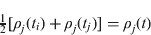
and:

Then Equation (2) becomes:

Equation (5) is the fundamental equation for the satellite orbit determination of POCBS. The second and third terms on the right hand of Equation (5) are the sum of the instrument emitting and receiving time delays of each station, which can be easily measured in real-time. There are no parameters of clock offset for any station in Equation (5), showing that the clock offset for any station does not affect the orbit survey. Equation (5) represents the ellipsoid of revolution centred at the two stations and has different physical attributes from other methods of satellite orbit survey.
If a station receives the signals emitted by itself (i.e., i=j), then Equation (5) becomes:

The observation system for orbit survey consisting of N stations has N sets of observation in Equation (6); in this case each ellipsoid of revolution degenerates into a sphere centred at the station.
In order to construct an observation system of satellite orbit survey conveniently, only the paired observations combination between the master station and each slave station are used, thus (N−1) sets of the paired observations combination are obtained and plus N observation equations of the stations receiving the signals emitted by themselves, altogether (2N−1) independent observation equations can be applied to satellite orbit determination.
The CAPS satellite orbit survey system has constructed five ground stations in China: Shanghai (SH), Changchun (CH), Xi'an (XI), Kunming (KU) and Urumochi (UR), of which station XI is the master station. The time signals of each station are generated by a caesium atomic clock, the pseudo code rate of the spread spectrum signals is 20 MHz, the antenna aperture is 3·7 m, the emission power is 1 W, the ratio of the actually measured carrier to noise is better than 60 dBHz, and the actually measured ranging precision for the pseudo code in 1 second accumulated time is better than 1 cm (Table 1).
Statistics of ranging error of 5 observation stations of CAPS.

The satellite orbit determination for the CAPS project using POCBS has been implemented over six years. Table 2 shows the residuals of (GEO) orbit determination for SINOSAT-1 during the observation period of 6∼18 June, 2005. The dynamic method is used for precise orbit determination with one day arc segment observation data (Oliver Montenbruck et al., Reference Oliver and Eberhard2000; Escobal, Reference Escobal1976). For each arc segment, it solves 6 orbit parameters, 3 sunlight pressure parameters, 2×3 horizontal empirical acceleration parameters in the ‘along-track’ direction, 3 satellite transponder time delay parameters, 3 transponder time delay change rate parameters; altogether this solves 21 parameters.
Residuals of one day arc segment joint solutions.

The orbit precision is represented by the orbit overlaps. The orbit overlaps vary significantly, as the orbit quality is highly correlated with the number and temporal distribution of the observations. The resulting orbit differences (referred to as orbit overlaps in the following) indicate the orbit quality. Small overlaps indicate a good quality, whereas large overlaps indicate a bad quality of the determined orbit. We assume that the central part of an arc is best defined and that the boundary parts of an arc are worst defined. For a consecutive 3-day orbit, its ‘head and tail’ is each cut by 0·5 day to achieve a consecutive 2-day arc orbit. The 1-day forward and backward overlapped orbit difference of these consecutive 2-day orbits represents the orbit precision. The statistical results are shown in Table 3. The radial orbit overlaps show values of up 13·6 cm (drms), the average in along-track direction is 9·1 cm (drms) and in normal direction is 11·0 cm (drms). The orbit difference of the overlapped part at position is 20·1 cm (drms).
Statistics of mean square values of overlapped orbit differences in RTN (Metres).

With the POCBS method of satellite orbit determination, the time synchronization and determination of orbits are carried out independently and the errors of time synchronization do not affect the determination of the orbits, hence the geometric Position Dilution Of Precision (PDOP) is greatly improved. The generation and the measurement of ranging signals are performed on the ground; there is a self-correction system in each ground station, which precisely measures the variations of the instrument system error in real-time. Therefore the observation system is stable and has achieved a breakthrough in observational precision.
3. VIRTUAL ATOMIC CLOCK TECHNOLOGY
Like GPS, GLONASS and other satellite navigation systems, the foundations of the CAPS navigation system are:
• Providing precise navigation satellite orbit data.
• Providing precise time of the signals at the phase centre of the satellite antenna, whose precision in some sense determines the advantage, disadvantage and performance of the navigation system.
The receivers on the ground receive satellite navigation signals and obtain the difference between the time of emitted signals by satellite (satellite clock time) and the time of received signals (receiver time). If the signals of more than four properly distributed satellites are received by a receiver, the three-dimensional coordinates of the reception location and the receiver clock offset can be obtained. The positioning precision of the satellite navigation system depends on the orbit precision, precision of time and the precision of the signal time delay correction on the path (ionosphere correction, neutral atmosphere correction and relativity correction) (Li et al., 2008).
If the satellite signal is emitted at the moment t s(t) (relative to the onboard clock), it corresponds to the time t related to system time. If a signal from the satellite is received by the receiver at the moment t u(t+τ) (relative to the receiver clock), it corresponds to the time t+τ related to system time. The time delay of signal from the satellite to the receiver on the path is τ, and the receiver measurement value ρ(t) (pseudo with the speed of light as its unit), then:

Clearly, ρ(t)≠τ which is affected by the satellite clock offset and the receiver clock offset. Their relationship, shown by navigation system time is therefore:

and:

where Δt u(t+τ) and Δt s(t) are the receiver clock correction and satellite clock correction relative to the navigation system time, respectively.
The receiver measurement value ρ(t) (as before, the measurement value has been corrected by the impact of the Earth’ rotation, ionosphere and troposphere) is denoted by the navigation system time:

The signal travel time in vacuum over the geometrical distance from the satellite to the station is τ. If the satellite position vector is  and the position vector of the station is
 , then the measurement value (Figure 3) is:

Impact of the satellite ephemeris errors.

In fact, it is not possible to establish the true position of the satellite  at the moment of observation, but the predicted position
 can be established. If the predicted satellite position error vector related to the real satellite position vector is
 , by which the pseudo error dρ(t) caused is:

where  is the unit vector in the direction from the receiver to the satellite.
Considering the errors of predicted satellite position, Equation (10) becomes:

It can be seen that the satellite navigation precision is depended on the ephemeris precision and the precision of determination of the satellite clock offset.
Current navigation satellites (i.e., GPS, GLONASS, Galileo and Compass) all have onboard atomic clocks and system time is provided by these onboard atomic clocks. However, CAPS is a transfer system and there are no atomic clocks on the satellites. There is only the atomic clock in the master ground station to keep system time. Virtual clock technology overcomes the lack of on-board atomic clocks on satellites. The time of emission of the signal at the ground station transforms to the transfer time of the signal at the phase centre of the antenna of the satellite and this is equivalent to putting atomic clocks into the satellites.
Figure 4 shows the principle of the virtual clock. For convenience, suppose that station m is the master station and the time emitted by the master station is the system time (i.e., ΔT m=0). Then,  is the time delay of uplink signal from the clock at the master station to the satellite. If I jir is re-written as I jr, and t i as t, and correspondingly if ρ j(t i) is re-written as ρ j(t), and R ji(t i) as R j(t), then Equation (1) becomes:

Principle of virtual clock technology.

If the master station also receives its own signal, Equation (1) becomes:

Substituting Equation (13) into (12), we obtain:

Compared with Equation (11), the second term on the right-hand side of Equation (14) is the virtual clock correction.
4. IMPACT OF VIRTUAL CLOCK AND ORBIT ERRORS ON POSITIONING
As stated earlier, the satellite position cannot be established precisely at the moment of observation, and can only be replaced by a predicted ephemeris. For CAPS, the difference between them is under 2 metres. The error vector of the satellite predicted positions is denoted by  , of which the error caused by pseudo ρ j(t) is dρ j(t) and that of ρ m(t) is dρ m(t), thus:


and the corresponding equations for computing pseudo are


where:
 and are the unit vectors in the sight line direction of station j and the master station.
τ j and τ m are distance from satellite to the station with receiver and master station.
Equation (14) then becomes:

It is not difficult to see that to affect the satellite navigation precision the only error is caused by the satellite ephemeris  , provided that the instrument errors of receivers are precisely measured (the impact of instrument errors of receivers is the same as that of the clock offset mentioned before).
CAPS uses either GEO or IGSO satellites, which are at an altitude of 36 000 km. The master station is located at China's geographic centre, thus  and
 are almost parallel, and the differences between
 and
 are:

where:


The above formula can be rewritten as:

where:
d is the distance from the measuring point to the master station.
- is the unit vector of the master station pointing to the measuring point with the receiver.
 is the unit vector of the master station pointing to the measuring point with the receiver.
It can be seen from Equation (14) and (15) that the impact of ephemeris errors is greatly reduced by the virtual clock technology, which has been reduced by 1∼2 orders of magnitude within the area of China. The reduction factor is the ratio of the distance between the satellite and the master station to the distance between the master station and the measuring point.
5. CONCLUSION
CAPS is a regional satellite navigation system and its space segment consists of GEO satellites and 2∼3 IGSO satellites. The transfer mode is employed in CAPS and there are no atomic clocks in the satellites. Using the virtual clock technology enables CAPS to have a wide area augmentation capability. The navigation satellite orbit determination uses a novel method called Paired Observation Combination for Both Stations (POCBS), and although the orbit survey stations are located in an unfavourable regional distribution, a high precision of orbit determination can still obtained.
ACKNOWLEDGEMENT
This work was carried out under the support of the National Basic Research and Development Program of China (Grant No. 2007CB815503).



