




No CrossRef data available.
Multi-scale spatial analysis of human alveolar echinococcosis risk in China
Published online by Cambridge University Press: 04 March 2004
Abstract
Risk factors for the transmission of Echinococcus multilocularis to humans operate at a range of spatial scales. Over a large area, such as China, regional scale risk is correlated with variation in climatic conditions because of its effect on the spatial distribution of landscapes that can support E. multilocularis transmission in wildlife hosts and the probability of egg survival. At a local scale of a few kilometres, or tens of kilometres, transmission risk is related to the spatial proximity of human populations and landscapes with active transmission. At the patch scale, when considering individual villages or households, human behavioural factors are important and for individuals genetic and immunological factors play a role. Satellite remote sensing can provide landscape information at a range of spatial scales and provide a spatial framework within which to examine transmission patterns. This paper reviews the application of remotely sensed data and spatial data analysis to develop a better understanding of disease transmission and shows how such data have been used to examine human alveolar echinocossosis infection patterns, at a range of spatial scales, in an endemic area in central China.
Information
- Type
- Research Article
- Information
- Copyright
- © 2003 Cambridge University Press
INTRODUCTION
The sustainable transmission of Echinococcus multilocularis in wildlife depends on the spatial interaction of susceptible small mammal intermediate and canid definitive host populations in a landscape that supports the hosts at critical population densities. At a regional scale it has been suggested that the distribution of human alveolar echinococcosis (AE) and the endemicity of E. multilocularis transmission in wildlife across China is related to spatial variation in climate through its control on vegetation and landscape (Zhou et al. 2000). The presence, or absence, of susceptible hosts within a particular landscape type is related to the spatial distribution of suitable habitats due to their affect on food availability, predation, and host population dynamics (Giraudoux et al., this supplement). Within endemic areas, local-scale spatial variation in transmission of E. multilocularis is likely to be related to landscape composition and habitat connectivity that affects host population dynamics, and also to microclimatic variations in temperature and humidity that affect egg viability (Veit et al. 1995).
At the community scale there may also be spatial variability associated with compatibility and genotype of both definitive and intermediate hosts and other parasite-specific factors that affect egg production, protoscolex production and host susceptibility. The genetic basis for variation in E. multilocularis susceptibility of intermediate rodent hosts is shown by different growth rates and protoscolex production of metacestodes in different strains of experimentally infected mice, reflecting a range from relatively resistant, to highly susceptible hosts within a species (Pater et al. 1999). Variability in genetic susceptibility of definitive canid hosts has not been studied in detail; however, epidemiological data from Europe suggested that sub-adult red foxes tend to carry significantly higher worm burdens than adult foxes, though prevalence rates were similar by age and sex (Hofer et al. 2000). Recent epidemiological data collected from dogs naturally infected with E. granulosus indicated both overdispersal and an age-specific effect with decreasing prevalence in older dogs (Torgerson et al. 2002). Evidence of significant genetic heterogeneity in E. multilocularis is not strong; however, mitochondrial gene sequence analysis has indicated geographical differences for Alaskan and European isolates (Rinder et al. 1997).
Human infection with E. multilocularis occurs either through direct contact with an infected host, normally a canid species, or indirectly from a contaminated environment. There are isolated examples of infection in individuals from non-endemic areas, but in most cases human infection occurs in endemic areas where there has been prolonged exposure to infected canids, or to an environment where there is regular contamination by E. multilocularis eggs. Infection is therefore most likely to occur where human populations are juxtaposed with regions of active E. multilocularis transmission in wildlife, although a range of human-behavioural and genetic factors are also likely to be important. For example, increased risk of clinical AE in Chinese females in south Gansu may be due to greater and closer contact with infected dogs (Craig et al. 2000). Genetic characteristics of populations in endemic areas may also affect immune responses to the extent of causing abortive infections as has been observed in Alaska, Europe and China (Gottstein, Schantz & Wilson, 1985; Bresson-Hadni et al. 1994; Bartholomot et al. 2002).
A multi-scale spatial analysis of E. multilocularis transmission requires data on landscape and parasite hosts, while analysis of human AE risk requires data on the location and behaviour of human populations. Research to date has focused primarily on the identification and mapping of infected animals and infected humans, and has not fully explored the interaction of landscape with potential hosts and human populations in determining transmission intensity and human AE risk. This paper illustrates how data derived from satellite remote sensing systems and spatial data analysis are being used in an interdisciplinary research programme that aims to explain the ecology and epidemiology of E. multilocularis transmission in an endemic area in central China. The work aims to develop risk models for human AE that can be applied in the management and control of this rare pathogenic disease in endemic areas around the world.
SATELLITE REMOTE SENSING IN EPIDEMIOLOGY
The application of remotely sensed data and spatial analysis in parasitic disease transmission studies is now well established and has been reviewed extensively elsewhere (e.g. Kitron, 1998; Hay, Randolph & Rogers, 2000). Satellite remote sensing provides images of the Earth's surface with spatial resolutions between about one metre and several kilometres and with a revisit cycle (time interval between imaging a given point on the Earth's surface) between one and 26 days (Table 1). In general, there is a trade-off between spatial resolution and the ground coverage of the data. For example, the 1 m spatial resolution Ikonos sensor images an area of only 11×11 km whereas the 30 m spatial resolution Landsat TM or ETM+ image an area approximately 185×185 km, and the 1·1 km spatial resolution NOAA AVHRR images a strip almost 3000 km wide. The selection of appropriate satellite sensor data is determined by the application but depends primarily on the size of the study area and the spatial and temporal resolution required. A further consideration is the time period over which data are required. Many epidemiological problems require information on the current or recent state of vegetation or land cover; other studies require historical data on past vegetation and land use change. In the latter case, the length of the archive of remotely sensed data becomes relevant and, as the examples in Table 1 show, may influence the selection of remotely sensed data.

Identification of mosquito habitats presents perhaps the most extensive epidemiological use of remote sensing to date. Mosquitoes are important vectors in the transmission of Plasmodium protozoa (malaria), Wuchereria bancrofti and Brugia malayi nematodes (lymphatic filariasis or elephantiasis) and arthropod-borne viruses (yellow fever, dengue fever and Rift Valley fever). The close association of mosquitoes with fresh or brackish water has allowed fine spatial resolution remotely sensed data to be used to map the habitat of larval mosquito populations (Wood et al. 1992). These data have also been combined with spatial measures of distance between village and mosquito habitat to estimate risk of malaria transmission around villages (Rejmánková et al. 1995; Beck et al. 1997; Thomas & Lindsay, 1999). Landscape also influences the distribution of small mammal host populations and again remotely sensed data can provide a tool with which to map landscape composition. For example, Langlois et al. (2001) demonstrated that the distribution of deer mice (Peromyscus maniculatus) infected with hantavirus was correlated with landscape composition, measured using aerial photographs, in 2 km radius buffer zones around trap locations.
In the case of E. multilocularis recent research has shown that the spatial distribution of infected foxes in endemic areas of Europe may be related to landscape composition. Staubach et al. (2001) examined the landscape in 2·5 km radius buffer zones around the positions of 3521 foxes and found that infected foxes were more likely to be found in areas with higher pasture cover and lower forest cover. Other studies have examined E. multilocularis infection in definitive and intermediate hosts in a range of environments (Eastman & Worley, 1979; Saitoh & Takahashi, 1998; Raoul et al. 2001; Berke, 2001; Deplazes et al. 2002) but this is the first study to use remotely sensed data to examine relationships between multi-scale spatial variation in landscape composition and spatial variation in human AE infection.
SPATIAL DISTRIBUTION OF HUMAN AE IN CHINA
Based on data collected from ecological and prevalence studies in Gansu (Giraudoux et al. 1998) and Xinjiang (Zhou et al. 2000) Zhou (2001) hypothesised that at a regional scale, the spatial distribution of E. multilocularis in China is related to climatological and landscape factors. The distribution of susceptible small mammal intermediate hosts is likely to be correlated with the distribution of grassland landscapes, which occur across much of central and western China. To test this hypothesis, land cover data were obtained from the US Geological Survey (USGS) Land Cover Characterisation Programme generated as part of the International Geosphere-Biosphere Programme (IGBP). The IGBP land cover data set is derived from 1·1 km spatial resolution Advanced Very High Resolution Radiometer (AVHRR) data collected over a 12-month period between April 1992 and March 1993. The data are transformed into a monthly composite of normalised difference vegetation index values (NDVI) and an unsupervised classification applied before decision rules are used to create land cover classes (Loveland et al. 2000). For this research, the data set, initially mapped using a Goode Homolosine projection, was re-registered to Universal Transverse Mecator (UTM) projection using a mask of China and a GTOPO30 digital elevation model also obtained from the USGS. The nominal pixel size of the data is 1 km and there are 17 land cover classes (Table 2). In this study, the grassland class 10 was extracted and mapped for the whole of China.

Very few studies have identified E. multilocularis in wildlife in China so that direct correlation of parasite spatial distribution and landscape is not yet possible. However, published data on the hospital records of human AE cases across China have been derived by Zhou (2001) and in this study these data were taken as a surrogate for the geographical distribution of active E. multilocularis transmission. The human AE data, extracted from an extensive literature search, identify counties where one or more AE cases were recorded (in China, County is an administrative sub-division of Province). Using a base-map of all 2462 counties in China, all those counties with reported AE cases were plotted on a UTM grid using a centroid point and overlaid on a map showing the spatial distribution the IGBP grassland class (Fig. 1). The spatial correlation between the spatial distribution of grassland and the spatial distribution of AE is very clear. The main endemic areas correspond to the central and eastern Tibetan grasslands and a corridor of grassland extending to the north-east through the provinces and Autonomous Regions of Gansu and Ningxia, and the pasture lands of Xinjiang Autonomous Region in the north-west. In contrast, the grassland areas of Inner Mongolia in the north east of the country appear to have low number of AE cases.

Fig. 1. Spatial correlation of counties with human AE cases (black points) in China and grassland land cover (dark grey) from IGBP global land cover classification. Grid system is Universal Transverse Mercator (metres) referenced to an origin in zone 47 N.
This preliminary analysis indicates that, although the presence of grassland landscapes in China appears to be favourable for E. multilocularis transmission, there are areas with grassland but no current records of human AE, and other areas where there is no grassland but AE is present. However, human AE has a long incubation period (5–15 years) and is difficult to diagnose so that cases in rural settings may not be recognised (Craig et al. 2000). There are clearly other factors affecting the distribution of the disease at this spatial scale amongst which climate and land use change may be the most important. For example, the drier hotter areas of Inner Mongolia may be unsuitable for long-term egg survival, while other areas where there has been significant land use change from grassland or forest to intensively cropped land may no longer support active transmission because of the effects on sylvatic host population distributions. Further investigation of these factors is now being undertaken in order to gain a better understanding of the China-wide spatial variation in transmission risk. Climatological data are being used to define the temperate bioclimatic zones within which E. multilocularis eggs may remain viable, with temperature and rainfall seasonality taken into account. Data will also be obtained on the spatial distribution of susceptible hosts across China and the data integrated to develop and test a predictive mode for the country-wide distribution of E. multilocularis transmission and human AE risk.
RISK AT LOCAL SCALE
At the local scale it is now hypothesised that spatial variation in E. multilocularis is related to the ecology of small mammal intermediate hosts and in particular the spatial arrangement of optimal habitat (Giraudoux et al., this supplement). Previous research in an endemic region in southern Gansu Province identified a strong link between landscape composition and human AE prevalence within a 30×30 km study area (Craig et al. 2000; Giraudoux et al. 2002; Danson et al. 2003). Landscape around 31 villages in Zhang county, southern Gansu, with human AE prevalence rates between 0 and 15%, was assessed using 79 m spatial resolution Landsat MSS data recorded in 1975. Archived data from 1975 were used because of the five to 15 year time lag between human infection with E. multilocularis and the detection of the disease. The spatial variation in village AE prevalence determined in surveys during the mid 1990s is likely to relate to infection that occurred at some time in the past five to 15 years. The remotely sensed satellite data were registered to a UTM grid using ground control points collected in at the field site and a ‘maximum likelihood’ classifier (Mather, 1997) was used to produce a map with five land cover classes: forest, tree/shrub, grass/shrub, grassland and agricultural fields. The classes chosen were used in an earlier ecological survey (Giraudoux et al. 1998) which found susceptible intermediate hosts in a range of habitats related to forest clearance for agriculture and, in some areas, secondary succession by shrubs and trees.
The proportions of each land cover type were determined for circular ‘buffer-zones’ of different sizes (500–3500 m radius in 250 m increments) around each village and a forward step-wise linear regression analysis was used to assess the correlation between land cover proportions and village AE prevalence. A multiple regression model, incorporating proportions of shrubland and grassland habitat in the area around villages, accounted for 75% of the variation in village AE prevalence illustrating the strong link between landscape and AE transmission risk (Danson et al. 2003).
A key limitation of this initial study was that additional aspatial risk factors, such as gender and age, were not included. Questionnaire data collected during the human ultrasound screening surveys in the 1990s (Bartholomot et al. 2002) sought information on gender, occupation, dog ownership and other behavioural factors (Craig et al. 2000). These aspatial data have now been included in a logistic regression analysis with input data on 2482 screened subjects and spatial data on the landcover composition around villages derived from the previous work. In the first stage forward step-wise regression identified age, occupation, and ownership of scavenging dogs as significant aspatial risk factors (Model 1, Table 3). However, introduction of landscape variables in a second stage of the modelling gave rise to the elimination of gender, occupation and dog ownership with two landscape variables having a higher level of significance than the remaining aspatial variable, age (Model 2, Table 3). To visualise the risk across the study area the logistic regression model was applied to a land cover map of the complete study area. The resulting map (Fig. 2) shows significant spatial variation in the risk of transmission to humans and illustrates the spatial complexity of risk caused by landscape variability.

Fig. 2. Land cover map of Zhang study area, south Gansu, with observed AE prevalence and predicted AE prevalence from logistic regression Model 2.

RISK AT PATCH SCALE
Direct study of the spatial distribution of E. multilocularis eggs in the environment is difficult because of their microscopic size and the time-consuming laboratory analysis required to isolate and then identify the species using DNA probes. Studies of infection rates in foxes using coproantigen tests on faeces have been successful in areas with high rates of infection (Raoul et al. 2001; Deplazes et al. 2002) but to date there have been no comparative studies in endemic areas in China. Very little research has been conducted to examine the patch scale spatial variation in the risk of transmission of E. multilocularis to humans. The work outlined earlier suggests that variation in AE prevalence from village to village is strongly influenced by the proximity of landscapes that support E. multilocularis in wildlife. However, variations in infection rates between households or families within a single village are not well understood. Part of the variation is likely to be caused by behavioural factors that increase, or decrease, the probability of infection, while immunity and susceptibility effects are also likely to be important.
Studies have indicated that over-dispersion of the parasite in space and time may be a general pattern (Giraudoux et al. 2002). For example, in France, Switzerland and Japan, micro-foci of some ten square metres have been identified. In these small areas, E. multilocularis prevalence rates in intermediate rodent hosts may be one hundred times higher (15–20%) than those observed over larger areas. This may be explained by higher local densities of intermediate hosts, higher concentration of definitive host faeces or burying of faeces (e.g. by cattle stamping) which may increase parasite egg survival. Parasite over-dispersion is also common in definitive hosts; Hofer et al. (2000) found that 7·5% of a fox population in Switzerland harboured 72% of the parasite worm biomass with similar patterns observed in eastern France (Raoul et al. 2001). This means that the behaviour of a sub-group of a local fox or possibly dog population around a village may be more important than the ‘average’ behaviour of the definitive host population. Human infection is more likely when exposure is frequent, although in general few people develop AE. This means that actual risk for human infection with E. multilocularis can only be examined through long-term cohort studies of individuals exposed to the parasite. The design of such studies would be complex, requiring the application of a nested hierarchy of factors and processes acting at a local scale (Allen & Star, 1982; Allen & Hoekstra, 1991). In addition to studies of human behaviour, long-term investigations, over ten years or more, would be necessary to examine small mammal population dynamics, definitive host faeces distributions, and egg distribution at a range of scales from micro-foci of several square metres to macro-foci over several square kilometres. The cost and logistical problems associated with such a study mean that this research has still to be carried out.
Our current research in a highly endemic area of the Tibetan plateau is assessing spatial variability in transmission risk by mapping of E. multilocularis infection in domestic dogs. The study area in western Sichuan is a grassland region with Tibetan communities of Yak herders and small village-based permanent populations. In an initial study, 167 faecal samples were collected via a purge or rectal sample from domestic dogs in the village of Niniu, Ganze Prefecture. Three samples were collected simultaneously for enzyme linked immunoassay (ELISA), one for PCR (in 70% ethanol) and one for visual inspection for the presence of E. multilocularis and E. granulosus worms and dietary analysis. A Global Positioning System (GPS) measurement was made with a hand-held receiver at each sampling location and the dog owner interviewed. Information was obtained on the age and name of the dog, history of dog ownership, name of principal carer of the dog, knowledge of hydatid disease, both AE and cystic echinococcosis (CE), and the presence or absence of AE/CE patients in the household. The use of GPS for recording the location of a sample point will not only allow spatial analysis of dog infection patterns (e.g. spatial clustering) but will also enable the researcher to return to the same dog and obtain a repeat sample. From parallel small mammal studies in this area it may be assumed that high densities of pika (Ochotona sp.) and voles (Microtus sp.) are permanently accessible to dogs. In addition, red fox (Vulpes vulpes) and Tibetan fox (Vulpes ferrilata) populations provide the conditions for sustained and intensive transmission of E. multilocularis. Human surveys that are currently underway in Tibetan communities will allow local scale risk of AE transmission to be examined in relation to dog infection patterns (Schantz & Qui, this supplement).
CONCLUSIONS
This paper has explored the factors affecting the transmission of E. multilocularis to human populations at a range of spatial scales. Further advances in understanding and predicting transmission risk will require a multi-disciplinary approach that integrates studies of human epidemiology with ecological studies of small mammal intermediate host and definitive host ecology. It is apparent that these studies should be set in a spatial context since, as this paper shows, the spatial distribution of risk at a range of scales is highly dependent on landscape composition and structure. The critical role of satellite remote sensing has been illustrated by reference to published research and to studies currently underway in endemic areas of central China. Satellite remote sensing provides an effective tool for mapping the dynamic nature of landscape change and provides a spatial reference system upon which risk models may be developed.
ACKNOWLEDGEMENTS
This research is funded by a grant from the US National Institutes of Health and National Science Foundation Ecology of Infectious Diseases Program (TWO1565-02). The authors acknowledge the invaluable comments of the reviewers of this paper.
References
REFERENCES
ALLEN, T. F. H. &
HOEKSTRA, T. W.
(1991).
Role of heterogeneity in scaling ecological systems under analysis. In Ecological Heterogeneity (ed. Kosala, J. & Pickett, S. T. A.), pp. 47–68.
New York, Springer Verlag.CrossRef
ALLEN, T. F. H. &
STARR, T. B.
(1982).
Hierarchy – Perspectives for Ecological Complexity. Chicago,
University of Chicago Press.
BARTHOLOMOT, B.,
VUITTON, D. A., HARRAGA, S.,
SHI, D. Z.,
GIRAUDOUX, P.,
BARNISH, G.,
WANG, Y. H., MACPHERSON, C. N. L. &
CRAIG, P. S.
(2002).
Combined ultrasound and serologic screening for hepatic alveolar echinococcosis in central China. American Journal of Tropical Medicine and Hygiene 66, 23–29.CrossRefGoogle Scholar
BECK, L. R.,
RODRÍGUEZ, M. H.,
DISTER, S. W., RODRÍGUEZ, A. D.,
WASHINO, R. K., ROBERTS, D. R. &
SPANNER, M. A.
(1997).
Assessment of a remote sensing based model for predicting malaria transmission risk in villages of Chiapas, Mexico.
American Journal of Tropical Medicine and Hygiene 56, 99–106.CrossRefGoogle Scholar
BERKE, O.
(2001).
Chloropleth mapping of regional count data of Echinococcus multilocularis among red foxes in Lower Saxony, Germany. Preventative Veterinary Medicine 52, 119–131.CrossRefGoogle Scholar
BRESSON-HADNI, S.,
LAPLANTE, J. J., LENYS, D., ROHMER, P.,
GOTTSTEIN, B.,
JACQUIER, P.,
MERCET, J.,
MIGUET, J. P. & VUITTON, D. A. (
1994). Seroepidemiologic screening of Echinococcus multilocularis infection in a European area endemic for alveolar echinococcosis.
American Journal of Tropical Medicine and Hygiene 36, 576–585.CrossRefGoogle Scholar
CRAIG, P. S., GIRAUDOUX, P., SHI, D.,
BARTHOLOMOT, B.,
BARNISH, G., DELATTRE, P.,
QUÉRÉ, J.-P., HARRAGA, S.,
BAO, G.,
WANG, Y.,
LU, F. &
VUITTON, D. A.
(2000).
An epidemiological and ecological study of human alveolar echinococcosis transmission in south Gansu, China. Acta Tropica 77, 167–177.CrossRefGoogle Scholar
DANSON, F. M., CRAIG, P. S.,
MAN, W.,
SHI, D. &
GIRAUDOUX, P.
(2003).
Landscape dynamics and risk modelling of human alveolar echinococcosis. Photogrammetric Engineering and Remote Sensing (in press).Google Scholar
DEPLAZES, P.,
GLOOR, S.,
STEIGER, C. &
HEGGLIN, D.
(2002).
Urban transmission of Echinococcus multilocularis. In Cestode Zoonoses: Echinoccosis and Cystercercosis: an Emergent Global Problem (ed. Craig, P. S. & Pawlowski, Z.), pp. 287–297. Amsterdam, IOS Press.
EASTMAN, K. L. & WORLEY, D. E. (
1979). The muskrat as an intermediate host of Echinococcus multilocularis in Montana.
Journal of Parasitology 65, 64–72.CrossRefGoogle Scholar
GIRAUDOUX, P.,
DELATTRE, P.,
BAO, G.,
WANG, X.,
SHI, D., VUITTON, D. A. & CRAIG, P. S.
(1998).
Distribution of small mammals along a deforestation gradient in southern Gansu, Central China. Acta Theriologica 43, 349–362.CrossRefGoogle Scholar
GIRAUDOUX, P.,
DELATTRE, P.,
TAKAHASHI, K.,
RAOUL, F.,
QUERE, J.-P.,
CRAIG, P. S. & VUITTON, D. A. (
2002). Transmission of ecology of Ecinococcus multilocularis in wild-life: what can be learned from comparative studies and multi-scale approaches? In Cestode Zoonoses: Echinoccosis and Cystercercosis: an Emergent Global Problem (ed. Craig, P. S. & Pawlowski, Z.)
, pp. 251–266. Amsterdam,
IOS Press.
GOTTSTEIN, B.,
SCHANTZ, P. M. & WILSON, J. F. (
1985). Serological screening for Echinococcus multilocularis infections with ELISA.
Lancet 1, 1097–1098.CrossRefGoogle Scholar
HAY, S. I.,
RANDOLPH, S. E. & ROGERS, D. J. (eds) (
2000). Remote sensing and geographical information systems in epidemiology.
Advances in Parasitology 47, 1–357
.Google Scholar
HOFER, S.,
GLOOR, S.,
MÜLLER, H.,
MATHIAS, A.,
HEGGLIN, D. &
DEPLAZES, P.
(2000).
High prevalence of Echinococcus multilocularis in urban foxes (Vulpes vulpes) and voles (Arvicola terrestris) in the city of Zurich, Switzerland. Parasitology 120, 135–142.CrossRefGoogle Scholar
KITRON, U.
(1998).
Landscape ecology and epidemiology of vector-borne diseases: Tools for spatial analysis. Journal of Medical Entomology 35, 435–445.CrossRefGoogle Scholar
LANGLOIS, J. P., FAHRIG, L.,
MERRIAM, G. & ARTSOB, H.
(2001).
Landscape structure influences continental distribution of hantavirus in deer mice. Landscape Ecology 16, 255–266.CrossRefGoogle Scholar
LOVELAND, T. R., REED, B. C., BROWN, J. F.,
OHLEN, D. O., ZHU, J.,
YANG, L. &
MERCHANT, J. W.
(2000).
Development of a Global Land Cover Characteristics Database and IGBP DISCover from 1-km AVHRR Data. International Journal of Remote Sensing 18, 1303–1330.CrossRefGoogle Scholar
MATHER, P. M.
(1997).
Computer Processing of Remotely Sensed Images, 2nd edn. Chichester, Wiley.
PATER, C.,
MULLER, V.,
HARRAGA, S.,
LIANCE, M.,
GODOT, V.,
CARBILLET, J. P.,
MEILLET, D.,
ROMIG, T. &
VUITTON, D. A.
(1998).
Intestinal and systemic humoral immunological events in the susceptible Balb/c mouse strain after oral administration of Echinococcus multilocularis eggs.
Parasite Immunology 20, 623–629.CrossRefGoogle Scholar
RAOUL, F.,
DEPLAZES, P.,
NONAKA, N.,
PIARROUX, R.,
VUITTON, D. A. & GIRAUDOUX, P.
(2001).
Assessment of the epidemiological status of Echinococcus multilocularis in foxes in France using ELISA coprotests on fox faeces collected in the field. International Journal for Parasitology 31, 1579–1588.CrossRefGoogle Scholar
REJMÁNKOVÁ, E.,
ROBERTS, D. R., PAWLEY, A.,
MANGUIN, S. & POLANCO, J.
(1995).
Predictions of adult Anopheles albimanus densities in villages based on distances to remotely sensed larval habitats.
American Journal of Tropical Medicine and Hygiene 53, 482–488.CrossRefGoogle Scholar
RINDER, H.,
RAUSCH, R. L., TAKAHASHI, K.,
KOPP, H.,
THOMSCHKE, A. & LÖSCHER, T.
(1997).
Limited range of genetic variation in Echinococcus multilocularis.
Journal of Parasitology 83, 1045–1050.CrossRefGoogle Scholar
SAITOH, T. &
TAKAHASHI, K.
(1998).
The role of vole populations in prevalence of the parasite (Echinococcus multilocularis) in foxes.
Research in Population Ecology 40, 97–105.CrossRefGoogle Scholar
STAUBACH, C.,
THULKE, H. H., TACKMANN, K.,
HUGH-JONES, M. & CONRATHS, F. J.
(2001).
Geographic information system-aided analysis of factors associated with the spatial distribution of Echinococcus multilocularis infections of foxes. American Journal of Tropical Medicine and Hygiene 65, 943–948.CrossRefGoogle Scholar
THOMAS, C. J. & LINDSAY, S. W. (
1999). Local-scale variation in malaria infection amongst rural Gambian children estimated by satellite remote sensing.
Transactions of the Royal Society of Tropical Medicine and Hygiene 94, 159–163.Google Scholar
TORGERSON, P. R., SHAIKENOV, B. S.,
BAITURSINOV, K. K. &
ABDYBEKOVA, A. M. (
2002).
The emerging epidemic of echinococcosis in Kazakhstan.
Transactions of the Royal Society of Tropical Medicine and Hygiene 96, 124–128.CrossRefGoogle Scholar
VEIT, P.,
BILGER, B.,
SCHAD, V.,
SCHAFER, J.,
FRANK, W. &
LUCIUS, R.
(1995).
Influence of environmental factors on the infectivity of Echinococcus multilocularis eggs.
Parasitology 110, 79–86.CrossRefGoogle Scholar
WOOD, B. L., BECK, L. R., WASHINO, R. K., HIBBARD, K. A. &
SALUTE, J. S. (
1992).
Estimating high mosquito-producing rice fields using spectral and spatial data. International Journal of Remote Sensing 13, 2813–2826.CrossRefGoogle Scholar
ZHOU, H.
(2001).
Epidemiologie et ecologie de la transmission d'echinococcus multilocularis au Xinjang, Republique Populaire de Chine: etude preliminaire. PhD thesis, Besancon, France.
ZHOU, H. X., CHAI, S. X., CRAIG, P. S.,
DELATTRE, P.,
QUÉRÉ, J. P.,
RAOUL, F.,
VUITTON, D. A., WEN, H. & GIRAUDOUX, P.
(2000).
Epidemiology of alveolar echinococcosis in Xinjiang Uygur autonomous region, China: a preliminary analysis.
Annals of Tropical Medicine and Parasitology 94, 715–729.CrossRefGoogle Scholar
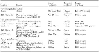
Table 1. Sources of remotely sensed data for epidemiological applications
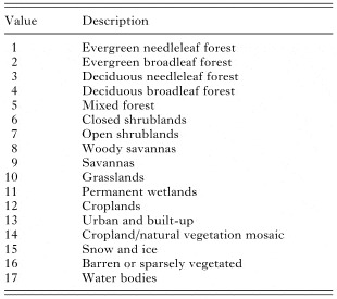
Table 2. IGBP land cover classes
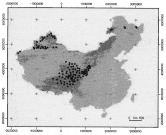
Fig. 1. Spatial correlation of counties with human AE cases (black points) in China and grassland land cover (dark grey) from IGBP global land cover classification. Grid system is Universal Transverse Mercator (metres) referenced to an origin in zone 47 N.
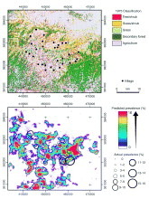
Fig. 2. Land cover map of Zhang study area, south Gansu, with observed AE prevalence and predicted AE prevalence from logistic regression Model 2.
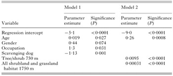
Table 3. Logistic regression model results
 You have
Access
- 49
- Cited by