Over the last 50 years, a specific set of theoretical perspectives developed in the biological sciences has dominated archaeological research on mobile or nonagricultural subsistence strategies. This research draws primarily on human behavioral ecology and more recently on niche construction theory to investigate human-environment relationships following the adoption or development of domesticated plants and animals. While practitioners debate the utility of these perspectives (Codding and Bird Reference Codding and Bird2015; Gremillion, Barton, and Piperno Reference Gremillion, Barton and Piperno2014; Smith Reference Smith2015; Zeanah Reference Zeanah2017; Zeder Reference Zeder2012, Reference Zeder2015a) or attempt to engage with both frameworks (Mohlenhoff, Brenner, and Codding Reference Mohlenhoff, Brenner and Codding2015; Steiner and Kuhn Reference Steiner and Kuhn2016; however, see Zeder Reference Zeder2014, Reference Zeder2015b), recent complementary research highlights how anthropogenic and natural environmental disturbance factors can influence the long-term trajectory of farming and foraging practices (Bird, Bliege Bird, and Codding Reference Bird, Bird and Codding2016; Bliege Bird Reference Bliege Bird2015; Codding et al. Reference Codding, Bird, Kauhanen and Bird2014; Lightfoot et al. Reference Lightfoot, Cuthrell, Striplen and Hylkema2013). Furthermore, both perspectives also identify risk as a significant factor influencing the decision-making of farmers and foragers (Kelly Reference Kelly2013:68–69; Winterhalder and Kennet Reference Winterhalder, Kennett, Winterhalder and Kennett2006; Zeder Reference Zeder2012:251).
This article identifies the relationship between disturbance, risk, and Archaic period foodways through the analysis of more than 70,000 identified macrobotanical remains collected from archaeological features at the Las Capas site, located in the Tucson Basin of southeastern Arizona (Figure 1). Macrobotanical data are interpreted in concert with data derived from geoarchaeological and geochemical investigations of agricultural systems and soils. The analysis of these data reveals diachronic trends in plant food diversity with implications for long-term stability and change in food production, collection, and consumption practices by community members at Las Capas. Theoretical ecological frameworks developed to identify diversity-disturbance relationships provide clear and testable expectations for the archaeobotanical assemblage. The results indicate that moderate-intensity disturbance events limited the productivity of food production systems and promoted greater short-term ecological and dietary diversity, expectations that are best interpreted using the ecological frameworks of the “Intermediate Disturbance Hypothesis” and the “Intermediate Productivity Hypothesis.” Such moderate-intensity disturbance events can serve as a partial barrier to the adoption of more productive yet unsustainable food production practices and provide subsequent generations with the flexibility necessary to overcome future disturbances (Marston Reference Marston2015). Due to the constrained chronology of the occupation and its high-resolution identification via radiocarbon dating, it is possible to empirically track the dynamic relationships among people, plants, and environmental disturbance at Las Capas through time and consider the implications for the resilience of food production systems.
Location of the Tucson Basin in the US Southwest and the location of the Las Capas site within the Tucson Basin.

A Global Context for Late Archaic Foodways
In a pattern similar to that for early food-producing societies worldwide (Smith Reference Smith2001:25; Zeder Reference Zeder2012:248–249), researchers in the US Southwest and northwestern Mexico have noted a roughly 2,500-year period of low-level food production with domesticates dating from the arrival of maize prior to 2100 BC,Footnote 1 until the manifestation of sedentary villages between roughly AD 400 and 750. Following Smith (Reference Smith2001), low-level food-producing societies inhabit the extensive area between foraging and intensive agriculture and may or may not use domesticated plants. Although archaeologists working in southern Arizona and northwestern Mexico have referred to the 2100 BC–AD 50 interval as the “Early Agricultural period” in lieu of the “Late Archaic,” Smith's (Reference Smith2001) framework requires a “fuzzy” threshold of 30%–50% reliance on domesticated plants to be an “agricultural” society. Therefore, referring to all groups that used maize during this interval as “early agricultural” glosses over those groups that were not strictly agricultural but invested in “low-level” food production either with or without the aid of domesticates (Smith Reference Smith2001:27). Regardless, during this period some farmer-foragers built irrigation systems to increase crop yields yet consistently relied on a wide variety of wild plants.
Several lines of evidence indicate that the structure of Late Archaic foodways cannot be completely attributed to commonly cited large-scale processes such as population pressure, the limited productivity of early cultigens, and the lack of functional ceramics. For example, heavy reliance on a wide range of small-seeded annual plants began during the Middle Archaic (3500–2100 BC; Roth and DeMaio Reference Roth and DeMaio2014; Roth and Freeman Reference Roth and Freeman2008) and increased dramatically with the adoption of maize during the Late Archaic (Supplemental Table 1), but continued even following the widespread use of ceramics and more productive maize varieties in southern Arizona between AD 50 and 700 (Diehl Reference Diehl and Wallace2003:285; Huckell Reference Huckell and Mabry1998:128–129). In addition, recent demographic reconstructions demonstrate that sustained population growth did not occur in the Sonoran Desert until roughly AD 500–1000 (Kohler and Reese Reference Kohler and Reese2014:10102), and human remains from Late Archaic contexts do not exhibit food-related stress pathologies (Watson Reference Watson2011; Watson and Byrd Reference Watson, Byrd and Vint2015). Furthermore, during the San Pedro phase (1220–730 BC) farmer-foragers did not have a negative impact on agricultural soils or local fauna even in the most densely occupied areas (Homburg Reference Homburg, Vint and Nials2015:224; Macphail Reference Macphail, Vint and Nials2015:153; Waters, Reyes, and Wolff Reference Waters, Reyes, Wolff and James2015:301). There is, however, evidence for conflict identifiable through skeletal trauma (Watson Reference Watson2011; Watson and Byrd Reference Watson, Byrd and Vint2015), which may indicate competition over resources regardless of population pressure (Watson and Phelps Reference Watson and Phelps2016).
Diversity, Resilience, and Ecological Theory
Diversity, here defined as the abundance of individuals distributed across a number of different observed categories (Maurer and McGill Reference Maurer, McGill, Magurran and McGill2011), is often invoked in archaeological research that examines large-scale social and environmental change (Hegmon et al. Reference Hegmon, Freeman, Kintigh, Nelson, Oas, Peeples and Torvinen2016; Nelson et al. Reference Nelson, Hegmon, Kulow, Peeples, Kintigh and Kinzig2011). Despite increasing attention to the role of diversity in these processes, archaeologists have not overtly investigated how the scale and scope of disturbance events, which are critical components of creating and maintaining diversity (Folke et al. Reference Folke, Carpenter, Walker, Scheffer, Elmqvist, Gunderson and Holling2004:571), impacted the resilience of socioenvironmental systems. In contrast, ecologists have frameworks that identify the parameters and outcomes of diversity-disturbance relationships (DDRs) among a range of plant, animal, and microbial organisms (Connell Reference Connell1978; Huston Reference Huston1979, Reference Huston2014; Sheil and Burslem Reference Sheil and Burslem2013). These frameworks supply explicit expectations as to how individual responses to discrete disturbance events influence the trajectories, in aggregate, of diversity within groups (for reviews, see Hughes et al. Reference Hughes, Byrnes, Kimbro and Stachowicz2007; Huston Reference Huston2014; Kershaw and Mallik Reference Kershaw and Mallik2013; Miller, Roxburgh, and Shea Reference Miller, Roxburgh and Shea2011). In this article, resilience is defined as the ability of a system to absorb disturbance and maintain similar function and structure (Walker et al. Reference Walker, Gunderson, Kinzig, Folke, Carpenter and Schultz2006), and disturbance is defined as any discrete anthropogenic, or nonanthropogenic, environmental, climatological, or geologic event that changes resource availability and/or alters the structure of a biological system or community (Picket and White Reference Picket and White1985).
Two of the most influential, and at the same time contested, DDRs used in ecology have been the Intermediate Disturbance Hypothesis (IDH) and the Intermediate Productivity Hypothesis (IPH). The IDH predicts that frequent and/or intense disturbance will suppress diversity in low-productivity environments (Figure 2a), while infrequent and/or less intense disturbance will promote the dominance of a limited range of species in high-productivity environments (Figure 2b). Moderate intensity and/or frequent disturbance in intermediate productivity environments is expected to promote maximum diversity, resulting in what is known as the unimodal or “single-humped” model (Figure 2c; Catford et al. Reference Catford, Daehler, Murphy, Sheppard, Hardesty, Westcott, Rejmánek, Bellingham, Pergl, Horvitz and Hulme2012; Miller, Roxburgh, and Shea Reference Miller, Roxburgh and Shea2011:5643). In turn, the IPH predicts unimodal diversity patterns in response to intermediate disturbance only when productivity is also intermediate (Huston Reference Huston2014:2383). When productivity is low, less intense disturbance is expected to promote diversity (Figure 2d), and when productivity is high, greater-intensity disturbance is expected to produce maximum diversity (Figure 2e).
(a–f) Predicted relationships between diversity and disturbance under different productivity and disturbance regimes. The Intermediate Disturbance Hypothesis (IDH) occurs when disturbance is intermediate on a gradient in conditions of intermediate productivity. The Intermediate Productivity Hypothesis (IPH) occurs when productivity is intermediate on a gradient in conditions of intermediate disturbance (i.e., mortality). Both are characterized by a unimodal or “single-humped” model. (Adapted from Huston Reference Huston2014:2384, Figure 1D.)

Ecologists (Miller and Chesson Reference Miller and Chesson2009) and archaeologists (Hegmon et al. Reference Hegmon, Peeples, Kinzig, Kulow, Meegan and Nelson2008; Hegmon et al. Reference Hegmon, Freeman, Kintigh, Nelson, Oas, Peeples and Torvinen2016) view such diversity as a primary factor influencing the resilience of biological and socioecological systems, and so the identification of disturbance events via a DDR framework is critical to archaeological studies of human-environment relationships. However, in addition to nonanthropogenic environmental variables, anthropologists must also consider the dynamic relationship between disturbance, productivity, and diversity within the context of landscapes that are constructed, managed, and manipulated by people for generations. Building on this, some anthropologists have recognized the potential for the IDH to address human-environment interactions (Baleè Reference Baleè2006:83; Bliege Bird Reference Bliege Bird2015: 243–245; Codding et al. Reference Codding, Bird, Kauhanen and Bird2014; Smith and Wishnie Reference Smith and Wishnie2000). For example, researchers have recently argued that intermediate levels of anthropogenic disturbance caused by Martu hunters in Australia (Bliege Bird et al. Reference Bliege Bird, Nyalangaka, Codding and Bird2013) and Miskitu farmer-foragers in Honduras (Dunn, Estrada, and Smith Reference Dunn, Estrada and Smith2012) increase the diversity and patchiness of ecological communities and contribute to the reliability and sustainability of subsistence strategies.
Although ecologists debate the use of the IDH and the IPH as explanatory frameworks (Fox Reference Fox2013; Huston Reference Huston2014; Sheil and Burslem Reference Sheil and Burslem2013), recent research has identified the IDH as the most accurate predictor of DDRs in plants (Kershaw and Mallik Reference Kershaw and Mallik2013; Mackey and Currie Reference Mackey and Currie2001). Huston (Reference Huston2014:2383) has found that while certain critiques of the manner in which ecologists have employed the IDH and IPH are valid, particularly their early unclear reliance on verbal rather than mathematical models for prediction building, there is still enough empirical validation of the IDH and IPH through field and experimental studies to warrant their use. Ecologists argue that the specific mechanisms that drive IDH/IPH-like diversity in ecological contexts are plant mortality and latent soil productivity. This is because productivity is directly tied to population growth rates (Huston Reference Huston2014:2384), and in an agro-ecosystemic context, growth rates are linked to soil fertility and moisture. Huston has further specified plant mortality to be “(plant) mortality causing events” (2014:2383), which in this article are referred to as disturbance more broadly, since disturbance events affect plant mortality either through external environmental perturbation or through changes in plant harvesting within an agro-ecosystemic context. Building on this framework, we propose a model that identifies the mechanisms expected to drive diversity in plant communities and Late Archaic foodways that considers the relationship between productivity and disturbance within the context of the Las Capas agro-ecosystem.
The Las Capas Site in a Regional Context
Although maize arrived in the Southwest before 2100 BC, archaeologists debate whether maize was incorporated into the existing hunter-gatherer economy with a minimal impact (Minnis Reference Minnis and Ford1992; Wills Reference Wills, Price and Gebauer1995) or a moderate impact (Diehl and Waters Reference Diehl, Waters, Winterhalder and Kennett2006) or quickly became a dietary staple (Coltrain, Janetski, and Carlyle Reference Coltrain, Janetski and Carlyle2007; Hard et al. Reference Hard, Adams, Roney, Schmidt, Fritz, Reitz, Scarry and Scudder2008). Despite the disagreement, paleoethnobotanists concur that early maize varieties were not as productive as those grown later in the prehispanic era (Adams Reference Adams, Johannessen and Hastorf1994; Diehl Reference Diehl2005a; Huckell Reference Huckell, Staller, Tykot and Benz2006), and recent research suggests that maize was quickly and intensively adopted by some groups but only casually adopted by others (McBrinn Reference McBrinn2010:303–306; Roth Reference Roth2016). The Las Capas site contains the most thoroughly documented preceramic evidence of increasing investment in maize cultivation in the Southwest. Las Capas covers roughly 0.8 km2 and was used between 1500 and 400 BC, but was intensively and likely continuously inhabited between 1220 and 730 BC by a group of roughly 80–250 relatively mobile low-level food producers (Mabry Reference Mabry and Mabry2008:57–58; Mabry et al. Reference Mabry, Holmlund, Nials, Palacios-Fest and Mabry2008:241–245; Vint Reference Vint and Vint2015:27; Whittlesey, Foster, and Mitchell Reference Whittlesey, Foster, Mitchell, Whittlesey, Hesse and Foster2010:80). Archaeologists have excavated more than 5,000 cultural features at the site, ranging from domestic structures to extramural cooking and storage features. Excavated, mapped, and analyzed ancient agricultural field systems include canals, field cells, and even individual planting pits (Figure 3). Analyses of paleoethnobotanical remains from more than 1,300 cultural features (Diehl Reference Diehl and Diehl2005b, Reference Diehl and Vint2015; Sinensky Reference Sinensky2013), totaling nearly 6,900 L of archaeological sediment, provide a high-resolution record of human-environment interactions during the Late Archaic period, and thus the Las Capas site is an ideal case study to assess the efficacy of the IDH and IPH in an archaeological context.
Terminal San Pedro phase (800–730 BC) fields from the 2008–2009 excavations at the Las Capas site. Berms separating individual fields and berms serving as borders along lateral canals are highlighted in white. (Courtesy of James Vint, Desert Archaeology, Inc.)

Climate, Chronology, and the Environmental Context of the Las Capas Site
Las Capas is one of many Late Archaic sites located in the floodplain of the Santa Cruz River in the Tucson Basin. Abundant riparian and floodplain resources were available locally at an elevation of about 750 m asl, while bajada (750–1,400 m asl) and mountain (1,400–2,800 m asl) plants were available within 20 km of the site. A variety of geologic and hydrologic factors contributed to Las Capas being one of only several locations with reliable perennial surface water in the Tucson Basin (Nials, Gregory, and Hill Reference Nials, Gregory and Hill2011:737). Access to water was one of the primary limiting factors for agriculture in the Sonoran Desert, and the earliest evidence for habitation at Las Capas dates to a stable interval of extended aridity between 1220 and 1000 BC. Community members invested in irrigation infrastructure such as canals to increase crop yields, but the site was still susceptible to destructive flood events due to its proximity to the Santa Cruz River.
The rapid pace of overbank flood deposits and intensive/continuous site occupation has facilitated the development of a detailed chronology of the San Pedro phase occupation (Figure 4). The stratum designations developed by Nials (Reference Nials and Mabry2008, Reference Nials, Vint and Nials2015a), as well as the chronology developed by Vint (Reference Vint and Vint2015), are used throughout the discussion below, with the most recent strata given the lowest numeric designation (e.g., Stratum 504).Footnote 2 Following this chronology, Stratum 506 consists of a stable floodplain deposit that dates between 1220 and 1000 BC, the Initial San Pedro (ISP) phase. Floodplain conditions during the deposition of Stratum 505 (930–800 BC), the Middle San Pedro (MSP) phase, were characterized by alternating periods of rapid deposition and erosion due to multiple intense flood events triggered by heavy upstream erosion (Nials Reference Nials and Mabry2008:50, Reference Nials, Vint and Nials2015a:58, Reference Nials and Vint2015b:468). These events likely scoured the latter portions of Stratum 506 and removed the 1000–930 BC stratigraphic interval (Vint Reference Vint and Vint2015:25). Although Stratum 505 was previously considered “culturally sterile” (Mabry Reference Mabry and Mabry2008:55), recent excavations identified a variety of cultural features indicating that the site was continuously occupied through this period of instability. Stratum 504 (800–730 BC), the Terminal San Pedro (TSP) phase, is characterized by regular low-impact overbank flood events (Nials Reference Nials and Mabry2008:50), and the time that it represents coincided with a period of reliable precipitation. Each stratum contains a similar range of archaeological features, including irrigation canals, domestic structures, and large bell-shaped storage pits. The termination of the San Pedro phase occupation coincided with the deposition of Stratum 503 in roughly 730 BC, a large flood event that inundated the floodplain with an enormous quantity of coarse alluvial material that ultimately led to the site's abandonment.
Stratigraphy and chronology of the San Pedro phase occupation of the Las Capas site.

Methods and Expected Trends
The effect of the numerous intermittent nonanthropogenic flood events at Las Capas can be modeled by DDRs, which provide a series of expectations for plant diversity. However, accurately gauging the response of local plant communities to different degrees of disturbance requires an assessment of productivity and the intensity of disturbance events. Since Las Capas community members constructed, modified, and maintained a stable anthropogenic landscape for roughly 500 years, and the agro-ecosystem revolved around maize production,Footnote 3 expectations for productivity are developed from geoarchaeological analyses of agricultural soils and agricultural features (Homburg Reference Homburg, Vint and Nials2015; Nials Reference Nials and Mabry2008, Reference Nials, Vint and Nials2015a, Reference Nials and Vint2015b) and are then tested against archaeobotanical data. The intensity of flood events is measured using diachronic studies of floodplain geomorphology and by assessing the degree to which disturbances impacted agricultural features.
Productivity and Disturbance at Las Capas
The well-preserved canals, fields, and even individual planting pits at Las Capas provide an extensive record of preceramic agricultural systems and soils. Homburg (Reference Homburg, Vint and Nials2015) has analyzed nearly 300 soil samples from these agricultural fields to gauge soil productivity and concludes that conditions were sufficient for maize farming throughout the San Pedro phase. However, in arid and semiarid environments such as southern Arizona, access to moisture also influences productivity. Local precipitation patterns reconstructed from regional tree ring records and on-site geomorphology indicate that precipitation was predictable during the ISP and TSP (Nials Reference Nials, Vint and Nials2015a:44, 61) which produced low-intensity overbank flood events and provided crucial water for irrigation at regular intervals. However, precipitation was intense and erratic during the MSP, which impacted the reliability of irrigation water (Nials Reference Nials and Mabry2008:50, Nials Reference Nials, Vint and Nials2015a:58).
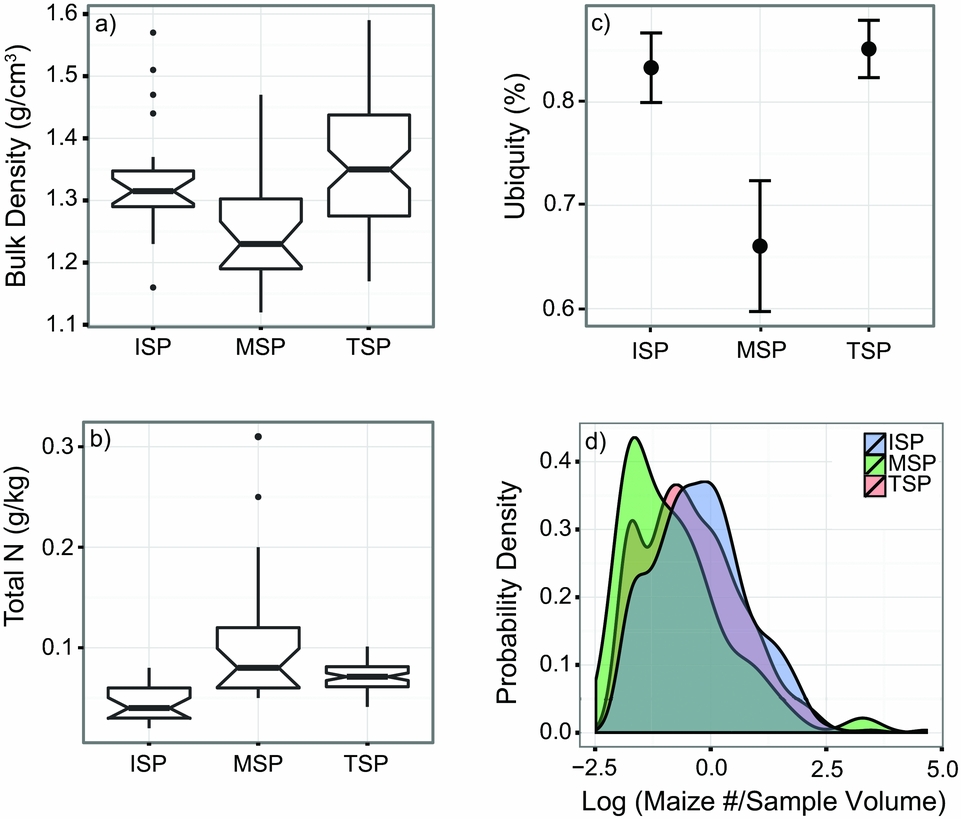
Analyses of irrigation features and agricultural soils demonstrate that more intensive cultivation took place when rainfall was reliable. For example, elevated levels of soil salinity only occurred in ISP and TSP fields, which may indicate more intensive irrigation (Homburg Reference Homburg, Vint and Nials2015:217). Soil bulk density, a measure of soil compaction attributable to the intensity and frequency of the application of irrigation water to individual fields, was lowest during the MSP and greatest during the TSP (Figure 5a). The concentration of nitrogen in the soils of agricultural fields, however, increased sharply following the transition to the MSP (Figure 5b). While this illustrates that soils were potentially more productive during the MSP, this pattern is also expected when fields are left fallow or are less intensively cultivated.
Agricultural soils data and maize measures from Initial San Pedro (ISP, 1220–1000 BC), Middle San Pedro (MSP, 930–800 BC), and Terminal San Pedro (TSP, 800–730 BC) contexts: (a) mean bulk density of agricultural soils, which is directly related to the intensity and frequency at which irrigation water was applied to fields; (b) total available nitrogen content of agricultural soils through time; (c) mean maize ubiquity, with 95% confidence intervals derived from an exact binomial distribution; (d) log-transformed maize densities per stratum. The log calculation excluded 248 samples that contained no maize.

One reason that fields may have been less intensively cultivated during the MSP involves several closely spaced and relatively heavy flood events. In contrast to all other floods that occurred between 1220 and 730 BC, the MSP floods caused changes to local topography and hydrology (Nials Reference Nials, Vint and Nials2015a:58) and limited the community's ability to ensure that the built environment provided maize plants with a competitive advantage. For instance, geoarchaeological investigations of the construction, use, and upkeep of canals shows that several generations of MSP canals were inundated with flood deposits and quickly abandoned, and in one case, a canal was abandoned before it was used (Nials Reference Nials, Vint and Nials2015a:50, 60). These canals were small and do not show evidence of long-term use or maintenance. However, despite these frequent MSP flood events, communities continued living at Las Capas and investing in irrigation infrastructure, which attests to a degree of success in this water management strategy. In contrast, canals were abundant, intensively used, and thoroughly maintained during the ISP (Nials Reference Nials, Vint and Nials2015a:55) and were larger, more abundant, and more intensively used and maintained during the TSP (Nials Reference Nials, Vint and Nials2015a: 63–64).
Therefore, the available evidence demonstrates that the highest levels of latent productivity occurred during the ISP and TSP, while erratic precipitation during the MSP most likely supported intermediate productivity. Since the MSP floods were more frequent and more intense than the predictable overbank floods that occurred during the ISP and TSP, but far less intense than the single massive flood at the end of the TSP, the MSP floods are considered intermediate disturbance events. Differences in how community members responded to floods also support the aforementioned characterization of disturbance events. Community members responded to low-intensity floods during the ISP and TSP by maintaining canals, responded to the intermediate flood events by abandoning inundated features and constructing new canals, and responded to the single flood event at the end of the TSP by ceasing to occupy Las Capas after nearly 20 generations.
Expectations for Diversity and Productivity
Drawing on the IDH and IPH, plant communities during the MSP are expected to have diversified in response to intermediate disturbance (Figure 6). While one of the ultimate causes of fluctuations in plant diversity detectable in the archaeobotanical record will be due to the intermediate disturbance of the flood events, the proximate mechanisms that increased plant diversity in each time period are more difficult to ascertain. The influence of the intermediate flood events on local plant communities, moreover, was itself shaped by nearly 10 generations of farmers who manipulated floodplain conditions. Within this managed agro-ecosystem, the MSP floods would have depressed maize yields through field destruction, as the geoarchaeological evidence above shows, but they also would have increased the diversity of small-seeded ruderal plants, which thrive in fallow fields. As maize yields declined, Las Capas community members may have diversified their food production and foraging practices as a risk management strategy (Marston Reference Marston2011; VanDerwarker, Marcoux, and Hollenbach Reference VanDerwarker, Marcoux and Hollenbach2013). Therefore, any diversity detectable in the archaeobotanical record could indicate either an absolute increase of different resources available to the community with a congruent change in diet, a change in more diverse harvesting and foraging practices independent of plant type abundance, or both. Neither mechanism is mutually exclusive, although neither possibility can be excluded at the moment.
Hypothesized relationships among productivity, disturbance, plant biodiversity, dietary diversity, and risk management at Las Capas. The diversity-disturbance relationship (DDR) known as the Intermediate Disturbance Hypothesis (IDH) is expected during the Middle San Pedro since productivity and disturbance intensity are both argued to have been intermediate.

First, we identify broad patterns in the archaeobotanical data that document the influence of variable environmental conditions on maize productivity and ecological diversity within the agro-ecosystem. Then, we assess how community members, in aggregate, responded through a focus on the changing use of plant taxa. We evaluate the diversity of plant taxa using richness and diversity indices developed in ecology and biology (Magurran Reference Magurran2004).
Field Collection and Analysis Methods
The data used to address these model expectations were derived from samples of archaeological sediments processed via flotation and collected from cultural features by Desert Archaeology in 1998 and 2008–2009. Archaeological plant remains were collected from a variety of intramural and extramural contexts. Information on processing and identification procedures can be found in Diehl (Reference Diehl2005a, Reference Diehl and Vint2015) and Sinensky (Reference Sinensky2013). Sediment samples were processed in a Flote-Tech machine. Light fractions were sorted using nested 2.0-mm, 1.0-mm, and 0.5-mm geologic screens. Data used in these analyses are available in Supplemental Table 2 and Supplemental Table 3, and the “R” code used to create the figures is available in Supplemental Text 1. Strategies used to integrate and operationalize the data are described in Supplemental Text 2. In total, 2,391 L from 474 samples yielding 15,492 specimens were analyzed from ISP contexts, 1,138 L from 217 samples yielding 16,233 specimens were analyzed from MSP contexts, and 3,345 L from 633 samples yielding 39,099 specimens were analyzed from TSP contexts (Table 1).
Flotation Sample Information, Zea mays Quantitative Measures, and Mean Diversity.

Note: ISP = Initial San Pedro (1220–1000 BC); MSP = Middle San Pedro (930–800 BC); TSP = Terminal San Pedro (800–730 BC).
a Does not include seven extreme outliers with maize counts greater than 80.
b Kernel-to-cupule index only includes samples with available “specimen part” data. This includes 87 samples from the ISP, 45 samples from the MSP, and 355 samples from the TSP.
Intermediate Disturbance, Food Production, and Shifting and Routine Practices
Analyses of the macrobotanical data show that the productivity of the Las Capas agro-ecosystem was high during the ISP and TSP but intermediate during the MSP. Maize ubiquities (proportional presence across samples) are high during the ISP and are well above the values of all other plant resources (Figure 5c; Supplemental Table 4). However, maize ubiquities decline and are lower than preferentially cultivated and collected ruderal plants during the following MSP. During the TSP, maize ubiquities return to high levels and are again higher than ubiquities of all other plant resources. Maize density (number of specimens per analyzed liter of sediment) values suggest a similar pattern, with a high density during the ISP and TSP and lower values during the MSP (Figure 5d). In summary, paleoclimate proxies, studies of agricultural soils, canal systems, and macrobotanical data show that the intermediate flood events had a notable impact on food production but community members continued farming on the floodplain.
Diversity in Response to Disturbance
Two diversity measures were calculated from the macrobotanical data to test the empirical prediction of the IDH, namely, the increased diversity of botanical resources after moderate disturbance. There are numerous indices with which diversity might be calculated. Richness (S), which measures the number of different species or taxonomic categories present within a sampled population (Magurran Reference Magurran2004:76), is one of the most common indices and is highly correlated with the number of identified specimens in archaeobotanical (Lepofsky and Lertzman Reference Lepofsky and Lertzman2005), archaeological (Kintigh Reference Kintigh1984), and ecological assemblages (Magurran Reference Magurran2004:74–84). Therefore, statistical methods are necessary to control for differences in the number of identified botanical specimens between strata. For sample-based assemblages, like those in archaeobotanical research, methods must adjust not only for the number of samples but also for sample volumes.
We mitigate the effect of sample size through “sample-based rarefaction,” a resampling x times with replacement of a pool of n samples, at random, with the average number of species plotted against N samples or individuals. Sample-based rarefaction reduces the heterogeneity introduced by the varying numbers of individuals in samples of different volumes through resampling. However, despite being sample-based, all analyses focused on species richness must ultimately compare the number of species against the number of individuals (Gotelli and Collwell Reference Gotelli and Colwell2001:382). In contrast, if the object of analysis is species density, then a comparison of the number of samples with the average expected richness should be used (Colwell, Mao, and Chang Reference Colwell, Mao and Chang2004). The sample-based rarefaction employed in this article weights the expected richness per sample by “sampling effort,” which here is an adjustment for different flotation volume sizes. Therefore the species richness presented below is more properly a species density per sample (per stratum) adjusted for equivalent quantities of sampled sediment. The analysis of species richness was conducted in the program “R” (R Core Team 2013), primarily using the vegan package (Oksanen et al. Reference Oksanen, Blanchet, O'Hara, Simpson, Solymos, Henry, Stevens, Szoecs and Wagner2016).
The Simpson's Index (D) identified changes in the diversity of Las Capas plant foods (Magurran Reference Magurran2004:115). The index computes the sum of the squared proportional abundance of individuals (p 2i) across a set of taxa and in the current article is expressed as the inverse (1/D) to place it on a scale such that larger numbers imply a greater amount of diversity, that is, less dominance by any set group of taxa. The inverse for Simpson's Index, used in these calculations, is displayed below (Maurer and McGill Reference Maurer, McGill, Magurran and McGill2011:56). Evenness (E) is derived from dividing the index by total species richness (S). A sample-based rarefaction using the inverse Simpson's Index was calculated using the freely available software EstimateS (Colwell Reference Colwell2013), again to control for differences in sample size (and the number of identified specimens) between strata (Supplemental Table 3):
 $$\begin{equation}
{D_{Simpson}} = \frac{1}{{\sum p_i^2}}
\end{equation}$$
 $$\begin{equation}
E = \frac{{{D_{Simpson}}}}{S}
\end{equation}$$
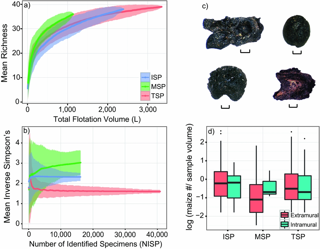
The results of the modified sample-based rarefaction indicate that Las Capas inhabitants relied on a restricted number of taxa during the ISP, on a wider variety of resources following moderate disturbance during the MSP, and then returned to a more restricted strategy during the TSP (Figure 7a). However, the rarefaction curves for the ISP and MSP do not reach an asymptote and as a result have not reached a species saturation point, and so further sampling effort could yield different curves (Gotelli and Colwell Reference Gotelli and Colwell2001:388). The inverse Simpson's Index also illustrates that assemblage diversity is highest during the MSP and reaches its lowest level in the TSP (Figure 7b). Overall, these diversity measures present clear evidence of considerable directional change in plant use following the intermediate flood events. The fact that these changes track other archaeobotanical and geoarchaeological measures of maize productivity suggests a broader food procurement strategy in response to the greater risk and uncertainty associated with floodplain farming during the MSP, but the particular ways that community members used these resources reflect local decision making in response to such changes. While increasing diversity in the archaeobotanical assemblage in part reflects the aforementioned greater diversity in floodplain plant communities predicted by the IDH, it is not strictly necessary that dietary change is congruent with plant community diversity (Figure 6). The specific responses of the Las Capas communities to increased plant diversity would have been mediated through decision making in routine cultivation and collection practices, which are identifiable in the macrobotanical assemblage.
Diversity measures and intramural/extramural maize density measures. (a) Species accumulation curve based on a “random” rarefaction method (Gotelli and Colwell Reference Gotelli and Colwell2001) comparing mean richness values with the amount of sampling effort, which here is represented as the total quantity of sampled sediment per stratum. Shaded areas represent 95% confidence intervals. (b) Sample-based rarefaction using mean inverse Simpson's Index values. Shaded areas represent two standard deviations from the mean, which are used to approximate confidence intervals. (c) Carbonized maize cob parts and kernels from Middle San Pedro phase (930–800 BC) contexts at Las Capas. All scales equal 1 mm. (d) Log-transformed maize densities by stratum from intramural and extramural feature contexts dating to the Initial San Pedro (ISP, 1220–1000 BC), the Middle San Pedro (MSP, 930–800 BC), and Terminal San Pedro (TSP, 800–730).

Changing Routine Cultivation Practices
Although plant remains uncovered from a single feature usually represent the aggregation of a number of discrete events, fluctuating resource ubiquity and density is indicative of changing daily plant procurement and processing (van der Veen Reference van der Veen2007). We can see such changes in the relative proportions of taxa present in flotation samples collected from intramural and extramural contexts. Maize density is roughly equivalent on average across strata in intramural contexts, although the MSP sample is small (Table 1; Figure 7d). This suggests that maize at Las Capas was processed, stored, or used for fuel in a similar fashion within domestic structures over time. Conversely, maize density and ubiquity are considerably lower in extramural contexts during the MSP, and this change suggests a shift in maize processing practices.
This change is seen in the ratio of maize kernels to cupules over time. Lower kernel-to-cupule ratios are evidence of processing activities such as dehusking and shelling, while higher kernel-to-cupule ratios are evidence of consumption (Scarry and Steponaitis Reference Scarry, Steponaitis and Gremillion1997; Turkon Reference Turkon2004:236; VanDerwarker Reference VanDerwarker2006:102–106). In arid regions worldwide, crop by-products, including maize cobs, are typically burned for fuel (Miksicek Reference Miksicek1987:227; Rocek Reference Rocek1995:230; van der Veen Reference van der Veen1999), while charred grains more likely represent consumption events. MSP contexts contain a much greater kernel-to-cupule ratio compared with ISP and TSP deposits (Table 1). This may indicate that productive fields were located a greater distance from the Las Capas site during the MSP and that crops were processed at a distance from the site to reduce transport costs. The change in kernel-to-cupule ratios and evidence for decreasing investment in irrigation infrastructure suggest spatial diversification as a risk management strategy (Goland Reference Goland1993; Marston Reference Marston2011; Stone and Downum Reference Stone and Downum1999). Floodplain irrigation was likely one of several farming strategies practiced by community members, and when the risk posed by sporadic rainfall and the intermediate flood events was recognized, inhabitants may have redirected their labor to, for example, farming the mouths of alluvial fans and ephemeral streams (Bryan Reference Bryan1929; Mabry Reference Mabry and Diehl2005; Nabhan Reference Nabhan1979). While the increasing importance of non-irrigation farming likely encouraged community members to invest in a spatially diverse food production strategy, discrete changes to how people collected, processed, and stored foraged foods during the MSP also had implications for the resilience of Late Archaic foodways.
Shifting Routine Foraging Practices
In addition to a spatial diversification of farming practices, archaeobotanical data also provide evidence for changing foraging practices at Las Capas. Quantitative measures suggest that community members responded to the changing structure of floodplain plant ecology by harvesting larger quantities of certain types of ruderals. While the ubiquity of the most economically significant ruderal taxa such as Chenopodium sp. and Amaranthus sp. (Cheno-ams) remains high throughout the San Pedro phase (Figure 8a), the ubiquity and density of dispersed ruderal plants (Figure 8b) and the density of wild grasses (Supplemental Table 4) increase dramatically during the MSP. This suggests that dispersed ruderal plants were more intensively culled to limit competition with maize during the ISP and TSP but were permitted to grow to maturity during the MSP.
Mean plant group ubiquities with confidence intervals derived from an exact binomial distribution from Initial San Pedro (ISP, 1220–1000 BC), Middle San Pedro (MSP, 930–800 BC), and Terminal San Pedro (TSP, 800–730 BC) cultural features: (a) carbonized Chenopodium sp. seed and Chenopodium sp. bract; (b) carbonized Polygonum sp. (knotweed) seeds; (c) carbonized Carnegiea gigantea (saguaro cactus) seeds. All scales equal 1 mm.

Trends in the macrobotanical data also reveal a prominent shift in the procurement and processing of reliable and economically significant foraged plants that were only available in significant quantities by venturing from the floodplain into upland areas. While cactus seeds are ubiquitous during the ISP, they are far less ubiquitous following the intermediate flood events and remain low following the MSP-to-TSP transition (Figure 8c). Furthermore, the primary locus of on-site cactus processing and consumption shifted from extramural contexts during the ISP to intramural contexts during the TSP (Figure 8c; Supplemental Table 4). Historically, indigenous mobile farmer-forager groups in southern Arizona relocated to upland camps to collect and process saguaro cactus (Carnegiea gigantea) fruit immediately before occupying summer farming villages (Castetter and Bell Reference Castetter and Bell1942:223–224; Crosswhite Reference Crosswhite1980). Lower cactus ubiquities, particularly in extramural contexts, may signal similar logistic moves to processing camps, while higher intramural ubiquities suggest that cactus fruits were increasingly stored or consumed within domestic spaces. Researchers have documented similar shifts in residential and logistic mobility as reliable risk management strategies employed by low-level food-producing societies worldwide (Marston Reference Marston2011:193; O'Shea Reference O'Shea, Halstead and O'Shea1989:62).
Discussion
A focus on the recursive relationship between diversity, productivity, and disturbance using well-established ecological theories provides a more integrated perspective on the changing makeup of plant communities within the Las Capas agro-ecosystem through time. Drawing on paleoclimatic proxies for precipitation, the geochemistry of agricultural soils, the construction and maintenance histories of canal systems, floodplain dynamics, and a robust archaeobotanical record, this article assessed the productivity and disturbance regime of coupled human-environment systems at Las Capas between 1220 and 730 BC. High productivity and low levels of disturbance during the ISP supported less diverse plant communities within the intensively managed agro-ecosystem. Unpredictable precipitation, intermediate disturbance, and changing land management practices by community members did not provide maize with the same competitive advantage during the MSP, and the modified landscape supported a more diverse plant community dominated by small-seeded ruderal plants. In response to declining maize productivity and the changing makeup of the agro-ecosystem, community members likely pursued spatially diversified farming practices and began harvesting greater quantities of dispersed ruderal plants and wild grasses. Routine processing and consumption practices associated with important nonfloodplain foods also changed, as community members increasingly processed/consumed cactus fruits in upland procurement areas. While changes in daily practice related to the production, procurement, and processing of domesticated and wild plants were most dramatic during the period of intermediate productivity and moderate disturbance (the MSP), several changes initiated during that time influenced routine practices even after productivity returned to predisturbance levels and diversity contracted. Two of the most prominent examples of this pattern are the continued harvesting of dispersed ruderal plants and wild grasses at quantities well above predisturbance levels during the TSP and changing cactus procurement, processing, and storage practices continuing into the TSP.
Broader Implications for Approaches to Modeling Past Socioenvironmental Relationships
While utilizing an IDH- and IPH-based perspective highlights the dynamic relationship between disturbance events, such as the intermediate flood events, and plant diversity, exploring the situated responses of societies to changing biodiversity requires pairing DDRs with a compatible theoretical framework. Although this article draws on resilience theory, DDRs such as the IDH and IPH hold promise for use alongside a range of theoretical approaches currently favored by archaeologists to explore human-environment relationships. For instance, without a focus on the dynamic relationship between productivity, diversity, and disturbance, dietary expansion during the MSP could have been attributed exclusively to a decline of the postencounter return rate of preferred resources, most notably maize. However, the legacy of nearly 10 generations of floodplain manipulation during the ISP and the initiation of the intermediate flood events increased the abundance of ruderal plants with a competitive advantage in the less intensively managed Las Capas agro-ecosystem. This would have shifted the postencounter return rate of small-seeded ruderal plants that were previously culled from maize fields. In this example, the benefits of ecological inheritance (sensu Odling-Smee and Laland Reference Odling-Smee and Laland2011) associated with generations of investment in floodplain farming could have persisted in spite of declining crop yields. This may in part explain why some community members remained at Las Capas during the MSP. The empirical foundations of this study provide a platform for future work that can utilize different perspectives, such as human behavioral ecology and niche construction theory, and more precisely determine the proximate decision-making mechanisms that led to changes in plant diversity and foodways.
Moreover, long before resilience theory concepts were incorporated into the ecologically oriented social sciences, anthropologists noted that many small-scale farming societies living in marginal environments practiced broad yet sustainable food production strategies focused on minimizing risk rather than maximizing food production (Netting Reference Netting1974:44, Reference Netting and Upham1990:39–40). Building on this foundational research, recent approaches highlight how environmental and anthropogenic disturbances shape and stabilize biological communities by encouraging biodiversity (Bliege Bird Reference Bliege Bird2015; Bliege Bird et al. Reference Bliege Bird, Nyalangaka, Codding and Bird2013; Dunn, Estrada, and Smith Reference Dunn, Estrada and Smith2012). This in turn increases the reliability and long-term resilience of socioenvironmental systems by minimizing the interannual variability of significant taxa and is particularly beneficial when societies maintain a broad diet (Bliege Bird Reference Bliege Bird2015). Regardless of whether community members at Las Capas recognized the consequences, greater floodplain biodiversity and subtle changes to routine cultivation and foraging practices encouraged by a legacy of landscape modification and episodic intermediate disturbance increased the resilience of food production systems. For example, since community members incorporated a broader range of small-seeded ruderal plants into their diet not only when maize productivity was reduced but also when maize yields were high, they reduced long-term risk, as these plants are expected to be present in the agro-ecosystem regardless of external factors that impact maize yields. Even when risk-averse practices initiated in response to intermediate disturbance did not persist, they still may have had implications for the resilience of food production strategies. For instance, although the spatially diversified farming practices noted in the MSP do not appear to have persisted into the TSP (Table 1), these practices likely contributed to higher nutrient levels noted in TSP agricultural soils. Since the IDH and IPH provide explicit expectations for the biodiversity of ecological communities under known productivity and disturbance regimes, they can also serve as powerful tools to identify whether coupled human-environment systems encouraged long-term diversity and minimized variability.
Conclusion
Diversity-disturbance relationships, including the Intermediate Disturbance Hypothesis, can highlight the dynamic relationship between disturbance and diversity in a wide range of past societies. Although the IDH and diversity measures used in this study were developed to explore biodiversity in plant communities, additional avenues of research in which the Intermediate Disturbance Hypothesis and Intermediate Productivity Hypothesis can be fruitfully employed include differing degrees of anthropogenic disturbances on plants, animals, and agricultural soils. The adoption of the empirical techniques used to identify DDRs such as the IDH and the IPH into the archaeological tool kit can provide additional rigor to assessments of the role of diversity in the resilience of past coupled human-environment systems. In this case, DDRs provided an opportunity to shift the focus from the stability of Late Archaic subsistence strategies to discrete changes to plant biodiversity in the Las Capas agro-ecosystem and shifting foodways in response to fluctuating risk. Taken as a whole, these DDRs provide greater context for observed changes to dietary diversity that did not change the underlying structure of Late Archaic foodways but nonetheless played a significant role in shaping short-term and long-term resilience. Risk-averse strategies adopted in response to episodic disturbance events may have contributed to the long-term resilience of Late Archaic foodways and may in part explain the persistence of societies engaged in low-level food production that maintained broad diet breadth for nearly 2,500 years in the Sonoran Desert of the southwestern United States and northwestern Mexico.
Acknowledgments
Archaeological research at Las Capas was made possible by funding provided by Pima County, Arizona. The 2008–2009 project was administered by the Tres Rios Reclamation Facility and the Pima County Office of Sustainability and Conservation, Cultural Resources and Historical Preservation Division. We would like to thank James Vint, Fred Nials, William Doelle, Veronica Perez-Rodriguez, Francis Smiley, Christian Downum, and Kelley Hays-Gilpin for their support. Additional thanks go to Karen Adams, Wolf Gumerman, and Mike Diehl for help with specimen identification. We thank Gregson Schachner and two anonymous reviewers for their thoughtful comments, which substantially increased the quality of this article.
Data Availability Statement
Data used in this analysis are available for download as supplements to this article. The soil chemistry data used to create Figure 5a–b are available in Homburg (Reference Homburg, Vint and Nials2015). For specific questions about these data and analyses, please contact R. J. Sinensky or Alan Farahani. Collections from the Las Capas site are curated at the Arizona State Museum in Tucson, Arizona.
Supplemental Materials
For supplementary material accompanying this paper, visit https://doi.org/10.1017/aaq.2017.74.
Supplemental Table 1. Ethnographic and Archaeological Evidence of Select Low-Return Plant Resources from Late Archaic Contexts in Southern Arizona and Northwestern Mexico.
Supplemental Table 2. Las Capas Flotation Data.
Supplemental Table 3. Las Capas “EstimateS” Output.
Supplemental Table 4. Mean Ubiquity, Descriptive Statistics, and Select Density Measures.
Supplemental Text 1. R Markdown Document with Code Used to Create Figures 5, 7, and 8.
Supplemental Text 2. Notes on Data of Supplemental Table 2.
Supplemental Text 3. References Cited in Supplemental Materials.