1. Introduction
This paper examines the nature of a low relief, low elevation area within the Zagros fold-and-thrust belt in Iran: the Dezful Embayment (Fig. 1). Together with the Kirkuk Embayment in Iraq, it contains many of the important oil and gas fields of the Middle East (Beydoun, Hughes Clarke & Stoneley, Reference Beydoun, Hughes Clarke, Stoneley, MacQueen and Leckie1992). However, despite over 100 years of exploration and production, aspects of the Dezful Embayment's structure and stratigraphy are not well understood. This study aims to improve our knowledge of the region, by integrating new observations from fieldwork and remote sensing with existing geological and seismicity datasets. We focus on the Balarud Line that forms the northern side of the Dezful Embayment, as its E–W orientation is unusual: most structures in this part of the Zagros trend NW–SE (e.g. Hessami, Koyi & Talbot, Reference Hessami, Koyi and Talbot2001). The origin and evolution of the Embayment cannot be understood without a wider perspective of the Zagros structure. Therefore, we also review the regional structure of the Zagros, with the specific aim of determining the broader structural variation and its causes and consequences.
(a) Location map and major structures of the Zagros Simply Folded Belt, Iran. Derived from National Iranian Oil Company (1975, 1977a, b), Berberian (Reference Berberian1995), Hessami, Koyi & Talbot (Reference Hessami, Koyi and Talbot2001), Blanc et al. (Reference Blanc, Allen, Inger and Hassani2003), Agard et al. (Reference Agard, Omrani, Jolivet and Mouthereau2005) and Babaie et al. (Reference Babaie, Babaei, Ghazi and Arvin2006). Key to fault abbreviations: B – Borazjan; Iz – Izeh; K – Kazerun; KB – Kareh Bas; Kh – Khanaqin; S – Sarvestan; SP – Sabz-Pushan; BL – Balarud Line; A – Kuh-e Asmari. (b) Location map for (a). CIM – Central Iranian microcontinent.

The Zagros Mountains are present for ~2000 km between eastern Turkey and SE Iran (Fig. 1). They are the geomorphic expression of the fold-and-thrust belt that is the deformed passive continental margin of the Arabian plate (Beydoun Hughes Clarke & Stoneley, Reference Beydoun, Hughes Clarke, Stoneley, MacQueen and Leckie1992; Alavi, Reference Alavi1994; Berberian, Reference Berberian1995). Deformation continues in the active Arabia–Eurasia collision zone. GPS-derived plate convergence vectors are roughly N–S (Sella, Dixon & Mao, Reference Sella, Dixon and Mao2002), and increase eastwards from 16 mm yr−1 at the apex of the Arabian promontory to 26 mm yr−1 in eastern Iran (Vernant et al. Reference Vernant, Nilforoushan, Hatzfeld, Abbassi, Vigny, Masson, Nankali, Martinod, Ashtiani, Bayer, Tavakoli and Chery2004). NW–SE-trending folds and thrusts in the NW Zagros combine with right-lateral strike-slip faulting along the Main Recent Fault (MRF) to produce the overall N–S convergence (Talebian & Jackson, Reference Talebian and Jackson2002); this spatial separation of plate convergence into thrust and strike-slip components is a good example of ‘strain partitioning’. In the east of the range (Fars region; Fig. 1) structures are more E–W trending, orthogonal to the plate convergence vector. There is no range-parallel strike-slip component in this region. Active shortening rates within the Zagros vary from 3 to 6 mm yr−1 in the western part of the range to 8 ± 2 mm yr−1 in the eastern part, determined from GPS campaigns within the range (Hessami, Nilforoushan & Talbot, Reference Hessami, Nilforoushan and Talbot2006; Walpersdorf et al. Reference Walpersdorf, Hatzfeld, Nankali, Tavakoli, Nilforoushan, Tatar, Vernant, Chery and Masson2006).
Several tectonic units are defined within the Zagros, although there is no universal agreement on boundaries and nomenclature. The Arabia–Eurasia suture is known as the Main Zagros Thrust (MZT), or Main Zagros Reverse Fault (MZRF), and lies at the northeastern side of the Zagros. It is adjacent to the High Zagros, which is the zone of highest elevations and deepest exposure levels: Cambrian and/or Upper Precambrian strata are exposed. The High Zagros is conventionally shown as being bounded to the southwest by the High Zagros Fault, a SW-directed thrust. The other main tectonic unit is the Simply Folded Belt (also known as the Simple Folded Zone, or just the Folded Belt). This is present from the High Zagros Fault to the Persian Gulf, or, onshore, to the frontal structures of the Zagros. It is characterized by erosion down to Cretaceous or Oligocene–Miocene carbonates in the prominent whaleback anticlines that are striking geomorphic expressions of the Zagros structure.
2. Stratigraphy
The sedimentary cover of the northeastern side of the Arabian plate is commonly >10 km thick in total, although this is based largely on estimates from gravity and magnetic data (e.g. Morris, Reference Morris1977; Yousefi & Friedberg, Reference Yousefi and Friedberg1978). Exposure levels and well data typically only reveal the top few kilometres of this stratigraphy. The exposure level is rarely deeper than the Cretaceous.
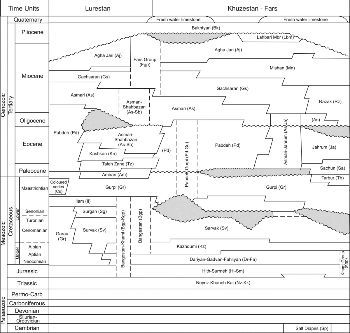
Stratigraphy in the Zagros (Fig. 2) records the evolution from the passive margin of the Arabian plate to the foreland basin of the Arabia–Eurasia collision zone, although the precise time of the onset of continental collision is debated. Common estimates are the Late Eocene (~35 Ma; e.g. Vincent et al. Reference Vincent, Allen, Ismail-Zadeh, Flecker, Foland and Simmons2005; Allen & Armstrong, Reference Allen and Armstrong2008; Ballato et al. Reference Ballato, Uba, Landgraf, Strecker, Masafumi, Stockli, Friedrich and Tabatabaei2011) and the Early Miocene (~20 Ma; e.g. Okay, Zattin & Cavazza, Reference Okay, Zattin and Cavazza2010), or even later (e.g. Guest et al. Reference Guest, Stockli, Grove, Axen, Lam and Hassanzadeh2006). Precambrian basement is not exposed in situ, but recorded as blocks brought to the surface in salt diapirs (Kent, Reference Kent1979), derived from the Hormuz Series. The Hormuz Series is of late Precambrian/Cambrian age, and overlies the basement. The Series is present across a wide area of the Zagros and Middle East (Edgell, Reference Edgell1991) and contains thick evaporites, mainly halite (Talbot & Alavi, Reference Talbot, Alavi, Blundell, Davison and Alsop1996). The original distribution of these evaporites is not known. Some geologists (e.g. Murris, Reference Murris1980; Edgell, Reference Edgell1991) infer that the present distribution of diapirs is a guide to the original depositional extent: these occur across large areas of the eastern Zagros (Fars), but not within the Dezful Embayment or further west (Fig. 1). Hormuz Series salt also crops out in the High Zagros to the north of the Embayment (National Iranian Oil Company (NIOC), 1977a). Areas without salt exposures were regions of clastic deposition or non-deposition in such schemes. Other studies extend the distribution of evaporites throughout the Zagros (Talbot & Alavi, Reference Talbot, Alavi, Blundell, Davison and Alsop1996), with later factors controlling its present distribution in diapirs (e.g. Kent, Reference Kent1979; Carruba et al. Reference Carruba, Perotti, Buonaguro, Calabro, Carpi, Naini, Mazzoli and Butler2006).
Stratigraphy of the Iranian Zagros. Modified from Iran Oil Operating Companies (1969) to reflect the diachronous nature of the Bakhtyari Formation (Fakhari et al. Reference Fakhari, Axen, Horton, Hassanzadeh and Amini2008).

The Hormuz Series lies at the base of a Palaeozoic platform succession. This is inferred to be interrupted by Permian rifting that led to the spreading of the Neo-Tethyan ocean from the contemporary margin of Gondwana (Şengör et al. Reference Şengör, Altiner, Cin, Ustaomer, Hsu, Audley-Charles and Hallam1988), although the evidence on which this is based remains sparse (Szabo & Kheradpir, Reference Szabo and Kheradpir1978). Sepehr & Cosgrove (Reference Sepehr and Cosgrove2004) illustrated examples of a Permian–Triassic half graben from the Dezful Embayment. An ~4–5 km thick Mesozoic and lower Tertiary succession contains alternating deposits of clastic rocks and carbonates (Setudehnia, Reference Setudehnia1978, Sherkati & Letouzey, Reference Sherkati and Letouzey2004; Farzipour-Saein et al. Reference Farzipour-Saein, Yassaghi, Sherkati and Koyi2009; Homke et al. Reference Homke, Verges, Serra-Kiel, Bernaola, Sharp, Garces, Montero-Verdu, Karpuz and Goodarzi2009). Mid Cretaceous (Bangestan Group) and Oligo-Miocene (Asmari) limestones form prominent topographic markers in the Zagros landscape, by virtue of their high mechanical strength and consequent low erosion rates. The equivalent stratigraphy in the sub-surface of the Dezful Embayment contains a sandstone unit, the Ahwaz Member (Motiei, Reference Motiei1993; Sharland et al. Reference Sharland, Archer, Casey, Davies, Hall, Heward, Horbury and Simmons2001). Gachsaran Formation evaporites (Miocene) form a second mobile unit in the stratigraphy (O'Brien, Reference O'Brien1957; Sherkati & Letouzey, Reference Sherkati and Letouzey2004), below a Miocene–Quaternary clastic succession that coarsens upwards (Homke et al. Reference Homke, Vergés, Garcés, Emami and Karpuz2004). These clastic deposits are divided into two main non-marine units, the Agha Jari and Bakhtyari formations, above a marine unit, the Mishan Formation (Fig. 2). The age of the Bakhtyari Formation was tentatively assigned to the Pliocene (James & Wynd, Reference James and Wynd1965), although age-diagnostic fossils are rare. Recent work (Fakhari et al. Reference Fakhari, Axen, Horton, Hassanzadeh and Amini2008) has demonstrated that outcrops in the northeast of the Zagros originally mapped as Bakhtyari Formation are as old as Early Miocene and possibly Oligocene. Thus this unit is strongly diachronous, and schemes invoking a regional, orogen-wide pulse of deformation in Pliocene time and a synchronous unconformity at the base of the Bakhtyari Formation (e.g. Falcon, Reference Falcon and Spencer1974; Carruba et al. Reference Carruba, Perotti, Buonaguro, Calabro, Carpi, Naini, Mazzoli and Butler2006) should be treated with caution.
3. Structure
This Section is in three parts. First, we describe the seismicity of the Dezful Embayment, as the earthquakes provide valuable information on the sub-surface structure that cannot be obtained by other means. Second, we describe the structure of the Embayment based on published accounts of the exposed and sub-surface geology, and our own field observations. Finally, we review the wider structure of the Zagros, with the particular aim of highlighting those features that vary along strike and may bear on the origin of the Embayment itself.
3.a. Seismicity
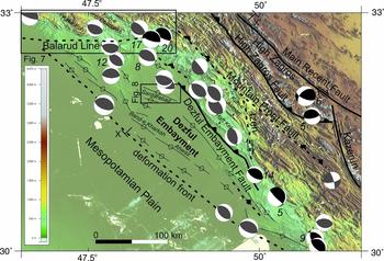
The instrumental earthquake record shows relatively intense seismicity within the Embayment compared with adjacent areas. This is allowing for a typical 20 km uncertainty in epicentre locations (Talebian & Jackson, Reference Talebian and Jackson2004). Figure 3 shows focal mechanisms from the Harvard seismicity catalogue (http://www.globalcmt.org/CMTsearch.html) and Talebian & Jackson (Reference Talebian and Jackson2004) and references therein. Events are typically steep-dipping thrusts (>30°), although it is not always possible to determine the real nodal plane. Focal depths range from a few kilometres to 20 km, especially deeper in the north. There is an uncertainty in these values of ±4 km. Down-dip rupture length for an M 5 event is typically 4 km and for M 6, 12 km; therefore, if an event of M 5–6 is at 20 ± 4 km it will rupture at 20 km, even if the true hypocentre is as shallow as 16 km (Maggi et al. Reference Maggi, Jackson, Priestley and Baker2000).
Dezful Embayment structural map, overlain on Shuttle Radar Topography Mission (SRTM) digital topography (using the CGIAR datasets, Jarvis et al. unpub. data, 2008: Hole-filled seamless SRTM data V4, International Centre for Tropical Agriculture (CIAT), http://srtm.csi.cgiar.org). Black focal mechanisms: body wave modelled focal mechanisms and fault plane solutions from Talebian & Jackson (Reference Talebian and Jackson2004) and references therein. Grey focal mechanisms: Harvard CMT events from 1977 to 2008 with >70% double-couple. Centroid depths (km) are shown in italics. Anticlines are highlighted west of the Dezful Embayment Fault.

Most events are located between the Dezful Embayment Fault and the Mountain Front Fault (Fig. 3) where topography is steepest. Higher regions (>1000 m elevation) to the northeast are less seismically active, although there are two oblique and strike-slip events recorded close to the Main Recent Fault and the Kazerun Line. One thrust earthquake took place close to the High Zagros Fault. Three events occurred close to the frontal anticlines of the Dezful Embayment, suggesting that these folds are underlain by thrusts similar to the structures further northeast.
Combining the earthquake depths with depth-to-basement maps confirms that in places the Zagros basement is actively thrusting (Jackson, Reference Jackson1980; Berberian, Reference Berberian1995; Maggi et al. Reference Maggi, Jackson, Priestley and Baker2000; Talebian & Jackson, Reference Talebian and Jackson2004; Tatar, Hatzfeld & Ghafory-Ashtiany, Reference Tatar, Hatzfeld and Ghafory-Ashtiany2004), but at the same time some seismogenic faulting occurs purely within the sedimentary cover (Koyi, Hessami & Teixell, Reference Koyi, Hessami and Teixell2000; Adams et al. Reference Adams, Brazier, Nyblade, Rodgers and Al-Amri2009). There is no difference in the orientation, magnitude or dip of events rupturing within the cover or basement, or both. There is some evidence for low angle (<20° dip) thrusting in the seismicity record, especially in the northeast of the Embayment, for example the 19 October 1980 event at 32.70°N48.58°E at 17 km depth (Maggi et al. Reference Maggi, Jackson, Priestley and Baker2000). Other low-angle slip is likely to happen aseismically, perhaps along weak detachment horizons (Casciello et al. Reference Casciello, Verges, Saura, Casini, Fernandez, Blanc, Homke and Hunt2009).
3.b. Dezful Embayment structure
The Dezful Embayment is a trapezoidal area within the Zagros Simply Folded Belt (Fig. 3), covering ~75000 km2. Isopachs for the Dezful Embayment show >5000 m of Cenozoic strata in the northeast of the region (Fig. 4a), predominantly Miocene–Quaternary non-marine clastic deposits, although the details vary between different sources (Koop & Stoneley, Reference Koop and Stoneley1982; Motiei, Reference Motiei1993; Bahroudi & Talbot, Reference Bahroudi and Talbot2003; Carruba et al. Reference Carruba, Perotti, Buonaguro, Calabro, Carpi, Naini, Mazzoli and Butler2006). Adjacent areas have far thinner successions over this interval, consistent with the Embayment being a depocentre within the Arabia–Eurasia collision zone. Precise ages are not known for large parts of this basin fill. Oligocene and Lower Miocene strata (Asmari Limestone and lateral equivalents) show differential subsidence patterns, with 600–900 m within the Embayment and only 200–400 m thickness outside of it (Fig. 4b). The Paleocene–Eocene succession is of similar thickness in the north of the Embayment and adjacent areas of the Pusht-e Kuh arc: ~100 m (not shown).
Isopachs of selected intervals for the Dezful Embayment and adjacent areas. Derived from Koop & Stoneley (Reference Koop and Stoneley1982) and Motiei (Reference Motiei1993).

Upper Cretaceous isopachs show a thin succession (<200 m) across the Dezful Embayment, in contrast to thicker accumulations to the northwest and southeast (1500 m and 500 m, respectively; Fig. 4c). Lower Cretaceous and Jurassic isopachs show no consistent difference between the Embayment and surrounding areas (Fig. 4d). Some Cretaceous activity along the Kazerun Fault is suggested by local isopach variations in this region (Sepehr & Cosgrove, Reference Sepehr and Cosgrove2005). To summarize these data, isopachs of Upper Cretaceous and Oligocene–Quaternary strata change across the Line (Fig. 4), indicating a pre-Cenozoic and pre-collision history to the structure (Motiei, Reference Motiei1993), as well as an Oligocene–Quaternary difference. Differences are not so apparent in the pre-Late Cretaceous and Paleocene–Eocene intervals.
The northeast boundary of the Dezful Embayment is the Mountain Front Fault (or Flexure), which is a step in the structural relief of several kilometres (Berberian, Reference Berberian1995), and possibly as much as 6 km at Kuh-e Kamar Meh (Figs 3, 5, 6a). The southwest boundary occurs along anticlines roughly in alignment with Zagros frontal structures to the northwest and southeast (Fig. 1). The eastern limit to the Embayment is the Kazerun Fault (Fig. 3), which is one of a series of right-lateral strike-slip faults that trend NNW–SSE through the Zagros at around longitudes 51–52°E (Kareh Bas, Sabz-Pushan and Sarvestan; Fig. 1; Authemayou et al. Reference Authemayou, Chardon, Bellier, Malekzadeh, Shabanian and Abbassi2006). Exposure levels on the eastern side of the fault are consistently deeper than to the west (typically Cretaceous versus Asmari Limestone). The offset of the fault is in the order of 10 km (Authemayou et al. Reference Authemayou, Chardon, Bellier, Malekzadeh, Shabanian and Abbassi2006). There is another, less clear-cut N–S structure west of the Kazerun Line, the Izeh Line (Fig. 3), but less is known about the structure of this feature. It also has structural relief across it. Exposure levels are typically down to the Asmari Limestone to its east and within the Gachsaran Formation or younger units to its west. This is an important factor in the regional hydrocarbon geology, as the Gachsaran Formation is an effective seal. It is part of the explanation why oil and gas fields are concentrated to the west of the Izeh Line. The northern limit of the Dezful Embayment is the Balarud Line (Fig. 7). Cretaceous strata are exposed in the anticlines to the north in the Pusht-e Kuh arc. We examine this feature in some detail, because its structure is less well understood than the other margins of the Embayment.
Structural cross-section for the Dezful Embayment. Constructed from data in Llewellyn (Reference Llewellyn1972, Reference Llewellyn1973) and NIOC (1975), with input from our fieldwork observations, seismicity (Fig. 3), published isopach maps and the half graben geometry shown by Sepehr & Cosgrove (Reference Sepehr and Cosgrove2004). The dashed line near the base of the sedimentary succession represents a speculative detachment at the level of the Hormuz Series salt or an equivalent. Location shown on Figure 3.

Field photographs of structures at the margins of the Dezful Embayment. (a) Kuh-e Kamar Meh and the position of the Mountain Front Fault (arrowed); (b) termination of the Kabir Kuh anticline, where Asmari Limestone strata (AL) plunge south towards the Balarud Line, with low relief Gachsaran Formation evaporites (GF) in the foreground; (c) view across the Balarud Line (arrowed) to the Kuh-e Chenareh anticline; (d) juxtaposition of the Gachsaran Formation (GF) and Quaternary sediments (Q) across the Dezful Embayment Fault at Haft Kel.

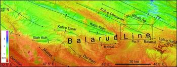
The E–W trend of the Balarud Line is an unusual orientation for a structure in the Zagros (Figs 1, 3; Bahroudi & Koyi, Reference Bahroudi and Koyi2004). The Balarud Line has been mapped as a left-lateral strike-slip fault (Berberian, Reference Berberian1995; Hessami, Koyi & Talbot, Reference Hessami, Koyi and Talbot2001), based on the apparent displacement of folds in its vicinity, such as Siah Kuh (Fig. 7). However, none of the major, well-constrained earthquakes in the vicinity are strike-slip events (Talebian & Jackson, Reference Talebian and Jackson2004; see Section 3.a. on seismicity). One event (2 April 1989, 32.66°N47.78°E) has a possible left-lateral focal plane, but the Harvard CMT solution is based on a 37% double-couple: much less than the 70% usually taken for a reliable solution. An inferred left-lateral slip of 120–130 km (Hessami, Koyi & Talbot, Reference Hessami, Koyi and Talbot2001; Bahroudi & Koyi, Reference Bahroudi and Koyi2003) is based on the apparent offset of the Mountain Front Fault, but this is arguably the distance between the southwestern exposures of the Asmari Limestone north and south of the Balarud Line. There is no evidence that an originally contiguous fault has been displaced.
Landsat TM imagery of the Balarud Line, at the northern side of the Dezful Embayment, draped over SRTM topography. This shows that no clear-cut fault can be seen at the surface in this area. Anticlines approach the Balarud Line from both the northwest and southeast, and are deflected towards more E–W orientations, but there is no bedrock, geomorphic or seismicity evidence for left-lateral faulting along the Line.

The structure in the region consists of anticlines that trend NW–SE, and plunge towards the Line (Fig. 7). Some individual fold traces are deflected towards an E–W orientation as they approach the Line. Two of the folds on the south side, within the Embayment, possess a roughly E–W orientation (Kabud and Balarud). None of the folds can be mapped across the Line, offset or not. Field relations show the plunge of the folds as they approach the Line from one side or the other. Figure 6b shows the abrupt SE termination of the Kabir Kuh anticline, which runs for >200 km to the northwest, but plunges and dies out over a lateral distance of 3 km, adjacent to the Balarud Line. Figure 6c shows an equivalent view of the Kuh-e Chenareh anticline, which is the next fold to the east of Kabir Kuh (Fig. 7).
To summarize, there is no strong geological or geomorphic evidence for the existence of an active, emergent fault along the Balarud Line, of whatever motion sense. Nor do the seismicity data indicate an active fault with an E–W trend (Fig. 3). However, the Balarud Line exerts a strong control on the tips of folds to either side of it, which needs to be explained. Isopach data show the different sedimentary thicknesses on either side of the Balarud Line (Fig. 4), which implies a step in the surface of the basement; the Line must separate more deeply buried basement within the Embayment from equivalent rocks to the north. Sedimentary horizons must likewise be present at different depths, although the very variable Cenozoic stratigraphy means that a particular unit found within the Embayment may not be present to its north in the same form, if at all. We suggest that this contrast and discontinuity in the basement and cover succession has prevented folds and thrusts from propagating laterally across it, leading to the situation where folds terminate along the Balarud Line, without necessarily being offset by slip along it. A steeply dipping, E–W-trending fault does not have a favourable orientation to slip during the N–S plate convergence of the Arabia–Eurasia collision, but the presence of such a discontinuity may well affect the active folds and thrusts to its north and south. This is an explanation for why the Balarud Line behaves as it does at present. It does not answer the question of why different successions accumulated on either side of it from Late Cretaceous time onwards, which we address in Section 3.c.
NW–SE-trending anticlines dominate the internal structure of the Embayment (Fig. 3). Exposure levels deepen from southwest to northeast, such that the frontal structures expose Upper Miocene–Quaternary clastic deposits mapped as Agha Jari and Bakhtyari formations. West of the Izeh Line, evaporites of the Gachsaran Formation crop out northeast of the Dezful Embayment Fault (Fig. 6d; Berberian, Reference Berberian1995); this step in the exposure level indicates a significant thrust within the Embayment. Only Kuh-e Asmari (Fig. 3) exposes the Asmari Limestone west of the Izeh Line and southwest of the Mountain Front Fault. East of the Izeh Line there is a more rapid deepening of exposure level northwards from the coastal anticlines (Sherkati & Letouzey, Reference Sherkati and Letouzey2004).
The typical sub-structure of the anticlines is largely known from limited well and seismic data (Sepehr & Cosgrove, Reference Sepehr and Cosgrove2004; Carruba et al. Reference Carruba, Perotti, Buonaguro, Calabro, Carpi, Naini, Mazzoli and Butler2006): the moderate exhumation precludes direct observation of dissected folds. Structures are complicated by the Gachsaran Formation evaporites decoupling the structure above and below their level (Sherkati & Letouzey, Reference Sherkati and Letouzey2004; Sherkati et al. Reference Sherkati, Molinaro, de Lamotte and Letouzey2005; Carruba et al. Reference Carruba, Perotti, Buonaguro, Calabro, Carpi, Naini, Mazzoli and Butler2006). Where the unit is still buried it acts as a detachment zone, such that overlying sediments may be folded into relatively simple, coherent anticlines, but the fold axes are displaced by a few kilometres to the southwest with respect to fold crests within the underlying strata. Where the Gachsaran Formation is exposed it has flowed, leading to more complex structures within and below the unit and disharmonic relationships between the folds above and below the evaporites (Sherkati et al. Reference Sherkati, Molinaro, de Lamotte and Letouzey2005; Fig. 5).
It is a long-standing issue of Zagros geology to what degree, if any, thrusts cut the basement. Some work suggests major basement involvement (Jackson, Reference Jackson1980; Ameen, Reference Ameen1992), but other papers show essentially complete detachment within the sedimentary cover (McQuarrie, Reference McQuarrie2004). There are also papers that suggest a mixture of the two structural styles (Blanc et al. Reference Blanc, Allen, Inger and Hassani2003; Mouthereau et al. Reference Mouthereau, Tensi, Bellahsen, Lacombe, De Boisgrollier and Kargar2007) or a development from initial thin-skinned to later thick-skinned geometries (Molinaro, Zeyen & Laurencin, Reference Molinaro, Zeyen and Laurencin2005). See Ahmadhadi, Lacombe & Daniel (Reference Ahmadhadi, Lacombe, Daniel, Lacombe, Lavé, Vergès and Roure2007) for a detailed field-based study of evidence for basement involvement in the early stages of Zagros deformation. As described in Section 3.a., the Zagros seismicity record clearly shows at least some basement thrusting (Tatar, Hatzfeld & Ghafory-Ashtiany, Reference Tatar, Hatzfeld and Ghafory-Ashtiany2004; Talebian & Jackson, Reference Talebian and Jackson2004), and that there is no difference in dip or strike between the deepest and shallowest events of M > 5. We use this seismicity constraint with the exposed geology and sub-surface constraints to generalize the fold and fault structure within the Dezful Embayment (Fig. 5). We envisage that the typical thrusts within the Embayment are planar and relatively steep, and typically link through the sedimentary cover to the basement. They are plausibly inversions of the Permian rift faults of the Arabian margin (Sepehr & Cosgrove, Reference Sepehr and Cosgrove2004), and this is indicated schematically on Figure 5. This is speculative, but consistent with the earthquake data and the sub-surface data of Sepehr & Cosgrove (Reference Sepehr and Cosgrove2004). The inferred fault spacing is 10–20 km (Fig. 5), which is also consistent with inverted continental rifts (Jackson, Reference Jackson1980). Such planar fault geometries for the main thrusts do not rule out detachments operating within the sedimentary cover. Detachments are conclusive within the Gachsaran Formation within the Embayment, and highly likely at deeper levels (Carruba et al. Reference Carruba, Perotti, Buonaguro, Calabro, Carpi, Naini, Mazzoli and Butler2006). However, the Hormuz Series evaporites have not been proven in the sub-surface of the Dezful Embayment, and so we do not depict major detachment at the base of the sedimentary succession (Fig. 5). It is geometrically possible that folds do detach at this level, either on the Hormuz Series salt (Carruba et al. Reference Carruba, Perotti, Buonaguro, Calabro, Carpi, Naini, Mazzoli and Butler2006) or a lateral shale equivalent (McQuarrie, Reference McQuarrie2004), but Figure 5 offers an alternative model.
The Hormuz Series definitely plays a role northeast of the High Zagros Fault, where it crops out associated with thrust slices that exhume the Palaeozoic stratigraphy but not the basement. This region is therefore more likely to have a major detachment along the Hormuz Series rocks, with the underlying basement underthrust beneath the Sanandaj–Sirjan Zone of Central Iran. The structure close to the suture zone is cross-cut by the active, right-lateral Main Recent Fault, which has two strands in this area (Authemayou et al. Reference Authemayou, Chardon, Bellier, Malekzadeh, Shabanian and Abbassi2006).
Total crustal thickness under the Zagros has recently been constrained by teleseismic receiver function analysis to be 42 ± 2 km, only thickening to ~55–70 km close to the Main Zagros Reverse Fault (Paul et al. Reference Paul, Hatzfeld, Kaviani, Tatar, Péquegnat, Leturmy and Robin2010). This result has the implication that the Zagros crust is not significantly thicker than the foreland of the Arabian plate, which also has a crustal thickness of ~40 km (Gok et al. Reference Gok, Mahdi, Al-Shukri and Rodgers2008).
3.c. Regional structure
The previous Section made the observation that something has made the Dezful Embayment have a different subsidence record from adjacent areas in Late Cretaceous and Oligocene–Recent times. This Section addresses the regional structure, and proposes an explanation for the structural and stratigraphic variation.
North of the Dezful Embayment, the Simply Folded Belt and High Zagros are collectively known as the Pusht-e Kuh arc (Fig. 1). This is commonly shown as a salient between the Dezful Embayment and the Kirkuk Embayment further north (Bahroudi & Koyi, Reference Bahroudi and Koyi2003), although as noted the frontal structures of the Pusht-e Kuh arc are roughly aligned with the frontal structures to the northwest and southeast (Fig. 1). Structural style across the Simply Folded Belt in the Pusht-e Kuh arc is more uniform than an equivalent transect across the Dezful Embayment and the zone to its northeast, the Bakhtyari Culmination (e.g. Farzipour-Saein et al. Reference Farzipour-Saein, Yassaghi, Sherkati and Koyi2009; Fig. 5). Structures close to the range front exhume the Cretaceous carbonates, and this level of exposure is maintained across the remainder of the Simply Folded Belt to the northeast, or becomes shallower, exposing the Oligocene–Miocene limestones. There is a sharp contrast in geology at the High Zagros Fault, which thrusts Cretaceous deepwater marine sediments, known as the Radiolarite Series, to the southwest (Homke et al. Reference Homke, Verges, Serra-Kiel, Bernaola, Sharp, Garces, Montero-Verdu, Karpuz and Goodarzi2009). Higher nappes include at least two ophiolite slices (collectively known as the Kermanshah ophiolite; Ghazi & Hassanipak, Reference Ghazi and Hassanipak1999), and an allochthonous slice of Upper Triassic–Cretaceous limestones: the Bisotun Limestone (NIOC, 1978; Agard et al. Reference Agard, Omrani, Jolivet and Mouthereau2005). An alternative explanation for the structure in this region is that the ophiolites belong to a single sheet, folded beneath an overlying thrust sheet (Mohajjel, Fergusson & Sahandi, Reference Mohajjel, Fergusson and Sahandi2003). There are no Lower Palaeozoic strata and no Hormuz Series evaporites exposed in this region. The highest, sub-horizontal nappes are derived from the Sanandaj–Sirjan Zone, i.e. they originated on the Eurasian side of the suture (Agard et al. Reference Agard, Omrani, Jolivet and Mouthereau2005). The suture is the thrust plane below this pile of Eurasian-derived nappes. Overall, the High Zagros is ~40 km across in this region. The structure is complicated by the Main Recent Fault, which cuts through the low-angle thrusts and nappes in this area (Talebian & Jackson, Reference Talebian and Jackson2002).
To the northeast of the Dezful Embayment, the remainder of the Simply Folded Belt is ~40 km wide, and is overthrust by imbricated strata of the Arabian plate at the High Zagros Fault (Fig. 5). Collectively, this mountainous, highly deformed area is known as the Bakhtyari Culmination (Figs 1, 5). Thrust sheets northeast of the High Zagros Fault expose the stratigraphy down to the Cambrian, and the Hormuz Series salt is exposed along fault traces (Authemayou et al. Reference Authemayou, Chardon, Bellier, Malekzadeh, Shabanian and Abbassi2006). The High Zagros is only 25–40 km wide in this region, before the Main Zagros Reverse Fault is reached. There are no ophiolites or Radiolarite Series rocks along or southwest of this part of the suture; Eurasian plate rocks on the northeast side are mapped as metamorphic rocks, and are overlain unconformably by Cretaceous carbonates (NIOC, 1975).
The structure of the Zagros, especially the High Zagros, is different again across the Fars region to the east and southeast of the Dezful Embayment (Mouthereau et al. Reference Mouthereau, Tensi, Bellahsen, Lacombe, De Boisgrollier and Kargar2007; Fig. 1). Anticlines in the Simply Folded Belt typically exhume strata as deep as the Cretaceous Bangestan Group. Permian strata are exposed at Kuh-e Surmeh (Fig. 1), but this is an unusual structure, as it is at the end of a strike-slip fault (Mouthereau, Lacombe & Meyer, Reference Mouthereau, Lacombe and Meyer2006). There is no consistent northwards increase in the amount of exhumation across the Simply Folded Belt (NIOC, 1977a). Some of the most extensive exposures of Cretaceous strata occur in the southern folds, which are also the highest topographic ranges. The High Zagros Fault is mapped at the southern edge of the regional exposure of Cretaceous strata (Berberian, Reference Berberian1995), but this is less of a clear-cut boundary than is depicted on summary tectonics maps. It is not the absolute southern exposure of Cretaceous strata, nor is it the northern limit of Tertiary strata within anticline cores. Within the High Zagros of Fars there is no discernible difference in structural style from the Simply Folded Belt to its south: whaleback anticlines exhume down to the Bangestan Group. The northeast side of the High Zagros is more variable. In some places the Cretaceous-cored anticlines occur up to the line of the Main Zagros Reverse Fault, which juxtaposes them against metamorphic basement of the Sanandaj–Sirjan Zone to the northeast. But, there is also the Neyriz ophiolite complex and associated Radiolarite Series rocks (Babaie et al. Reference Babaie, Babaei, Ghazi and Arvin2006), which are emplaced to the southwest, over the Cretaceous passive margin strata (Fig. 1). Southeast of the main ophiolite outcrop, there is a salient of the Sanandaj–Sirjan Zone of Central Iran (Fig. 1), where low-grade metamorphic rocks are thrust southwest over the Arabian plate stratigraphy (NIOC, 1977a).
The above account of the regional geology of the Zagros demonstrates that lateral differences across the Iranian sector of the Simply Folded Belt (Pusht-e Kuh/Dezful Embayment/Fars) have counterparts in variations in the structure and stratigraphy of the High Zagros and suture zone. Given this variation, it is possible to look for clues to the origin of the Dezful Embayment. Key points are (1) the Late Cretaceous was the first time that different sedimentary thicknesses clearly distinguish the Embayment from surrounding areas; (2) the Late Cretaceous saw a thinner sedimentary succession over the Embayment than surrounding areas, but the Cenozoic, especially upper Cenozoic, strata are thicker; (3) significant ophiolite nappes are present north and south of the Embayment, but not within the Bakhtyari Culmination, across strike from the Embayment itself.
Upper Cretaceous isopach variation may be explained as follows. Ophiolite and associated nappe emplacement over the Pusht-e Kuh arc and Fars region generated greater contemporary subsidence in front of those nappes, compared with the intervening Dezful Embayment, hence the Upper Cretaceous isopach variations (Fig. 4c). This model raises the question of why ophiolite emplacement varied spatially, which is hard to answer, but is common along other continental collision zones (Cawood & Suhr, Reference Cawood and Suhr1992). A possible scenario is an Arabian plate promontory at the future Bakhtyari Culmination, leading to the generation and rapid emplacement of ophiolitic lithosphere at the adjacent embayments along the leading edge of the Arabian plate. This is similar to the model proposed for Caledonian ophiolite generation in the Caledonides (Cawood & Suhr, Reference Cawood and Suhr1992). During subsequent continental collision, such a promontory would focus deformation within the Arabian plate, leading to the present imbrication of the Bakhtyari Culmination and the rapid subsidence of the Dezful Embayment in front of it.
4. Geomorphology
Anticlines within the Dezful Embayment coincide with modest topographic highs, generally only a few tens of metres above the surrounding plains, which are themselves only a few metres above sea level (Fig. 8). Upper Cenozoic clastic rocks assigned to the Agha Jari and Bakhtyari formations (Fig. 2) are exposed at the fold crests. The fossil-poor, terrestrial nature of these units means that assignments are done mainly on the basis of the lithologies, with little biostratigraphic control (James & Wynd, Reference James and Wynd1965). This practice means that some of the finer-grained strata assigned to the Agha Jari Formation are potentially time equivalent to coarser strata mapped as Bakhtyari Formation. The Ahwaz structure (Fig. 3) is an example of this: the uppermost exposed strata along the fold crest are mapped as Agha Jari Formation (NIOC, 1975), which, if a strict layercake stratigraphy applies, suggests that the fold has uplifted, exhumed and eroded the entire Bakhtyari Formation since some time in the Pliocene, or at least its non-deposition. This seems unlikely, given that the structure has only a few tens of metres of elevation above the surrounding alluvial plains. Modern drainage patterns and deposition make a similar point: drainage across the Dezful Embayment is centripetal, rising on all three mountainous margins and focusing on the Tigris in the southwest. Rivers at the margins of the Embayment are commonly braided and carry a cobble-grade bedload. Their downstream equivalents in the Embayment interior are typically meandering (such as the Dez and Karun, Fig. 8) and carry more fine-grained sediment. These two present settings probably typify much of the upper Cenozoic clastic sedimentation across the Zagros, with the finer-grained ‘Agha Jari’ type passing upwards into coarser ‘Bakhtyari’ sediments as deformation advanced towards a given area, thereby increasing relief and sediment grade. A further implication is that interpretations of pulses of deformation, based on unconformities beneath conglomeratic facies (e.g. Falcon, Reference Falcon and Spencer1974), need to be treated with caution. Such a sedimentary switch might represent the local progradation of higher energy transverse deposits over lower energy axial or centripetal systems, not a Zagros-wide pulse of deformation.
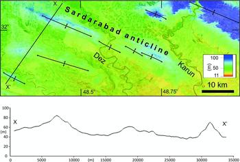
Landsat TM image of the Sardarabad anticline in the Dezful Embayment, at 50% transparency and draped over SRTM digital topography (scale saturated at 100 m elevation), illustrating the low relief of active structures within the Embayment area. Whilst the Dez River has enough stream power to cut through the rising fold, the Karun River is deflected to the east around the fold tip. Double-headed arrows mark the individual anticline axes mapped by Llewellyn (Reference Llewellyn1972). The topographic profile X–X′ has ~75× vertical exaggeration, and illustrates the low relief of anticlines within the Dezful Embayment.

Individual folds interact with drainage systems, typified by the Sardarabad anticline (Fig. 8). This is a composite structure with four separate culminations along its length (Llewellyn, Reference Llewellyn1972). The topographic relief above surrounding plains is ~40 m. The Dez River is antecedent and cuts through the middle of the anticline. Notably this is not at one of the relay zones between the culminations, but in the middle of a culmination, at least at the present exposure level, which is mapped as the Agha Jari Formation. The river changes planform from meandering to a relatively straight reach as it crosses the fold, reverting to a meandering planform downstream, which is a typical response of low gradient rivers as they cross a zone of active surface uplift (Holbrook & Schumm, Reference Holbrook and Schumm1999). In contrast, the Karun River is diverted around the southeast tip of the fold, presumably tracking the lateral growth of the fold tip in the same direction.
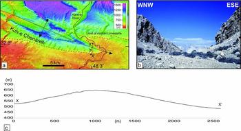
Lateral fold growth is preserved in higher relief anticlines at the margins of the Dezful Embayment, where wind gaps/dry valleys are preserved along fold crests, e.g. near the eastern tip of the Kuh-e Chenareh anticline (Figs 3, 9). Such wind gaps are common in the Zagros (Burberry, Cosgrove & Liu, Reference Burberry, Cosgrove and Liu2008; Ramsey, Walker & Jackson, Reference Ramsey, Walker and Jackson2008), and are useful indicators of the previous patterns of drainage. The example in Figure 9 has relief of 125 m along the longitudinal wind gap profile, i.e. along the inferred original path of the river channel from the upstream end (north) to the axis of the anticline. The present drainage is diverted around the fold, lying some 3 km further east, but this channel also lies within the topographic expression of the fold and so may in turn become abandoned at some stage in the future. The rates of surface uplift and lateral fold propagation are unknown.
Wind gap development at Kuh-e Chenareh. (a) Landsat image draped over SRTM topography of the Kuh-e Chenareh anticline, showing the topographic plunge towards the ESE. (b) View northwards from the crest of the wind gap (‘eye’ symbol in (a)), showing the gorge created by the original drainage through the Asmari Limestone bedrock. (c) Topographic profile along X–X′ in (a), showing the present relief along the original north-to-south river channel.

5. Discussion and conclusions
The greater part of the Zagros lies within the Simply Folded Belt, but this region is not homogeneous along strike, being an alternating sequence of low relief, low elevation ‘embayments’ and high relief, high elevation ‘salients’ or ‘arcs’ (Fig. 1). These quotation marks are advisable: the deformation front is distinctly linear along the Zagros west of the Kazerun Line, while the Fars region has an arcuate deformation front that does not step abruptly southwards of the eastern limit of the Dezful Embayment.
Published isopach data (Fig. 4) show major differences in thicknesses or facies between the Dezful Embayment and adjacent areas before Late Cretaceous time (Koop & Stoneley, Reference Koop and Stoneley1982; Motiei, Reference Motiei1993). Upper Cretaceous isopachs are thinner within the Embayment than outside it, from which we infer that the Embayment first became a distinct area at this time, but as a structural high (there is no evidence for local post-Late Cretaceous deformation, uplift and erosion removing strata across the Embayment). This timing pre-dates continental collision, but is consistent with the age of ophiolite emplacement over the Arabian margin. The present distribution of ophiolites has a notable correlation with the structure and stratigraphy of the remainder of the Zagros to the southwest (Fig. 1). Upper Cretaceous isopachs are thicker in front of the Kermanshah and Neyriz ophiolites than the intervening region (Dezful Embayment). We suggest that this stratigraphic variation results from different nappe loading along the Arabian margin, i.e. the present distribution of the ophiolites and Radiolarite Series reflects their original extent and is not simply an artefact of differential erosion in the Cenozoic. It is less clear why ophiolite obduction should have been irregular, and whether this was a consequence of the structure of the Arabian margin (e.g. a promontory northeast of the present Dezful Embayment), or lateral variation within the Tethyan oceanic crust and its subduction zone.
Palaeogene isopachs and facies are little different between the Embayment and its surroundings, consistent with this being a relatively quiescent time between the ophiolite emplacement and the initial continental collision in Late Eocene time (Allen & Armstrong, Reference Allen and Armstrong2008). The Ahwaz Sandstone Member suggests clastic sediment was preferentially transported into the Embayment as far back as Oligocene time. The Dezful Embayment is a Late Cenozoic depocentre, consistent with rapid subsidence in this interval and in contrast to the elevation of neighbouring regions.
Variations along strike in the High Zagros occur at the same places as within the Simply Folded Belt, and the intense imbrication of the Bakhtyari Culmination is not matched by similar thrusting of the Arabian plate margin in regions to the northwest or southeast. This variation is consistent with an original promontory at this point on the Arabian plate margin, now smoothed out by the collision. We further suggest that this imbrication and thrust sheet loading resulted in greater subsidence of the Dezful Embayment than other areas of the Simply Folded Belt.
Acknowledgements
We thank the Geological Survey of Iran for their help, without which this work would have been impossible. Eric Blanc and James Jackson are thanked for numerous discussions on Zagros geology. MBA acknowledges the sponsors of CASP's Iran project. Two anonymous referees provided very helpful and constructive reviews, while the editorial efforts of Olivier Lacombe and Guy Simpson are much appreciated.