

CARMARTHENSHIRE
(1) Carmarthen (Moridunum): (a) 131 Priory Street (SN 4160 2036):Footnote 1 an archaeological evaluation revealed deposits containing fragments of Roman pottery, ceramic building material, mortar and plaster immediately to the rear of the street front property at a depth of 0.55 m below existing ground level (22.13 m OD) at its highest. These deposits appear to consist of general demolition material from domestic occupation. Some small pits or post-holes were identified but no positive structural remains could be determined within the confines of the evaluation works. The demolition deposits spread roughly halfway up the rear plot before giving way to apparently later garden soils, still containing fragments of Roman pottery. Towards the street frontage these deposits had been disturbed by post-medieval development, whilst to the rear of the plot the deposits were overlaid by up to 0.8 m of later garden soils.Footnote 2
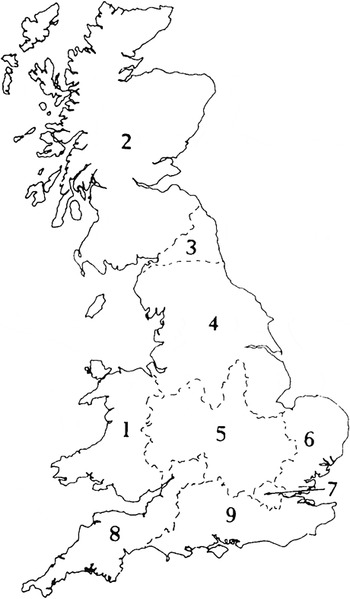
Key to numbered sections of Part I (Sites Explored).
(b) Richmond Park Football Ground (SN 41585 20372):Footnote 3 an evaluation trench revealed Roman deposits at approximately 1.3 m below current ground level. The Roman deposits included a mix of demolition deposits and possible roughly-made surfaces. They had been truncated by a number of modern pits and services. The Roman deposits were sealed by a significant depth of garden soils, possibly accumulated across the area since the medieval period. A watching-brief during the groundworks recorded, at the very base of the excavated area on the western side of the building footprint, the surface of a Roman road where there was a raised agger. Evidence for wheel ruts was noted running along its roughly north to south alignment, with a possible short length of east to west rutting also noted. Presumably this road would have formed part of the formal road layout, and should thus enhance understanding of the insula layout of the town.Footnote 4
(2) Ffairfach, Lovelodge Farm (SN 6230 2150): the line of a Roman road leading south-south-west from Llandeilo passes through the southern part of the area, visible as a large linear earthwork. A single trench was excavated across the line of the road which demonstrated that almost all of any original metalled surface had been removed through ploughing over the years. Roadside ditches were visible on the geophysical survey and were identified within the evaluation trench, although one had been buried beneath a build-up of colluvial material. Two square enclosures were revealed on the geophysical survey, which are tentatively interpreted as Roman practice camps close to the Roman fort at Llandeilo, although further excavation would be needed to confirm their date and character.Footnote 5
DENBIGHSHIRE
(1) Bodelwyddan, land east of Bodelwyddan (SJ 0113 7558): following an extensive geophysical survey, trial trenching confirmed the existence of a double-ditched enclosure with the overall dimensions of c. 92 m north-east/south-west by up to 41 m north-west/south-east with the north-easternmost enclosure element measuring c. 50 m by c. 41 m and the south-westernmost enclosure element measuring c. 42 m north-east/south-west by up to 40 m north-west/south-east. The enclosure had a metalled entrance surface to the north and internal structural remains that include a probable roundhouse. Contemporary settlement features were also found; these are associated with the dispersal of groundwater and disposal of domestic waste. The finds were limited to Roman pottery that included Central Gaulish samian and local Holt produced coarse wares, a second- to third-century wheel-cut glass vessel fragment, tegulae, worked stone that included a Millstone grit rotary quern, and domestic animal bone. The palaeo-environmental samples recovered suggested scattered occupation waste that included limited charred cereal grains and herb/weed seeds mixed with small quantities of charcoal.Footnote 6
(2) Corwen, Druid (SJ 038 434): an evaluation of a small square-barrow cemetery exposed a partial section of the Roman road from Chester and Caer Gai (RR66a).Footnote 7
MERTHYR TYDFIL
(1) Penydarren, football pitch (SO 0499 0673): trial excavations and a watching-brief revealed that the grandstands had destroyed parts of the Roman fort but there is still stratified Roman archaeology within the centre of the pitch.Footnote 8
MONMOUTHSHIRE
(1) Caerwent (Venta Silurum) (ST 468 905): a small area of cobbles, probably the fragmentary remains of the Roman street, was exposed in a cable trench in the road (ST 46967 90548). Groundworks on the east and the west of the entrance to the Visitor Centre (ST 46741 90582) revealed two sections of walling and an area of rubble on the east, containing Roman pottery.Footnote 9
(2) Mathern, Killcrow Hill (ST 4984 9019): aerial reconnaissance discovered cropmarks of a Roman marching camp situated on a low ridge, c. 2.7 km east of Caerwent ( fig. 2).Footnote 10 The camp measures 113 m south-west/north-east by 87 m north-west/south-east and encloses 0.98 ha, making it the smallest camp in Wales and the Marches. It has well-defined simple gateways on the north side (7 m wide) and west side (6 m wide) but entrance gaps, if they exist, on the south and east sides are obscured by a lack of clarity in the cropmark and by darker patches of deeper soil on the east side. It probably dates to the earliest Roman campaigns in the region, of which some of the earliest in south-east Wales against the Silures date to a.d. 49–50.Footnote 11
Killcrow Hill Roman marching camp, Mathern; air photo mapping. (Crown Copyright RCAHMW. © Crown copyright and database rights [2014] Ordnance Survey [100022206])

(3) Monmouth: (a) Rockfield Road (SO 502 126): a watching-brief recorded Roman pottery, including Severn Valley ware, South Wales grey ware, Oxford colour-coated ware, Mancetter/Harthill mortarium and a decorated body and base sherd of samian. It is, however, believed that a quantity of soil, which came from the upper part of the town of Monmouth, had been deposited in the field where the work was taking place.Footnote 12 (b) Sergeant's Wood (SO 48250 13343): fieldwalking found an area of bloomery iron slag, thought to be of Roman date, in the plough soil.Footnote 13
(4) Wonastow, Court Farm (SO 4842 1109): aerial photographs recorded cropmarks showing the eastern portion of the fort which had eluded previous investigators.Footnote 14 The new photographs show the continuation of the southern defences of the fort to the east, with the previously unrecorded south-east angle of the fort seen at SO 485 111. This gives an approximate east–west measurement for the fort of 180 m, to the centre line of the defences. The defences then swing north and can be traced for some 130 m before they reach a patch of woodland. There appears to be an original break in these eastern defences towards their southern angle, possibly the site of a gate. There is also the suggestion of a partition or annexe midway along the fort with a ditch returning west, but a lack of clarity in the cropmarks here does not permit some details to be resolved without further ground-based remote sensing.Footnote 15
NEWPORT
(1) Caerleon (Isca): (a) Great Bulmore Farm (ST 35906 91521): groundworks revealed undisturbed Roman archaeological levels and walling. Hand excavations carried out on the footprint of the extension exposed an occupation layer dated from the second to third century a.d. with a later Roman industrial structure. The west wall of a large building partly recorded in 1983–4 was uncovered,Footnote 16 while a second north–south building is interpreted as part of a post-Roman structure.Footnote 17
(b) St Cadoc's House (ST 33942 90812): a layer of compacted yellow-brown sandy clay with fragments of Roman brick and roof tiles was uncovered in the first 6 m of the trench. It was tentatively interpreted as the top of the archaeological resource. The remaining length of the trench was cut entirely in the topsoil.Footnote 18
PEMBROKESHIRE
(1) Wiston (SN 0254 1844):Footnote 19 three trenches were opened up to confirm geophysical survey results that the site is the first Roman fort to be identified within Pembrokeshire. The trench targeting the northern defences confirmed the presence of three ditches surrounding a clay and turf rampart. A trench within the south-western corner of the fort confirmed the presence of timber buildings in the form of stone-lined post-holes lying on the inside of the substantial intervallum road. Between the intervallum road and rampart was a burnt area with possible remains of air-dried clay bricks built against the rampart edge. The geophysical survey results had shown a trapezoidal enclosure within the centre of the fort which was also confirmed to be of Roman date, although of unknown function. Pottery analysis indicates that the fort phase dates between the later first and early second century a.d., predominantly comprising imported wares from the Continent. Pottery from the trapezoidal enclosure area indicates a mid-second- to mid-third-century date, comprising local and British manufactured wares. Further investigative works are proposed in and around the fort site.Footnote 20
POWYS
(1) Beulah, Caerau (SN 9239 5016): test pitting continued in the vicus to define its extent to the north and north-east of the fort.Footnote 21 A linear earthwork, also on the north side of the fort, proved to be a bank and ditch of Roman date; its function appeared to be defensive, perhaps representing part of an annexe on the north-east side of the fort. Further geophysical survey identified a building with a number of rooms around a central courtyard to the north-east of the fort, and nearby was a large anomaly that could indicate a military bath-house.Footnote 22
(2) Brecon, Cefn-Brynich (SO 0731 2735): aerial photographs show the southern third of a large new Roman fort with earth and timber defences whose degraded platform is also poorly represented on LiDAR images, though the rampart is barely perceptible on the ground ( fig. 3).Footnote 23 On the basis of the LiDAR image the fort appears to measure about 260 m north–south by 215 m east–west, encompassing some 5.5 ha overall, excluding the counterscarp. The site occupies ground sloping to the south and is traversed by the A40(T) whose re-engineered course has led to a fall of some 3 m from the road to the field in which the cropmarks appeared. The cropmarks show ditches defining the south-west and south-east corners of the fort with some clarity, the eastern defences comprising a triple ditch system which may have been continued as far as the south-east corner, from which a pair of ditches spring, running south towards the river and clearly defining the eastern side of an annexe. The southern defences of the fort are unfortunately ill-defined, except close to the south-west corner, where the ditches appear as a pair, thereafter continuing north to define the western side of the site. Faint traces of two ditches also run south from the south-western corner, representing the western side of the annexe. The site of the south gate of the fort is unfortunately obscured, whilst the only discernible feature in the interior is the intervallum road, which appears as a parch-mark. Set some 6 m and 25 m from the western defences of the fort two other ditches are visible, the outer being much wider (c. 8 m) than the inner, both sharing the same axis as the western defences of the fort. Extending 120 m west of the outer ditch are the cropmarks of a neatly rounded north-west corner of a single ditched rectangular enclosure. This may possibly represent part of another annexe, or alternatively a marching or construction camp.Footnote 24
Plan of the Cefn-Brynich Roman fort, showing cropmark features mapped for the southern half of the site and the positions of low, spread earthworks of inner ramparts and the eastern counterscarp mapped from 2 m LIDAR data. (Crown Copyright RCAHMW. © Crown copyright and database rights [2014] Ordnance Survey [100022206])

(3) Old Radnor: (a) Hindwell (SO 2505 6065): a trapezoidal enclosure, 35 m across and close to the large Neolithic palisaded enclosure, was examined in two trenches that revealed a shallow surrounding ditch, no more than 1.5 m in width and 0.7 m deep. Late Iron Age/Romano-British pottery was recovered from the lower fill of the ditch.Footnote 25
(b) Hindwell Farm Barrow II (SO 2522 6092): within the putative Bronze Age barrow, a group of 12 or 13 areas of burning was identified by geophysical survey; one was evaluated. There was no specific dating evidence, but they are thought to be Roman field ovens, presumably associated with a large marching camp lying a few metres away to the south-west.Footnote 26
VALE OF GLAMORGAN
(1) Cowbridge, 69 Eastgate (SS 97750 74545): preparatory works for an extension revealed an isolated Roman well or pit immediately to the north-west of the house. No further evidence of Roman or medieval activity was found during ground reduction work in the garden, nor during the excavation of the foundations for garages. The Roman sub-circular feature could be interpreted as a well either associated with a domestic settlement or with a workshop or industry. The presence of Roman features to the east of the High Street is unusual but confirms that Roman occupation extended eastward beyond the core of the known area centred along the northern side of the High Street.Footnote 27
NORTH OF THE ANTONINE WALL
ORKNEY
(1) Lingro (HY 43 09): two denarii (of Trajan and Hadrian) discovered near the Iron Age broch are likely to be strays from a small scattered hoardFootnote 28 found at the site in antiquarian work.Footnote 29
ANGUS
(1) Dun (NO 689 596): aerial photographyFootnote 30 identified a rectangular feature within the temporary camp, aligned on the defences ( fig. 4).Footnote 31
Aerial photograph of the camp at Dun, with internal feature highlighted. (By courtesy of Dr D.J. Woolliscroft)

PERTH AND KINROSS
(1) Cargill (NO 163 376): magnetic survey over the fortlet ( fig. 5)Footnote 32 confirmed details of the roundhouses and associated souterrains around and beyond its south-west corner; by contrast, there is no trace of internal features associated with the fortlet.Footnote 33
Magnetometry survey of Cargill fortlet. (By courtesy of Dr D.J. Woolliscroft)

(2) Longforgan (NO 30067 30270): evaluation trenchesFootnote 34 revealed an unusual broad U-shaped profile (2.75 m wide, 0.76 m deep) to the ditch on the south-east side of this camp.Footnote 35 A U-sectioned ditch was cut much later into its infilled top, apparently on the same line ( fig. 6). The small area of interior which was examined proved sterile.
Section of the south-east ditch of the Longforgan temporary camp (interior lies to the right). (By kind permission of CFA Archaeology Ltd)

(3) Kay Craig (NN 9744 1287): excavationFootnote 36 of an Iron Age enclosure site produced two sherds of Roman glass.Footnote 37
STIRLING
(1) Stirling, Beechwood Park (NS 79256 92099; 79270 91945): evaluation trenchesFootnote 38 across the likely Roman road line recovered a degraded cobbled surface associated with post-medieval pottery; no certain trace of the Roman road survived.
(2) West Plean, Neuk o'Hedge (NS 8144 8725): two evaluation trenchesFootnote 39 located remains of the Roman road from Camelon to Stirling and Doune on its predicted line;Footnote 40 datable finds related to continuing use into the post-medieval period.
THE ANTONINE WALL
EAST DUNBARTONSHIRE
(1) Bearsden, 51 Roman Road (NS 54807 72084): a watching-briefFootnote 41 on the line of the Wall 175 m east of the fort at Bearsden glimpsed an undated stone spread which may be foundations of the Wall or the Military Way.
(2) Twechar, Glen Shirva Road (NS 6995 7587): a watching-briefFootnote 42 showed that a former factory had truncated the projected line of the Ditch, but traces may survive under a rubble foundation layer which was not removed.
FALKIRK
(1) Bonnybridge, 18, 24 and 26 Mannfield Avenue (NS 8193 7962): excavationsFootnote 43 in gardens confirmed the line of the Ditch, which was 11.7 m wide with a shelf on the southern lip and a collapsed drystone revetment on the upcast mound.
(2) Bo'ness, 24 Grahamsdyke Road (NT 0073 8114): trial trenchingFootnote 44 found no trace of the frontier; the site lies just south of its projected line.
SOUTH OF THE ANTONINE WALL
INVERCLYDE
(1) Lurg Moor (NS 29 73): possible road lines in the Lurg Moor area have seen extensive revised survey.Footnote 45
RENFREWSHIRE
(1) Bishopton (NS 42 72): an unusual copper-alloy mount in the form of a Pegasus figureFootnote 46 was found a kilometre north-east of the fort site.Footnote 47
WEST LOTHIAN
(1) Braidwood, New Mains (NT 19245 59278): a cobbled revetment bounding a stone- and clay-rich deposit probably represents a road on the projected Roman line, although no dating evidence was recovered.Footnote 48
DUMFRIES AND GALLOWAY
(1) Birrens (NY 2190 7518): magnetometer survey was extendedFootnote 49 to the north, tracing the road line running though the earlier fort for c. 80 m to an amorphous feature, and part of one of the camp ditches.
(2) Burnswark (NY 187 787): observation of a water pipelineFootnote 50 skirting the northern edge of the southern camp recorded no archaeological remains.
SOUTH TYNESIDE
(1) South Shields fort (Arbeia) (NZ 365 679): excavation continued in the same area,Footnote 51 20 m south-west of the south angle of the fort, reaching the earliest phase of activity yet seen here. Beyond the fort ditches a road was found (a predecessor of the road line that survived here into the late Roman period — described below), accompanied by a roadside gully and lined with possible turf and clay structures, as yet only fragmentarily seen. The road ran on a slightly different alignment to that of the known stone fort which originated in c. a.d. 160 and was enlarged to bring its south corner close to the present area in a.d. 205–8. It is not yet certain whether these structures are earlier than c. a.d. 160 or whether they accompanied the first unextended stone fort of c. a.d. 160–c. a.d. 205.
Subsequently the following sequence of development occurred within this area:
(i) A clay bank or dump sealed this early horizon, but did not prove to have the character of a rampart, as suspected last year. It could be associated with the digging of the ditches of the extended fort.
(ii) The dumping of the clay bank over the earliest phase of structures seen apparently left the early road line free, but the road was soon covered by silt and rubbish in a period of disuse.
(iii) Main third-century phase: the road was reconstituted at a higher level, over the rubbish dumping, and its surface was continuous with a paved walkway which cut into the clay dump and led into a series of pits used for gold- and silver-smithing. This activity was probably associated with a nearby timber building represented by a storage pit or cellar also cut into the clay dump, although no structural traces of the building remained. Coins and pottery from the metalworking hollows were of third-century date.
(iv) Late third/early fourth-century phase: the demolition fill of the metalworking hollows contained significant quantities of Campanian (‘Black sand’) wine-amphora which does not occur in quantity in north Britain before the mid-third century, so it can be concluded that the metalworking pits were not filled in until after a.d. 250.
(v) The backfill was stratigraphically overlain by the many later resurfacings of the road and by a new stone building of which one corner was recovered within the trench, perhaps the rear corner of a strip-building fronting onto a road roughly coincident with modern Baring Street. This suggests that, in contrast to the outlying part of the South Shields vicus excavated in 2002 (abandoned c. a.d. 260),Footnote 52 there was a final phase in this part of the vicus closer to the fort which must have been of the later third or perhaps even the earlier fourth century.
The trench worked since 2009 was supplemented with an area to the north-east measuring 10 by 10 m immediately abutting the southern angle of the visible fort. Tumble from the collapsed fort wall, masking some elements of articulated collapse and the inner edge of the fort ditches, was encountered. The tumble incorporated a portable altar.Footnote 53
NORTH TYNESIDE
(1) Wallsend (Segedunum), Swan Hunter Shipyard (NZ 430530 565910): evaluation of a site of c. 20 ha immediately to the south-east of the Roman fort. A section of Hadrian's Wall (known as the ‘Branch Wall’) ran across the site between the fort and the River Tyne. The western portion of the site encompasses part of the vicus which developed between the fort and the river to the west of the Branch Wall. Roman remains, including deposits with excellent preservation of palaeoenvironmental material, relating to the potential defences, occupation, expansion and abandonment of the vicus were recorded.
Trenches 2 and 3 were located on elevated ground close to the north-western boundary of the site. A wall ‘robber’ trench and a refuse pit were recorded in Trench 2, while in Trench 3 a substantial stone deposit may represent the road which led out of the south gate of the fort and ran south-westwards, possibly towards the bath-house which antiquarian reports indicate may have been located 140 m south of the south-west angle of the fort. Thick soils overlying the surface are likely to have accumulated following the abandonment of the vicus in the late third century a.d. Deeply-stratified archaeological remains were recorded in Trench 4 to the south-east. Two roughly north-east to south-west aligned ditches may represent a double-ditch defensive system defining the original extent of the vicus. These ran parallel to the riverside ditch and bank defences recorded in 2001, c. 5 m to the south-east. A clay levelling deposit for a stone surface directly overlay the north-westernmost ditch and the latest pottery in the assemblage recovered from these deposits dated from the third century a.d. The surface may represent a road or yard surface and indicates that, by this date, vicus activity extended over a distance of 80 m from the south wall of the fort. A group of deposits with a combined maximum thickness of up to c. 1 m overlay the stone surface. The latest pottery in the assemblage from these deposits dates from the third century a.d. The composition of the deposits indicates that they are likely to represent refuse material, presumably deposited after occupation ceased in this part of the vicus. The refuse deposits in Trench 4, located c. 80 m to the west of the Branch Wall, are likely to have been part of the extensive deposits of material noted in 1903 within the Swan Hunter site, extending westwards for some 90 m from the Wall and interpreted at the time as Roman midden material. Similar deposits were noted in 1961. Trench 8, sited in the northern portion of the site adjacent to Buddle Street, recorded a roughly north-east to south-west aligned ditch which was evidently a substantial feature, although it had been subject to horizontal truncation and only the lower portion survived. It may represent a roadside ditch located along the north side of the road which ran north-eastwards from the fort. Alternatively it may represent a boundary delimiting the southern side of an area of agricultural land to the north. Excavations in 1993 undertaken a short distance to the north of Trench 8 revealed a complex of gullies interpreted as drainage channels and/or plot boundaries associated with the cultivation of the land.
Trenches 6 and 7 were sited across the postulated line of the Branch Wall. A foreshore deposit was encountered in Trench 6 but no remains of Roman date were recorded. In Trench 7, the natural sub-stratum had evidently been subject to significant horizontal truncation associated with landscaping for the shipyard. All traces of the Wall, including its foundations, had it been located in this area, were presumably destroyed by this activity. The current and previous archaeological work indicates that the line of the Roman riverfront — which was probably in approximately the same position as the post-medieval riverfront prior to industrial era land reclamation — was located in the area between Trenches 6 and 7.Footnote 54
NEWCASTLE UPON TYNE
(1) Benwell fort (Condercum) (NZ 216 647): (a) trenches in open ground in the Pendower estate, 270 m south of the fort, found natural-cut ditches, gullies, and slots and abundant Roman pottery, confirming extramural activity on the south-facing slope at a considerable distance from the fort. (b) Trenches in the grounds of Hadrian School, 270 m west of the fort, in the area immediately behind Hadrian's Wall, found a curvilinear ditch containing pottery of the second and third centuries a.d. 40 m south of the modern West Road (which overlies the Wall) the ‘Military Way’, approaching the fort from the west, was uncovered. It consisted of a single layer of cobbles, 7.5 m wide.Footnote 55
(2) East and West Brunton, Newcastle Great Park (NZ 234 705 and NZ 223 712): radiocarbon dating has indicated that an extensive pre-Roman Iron Age settlement at West Brunton, lying 4 miles (6.5 km) north of Hadrian's Wall, excavated in 2004, was abandoned during the course of the second century a.d., perhaps after the building of the Wall. The closely neighbouring settlement at East Brunton (excavated 2002) did not outlast the second century and was probably abandoned at the same time. The only Roman find from the sites was a sherd of amphora from East Brunton.Footnote 56
(3) Fenham, The Beacon, Westgate Road (NZ 225826 4520789): excavation of a trench by Northumbrian Water under archaeological supervision revealed the truncated remains of a ditch in the east- and west-facing sections of the trench. It is considered that this is most likely the defensive ditch running in front of Hadrian's Wall on its north side, although it is located further to the south than the Wall ditch is normally thought to be. No finds or datable deposits were encountered.Footnote 57
(4) Throckley, Tyne View House, Hexham Road (NZ 151386 566833): excavation of a single evaluation trench in advance of sewer repair work located an intact section of Hadrian's Wall surviving to a height of 0.54 m. It was apparent that during the installation of the original sewer pipe a section of the Wall had been removed and then used as backfill in the pipe trench. The location of Hadrian's Wall as found conforms with the current belief that the Wall line broadly coincides with the course of the B6528.Footnote 58
NORTHUMBERLAND
(1) Wall Mile 15, Albemarle Barracks (NZ 084 681): a trench examined the Wall ditch immediately north of the Military Road (B6318). The ditch was found to be 8.35 m wide but flooding prevented a record of its profile and depth. The southern lip of the ditch lay 2.25 m north of the edge of the modern road. If the berm at Albemarle had a standard width of 6.1 m this would place the north face of the Wall just north of the centre line of the B6318, with its foundation, if placed directly on the natural, at a depth of approximately 1.5 m below the present road surface.
There was no trace of cut features on the 2.25 m width of the berm exposed. This cannot be taken as evidence that there were no obstacles on the berm at Albemarle, as when seen elsewhere these have not run all the way to the lip of the ditch but have been confined to a 3 m strip set at a distance of about 1 m from the Wall and 2 m from the ditch.
Material constituting a probable counterscarp bank, badly plough-damaged and surviving no more than 180 mm high, commenced on the northern edge of the ditch and was traced north for a distance of 11.5 m to the limit of the excavation. It sealed neither pre-Roman soil nor any cut features.Footnote 59
(2) Blagdon Park (NZ 221 768): radiocarbon dating has indicated that an extensive pre-Roman Iron Age settlement (‘Blagdon Park 2’), lying 6.5 miles (11 km) north of Hadrian's Wall, excavated in 2007–8, was not occupied beyond the second century a.d. The site produced no Roman finds.Footnote 60
(3) Flodden Hill (NT 9200 3610): an evaluation excavation of a cropmark site took place over the Flodden Hill rectilinear enclosure as part of the Till-Tweed Geoarchaeology Project. The cropmark revealed a single-ditched enclosure with at least one entrance on its eastern side. The enclosure measures approximately 65 m east–west externally and around 55 m north–south, although the latter measurement is an estimate as the northern side of the enclosure is located beneath a plantation. It occupies an east-facing slope straddling the 80 m contour.
The evaluation trench was placed over the eastern entrance and part of the interior. A metalled roadway was observed running through the entrance causeway into the interior of the enclosure where it terminated in front of a laid cobble surface. Other than two small and abraded sherds of Roman pottery found in the topsoil no finds were retrieved from the site apart from some residual prehistoric chipped stone flakes. The southern ditch terminal revealed in the evaluation trench was sectioned and this showed the ditch to have been a substantial affair, with a maximum depth of 2.07 m from the start of the archaeological horizon and a maximum width of 5.15 m. At the base of the ditch was an organic-rich primary silt deposit that had remained waterlogged since antiquity.
Analysis of the waterlogged deposit included the acquisition of two radiocarbon determinations from single entity samples of alder and analyses of the botanical macrofossils, pollen and insects. The radiocarbon dates calibrate to 170 cal b.c.–cal a.d. 60 and 90 cal b.c.– cal a.d. 80 at 95.4% confidence and suggest that the enclosure is terminal Iron Age in date.
The site appears to be a native Iron Age farmstead, perhaps a lightly defended one that was levelled at around the time of the first Roman advance into the region. The environmental data surviving in the primary ditch fill have provided clear evidence for a much more benign climate in the North at the turn of the millennium than has previously been thought. Nettlebugs, and perhaps some rove beetles, indicate temperatures significantly above those of the mid-twentieth century, perhaps by two degrees Celsius or more. This has significant implications for understanding not only farming yields, productivity, extent of viable farmland, altitudinal limits of farming, crop varieties and diet, but also for helping to reconstruct the climatic conditions and environmental possibilities in which Britons and the Roman military carried out their daily routines in northern Britain in the first century a.d. Footnote 61
(4) Heddon-on-the-Wall, Quarry House, Rudchester (NZ 113 672): an evaluation of a site to the south of the Military Road. Four trenches were machine-excavated, measuring between 13 m and 15 m long by 1.5 m to 2.0 m wide. A series of linear features in Trenches 1, 2 and 3 are thought to be former field boundary ditches and are of late prehistoric, Roman or later origin. Dating material includes a small fragment of building material and a sherd of Roman mortarium.Footnote 62
(5) Risingham (Habitancum) (NY 891 862): an integrated research survey (magnetic, earth resistance and topographic) of the Roman outpost fort and its environs was conducted over two seasons in 2009 and 2012 ( fig. 7). The fort is unusual as it originally faced south but has been rebuilt to face west and consequently is aligned along its longest axis. Much of the fort interior seems to be well-preserved with as many as 18 barrack blocks, stables or other buildings visible. Unusually, there appears to be no functional east gate, with almost certain blockage of the north gate in its final building phase. Eventually the south gate was reduced to one portal and possibly later to a postern gate.
Risingham: magnetic survey grey-scale plot. The eastern sector of Area 3 was both marshy and overgrown with rushes and it did not prove amenable to survey. The terrain also started to rise steeply towards the higher ground near the wood.
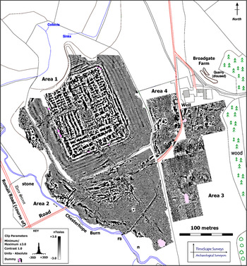
Closely constructed barracks, some of which are as little as 460 mm (18 in) apart may qualify for the term double. The buildings in the north of the fort appear to be less well built than those in the south and this latter area is also dominated by the later principia. Significantly the granaries and other buildings of a specific nature are sited to the south. Little space seems to be allocated to internal roads, and certainly buildings were constructed over any road that formerly led to the south gate. Importantly, the survey indicated possible evidence of a curtain wall at the bottom of the slope, outside the extant curtain wall.Footnote 63 This could suggest the presence of an earlier larger fort, and the survey evidence suggests a wall or some linear masonry structure approximately 2.5 m wide and quite discrete with well-defined margins. The small enclosure (or annexe) outside the south gate and surrounded by its own ditch could possibly have been used as a wagon park or for the storage of goods-in-transit and some comparison can be made with the annexe at High Rochester. This enclosure contains several long buildings, which may represent external storage or accommodation blocks. No evidence of any cemeteries was found as a result of the survey.
Possible sub-Roman civilian occupation is evident within the fort interior, which may have continued into the medieval period. Some extramural buildings can be seen towards the west close to the route of Dere Street, with a possible bath-house and civilian buildings present. There is also some evidence of later buildings, probably medieval, situated close to the fort (Area 4).Footnote 64
(6) Vindolanda (NY 769 663): (a) inside the third- and fourth-century fort: the main excavations during 2013 concentrated on the south-eastern quadrant of the last stone fort, constructed in c. a.d. 213 by the Fourth Cohort of Gauls. The excavations in this area discovered a series of late Roman and post-Roman structures buried close to the surface beneath mounds of fallen rubble immediately to the south of the praetorium. Below those levels were two partially preserved fourth-century barrack blocks, built along an east–west alignment (with the centurion's apartments facing the intervallum road) rather than along a north–south axis as found in the north-western and north-eastern quadrants of the same fort.Footnote 65 Although the fourth-century barracks were badly damaged by later post-Roman and stone robbing activities they produced a quantity of arrowheads (47) from a variety of different contexts as well as fourth-century pottery and other material. Notable artefacts included a small stone altar set up to the god Apollo and dedicated by Aprilis and a small jet medallion in the shape of a foot. A well-preserved nail-cleaning strap-end of late fourth-century date with a Christian carving on its front (a figure of a priest with robes, shepherd's crook and halo) was recovered from a barrack room.
Situated directly below the foundations of the fourth-century barracks were the remains of the primary a.d. 213 buildings which were set out to line up with the south wall of the praetorium. As with the fourth-century buildings above them, the third-century structures were constructed along an east–west alignment with drains and roads between them. The buildings were 24 m long by 5 m wide with mixed earth and flagged floors. These structures were only partially explored in 2013 and as such their primary function is yet to be determined. This question will be addressed in 2014.
(b) Vicus: in 2013 excavation continued and was completed in the area below the foundations of the third-century extramural settlement explored during 2012.Footnote 66 This work revealed aspects of a pre-Hadrianic extramural settlement constructed in the early years of the second century outside the northern defensive perimeter of the Period IV fort (c. a.d. 105–120) between that fort's northern ditch and the Stanegate road.
The buildings had been demolished/abandoned by a.d. 122 and were subsequently covered over by the upcast from replacement Period V fort's large western ditch which was situated to the immediate east of the area under excavation (examined during 2012). The demolition of the buildings coupled with a rapid covering of boulder clay from the ditch-digging left the area under anaerobic environmental conditions, allowing for the good preservation of organic remains from the structures. Two types of domestic dwellings were examined, the first was a series of circular huts and the other more traditional ‘Roman’ rectilinear buildings ( fig. 8). Both types had been constructed using wattle and daub and had been replaced or refurbished at least once during their lifetime, possibly at the same time. The excavations provided a wide variety of tightly datable and contextualised artefacts from the floors, pits and drains within and surrounding the wattle and daub buildings which included: over 80 shoes (men's, women's and children's), large caches of buried hazelnuts in sealed pits, preserved animal bones (cattle, sheep/goat, pigs, chickens, dogs and cats), brooches, perfume bottles, hairpins, beads, wooden combs, stylus pens, stylus tablets, an ink pen and ink tablet (from the final phase of the circular hut), and a large assemblage of pre-Hadrianic pottery.
Vindolanda: view, looking west, of Period IV (c. a.d. 105–120) pre-Hadrianic extramural buildings excavated in 2013.

(c) The field to the north of the site: excavations continued on from the work undertaken in 2012, moving the limit of the trench some 30 m to the west to allow further exploration of a series of early fort ditches running in an east–west direction. These ditches were first located during the excavations of 2010 and 2012.Footnote 67 In 2013 a series of impressive features was revealed which were later in date and situated above the earlier fort ditches. These features included another broad and deep ditch running east–west (4 m wide and 1.9 m deep) immediately to the south of a roadway on broadly the same alignment. This road may possibly have been an early line for the Stanegate road itself. The road had a lightly metalled surface, pressed into a clay foundation approximately 5 m wide, and was situated in a shallow cutting (up to 1 m deep and cut through clay). It is not yet clear whether or not the large ditch and roadway were contemporary with one another and it is hoped that further work in this area in 2014 will address this question. After this surface had been abandoned the road cutting/surface was filled in with clay and a later series of Roman features, including curvilinear ditches, a tile kiln and refuse pits, occupied the area.Footnote 68
CUMBRIA
(1) Low Side Quarter: 28 silver denarii: Nero (a.d. 54–68), 1; Otho (a.d. 69), 1; Vespasian (a.d. 69–79), 5; Vespasian for Domitian Caesar, 1; Domitian (a.d. 81–96), 2; Nerva (a.d. 96–8), 2; Trajan (a.d. 98–117), 8; Hadrian (a.d. 117–38), 3; Antoninus Pius (a.d. 138–61), 3; Antoninus Pius for Faustina I, 1; illegible fragment, 1. Deposited a.d. 161 or later.Footnote 69
(2) Maryport (?Alauna), Camp Farm: (a) work took place at two locations. At the first (NY 042 375) two trenches were opened to complete the fieldwork programme begun in 2011 on the findspot of the ‘Maryport altars’.Footnote 70 In 2013 the extent of the 1870s diggings was confirmed, and two outlying pits identified to the east of the main concentration. In 2011 it had been demonstrated that the pits discovered in the 1870s were part of the foundations of a major timber structure or structures; determining the extent and character of these additional pits was crucial to a better understanding of the form of these building works. A long linear feature, believed to mark a boundary of some sort, was also identified. This connected with another linear feature first detected in 2012 and found to contain Roman pottery of second-century date. A roundhouse with internal post-pits, which did not yield any dating evidence, was also found.
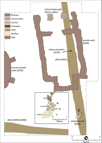
At the second location (NY 041 373) a new area was opened to allow the examination of a rectangular structure and a circular building discovered in 1880 by the antiquarian Joseph Robinson. Robinson's reports suggested that one or both of these structures had a cult function. The full extent of Robinson's rectangular building was exposed and this revealed just how much it had been damaged since it was cleared and photographed in the 1880s. It was confirmed that the rectangular building was a temple 13.9 by 7.9 m in size ( fig. 9). The building's entrance lay to the north-east and consisted of a porch with two columns in antis. To the south-west of the temple's foundations lay a collapsed section of its wall, sufficient to indicate that the elevation was constructed of local red sandstone, but that some elements, such as the cornice, may have been carved from yellow sandstone. The temple had been built over a V-shaped ditch, an action that clearly contributed to the instability of its walls. A square pit had been cut into the ditch and filled with cremated animal bone (all skeletal elements of a sheep/goat and one bird bone). This pit was dug prior to the temple's construction and may indicate a foundation ritual, performed prior to the erection of the building in the mid-second century a.d. Substantial ditches were identified in the area around the temple, and the eastern side of the circular building was exposed; these features will be investigated further in the 2014 season.Footnote 71
Maryport Temples Project: plan of the rectangular temple in Trench E.
(b) (NY 040 374): a community and research excavation, undertaken approximately 150 m north-east of the fort, in the heart of the extramural settlement, revealed the western edge of the cobbled road leading from the fort's north gate, with long, narrow building plots extending north-west, perpendicular to the road alignment. Following initial test-pitting, which demonstrated that Roman archaeology lay directly beneath a shallow depth of modern topsoil, a larger area was opened to investigate a complete stone (or stone-footed) strip building, c. 20 by 5 m, lying end-on to the road, with contemporary features and deposits in the back-plot to the rear ( fig. 10). The building appears to have comprised a row of three principal rooms, the easternmost of which may have been open (or could be opened-up) onto the street frontage. This room had clay floors and burnt deposits, though no hearths were found. The middle room had a heavy flagstone floor and yielded small amounts of probable smithing debris; the smaller back room has yet to be investigated in detail. It is apparent from areas of localised slumping that the building overlies earlier features, and earlier stratigraphy is visible elsewhere beneath the structure.
Maryport Settlement Project: interpretative plan of the principal archaeological features in the extramural area.
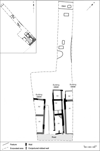
The rear of the plot was defined by a V-shaped ditch, 2.4 m wide and 0.85 m deep, and several possible wells or cisterns were also present in this area, though many more features remain to be excavated. The absence of coins of the late third to fourth century a.d., and the presence of only small quantities of contemporary pottery, confined to a handful of features, is consistent with the wider evidence from extramural settlements in the North, many of which seem to have either contracted considerably, or been abandoned altogether, long before the associated forts went out of use. The excavation will be completed in a second fieldwork season in 2014.Footnote 72
(3) Ravenglass (SD 087 959): 2013 saw the start of a programme of excavation, fieldwalking and geophysical survey as part a community archaeology project.Footnote 73 The site had been the subject of excavation in the 1970s, and a geophysical survey in 2011. The 2013 geophysical survey confirmed the basic picture provided by the 2011 survey regarding the probable extent of the Roman activity in the fields east of the fort.Footnote 74 It also suggests that more survives in the interior of the fort than had previously been supposed. The survey revealed that there were buildings fronting onto streets across a larger area than previously thought; these findings were subsequently supported by the excavations which recorded evidence for timber buildings and industrial activity, including iron- and possibly lead-working.
Roman coins and various types of Roman pottery, including imported fine wares, indicated that the parts of the vicus which were examined fell out of use towards the end of the third century. Ceramics recorded included Dressel 20 amphorae, Mancetter-Hartshill mortaria, samian ware and a sherd from a Moselle beaker. A small number of local wares, possibly from the Muncaster kilns, were also recovered.
It seems likely that the road running east-north-east from the fort is the main road to the forts at Hardknott and Ambleside, and also to the Muncaster/Park House tile and pottery works.
Fieldwalking and earthwork survey were also undertaken to examine the site for previously unrecorded features, and to assess the impact of coastal erosion. A second season of community excavation and survey will be carried out in 2014.Footnote 75
COUNTY DURHAM
(1) Binchester (Vinovia) (NZ 2102 3134): a fifth season of work in the new programme of excavation took place in 2013.Footnote 76 At the east corner of the fort the finely dressed masonry of the inner face of the fort wall was revealed along with the severely robbed remains of the angle-tower. A short distance from the latter along the north-east defences and attached to the back of the fort wall was a modest latrine block. This measured 4 by 3 m internally and was equipped with a doorway in its north-west wall. Resting on its flagged floor were two monolithic stone troughs. To ensure adequate flushing of this facility the drain running along the edge of the intervallum road had been connected to that passing beneath the floor of the latrine. This exited through the lower part of the fort wall via a neatly turned arch to discharge into a circular chamber standing on the berm discovered during excavations in 1937.
It has now become clear that the building on the opposite side of the intervallum road began life as a cavalry barrack akin to those found at Wallsend. Nearly 12 m wide originally it was divided into contubernia 4.20–4.40 m wide. Each contubernium has an inner and an outer room, the latter, facing out onto the intervallum road, clearly providing accommodation for horses and equipped with rough surfacing and a slot or drain. An area paved with large slabs afforded a path to the troopers' living room at the rear which contained a hearth. The outer 12 m or so of the building, next to the north-east defences, was occupied by the decurion's living quarters. In a later phase the barrack was reduced to a width of c. 7.5 m. Neither phase is as yet closely dated but both are likely to belong within the fourth century. Elements of earlier phases are also beginning to appear while the undulating form of the outer wall of the building on the north-west side again testifies to significant subsidence.
In 2013 work in the area beside Dere Street south-east of the fort concentrated on the structures thought to be part of the regimental bath-building ( fig. 11). Two rooms of the primary phase lie wholly or largely within the trench; one a long, narrow corridor-like chamber and the other — to the north of it — a large room of square plan with a raised stone bench along its walls. The latter may well have functioned as the apodyterium or changing-room from which access was gained via the corridor to the main bathing facilities. Also just within the trench is one wall of another chamber opening off the corridor and intruding slightly into the chamber to the north. The building had a complex structural history as revealed by blocked doorways and window embrasures in its impressively well-preserved fabric which features walls standing to a height of approximately 2 m above floor level. Over the course of several centuries the floor levels inside the building appear to have remained more or less the same but successive reconstructions of neighbouring buildings and numerous resurfacings of Dere Street resulted in the ground surface around it rising by about 1 m. At a late stage in the building's history it became redundant and, apparently with its superstructure still standing, was used thereafter as a giant refuse receptacle. One of the objects retrieved from this refuse dump was a small stone head carved in a style reminiscent of that representing Antenociticus found at Benwell. Unlike the latter the head found here had only ever been a head not part of a statue ( fig. 12). Later still a substantial, if crudely built rectangular structure, roughly 6 by 4 m in size, was erected in front of the bath-building and encroaching upon the edge of Dere Street. Its footings were formed of large stone slabs which in many cases had had small holes drilled into them, presumably to form sockets for tenons associated with a timber superstructure. Buildings with exactly the same type of footings have been found at several forts on Hadrian's Wall, notably Haltonchesters, where they were dated to the last third of the fourth century and termed ‘park-railing’ type footings. Equipped with a flooring of large stone slabs this structure was subsequently extended northwards. Two layers of substantial paving laid over the rubbish deposits in the neighbouring chambers in the bath-building may be contemporary with one or more phases of this late structure, perhaps indicating that it had been brought back in to use one last time before its final abandonment. The deposits overlying the latest paving included large quantities of animal bone just like those associated with the latest activity elsewhere on the site.
Binchester: view across bath-building showing corridor with (?)apodyterium beyond and, to the left, chambers appended to the front of building in later phases.

Binchester: stone head. (Photo: Jeff Veitch for Archaeological Services Durham University)

After the end of the main excavation season two altars were recovered from a small alcove in the north corner of the (?)apodyterium. The larger example, standing on the floor of the chamber, was totally plain though traces of render suggest it may have had a painted dedication at one time. The other altar, found adjacent to the first but standing on the stone bench at the foot of the wall, carries a dedication by a veteran of the ala Vettonum. Although this unit has long been known to have been stationed at Binchester, the dedication is of more than usual interest because it attests the existence of an architectus on the staff of an auxiliary regiment.
(2) Greta Bridge (NZ 0844 1320): topographic, geomagnetic and resistivity surveys were carried out on the fort site here as one of a series of ‘community archaeology’ projects within the HLF-funded ‘Heart of Teesdale’ Landscape Partnership scheme.Footnote 77 The work revealed some details of the street grid and the outlines of individual buildings but the production of a definitive plan was not possible owing to the complexity of the results caused by a number of post-Roman activities across the site, including cultivation, the importation of soil and groundworks related to the construction of a golf course. The survey area included the land immediately beyond the south-western defences but no traces of vicus buildings were detected. It seems probable that substantial sections of the north-eastern defences have slipped down the hillside towards the River Greta.
DARLINGTON
(1) Piercebridge (?Morbium), Garden Centre (NZ 2116 1616): excavation in advance of the construction of new facilities at these premises, around 300 m north of the late fort, exposed a length of a road known from earlier investigations to head westwards from Dere Street into an area where burials were found in the nineteenth century. In this sector the road took the form of a gravel-surfaced hollow way. This had been filled in during the late second or early third century a.d., following which an area of surfacing possibly associated with some form of structure had been constructed over it at the western end of the site. A substantial layer of occupation material had then accumulated across the area. This produced abundant fragments of third-century pottery including sherds from at least three head-pots of North African type. A further head-pot containing a cremation burial was found in one chamber of a two-chambered stone-lined cist in the eastern half of the site. This had been truncated by post-Roman ploughing, leaving only the base of the head-pot with the chin and lips intact. The other chamber contained an urnless cremation.
The southern edge of a large ditch was found at the northern boundary of the site running roughly parallel with the hollow way. Pottery associated with a gully, refuse pits and patches of surfacing represented activity continuing into the fourth century.Footnote 78
NORTH YORKSHIRE
(1) Aldborough (Isurium Brigantium) (SE 4060 6632): fieldwork in 2013 comprised four principal elements. First, the magnetometer survey of the intramural area was completed, with further areas covered in the northern-eastern and central parts of the walled area, and on the eastern defences.Footnote 79 Second, the magnetometer survey of the extramural zones covered very large areas to the east and north of the town, reaching the River Ure in this direction.Footnote 80 The results from this work were exceptional, providing clear plans of the outer defences, extramural buildings, enclosures and funerary monuments. Most significantly, the work to the north revealed the location of the Roman bridge over the Ure, whilst aerial photographs located a probable fort contemporaneous with the town in this area.Footnote 81 Third, further Ground Penetrating Radar survey work was completed, providing further information on buildings in the centre and west of the intramural area.Footnote 82 Finally, detailed study of the finds from the field walking undertaken by Professor Jennifer Price in the 1980s provided valuable information about the chronology and character of the area immediately to the north of the walled area, which had its floruit in the Antonine period and seems to have been abandoned when the defences were remodelled in the mid-fourth century a.d. The data from fieldwalking have been incorporated into a GIS which is also integrating the results of the geophysical survey.Footnote 83
(2) Barlby, Turnhead Farm (SE 63258 35142): an archaeological evaluation consisting of geophysical survey, which suggested the existence of a complex site, followed by trial trenching was undertaken in advance of proposed residential development.
Many of the features identified in the trial trenches were boundary ditches relating to the system of enclosures shown on the geophysical survey ( fig. 13).Footnote 84 There was also considerable evidence for domestic or settlement activity with pits and a ring gully. The numerous gullies were suggestive of minor boundaries connected with domestic occupation.
Barlby, Turnhead Farm; geophysical survey plot.

Assessment of the pottery assemblage has shown there to be no pre-Roman material and no material in the Iron Age tradition. The earliest activity dated from a.d. 70–100 with a possible focus of early second-century activity around Trenches 5 and 7. There is a major increase in activity in the mid-second century and this apparently continues with some variation into the early fourth century, with a decline in the late fourth century.
The incidence of decorated samian and amphorae at the site is much higher than would be expected for a Roman ‘small town’ and strongly suggests a military element in the supply. The ratio of fine wares to coarse wares is also much stronger than that for a rural site or a villa and is within the urban and military range. The presence of face pots (one of which bears a striking similarity to images of Septimius Severus) suggests a connection to the Imperial family, through a military and/or official status, reinforcing the site's importance. The concurrence of face pot and samian sherds together in a ditch terminal in Trench 16 is an example of ‘structural deposition’ as part of a ritual, perhaps connected to a military or official function. Possibly relevant to this suggestion is the strategically important location of the site, on a bluff overlooking the River Ouse and alongside the route that followed the river's east bank.
Analysis of the ceramic building material also reinforces the site's significance. The presence of a high status structure with a hypocaust is suggested, although the relatively low quantities of material suggest that it may have been small. The absence of flue tiles suggests that this structure was situated away from the excavated areas. Fired clay fragments show that there were buildings with wattle superstructures and external planking; they were roofed with both ceramic and stone roofing tile.
Iron-smelting slag and a piece of possible oven-lining were located and while this is not definitive proof that metal production was carried out at the site, it is suggestive of pre-industrial iron-smelting or smithing in the vicinity. The plant remains from the site show a variety of domestic and agricultural activities such as cooking and cereal processing. The plant remains also suggest that some of the ditches were subject to water-logging, both in the Roman period and perhaps more recently.Footnote 85
(3) Catterick (Cataractonium), Bridge Farm Quarry (SE 2358 9917): archaeological monitoring of mineral extraction to the east of the Roman temporary campFootnote 86 has, from 2012, produced notable quantities of Roman period finds from a number of broad shallow ditches or channels. The second- to fourth-century pottery assemblage includes samian, amphora, local mortaria and fine wares, Nene Valley colour-coated ware, Crambeck grey ware and Knapton/Huntcliff-type gritted wares.Footnote 87 The whole assemblage, which includes opus signinum and fragments of several box-flue tiles of probable late first-century a.d. date, is very water-worn and could derive from a bath-house.Footnote 88 Nearly 600 very fragmented and fragile animal bones and over 20 disarticulated human bones have also been recovered. One of the latter was radiocarbon dated in the range cal a.d. 249–391 at 95% confidence (2 sigma). To date there is no evidence for any structures or other convincing settlement evidence. The circumstances of the deposits and condition of the finds suggest that they may be the result of marginal tipping which has periodically been washed into temporary flood channels in this loop on the River Swale.Footnote 89
(4) Malton (Delgovicia), Jockey Rehabilitation Centre (SE 7940 7220): an open-area excavation of c. 0.725 ha was undertaken on the site which is located 750 m north-east of the Roman fort and associated civil settlement.Footnote 90
The presence of a trapezoidal enclosure at the site was established by aerial photography in the 1970s and augmented by geophysical survey in 2004. Trial trenching in 2012 confirmed the presence of archaeological deposits associated with the enclosure. The enclosure was 70 m in length and had an internal division. The open-area excavation examined the southern, eastern and western boundaries of the enclosure, along with possible internal activity. The northern boundary lay outside the area of excavation.
A significant assemblage of Romano-British pottery was recovered, along with quantities of animal bone. The enclosure appears to have had some form of use throughout the Roman period due to the date range of the pottery from the late Iron Age/early Roman period to the fourth century.
The form of the enclosure suggests an origin as a possible temporary camp, possibly associated with the establishment of the fort. A continuing military function for the site may be indicated by the large amount of horse bone recovered; it is suggested that this temporary camp was reused as part of a stock-holding enclosure and was possibly associated with buildings located 50 m to the east.Footnote 91
(5) Pickering, Newbridge Quarry (SE 7990 8760): excavations in advance of mineral extraction, ongoing since 1999, continued the investigation of enclosures and features flanking an extensive north–south ditched trackway.Footnote 92 The most recent work has seen the excavation of a potential Bronze Age ring barrow and part of an enclosure that has produced pottery dating from the Late Iron Age to the second century a.d. An un-urned human cremation from the trackway is yet to be dated, but previous work to the south has provided evidence for 23 similar cremations of Roman date.Footnote 93
(6) Well, The Lodge, Holly Hill (SE 26464 81805): a test pit was excavated and a watching-brief maintained during ground works associated with the extension of The Lodge.Footnote 94 The Holly Hill area of the village of Well has been known to be the location of a group of Roman buildings since the eighteenth century.Footnote 95
The 2 by 2 m test-pit revealed a 0.5 m-thick layer of demolition material directly overlying natural boulder clay; it contained sandstone rubble, Roman tile and a large number of loose tesserae of grey sandstone and red ceramic material (tile). It was interpreted as a levelling deposit associated with the building of The Lodge in 1860, and derived originally from the destruction or demolition of parts of the Roman building. The tesserae are clearly from a tessellated pavement recorded a few metres to the north.Footnote 96 The subsequent watching-brief confirmed that the area immediately to the east of The Lodge represents a zone within which archaeological deposits have been destroyed. Immediately to the south of The Lodge, however, (at the extreme limit of the recent works) the opus signinum floor of a Roman building survives in substantially good condition, covered by 0.3 m of the mortary, rubble-filled soil general over this part of the site.
The Roman remains at Well are often assumed to be those of a villa. This should not be taken for granted; a temple or shrine associated with a water deity would be a reasonable alternative. Such a temple might also provide an appropriate context for a major sculpture found in the village.Footnote 97
EAST RIDING OF YORKSHIRE
(1) Bempton: two illegible burnt and fused silver denarii.Footnote 98
(2) Beverley: 642 radiates: Gallienus and Salonina (a.d. 260–8), 77; Claudius II (a.d. 269–70), 50; Divus Claudius, 10; Quintillus (a.d. 270), 5; Aurelian (a.d. 270–5), 1; Tacitus (a.d. 275–6), 8; Probus (a.d. 276–82), 12; Postumus (a.d. 260–9), 3; Victorinus (a.d. 269–71), 109; Tetricus I and II (a.d. 271–4), 298; uncertain Gallic Empire, 48; irregular, 1; uncertain, 20. Deposited a.d. 282 or later.Footnote 99
(3) Easington, Beacon Lagoons (TA 4100 1600): excavations were undertaken to mitigate the impact of the Easington Wetlands Project. The site, also notable for a Late Neolithic/Early Bronze Age camp, produced evidence for a Romano-British field-system that was in use up to the fourth century a.d. The potteryFootnote 100 included native hand-made material as well as grey ware. The grey ware component of the assemblage is of some interest in that its fabrics and form types suggest production in the Doncaster or Trent Valley area. Moreover, they belong to a period before the production of the ubiquitous regional grey ware from around Holme-on-Spalding Moor in the third and fourth centuries.Footnote 101
(4) Holderness, Westermost Rough (TA 3075 3255–TA 1668 2925): archaeological investigations were carried out along a 15 km cable route between Salt End and Tunstall. Trial trenching and set piece excavations were carried out at 40 locations targeting features identified from cropmarks and a full geophysical survey of the entire corridor. The excavations have identified five significant archaeological sites, including an unenclosed Iron Age settlement and two Romano-British settlement enclosures dating from the later Iron Age to the second century a.d. Over 8,500 sherds of hand-made and wheel-thrown pottery, 3,400 animal bone fragments, and several flint and metal items, including a pair of Roman tweezers, have been recovered. A single crouched burial has a radiocarbon date range of 359–104 cal b.c. at 95% confidence.Footnote 102
(5) Middleton: base silver denarius of Caracalla (a.d. 198–217). Abraded flat on its reverse leaving the obverse displaying a beardless effigy of Caracalla as Augustus. It has been mounted within a silver mount decorated with eight evenly-spaced circumferential ribs. Deposited after a.d. 209.Footnote 103
(6) Wilberfoss: 4 radiates and 9 nummi. Radiates: Tetricus I or II (a.d. 271–4), 1; ?Allectus (a.d. 293–6), 1; uncertain, 2. Nummi: a.d. 310–13, 1 (uncertain mint); a.d. 317–24, 1 (uncertain mint); a.d. 324–9, 1 (London); a.d. 330–5, 3 (uncertain mint); a.d. 348–50, 3 (uncertain mint). Deposited a.d. 350 or later.Footnote 104
LEEDS
(1) West of Tadcaster (SE 44 42): excavations along the line of a new buried power cable allowed the investigation of parts of several cropmark complexes of Late Iron Age and Roman date, as well as two points along the route of Roman road Margary 72b, and led to the discovery of a section of a metalled double-ditched trackway within one of the field-systems. The course of road 72b is known and extrapolated principally from cropmarks. Recent geophysical surveys have suggested that the agger is better preserved in pasture fields, and this is borne out in some fields where slight earthworks can be seen. Excavations in a cultivated area revealed that the evidence for the road had largely been eradicated, except for a line of quarry pits along it southern edge. Even in one of the better-preserved areas the survival of the agger and the flanking ditches was minimal, and limited to the field margin. The discovery of a heavily cobbled stretch (c. 70 m) of a sinuous double-ditched trackway within an irregular field-system is unusual. The metalling corresponded with a low-lying stretch of trackway at a point where it descends off the Magnesian Limestone on the approach to a stream crossing. Although not constructed on an agger, its construction and preservation are far better than that seen in the remains of the 72b.Footnote 105
WAKEFIELD
(1) Castleford (Langentium), Castleford Bus Station (SE 4247 2554): an evaluation of six trenches and a watching-brief were undertaken within the known area of the vicus at Castleford. A number of Romano-British features were recorded, including ditches, a possible beam slot or ditch, a pit and an animal burial. The finds consisted mainly of pottery, which included grey wares, oxidised wares, white wares and Black Burnished ware, along with samian and amphorae. The features and finds were of later first to second century a.d. date. A buried soil containing further pottery sealed the features and may indicate the abandonment of this part of the vicus.Footnote 106
DONCASTER
(1) Doncaster (Danum): (a) Roman Ridge Roman road (SE 5436 0557): a watching-brief was undertaken during groundworks associated with the creation of a cycleway and footpath along the earthwork agger of the Roman Ridge Roman road (Margary 28b),Footnote 107 which runs for 5 km between Scawsby and Adwick-Le-Street. The works involved the localised removal of a thin layer of topsoil from the existing path that runs along the top of the earthwork, and the excavation of 16 small pits for the installation of gates and handrails. The main body of the agger was shown to consist of orange-brown silt, probably sourced as local soil, but the surface of the Roman road was not encountered, suggesting that it had eroded away, at least in the areas observed.Footnote 108
(b) Hatfield Lane (SK 6320 0644): prior evaluation by geophysical survey and trial trenching identified enclosures within the ‘brickwork’ field-system north of Armthorpe that had not been identified on cropmark plots. Subsequent excavation focused on one enclosure which was to be impacted by development.Footnote 109 Although severely truncated, the site has produced a notable assemblage of Roman pottery, much of it in large pieces, and was clearly part of a settlement. As well as grey ware the pottery assemblage includes two near complete samian bowls. Organic material did not survive in the sandy soil, but another notable find was the complete (fragmented) topstone from a flat hand-quern, the key elements of which are the central ‘bar’ or ‘rib’, the perforated central ‘eye’, and slight asymmetry in the placing of the opposing feed-pipes. Such querns have been seen to have strong links to Pennine military sites and are usually dated to pre-a.d. 250.Footnote 110
(c) Sandall Stones Road, Kirk Sandall (SE 6072 7140): a trial trench evaluation of a previously developed site located within the area of the classic ‘brickwork’ field-system around Edenthorpe,Footnote 111 and c. 0.5 km to the north of the recently discovered Roman fort at Long Sandall,Footnote 112 revealed several linear ditches that are typical of the field-systems found elsewhere in the area.Footnote 113 Pottery included a notable quantity of hand-made material that could be of pre-Roman or Roman date. More definite Roman period material dated from the second to fourth centuries, with the majority of the material being of third-century date. Mancetter-Hartshill mortaria, Black Burnished wares and local grey wares were all represented.Footnote 114
(2) Tickhill: 48 coins: 1 silver denarius, 1 bronze sestertius, 1 bronze radiate and 45 bronze nummi. Denarius: Commodus (a.d. 180–92) for Crispina, 1; sestertius: uncertain Antonine empress, 1; radiate: Victorinus (a.d. 269–71), 1; nummi: a.d. 330–5, 1 (Trier); a.d. 347–8, 2 (Trier and irregular); Magnentius (a.d. 350–3), 13 (Amiens, 1; Trier, 1; uncertain, 10; irregular, 1); a.d. 353–4, 26 (Lyon, 1). Deposited a.d. 355 or later. A first- or second-century copper-alloy brooch fragment and grey ware pottery sherds were found alongside the coins but are probably unrelated. It is also less likely that the Antonine period coins are associated with the later bronzes.Footnote 115
SHEFFIELD
(1) Whirlow Hall Farm (SK 3123 8318): a community archaeology project was undertaken in 2011.Footnote 116 Geophysical survey revealed a large, ditched rectilinear enclosure measuring some 70 m in length with two opposed entrances. Excavation focused on the western entrance and revealed two phases of use, with the second phase including the construction of a low drystone wall against its inner face. A radiocarbon date from the lower ditch fill suggested that the enclosure, which may represent a farmstead, was constructed in the mid to late Iron Age, although the fill of the second-phase ditch contained abundant Roman ceramics dating to the late first and early second centuries a.d. Part of a rectangular internal building was located consisting of a stone-built foundation with an internal paved and beaten earth floor. Roman period ceramics came from this internal floor deposit. The western gateway appears to have had a double entrance and a thick metalling layer had been constructed over the entrance causeway and appears to extend across most of the interior not taken up by internal buildings. Roman period ceramics were also found within the metalling layer.Footnote 117
CHESHIRE WEST AND CHESTER
(1) Chester (Deva): (a) Chester Zoological Gardens (SJ 4090 6990): a watching-brief maintained during topsoil stripping associated with the development of a c. 10 ha extension to the zoo into former agricultural land revealed fragmentary evidence of a former field-system consisting of shallow ditches. Definitive dating evidence was absent but the lack of any relationship with the modern field pattern or that depicted on historic maps, the regular layout of the ditches, and the similarity to better-dated systems recognised during recent work on the outskirts of Chester at Saighton and Chester Business Park are suggestive of a Roman date.Footnote 118
(b) St Martin's Lodge (SJ 4029 6598): a programme of excavation and archaeological monitoring produced evidence of four phases of Roman activity. The first phase consisted of a ditch and a cobble road surface orientated NNW to SSE, all above a pre-Roman turf horizon. This horizon showed clear signs of land clearance evidenced by in situ tree burning and plough marks. A group of postulated graves, which were below the level of development impact, may also be associated with this phase. A group of floors, wattle and daub walls, and post pads indicates a building sequence probably contemporaneous with the Phase I road. Ceramics gave a date range of a.d. 70–110. None of these features' orientations conform to the Roman fortress street-grid, or the known street-grid of the civilian settlement. Other contemporaneous structures on the site with construction and use in the mid to late first century a.d. and disuse in the early third century are all located north of a palaeochannel. These included timber-framed buildings which defined a civilian exclusion zone c. 50 m wide between the fortress outer defences and the civilian settlement. These buildings are interpreted as a stable block and were initially built in timber in the first century, then stone in the early second century. No Roman stratigraphy was found immediately south of the palaeochannel which survived to be infilled from the mid-second century.
Phase II activity is represented by an enclosure ditch, a roadside ditch and the agger of a road in the main excavation area, which may have enclosed activity areas perpendicular to the Phase I ditch. Spot dates on ceramics for the onset of silting in the enclosure ditch gave a range of a.d. 120 and later, and suggested the roadside ditch was silting up by the mid to late fourth century. It is highly probable that these features represent part of a project to extend the civilian settlement southwards over the top of the infilled palaeochannel in the late third to fourth centuries a.d. A sequence of floors, beam-slots and post-holes, representing the rebuilding of a corner of a timber-framed building, was contemporary with this phase.
Phase III is characterised by demolition and abandonment of this part of the Roman civilian settlement. Ceramic dating for this phase was third to fourth century a.d.
Phase IV is represented by a well-constructed, robbed-out, clay-bonded sandstone wall suggestive of late Roman construction, c. 9 m north-east of the north-eastern edge of the Phase II road agger, and a massive dry-stone wall. These features suggested that the settlement had extended to the north-east over time.Footnote 119
WARRINGTON
(1) Warrington, Southworth Quarry, Winwick (SJ 6227 9416): excavation in advance of a further phase of quarrying investigated a c. 60 m square enclosure visible on aerial photographs and recorded in the Cheshire Historic Environment Record.Footnote 120 An earlier phase of desk-based assessment and field evaluation in 1993 had confirmed the survival of sub-surface features and suggested that the enclosure was of Roman date. Removal of the topsoil across the whole of the enclosure, apart from the western ditch which had already been quarried away, confirmed the Roman date and suggested that occupation occurred in the second century a.d. There was evidence that the ditches had been re-cut but the extensive plough damage meant that the shallow pits, post-holes and gullies that were present in parts of the interior were difficult to interpret.Footnote 121
NORTH LINCOLNSHIRE
(1) Kirmington, Humberside Airport (TA 100 101): an evaluation was undertaken on the site of a new Search and Rescue facility where a buried fourth-century Roman plough soil was encountered. The pottery recovered consisted of late third- to fourth-century North Lincolnshire grey wares, fourth-century Swanpool (Lincoln) mortaria, and Dalesware vessels. A small group of Oxford red-coated bowl forms was also present in the excavated assemblages. The presence of Roman plough soils in this area relates to the known Romano-British settlement and Roman fort that is situated to the north-east of the site and is located partially within the Airport boundary.Footnote 122
NORTH-EAST LINCOLNSHIRE
(1) Hatcliffe: two base silver denarii: Septimius Severus (a.d. 193–211), 2. Deposited a.d. 197 or later.Footnote 123
LINCOLNSHIRE
(1) Grantham: (a) Rectory Farm (SK 8939 3700): an evaluation was undertaken in an area where a geophysical survey had revealed a complex of boundary ditches, enclosures and other features; 12 of the 13 trenches were targeted on geophysical anomalies. The evaluation identified a complex of ditches and gullies in the north-western, more elevated, part of the site containing Romano-British pottery, animal bone and smithing slag, as well as environmental evidence, suggesting settlement activity in this area. A later quarry pit among these features contained residual Romano-British material, including possible rubble from a demolished building, although no worked stones or mortar were observed; a single Romano-British tile was recovered from an adjacent ditch. The pottery, of second- to third-century date, consists predominantly of grey wares, with jars and bowls represented; fine wares are limited to two body sherds of Nene Valley colour-coated ware and a sherd of Spanish Dressel 20 amphora.Footnote 124
(b) St Catherine's House (SK 918 356): a detailed watching-brief was carried out during the demolition and redevelopment of St Catherine's House and the surrounding gardens. Several buried subsoil and cultivation deposits were encountered across the site that were sealed by later medieval settlement activity. Several late Iron Age pottery sherds were recovered in two phases of Roman subsoil deposits dated to the second and fourth centuries a.d. The majority of the pottery assemblage consisted of local Lincolnshire and Nene Valley grey wares that were interspersed with Central Gaulish samian, Mancetter-Hartshill mortaria and local fine wares. Accompanying the pottery assemblages was found a small amount of domestic animal bone and the humerus from an adult human. The condition of this bone indicates that it had not travelled far from its original burial suggesting the presence of a second-century inhumation within the environs of the site.Footnote 125
(2) Horncastle: gold solidus of Honorius with gold suspension loop (a.d. 402). The coin has been modified to form a decorative pendant probably during the second half of the seventh century, when gold disc pendants were a common form of female jewellery.Footnote 126
(3) Lincoln (Lindum), Newport (SK 9772 7277): a three-year seasonal research and training excavation undertaken between 2010 and 2012, together with excavation and observations made in advance of construction work for a new university library building in 2011, found evidence for Roman occupation. The site was immediately adjacent to the Roman road known as Ermine Street, and some 650 m north of the Newport Arch, the northern gateway of Lindum Colonia. Prior to excavation a resistivity survey was undertaken which indicated a range of linear anomalies taken to represent wall alignments of both medieval and Roman date.
Two large open areas were excavated and watching-brief observations were also made; in addition a smaller trench was positioned to investigate the relationship of the site to Ermine Street. The earliest activity on the site consisted of a small number of shallow limestone quarry pits with backfills dated to the mid-second century a.d. At the western limit of the site a well-compacted gravelled surface was identified as the eastern edge of Ermine Street. Immediately to the west a large shallow roadside ditch ran north–south and cut into the underlying natural limestone brash; the ditch was some 2 m wide and 0.5 m deep.
At some time around the mid-second century a.d. the roadside ditch was replaced by a masonry culvert. A gravel surface, interpreted as a lane or alleyway, ran from the eastern side of the culvert for at least 35 m to the east where it joined a larger yard area. The culvert appeared to remain in use until the late third century a.d. when it was filled in and a layer of very compact pebbles in a sandy matrix was laid across the entire area. The lane to the east demonstrated a sequence of further resurfacings until the fourth century a.d. when it went out of use.
A masonry building, partially excavated in the 1970s and 1990s,Footnote 127 lay to the north of the lane. It was shown to be rectangular in plan and had external dimensions of approximately 30 by 9 m. Constructed in the late second century a.d., and possibly replacing an earlier timber structure, its eastern end was rebuilt during the third century a.d. Occupation of the building, and the site, ended at some point in the fourth century a.d. Evidence for the internal structure of the building indicated that at least four rooms with clay and mortar floors were present. The westernmost room, at the frontage with Ermine Street, had been decorated with relatively poor quality painted plaster.
In the room immediately to the east, taken to be the central room of the building, a group of up to four very small, possibly ‘miniature’, pots in a sandy cream ware fabric of mid to late second-century date was found buried as a ‘structured deposit’, possibly a foundation deposit, within the primary floor make-up layer near to an area of burning interpreted as a central hearth.
To the south and east of the building a yard surface of well-laid limestone cobbles was dated to between the late second and late third centuries a.d. Two ovens, probably utilised for domestic baking, were found at the northern limit of the yard. Following disuse one oven was cut through by a detached latrine structure. The pit of the latrine was backfilled in the late third century a.d. and the area became the focus for extensive cutting and re-cutting of refuse pits of medieval date. Further east fence alignments, later replaced by small roughly-built limestone walls, were interpreted as four animal enclosures originating during the third century a.d.
The earlier investigations had concluded that the building and other features represented a farm. The range of structural, artefact and environmental information recovered from the current work suggests this is unlikely. The absence of key indicators related to agricultural and animal husbandry activities together with the range of artefacts, such as significant numbers of gaming counters and ceramic fine wares, suggests that a more likely interpretation is a tavern or hostelry providing services for travellers arriving or departing the city. The site ceased to be occupied at some point during the fourth century a.d. at which time an extensive layer of organic-rich refuse type material accumulated, particularly over the central part of the masonry building.Footnote 128
(4) Ludborough, Damwell Farm (TF 3000 39709): a geophysical survey of c. 7 ha in extent was undertaken on arable fields proposed as the site of a wind farm. The site and its immediate environs have revealed, as cropmarks, a series of enclosures, roundhouses and pits of postulated Romano-British date. The presence of fourth-century coins and pottery from the site suggests this settlement continued into the late Roman period. A gradiometry survey was implemented that showed linear and rectilinear positive anomalies, with semi-circular-shaped anomalies possibly representing hut circles.Footnote 129
(5) Mumby, Mumby to Chapel St Leonard's main replacement (TF 5179 7462): archaeological monitoring revealed a large pit containing briquetage, in addition to two undated but possibly associated smaller pits and two boundary ditches, in an area of cropmark features. This part of the Lincolnshire Marsh is known for its extensive salt-making industry, concentrated in the area between Hogsthorpe and Ingoldmells. The briquetage consists of supports, predominantly pedestals, a single spacer-clip, a small number of fragments tentatively identified as container body sherds, and a sub-rectangular flat object or slab. Although not directly associated with datable pottery, this material indicates that marine salt production was undertaken within the vicinity of the site during the Roman period.Footnote 130
(6) Sleaford, Cranwell Booster Station, Byard's Leap (SK 9904 4949): archaeological monitoring revealed deposits shown to be the limestone rubble core and gravel metalled surface of a Roman road. The surviving camber proved to be 0.35 m thick and at least 14 m wide. These deposits are consistent with the descriptions of Ermine Street from previous archaeological monitoring conducted to the north of the site. No roadside ditch was encountered to the east of the Roman road.Footnote 131
(7) Stamford, Ryhall Road, new Stamford AFC stadium (TF 033 085 centre): excavation revealed an area of late Iron Age and Roman landscape bounded by large parallel east–west ditches, within which was an enclosure with a single roundhouse and, to the east, two mid-second-century pottery kilns ( fig. 14). The main phase of settlement activity seems to end in the early post-conquest period, with the backfilling of the enclosure, roundhouse and southern boundary ditch, into which an ironworking hearth was cut. The northern boundary ditch was maintained, going out of use during the later second or third century a.d. On the basis of the wasters within the two pottery kilns, they belong to the Bourne-Greetham industry producing distinctive shell-tempered jars, known from two other kilns to the north.Footnote 132 However, the pottery waste also included small numbers of grey ware jar types similar to those produced in the Lower Nene Valley in the middle of the second century. The floor of one of the kilns had been supported by two limestone blocks, set in parallel centrally in the chamber along the long axis of the kiln, a feature of the so-called ‘Linwood-type’ found in Lincolnshire — the nearest at Colsterworth about 8 miles north along Ermine Street.Footnote 133
Ryhall Road, Stamford excavation plan.

NOTTINGHAMSHIRE
(1) Ollerton: eight AR denarii up to Antoninus Pius are addendaFootnote 134 to earlier finds, the hoard now totalling 425 coins with a deposition date of c. a.d. 180.Footnote 135
(2) Radcliffe-on-Trent, land at Shelford Road (SK 6560 4000): an evaluation of 23 trenchesFootnote 136 revealed features detected by an earlier geophysical survey (by GSB) which had identified two large overlapping enclosures, as well as other ditches and pits, in the western half of the site. The evaluation indicated that these were part of a late Iron Age/early Romano-British settlement. Trench 32, at the intersection between the two enclosures, showed that the southern enclosure was stratigraphically later, indicating that the settlement shifted southwards, although there were no clear differences between the small finds assemblages from the two enclosures. Many of the ditches showed signs of recutting. Shallower gullies and ditches formed small internal boundaries within the enclosures, and were particularly prevalent in the southern enclosure where a concentration of charred crop-processing waste (in Trench 28) points to occupation within the enclosure. The pottery assemblage and complete copper-alloy, one-piece Nauheim-derivative brooch point to occupation of late Iron Age/earlier Romano-British date (late first century b.c. to mid/late second century a.d.).
DERBYSHIRE
(1) Derby, Little Chester Roman fort (SK 35325 37540): a series of evaluations was undertaken on and adjacent to the site of the Roman fort at Little Chester to inform design proposals for new flood defences along the River Derwent. The Roman fort (Derventio) was established c. a.d. 80 occupying a strategic location at an important crossing point of the River Derwent and the junction of several Roman roads including Ryknield Street. A large civilian settlement was associated. The first evaluation was intended to establish the precise alignment of the defensive ditches associated with the fort in order to minimise any impact of the proposed scheme on the monument. Three trenches were targeted on the projected course of the ditches along the western side and around the north-eastern corner of the fort, where their precise route was uncertain.
A 3 m-wide, flat-bottomed ditch exposed to the west of the fort had been damaged by post-medieval agricultural practices, but was apparently of a form inconsistent with a Roman defensive feature. The trenches placed adjacent to the north-eastern corner of the fort, however, revealed three ditches of typical Roman military form. The ditch closest to the fort had a V-shaped profile, measured 7.45 m wide at its top, and had a maximum depth of 2.30 m. The fill of this ditch contained pottery with a date range spanning the late first to third century. The central and outer ditches had been re-cut on several occasions, and were ultimately remodelled to create a single large ditch. Dating evidence from the fill of the ditch indicated that this remodelling had been completed prior to the third century, but a coin of Crispus dated a.d. 317–26 suggests that the ditch was still open in the fourth century. An area of raised ground was identified at the end of one of the trenches. The component layers were very mixed and well compacted and probably represented the base of the rampart for the Roman fort.Footnote 137
At Darley playing fields (SK 3549 3778), just north of the fort, nine trenches revealed the well-preserved remains of a substantial metalled surface, probably representing Ryknield Street. Elements of the Roman civilian settlement were discovered adjacent to the road, with good evidence for craft-working or industrial activity that included secondary ironworking and possibly the production of querns and/or larger grindstones. Several spreads of rubble may have derived from collapsed stone buildings, some of which appeared to have metalled surfacing in their interior. Several pits that were cut through the metalled surfaces represented late Roman activity.
Six trenches were excavated across Parker's Piece (SK 3524 3739) south of the fort. The remains of defensive ditches associated with the fort were revealed in the northern part of this area, together with an isolated inhumation burial that lay immediately below the modern topsoil; this burial was not dated, but it is likely to have been either late Roman or early medieval. A series of small ditches revealed along the eastern side of the area formed elements of a field-system, marking the edge of the Roman settlement.
The great majority of the finds came from Darley Fields. In total 1,150 fragments of pottery were uncovered, with many dating to the later second and third centuries. Locally-produced Derbyshire ware formed a significant proportion of the assemblage; earlier pottery was present, but in limited quantities. Building materials included fragments of keyed box-flue tiles, tegulae and two fragments of opus signinum. Metal finds included three later first- or second-century bow brooches and a bow-and-fantail brooch of late third- to fourth-century date and a well-preserved denarius of Julia Mamaea (a.d. 222–35).Footnote 138
SHROPSHIRE
(1) Claverley: a hoard of 4 radiates and 17 nummi deposited c. a.d. 318.Footnote 139
(2) Telford, Redhill (SJ 7261 1097): excavation and a watching-brief were undertaken at the Redhill Reservoir site, adjacent to where a Roman fort had previously been excavated in the 1970s.Footnote 140 Defensive ditches belonging to the first-century Roman fort were identified, as well as a civilian settlement of the second century. The latter included five beam slot and post-hole buildings situated along Watling Street to the south (the road frontages of these buildings were not exposed). Up to eight fired clay oven bases were also excavated, three of which were associated with one of the buildings. The main occupation was dated from the late first to late second century a.d.; the finds assemblage is notable for its large number of coins and metal small finds. Thereafter, the site was largely abandoned, but during the third century a substantial east–west V-shaped ditch was excavated parallel to the line of Watling Street.
(3) Whitchurch, Brooklands (from SJ 5325 4220 north-westwards): fieldworkFootnote 141 has identified the course of the Roman road from Mediolanum to Deva (Iter II)Footnote 142 over 350 m to the north of the modern A41 where an extant terrace and causeway align with a cropmark seen on a 1948 aerial photograph.Footnote 143
HEREFORDSHIRE
(1) Kington: eleven AR denarii to a.d. 122.Footnote 144
(2) Leintwardine: five AR denarii, the latest, one of Tiberius (a.d. 14–37).Footnote 145
WARWICKSHIRE
(1) Alcester: (a) 14 Chantry Crescent (SP 0869 5711): a watching-brief identified the remains of four cut features, and some potential rubble scatters. Only one feature was positively dated with a Roman sherd recovered from its fill, but the other undated features were probably also of Roman date.Footnote 146 (b) Alcester Grammar School (SP 08655 57783): an evaluation recovered several slightly abraded fragments of pottery from a Southern Spanish olive-oil amphora and Severn Valley wares. These may have derived from the manuring of fields outside the north-western limits of the Roman town.Footnote 147
(2) Cawston, land east of Calvestone Road (SP 4730 7370): excavation recorded a large sub-rectangular Iron Age enclosure with a roundhouse. The enclosure was remodelled in the first century a.d. when a series of larger enclosures and a ditched trackway were laid out. The system was developed in the early Roman period, but was abandoned around the middle of second century. Finds from all phases of occupation were relatively sparse.Footnote 148
(3) Dunchurch, Cawston extension (SP 4683 7330): an evaluation of 67 trenches confirmed the presence of two undated but probably Iron Age rectangular enclosures in the north of the site, known from a previous geophysical survey. Other features were also undated. One ditch produced a single, possibly residual sherd of abraded Roman pottery, but no other Roman material was present.Footnote 149
(4) Mancetter: (a) Manor Road (SP 3189 9687): excavation in advance of development at Manor Road to the north of the Roman fortress at Mancetter revealed scattered prehistoric features and a large V-shaped ditch of Claudio-Neronian date.Footnote 150 The ditch formed two sides of a probable enclosure that was backfilled during the second century. It is possible that this feature was an annexe to the Roman fortress. Further north another ditch, aligned south-east to north-west, perhaps formed part of a marching camp, although a gateway indicated by a gap in the ditch was devoid of any defensive features. There were no significant internal features associated with either ditch feature. Finds consisted mainly of pottery, in which amphora sherds were prominent, and also included fragments of two glass vessels.
(b) Land off Watling Street (SP 3210 9720): an evaluation identified probable boundary or enclosure ditches dating to the early Roman period.Footnote 151 A possible late Roman roadside ditch was also identified along with a number of Roman extraction pits. The presence of post-holes and a considerable assemblage of ceramic building material, building stone and possible window-glass fragments suggests the presence of structures within the vicinity. A quernstone fragment and copper-alloy objects were also recovered along with a large pottery assemblage.
(5) South Warwickshire: three further AR denariiFootnote 152 are additional to the original find of 1,145 and addenda of 6 denarii.Footnote 153 The latest coin (found July 2013) in the present addenda is dated to a.d. 71.Footnote 154
(6) Stratford-upon-Avon, Bishopton Lane (SP 1787 5587): an evaluation of 28 trenches investigated anomalies detected by a geophysical survey (by Archaeological Surveys Ltd) which had indicated the presence of a series of enclosures, ditches and discrete features in the south-western part of the site, close to the line of the Roman road to Alcester.Footnote 155 The evaluation showed these features to be of Romano-British date. They included two square enclosures, one inside the other, at the centre of the complex, from which were recovered relatively large amounts of Romano-British pottery, a coin, and environmental evidence of crop processing, indicating that these were probably settlement features, rather than just agricultural enclosures. Alternatively, they could represent a Romano-Celtic shrine/temple, although the pottery recovered from the site was largely utilitarian with no high quality wares. The absence of diagnostic pottery prevented close dating.
LEICESTERSHIRE
(1) Billesdon, Gaulby Road (SK 720 022): an evaluationFootnote 156 to the south of Gaulby Road on the outskirts of the village of Billesdon followed a geophysical survey, which had highlighted a number of linear features interpreted as belonging to Iron Age/Romano-British field-systems. Seven trenches were excavated in the larger more northerly of two fields originally proposed for evaluation. Five trenches contained three or four features each. Ditches, gullies and a couple of pits, with a small assemblage of Romano-British pottery suggest the presence of a Romano-British settlement in the vicinity, possibly further north and east towards the modern village core.
(2) Burrough on the Hill, Burrough Hill hillfort (SK 7605 1195 centre): the fourth season of excavation at Burrough Hill was focused on two large areas (Trenches 8 and 9) within the hillfort interior.Footnote 157 Early Bronze Age and Iron Age features were examined in Trench 8. Trench 9 in the north-east corner of the hillfort contained multiple overlapping curving gullies that probably represent a sequence of roundhouses, some of which may have been used until quite late in the Iron Age occupation of the hillfort as several features contained transitional ‘combed ware’ pottery. A long-lived linear boundary also spanned the Iron Age-Roman transition indicating continuity of use here. A series of wall fragments not located on the geophysical survey apparently relate to a badly damaged structure of the third to fourth centuries and provide a focus for the spread of late Roman pottery recovered from the northern part of the hillfort during earlier excavations. A stone-lined corn-drier or malting oven was also found in association with the walls.
(3) Desford, 23 Main Street (SK 447808 303452): evaluation of a site adjacent to the location of a pottery kiln recorded in 1960 was undertaken to establish whether a second potential pottery kiln (suggested by the discovery of kiln furniture and pottery recovered during construction in 1961) was present on the proposed development site. The evaluation failed to locate a pottery kiln, but the base of a Mancetter-Hartshill mortarium and over-fired grey ware sherds were recovered.Footnote 158
(4) Glenfield, County Hall (SK 5499 0713): subsequent to evaluation a strip, plan and sample excavation and watching-brief were undertaken during construction work for a new car park.Footnote 159 The excavation revealed a spread of occupation activity including a possible cobbled trackway, and several ditches containing Roman pottery and animal bone. A Roman plate brooch disc consisting of three concentric enamelled zones was also found in one of the ditches. The features are perhaps the outlying enclosures of a Romano-British settlement, with the focus possibly under pasture fields to the north. Comparable ditched enclosures were found directly to the south-west in excavations by BUFAU in 1998.
(5) Great Bowden, Genevieve, The Green (SP 74466 88716): an evaluation identified large fragments of unabraded mid-third- to fourth-century Roman pottery within a late Saxon-medieval cultivation soil.Footnote 160
(6) Hinckley, Hinckley Golf Club, Leicester Road (SP 44350 94558): a watching-brief was carried out across an extensive area during landscaping of the second green and practice ground. Large quantities of Roman building material comprised unabraded fragments of tegulae, imbrices, box-flue tiles and hypocaust tiles/bricks, found in the subsoil along with pottery of late third- to fourth-century date, animal bone and marine shell. The material suggests the presence of a Roman villa.Footnote 161
(7) Leicester (Ratae): (a) Newarke Street (SK 5855 0409): evaluation and salvage excavation on land to the rear of the Elfed Thomas DMU and Law Building examined a small area of surviving archaeological deposits in the south-west of the site.Footnote 162 Evidence for early occupation, predominantly of (mid)-second-century a.d. date, was revealed. By the late second century the site was defined with perpendicular ditches. No later activity was identified, perhaps owing to truncation or the use of the land for agricultural purposes. A second phase of work discovered burials associated with the Roman cemetery, as well as pits and ditches.
(b) 16–26 Oxford Street (SK 585 040): excavation in advance of redevelopment for student accommodationFootnote 163 revealed evidence complementary to that from a number of earlier excavations in the southern suburbs of the walled town, particularly in relation to the Newarke Street Roman cemetery.Footnote 164 Roman features of the second to third centuries consisted of plot boundaries and pits. The area was later used as a Roman cemetery. Thirteen graves were excavated and contained the remains of men, women and children, and represented a diverse range of burial practices, in contrast to other excavations within the cemetery that had suggested that the interred were largely Christian. The majority of the graves were arranged in orderly rows on an east–west alignment, some with their heads to the west. One was buried face down, while one of the east-facing burials had been decapitated. Dated to the early fourth century a.d., many of the individuals had been interred in coffins with personal items including hairpins, belt buckles, and hobnailed boots, while one — a slightly-built individual, possibly a female — was wearing a jet ring decorated with what may be an early Christian symbol, its enigmatic markings possibly interpreted as the letters I and X overlain in an iota-chi, a motif representing the first letters of ‘Jesus Christ’ in Greek. The ring was found on the individual's left hand, together with another ring of iron decorated with silver, while beneath the head was a bone object with iron rivets, possibly the remains of a comb. If this interpretation is correct, it suggests that the cemetery does include Christian burials in common with the findings from the other nearby excavations. In contrast, the grave of a young child, found close to the individual with the rings and thought to be near contemporary, was aligned north–south, with the body laid on its side in a semi-foetal position, and the head removed and placed near the feet alongside two complete fourth-century colour-coat pottery jars. The organisation of this grave suggests very different, perhaps pagan beliefs.
(8) Lutterworth, Leaders Farm (SP 5302 8423): two open areas (Field 1 and Field 2), 1.1 ha and 0.8 ha respectively, were excavated subsequent to earlier evaluation and seven more trial trenches were dug to improve characterisation of peripheral areas of the site and to investigate a large undated earthwork (MLE1916) shown on Ordnance Survey maps in the south-eastern corner of the site.Footnote 165 The eastern half of Field 1 contained several large polygonal enclosure ditches each with a complex sequence of re-cutting suggesting that they were in use for a prolonged period of time. Features within the enclosures were sparse; evidence for possible and probable roundhouses was located both within and outside the enclosures. Pottery suggests a Late Iron Age (first-century b.c. to early first-century a.d.) date.
The western halves of Field 1 and Field 2 were crossed by systems of rectilinear ditches but contained few other features, suggesting that much of the site was covered with small enclosures or fields. The ditches mostly produced a little Roman pottery of late second- or third-century date, while one ditch in the north-west corner of Field 1 produced later third- or fourth-century material. Many of the ditches in Field 2 were undated. No further features were found in the additional trial trenches. The ‘enclosure’ in the south-eastern corner of the site is probably of post-Roman date.
(9) Medbourne, Mill Farm, Slawston Road (SP 7885 9330): evaluation in advance of development revealed a 1.4 m-wide linear feature, most likely an enclosure ditch associated with agricultural activity around the Roman small town. The evaluation was followed by excavation of the area of a new building to record the rest of the ditch where it was affected by the groundworks. The ditch fill contained a large number of pottery sherds, dating mainly from the fourth century a.d., along with many animal bones. Metal detecting across the site located several dozen Roman coins, mostly datable to the later fourth century.Footnote 166
(10) Melton Mowbray, Burton Road (SK 759 179): a geophysical survey and evaluation trenching were carried out on playing fields to the north and east of the former King Edward VII School and on an area of arable land to the east of the school grounds, in advance of proposed redevelopment.Footnote 167 The geophysical survey identified possible archaeological features in the playing field area, along with ridge and furrow earthworks and possible field drains. The survey revealed substantial areas of disturbance in the southern part of the eastern field, with archaeological features absent from the northern area. Six of the trenches in the southern and eastern parts of this area contained a number of large ditches and gullies, most of which were dated from the second century through to the fourth century a.d., with an emphasis on the second half of the second century and the fourth century. Other trenches in this area and in the arable field were devoid of features. The large amount of material recovered from the identified features suggests a possible focus of activity near the south-east of the present school site, close to the neighbouring new Sixth Form Centre.
(11) Thurmaston, land at Barkby Thorpe (SK 2686 0894): an evaluation revealed evidence of Romano-British activity in two of the twelve trenches (Trenches 10 and 11).Footnote 168 Four ditches were exposed which correspond to apparent internal divisions within a large rectangular enclosure detected by an earlier geophysical survey (by Stratascan). The ditches contained Romano-British pottery of second- to fourth-century a.d. date and fragments of Romano-British ceramic building material, suggesting that there was a substantial building in the vicinity although no evidence for it was identified.
RUTLAND
(1) Oakham, Merton Building, Oakham School (SK 486019 309044): an evaluation recovered a large piece of an unabraded tegula from the gravel in-fill of a medieval fishpond.Footnote 169
NORTHAMPTONSHIRE
(1) Burton Latimer, White Lodge Farm, Higham Road (SP 90533 74283): an evaluation identified a single pit containing three Roman pottery sherds of first-century date.Footnote 170
(2) Earls Barton, 9 High Street (SP 8523 6395): an evaluation identified a Roman settlement, possibly a small farmstead. The remains consisted of enclosures, pits, a keyhole-shaped oven, an occupation layer and a hearth. The recovered pottery mostly dated to the second and third centuries a.d., with some later Roman fabrics also present.Footnote 171
(3) Irchester area: some 24 base metal nummi to a.d. 402 are part of a group (including a further 2 radiates and 7 earlier nummi) which appeared to contain a small late Roman hoard within it.Footnote 172
(4) Irthlingborough, Nene Valley Wetlands power line cable installation (SP 9465 6960): excavation of a cable trench exposed a transect across part of an extensive area of Iron Age to early Roman settlement that had previously been identified in this part of the valley. Excavation was limited to the impact depth of the cable trench and the features were only exposed where this was sufficient to penetrate the alluvium that blanketed the area. The remains were characterised by ditches and pits, with a small number of smaller features that may have been post-holes. Pottery evidence indicated that activity spanned the middle Iron Age to the early Roman period, with a peak in activity during the first century a.d. There was no positive evidence for activity later than the second century. A single pit was cut through the lower part of the alluvium that overlay the majority of the other features and provided evidence that there were at least two phases of activity, separated by an alluvial episode.Footnote 173
(5) Northampton, land east of Brackmills (SP 7880 5890): evaluation subsequent to geophysical survey located Middle Iron Age settlement in the higher, southern part of the site. Settlement activity of the Late Iron Age–early Roman period again focused on the high ground overlooking the River Nene. There was some evidence that occupation became more extensive in the late Roman period. A length of stone-built wall footing in one of the trenches was almost certainly Roman in date, but it is not clear if it formed part of a building or was a boundary feature.Footnote 174
(6) Towcester: (a) Moat Lane regeneration (SP 6931 4884): an evaluation and excavation revealed extensive remains associated with the development of the Roman town in an area extending to the east of Watling Street, including early property boundaries dating to the first to second centuries a.d. Footnote 175 These contained archaeological features indicative of ‘backyard’ activity, including the disposal of domestic refuse. Elsewhere, a number of early Roman quarry pits were identified. In places, these early features had become covered by deposits of ‘dark earth’, indicating a change of land use within the later Roman period.
Activity from the mid-second to third centuries a.d. included the construction of a number of structures, including one represented by a series of substantial post-pits. Most notable was a cellared room ( fig. 15) forming the western end of a substantial stone building presumed to comprise a number of rooms. Adjacent to the building was the metalled surface of a side street or alley, comprising a thin layer of pebbles leading towards Watling Street. The alignment of the building is slightly oblique to that of the Roman road. The building had an unusual construction, with well-built limestone walls set in a large foundation trench packed with blue clay. An inner revetment wall was built inside the cellar and the gap between the inner and outer walls was packed with blue clay; blue clay was also used to form the floor. The internal walls contained a series of vertical slots, arranged asymmetrically, presumably to hold upright wooden posts. The cellar measured 5 m in width and was at least 5.5 m long, with the walls surviving to a height of 1.4 m. In the later Roman period the function of the building appears to have changed, with the addition of a less well-constructed annexe to the north-east and the setting up of an oven or furnace and a stokehole. At the end of the Roman period the building was demolished and the cellar infilled with demolition rubble and soil. Several complete Roman vessels were found on the floor of the cellar and a considerable number of cattle skulls were found in the demolition debris.
Towcester (Northants.), Moat Lane. Roman stone cellar during excavation. (© Cotswold Archaeology)

In another area, the remains of a small wooden casket contained three near-complete vessels dating to the mid- to late second century, including a grey ware pot containing cremated human bone. Along the easternmost edge of the development area, a large ditch is likely to be associated with the town defences. A wide, shallow linear feature parallel to this may represent the line of the town wall, presumably completely robbed out during the medieval and post-medieval periods.
(b) Wood Burcote Court (SP 697 473): an evaluation uncovered evidence for Roman activity with a particular emphasis on the middle Roman period. Features containing Roman pottery and ceramic building material included ditches, pits, a possible post-built structure and an inhumation burial, which was dated by a pot of Late Iron Age/early Roman date. A stone spread, possibly the floor make-up and wall footing of a building, was of late Roman date.Footnote 176
(7) Upton, Pineham Barn (SP 714 585): an area of 7.5 ha in the Nene Valley was examined,Footnote 177 revealing a Late Iron Age and Roman rural landscape that became the focus for a late Roman farmstead and subsequent early Anglo-Saxon settlement ( fig. 16). An enclosure containing a number of adjoining paddocks was offset at right-angles to the south side of an earlier east–west field boundary. Features within the enclosure included a watering hole, with a cobbled approach and a timber revetment, and a stone ‘smoke house’ or drying oven ( fig. 17), but no other identifiable buildings. The ‘smoke house’ was a square-shaped stone structure with a flue running around the internal perimeter and a stokehole on one corner. A well was excavated to a depth of 5 m and contained articulated animal bone. The most significant find was the remains of a circular lead tank which had been cut up into flattened pieces which were laid individually along a short section of a ditch forming the southern boundary of the enclosure ( fig. 18).
Upton, Northants. Plan of Roman settlement at Pineham Barn.

Upton, Northants. Stone ‘smoke’ house or drying oven at Pineham Barn. (Image courtesy of Aerial Cam)

Upton, Northants. Decorated side piece and half of the circular base of the lead tank at Pineham Barn during excavation (length of decorated piece 0.75 m).

CAMBRIDGESHIRE
(1) Cambourne, Cambourne Secondary School (TL 3141 6025): evaluation followed by excavation of four open areas at the site of a proposed new school immediately to the west of Cambourne revealed evidence of Late Iron Age and Roman activity.Footnote 178 The edge of a possible Late Iron Age settlement, comprising post-built structures, pits and enclosure ditches, was identified in the southern part of the site, and a probable contemporary droveway extending to the west. During the Roman period a field-system that was probably largely related to pasture and animal husbandry was established, apparently respecting the Iron Age land divisions. The presence of a possible barn within one of the fields may hint at proximity to a small Roman farmstead located somewhere to the north-west of the site. The site appears to have been abandoned/disused during the later Roman period.
(2) Cambridge, NIAB, Huntingdon Road (TL 437 607): excavation covering c. 16 ha was undertaken in advance of housing development, c. 1.4 km from the centre of Roman Cambridge.Footnote 179 It contained two Roman settlements, c. 0.5 km apart and linked by a trackway ( fig. 19). The settlement to the south-west was over 1 ha in extent and continued beyond the development area to the south-east. It originated in the early Iron Age and made extensive reuse of boundaries established at that time. It ultimately comprised two systems of rectangular enclosures situated on either side of a trackway. At least one post-built building was identified along with four waterholes and a timber-lined well. Seventy-one inhumation burials were present — the majority within one of three cemeteries, with four dispersed across the enclosures. The largest cemetery comprised 45 inhumations within a ditched enclosure, possibly deliberately positioned across the trackway ( fig. 20). The burials included at least three decapitations — one of a child. Grave goods included an iron stylus and possible gaming pieces made from bone.
Cambridge, NIAB, Huntingdon Road. Overall Roman period plan.

Cambridge, NIAB, Huntingdon Road. Plan of Area 3 cemetery.

The settlement to the north-east comprised a ladder-style enclosure system, c. 1 ha in extent, established along an extensive early Iron Age boundary. The absence of late Iron Age pottery suggests a hiatus in activity before the establishment of the Roman settlement. The enclosures were c. 40 m square; those to the north-west had been sub-divided into halves and were largely devoid of evidence for activity except for waterholes. Those to the south-east did not contain waterholes but at least one post-built building was identified. Nine inhumation burials were present, the majority to the rear of the enclosures.
A double-ditched rectilinear enclosure was located to the north-east of the ladder enclosure system. It lay within a large open space, devoid of features except for some large pits to the south-west. Its outer and inner ditches were respectively 30 by 27 m and 19 by 16 m. There was an off-centre entrance in the south-east side of the outer ditch. The ditches were 1.3 m wide and 0.6 m deep with steep but concave profiles; their fill sequences are consistent with interpretation as open ditches. Neither enclosure contained internal features. Finds include a small amount of Roman pottery and three late third- to early fourth-century coins. A comparable double-ditched rectilinear enclosure, set within an open space adjacent to enclosure systems, is known at Bullock's Haste, Cottenham, c. 7 km to the north.Footnote 180 This site was destroyed by quarrying without excavation but, in contrast to the enclosures at Huntingdon Road, is believed to have produced a wealth of metalwork and cult figurines.
(3) Duxford, land east of Moorfield Road and south of the A505 (TL 4810 4700): excavation revealed an early Roman pottery production site dating to the first few decades after the Roman conquest.Footnote 181 Six pottery kilns were identified, several of which were very well preserved. These were associated with large assemblages of pottery and, most significantly, an exceptionally large and diagnostic assemblage of kiln plates used to construct the suspended floors upon which the kiln load was placed during firing. The site forms part of a group of other early Roman kiln sites in the Cambridge environs, including those at Addenbrooke's, Greenhouse Farm and Cherry Hinton. The kilns were predominantly used for firing flagons, in a range of fabrics. Both the techniques being used and the repertoire of vessels suggest that the manufacturing was carried out by itinerant potters who had learned their trade on the Continent. Flagons are scarce in domestic assemblages from late Iron Age and early Romano-British rural settlements excavated to date in Cambridgeshire, so it is possible that they were intended mainly for use in ‘special’ contexts, for example as grave goods, or that the market for these continental-style table wares was in an as yet unidentified higher-status settlement somewhere in the vicinity. The kilns were located in an area of agricultural infield, likely to have been mainly used as damp grazing for cattle. There was no further activity from the end of the first century until the third century a.d., when a trackway defined by parallel ditches crossed the site. It may represent a ‘Romanised’ route of one of the branches of the Icknield Way.
(4) Ely, land north-west of Ely (TL 5420 8200): evaluation examined three discrete settlements or areas of activity where there was a high density of archaeological features, all of which had been identified by a previous geophysical survey.Footnote 182 The first of these was a farmstead established in the middle Iron Age that continued in use until the early Roman period, although there was little evidence of activity after the second century a.d. The second area was a small early Roman site consisting of a large pond feature set amongst several small fields. The third area was part of an early Roman settlement probably extending to the north, underneath the housing of King Edgar Close. A single cremation burial dating to the early Roman period was also present.
(5) Harlton: at least four silver ?siliquae fused in an illegible mass.Footnote 183
(6) Peterborough, Newborough Farms (TF 2369 0642): the excavation of 137 test pits (5 by 5 m) revealed Romano-British features concentrated in the north-eastern part of the site, above a high point on a gravel spur.Footnote 184 They comprised mainly small ditches and gullies aligned mostly north–south and east–west, suggesting a series of small enclosures, probably remodelled over time. Three post-holes were also recorded, as were two refuse pits, one of them containing animal bones (predominantly cattle), the other containing a large quantity of charred cereal remains, as well as Roman pottery and a Colchester-type brooch. The pottery dates to the late first/second centuries a.d., indicating a relatively short period of occupation.
BEDFORDSHIRE
(1) Bedford: (a) northern bypass balancing pond 3 (TL 0339 5103): excavation covering c. 0.5 ha at the east end of the bypass adjacent to the River Great Ouse revealed a late Iron Age–early Romano-British enclosure system previously identified by evaluation trenches.Footnote 185 The system, which extended beyond the limit of excavation, comprised broadly rectangular enclosures adjacent to a north–south trackway. Dispersed small pits and post-holes were present, but there was no obvious domestic focus, although the ditches were rich in domestic debris, including large quantities of pottery and animal bone. A few fragments of fired clay slabs and kiln bars and a late Iron Age copper-alloy terret ring were also found. The pottery suggests that the enclosure system may have been established in the late Iron Age and may have gone out of use by the fourth century a.d.
(b) Manton Lane (TL 0414 5099): three test pits were dug by local archaeologists and volunteersFootnote 186 in an area of Roman settlement known to contain at least one masonry wall. No walls or obvious internal floors were located, but a mortar layer within one test pit may have derived from robbing of a nearby masonry wall. Another test pit located a compact gravel surface, probably part of an external ‘yard’ surface rather than an internal floor. The third test pit was within a large pit, possibly a quarry. The finds assemblage was fairly typical of the area, although the building material included roof tile and combed flue tile, possible tesserae, mortar, limestone roof/floor tiles, and a piece of wall plaster all indicative of the presence of a substantial building or buildings in the vicinity.
(2) Kempston, The Bury (TL 01566 47366): an evaluation identified Roman field boundaries. An undated cremation burial and some undated ditches may also be Roman.Footnote 187
(3) Pertenhall, Manor Hall (TL07223 64809): evaluation revealed archaeological features across the site, predominantly dating from the late Iron Age and early Roman periods.Footnote 188 Two main areas of probable Iron Age settlement activity were identified in the south-east corner, and just below the crest of the hill mid-way across the site. Both areas included settlement boundaries with a mixture of smaller enclosure ditches, associated pits and ovens; evidence for several roundhouses was also found. The second area showed continuation of use into the early Roman period.
(4) Shefford, Lower School (TL 0903 4624): open area excavations and watching-briefs were undertaken as part of improvements to the school, which is located over a known Roman settlement on the west side of the town.Footnote 189 Despite considerable modern disturbance, Roman features survived close to the upstanding walls of the modern school. The settlement originated in the pre-conquest period. The majority of the identified ditches are likely to be continuations of ones seen in previous investigations, but the layout and extent of the enclosures is now better understood. The westernmost ditch probably marks the western limit of the domestic part of the settlement. To the west of this lay an area of quarrying at least c. 70 by 25 m. A post-hole and significant dump of Roman building material found beneath the present school building are further evidence for a post-built structure identified in previous investigations.Footnote 190 The large quantities of roof tile, flue tile, brick and wall plaster are likely to derive from the previously identified aisled building, but it is not impossible that another substantial building existed within the settlement, especially as a deposit of 6 kg of roof tile was found c. 75 m to the south.
HERTFORDSHIRE
(1) Bishop's Stortford, Bishop's Stortford North (TL 47402 22398): an evaluation revealed features mostly belonging to an early Roman field-system running on a broadly north-east to south-west alignment. Small quantities of highly abraded middle and late Iron Age and Roman pottery were recovered from these ditches.Footnote 191
(2) Braughing, Wickham Hill Farm, Wickham Hill (TL 38930 23795): monitoring and recording during groundworks was undertaken within a known area of late Iron Age and Roman settlement, part of which is a scheduled monument. Remains of first-century a.d. date were identified at the site during previous work in 1968–73. These included a flint cobble road sealed by late first-century a.d. domestic rubbish and a shallow ditch. These and other remains are likely to represent first-century a.d. roadside occupation. A second identified phase of Roman activity dated to the early second century.
A pit of early Roman date was excavated within the foundation trench for the house extension along with an adjacent layer that may be part of a contemporary land surface. Finds from the pit included pottery sherds dated c. a.d. 50–80, brick, animal bone and oyster shell. The previously identified shallow first-century a.d. ditch was projected as heading into the position of the new building but was not identified here.Footnote 192
(3) Hatfield, Plot 5600 and Borrow Pit, Hatfield Business Park (TL 21473 09588): following an evaluation in 1999, two areas were machine stripped and excavated, while a watching-brief was undertaken on a narrow strip along the site perimeter.Footnote 193 Natural silty clay with patches of flint gravel was cut by a series of pits and post-holes. A group of six intercutting pits, possibly quarry pits for brickearth, was sealed beneath a layer containing Roman pottery and glass.
(4) Puckeridge, Wallace Land (formerly Mentley Lane East), Buntingford Road (TL 3858 2367): two further phases of excavation carried out at the site revealed 23 early Roman cremation burials bringing the overall total of excavated cremations to 268. The vast majority of these were accompanied by at least one pottery vessel; two were originally deposited in wooden boxes of which the fittings survived. Of particular note was the identification of two funeral pyres, one of which had flues to channel air into the pyre and increase the fire's intensity. Thirty late Roman inhumation burials were also excavated, bringing the site total to 95. A localised cluster of nine inhumations in the north-west corner of the site was located within ditch-defined mortuary enclosures; two of these had particularly large numbers of associated grave goods but it is not yet clear whether these represent the burials of particularly high-status individuals or a rite which was only practised for a short period of time. Other variations in inhumation rites were apparent, including a group of 14 graves in the north-east of the site where the arrangement of grave goods, personal adornments and traces of shoes indicates that individuals were buried with their heads to the south, the reverse of that found elsewhere on the site. The grave goods recovered on site reflected a population of moderate status.Footnote 194
BUCKINGHAMSHIRE
(1) Aston Clinton: a hoard of 15 AE nummi including Constantinian copies and Theodosian AE4, to c. a.d. 402. Three of nine illegible AE4 were apparently defaced in antiquity.Footnote 195
(2) Bierton, land north-east of Aylesbury (SP 8200 1630): evaluation trenching on the site of a proposed housing development revealed Roman features in only one of three areas examined; extensive traces of Iron Age and Roman settlement were encountered in the north-western field, on a slight rise next to the River Thame. Mid–late Iron Age pottery was found in association with two small circular enclosures (possible roundhouses) and a series of sub-rectangular enclosures or field boundaries. Roman artefacts were predominantly associated with a roughly sub-rectangular enclosure and a series of small rectilinear enclosures, which perhaps represents the core of the Roman settlement. The pottery appears to date mainly to the second century a.d., possibly extending into the early third century. Oven or kiln fragments suggest that small-scale pottery manufacture was carried out on or near the site.Footnote 196
(3) Dinton, Marsh Mead Farm, Cuddington Road (SP 7578 1157): evaluation and subsequent excavation identified a number of features of late Iron Age to early Roman date.Footnote 197 The earliest features were probably quarry hollows and agricultural plough soil deposits which lacked datable material, but they were cut by an enclosure ditch which contained quantities of Roman pottery, some tegulae and box-flue tile and iron slag and vitrified furnace lining. The enclosure was more than 30 m by 15 m and extended beyond the excavation limits. A second-century ditch found in evaluation Trench 3, although recut, may have been the east side of the enclosure. A further probable ditch on the south-west side of the site, containing Roman pottery and daub, was probably of the same period.
(4) Monks Risborough, Monks Mede, Burton Lane (SP 8122 0430): a two-trench evaluation in the garden of Monks Mede recorded unstratified Roman building materials and several undated features that are possibly contemporary.Footnote 198
OXFORDSHIRE
(1) Abingdon: (a) October House, 14 Abbey Close (SU 49983 97055): a watching-brief located the edge of a possible stone wall set with a sandy mortar which was sealed beneath a layer containing only Roman pottery and a fragment of imbrex. The wall may have formed part of a Roman building close to the River Thames. Pottery suggests both Iron Age and Roman occupation, the site then being abandoned during the late Roman period when ‘dark earth’ deposits covered the area.Footnote 199
(b) Land off Radley Road (SU 5148 9865): following a geophysical survey to clarify cropmark evidence, evaluation was targeted upon a selection of ditches and other anomalies. Previous excavation near the south-west corner of the field had exposed ditches containing Roman pottery and other finds, and had also recorded stone ‘walls’ possibly suggesting a building. The evaluation confirmed that the enclosures were of Roman date. The earliest Roman pottery was of early to mid-second-century date, but most of the activity appeared to belong to the third or fourth centuries a.d. Post-holes, deep slots and probable pits indicate that there was domestic occupation on the site but the ‘walls’ appear to have been bands of concreted limestone within the natural gravel. Overall the evidence suggests a low-status rural settlement. Roman features in the south-west corner of the site showed that activity extended south of the main area of enclosures.Footnote 200
(2) Bicester: (a) Bicester Park and Ride (SP 5714 2112): evaluation trenching identified various undated possible pits or post-holes. A single human cremation burial contained hobnails and tacks (the latter probably from a box) and is almost certainly of Roman date. The most common features encountered were poorly-dated ditches and gullies, probably defining fields or enclosures just to the north of the Roman small town of Alchester.Footnote 201
(b) Bicester Eco Development (SP 567 242): of a total of 529 evaluation trenches excavated in an area covering 360 ha, 104 contained features predating the medieval period. Four locations of early–middle Iron Age activity were identified, but the majority of features, mainly ditches and pits, were of Roman date, located in two main and one subsidiary area. Both early and later Roman pottery was present in all three areas. None of these sites is of high status, but they indicate a densely settled agricultural landscape.Footnote 202
(3) Didcot, Great Western Park (SU 508 899): the current phase of excavations across an area of 180 ha on the western edge of Didcot was completed.Footnote 203 Evidence for Roman activity was spread over most of the excavated areas. Much of this consists of the partial remains of Roman field-systems, but two main foci of more intensive activity 650 m apart can be distinguished. In the late Roman period these appear to have formed parts of a single complex, but in the late Iron Age/early Roman period they may have been related to separate social groups. The more significant focus consists of a complex of enclosures, pens and trackways, associated with crop-drying ovens and wells which lay to the south of the villa building (known only from earlier evaluation). The second complex consists of a north–south-aligned trackway and a series of enclosures and wells, not clearly related to the villa complex, to the east of the trackway. A series of pens and enclosures, laid out at the southern end of this trackway in the late Roman period, appear to have been related to the villa complex.Footnote 204
(4) Dorchester-on-Thames: (a) Discovering Dorchester Project (SU 5774 9410): the training excavation in the allotments overlying the south-west quarter of the Roman town continued.Footnote 205 Work concentrated in the western half of the site, where parts of a number of early Roman features were found cut into the natural subsoil. These included probable pits and a number of linear gullies, but not enough was seen of the latter for it to be clear if they belonged to timber buildings. All the early features produced pottery of the first century a.d., and some of them may date to the first 30 years or so after the Roman conquest. Two first-century brooches were also found. These early features were sealed beneath a deep layer of clayey loam which may have built up over a period of a century or more. This suggests a fairly low level of activity here at this time, although it is possible that the layer formed as garden soil behind buildings fronting onto the north–south Roman road at the east end of the site.
In the later second century at the earliest, the deep build-up layer was cut at the west end of the site by the foundations of a timber building. The timber-framed superstructure was set on irregular limestone boulders and might originally have been in two parts — a northern unit and a smaller element about 2 m north–south lying immediately to the south and with its ‘frontage’ on the same alignment. The smaller unit contained a poorly-preserved hearth and was associated with substantial dumps of oyster shell immediately outside to the south, and was perhaps a free-standing kitchen. A probable well lay immediately east of this structure and may have been contemporary with it. Later the two rooms were probably linked to form a single building, and coins of early to mid-fourth-century date suggest that it continued in use up to this time.
In its original form the building lay within a palisaded enclosure with an east-facing entrance roughly 3.5 m wide broadly in line with the centre of the building façade. Immediately east and partly in front of the enclosure entrance was a sub-rectangular rubble spread with maximum dimensions of c. 3 m east–west and 2.5 m north–south, partly set on a layer of large amphora sherds. It is not certain if the feature carried a structure but its association with the entrance into the enclosure seems to have been deliberate. This feature was sealed beneath a widespread gravel surface which was laid up to the frontage of the second phase of the western building and extended eastwards out of the enclosure and across the northern part of the site. North of the stone-based feature the extensive gravel deposit overlay post-holes and other features possibly belonging to further structures in this area between the palisaded enclosure and the north–south Roman road. Other layers in this area produced small finds including gaming counters and several brooches. Excavation in previous years has shown that the western building and other features were cut by late Roman ditches suggesting a very different layout of the site after about a.d. 350.
(b) Martin's Lane (SU 5794 9456): a 19 m-long trench was excavated across the proposed footprint of a new building. A mid- to late second-century ditch was the only Roman feature identified.Footnote 206 (c) Wittenham Lane (SU 5782 9381): a 15 m-long trench was excavated across the proposed footprint of a new building.Footnote 207 Two pits, a ditch, three post-holes and an occupation layer were associated with early Roman extramural settlement and seven late Roman burials were identified.
(5) Merton, Home Farm, Merton Road (SP 590 193): an archaeological watching-brief and sample excavation were conducted during all groundworks associated with a new solar farm on land north of Home Farm, Merton.Footnote 208 Most features seem to have been of Iron Age date, but one ditch yielded an almost complete Roman pot.
(6) Milton Heights, Home Farm (SU 481 910): an evaluation identified two north–south-aligned ditches, which contained three sherds of early Roman date.Footnote 209
(7) Oxford, Pegasus Road, Blackbird Leys (SP 5555 0270): an evaluation revealed only a few abraded sherds of Roman pottery and no evidence relating to the pottery industry located in this area, but there was evidence for widespread truncation of the site.Footnote 210
(8) South Leigh, Gill Mill Quarry (SP 384 067): excavation of a 2-ha block of quarry area Tar Farm 8 was completed after flooding in 2012.Footnote 211 The area is divided by part of the roadway running ESE down the valley away from the settlement focus to the west. Activity seems to have spanned the period from the second century to the mid-fourth century a.d., with plots defined by ditches laid out on each side of the road. These were more intensively used on the north side of the road, with the single significant exception of an apparently isolated building south of the road, where a spread of rubble represented a rectangular structure with partly preserved floor surfaces, earlier structural remains beneath, and a substantial paved entrance providing a solid access from the road across infilled roadside ditches. Although located at some distance from the settlement focus this seems to have been a domestic building. An array of finds from its vicinity includes later third- to fourth-century coins, hairpins, beads, a necklace and a glass intaglio with a figure of Jupiter.
Opposite this building on the north side of the road a series of circular gullies defined successive phases of an ironworking structure, which between them had incorporated at least four hearths or furnaces, variously preserved because of plough truncation. The hearth structures were mostly simple oval bowl-shaped features with heavily fired clay linings, but one had incorporated a stone lining in one phase. The hearths were presumably for smithing; metalworking debris was relatively scarce, but material from a fill of the earlier ring gully included probable smithing slag and hammerscale.
Large quantities of second- to fourth-century pottery and animal bone were recovered from pit and ditch fills across the area. Small finds include fragments of bracelets in shale and jet. Most spectacular and unusual is a lunate pendant of jet, almost complete, with ring and dot decoration on its upper surface.Footnote 212
(9) Wantage, land at Crab Hill (SU 4046 8901): an evaluation identified ditches associated with a cropmark complex indicative of settlement. Prehistoric to later Roman pottery was recovered, along with Roman coins.Footnote 213
NORFOLK
(1) Barton Bendish: an AE as or dupondius of Domitian (a.d. 81–96) is an addition to the 45 AE coins from this hoard which has a deposition date of c. a.d. 125.Footnote 214
(2) Swaffham: four fused base silver radiates, the latest of Saloninus Caesar (a.d. 258–60).Footnote 215
(3) Thetford, Premier Inn, Brandon Road (TL 8557 8308): a strip, map and sample excavation revealed an early Roman pit.Footnote 216
(4) Wighton: a hoard of 17 AE sestertii and fractions. The latest datable coin is of Severus Alexander (TR P VI = a.d. 227). Some pottery fragments were also seen.Footnote 217
SUFFOLK
(1) Campsea Ashe, land at Ullswater Road (TM 323 555): excavation of small areas in advance of housing revealed features mainly of the first to second century a.d. consisting of ditches probably forming part of a rectilinear system. Pits and post-holes were also present. No buildings were positively identified, although the quantities of pottery recovered indicate occupation in the immediate vicinity. Eight complete or near-complete animal burials, consisting of a horse, a pig/boar and six cows, were recovered from a group of individual pits mostly sealed beneath the fill of a ditch dated first to second century.Footnote 218
(2) Elveden, A11 Fiveways to Thetford Road improvement scheme (TL 812 799): excavations on the route of the new Elveden Bypass revealed extensive evidence for Iron Age and Roman rural settlement in the Breckland. By the later Iron Age (c. 300 b.c.–a.d. 43) the area was occupied by scattered small subsistence-level farmsteads set within a landscape of ditch-defined fields and tracks and predominantly dependent on pastoral farming. Each farmstead comprised one or two roundhouses with associated storage and rubbish pits; a watering hole and a group of pits containing deliberately-placed deposits were also identified. At least two such settlements were identified within the limits of the stripped road corridor. In the early Roman period (c. a.d. 43–150) the landscape was transformed by the establishment of an ordered system of rectilinear land divisions forming fields, boundaries and a network of trackways. The overall picture is of more intensive management of the landscape, possibly connected with a shift away from subsistence-level pastoralism towards the production of tradable agricultural surpluses. Nevertheless, the continuation of earlier boundary alignments, the retention of a division of the farmland into core infield and less intensively used outfield areas, and the location of the main domestic ‘zone’ of the farm indicate that there was not a complete break with the past. This Roman farm and associated agricultural landscape were maintained and developed over the next three centuries, with evidence recovered for numerous ancillary buildings, storage and rubbish pits, ovens, several burials and large assemblages of pottery and animal bone. Although the main domestic building was not located within the site, there is evidence that it was close by; a very large quarry pit in the core of the estate was probably dug to extract flint nodules for use in its construction. By the late Roman period (c. a.d. 250–400), the economy of the estate had shifted to a pronounced emphasis on arable production, indicated by six well-preserved corn-drying ovens ( fig. 21), a sizeable post-built granary and adjacent aisled barn, and a shift in the alignment of trackways. Plant macrofossils suggest that the site was a ‘processing hub’, receiving batches of semi-processed grain for drying and processing. An unusual pit containing high-status artefacts including 14 coins, a glass bead and a jet bead, as well as articulated animal remains, also contained possibly the latest artefact from the site: a coin of Valentinian (a.d. 364–75). The excavations offer the first opportunity to study the agricultural economy of this distinctive landscape, characterised by its thin soils and lack of water.Footnote 219
Elveden Bypass, Suffolk. Late Roman corn-drier 2, looking west. (© Pre-Construct Archaeology)

(3) Framlingham, Mills Meadow Residential Home, Fore Street (TM 28638 633320): an excavation revealed a Roman field-system comprising a series of regularly-spaced parallel linear ditches aligned north-west to south-east which yielded pottery dating from the first to third century a.d.Footnote 220
(4) Glemsford, land north of Lion Road (TL 8263 4820): an area of about 0.25 ha was excavated prior to development as a school sports field.Footnote 221 A large assemblage of Roman pottery dating from the mid-first to the late second or early third centuries a.d. came from a series of pits and ditches. A small amount of Roman CBM was recovered from the ditches but although post-holes of a similar date were revealed, no Roman buildings could be defined. This site is within 0.5 km of the findspot of a lantern discovered in 2009.Footnote 222
(5) Haverhill, land to the north of Ann Suckling Road (Boyton Hall) (TL 675 465): a small excavation adjacent to Boyton Hall (Plot 1) revealed part of a late Iron Age to Roman settlement dating to the first century b.c. to first century a.d., with three phases of activity identified. Features comprised part of a probable late Iron Age roundhouse, an enclosure and an early Roman boundary ditch. Within the latter there was an apparently primary assemblage of domestic waste, including a quantity of fine locally-made coarse ware pottery and animal bone. Further excavation adjacent to Boyton Hall (Plot 2) revealed a continuation of the late Iron Age to early Roman activity identified in Plot 1, comprising part of a polygonal enclosure, a possible trackway and a small boundary ditch.Footnote 223
(6) Ipswich, former Fire Station, Colchester Road (TM 18 46): a settlement with enclosed farmsteads apparently occupied over two distinct phases was excavated.Footnote 224 In Phase 1, dating from perhaps the mid-first to the early second century a.d., remains of two overlying circular structures and a rectilinear enclosure aligned on a broadly north-west to south-east axis were present. Fills of the circular structures contained fragments of storage jar but little else; their function is unclear. The cultivation of the surrounding heavy land for wheat is hinted at by the environmental evidence, and a surface with remains of spelt wheat, a small hearth/oven and lava quern fragments is interpreted as a grain-processing area. In perhaps the early second century a recasting of boundaries occurred, with a possible square or rectangular structure; ceramic evidence indicates that activity at the site ceased from the mid-second century.
(7) Kedington, Stourmead Close (TL 7012 4693): an evaluation revealed three mid-first/early second-century ditches possibly forming two sides of a rectilinear enclosure which, based on the associated finds, was close to areas of contemporary occupation. Located in the north-east corner of the site, they appear to represent a continuation of the late Iron Age and Roman activity previously identified at the former Risbridge Hospital site immediately to the east.Footnote 225
(8) Snape, Blyth Houses, Church Row (TM 394 584): evaluation and excavation in advance of residential development revealed early Roman features including an enclosure system, a possible trackway, a pottery kiln and ephemeral evidence for Romano-British post-built structures. The pottery kiln was double-flued with a central pedestal and produced first-century plain butt beaker and jar forms.Footnote 226
(9) Sweffling: a hoard of 20 AR denarii, Republican to Tiberius (a.d. 14–37).Footnote 227
(10) Wickham Market, land south of Featherbroom Gardens (TM 3030 5530): evaluation trenching located a single, probably earlier Roman, cremation burial. A single Roman pit containing pottery, tile and fire-cracked flint may indicate the existence of nearby occupation activity.Footnote 228
ESSEX
(1) Ardleigh, Crown Quarry, Wick Farm (TM 0280 2940): an area of c. 3 ha (Stage 2, east), in the south-west of the scheme area, encompassing the east end of a large field just north of Wick Lane, was examined.Footnote 229 Previous fieldwork to the north and east had recorded the presence of significant archaeological remains of late Iron Age and Roman date. A D-shaped cropmark enclosure of probable late Iron Age date is known to occupy the west end of the same field. A low to modest density of ditches, gullies and pits, of early/middle Iron Age and late Iron Age/early Roman date indicates enclosure of the landscape and some apparent rubbish disposal activity within it, most likely associated with the occupation enclosure to their west and a roundhouse found to their east in 2012. Of note is the presence of ironworking waste in a pit or hearth, further quantities of which have previously been found just to the north-east of the D-shaped enclosure.
(2) Bradwell, Bradwell Quarry Areas A6 and A7 (TL 8250 2025): evaluation (comprising 471 trial trenches) on c. 121.8 ha of land adjacent to Bradwell Quarry identified a relatively low density of features.Footnote 230 These included a late Iron Age/early Roman farmstead (in Area A6D) and a possible field-system (in Area A7F). Six further locations (Trenches 99, 130, 223, 291, 389 and 391) with individually occurring features of probable later prehistoric or late Iron Age/early Roman date are likely to indicate dispersed activity.
(3) Burnham-on-Crouch, Middlewick Wind Farm, underground cable route (TQ 595709 195941–TQ 598352 199168): excavation of a new electricity cable pipeline was monitored. The route crossed both dryland and reclaimed marsh; a red hill type deposit (related to salt-making) of Iron Age or Roman date was identified in the middle part of the cable route, in an area of former marshland.Footnote 231
(4) Chelmsford, Chelmsford effluent pipeline (TL 74566 07917–TL 82725 08795): evidence of late Iron Age and Roman activity, including ditches and pits containing pottery, was located during evaluation at the western end of the pipeline, while elsewhere along the route a number of Iron Age and Roman ditches were also revealed.Footnote 232
(5) Colchester (Camulodunum): (a) 30 St Peter's Street (TL 99651 25590): test-pitting within Colnebank House, immediately to the north of the walled Roman town of Colchester, revealed a thick deposit of alluvial silts containing Roman sherds, ceramic building material and oyster shells.Footnote 233 This probably represents rubbish dumped in the Roman period and later, when the area was probably marshland between the town wall and the River Colne. However, concentrations of Roman material found just above the river gravels, taken in conjunction with Roman gravel layers seen previously on this site,Footnote 234 may indicate that there was a Roman quayside here on the south bank of the River Colne. In connection with that, it is of particular interest that a recent excavation by CAT, on the south side of St Peter's Street (40 m to the south-west of the current site) revealed a Roman metalled road aligned north–south, and the possible position of a previously-unrecorded gateway in the Roman town wall. If the speculation that there was a Roman quayside here is correct, then access to it would be directly from this newly-discovered gateway.
(b) 97 High Street (TL 9985 2524): this site overlaps the position of the southern precinct wall of the Temple of Claudius on the southern edge of Insula 22 of the Roman town, and is in an area of outstanding archaeological interest. Previous excavation in 1964 by Max Hebditch revealed the well-preserved remains of a monumental arcade extending along the southern side of the precinct of the Temple of Claudius.Footnote 235 Evaluation prior to redevelopment aimed to accurately record the position and depth of the southern temple precinct wall. The northern edge of the precinct wall foundation platform was located in both trenches, its top being approximately 1 m below the modern yard surface. The remains of a pier base, which formed part of the monumental arcade, were uncovered on top of the foundation platform in one of the trenches. In the other trench, the foundation platform was sealed by part of a later Roman blocking wall.Footnote 236
(c) Garrison Athletics Facility, Abbey Field (TL 9946 2433): monitoring during the construction of a new pavilion found no burials, although burials had been discovered in the vicinity several times during the twentieth century.Footnote 237 There were three ditches and one pit, tentatively dated to the Roman period, the ditches forming part of a ditched trackway and associated field boundary. The absence of burials may indicate that this site lies to the south of the main cemetery area.Footnote 238
(d) Greyfriars Hotel, High Street (TM 0007 2527): the site lies in Insula 24 in the eastern part of the Roman town, approximately 150 m east of Colchester Castle and the site of the Temple of Claudius. Monitoring during groundworks prior to the conversion of Grey Friars to a boutique hotel recorded Roman deposits in the deeper contractors' trenches. These included the clay and mortar floors of a Roman building, which were exposed in the entrance foyer area, between Grey Friars and All Saints House.Footnote 239
(e) ‘Playgolf Colchester’, Baker's Lane, Braiswick (TL 9729 2604): ‘Playgolf’ partially overlaps a large funerary enclosure, initially known from cropmarks. Parts of two late Iron Age or early Roman burials or burial-related features were found during groundworks in advance of the construction of an extension to the clubhouse.Footnote 240 The features lay within the funerary enclosure. One was a late Iron Age or early Roman unurned cremation burial, from which were recovered an amphora and some worked bone, as well as a quantity of cremated human bone. Nearby, another partially uncovered feature produced fragments of at least five iron spearheads, a couple of sherds of late Iron Age or early Roman imported pottery, and a small quantity of cremated human bone. The ditch, which formed the western side of the enclosure, was recorded as it crossed the footprint of the extension. The funerary enclosure and the features within it are comparable to the ditched enclosures excavated at Stanway.Footnote 241 Elsewhere on the Playgolf site, machine-stripping for car park extensions (outside the enclosure) was not deep enough to reveal any significant archaeological features.
(f) St Helena School, Sheepen Road (TL 9886 2584): the school lies within the oppidum of Camulodunum and the later Iron Age and Roman trading depot at Sheepen, and within its grounds are the remains of two Romano-Celtic temples. An evaluation consisting of four trenches on the site of a proposed new building 20 m north-west of Temple II and within its precinct revealed three Roman pits, a compacted gravel surface, and a dump of ceramic building material. One of the pits contained a group of five, low-denomination Roman coins dated to c. a.d. 43–64. These are from a hoard or purse group possibly deposited at the time of the Boudican revolt, pre-dating the construction of the temple in the late first or early second century a.d.
In a second piece of work, foundation pads for a new link canopy between two existing school buildings which straddled the predicted line of the northern precinct wall of Temple II were excavated by hand. This revealed no sign of the precinct wall (perhaps destroyed by previous building work) or any cut features, but there were patches of compacted gravel in two of the pad-holes. A very small quantity of Roman tile and a mid-first-century sherd were recovered from the gravel. Layers of gravel have been seen at St Helena on at least four previous occasions. The gravel is too widespread to have been a road, so it is more likely to have been a Roman yard surface. However, it may slightly predate the temple, which was founded in the late first or early second century.Footnote 242
(g) St John's Abbey precinct, St John's Green (TL 9974 2463): this site is both within the scheduled precinct of St John's Abbey and on the site of the eastern end of the Roman circus. Monitoring was carried out during site investigations connected with Garrison Alienated Land (GAL) redevelopment Area B1b (Flagstaff Compound), Colchester Garrison.Footnote 243 Of eleven test pits of varying sizes, seven were excavated to test ground conditions, three to determine the level of survival of the Roman circus remains, and one for a soakage test. Test Pits 1–4 and 11 coincided with the position of the Roman circus whose remains were expected to take the form of two parallel, east–west-orientated foundations supporting the outer and inner walls of the seating area known as the cavea. In TP1, fragments of Roman mortar and greensand stone were found in line with the projected position of the northern outer cavea wall. Despite modern disturbance, it could be seen that the outer cavea wall had been completely robbed out here, probably in the twelfth or early thirteenth century. The robber trench was 1.35 m wide north–south, indicating that this part of the foundation must have incorporated an external buttress. The remains of the inner cavea foundation were truncated by two service trenches and a concrete inspection chamber, and had also been completely robbed out. TP2 was located within the southern track of the Roman circus. Despite the lack of post-medieval/modern truncation here, there was no sign of the arena surface. Likewise, TP11 was over the position of the northern circus track and also failed to reveal any surviving surface. This supports the theory that the arena was a dirt track which is now indistinguishable from the soil accumulation which overlies it. TP3, over the expected position of the outer cavea wall, revealed fragments of Roman mortar, greensand stone and Roman brick, and showed clearly that the outer cavea wall had been completely robbed out here. TP4 was excavated to ascertain whether any remains of the inner wall of the cavea survived. A spread of large greensand pieces was seen in a large post-medieval quarry pit, also recorded during a 2007 evaluation.Footnote 244 TP5, although c. 8 m outside the circus, contained pieces of greensand, septaria and Roman brick which may be derived from the robbing of the circus.
(6) Colchester district: a hoard of 9 siliquae and 9 nummi, to c. a.d. 402.Footnote 245
(7) Great Baddow, south of Pontlands Park Hotel (TL 73154 04002–TL 73738 04147): construction of a new water pipeline was monitored. A small group of features of late Iron Age and Roman date was identified at the western end of the pipe easement.Footnote 246
(8) Great Chesterford, land south of Stanley Road and Four Acres (TL 511 431): evaluationFootnote 247 identified a single Roman roadside ditch that correlates with a cropmark extending north-eastwards out of Great Chesterford Roman town towards Bartlow and/or Linton; possibly a Romanised section of the Icknield Way. Pottery from the 1.8 m-wide and 0.55 m-deep ditch dates from the second to third century a.d. and includes a large proportion of Horningsea ware.
(9) Great Leighs, Lowleys Farm (TL 7254 1594): evaluation and subsequent area excavation of the footprint of a proposed grain store revealed ditches, pits, gullies and post-holes defining three phases of Roman agricultural land use spanning the late first to mid-third centuries a.d. The ditches represent two phases of enclosure systems, while the deposition of artefact-rich material within a number of pits may have marked the abandonment of this organised landscape. The range of domestic artefacts and substantial quantities of structural brick and tile suggest a low-status occupation site in the near vicinity, perhaps a farmstead located just off the Roman road between Chelmsford and Braintree.Footnote 248
(10) Radwinter, land at East View Close (TL 60853 37506): eight trenches excavated across two fieldsFootnote 249 revealed evidence for late Iron Age activity in the southern part of the site, while in the northern part of the development area extensive evidence for early Roman settlement was recorded. The latter may relate to the site of a putative small Roman town located at Radwinter.
(11) Steeple Bumpstead: two AR siliquae, one each of Julian and Valens, are further components of a hoard that now totals six siliquae to a.d. 402.Footnote 250
(12) Tollesbury, 20–24 North Road (TL 9546 1065): a 20 m evaluation trench was subsequently expanded to an open-area excavation corresponding with the entire footprint of a new building.Footnote 251 The evaluation and excavation jointly revealed five ditches, two pits and eight post-holes. Three parallel groups of features appeared to define part of a small Roman farmstead, probably of second- to mid-third-century a.d. date. First, two ditches defining a trackway; second, a right-angle of ditches aligned on the trackway; third, a rectangular post-built structure to the north of the ditches. Although none of the post-holes was dated, they follow the alignment of the Roman landscape so closely that a Roman date can be suggested. Notable finds include fragments of briquetage, which may have been brought to the site from nearby red hills, six of which are known within 700 m of the site. The ditches are likely to be part of the Roman farming estate evident in adjacent cropmarks and cremation burials to the west (the latter excavated by the Maldon Archaeological and Historical Group).
(13) Wivenhoe, ‘The Meadows’, University of Essex (TM 0242 2424): monitoring during the construction of a row of town-houses in the new Knowledge Gateway development identified 19 archaeological features dated from the first century b.c. to the first century a.d. Together with features and finds identified by evaluation to the east in 2004, these findings suggest the presence of a rural settlement in this area during the late Iron Age and early Roman period.Footnote 252
CITY OF LONDON
(1) Project Centurion, St Alphage House, EC2 (TQ 32491 81607): following work in 2011 an excavation was carried out at 121–123 London Wall Place.Footnote 253 A 10 m by 20 m trench inside the basement of the east podium of the present building revealed several intercutting phases of the city ditch. The Roman cut of the ditch was identified towards the south end of the excavated area. Remains of the associated Roman city wall were expected to be found to the south of the ditch but had been truncated by the foundations of the present building. The backfill of the Roman ditch was truncated by a possible medieval re-cut.
(2) Stone House (128–140 Bishopsgate, 77–84 Houndsditch), Staple Hall (87–90 Houndsditch), 142–150 Bishopsgate, 1–3 & 5 Stone House Court, Devonshire Row (odd numbers), EC2 (TQ 33272 81491): groundworks following the demolition of Staple Hall and Stone House Court were monitored. Natural brickearth and gravels were cut by a circular well containing Roman pottery, while two pits containing probable Roman coarse ware pottery were also recorded.Footnote 254
(3) Bucklersbury House, Queen Victoria Street, EC4 (TQ 32549 81002): work continued from 2012.Footnote 255 The course and banks of the Walbrook Stream were exposed in the northern part of the site. The river valley was shallow on the west side but steeper on the east. Natural London Clay was overlain by alluvial deposits showing evidence of marshland formation and regular flooding in the pre-Roman period. The earliest evidence from the east bank of the Walbrook was a series of shallow banks and ditches which dated to the mid-first century a.d. and formed at least one (and possibly two) phases of two rectangular enclosures. The ditches appeared to have defined the limits of the enclosures rather than having a defensive function, and also formed part of the drainage system around them. The area inside the banks was characterised by silty occupation deposits while a series of stakes driven into this layer was interpreted as the remains of temporary structures. A significant number of military objects were recovered from these deposits, including buckles, fragments of armour, and horse harness fittings ( fig. 22) suggesting the presence of cavalry, and it is possible that the enclosure formed an early camp built by the incoming army. The banks and ditches had gone out of use by the late first century a.d. and were covered by dumped organic layers which were cut by the earliest phase of construction. This consisted of a simple rectangular building evidenced by post-holes and a wattle-and-clay dividing wall, with a possible cess-pit near by. No evidence was found for the Boudiccan fire apart from a pit containing three burnt pieces of timber, one dated to a.d. 62 by dendrochronology.
Bucklersbury House, London. A first-century cavalry harness pendant; actual size 69 mm. (Photo: A. Chopping; © Museum of London Archaeology)

On the steep eastern bank of the Walbrook, evidence of dumping and land-raising was recorded, reinforced by ‘crib-work’ retaining structures which were then backfilled with clay to provide a level platform for building ( fig. 23). A circular building was constructed on this base, and is interpreted as a bakery on the basis of a domed brickearth roof and tile-coursed walls, all of which showed evidence of heat. A nearby hexagonal structure with a wattle fence and a floor of re-used tegula mammata tiles was probably an animal pen or storage area. Three rectangular clay-and-timber buildings were constructed across the eastern side of the site during the period a.d. 70–100. The central building was well preserved, with surviving painted wall-plaster and one room which contained a large number of writing-tablets, styli and a seal-box suggesting an administrative function. In addition a series of wooden drains was recorded, some of complex construction and one containing an in-situ lead pipe, which probably carried off sewerage as well as draining rain or flood water into the river.
Bucklersbury House, London. A late first-century timber cribwork forming a foundation platform for the building above. (Photo: M. Cox; © Museum of London Archaeology)

Although revetments have not been precisely located, the Walbrook itself seems to have been under some form of control by the later first century a.d., based on the lack of evidence for flooding across the site. It also appears that the base of the channel was becoming backfilled with silt and detritus, from which metalwork and pottery of a.d. 50–80 were recovered. A structure of oak piles ranged across the Walbrook; having at least two phases, it may represent part of a bridge carrying Watling Street across the stream. A single probable early Roman inhumation burial was excavated from the lower Walbrook deposits beneath the bridge, which is an unusual location in which to find deliberately buried human remains.
Evidence for continued land-raising and the delineation of properties along the eastern bank was found in the form of wattle fences. To the east of one fence was a timber platform under which was found an intact human cranium, although the circumstances of its deposition are uncertain. These structures were subsequently buried by later first-century dumping, above which a further series of fences were erected ( fig. 24). On the western bank of the Walbrook, evidence was found for deliberate terracing, presumably intended to enable construction on the river bank. On the lower level of the terrace were the remains of timber baseplates suggesting the presence of two small buildings, while on the upper level all remains except the bases of cut features had been removed by twentieth-century construction. Timber-lined wells (including two barrel-wells) were excavated across the site and all contained large assemblages of pottery and other finds. Work continues.Footnote 256
Bucklersbury House, London. Timber pale fences marking property boundaries along the eastern bank of the Walbrook. (Photo: M. Cox; © Museum of London Archaeology)

(4) 100 Cheapside, EC2 (TQ 32445 81195): work continued from 2012.Footnote 257 Natural sand and gravel were truncated by a number of Roman pits containing oyster shell and pottery of first-century date. Overlying these pits was a timber-framed building measuring over 3.8 m in length. The beam slot contained a burnt oak beam suggesting that the building was burned down during the Boudiccan revolt of a.d. 60–61. A series of further Roman buildings was recorded, represented by floor surfaces, beam slots and post-holes. These also showed signs of having been burned down and replaced by more buildings on the same alignment. One building contained an opus signinum floor surface. To the east and west of the buildings were open areas with compacted gravel surfaces which may have been yards or roads. A circular well was observed in the eastern part of the site.Footnote 258
(5) River Plate House, 7–11 Finsbury Circus, EC2 (TQ 32835 81964): an evaluation showed that archaeological survival was limited to the south-east corner of the site, where a metalled surface of probable Roman date was capped by a fibrous organic marsh deposit. The latter probably represents a build-up of Roman and medieval marsh deposits that accumulated in the Moorfields area following the construction of the Roman city wall to the south.Footnote 259
(6) Minerva Court, 19–20 Garlick Hill, 1–4 Skinner Lane, EC4 (TQ 32385 80877): three test pits were excavated and three geotechnical boreholes were monitored.Footnote 260 The levels of the natural London Clay and the overlying terrace gravels suggest that a potential subsidiary route of the Walbrook channel may run through the centre of the site. On the east side of the basement, natural gravel was overlain by a series of Roman dumped or land reclamation deposits, which in turn were cut by pits of Roman date. Similar deposits recorded alongside the Walbrook were recorded at the Bloomberg Place site (BZY10) and support the theory that large-scale dumping took place during the early Roman period to enable construction and activity beside the river.
(7) The Rectory, 9 Ironmonger Lane, EC2 (TQ 32519 81238): a possible clay-and-timber building was identified, consisting of a charred timber which was probably a sill-beam for an east–west-aligned wall, together with a post-hole, an occupation layer containing a single sherd of first-century pottery, and a possible floor surface. A brickearth and gravel yard area to the west of the building was also identified. A rubbish pit nearby contained charcoal, a single tessera, and part of a combed box-flue tile, suggesting that these are derived from a Roman building of some social status and dated to the early to mid-second century. These remains were sealed by a levelling layer which contained pottery dated a.d. 150–300. A deposit of hard mortar and gravel on the western side of the trench may represent the bedding for a north–south-aligned wall, while to the east a parallel compact deposit of gravel formed bedding for a similar deposit, both of which are probably of late second- to late third-century date. These deposits and features were sealed by a ‘dark earth’ layer of dark silt which contained pottery of late third- to early fourth-century date and suggests that Roman occupation of the site had largely ceased by this time.Footnote 261
(8) 52 Lime Street, EC3M 7HA (TQ 33231 81111): an evaluation revealed an early Roman quarry pit in the central part of the site, having been backfilled with building material and pottery which was dated before a.d. 90. Another possible quarry pit was observed in the north-west of the site but the edges of the feature were not located. In the north of the site at least one Roman building was recorded. The remains consisted of a north–south brickearth and gravel wall and another on an east–west alignment at a lower level, as well as a mixed brickearth layer which may have been a floor surface. These were sealed by deposits which appear to represent dumping and backfilling. Although a Roman street is projected to run through the site, no evidence for this was located, although it may survive at a lower level.Footnote 262
(9) 70 Mark Lane (64–74 Mark Lane, 5–12 New London Street) EC3 (TQ 33346 80893): work continued from 2007.Footnote 263 The earliest Roman evidence comprised a land surface of first-century a.d. date which was truncated by numerous pits, gullies and ditches. A large north-west–south-east-oriented boundary ditch was located across the northern end of the site. The earlier features were sealed by a complex horizontal sequence of levelling deposits and degraded surfaces dating from the late first to second centuries a.d. The best evidence for coherent Roman buildings was towards the north-western corner of the site where several phases of a burnt feature provisionally interpreted as a hearth or oven were located close to Roman wall alignments. Associated surfaces included degraded timber remains which had collapsed into a large underlying pit. The remains of at least two deep wells at the northern end of the site also appear to date to the Roman period.Footnote 264
(10) 24–26 Minories, EC3 (TQ 33658 81066): following an evaluation in 2012, a watching-brief and excavation were undertaken.Footnote 265 The evaluation had demonstrated that deposits from the Roman period survived to a depth of 2.0–2.5 m. The site is located within the area of the eastern Roman cemetery, situated just outside the city of Londinium and extending eastwards towards the Roman settlements at Shadwell and Ratcliffe. Natural brickearth was truncated by several large and deep Roman quarry pits which also cut the overlying subsoil. This subsoil produced pottery of Roman date and included a complete vessel containing burnt bone. In the southern part of the site, a layer of gravel was recorded above the brickearth and this was interpreted as part of the east–west-aligned cemetery road, an important feature which bisects the eastern Roman cemetery. This road was probably constructed in the late first century a.d. and the cemetery is thought to have subsequently developed alongside it. An adjacent roadside ditch on the north edge of the road contained Roman pottery, animal bone, building material and, most significantly, the very well preserved stone sculpture of an eagle. The eagle is depicted grasping a serpent in its beak and is thought to be derived from a funerary monument within the cemetery. Associated deposits contained pottery dating from a.d. 120–60 and the base of a glass jar or jug of a.d. 65–175. Further funerary-related remains included a truncated north–south-aligned inhumation, a cremation burial, and the stone foundation of a 3.5 m square structure which is thought to represent a mausoleum or funerary monument of some kind.
(11) 8–10 Moorgate, 3–4 Kings Arms Yard, 8–10 Telegraph Street and 16–17 Tokenhouse Yard (TQ 32708 81346): excavations continued from 2012.Footnote 266 Work on the east side of the site revealed early Roman levelling deposits, cut by timber piles supporting two phases of clay-and-timber buildings. These were sealed by general levelling and land-raising deposits.Footnote 267
(12) 5–7 St Helen's Place, EC3 (TQ 5332 1813): work continued from 2012Footnote 268 with a watching-brief on pile probing and ground reduction in the sub-basement and excavation extending from the north elevation of St Helen's church. Natural brickearth was overlain by extensive subsoils of probable Roman date which, in the southern part of the site, were cut by several large square pits including a wattle-lined cess-pit backfilled with Roman demolition debris. In the sub-basement, natural clay and gravels were cut by the bases of several deep features including Roman wells, sumps and quarry pits.Footnote 269
(13) 10 Trinity Square, EC3 (TQ 3450 0800): following work in 2012, an open area excavation in the central courtyard of the former Port of London Authority building revealed natural gravel and brickearth cut by prehistoric or early Roman ditches. These were sealed by later Roman activity. Several compacted gravel road surfaces were found, one with a sequence of timber-lined drains, another with a series of repairs and resurfacing layers indicative of an extensive period of use. Remains of several heavily robbed Roman buildings were identified, including clusters of piles, fragments of in-situ opus signinum floor, brickearth walls (two of which were plastered), part of a substantial mortar and rubble foundation, and a threshold with an empty pot buried either side. In Seething Lane Gardens, natural gravels were sealed by part-truncated deposits of brickearth. A number of early Roman ditches or drains were found. Patches of compacted gravel road surfaces were found which may represent the continuation of a road orientated towards central Londinium. Remains of several Roman buildings were identified including part of a ragstone rubble and mortar wall foundation and numerous heavily robbed foundation trenches with extensive piling at their base.Footnote 270
(14) St Alban's House, 125 Wood Street, EC1 (TQ 32280 81259): nine boreholes were drilled, revealing Roman levelling or dumped deposits sealed by medieval and later material. These deposits contained charcoal, fragments of ceramic building material including imbrices and opus signinum, and occasional pieces of ragstone.Footnote 271
ENFIELD
(1) Leighton Road, EN1 (TQ 34146 95632): a watching-brief was carried out on groundworks in the gardens of 27 properties.Footnote 272 Natural brickearth and gravels were cut by a series of Roman ditches on roughly east–west and north–south alignments. The site is in the vicinity of the conjectured line of Ermine Street and the Roman settlement which was identified during the construction of Landseer Road in 1902 and by the Enfield Archaeological Society (EAS) over several years. The ditches probably define the southern and possibly the eastern limits of the settlement, while the Roman road appears to have passed along a roughly NNW/SSE line. The Roman features also included several rubbish pits, which were probably backfilled quarry pits, and agricultural deposits which had been truncated and disturbed by later ploughing. Finds include pottery, several coins and brooches, which on initial appraisal suggest that the settlement was occupied from the first century a.d. until possibly the fifth. The distribution of cut features and pottery, though much of it was residual, suggests that the settlement was centred to the north-west of the site in an area previously identified by EAS.
GREENWICH
(1) Woolwich, The Royal Arsenal (TQ 4360 7940): excavation of the Phase 5 development site area revealed significant made ground and landscaping deposits overlying and cutting into the natural gravels. A large ditch contained pottery of second- to first-century b.c. date, but a large number of Roman coins were retrieved higher in the sequence of filling, indicating the continued utilisation of the site well into the Roman period. Other features within the enclosure included a pair of post-holes and a portion of a possible drip gully.Footnote 273
HAMMERSMITH
(1) 282–292 Goldhawk Road, Shepherds Bush, W12 (TQ 22184 79305): the site was located close to the projected line of the Roman road from London to Silchester, but evaluation revealed no evidence for this or any associated Roman activity.Footnote 274
HAVERING
(1) Rainham, South Street, Lowen Street, Lower Mardyke Avenue, Roman Close, Mardyke Estate, RM13 (TQ 5057 8339): a further phase of excavations revealed additional evidence of settlement activity dating from the first to the third century a.d., mainly located in the north of the site.Footnote 275 The earliest, first-century, phase appears to be mainly agricultural in nature with a series of patches of plough marks, a number of apparently re-cut or re-worked boundary ditches, a series of gullies, and a number of post-holes and pits recorded. To the east of those a large number of pits were recorded inside a large curvilinear enclosure. To the south were a number of deeper pits, two of which contained complete pots with broken bases suggesting ritual killing of the vessels possibly associated with the pits' closure. Evidence of further ritual closing deposits was recorded across the site in the form of additional largely intact ritually ‘killed’ pots, complete but shattered pots and broken quernstone fragments. A layer of possible second-century plough soil sealed the features and deposits, and was in turn cut by a number of second/third-century ditches, gullies and post-holes which appear to respect the earlier boundaries. Included in this later phase were three keyhole-shaped pottery kilns recorded in the north of the site. One of them was largely complete and consisted of a sub-circular chamber of fired clay with a central pedestal for supporting the floor of the structure, with a flue to the south, the roof of which was still intact. The lining was constructed of fired clay with several courses of broken pottery or ceramic building material set into the clay, presumably to strengthen the structure. Both the kilns' chambers and stoke-holes contained quantities of pottery, including several partial or near-complete vessels, and since some of those appear to be stacked they may represent the final firing products of the kilns.
HOUNSLOW
(1) Commerce Road, Brentford, TW8 (TQ 17219 77431): excavation to the rear of 2 Commerce Road revealed a north-east–south-west-aligned Roman ditch which appeared to respect the postulated entrance to an adjacent Iron Age enclosure. The ditch was 1.1 m wide and a few sherds of worn second-century a.d. pottery were found in its base. The ditch may define the northerly extent of the Roman roadside settlement in the area of Brentford west of the River Brent.Footnote 276
LEWISHAM
(1) Batavia Road, New Cross, SE14 6BQ (TQ 36358 77069): an evaluation recorded a possible keyhole-shaped early Roman oven.Footnote 277
NEWHAM
(1) 57 Broadway, Stratford E15 2PX (TQ 3892 8435): a series of investigations recorded a number of Roman features below medieval deposits. These included one quarry pit, two rubbish pits, a small ditch/gully, and a north-east–south-west-aligned roadside ditch. This had been truncated by a larger medieval ditch and was close to a sequence of metalled gravel layers interpreted as a medieval road surface which may have originated in the Roman period.Footnote 278
SOUTHWARK
(1) 82 Borough High Street, SE1 (TQ 32549 80029): a watching-brief monitoring new drain runs revealed natural brickearth cut by a large pit and a post-hole, both of Roman date.Footnote 279
(2) 127–143 Borough High Street, Southwark, SE1 1NP (TQ 3261 8002): an evaluation recorded a sequence of occupational surfaces cut by a number of pits and post-holes dating from the first to the third century a.d. To the west of the site the deposits overlaid an alluvial layer possibly dating to the first century which may represent a localised flooding episode.Footnote 280
(3) 218–220 Borough High Street, Southwark, SE1 (TQ 3237 79710): an excavation recorded a possible first- to second-century boundary ditch. Of note is also a worn, reused early Roman column base in Wheatley Limestone recovered from a seventeenth-century levelling deposit.Footnote 281
(4) 325 Borough High Street, SE1 1JL (TQ 3224 7954): a series of investigations recorded three post-holes, possibly part of a structure, a series of quarry pits and a rubbish pit. The finds recovered from the features dated from the first to the fifth century a.d. Footnote 282
(5) 10–11 Grange Walk, SE1 (TQ 33353 79285): a trial pit within the basement of the extant seventeenth-century building revealed natural sand and gravel cut by a pit or ditch which had been backfilled with a deposit containing two weathered fragments of first-century a.d. pottery. The feature was probably related to the agricultural use of the land during the Roman or early medieval period.Footnote 283
(6) 171 Long Lane, SE1 (TQ 3295 7958): an excavation was carried out subsequent to evaluation. Apart from two sherds of Verulamium region white wares (a.d. 50–140) from a clayey deposit in the north-east part of the site, the small assemblage of Roman pottery recovered was probably residual. Some fragments of Roman roof tile, box-flue tile, brick and opus signinum were also found, although no structural remains or other features were observed.Footnote 284
(7) 405 Old Kent Road, SE1 (TQ 33854 78222): following an evaluation in 2011, two trenches were excavated in the central area of the yard at the rear of the existing building. Natural sand and gravel were cut by a series of quarry pits. Two of these produced pottery dated a.d. 50–160 while the third contained a fragment of ceramic building material of similar date. The features suggest an open landscape that was probably exploited in the Roman period for activities such as the quarrying of sands and gravel.Footnote 285
(8) Charles Dickens School, Lant Street, Waterloo, SE1 1QP (TQ 3223 7973): a watching-brief recorded a Roman agricultural horizon sealed by post-medieval deposits.Footnote 286
(9) 1 Dickens Square, SE1 4JL (TQ 3243 7935): an excavation recorded a series of second- to fourth-century features below a layer of dark earth. These consisted of a cluster of four inhumations aligned alongside a north-west to south-east-orientated ditch. With the exception of one burial, which contained the remains of an infant, all inhumations had a pot placed at the foot end of the grave. The well-preserved remains of the base of a wooden coffin were uncovered in one grave. A possible four-post structure was located to the west of the graves and is thought to represent a structure associated with the burials. Six possibly contemporary pits and a gully were uncovered to the south of the burials. A series of late Roman deposits sealed the features and in the inhumation area a complete cremation urn was uncovered cutting through one of the top layers. Of particular note is a large number of third- to fourth-century coins which have been recovered from many of the features and deposits.Footnote 287
(10) 202–204 Long Lane, Southwark, SE1 4QB (TQ 3301 7649): an evaluation recorded a north-east–south-west-aligned ditch which yielded pottery dating from the second to the fifth century a.d. Footnote 288
(11) 55 Southwark Street, SE1 1RU (TQ 3231 8012): an evaluation and watching-brief recorded a substantial early Roman timber waterfront structure in the north-east of the site, whilst to the south-west of the site a natural inlet extending south from the main Southwark Street channel was uncovered which showed evidence of water management from the early Roman until the early medieval period. This included the construction of a timber embankment and episodes of land reclamation and levelling dating from the first century onwards. A fourth-century north-west–south-east-aligned boundary ditch was recorded in the east of the site cutting through earlier Roman dump deposits, including a layer of first- to second-century demolition debris uncovered adjacent to a truncated contemporary rectangular pit. The quality and types of building material recovered during the excavation of the debris seem to suggest that it may represent the demolition of a high-status building. Of note are two Constantinian coins recovered from one of the late Roman layers and from the fourth-century ditch.Footnote 289
TOWER HAMLETS
(1) Bishops Court, 27–33 Artillery Lane, E1 (TQ 33458 81733): a watching-brief showed that natural sands in the central/west and northern areas of the site were cut by at least two pits, two large east–west-running Roman ditches, and two substantial quarry pits of probable Roman date.Footnote 290
GLOUCESTERSHIRE
(1) Bourton-on-the-Hill, land west of Horse and Groom Inn (SO 17315 32593): following evaluation in 2011 excavation in advance of the construction of a new car parkFootnote 291 revealed a late prehistoric enclosure formed by a 2.8 m-wide ditch, aligned south-west to north-east and returning to the south-east. The backfill and silting of the ditch contained late Iron Age/early Roman transitional pottery. A small stone-lined pit dated to the first century a.d. contained crop-processing residues; the backfill of the pit contained building rubble suggesting a nearby masonry structure; this and further Roman ceramic and metal finds suggest occupation in the immediate vicinity of the site.
(2) Cirencester (Corinium), 10 Corinium Gate (SP 0279 0213): a watching-brief found Roman rampart layers associated with the defensive circuit of Corinium.Footnote 292 A small segment of in-situ limestone surface or wall was also exposed and may be the remains of a possible ascensus or stone covering at the rear of the rampart. Alternatively it may have formed part of a possible internal tower, similar to that seen 130 m to the north-west within the Abbey Grounds.
(3) Fiddington, Ashchurch (SU 9209 3303): an evaluation revealed features of probable first- to second-century Roman date in the north-western part of the site, with some activity continuing into the third century. The exact nature of the activity is unclear, but it is probable that it represents the remains of a small agricultural settlement. The presence of two burials in a previous evaluation (which remain in situ) reinforce this suggestion. The main focus of any settlement may lie beyond the site, possibly on the higher ground immediately to the north, in the area already developed.Footnote 293
(4) Gloucester (Glevum), Gloscat redevelopment, Brunswick Road (SO 839 1832): ditches comprising a first- to second-century a.d. field-system were cut by burials of late Roman date. Around 147 Roman burials were excavated, generally aligned parallel to the south-eastern side of the Roman town wall. Preservation of the skeletal remains was good, with many buried in coffins. Few grave goods were present but notable accompaniments were a jet necklace and a small glass bottle. The burials and associated cemetery soils were cut by field-system ditches orientated perpendicular/parallel to the south-eastern side of the Roman town wall. Also post-dating the burials was a small mound, c. 3 m in diameter, encircled by a shallow ditch, apparently recut on three separate occasions. The site appears to have remained as open fields during much of the medieval period.Footnote 294
(5) Hardwicke, land at Sellars Farm (SO 7970 1320): two areas were excavated (Phases 1 and 2).Footnote 295 Within the Phase 1 area, a late Iron Age/first- to second-century a.d. ditched enclosure and elements of an associated field-system were found. Pits and post-holes were found within the enclosed area and although no definite structures were identified, the finds assemblage is indicative of occupation in the vicinity. Within the Phase 2 area, extensive Roman ditch and banked hedgelines, droveways and field boundary/drainage ditches were found. These seem to represent successive phases of a well-managed and planned agricultural landscape post-dating the Roman activity in the Phase 1 area. Three burials (currently undated) were also recorded, comprising two unurned cremations and an inhumation.
(6) Mickleton, Norton Hall (SP 1474 4479): an evaluation of 17 trenches confirmed the presence of a small, internally divided rectangular enclosure, measuring 70 by 50 m, detected by an earlier geophysical survey. Pottery recovered from its ditches comprised a range of coarse wares dating to the second to third centuries a.d. Footnote 296
(7) Staunton, Reddings Lane (SO 5485 1287): an evaluation confirmed the results of earlier geophysical survey which identified a ditched enclosure with a number of internal pits and post-holes. These contained domestic butchery and iron-smelting waste. This, in conjunction with some evidence for post-built structures, human remains (two skull fragments) and other datable artefactual evidence from the enclosure, indicates ironworking and/or occupation from the first century b.c. to the third century a.d. Footnote 297
(8) Stonehouse, land south of Bristol Road (SO 7955 0522): an evaluation revealed features of Roman date in five trenches, largely consisting of ditches forming enclosures and a possible trackway. Most of the features dated to the later first to second century a.d. although at least some were of later Roman date. The features were concentrated in the eastern-central part of the site. The quantity of pottery and the presence of a range of other finds suggest that the remains represent settlement activity. The distribution of features and the form of the geophysical anomalies indicate that the focus of settlement activity lies towards (and almost certainly beyond) the northern edge of the site. The western half of the site, along with the eastern margin, contained a few, largely undated, features.Footnote 298
(9) West Dean: three radiates and 496 nummi deposited c. a.d. 340. Two Roman lead tesserae were found alongside the coins. No container was found with the coins but traces of textile in the corrosion product of one coin suggest they were within a sack or bag.Footnote 299
NORTH SOMERSET
(1) Banwell, Hinkley Point C Connection Project (overall ST 395 572–ST 487 746): twelve trenches were targeted on a series of geophysical anomalies identified during geophysical survey in selected areas of this major proposed infrastructure route. Roman features were identified at three locations in North Somerset. Trench 3 (ST 4000 5801) contained a single Roman ditch while an undated stone wall was located in the adjacent Trench 4 and in the nearby Trench 5 (ST 40335 58240) an enclosure ditch contained second- and third-century pottery and other Roman ditches (not closely dated) were identified.Footnote 300
(2) Tickenham, Hinkley Point C Connection Project (ST 45927 71555): in Trench 9 on the site of a Roman building, a limestone slab surface and rubble layer were located but not excavated. Roman pottery was recovered from an overlying subsoil.Footnote 301
SOMERSET
(1) Compton Bishop, Hinkley Point C Connection Project (ST 37995 55983): in Trench 1 of a series of twelve locations along the line of this scheme Iron Age and Roman pits were located.Footnote 302
(2) East Brent, Cheddar to Brent Knoll water pipeline (ST 3472 5129): a strip, map and record excavation along a water pipeline easement revealed a concentration of Roman ditches and gullies north-east of Brent Knoll Iron Age hillfort, concentrated on the higher ground to the west of South View Farm.Footnote 303 While some were of early and middle Roman date, most were late Roman. They appear to indicate the presence of a rectilinear field-system, including a D-shaped enclosure and a large land division/boundary ditch, although their extent and layout are not well understood due the narrowness of the easement. No structural remains were identified, but the relatively large finds assemblage, including building materials, indicates settlement in the vicinity.
(3) Frome, Little Sharpshaw Farm (ST 7565 4548): an evaluation of 40 trenchesFootnote 304 was targeted on anomalies detected by a geophysical survey, which showed a concentration of possible enclosures and field boundaries at the centre of the site, in addition to pits and more ephemeral features. The evaluation revealed that a period of early to middle Iron Age occupation was followed by largely agricultural activity in the Roman period, represented by a number of ditches. The pottery from these features consists entirely of coarse wares suggesting a date range of later first or early second century a.d. Small quantities of slag were also recovered from some Roman contexts.
(4) Langport, Caves Farm, Pitney (ST 4509 2867): an evaluation of 15 trenchesFootnote 305 targeted on the results of a geophysical survey located an inhumation burial of a child or young adult. This was exposed, but left unexcavated in situ; it was not possible to determine whether it was an isolated burial or part of a group. The grave was orientated north–south, with the burial placed in an extended supine position, with the head to the south, facing west. A black burnished ware jar dating to the late third to fourth century a.d. had been placed by the feet. There was no indication of a coffin. A number of pits and ditches recorded in the centre of the site, including a possible rectangular enclosure, appear to be of late Iron Age/Roman date.
(5) Long Ashton, land at Gatcombe Farm (ST 5299 6991): an evaluation identified a late Iron Age/early Roman field/enclosure system.Footnote 306 Isolated pits and post-holes were found to the south of this and the presence of probably redeposited vitrified clay hearth/furnace linings and slag within later deposits is indicative of smelting, although no definite areas of late Iron Age/Roman metalworking were identified.
(6) Martock: a hoard of 425 AE nummi deposited c. a.d. 328. The main group of coins appears to have been buried in a black burnished ware jar with a dish of similar fabric covering the top.Footnote 307
(7) Somerton: a hoard of 138 nummi deposited c. a.d. 340. Other Roman coins (from the second to the end of the fourth centuries a.d.) and other artefacts from the same field seem to have been a very mixed group of site finds.Footnote 308
(8) Stogursey, Hinkley Point B, Wessex water pipeline (ST 2080 4559–ST 2124 4576): an excavation and a watching-brief were undertaken along the easement of a new water pipeline within the site of Hinkley Point B power station. The main findings dated to the Roman period and included a late Roman corn-drying oven, two inhumation burials, ditches and pits. These remains extend the known distribution of Roman occupation to the west of the large sites excavated at Hinkley Point C.Footnote 309
(9) Taunton, Ritherdens Solar Development (SS 3080 0160): an evaluation of nine trenches was targeted on cropmarks visible in aerial photographs and anomalies detected by a geophysical survey.Footnote 310 Trenches 1 and 2 targeted a possible double-ditched oval enclosure located on a slight but discernible outcrop in the south-western part of the site. A section through the outer ditch on its western side showed it to be 2.6 m wide and 1.2 m deep, with a deposit of large stones and patches of charcoal above its primary fill. The overlying fills contained second- to fourth-century Roman coarse pottery and animal bone.
(10) Yeovil: (a) Lyde Road (ST 5786 1781): a number of discontinuous ditches, representing part of an early Roman rectilinear field-system, aligned north-east–south-west, are a continuation of the field-system previously recorded on the site. The ditches all had similar U-shaped profiles, averaging 0.5 m wide and 0.2 m deep. The low levels of finds from them suggest that they were some distance from any foci of associated settlement.Footnote 311
(b) A hoard of 4 AE sestertii, 165 AR denarii and 3,170 radiates, deposited c. a.d. 271. The final total is provisional as cataloguing is ongoing. Many illegible coins were encrusted in the mineralised remains of organic material.Footnote 312
DEVON
(1) Churchstow: a hoard of 16 AE sestertii and fractions deposited c. a.d. 176.Footnote 313
(2) Diptford, Coombeshead Farm (SX 7505 5540): an evaluation of 16 trenches targeting anomalies detected during a geophysical survey showed that a sub-rectangular enclosure, measuring approximately 50 by 60 m, in the northern part of the site was possibly of Romano-British date. An upper fill of the enclosure ditch, which was 2 m wide and 0.8 m deep, produced two rim sherds from a South Devon ware storage jar probably dating to the late second century a.d. or later.Footnote 314
(3) Exeter: a fused lump of late Roman base metal coins (debased radiates or Constantinian nummi) weighing 80.05 g. A late third- to mid-fourth-century a.d. date is likely.Footnote 315
(4) Feniton, land off Station Road (SY 10158 99272): five evaluation trenches were targeted on geophysical anomalies. A buried soil horizon of pre-Roman or early Roman date was cut by a ditch of mid- to late Roman date in Trench 1 and an enclosure to the south may be of a similar date on grounds of alignment. Undated features included enclosure ditches in Trench 2 and field boundaries in Trenches 3, 4 and 5.Footnote 316
(5) Honiton: a hoard of 15 very worn AE sestertii to Clodius Albinus (as Caesar), deposited c. a.d. 195.Footnote 317
(6) Plympton: a group of 121 nummi dated a.d. 318–24 are additional to an earlier find. The hoard now totals 202 nummi.Footnote 318
WILTSHIRE
(1) Devizes, Lay Wood (SU 0286 6281): an evaluation of 28 trenches, following a geophysical survey (by AMEC), revealed the remains of a possible Roman villa.Footnote 319 A concentration of features, including chalk-built walls, in Trenches 10–14 in the eastern part of the site, corresponds to a rectilinear arrangement of geophysical anomalies which appears to show three ranges of building around a central courtyard. These lie on a slightly raised plateau. The pottery assemblage, which is dominated by local coarse wares with only a few sherds of imported and fine ware fabrics, dates from the first or second century a.d. into the late third or fourth century. Despite the presence of a fragment of vessel glass, some tesserae and the indications of a hypocaust system, there were no indications within the excavated deposits that this was a high-status villa. In addition, two Roman ditches and a small pit were recorded in Trench 23, 400 m to the south-west.
(2) Kingston Deverill: a hoard of 9 AE radiates and 99 AE nummi, deposited c. a.d. 375. The coins were very corroded and most were not closely identifiable.Footnote 320
(3) Malmesbury: a hoard of 3 radiates and 1,263 nummi, deposited c. a.d. 317. Pottery fragments were found with the coins.Footnote 321
(4) Marlborough: a hoard of 465 radiates, deposited c. a.d. 289, including 6 coins of Carausius, all without mintmarks (c. a.d. 286–9). Sixteen fourth-century nummi were found at the same time but were probably stray coins.Footnote 322
(5) Salisbury, Salisbury Gateway, Southampton Road (SU 158 290): an evaluation uncovered an inhumation burial of a child of 6–10 years containing one iron nail, but no other dating evidence. The nail suggests a Romano-British date for the burial, which was cut by a post-medieval ditch.Footnote 323
(6) Swindon, Wichelstowe (SU 1308 8302): an evaluationFootnote 324 recorded evidence for Roman activity in two areas of the site, comprising ditches, pits and post-holes south of the M4 motorway (Trenches 113–123), and a concentration of features in the Middle Wichel area (Trenches 251–258). As Roman settlement features had been previously recorded at Mill Lane, West Leaze, the combined evidence points to a possible settlement on the higher ground in the vicinity of West Leaze. The pottery recovered from the features was of second- to third-century a.d. date.
(7) West Lavington, Defence Training Estate: Salisbury Plain, EIP – Delta Crossing to Vedette Post 11 (SU 0150 5250): a shallow Romano-British ditch aligned east–west, with pottery, animal bone and fired clay in its upper fill, was observed during the construction of a new access track.Footnote 325 The pottery included a piece from a Central Gaulish samian mortarium dated to the later second to early third century a.d.
DORSET
(1) Cheselbourne: a hoard of 19 AE sestertii and fractions. The latest coins were of Gordian III. One of either TR P IIII or V (i.e. up to a.d. 242), and the other, undated, type of Hercules probably slightly earlier. Nine stray base metal radiates and nummi were recovered at the same time.Footnote 326
(2) Frampton: a radiate of Allectus (a.d. 293–6) and 19 nummi dated a.d. 317–24, mostly corroded and or fragmentary.Footnote 327
(3) Gillingham: a hoard of 11 AR denarii to c. a.d. 161.Footnote 328
(4) Spetisbury: a hoard of 45 AE dupondii/asses to c. a.d. 161. Five stray later third/fourth-century coins were also found at the same time.Footnote 329
BERKSHIRE
(1) Arborfield: five AR denarii to Marcus Aurelius are addenda to a hoard dated c. a.d. 204.Footnote 330
(2) Binfield Lodge, Twyford Road, Binfield (SU 8435 7313): an evaluation at the fifteenth-century Binfield Lodge found later prehistoric and early Roman pottery in a later ditch to the north-east of the house. The variety of periods represented in this small collection perhaps suggests that it was collected elsewhere and later discarded, rather than representing activity of these periods in the vicinity.Footnote 331
(3) Slough, land south of Castleview Road (SU 9938 7844): excavationFootnote 332 revealed a low level of Romano-British activity, in the form of the continued use of an Iron Age trackway into at least the later first or early second century a.d. On its north side was a row of three rectangular ditched plots. On its south side were a number of pits and possibly two wells, six of the pits (or possibly large post-holes) arranged in a 10 m-long line lying perpendicular to the trackway. No clear structural remains were identified. Pottery indicates that this activity spanned the first to fourth centuries a.d. Other finds included ceramic building material, possible Roman glass, a fragment of a copper-alloy bracelet, iron nails and hobnails, and animal bone.
HAMPSHIRE
(1) Droxford: a hoard of nummi to c. a.d. 375 found dispersed but in a small area which also produced a grey ware body sherd and a first-century a.d. Colchester type brooch, both probably unrelated to the coin hoard.Footnote 333
(2) Horndean, land west of 34 Havant Road (SU 7062 1287): evaluation and subsequent excavation in advance of development revealed a range of prehistoric activity.Footnote 334 The main phase of occupation, of Middle Iron Age date, comprised a substantial inner enclosure with associated features sited on a plateau at the top of the natural slope. Two elongated enclosures lower down the slope encircled the main inner enclosure and the area in front of it. It is uncertain if occupation continued through the Late Iron Age, but there was a renewed intensity of activity during the early Roman period. Most of the pre-existing enclosure ditches remained in use at this time, although there was a significant modification to one of the external enclosures, creating a very wide funnelled access into the settlement and new internal enclosure, again with a very wide gated access. During the early Roman period the settlement enclosures remained focused in the north-east of the site, while the southern areas appear to have been dominated by pits and shallow deposits perhaps related to some kind of specialised activity, involving burning flint on a very large scale. A well was also located in this area. There appears to have been very little activity on the site after the early Roman period.
(3) Silchester (Calleva Atrebatum) (SU 64 42): in Insula IX excavations continued for the seventeenth year revealing more of the late Iron Age (Period 0) and earliest Roman phases (Period 1). The footprint of the Iron Age timber hall previously reportedFootnote 335 has now been traced over at least 44 m towards the eastern edge of the trench. Another, slightly earlier hall, 3.5 m in width and aligned north-west/south-east, has been traced over at least 15 m towards the southern edge of the trench. The earliest, Claudian phase of a succession of timber buildings built on the same footprint in the south-east of the trench and adjacent to the wells reported previously,Footnote 336 as well as a group of contemporary rubbish pits, was revealed with evidence of a large central hearth and ovens, including one made of half of a Silchester ware jar laid on its side, located close to the walls of the building.
An area of 30 by 15 m was excavated in the south-east of Insula III to explore through the re-excavation of the Victorian trenches the remains tentatively interpreted as those of a bath-house by the excavators in 1891. Within the angle created by the north–south and east–west streets three broad phases of occupation were identified: substantial masonry foundations, both constructed and robbed in the early Roman period, were succeeded by late Roman structures. A structure interpreted in 1891 as a hypocaust is a hearth of re-used tegulae and of probable post-Roman date. More certain evidence of early medieval occupation comprised two sherds of fifth- to eighth-century, chaff-tempered pottery from the backfill of the Victorian trenches.Footnote 337
(4) Winchester (Venta Belgarum), Old Guard House and Provost Cells, Southgate Street (SU 4780 2927): three trenches were excavated. Two phases of the defensive bank that formed part of the southern defences of early Roman Winchester were exposed. The bank overlay a buried soil containing early to middle Iron Age pottery. A metalled surface, possibly part of an intramural street, was contemporary with the earlier bank. Pottery from a later bank was dated to a.d. 120–60.Footnote 338
WEST SUSSEX
(1) Broadbridge Heath, Wickhurst Green (TQ 14717 30698): a programme of trenching, ‘strip, map and sample’, full excavations and watching-brief totalling 46 ha of investigation was undertaken prior to residential development, revealing multi-period remains.Footnote 339 A latest Iron Age to early Roman phase, dated c. a.d. 40–70, saw some of the most intensive activity at the site with the laying out of tracks, enclosures and field-systems, as well as settlement evidence, including at least one roundhouse with nearby plots, stock pens or allotment gardens. Two small square enclosures dated to this phase are likely to be related to mortuary activity (potentially barrows). Two urned cremations were found in close proximity to the more easterly of these enclosures. Late first- to third-century activity (c. a.d. 70–270) largely comprised the modification of landscape features founded during the preceding phase and the laying out of a new enclosure and a track or hollow way. The land was mainly utilised for organised pastoral and arable activity at this time; occupation was at a low level and maintenance of the landscape appears to have gradually decreased after the first century a.d. The late Roman period saw further contraction with a general lack of maintenance of ditch systems and the gradual abandonment of the early to middle Roman agricultural system. Nevertheless the hollow way continued in use and refuse deposited in the upper levels of still-open earlier ditches included mid to late fourth-century pottery.
(2) Slindon, land at Courthill Farm, Slindon Estate (SU 9600 1107): a geophysical survey detected a complex of field boundaries, tracks and four adjoining enclosures, along with concentrations of ceramic/metallic responses, that correlate in position to the highest concentrations of Romano-British ceramic building material identified through earlier fieldwalking, and thought to relate to a villa or farmstead.Footnote 340
EAST SUSSEX
(1) Barcombe, Church Field (TQ 4190 1425): in 2012 a final season of excavation was undertaken on the site of a Roman bath-house,Footnote 341 where at least two, possibly three phases of baths have been identified. The excavations concentrated upon the western end of the complex where a room c. 9 m by 5.5 m comprised three outer flint walls, all of which had a 1 m-wide chalk wall abutting them internally. On the fourth (eastern) side was a shallower chalk wall only, this being adjacent to a corridor. The flint walls were well built with tegula string-courses and quoins to the corners made from dressed sandstone and paludina limestone. Given the strength of the combined flint and chalk walls it is possible that this structure was two-storied. Its location adjacent to a large palaeochannel and nearby modern stream led to speculation that it might have been a water mill. An alternative interpretation, based partly upon its location in relation to the rest of the baths complex, and partly due to the depth of its walls and base, is that at one stage all or part of this room functioned as a cold plunge pool, a small square opening at the base of the extreme south-west corner having functioned as a drain outlet. However, a distinct plinth at the base of both the south and north chalk walls may indicate a former suspended floor with the square opening providing a vent to keep the underfloor area dry by drainage and/or ventilation. In addition, a smaller and less well made wall divided the room into two areas of very unequal sizes, the northern and larger part having a pink opus signinum floor. It is probable that this end of the building complex underwent changes in use over time; at the end of the sequence some possible industrial activity was evidenced by black sooty deposits on parts of the opus signinum floor. Whilst the drainage ditch on the southern side of the baths went out of use in the late third century, that to the north was infilled in the late fourth century. In its latest phases the function of the site may have changed from bathing to domestic occupation. The Roman pottery evidence from the site generally spans the period from the early third to end of the fourth centuries. Two sherds of early Saxon pottery include a piece from a Buckelurne dated to c. a.d. 450–550. After backfilling of the excavations and a return of the field to arable cultivation, a metal detecting survey of the field by D. Cunningham in 2012/13 recovered fragments of lead, a denarius of Faustina Senior, and part of a Roman copper-alloy folding-knife handle in the form of a hunting dog chasing a hare.Footnote 342
(2) Bexhill to Hastings Link Road (TQ 7330 0750–TQ 7950 1175): multiple excavations were undertaken along the new road line, alongside metal detecting and earthwork survey. At the eastern extent of the road corridor a major excavation located on a flat hilltop revealed pits, post-holes, ditches and enclosures relating to a number of phases of both domestic and industrial activity. These features appear to be on the edge of a larger settlement which extends to the south beyond the limit of the road scheme. Occupation appears to date from the late first century b.c. and extends well into the Roman period. The most significant feature of the hilltop site is a large slag heap, approximately 55 by 18 m, located away from the settlement features and indicating the position of a Roman bloomery.Footnote 343
SURREY
(1) Abinger, Cocks Farm villa (TQ 106 474): four trenches were opened in the area of the villa to check the location of and expand on excavations in the 1990s and work in 2012.Footnote 344 One trench examined the area to the west of the main 1995 trench with a slight overlap to expose a small section of the mosaic previously found and check its condition (which was found to be satisfactory). A large robber trench marking the southern side of the rooms of the building range was found and a small amount of evidence for the corridor to the south and the floors of the rooms, which were slightly stepped up one after the other along the rising ground to the east. A second trench confirmed the western limit of this range of rooms and showed that it had been set into a pre-existing structure which did not survive well in the much disturbed area to the west.
The two other trenches were in the former orchard to the south of the old field boundary. Here the walls usually survive only at the very base of their foundations and other evidence was sheared off at a deep level, almost certainly the work of the Victorian gardeners who had been set to clear the area (and whose discoveries, once understood, led to the recording of surviving Roman structures to the north in 1877). At the west end of the site, however, a thick wall that survived to a greater depth proved to be the eastern side of a hypocaust with a few pilae still in situ. The other trench also located part of a heated room, in this case robbed out right down to the sub-base but with the marks of pilae surviving. It is probable that this is a second room rather than a continuation of the first and there was evidence to suggest that it may have had an apse. It is likely that these structures were part of a bath-house attached to the western side of the earlier part of the villa. Finds in the rubble included many box-tile fragments, large pieces of opus signinum and painted wall-plaster and two joining pieces of a beautiful polished slab, probably part of a Purbeck marble table top.Footnote 345
(2) Ashtead, Ashtead Common villa and tileworks (centred TQ 1775 6017): further excavationFootnote 346 was undertaken on the newly discovered building, where outer walls to the east and to the south were located. This indicates that an original rectangular structure with (possibly later) internal divisions was extended by the addition of slighter walls wrapping round the building on three sides, with a possible entrance in the centre of the long east side. A line of post-holes may indicate an added portico. More early Roman pottery was found, some of it from the fill of a shallow pit or depression that underlay the first building wall. Nearby, the course of the enclosure wall and a possible well were tested but the results were inconclusive.
Three trenches on the Lowther villa produced evidence suggesting that ranges of rooms at both east and west ends were added as part of the final period of use of the site. The chalk base for a floor was found in Room 13 that was not recorded previously although it must have been found as part of the excavations in the 1920s. Where the walls of this room were tested, it was possible to detect evidence for final phase walls built onto the earlier structure. On the north side of the villa a small trench was placed along the outside of the junction of Rooms 4 and 6 to test the theory that Room 4 was later, as work in 2012 had suggested. The wall of Room 4 was found to be a different build and clearly butted up against the corner of Room 6.
A trench across the whole width of the back of the tile kilns provided further evidence for the way in which the first period kiln had been cut down and used as the basis for a second kiln at a higher level. The first kiln had been given a tiled approach from the rear, exactly continuing the line of the central flue. It was presumably intended to provide access for loading and unloading. At the south-west corner of the first kiln a line of imbrices was found going through the kiln wall at the very corner, probably at just above the original oven floor height, intended to form a small vent to draw the heat right through to the back corner. Outside this corner a few tiles laid flat were discovered, and there were more at the opposite corner, although these were partly disturbed by robbing. Records for the first seasons of work on the kilns show that similar groups of tiles laid flat existed at each corner and nowhere else around the kilns. Although each set differed, it seems probable that they were used as rough bases for posts supporting some sort of cover structure.
Fieldwork by J. Hampton in the 1960s and more recently has located a number of possible waster dumps and areas of activity indicated by groups of pottery and tiles with some possible flint or tile surfaces. Some of these were tested particularly with a view to gathering more tile samples from a wide area around the main clay pit for the ongoing programme of scientific analysis. Finally, a roughly circular depression near the kilns thought to be a possible puddling pit was tested by machine section. Further hand-digging showed it to be over 2.5 m deep with successive fills of presumably kiln-related rubbish including many tile wasters. Some of the fills which had a curiously mottled appearance were sampled in order to elucidate their nature. The primary fill was a grey silty clay with charcoal and many tile fragments, and associated with it was a face pot shattered into many pieces ( fig. 25). The pot, a Braithwaite type 13D,Footnote 347 was presumably placed as an offering of some kind related to the use of the pit or some aspect of the kiln firing. Braithwaite's comments that both face pots and tazze seem to have been ‘closely associated with the army and the military community in the western provinces’ are noteworthy in the light of previous suggestions that the site owner may have been an ex-military man.Footnote 348 Work on contemporary records and museum finds continues to add information not given in the published excavation reports, which themselves can now be reassessed in the light of the modern work on the site. This will all form part of the final report.Footnote 349
Ashtead, Surrey: face pot.

(3) Flexford (SU 938 509): a fifth season of excavations on the 10 ha Romano-British rural settlement has produced further evidence for buildings and flint surfaces. The late second- to third-century aisled building reported earlierFootnote 350 was confirmed as 10 m wide and 14 m long, although it is still uncertain whether the four parallel rows of post-holes represent one building or two similar sized buildings in slightly different positions, the first of which was replaced by the second. A smaller and probably early second-century building, 4 m wide and 6 m long, was found beneath the aisled buildings with a 30 degree difference in alignment. A large flint surface found near by had supported a second- to third-century rectangular building with a tiled roof and an open area with drainage gullies that ran into a sump or disused well. The flint surface had encroached over an earlier filled ditch and after the rectangular building was demolished the flints were carefully ploughed over the ditch. Three small pits were cut into the top of the ditch visible in the trench and the majority of a broken grey ware jar was placed in each.
Two busta were excavated at the south end of the site bringing the total to four arranged in a line north–south and parallel to a track leading towards the centre of the site. Radiocarbon dates suggest that one bustum was earlier than a.d. 260 and the other three later. One of the later busta was provided with a large flue at least 1.2 m long, 0.4 m wide and 0.4 m deep and had three 2 m-long partially burnt spars of wood placed lengthways within the upper part of the fill with a large and a small grey ware jar at the base.
The site has so far produced 399 Roman coins of which 75 per cent are earlier than a.d. 260. All have been recorded on the PAS website. There are 17 brooches, most of which appear to be deliberately broken. A fragment of a copper-alloy jar was found inscribed X-PATR-LIB. This has been translated as ‘freely given from the personal wealth of’. Some 17 steelyard weights have also been found, a remarkably high number.Footnote 351
(4) Outwood to Buckland, Strategic Water Main, Surrey Linear Scheme (TQ 22670 51548–32662 45221): some 108 evaluation trenches were excavated along the c. 17-km route of the pipeline.Footnote 352 The only significant Roman site was at Plot 12 in the vicinity of the village of Buckland, where successive enclosures straddled the Lower Greensand ridge overlooking ‘the Sloughs’ stream to the west. The earlier Roman enclosure had evidence of domestic iron-working/smithing, possibly relating to a farmstead. Occupation probably did not continue beyond the early second century a.d. and there is likely to have been a hiatus in activity until the middle of the second century, when Enclosure/field-system 2 was apparently established. This enclosure/field-system occupied the same area as the earlier features and maintained the same alignment. The occupation appeared less intensive than in the earlier period, with only 44 pottery sherds recovered. The exact form of this land-use is not clear but it most likely forms part of a larger field-system.
(5) Oxted, Titsey (TQ 40470 54550): a 1.66 m-wide ditch was recorded during a watching-briefFootnote 353 maintained during the cutting of a 154 m-long drainage trench some 20 m north of the villa. Finds of ceramic building material suggested a Roman date for the feature which might therefore have formed a boundary associated with the villa, but the possibility remains that the finds were residual.
KENT
(1) Aldington, west of Marwood Farm (TR 0780 3440): a site 3.8 km west of Stutfall Castle (Portus Lemanis), located on rising ground above Romney Marsh, at +4 m OD, was investigated.Footnote 354 Following geophysical survey, evaluation trenchingFootnote 355 revealed a series of low ragstone walls and foundations representing part of a building of at least four rooms. Associated brick, tile and pottery have been provisionally dated to the second century a.d. The structure may be a villa overlooking the wetland that developed into Romney Marsh.
(2) Canterbury (Durovernum Cantiacorum): (a) 70 Stour Street (TR 14711 57715): excavation undertaken in advance of residential and commercial redevelopmentFootnote 356 recorded structural features of second-century date in the area of the town's temple precinct. The foundation trench for a robbed masonry wall ran parallel to and c. 3.7 m south-east of the street frontage. In its base were large flints overlain with a chalky mortar which in places bore impressions of roughly squared masonry blocks. A second linear feature ran parallel and c. 1.80 m to the south of the wall foundation. This consisted of a ground-beam slot and associated post-settings, possibly representing an inner timber wall. These were probably associated with the north-western portico of the temple precinct.Footnote 357 Metalled surfaces were recorded both north and south of these features; the series on the northern side possibly represented a north-west–south-east-aligned cardo.
(b) King's Street (TR 15016 58131): excavation connected with installation of a new sewerFootnote 358 revealed a hearth and refuse pits possibly relating to a building fronting the street recorded nearby in 2003.Footnote 359 (c) Rhodaus Town (TR 15020 57255): evaluationFootnote 360 trenching prior to construction of new student accommodation revealed a series of ditches with a general alignment broadly perpendicular to the line of Watling Street. These appeared to represent continuation of land divisions previously identified below Augustine House to the north.Footnote 361 A pit and a late Iron Age or early Roman cremation burial were also recorded, with an unphased quarry pit likely to be of Roman date. (d) 84 Wincheap (TR 14286 57214): traces of a second-century building and associated gravel yard were recorded during evaluation in advance of proposed development.Footnote 362 These add to the growing body of evidence for suburban ribbon development along the road heading south-west from the town towards the Weald.Footnote 363 (e) 43 Crown Gardens (TR 14015 58140): a test pit excavated in advance of a house extensionFootnote 364 revealed late Iron Age or Roman deposits at a depth of c. 1.2 m. These bore close comparison to those recently recorded close by in London Road.Footnote 365 (f) Turing College, University of Kent (TR 13689 59411): excavation in advance of construction of new college buildingsFootnote 366 uncovered an extensive Iron Age settlement. Early assessment of the finds, which include a gold stater and fragmented amphorae, suggests the site was occupied into the late Iron Age (100 b.c.–a.d. 50). To the north of the site a discrete group of six cremation burials was dated to the late first century b.c.
(g) Land at Littlebourne (TR 1945 5830): an evaluation of 25 trenches targeted features visible as cropmarks in aerial photographs and detected by a geophysical survey, and showed them to be of mainly late Iron Age/early Roman date.Footnote 367 The geophysical survey identified a well-defined rectangular enclosure, measuring 85 m north-east–south-west by 69 m north-west–south-east, with a number of internal subdivisions. Further linear anomalies suggest that it extends 150 m north-east to south-west. The numerous isolated anomalies within and close to the enclosure are likely to relate to pits and other ditches, some to the east possibly representing a field-system, while a trackway extended north from the enclosure. No trace of a Roman road thought to pass through the southernmost part of the site was detected by the geophysical survey or observed during the evaluation. A small assemblage of late Iron Age/early Roman pottery was recovered from the ditches, along with a few pieces of ceramic building material.
(h) Upper Harbledown, Homestall Wood (centred at TR 1180 5893): walk-over surveyFootnote 368 of earthworks within woodland confirmed an extensive contour-following, polygonal enclosure of at least 35 ha ( fig. 26), identified by LiDAR survey of high ground overlooking the line of Watling Street (A2) and Bigbury Camp, 1.5 km to the south.Footnote 369 Surveyed transects of the best preserved sections of the circuit proved a bank approximately 8 m wide and an external ditch up to 9 m wide, the total height from base of ditch to peak of rampart being 2.5 m. Interruptions to the bank in the centre of the west, north and south sides may be original entrances. Another break on the south-east side was approached by substantial funnel-like external works giving access from the Stour Valley. These and other more irregular linear earthworks on the south-east may be later additions. Within the western half of the interior a rectilinear earthwork 170 by 140 m, its main axis set east–west, was defined by a slight bank and ditch approximately 2 m wide. This appeared incomplete on the north-east, the eastern side interrupted as if for an entrance. In the south-eastern interior a complex of small irregular pits has been traced. The earthworks are as yet undated but field-walking of a limited area within the north-eastern interior of the main enclosure yielded pottery of late Iron Age date from the edge of a shallow hollow.Footnote 370
Earthworks identified from LiDAR and walkover survey in Homestall Wood, Harbledown, Kent.

(i) Upper Harbledown, Church Wood (TR 0994 5903): walk-over surveyFootnote 371 within the west end of Church Wood confirmed a linear boundary identified from LiDAR survey, the earthwork extending over 600 m north-east from Manson Wood into Church Wood.Footnote 372 The multiple banks were found to have corresponding ditches on the south-east, downhill side, the north-eastern end of triple profile but terminating abruptly and embracing an area of undated iron-working debris. A series of heavily eroded and waterlogged pits immediately to the south may be associated quarries for the extraction of ironstone from the underlying Terrace Gravel. A parallel single bank and ditch, 250 m lower down the slope, appears to terminate in an irregular enclosure on the east (at TR 0995 5868), while to the south-east, the earthwork appears truncated by the present A2 but continues south-west for approximately 2 km into Fishpond Wood and Court Wood. Earthworks extending from Bigbury Camp into the South Blean Woods, approximately 1 km to the south, are not directly linked.Footnote 373
(3) East Farleigh, Oaklands, Lower Road (TQ 7280 5359): twenty-six trial pits were excavated in a clearing 100 m south of Buildings 3 and 5 of the villa site,Footnote 374 locating a cremation burial pit. An excavation on the east end of Building 3 located more of the east wall. The first-century ditch underlying Buildings 3 and 5 was sectioned in the gap between the buildings and shown to cut a soil containing a coin of Nerva.Footnote 375
(4) Farningham, 36 Oliver Crescent (TQ 54695 66632): a watching-briefFootnote 376 maintained during machine excavation of foundation trenches and a soakaway pit to the rear of the property relocated masonry remains of a bath-house excavated on the site in 1925Footnote 377 and probably associated with the nearby villa. Two separate walls were revealed, one crossing the foundation trench and the other in the soakaway pit. These appeared to be aligned with each other and on the projected line of the walls excavated in 1925. A third area of masonry between the two walls might represent concrete flooring. All the remains had been truncated by the earlier excavation.
(5) Faversham: (a) Abbey Place (TR 01987 61534): during evaluationFootnote 378 prior to construction of new buildings at Queen Elizabeth's Grammar School at least two late Iron Age or Roman ditches were recorded, both on a north-east/south-west alignment. These may be associated with similar features identified in the 1960sFootnote 379 and possibly represent field boundaries.
(b) Land at Little Manor Farm (TR 0112 5859): a geophysical survey was undertaken in order to establish the extent of a possible high-status Roman building, identified on the site from an earlier geophysical survey and the excavation of two test pits, and of any associated structures.Footnote 380 This building is considered to be one of a number of villas found on the slope of the North Downs and south of Watling Street. The present survey identified a number of ditch-like features in the northern and western parts of the site, and two anomalies possibly representing the opposing corners of a rectangular feature, perhaps a building. To the south-west of this feature was a possible trackway leading towards a second rectangular feature. A number of small discrete anomalies may be pits.
(6) Folkestone, 63 Wear Bay Road (TR 24025 36991): hand excavationFootnote 381 of the trenches required for a new summerhouse at the rear of the existing property revealed an important sequence of stratified deposits containing archaeological material ranging in date from c. 50 b.c. to a.d. 100. The earliest features were a gully and a probable pit or ditch, cutting the natural Gault clay. The pit/ditch and a rubble dump over it yielded a significant number of locally produced greensand quern fragments.Footnote 382 Subsequently, two early first-century a.d. cremation burials were interred on the site before the area was sealed by more soil deposits. Damage to the cremation urns suggests that the ground here had later been ploughed. The well-known Roman villa lies some 60 m to the east.Footnote 383
(7) Four Elms and Crockham Hill, OPA Tonbridge to Godstone pipeline re-lay (Phase 2) (TQ 4700 4920–TQ 4350 4960): Roman features were recorded at two locations during a watching-brief along the pipeline route.Footnote 384 North of Four Elms, two ditches approximately 15 m apart, one containing Roman pottery, were aligned roughly north-east to south-west, the eastern ditch terminating within the easement. Between them was a pit containing undiagnostic Roman pottery and a large quantity of charcoal.
South of Crockham Hill, a truncated possible road surface, 4 m wide, consisting of redeposited limestone blocks (average 200 mm wide) with worn upper surfaces, was recorded running approximately north–south, close to the projected line of the Lewes to Watling Street Roman road, which is mapped as running SSE–NNW. A ditch, 0.5 m wide and 0.1 m deep, ran parallel to the road surface, 10 m to its east, but there was no comparable ditch to the west. A cremation grave (or cremation-related feature) was recorded 25 m west of the line of the road surface.


