INTRODUCTION
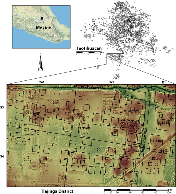
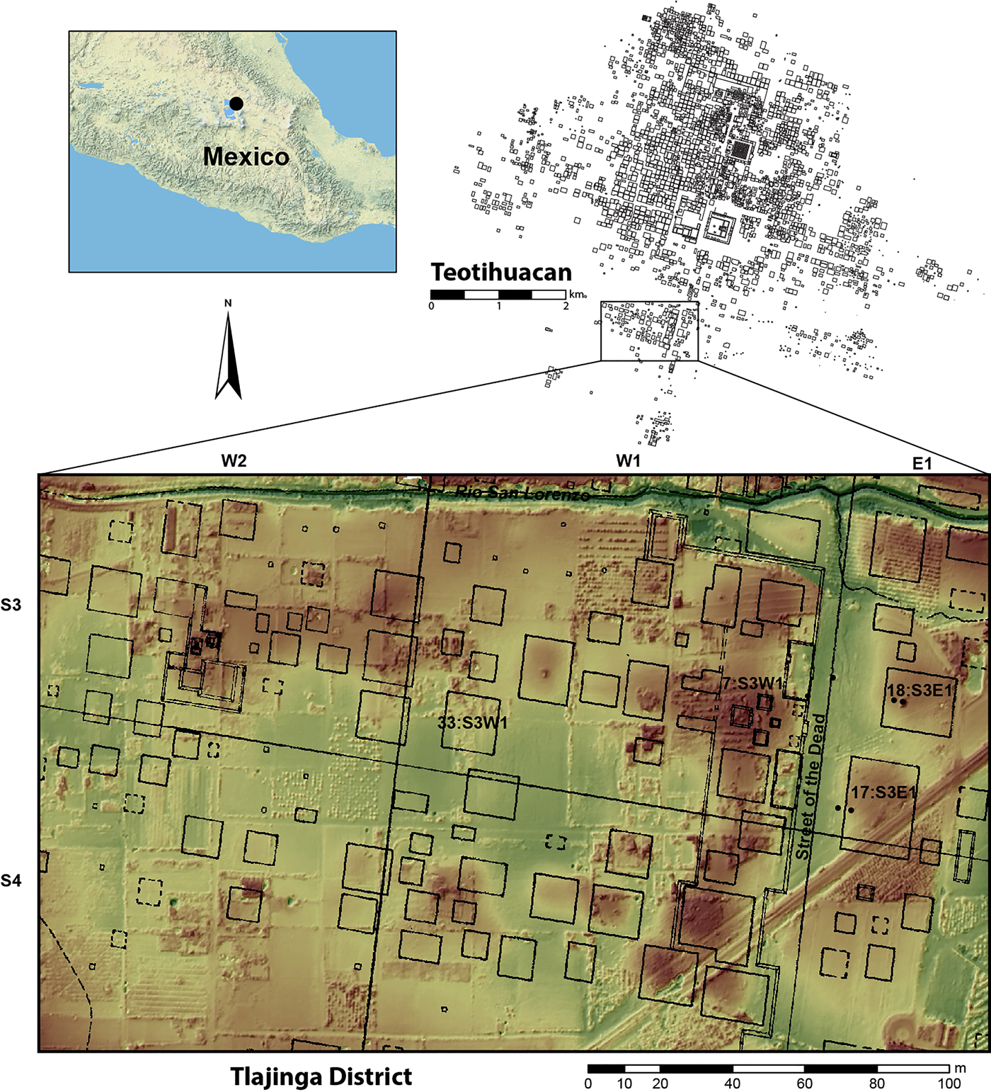
Among the urban characteristics that make Teotihuacan stand out as an early Mesoamerican city are its size and population density; its planned, orthogonal layout tethered to a central artery (the Street of the Dead); its multiethnic composition and sustained influx of migrants; the intensity and widespread distribution of craft production activities; and the housing of the vast majority of its occupants in multifamily apartment compounds—this last, seemingly unique in the ancient world. All of these themes represent focal points for renewed investigations at the Tlajinga district, a spatially discrete cluster of neighborhoods located in the city's southern periphery (Figure 1). Tlajinga covers approximately 1 km2 and was mapped by Millon and colleagues (Reference Millon, Drewitt and Cowgill1973) during the Teotihuacan Mapping Project (TMP) as containing roughly 90–100 architectural units, depending on where one defines the boundaries of the district. Most of these surface indications of structural remains exhibit the low topography consistent with buried apartment compounds, only one of which had been investigated prior to the present project—designated 33:S3W1 or “Tlajinga 33” (Storey Reference Storey1992; Widmer and Storey Reference Widmer, Storey, Santley and Hirth1993, Reference Widmer, Storey, Arnauld, Manzanilla and Smith2012). Fieldwork conducted during 2012–2015 adds excavated samples from two more apartment compounds, contexts in the center and along the eastern and western borders of the Street of the Dead, and remote sensing applied at a broader scale throughout the district. In this paper, we frame the research objectives of the Proyecto Arqueológico Tlajinga Teotihuacan (PATT) as a whole and focus particularly on reporting the major finds from the 2013–2014 excavations and the chronology of occupation.
Location of Teotihuacan's Tlajinga district and sites or excavation areas mentioned in the text, including Compounds 17 and 18 of S3E1 and excavations along the Street of the Dead (SOTD). Topographic base map produced by project with overlay of hypothetical structures following Millon et al. (Reference Millon, Drewitt and Cowgill1973).
Excavations at the two apartment compounds confirm that one of them (17:S3E1) housed obsidian workers who produced large quantities of prismatic blades, as was first proposed by Spence (Reference Spence1967, Reference Spence1981) based on surface remains collected by the TMP. The second compound (18:S3E1) revealed a stratigraphically deep sequence that provides new insights concerning the evolution of the apartment compound in this part of the city during the Late Tlamimilolpa phase (a.d. 250–350; phases follow Cowgill Reference Cowgill2015) from earlier origins in less substantial residential architecture of the late Miccaotli to Early Tlamimilolpa phases (a.d. 170–250). It also contained remains of rituals and other activities associated with central courtyards of the compound during its final occupation in the Xolalpan phase (a.d. 350–550). Artifacts from both compounds attest to a relatively high level of access to imported goods and finer items of local origin on the part of the commoner residents of Tlajinga. The location of these two compounds along the southern extension of the Street of the Dead may mean their inhabitants enjoyed somewhat greater economic means and broader social networks than those who inhabited Compound 33:S3W1. Yet, they were clearly commoners, likely to have been somewhere in the lower third of Teotihuacan's socioeconomic spectrum. Excavations along this extension of the city's central artery through the Tlajinga district provide new information regarding its construction, which was much less formal than in the center of Teotihuacan, but still represented a considerable mobilization of labor.
PROJECT OBJECTIVES AND METHODS
The PATT began with two primary sets of research objectives: (1) to excavate a domestic obsidian workshop, as defined previously by the surface work of the TMP; and (2) to investigate an area amenable to addressing broader issues of Teotihuacan urbanism, such as the tempo and processes of urbanization, the spatial and social organization of neighborhoods, and household variability in status, production, consumption, and other activities. These goals are multi-scalar in examining urban growth of the city as a whole, the spatial organization of one of its more spatially discrete districts, material remains recovered from portions of particular apartment compounds, and, in the case of obsidian, a potential export commodity that moved beyond the city through interregional exchange networks. They build especially from current understanding of the organization of districts and apartment compounds derived from larger scale and longer duration projects overseen by Cabrera, Gómez, and colleagues at La Ventilla (Cabrera Castro Reference Cabrera Castro1996; Cabrera Castro and Gómez Chávez Reference Cabrera Castro, Chávez, Mastache, Cobean, Cook and Hirth2008; Gómez Chávez Reference Gómez Chávez, Arnauld, Manzanilla and Smith2012) and by Manzanilla and colleagues at Oztoyahualco and Teopancazco (Manzanilla Reference Manzanilla1996, Reference Manzanilla, Manzanilla and Chapdelaine2009, Reference Manzanilla, Arnauld, Manzanilla and Smith2012, Reference Manzanilla2015).
After examining a few possible locations for the investigations, Carballo and Hirth concluded that the Tlajinga district possessed the best opportunity for research articulating with both sets of objectives because, in addition to the dense concentration of surface obsidian at 17:S3E1, the area has to date been less affected by contemporary urbanization of the greater Teotihuacan region, making a relatively large area available for spatial analyses. Further, previous work in the Tlajinga district offered the possibility of comparative and collaborative research. This includes the excavations undertaken at 33:S3E1 by Storey and Widmer (Storey Reference Storey1985, Reference Storey1992; Storey et al. Reference Widmer, Storey, Arnauld, Manzanilla and Smith2012; Widmer Reference Widmer, de Tapia and Rattray1987, Reference Widmer1991; Widmer and Storey Reference Widmer, Storey, Santley and Hirth1993, Reference Widmer, Storey, Arnauld, Manzanilla and Smith2012, Reference Widmer and Storey2017), investigation of canals in the area by Nichols (Reference Nichols, de Tapia and Rattray1987, Reference Nichols1988), studies of the production of San Martín Orange pottery in the center of the district by Sheehy (Reference Sheehy1992) and Sullivan (Reference Sullivan2006), and ongoing geoarchaeological and paleoethnobotanical research by McClung de Tapia and colleagues. Some of these authors report the results of their analyses in other papers of this issue.
In order to address research questions at the scale of the city, excavations were planned along the southern Street of the Dead—since this represents a city-wide axis—with the goal of identifying stratigraphically deep deposits that could recover a diachronically ordered construction sequence. For addressing issues relating to obsidian-craft production, domestic economy, and household consumption and status, excavations were planned in the area of dense surface obsidian at Compound 17:S3E1 and in the geographic center and western entrance areas of Compound 18:S3E1. The first were undertaken in 2013, the second in 2014, and excavations in areas of the Street of the Dead were undertaken in both these seasons.
For all study areas, topographic and geophysical mapping preceded excavations, allowing for a more informed understanding of spatial contexts and subsurface remains. Excavation units were typically 2 × 2 m and occasionally fractions of these dimensions. All excavated strata were screened except for vegetated topsoil, sediment samples were taken to recover botanical and microartifactual remains, and preserved floors were sampled for chemical analyses. Discrete excavation contexts, such as layers from single excavation units or contiguous strata in the adjoined units of contexts designated as features, were registered as a sequence of unique lot numbers. Artifact analyses proceeded concurrently with the excavations, some continuing to present. We detail the excavation contexts by operation area, highlighting major finds, chronological considerations, and our working hypotheses regarding urbanization at Tlajinga and various facets of domestic life for the occupants of the two compounds.
EXCAVATIONS AT COMPOUND 17:S3E1
Our designation of 17:S3E1 (Compound 17 hereafter) conflates two sites recorded and collected by the TMP, with 17-A representing a dense concentration of surface obsidian recorded as covering 60 × 50 m, and 17-B representing a collection area primarily to the east of the obsidian concentration and averaging some 150 × 120 m in extent. The original field forms from the TMP record 72 core and core fragments from 17-A and 56 of these from 17-B, both contributing to Spence's (Reference Spence1967, Reference Spence1981) designation of the area as a precinct workshop that specialized in the production of fine pressure blades from prismatic cores. The architectural reconstruction by Millon and colleagues (Reference Millon, Drewitt and Cowgill1973:115, 127) presents a single rectangular compound measuring approximately 100 meters north-south and 70 meters east-west, but cut to the southeast by the railway that directs to Mexico City through Lechería. This size estimate is consistent with the topographic rise registered by our digital mapping and remote sensing to the north and northwest of the compound, where not hindered by nopal fields, the railway, and a sizeable and occasionally pungent manure pile. Compound 17 would therefore represent the largest apartment compound in the Tlajinga district and on the upper end of the size spectrum for Teotihuacan as a whole.
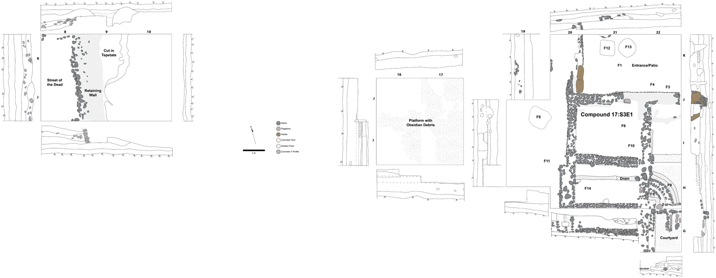
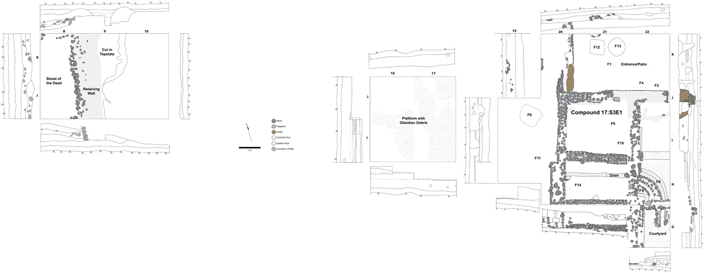
Given the large footprint of the compound, the 76 m2 of excavations (resulting in 76.8 m3 of extracted sediment) undertaken on its western side and on the external platform between Compound 17 and the Street of the Dead represent a small proportion of its total domestic space (Figure 2). These excavations nevertheless proved to be exceptionally informative regarding obsidian production activities in the area. Excavations were slowed considerably by the overwhelming density of obsidian debris, which was picked carefully from screens at a rate much slower than could be excavated. Much larger obsidian artifacts were recovered from cache deposits, where artisans appear to have either stashed their blade-cores or deposited cores, other obsidian tools, and shell, or complete vessels as part of consecration offerings to the house.
2013 excavations at the western edge of Compound 17:S3E1, platform to the west of it, and retaining wall delimiting eastern border of the Street of the Dead. Image credited to Proyecto Arqueológico Tlajinga Teotihuacan.
Architecture
The low, preserved walls exposed by excavations in Compound 17 are a mix of stone and adobe construction. Of an approximate total of 27 meters of wall, 22.5 m (83 percent) are primarily made of stone and 4.5 m (17 percent) are primarily made of adobe. Some walls preserve fragments of the smoothed clay-and-gravel amalgam that likely once covered all exposed surfaces, but has tended to crumble and wash away over time. The only place with preserved lime plaster is the lowest step of a small staircase in a courtyard only partially explored by the excavations to the southeast of the operation. Coating courtyard floors and steps with lime plaster served the practical function of water impermeability (Barba and Cordova Reference Barba Pingarrón and Frunz2010). These may have been the only places in the compound where its occupants applied such a treatment, especially since imported lime may have been harder to access than amalgams made exclusively of local materials, and would follow a pattern documented at 33:S3E1 (Widmer and Storey Reference Widmer and Storey2017).
Rain water was also carried away from this courtyard by a drain with its mouth in the northwest corner and a course that begins draining northward before taking a bend to the west to empty at the exterior wall of the compound. Two superimposed concrete floors extend a little under one meter north of the bend in the drain, but the excavated floors of the three adjacent rooms were of packed earth. There was also no formal floor in the patio or possible entranceway to the north of the excavation, where features were cut into the earthen living surface directly above tepetate (the volcanic tuft substrate).
To the west of the compound is an open platform with two to three superimposed earthen floor levels from which the densest concentrations of obsidian were recovered. Obsidian was dense in all contexts associated with Compound 17, with a total of over 400 kg of debitage originating from these small-scale excavations, and even more found as cached artifacts. The auguring program by Hirth and colleagues (Reference Hirth, Carballo, Dennison, Carr, Imfeld and Dyrdahl2019) and the embedded obsidian microdebitage found in the floor micromorphological samples studied by Stahlschmidt and colleagues (Reference Stahlschmidt, McClung de Tapia and Gutiérrez-Castorena2019) make the platform the likely location of most of the production activities. The space would have been ample, as the west platform measures approximately 25 meters east-west between the exterior wall of the compound and a retaining wall delimiting the eastern border of the Street of the Dead. Its north-south dimension remains unknown, but it may have abutted much of the 100 m of the compound.
Features and Materials
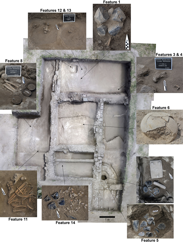
In addition to the abundance of obsidian debris encountered during excavations at Compound 17, the occupants did a service to understanding prismatic blade technology at Teotihuacan by caching a number of cores, which range in the reduction sequence from percussion macrocores to exhausted pressure cores (Figure 3). One of these deposits (Feature 1) has characteristics more suggestive of a cache for later use, including its location in the northern patio or entranceway, lack of associated with formal floors or architecture, and content of 10 cores ready for pressure reduction. Nevertheless, fragments of human bone lay under the cores, which may be more consistent with an offering context. A close-to-exhausted pressure core was also deposited nearby (Feature 4).
Larger excavation block at Compound 17:S3E1, with locations of select features. Photographs by Carballo.
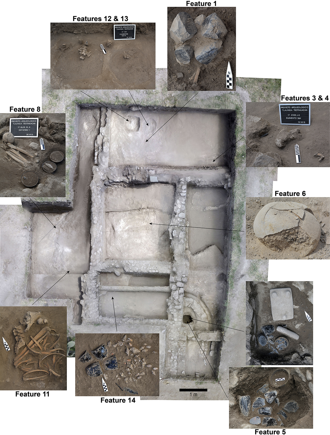
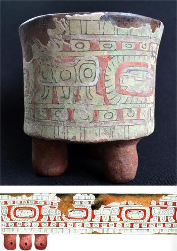
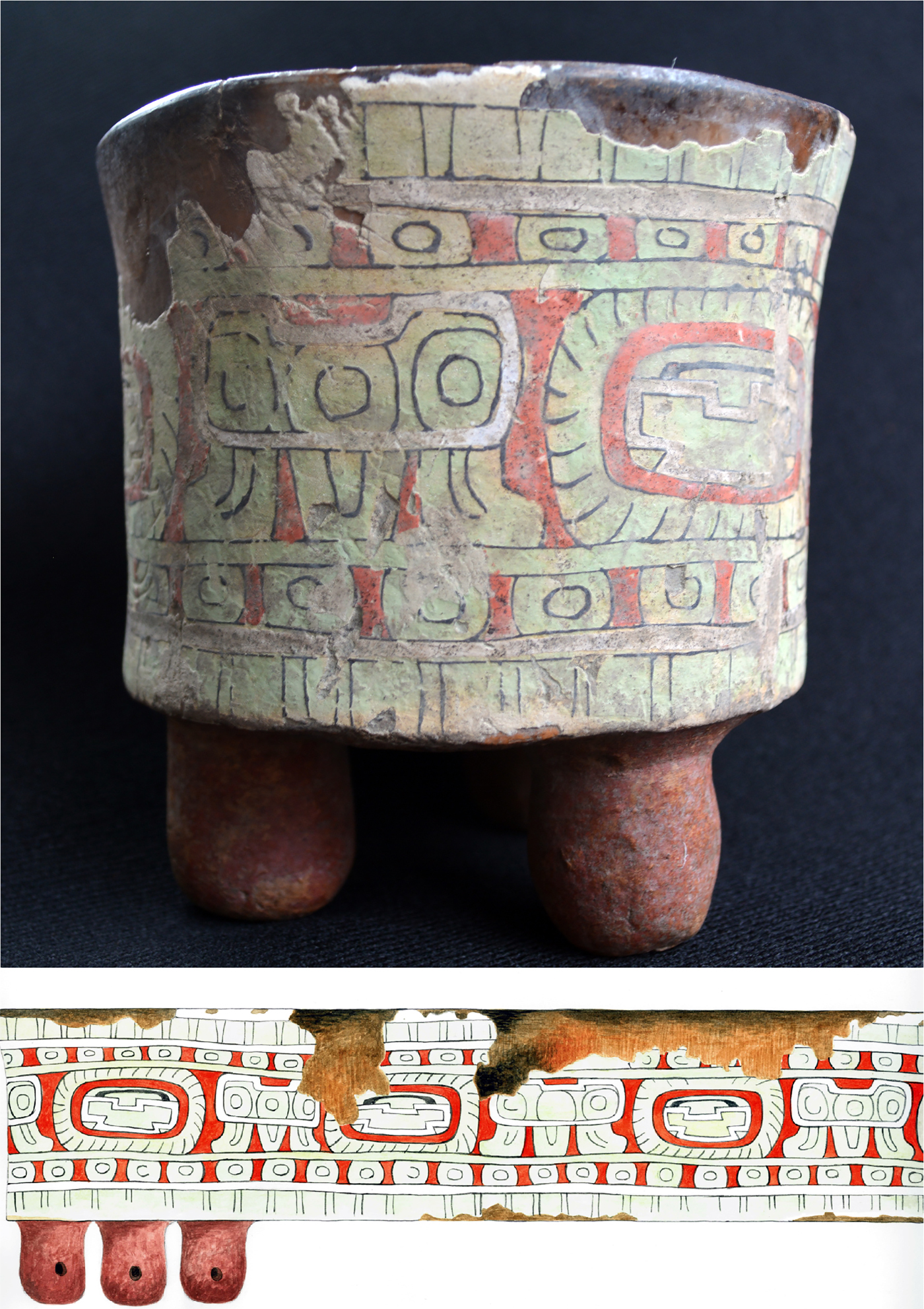
Two other cache deposits appear much more consistent with having been purposeful offerings. Feature 5 is the most complex of these and was located in a cyst within the bend in the drain covered by a small, inverted metate. Inside the cyst were a stucco-painted tripod vessel, a second ceramic vessel, and an abundance of obsidian products including 19 blade-cores, 72 dart points, and two knives. The stucco-painted vessel is decorated with motifs of nose plugs, worn by deities or elite personages in the art of Teotihuacan, set between two parallel bands of jade bead motifs, symbolically indexing preciosity (Figure 4). The vessel exhibits an ancient repair of the stucco, suggesting that this was a finer piece that its owners treated with special care. Feature 14 contained four obsidian cores and 100 complete gastropod shells with five other shell fragments. It was located on top of tepetate, 40 cm below where the drain continued west before exiting the compound. The general association with the drain feature and the fact that none of the complete gastropods exhibited evidence of modification—whereas approximately half of the isolated shell artifacts excavated from Compound 17 do—may indicate that the deposit was made more symbolically, alluding to aquatic themes, rather than as a cache for later use. Irrespective of its symbolism, the deposit demonstrates the inhabitants of the compound had access to marine resources from the Gulf and Pacific coasts. The Gulf species represent 45 percent of the offering and are almost exclusively conches (e.g., Triplofusus giganteus, Latirus cariniferus, Strombus granulatus), except for a single sea snail, whereas the Pacific species represent 55 percent of the offering and are exclusively olive shells (Oliva spp.), except for the five fragmentary pieces of jewel box clam (Chama echinata). Offerings of shell and tripods have been previously found in association with drains, particularly in bends in such drains, elsewhere at Teotihuacan including at the Quetzalpapalotl Palace and the drain under the Street of the Dead near the Ciudadela (Acosta Reference Acosta1964; Monzón Flores Reference Monzón Flores and Castro1982).
Stucco-painted tripod vessel from Feature 5 of Compound 17:S3E1. A pre-Hispanic repair is visible to the right of the vessel in the photograph. Roll-out illustration depicts six nose adornments as central motifs. Photograph by Carballo, illustration by Pedro Cahuantzi Hernández.
Features containing human remains were found exclusively in the northern patio/entranceway and on the platform just west of the compound. In the first context (Features 3, 12, and 13) remains were completely disarticulated and left in piles above two low depressions in the tepetate. The second, Feature 11, consisted of a partially articulated torso that was encountered above tepetate with the remains of a Tlamimilolpa-phase bowl and a figurine. Feature 8 is a post-Teotihuacan, intrusive burial of a flexed individual interred with five Mazapan-phase vessels. Both figure in the chronological considerations discussed later.
EXCAVATIONS AT COMPOUND 18:S3E1
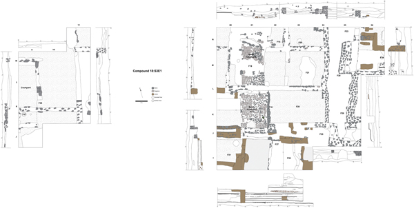
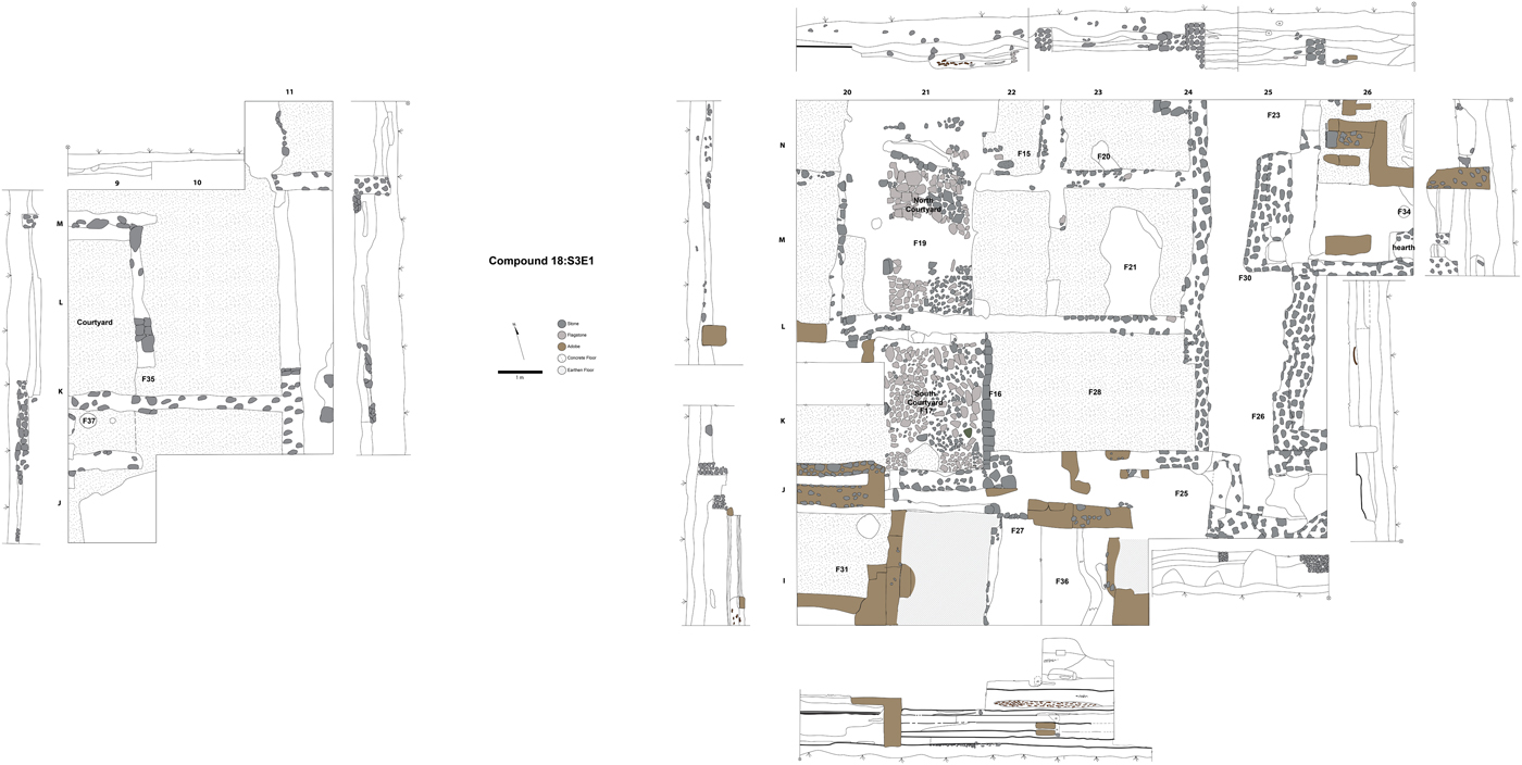
Compound 18 is located to the north of Compound 17 and is somewhat smaller, with its discernable rise in topography spanning approximately 60 meters on a side. The TMP designated the collection area as 134 × 100 m and our complete coverage with magnetometer suggests more accurate dimensions for the footprint of the compound as 60 m east-west and between 70 to 100 meters north-south, with a large quadrangular addition on the south creating an asymmetrical outline. Excavations at the compound proceeded in two horizontal blocks: a larger one (144 m2) in the center of the compound and a smaller one (44 m2) near its western entrance, opening to the Street of the Dead but offset from the thoroughfare itself (Figure 5). These excavations were not hindered by the slower artifact recovery from the dense obsidian at Compound 17 and a total of 129.8 m3 of sediment was excavated at Compound 18. The center of the compound also possesses deeper deposition, allowing us to descend up to 2.65 m below surface in the southern and western portions of the larger excavation block—areas that did not have stone walls—and register a complete occupation sequence with up to eight discernable floor levels.
2014 excavations at Compound 18:S3E1. Image credited to Proyecto Arqueológico Tlajinga Teotihuacan.
Architecture
The larger excavation block at Compound 18 uncovered the central portion of the apartment compound, including two stone-floored courtyards and parts or all of eight rooms and two porticos arranged around them. As at Compound 17, construction materials include a mix of masonry and adobe with little lime plaster, found only in association with a small staircase in the eastern end of the larger exposure. The proportions of adobe to stone are virtually identical, as well. Combining the two exposures from Compound 18, approximately 71 meters of registered walls were roughly 59 meters stone (also 83 percent) and 12 meters adobe. Only considering the larger exposure, the percentage of stone drops slightly to 42 of 54 m (or 78 percent), but these excavations were deeper and uncovered earlier walls in areas away from the central courtyard that were made from adobe. These patterns support two observations made by Widmer (Reference Widmer, de Tapia and Rattray1987) of Compound 33:S3W1: that the ratio of stone to adobe increases during the final (Xolalpan- and Metepec-phase) occupation, and that courtyard areas exhibit the greatest architectural elaboration. A rough calculation of stone to adobe at Tlajinga 33 suggests similar proportions to Compounds 17 and 18, with 200 m of some 242 m of wall being stone (also 83 percent), and the stone-floored courtyards of 18:S3E1 and 33:S3W1 are stylistically very similar.
A wall with a drain opening at its base separates the two courtyards of Compound 18 and allowed water to pass from the southern courtyard to the northern one. This wall overlays all other construction in the central compound and may have been the last to be built, suggesting that the two courtyards may have been conjoined in an earlier phase but were later subdivided. The two rooms, or low platforms, on the east sides of both courtyards were the most substantial we encountered—the northern one having collapsed remains of a pillared portico with cut stone and the southern one having nicely hewn blocks still in situ, serving as a step down to the courtyard. The greater architectural elaboration using stone and stucco in courtyards probably relates to their having served as loci for group activities and in having been unroofed. Gatherings would have necessarily been small, however, because the courtyards are of modest proportions. Their total areas are 8.8 m2 for the northern courtyard and 6.5 m2 for the southern one, a total of 17 m2 without the subdividing wall. This is smaller than the 19 m2 registered for the similar stone-floored courtyard documented by Widmer (Reference Widmer, de Tapia and Rattray1987:337) at 33:S3W1, which was itself a later-phase reduction of an original 64 m2 courtyard from the Early Tlamilimolpa phase. It is possible that Compound 18 also once had a larger courtyard than it did in its final occupation phases, but we did not encounter remains of one in the deeper units and did not dismantle the architecture of the central compound to investigate below. As a point of comparison, late-phase central courtyards or patios of elaborate apartment compounds in the center of the city such as Tetitla, Yayahuala, and Zacuala encompass approximately 100 m2 or more, many times larger than those documented thus far at Tlajinga.
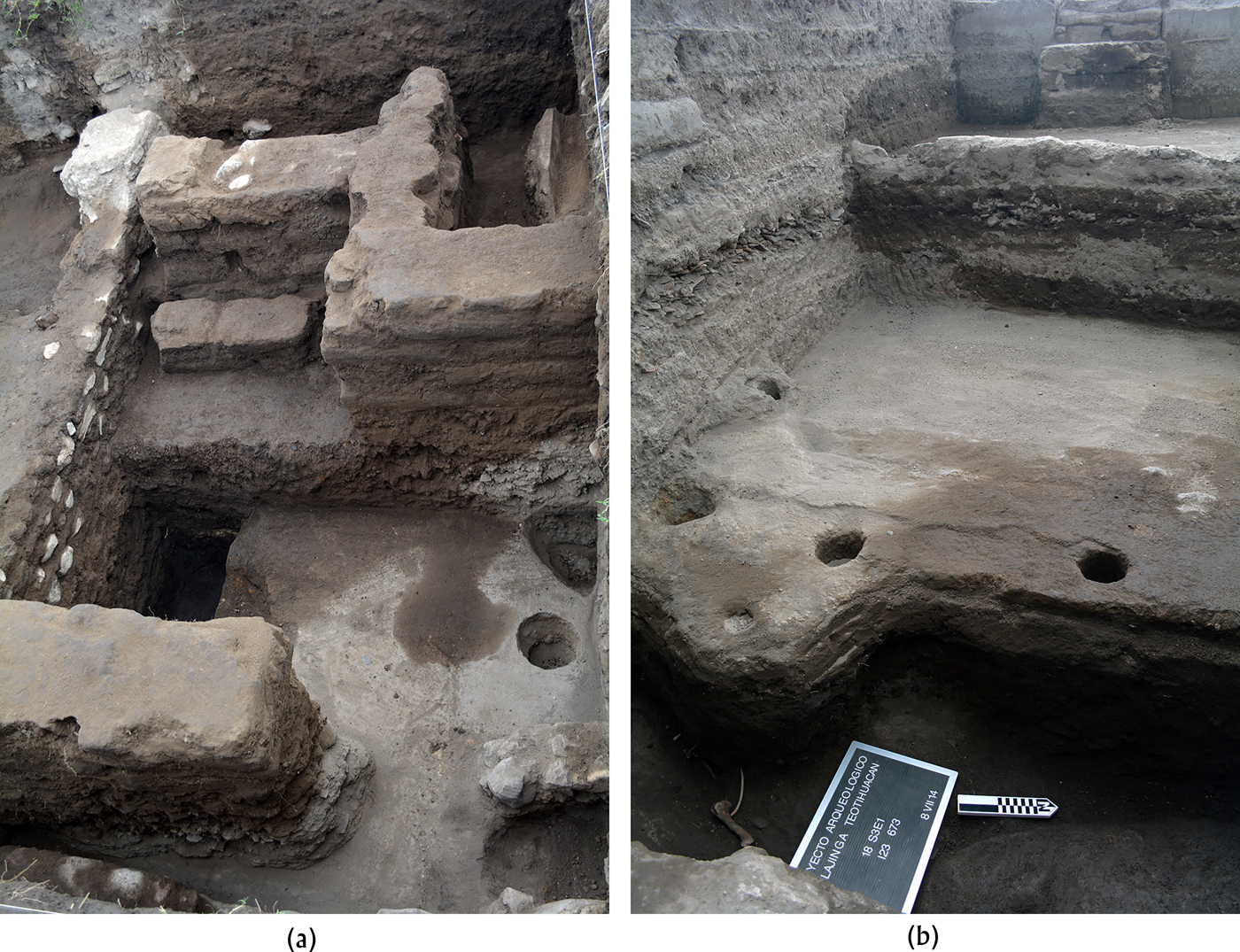
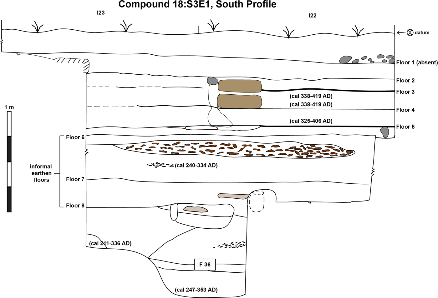
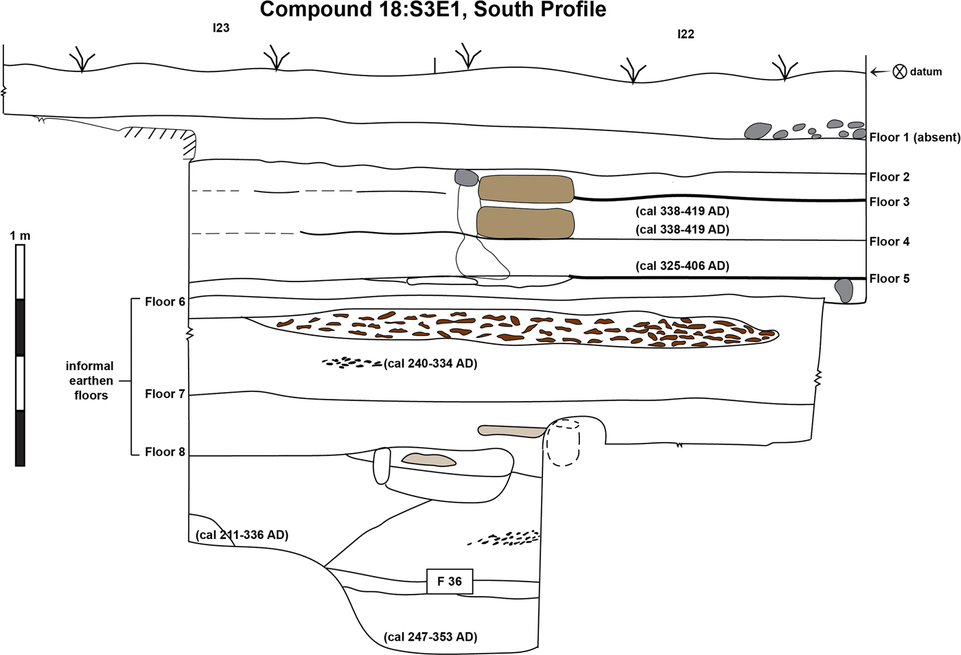
Floors of the rooms ringing the courtyards were made of concrete with no or very little stucco coating. Away from the courtyards and in lower stratigraphic levels, earthen floors and adobe walls were relatively more common. In the deep excavation to the south, only two of the eight registered floor levels (Floors 1–8) were made of concrete amalgam; yet three of the four floor levels (Floors 2–5) in the deep excavation to the east were of this construction. Here, substantial adobe walls consistent with the orthogonal rooms of apartment compounds begin above Floor 3, which appears at the same stratigraphic level as Floor 5 in the sequence to the south—also underlying adobe walls (Figure 6a). It should be noted that, although they involved lower labor inputs than did cut stone, the thermal properties of adobe walls likely made the material attractive for living and sleeping quarters, as they keep rooms warmer in winter and cooler in summer than does stone.
Deep excavations to (a) east and (b) south of the large excavation at Compound 18:S3E1, showing early features such as hearths, postholes in informal floors, and adobe walls. Photographs by Carballo.
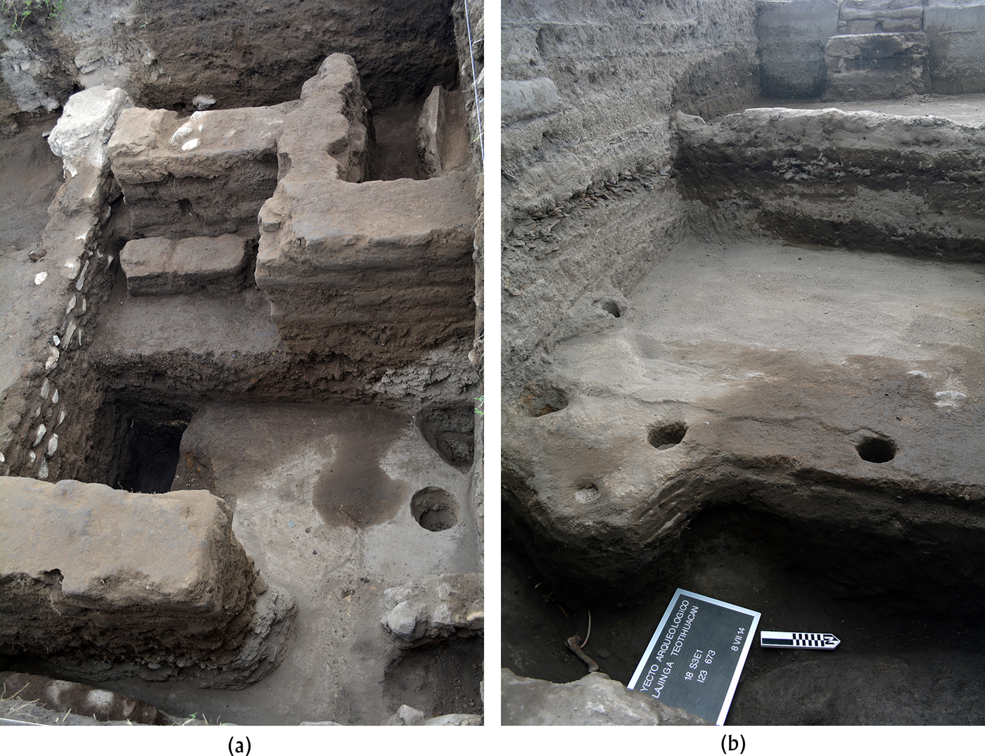
In addition to more adobe construction, the deep excavations to the east and south of the large exposure uncovered hearths in both areas—in stark contrast to higher construction layers in Compound 18 or anywhere in Compound 17, where none were registered. The lowest floor level registered in the southern area (Floor 8) was also distinct from all others, being made of crushed tepetate, clay, and sand, and featuring six postholes defining a wall line running north-south on the Teotihuacan grid orientation. East of the postholes was a hearth with evidence of in situ burning (Stahlschmidt et al. Reference Stahlschmidt, McClung de Tapia and Gutiérrez-Castorena2019), under which was a pit feature partially excavated into tepetate (Figure 6b). These two occupation surfaces appear at the same general elevation, between 1.6–1.8 meters below surface. The construction techniques and the presence of hearths at this level suggest domestic areas that preceded the construction of apartment compounds. It is important to note, however, that the two areas of deep excavations comprise only approximately 10 square meters. These early structural remains and features could therefore also correspond to out-structures or kitchens, and remains of apartment compounds from this level could appear elsewhere. Whatever the case may be, this earlier construction appears to have been oriented to the city-wide grid system.
Features and Materials
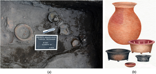
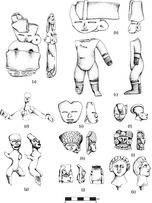
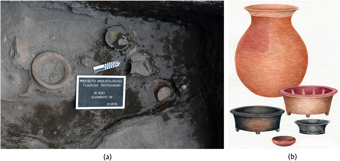
Under both hearths, at depths over two meters below surface, the early occupation layers also included sealed features and deposits of artifacts. Feature 34 consists of two small, shallow pits in the concrete of Floor 4. The southern one could be the base of a shallow posthole, or a small cache dug to inter a single, small conch shell. The northern one was only partially excavated and contained two exhausted obsidian cores. More informative is Feature 36, the pit feature below the hearth in the southern profile, as it contained complete and semi-complete vessels and figurines, consistent with an early midden deposit (Figure 7). At the other end of the chronological spectrum was Feature 23, a pit located near the surface in the northeast of the large exposure. It contained Aztec III/IV-phase materials, including what appears to be an early Colonial figurine head (Figure 14k) and a bronze needle. As with the Mazapan-phase burial from Compound 17, this feature demonstrates continued but periodic rural settlement following Teotihuacan's Classic-period collapse.
(a) Feature 36, excavated in tepetate at the lowest level of Operation 18 with (b) reconstruction drawing of recovered ceramics. Photograph by Carballo, illustration by Pedro Cahuantzi Hernández.
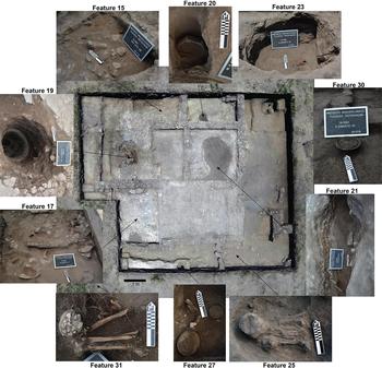
Burials were concentrated in the areas south and east of the courtyards at stratigraphic levels that all have floor levels or wall remains consistent with apartment compound construction (Figure 8). Feature 25 and Feature 31 are flexed burials with heads oriented west; Feature 27 contained the remains of a neonate placed in a small dish with the partial remains of a second individual placed in a nearby bowl; and Feature 30 is a neonate burial placed in a bowl (see Storey Reference Storey, Buckley and Kennett2019). Two pit deposits represent looted features located in the center of the northern courtyard (Feature 19) and the center of the room off of this courtyard (Feature 21). The first contained several large fragments of a composite censer, and the second contained partial human long bones. These indicate that, during or soon after the abandonment of the compound, individuals excavated in these centrally located areas to remove items from offerings or burials.
Larger excavation at Compound 18:S3E1, with location of select features from higher stratigraphic levels. Aerial photo was taken prior to the excavation of units containing Features 21 and 31, so arrows point to surface indications. Photographs by Carballo.
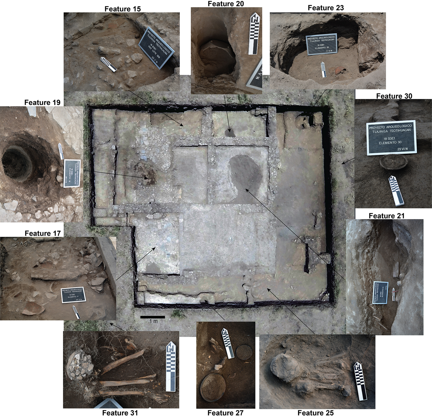
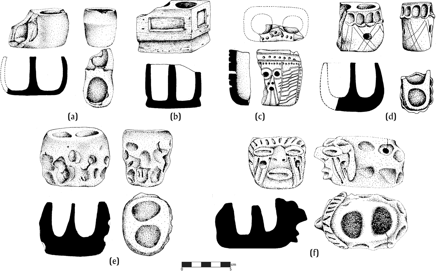
Chronologically late deposits corresponding to the primary occupation, and discovered in situ, include a deposit of 10 two-chambered candeleros in the room or portico northeast of the northern courtyard (Feature 15) and a dense concentration of materials recovered from the floor of the southern courtyard (Feature 17) and the step from it to the room on its eastern side (Feature 16). The function of candeleros at Teotihuacan has still not been definitively demonstrated, but it is often assumed they were used for burning incense such as copal during rituals (Kolb Reference Kolb and Kolb1988). Other potential items of ritual use in deposits surrounding the courtyards include large fragments of two turtle carapaces and one plastron, which may have served as parts of drum-rattles when complete.
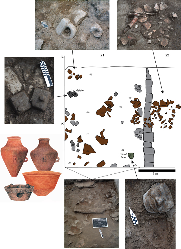
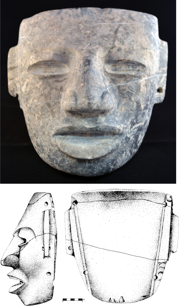
Feature 17, the southern courtyard floor deposit, is of greatest interest because it included a complete stone face, or “mask,” deposited face-down. Representing one of the few of these iconic faces to be discovered by controlled excavations in situ (see Rose and Walsh Reference Rose and Walsh2018), it is worth reviewing its context in detail. It was part of the larger deposit containing smashed ceramic vessels from this feature and Feature 16, and domestic tools such as a smoother made of fine basalt, a mano, and a complete metate that was broken in half (Figure 9). The complete condition of many of the tools and ceramic vessels (of Late Xolalpan or Metepec phases) and their purposeful breakage on the courtyard floor are all consistent with having been part of a termination ritual that included leaving the stone face as part of the offering. The face-down orientation may have been of symbolic significance, also indexing termination of the compound and, perhaps, the individual or lineage that the face personified. As a parallel example, in one of the most elaborate cache deposits discovered at 33:S3W1, Widmer (Reference Widmer, de Tapia and Rattray1987:363) notes that a large clay “host” figure was interred face-down. The Compound 18 face is made of limestone and has perforations at its back corners (Figure 10). Its weight (3.5 kg) and the perforations would have made it more suitable to lashing to a post or effigy body rather than on mortuary remains, which were completely absent in the deposit. The archaeological context is therefore most consistent with use in or near the courtyard, in effigy to an individual or group of importance to the compound inhabitants, and a termination that necessitated its purposeful leaving behind when the compound was abandoned—with no evidence of associated looting in the southern courtyard, as was found in the northern courtyard.
Detail of Feature 16/17 from Compound 18:S3E1 with in-situ deposits of broken ceramics, metate, other tools, and the stone face. Photographs by Carballo, illustrations by Pedro Cahuantzi Hernández and Proyecto Arqueológico Tlajinga Teotihuacan.

The stone face effigy from Feature 17 of Compound 18:S3E1. Photograph by Carballo, drawing by Pedro Cahuantzi Hernández.

EXCAVATIONS ALONG THE SOUTHERN STREET OF THE DEAD
Excavations along the southern extension of the Street of the Dead were undertaken concurrently with the Compound 17 and 18 excavations in 2013 and 2014. These were more extensive in the second season, when a total of 34 m2 (49 m3) were excavated primarily in the midpoint of avenue in order to reveal a stratigraphic sequence over two meters deep. It is readily apparent from visual inspection of the topography at the site or in satellite imagery (Blancas et al. Reference Blancas, Barba, Ortiz, Acosta, Mejía and Carballo2019) that the southern extension of the Street of the Dead running through Tlajinga is lower than the surrounding topography. The extension of the city's central artery into areas 3 km south of the city was first postulated by Paddock (cited in Millon Reference Millon1973:38), who noted that thin soils on the southern urban fringe may suggest the extension was excavated into tepetate. Millon agreed with this assessment and proposed a quadripartite division of the city with the Street of the Dead and narrower East and West Avenues serving as major partitions, with the entire 5 km, or greater, extent of the Street of the Dead possessing strong ritual functions (see also Cowgill Reference Cowgill2000; Evans Reference Evans2016). Noting the less-elaborate construction and irregular placement of structures south of the Ciudadela and Great Compound, Sugiyama (Reference Sugiyama1993:110) perceives a strong break in the function and meaning of the Street of the Dead south of the urban epicenter. He also questions the model of quadripartite urban partitioning and the presence of an East-West Avenue, and views the southern Street of the Dead in more utilitarian, less-ritual terms.
Project excavations are the first to evaluate the above propositions, and they confirm Paddock's proposal of a substantial modification of tepetate in order to continue this central axis southward, perfectly oriented with the central staircase of the Moon Pyramid (Figure 11). Yet the excavations also uncovered remains of much simpler construction than is found in the urban epicenter such as the retaining wall dividing the west platform of Compound 17 and the cut tepetate. Further, the offset positioning of Compound 18, away from the eastern edge of the avenue, is suggestive of more relaxed urban planning, consistent with Sugiyama's characterization of it as a utilitarian thoroughfare and possible conduit of water to the San Lorenzo River during the rainy season. Mejía Ramón's (Reference Mejía Ramón2016:141–146) topographic data for the Street of the Dead south of Tlajinga is further consistent with this hydraulic association, suggesting that the cut comprising the Street of the Dead continues for approximately one kilometer farther south until it connects with the Barranca del Patlachique.
Composite of profiles depicting cut tepetate for southern Street of the Dead running through the Tlajinga district. Note that trenches were not excavated along the same east-west axis and are offset by the values listed between them. Image credited to Proyecto Arqueológico Tlajinga Teotihuacan.

As a project of urban development, the dimensions of the cut in tepetate registered for the portion of the southern Street of the Dead running through the Tlajinga district are consistent with a significant mobilization of labor. Combining dimensions for the width and depth of the cut from excavations with the values registered elsewhere in the district using ground-penetrating radar, approximately some 17,200 cubic meters (approximate dimensions: L = 430 meters, W = 40 meters, D = 1 meter) of tepetate was excavated for the swath running south through the district from the San Lorenzo River. For comparison, the tunnel underneath the Sun Pyramid is a fraction of this at approximately 263 m3. If our projected dimensions are accurate, just this section, of under one-half kilometer, would represent some 11,467–19,111 labor days spent excavating tepetate (0.9–1.5 m3/day, following estimates by Murakami [Reference Murakami2015] and Barba Pingarrón and Cordova Frunz [Reference Barba Pingarrón and Frunz2010], respectively). Such a project could have been met over two to four months—a dry season—if the crew numbered between 200–300 workers. It would represent a large-scale labor project, but still one that could have been organized and undertaken at the level of the district itself, whose resident population at its height may have been ten times this figure. If the cut tepetate extends another kilometer to the south, as we estimate, these projections would need to be doubled or tripled.
CHRONOLOGICAL CONSIDERATIONS
A chronology of occupation for Compounds 17 and 18 combines the 29 AMS radiocarbon assays currently analyzed by the project with architectural and artifactural benchmarks, such as the superimposed sequence of walls and floors at Compound 18 and secure middens and offerings in both compounds. Radiocarbon (14C) analyses were overseen by Kennett and Buckley at the Penn State Human Paleoecology Isotope Geochemistry Lab. Charcoal and organic materials were processed for 14C dating using an acid-base-acid procedure as described in Kennett et al. (Reference Kennett, Plog, George, Culleton, Watson, Skoglund, Rohland, Mallick, Stewardson, Kistler, LeBlanc, Whiteley, Reich and Perry2017) with slight modifications. After removing adhering sediment, approximately 20 milligrams of each sample were subjected to alternating acid-base-acid washes in 1N HCL and 1N NaOH at 70°C for 20 minutes each. The initial acid wash dissolved any carbonate contamination. The repeated base washes extracted humates accumulated from soil organic matter. A final acid wash removed secondary carbonates formed during the base treatment. After this procedure, samples were returned to neutral pH with two 20-minute baths in deionized (DI) water at 70°C to remove chlorides. The samples were then dried.
For human skeletal remains, bone samples (1,000 mg) were demineralized for 48–72 hours in 0.5 N HCl at 5°C, then neutralized through multiple rinses of DI water. Following the revised Longin method (Brown et al. Reference Brown, Nelson, Vogel and Southon1988), the remaining collagen was gelatinized in 1–2 milliters of 0.01 N HCl at 60°C for 10 hours and lyophilized for 24–48 hours. Samples were then weighed and, based on the total yield, individual samples were then either run through the ultrafiltration process (see Brown et al. Reference Brown, Nelson, Vogel and Southon1988; Kennett et al. Reference Kennett, Plog, George, Culleton, Watson, Skoglund, Rohland, Mallick, Stewardson, Kistler, LeBlanc, Whiteley, Reich and Perry2017) or through XAD-2 resin (styrene-divinylbenzene) chromatography (Lohse et al. Reference Lohse, Madsen, Culleton and Kennett2014; Stafford et al. Reference Stafford, Brendel and Duhamel1988, Reference Stafford, Hare, Currie, Jull and Donahue1991). For more detail concerning this methodology, see the article by Storey and colleagues in this issue.
For quality control, carbon and nitrogen concentrations and stable isotope ratios were first measured at the Yale Analytical and Stable Isotope Center with a Costech elemental analyzer (ECS 4010) and Thermo DeltaPlus analyzer. Sample quality was evaluated by % crude gelatin yield, %C, %N, and C:N ratios before AMS 14C dating. C:N ratios for all samples fell between 3.0–3.4, indicating good collagen preservation (van Klinken Reference van Klinken1999). Samples were combusted for 3 hours at 900°C in vacuum-sealed quartz tubes with CuO powder and Ag wire to produce sample CO2. This was then sent to W.M. Keck Carbon Cycle Accelerator Mass Spectrometer (KCCAMS, University of California-Irvine), where it was reduced to graphite at 550°C using a H2 and Fe catalyst, with reaction water drawn off with C-9 Mg(ClO4)2 (Santos et al. Reference Santos, Southon, Druffel-Rodriguez, Griffin and Mazon2004). Graphite samples were pressed into targets in A1 cathodes and loaded on a target wheel with standards and backgrounds for AMS analysis. Dates were then calibrated with OxCal v.4.2.4 (Bronk Ramsey Reference Bronk Ramsey2013) using the IntCal13 Northern Hemisphere curve (Reimer et al. Reference Reimer, Bard, Bayliss, Buck, Blackwell, Ramsey, Buck, Cheng, Edwards, Friedrich, Grootes, Guilderson, Haflidason, Hajdas, Hatté, Heaton, Hoffman, Hogg, Hughen, Kaiser, Kromer, Manning, Niu, Reimer, Richards, Scott, Southon, Staff, Turney and van der Plicht2013).
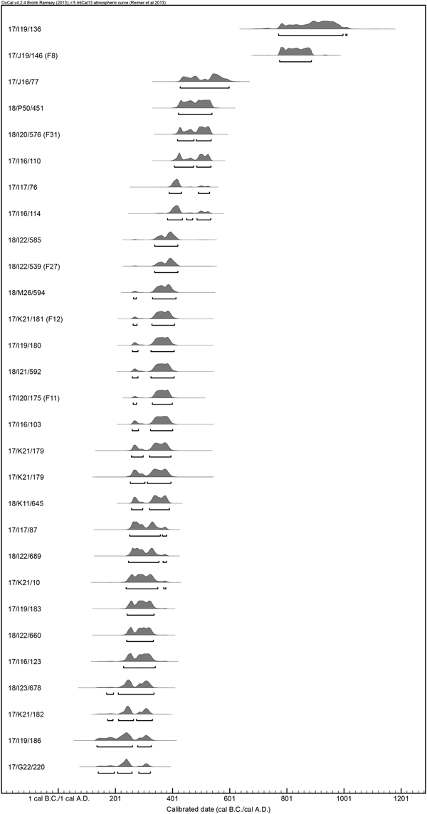
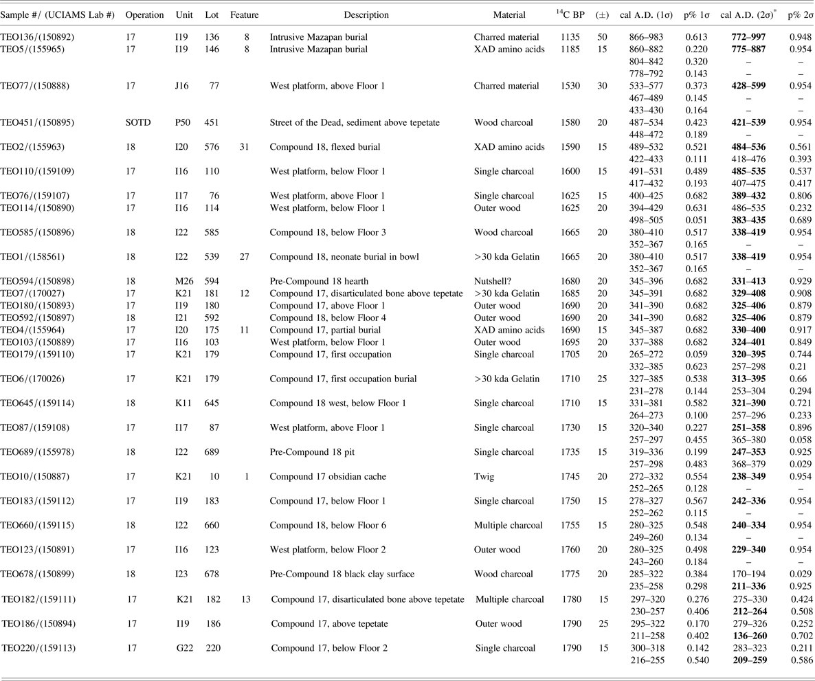
The resulting radiocarbon dates are presented in Table 1 and Figures 12 and 13. Apart from the intrusive Mazapan burial, two-sigma ranges on the Classic-period occupation span cal a.d. 136–599. Taken together, the earliest few dates show clear initial occupation in the early third century, whereas the latest few dates span the late fifth to early sixth centuries, consistent with mounting support for the city's collapse ca. a.d. 550 (Manzanilla Reference Manzanilla2015). In the revised chronology presented by Cowgill (Reference Cowgill2015:Table 1.2), occupation of the eastern part of the Tlajinga district would span the Early and Late Tlamilimolpa and the Early and Late Xolalpan phases.
Distribution of radiocarbon dates from project excavations in 2013–2014, following Table 1. Sample identification numbers (IDs) follow format of operation/unit/lot with features in parentheses, if applicable. Image credited to Proyecto Arqueológico Tlajinga Teotihuacan.

Profile illustration from southern wall of large exposure in Operation 18, showing superimposed floor levels, associated radiocarbon assays, and location of Feature 36. Image credited to Proyecto Arqueológico Tlajinga Teotihuacan.
Radiocarbon dates listed in reverse chronological order.

* Calibrated date ranges with the highest p-values are listed in bold.
Artifact analyses are still ongoing, but diagnostic ceramic vessels and figurines are generally consistent with this phasing, except for the presence of slightly earlier (Miccaotli-phase) and slightly later (Metepec-phase) attributes. Feature 36 and Feature 16/17 nicely bookend the Classic-period occupation with relatively intact vessels and figurines. Early elements, following Rattray (Reference Rattray2001), in the ceramics from Feature 35 include red-on-natural surface treatment and a small shouldered bowl; late elements include nubbin supports on polished monochrome bowls and incising on an outcurving bowl (Figure 7). Figurines from the same feature exhibit early characteristics in their manufacture without the use of molds, relative size, and headdress elements (Figures 14a–14c). This combination of attributes is consistent with a deposit transitional between the Miccaotli and Early Tlamimilolpa phases, dating the possible pre-compound construction layers to the latter phase by association. The termination deposit represented by Feature 16/17 contains three large and mostly complete vessels of San Martín Orange ware: two amphorae and a crater with pocked base (Figure 9). The other semi-complete vessel from this context is a course, matte, three-pronged burner with mold-applique depictions of flowers. Candeleros are also diagnostically late, especially those with thumbnail indentations, which were found in this feature, Feature 15, and other upper stratigraphic deposits (Figures 15e and 15f). The combined attributes suggest a Late Xolalpan to Metepec abandonment, with nothing that compellingly tilts the balance for occupation in the latter phase, such as the presence of mold-pressed wares diagnostic of the Metepec phase. These early and late attributes from secure contexts at the lowest and highest stratigraphic levels of Operation 18 suggest to us that either the area was occupied and abandoned during transitional periods (Miccaotli/Early Tlamimilolpa and Late Xolalpan/Metepec, respectively) or the ceramic sequence for Teotihuacan requires compression on both ends.
Figurines from Compounds 17 and 18 of S3E1: (a–c) from Feature 36; (d–i) in approximate chronological order; (j) non-local style, perhaps from west Mexico; (k) Colonial period, from Feature 23. Drawings by Pedro Cahuantzi Hernández.

(a–f) Candeleros from Compounds 17 and 18 of S3E1. Drawings by Pedro Cahuantzi Hernández.

Complete and semi-complete vessels from stratigraphically intermediate deposits thus far appear to fit comfortably within the Tlamimilolpa and Xolalpan phases. This includes the stucco-painted tripod from Feature 5, whose rounded rather than slab feet suggest an Early Xolalpan-phase manufacture, though the patched stucco may indicate deposition later in this phase (Figure 4). Although we encountered deeper deposits in Operation 18 than in Operation 17, the latter produced earlier radiocarbon dates. A date from the black clay layer that McClung (Reference McClung de Tapia2015) has demonstrated to be the early occupation surface at Teotihuacan, and into which Feature 36 was excavated, is surprisingly late (a.d. 211–336); yet Stahlschmidt et al. (Reference Stahlschmidt, McClung de Tapia and Gutiérrez-Castorena2019) note the heavy anthropogenic modification of the clay layer in this area, meaning later materials could have been redeposited. Taken together, there is nothing to indicate apartment compound construction in the Miccaotli phase, but it is certainly present by the Late Tlamimilolpa phase, demonstrated by multiple dates above Floor 5 in the sequence to the south of the large excavation at Compound 18 (Figure 13) or the stratigraphically similar Floor 3 to the east. Earlier dates from Compound 17, such as for Features 1 and 13, suggest that apartment compounds began to be constructed at some point during the Early Tlamimilolpa phase, consistent with the sequence from 33:S3W1. The only date yet analyzed from the Street of the Dead is late (a.d. 421–539), but it originated from a non-secure sediment layer above tepetate, which may indicate that the avenue was kept as exposed tepetate (likely necessitating periodic cleaning) before having been infilled through fluvial action following abandonment (see Stahlschmidt et al. Reference Stahlschmidt, McClung de Tapia and Gutiérrez-Castorena2019).
DISCUSSION
New excavations at the Tlajinga district provide additional insights concerning Teotihuacan and also generate new lines of inquiry, several of which are pursued in the remaining papers of this special section. Archaeological contexts, including architectural elements and artifact deposits, provide information at varied scales from the important interregional export commodity of obsidian to processes of urbanization and patterns of daily life. We end with a few preliminary observations regarding domestic economy at Tlajinga and the tempo and processes of urban sprawl on Teotihuacan's southern periphery.
Viewed synchronically, the excavations provide a better appreciation for the role of utilitarian-craft producers, particularly the obsidian workers who resided at Compound 17, and broader participation on the part of commoners at Teotihuacan in an interregional economy. Discoveries such as cached marine shell and the stucco-painted tripod from Compound 17, or the stone face from Compound 18, attest to a remarkable degree of access to imported or value-added commodities on the part of individuals who, by their peripheral location in the city and the relatively simplicity of their urban apartments, can be considered as commoners representative of a lower stratum in Teotihuacan's socioeconomic spectrum. A goal of future analyses is to bring better temporal and societal resolution to this understanding of quotidian life in this part of the city. We cannot yet say whether status, access to resources, or production activities varied significantly over time and, if so, in what ways. For instance, did major craft activities associated with Compounds 17 and 18 change through their centuries of occupation and may this have been associated with changes in status or relative purchasing power, as Storey et al. (Reference Storey, Márquez-Morfín, Núñez, Arnauld, Manzanilla and Smith2012; Widmer and Storey Reference Widmer, Storey, Arnauld, Manzanilla and Smith2012) have documented at 33:S3W1? Did the inhabitants of the compound enjoy greater access to the non-local resources of certain areas of Mesoamerica, or along certain corridors of communication, as Manzanilla (Reference Manzanilla2011, Reference Manzanilla2015) has documented for the neighborhood center at Teopancazco?
Although the TMP documented surface materials dating to the Tzacualli period, the excavations suggest that dense occupation began at the end of the Miccaotli phase, perhaps in the later second century a.d. All structural remains from this period and its transition to the Early Tlamimilolpa phase exhibit characteristics such as hearths, pits excavated into tepetate, and less formal floors, some with postholes, inconsistent with apartment compounds. Sequences of formal floors and quadrangular walls, typically made from adobe, are clearly present by the Late Tlamimilolpa phase and likely appeared first in the later Early Tlamimilolpa phase. This is consistent with existing chronologies for the district (Widmer and Storey Reference Widmer, Storey, Arnauld, Manzanilla and Smith2012) and the city as a whole (Murakami Reference Murakami2015). The stratigraphic excavations in Compound 18, as limited as they are, and the large number of dated contexts provide additional data for comparative chronological refinement. In general, domestic architecture at Teotihuacan prior to the apartment compounds is very poorly understood. As one point of comparison, Juárez Osnaya (Reference Juárez Osnaya2014:122–126) reports pre-apartment compound structures at Totometla, located near the city center, featuring adobe walls and concrete floors lacking stucco. He contends that apartment construction typical for this part of the city, including murals, begins in the Early Tlamimilolpa phase.
Unlike in the city center, compounds such as 18:S3E1 and 33:S3W1 (see Blancas et al. Reference Blancas, Barba, Ortiz, Acosta, Mejía and Carballo2019; Widmer Reference Widmer, de Tapia and Rattray1987:365) possess irregular forms that likely indicate two things: (1) that there was greater space available to expand residences in the Tlajinga district, and (2) that families added accretionally to their compounds in accordance with the growth of the corporate kin groups that occupied them. This sort of accretional growth and architectural planning is more consistent with a model of self-organization in urban housing—one that was likely constrained by norms or even regulations imposed from city leaders, but was nevertheless not all-controlling. Excavations along the southern extension of the Street of the Dead present a similar picture, where the mobilization of labor for the landscape modification that sunk the tepetate for close to half a kilometer, and may well extend more, would have been considerable but still could have been undertaken through the coordinated efforts of district residents. The irregular location of compounds along the sides of this central artery and the simple construction to delineate residential areas from it are consistent with compound-level efforts.
This spectrum of organization at varied scales likely characterized the last two centuries of occupation at Tlajinga. When residents of the district moved away, some engaged in symbolic acts of termination, as was recovered from the southern courtyard of Compound 18. Although they are both located along the Street of the Dead, neither here nor at Compound 17 were any remains of abandonment burning recovered, lending additional support to the city-wide pattern of this sort of grand termination through conflagration having been restricted to the urban epicenter and public spaces of neighborhood centers.
RESUMEN
El distrito de Tlajinga en Teotihuacan está compuesto por una agrupación de vecindarios que se localiza en la periferia sur de la ciudad. Los proyectos que se llevaron a cabo previamente en este distrito nos dieron información del Conjunto 33:S3E1 o “Tlajinga 33.” En este artículo presentamos las investigaciones más recientes que incluyen excavaciones en dos conjuntos departamentales y en la extensión sur de la Calzada de los Muertos. Detallamos los contextos de excavación, los hallazgos más significativos, la cronología y las interpretaciones preliminares. También resaltamos la evidencia que apunta a que el Conjunto 17:S3E1 se dedicaba a la producción de navajillas prismáticas y describimos las ofrendas y los elementos distintivos de este conjunto y del Conjunto 18:S3E1. De la misma manera, detallamos los procesos, así como las temporalidades de la expansión urbana a través de secuencias estratigráficas bien documentadas de los conjuntos mencionados y de las excavaciones en la Calzada de los Muertos.
Concluimos este artículo con la idea que la ocupación más significativa en estos conjuntos se inició durante la fase Miccaotli; sin embargo, fue hasta la fase Tlamimilolpa temprana que los conjuntos multifamiliares se volvieron el tipo de residencia dominante. De esta forma, proponemos que la continuación del eje central de la ciudad – la Calzada de los Muertos – se pudo llevar a cabo gracias a la labor intensiva de los habitantes de este distrito. Los habitantes de Tlajinga excavaron y nivelaron el tepetate natural para formar la continuación de este importante eje central. Por último, la presencia de artefactos considerados como de lujo se registró en estos conjuntos de Tlajinga al recuperar, durante las excavaciones, una máscara de piedra, un conjunto significativo de conchas marinas tanto de la costa del Pacífico como del Golfo de México y un ejemplar de cerámica polícroma. Esto demuestra que los habitantes de clase media baja (o proletariado) de Tlajinga tenían acceso a este tipo de objetos lujosos a través de una economía interregional.
ACKNOWLEDGMENTS
This material is based upon work supported by the National Science Foundation under Grants No. BCS-1321247 (field and field laboratory) and BCS-1460367 (radiocarbon lab). We are grateful for it and for additional financial support offered by the Boston University College of Arts and Sciences and the David Rockefeller Center for Latin American Studies, Harvard University. We thank Pedro Cahuantzi Hernández for his assistance in artifact illustration, Clara Paz Bautista for her assistance with the shell identification from Feature 14, Brendan Culleton for his assistance with AMS dates, Kiri Hagerman for her assistance with figurine chronology, and the community of San Pedro Tlajinga for their hospitality and assistance at the site.