



Introduction
In the era of climatic instability due to increased blocking and longitudinal transport of air currents in the temperate latitudes of both the Western and Eastern Hemispheres (Kirpotin et al. Reference Kirpotin, Callaghan, Peregon, Babenko, Berman, Bulakhova, Byzaakay, Chernykh, Chursin and Interesova2021; Mokhov et al. Reference Mokhov, Akperov, Prokofyeva, Timazhev, Lupo and Le Treut2013; Watanabe et al. Reference Watanabe, Matsuyama, Kuzhevskaia, Nechepurenko, Chursin and Zemtsov2023), humanity is faced with the threat of large-scale destructive natural events: fires, floods and other natural disasters. To properly understand the causes and assess the consequences of these processes, it is necessary to identify their long-term dynamics in the past, to understand what factors and natural phenomena controlled them, and how they manifested themselves (and may manifest themselves in the future) in different regions and landscapes. This is especially true for the floodplains and valleys of the Great Siberian rivers, among which the Ob’ River, flowing through the flattened and extremely swampy territory of Western Siberia, crossing both non-permafrost, sporadic, discontinuous and continuous permafrost zones, has the most pronounced floodplain (up to 60 km in cross section) and occupies, in this regard, a special place. There is no doubt that palaeoecological reconstructions for this area will help to better understand and interpret the natural processes occurring today. For the vast and naturally diverse territory of Western Siberia, there are only a few reference spore-pollen sections published covering the entire period after the end of the last ice age (Figure 1b). However, some of these sections are not sufficiently detailed and poorly dated, as they were obtained during the pioneering phase of palaeopalynological studies in Siberia (Arkhipov and Votakh Reference Arkhipov and Votakh1980; Arkhipov et al. Reference Arkhipov, Levina and Panychev1980; Glebov Reference Glebov1988; Glebov et al. Reference Glebov, Toleiko, Starikov, Zhidovlenko, Abramova, Boch and Galkina1974; Neustadt Reference Neustadt1971; Piavchenko Reference Piavchenko1957). Later pollen sections were carried out with more high resolution and with better radiocarbon dating, but characterize only specific natural zones and regions of Western Siberia (Borisova et al. Reference Borisova, Novenko, Zelikson and Kremenetski2011; Blyakharchuk Reference Blyakharchuk2012; Blyakharchuk and Sulerzhitsky Reference Blyakharchuk and Sulerzhitsky1999; Karpenko Reference Karpenko2000) and cannot be interpolated for all of the vast area of Western Siberia. In addition, several pollen sections do not provide sufficiently comprehensive palaeoenvironmental information to understand the landscape and the complex (biogeocenotic) processes driving landscape change that occurred in the study areas. For example, they lack data on palaeo fires and geochemical changes in the landscape.
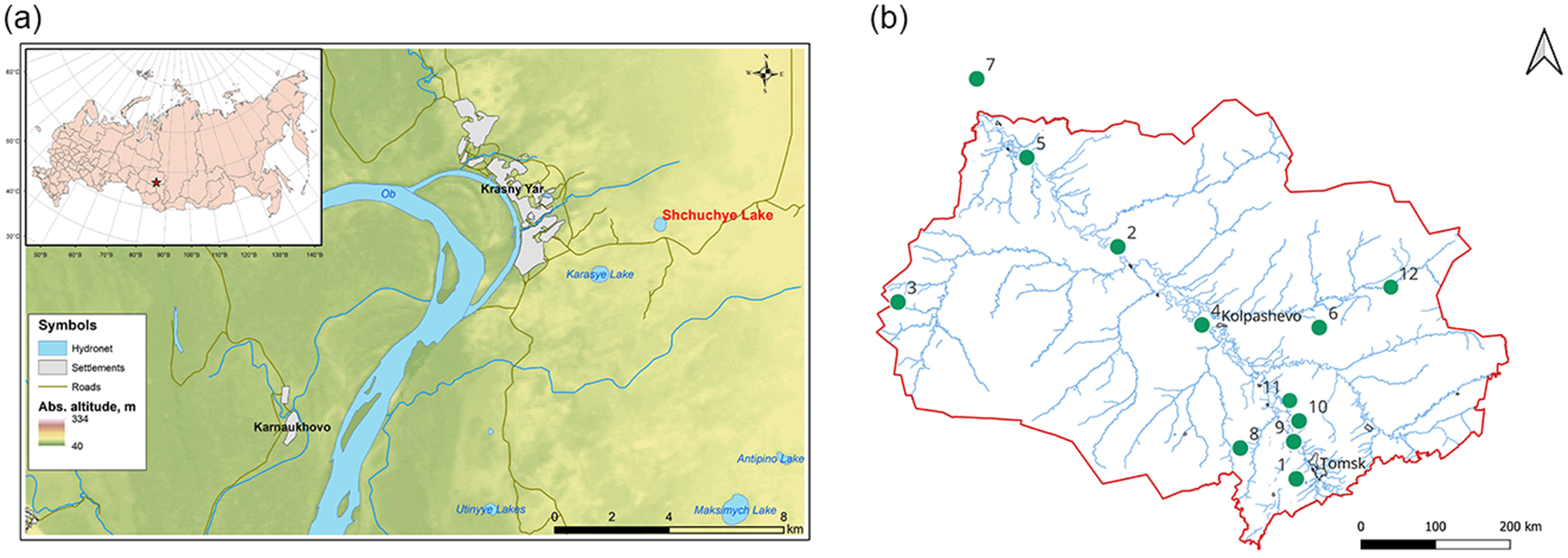
Maps of study area: (a) Location of Shchuchye Lake on terrace of Ob’ River; (b) Location of study lake Shchuchye (10) and neihbouring published pollen sections Zukovskoye bog (1) (Borisova et al. Reference Borisova, Novenko, Zelikson and Kremenetski2011), Entarny (2) (Arkhipov et al. Reference Arkhipov, Levina and Panychev1980), Vodorazdel (3) (Karpenko Reference Karpenko2000), Petropavlovka (4) (Blyakharchuk, Reference Blyakharchuk2012), Lukashkin Yar (5) (Glebov et al. Reference Glebov, Toleiko, Starikov, Zhidovlenko, Abramova, Boch and Galkina1974), Bugristoye (6) (Blyakharchuk and; Sulerzhitsky Reference Blyakharchuk and Sulerzhitsky1999), Nizhnevartovskoye (7) (Neustadt Reference Neustadt1971), Plotnikovo (8) (Feurdean et al. Reference Feurdean, Gałka, Florescu, Diaconu, Tanţău, Kapotin and Hutchinson2019), Ust’e Tomi (9) (Arkhipov and Votakh Reference Arkhipov and Votakh1980), Shchuchye Lake (10), Rybnaya (11) (Feurdean et al. Reference Feurdean, Diaconu, Pfeiffer, Gałka, Hutchinson, Butiseaca, Gorina, Tonlkov, Niamir, Tantau, Zhang and Kapotin2022), Maksimkin Yar (12) (Blyakharchuk Reference Blyakharchuk2012). Maps of key areas were built in ArcGIS 10.6.1. and QGIS 3.32 using the SRTM digital elevation model and OpenStreetMap (osm.org) and NextGIS Data (data.nextgis.com) resources.
Moreover, all of the pollen sections listed above were obtained from peat deposits and, to a certain extent, bear the imprint of the evolution of the bog massif itself, which masks landscape changes in dry lands. For the first time, we provide results of comprehensive palaeoecological studies of a continuous lake sediment record in the territory of Western Siberia covering Late Glacial and Holocene. A sediment core was collected from Lake Shchuchye, located on the right-bank terrace of the great Siberian River Ob’ and a detailed radiocarbon dating chronology was established (8 AMS radiocarbon dates) to modern standards. This record allows a palaeogeographic study tracing how the landscape, vegetation cover, the distribution of permafrost, soil evolution and changes in fire activity have occurred over the past 13,200 calendar years in response to possible forcing mechanisms.
Study area
Shchuchye Lake is a natural basin 3.3 km east of the village Krasny Yar (right bank of the Ob’ River). It is located on the second weakly expressed terrace of the Ob’ River (57.1284 N, 84.60555 E, 80 m a. s. l.) (Figure 1). The maximum depth of the lake water is 7.8 meters, the perimeter 1.48 km and surface area 0.16 km2. On the day of coring, 3 March 2020, the electrical conductivity of water was 59 µS/cm, dissolved oxygen concentration at 1 m depth was 45.2%, pH was 8.5, and the water temperature 1.1°C. Water depth at the coring site was 405 cm. The thickness of the bottom sediment is 345 cm. The vegetation along the banks is represented by birch-pine and pine-birch swampy forest. The lake is surrounded by transitional (sphagnum-forb bog, woody shrub-sphagnum-grass bog and pine sphagnum-sedge bog).
The modern climate in the southeastern part of Western Siberia is continental-cyclonic with long cold winters and short hot summers (Rutkovskaya Reference Rutkovskaya1996, Reference Rutkovskaya1979). Winter is moderately severe, with an average January temperature of –19.1°C. Summers are warm and humid with an average July temperature in the south of the territory of +18.5°C. The number of days with temperature >0°C is 246. The average annual temperature is –0.6°C. The average annual precipitation is 510 mm, of which 2/3 falls in the summer in the form of rain (Rutkovskaya Reference Rutkovskaya1979; Lapshina Reference Lapshina2003). However, depending on the year, annual precipitation can vary from 420 to 600 mm. The longest frost-free period is observed in the river valley of Ob’ River due to the warming influence of large masses of water. Analysis of long-term meteorological data allowed to identify some modern climate change in the study area (Kharyutkina et al. Reference Kharyutkina, Loginov, Usova, Martynov and Pustovalov2019). In the period 1977–1986, the average annual air temperature was 0.4°C. Between 2018 and 2021, the average annual temperature was 1.5°C. That is, there is an increase in temperature in the local area by more than 1°C.
Materials and methods
In the study, we used a multi-proxy palaeoecological investigation of a retrospective series of lake sediment samples to identify long-term changes in climate, vegetation, fires and landscape geochemistry. Lacustrine sediments with a thickness of 345 cm were sampled during the winter expedition. Coring of the lake sediments was carried out from ice using a Livingston piston corer (Wright Reference Wright1991). Extracted lake sediment cores were carefully packaged in plastic liners and transported to the field laboratory of the Koibasovo station, where they were subsampled into samples for spore-pollen, lithological and macro-charcoal analyses at intervals 1-4 cm. The top 90 cm of semi-liquid lake gyttja was collected in a transparent plastic tube and transported in a vertical position to the laboratory, where it was sliced at 1 cm intervals.
To reconstruct the dynamics of vegetation cover, spore-pollen analysis of lake sediment samples was carried out. From the resulting series of samples, 82 subsamples of a standard volume of 1 cm3 were taken for spore-pollen analysis. The intervals between samples were 4–5 cm in the upper 90 cm and 1–4 cm in the underlying sediments. For the lithological analysis by loss on ignition (LOI) (Heiri et al. Reference Heiri, Lotter and Lemcke2001), samples of a standard volume of 1 cm3 were used from the same depths as for spore-pollen analysis. Selected samples were sequentially burned at 105°, 550° and 960°C. After each stage of combustion, the samples were weighed on a precision balance to determine the content of organics, carbonates and mineral fractions. To extract spore-pollen complexes, a standard technique was used (Grichuk and Zaklinskaya Reference Grichuk and Zaklinskaya1948), but propionic anhydride was used for acetolysis according to the latest recommendations (Mazei and Novenko Reference Mazei and Novenko2021). Samples were sieved over 300 and 10 micrometer sieves to remove contamination, using the 10–300 micrometer fraction for spore-pollen analysis. When processing the mineral-rich samples at the base of the core, the Grichuk separation technique was used with a heavy liquid potassium iodide/cadmium iodide (KI/CdI2) with a density of 2.3 g/mL (Grichuk and Zaklinskaya Reference Grichuk and Zaklinskaya1948). The determination of palynomorphs was carried out using a light microscope at a magnification of 400 times. A minimum 500 palynomorphs of tree pollen were identified and counted in each sample and, in addition, pollen of herbs and wetland plants (including spore plants) were counted, as well as NPP (non-pollen palynomorphs) components. Special pollen reference literature (Bobrov et al. Reference Bobrov, Kupriyanova, Litvintseva and Tarasevich1983; Kupriyanova Reference Kupriyanova1965; Kupriyanova and Aleshina Reference Kupriyanova and Aleshina1972; Moore et al. Reference Moore, Webb and Collinson1997; Stivrins et al. Reference Stivrins, Aakala, Pasanen, Kuuluvainen, Vasanda, Gałka, Disbrey, Liepins, Holmström and Seppä2019; van Geel Reference Van Geel1978; van Geel et al. Reference Van Geel, Gelorini, Lyaruu, Aptroot, Rucina, Marchant, Sinninghe, Damsté and Verschuren2011) and reference collection of pollen slides from plants of the local flora were used for plant species identification. Interpretation of pollen data is based on ecology of species, known pollen productivity and ways of pollen dispersion, as well as on results of study of modern pollen spectra (Blyakharchuk Reference Blyakharchuk2017; Blyakharchuk et al. Reference Blyakharchuk, Nokolaeva and Dolgikh2023)
Radiocarbon dating of 8 bulk sediment samples was carried out at the SUERC AMS laboratory (Scottish Universities Environmental Research Centre, East Kilbride, Scotland, UK). The obtained radiocarbon dates were calibrated using IntCal20 in the rbacon package version 3.1.1 (Christen and Pérez Reference Christen and Pérez2009; Blaauw and Christen Reference Blaauw and Christen2011) in R (R Core Team R 2020) with constructing of age-depth model (Figure 2). Microcharcoal particles were counted together with pollen and presented in pollen diagrams in absolute counts.
The Bayesian age-depth model for the Shchuchye Lake record, calibrated using the IntCal20 calibration curve and the radiocarbon data presented in Table 1. Outlier at 160 cm depth indicated by red X.

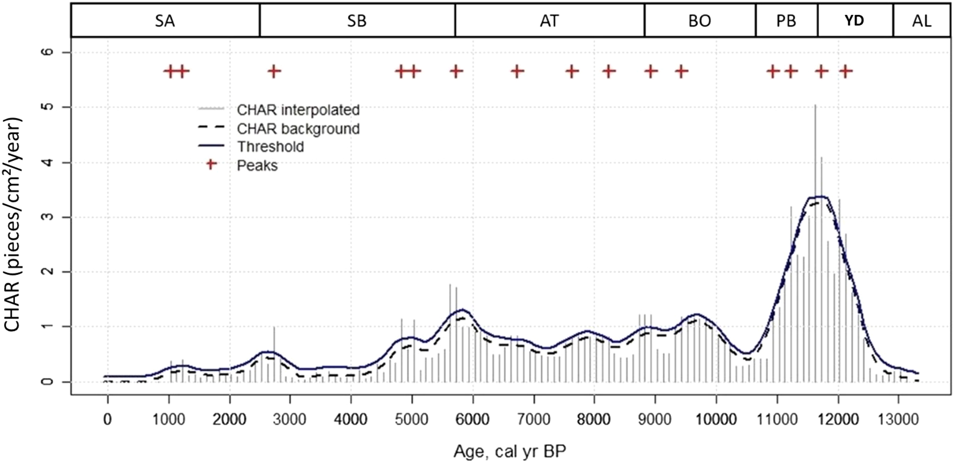
To reconstruct the local history of palaeofires, the method of macro-charcoal analysis was used (Whitlock and Larsen Reference Whitlock, Larsen, Smol, Birks, Last, Bradley and Alverson2001; Mooney and Tinner Reference Mooney and Tinner2011). Charcoal particles preserved in sediments (>125 µm in size) serve as indicators of local pyrogenic episodes. Counting the number of macroscopic charcoal particles in each sediment sample allows us to reconstruct the long-term dynamics of local palaeofires. Standard volume subsamples (2 cm3) were collected from sediment cores at intervals of 1–2 cm. All 170 subsamples of lake sediment were washed with distilled water and sifted through a 125 micrometer sieve. After washing and sieving, a 15 mL solution of sodium pyrophosphate (Na4P2O7) was added to the samples and left for a day, followed by washing with distilled water. Then a 6% solution of hydrogen peroxide H2O2(20 mL volume) was added and kept for at least 48 hours (Whitlock and Larsen Reference Whitlock, Larsen, Smol, Birks, Last, Bradley and Alverson2001; Mooney and Tinner Reference Mooney and Tinner2011). These processing steps contribute to the discoloration of organic matter, making it possible to clearly distinguish and count black charcoal particles under a binocular microscope at x45 magnification using a Bogorov counting tray. All charcoal particles were counted in each processed subsample. Statistical analysis of the obtained macro-charcoal data was carried out using the CharAnalysis software package (Higuera Reference Higuera2009), adapted for the R programming environment (R Core Team R 2020). Using this program, the rate of accumulation of charcoal particles was calculated (Figure 3). In addition, the program determined background and threshold values for separating local (within a radius of 1-3 km from the research point) fires from regional (at a distance of up to 20 km) and identified specific fire episodes. For chronological control, an age-depth model of sediments from Shchuchye Lake was used (Figure 2). When calculating the background and threshold values of the accumulation rates of charcoal macroparticles, the statistical function LOESS (locally estimated linear regression) with a smoothing period of 1500 years was used. The time window for determining local fire episodes by identifying values exceeding background indicators was 13,000 years. In addition, for statistical reliability of the time window, the dimensionless signal-to-noise index (SNI) was used (Kelly et al. Reference Kelly, Higuera, Barrett and Hu2011). In this case, SNI ranged from 2.4 to 3.2, which satisfies the statistical requirements of the analysis.
Changes in the accumulation rate of macro-charcoal in sediments of Shchuchye Lake, calculated based on the absolute count of macro-charcoal using the CharAnalysis software package. Blitt-Sernander climatic periods: AL—Allerød; YD—Younger Dryas; PB—Preboreal, BO—Boreal; AT—Atlantic; SB—Subboreal; SA—Subatlantic.
The diagrams and CONISS cluster analysis of pollen data were done with Tilia software (Grimm Reference Grimm2004) version 2.0.41. Cluster analysis was performed in the same program. Components in pollen diagrams are represented in % from total sum of counted pollen and spores without spores and pollen of local wetland plants such as (Bryales/Algae and Cyperaceae). For better understanding of vegetation structure, we counted relationships between gropes: Trees, Shrubs, Dryland herbs, Water plants, Spore plants. It it presented in joint graphic at left side of pollen diagram (Figure 4). This joint graphic illustrates in more detail the relationship AB/NAB, where AB (arboreal pollen) is represented by sum of pollen of tree species, and NAB (nonarboreal) is represented by sum of all other pollen and spores types. Individual pollen types (recognized to species, genus or family) are grouped from left to right as follow: Trees, Shrubs, Dryland and ruderal plants, where we included also cultivated plants (Triticum and Avena), Wetland plants which include pollen of wetland plants, water plants, both pollen and spores. The last group represents selected non pollen palynomorphs—NPP. The last group gives additional information about landscapes processes: Glomus—soil erosion, microcharcoal and Gelasinospora—fires, Pediastrum and Nuphar spicula—lake condition). Only selected most abundant or most informative pollen types of herbs are included in diagrams due to space limitations.
Spore-pollen diagram of bottom sediments of Shchuchye Lake. Percentages are calculated from the total pollen and spores sum excluding the Bryales/Algae group. The components of the NPP group are presented in absolute values.

Reconstruction of quantitative parameters of palaeoclimate, such as: mean July temperature, mean January temperature, annual amount of precipitation and number of free of frost days were made using the method of Bukreeva (Bukreeva et al. Reference Bukreeva, Arkhipov, Volkova and Orlova1995), where formulas are based on step-by-step regression analysis of 135 modern pollen spectra from the territory of the forest-tundra, taiga, small-leaved forests and forest-steppe zones of Western Siberia and the corresponding climatic parameters. Reconstructed palaeoclimatic parameters are given in deviations from the modern values (Δ) (see Figure 6). According to Bukreeva et al. (Reference Bukreeva, Arkhipov, Volkova and Orlova1995), pollen from spruce (Picea obovata), pine (Pinus sylvestris), fir (Abies sibirica), birch (Betula pendula), Siberian cedar (Pinus sibirica), dwarf birch (Betula nana) and alder (Alnaster fruticosus) have strong relationships with climatic parameters. For Tjuly and Tjanuary regression coefficients are very high (R=0.83–0.85), and standard deviations are small (s=1–1.4°C) and average error (Q=5–7%). For annual precipitation the coefficient was lower (R=0.5, s=51mm, Q=8%). In general, pollen of selected tree species are associated with the maximum number of climate elements in Western Siberia, based on a set of modern samples from the forest-tundra, taiga, deciduous forests and forest-steppe of this region (Bukreeva et al. Reference Bukreeva, Arkhipov, Volkova and Orlova1995). These tree and shrub species have clearly defined ecological optimums and tolerance limits for each climate factor. This is confirmed by the specific distribution of the modern range of each species in a certain geographical zone with specific soil-ecological conditions in the general vegetation cover of Western Siberia (Shumiliva Reference Shumiliva1962).
Combined data from lithological and charcoal analysis with diagnostic pollen types. Abbreviations for the Blitt-Sernander classification of climate periods follow Figure 3. Known periods of cooling are highlighted with gray shadow. Red stars indicate episodes of local fires identified by the CharAnalysis program. To visualise variation in low microcharcoal count, the x-axis was truncated at 400 counts and asterisks indicate where microcharcoal values are >400.

Quantitative reconstructions of palaeoclimate based on pollen data from Shchuchye Lake using the formulas of Bukreeva et al. (Reference Bukreeva, Arkhipov, Volkova and Orlova1995). Reconstructions are given in deviations from modern values (Δ). Abbreviations for the Blitt-Sernander classification of climate periods follow Figure 3.

For the palaeoreconstructions we used the following formulas:
TJuly = 18.1–0.18*Bnana-0.1*Pic+0.01*Psyl-0.05*Alnas-0.01*Psib+0.05*Abi (R=0.83; σ=1°C; Q=7%), where: Bnana—pollen of Betula nana; Pic—Picea obovata; Psyl—Pinus sylvestris; Alnas - Alnaster; Psib—Pibus sibirica; Abi—Abies sibirica
TJanuary = –22.6+0.05*Psyl+0.03*Bet+0.16*Abi-0.14*Bnana-0.09*Pic-0.05*Alnas-0.035*Psib (R=0.85; σ=1.4°C; Q=5%), where: Psyl—Pinus sylvestris; Bet—Betula pendula and Betula alba; Abi—Abies sibirica; Bnana - Betula nana; Pic—Picea obovata
Annual precipitation = –90.4–1.3*TR+7.2*Pic+1.9*Bnana+5.8*Psyl+8.7*Alnas+7.6*Abi+6.3*Bet+6.2*Psib+5.0*Sal (R=0.5; σ=51 mm; Q=8%), where: TR—sum of herbs pollen; Pic—Picea obovata; Bnana - Betula nana; Psyl—Pinus sylvestris; Alnas—Alnaster; Abi—Abies sibirica; Bet—Betula pendula and Betula alba; Psib—Pibus sibirica; Sal - Salix
Number of free-frost days = 126–0.28*Psib-1.3*Bnana-0.7*Pic-0.13*DR-0.82*Sal-0.61*Alnas (R=0.7; σ= 7 days; Q=7%), where: Psib—Pibus sibirica; Bnana - Betula nana; Pic—Picea obovata; DR—pollen of trees; Sal—Salix; Alnas—Alnaster
When interpreting multi-proxy data, we used the strong fuzzy EHLFS conceptual approach (Environmental-Human-landscape Feedbacks and Synergies) (Rull Reference Rull2018), which considers multiple number of facts to test various lines of evidence.
Results
Radiocarbon dating of sediments
The results of radiocarbon dating using the AMS method are presented in Table 1.
Radiocarbon (AMS) dates for the Shchuchye Lake sediment record
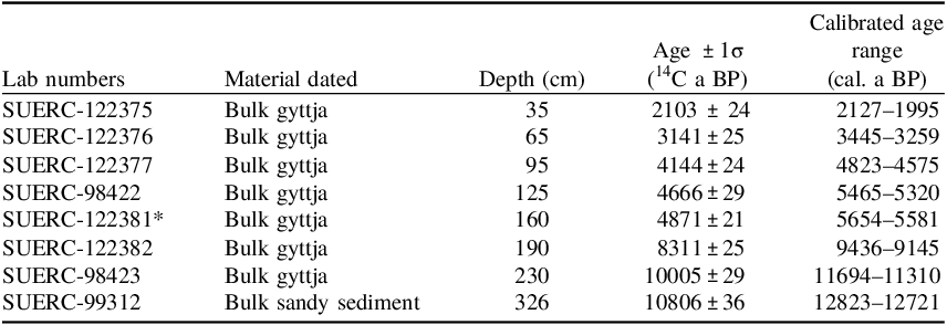
* Radiocarbon date not used in age-depth model.
In general, all the obtained radiocarbon dates are in the correct sequence without inversions. However, two dates from depths of 125 and 160 cm appear to be too close in time (5465–5320 cal ka BP and 5654-5581 cal ka BP, respectively), indicating a possible contamination. We did not find any evidence of a sedimentation hiatus in the lithological and palaeoenvironmental data near this level. Therefore, when constructing the age-depth model (Figure 2), we did not include the date 4871±21 from depth of 160 cm, considering it as an outlier, probably caused by inclusion of younger material. We also note the large uncertainty in the age model between 135–185 cm depth with 95% confidence intervals of 850–2890 years. Consequently, we took care when interpreting the exact timing of events, especially between 9–5.5 cal ka BP, although this period is relatively stable with regards to vegetation and fires, so the impact of this uncertainty is limited.
The age-depth model showed a very high average sedimentation rate in the initial period of 13.2–11 cal ka BP (0.5–1.0 mm/yr). During the period 11–7 cal ka BP, the sedimentation rate decreased (0.1–0.5 mm/yr). This was followed by two millennia with an increased rate of accumulation (0.2–0.6 mm/yr) of lacustrine gyttja 6–4 cal ka BP. After 4 cal ka BP, the accumulation rate decreased again (0.2–0.3 mm/yr). The high initial rate of sedimentation can be connected with sedimentation of sand in the part of this section below 285 cm. The lowest radiocarbon date in the sequence is at 326 cm, in sandy sediments, and although it is likely that sedimentation rates declined after the transition to gyttja, there was no fundamental difference in the shape of two Bayesian age-depth models with and without boundary at 285 cm depth, hence we use the simplest model (without boundary).
Results of macro-charcoal analysis
Over the entire period of the existence of Shchuchye Lake, 15 local fire episodes occurred, identified by via CharAnalysis (Figure 3). At the end of the Allerød, no local fires were noted, and starting from the Younger Dryas, the intensity of fires gradually increased, leading to 2 fire episodes at 12.5 and 11.8 cal ka BP with a charcoal accumulation rate of up to 3.5 particles/cm2/year. The maximum intensity of fire occurred at the end of the Late Glacial and the beginning of the Preboreal period of the Holocene—2 palaeofire peaks (12.1, 11.0 cal ka BP), reaching the maximum values in charcoal accumulation rate for this record—5 particles/cm2/year in the middle of the period. This is likely a conservative estimate as sediment accumulation is also highest during this period. It is likely that at this time a series of large fires occurred directly near Lake Shchuchye. After the Preboreal, the charcoal accumulation rate decreases sharply (only 0.5–1.2 particles/cm2/yr during Boreal and Atlantic periods), and only 2 local fire episodes were noted in the Boreal (9.5, 9.0 cal ka BP) and 4 in the Atlantic period (8.2, 7.6, 6.8 and 5.8 cal ka BP). In the Subboreal period charcoal accumulation rates decrease further (0.4–0.6 particles/cm2/year at the beginning of the period to 0.4–0.1 particles/cm2/year at the end of the Subboreal) with 3 local fire episodes (5.0, 4.8 and 2.8 cal ka BP). The Subatlantic period within Shchuchye Lake is characterized by a fairly low intensity of fires, with 2 local fire episodes—1.1 and 1.0 cal ka BP and charcoal accumulation rates below 0.4 particles/cm2/yr. After 1.0 cal ka BP there are no data on fire dynamics for Shchuchye Lake because there was insufficient material for charcoal analysis.
4.1. Data of spore-pollen (Figure 4 ), lithological and charcoal analyses (Figure 5 )
The spore-pollen diagram of the bottom sediments of Shchuchye Lake reflects the dynamics of the vegetation cover of the southern taiga of Western Siberia from the Late Glacial 13.2 cal ka BP to the present (Figure 4). The study identified 98 taxa of palynomorph, including 8 tree species, 8 shrub species, 9 types of redeposited and long-distance pollen, 65 types of herbs, 7 types of spore plants and 11 types of non-pollen palynomorphs (NPP) (Table A.1).
Based on the dominant groups of fossil pollen, the pollen diagram is divided into 5 local pollen zones (LPZ), which are confirmed by cluster analysis (Figure 4). The two lower pollen zones have subzones “a” and “b”. We provide a description of pollen zones from older (bottom) to modern (top) times.
-
LPZ-1a—Larch and grasses, depth 341–300 cm, age 13.1—12.5 cal ka BP. The zone covers the lower layers of sandy sediments of the lake (Figure 5). Characteristic of the zone is the dominance of spores with a low abundance of arboreal (AB) pollen. The AB pollen group is dominated by larch pollen. Spruce and birch pollen is found in small quantities. The abundance of dwarf birch (Betula nana) pollen is increased (Figure 5). The zone under consideration is also characterized by an increased abundance of grass pollen (NAP) with dominance of wormwood (20%) and grasses (up to 20%). The percentages are calculated from the total number of counted pollen and spore grains minus the local component of spectrum— Bryales/Algae. There are high values for pollen of Thalictrum, an indicator of the open spaces (Blyakharchuk, Reference Blyakharchuk2017). The species diversity of herbs is high, with many Aster type, Caryophyllaceae, Androsace and fire indicator Epilobium angustifolium (Prokop’ev, Reference Prokop’ev2003, page 316). Among the local spore plants there are many fern spores (Monolete fern spores) and green moss spores (Bryales/Algae). In the NPP group, micro-charcoal is very abundant, and fungal spores (spores of the soil fungus Glomus and the fire indicator Gelasonospora (Stivrins et al., Reference Stivrins, Aakala, Pasanen, Kuuluvainen, Vasanda, Gałka, Disbrey, Liepins, Holmström and Seppä2019) are constantly present). Pollen and microcharcoal concentrations in bottom sediments at the depth 326-341 cm are very low (based on the high count of Lycopodium spores added as marker) and this correlates well with low values of macrocharcoal. Exotic pollens are encountered—Pterocarya (depth 321, 325-331), Tsuga (depth 331 cm), Ulmus (depth 311 cm), but in small quantities varying from 1 to 5 grains per sample, indicating presence of weak redeposition of material.
-
LPZ-1b—Spruce, wormwood and grasses, depth 300–285 cm, age 12.5–12.2 cal ka BP. Sediments in this zone start from high mineral content with fine structure, then change abruptly to organic lake gyttja (Figure 5). The ratio of tree pollen (equivalent to AB—arboreal pollen) to sum of other pollen and spore types (equivalent to NAP—nonarboreal pollen) is generally similar to the previous LPZ-1a subzone (Figures 4, 5). However, a distinctive feature of this subzone is the sharply increased abundance of pollen of wetland plants, among which Carex pollen dominates. Among the tree species of the AB group, the abundance of spruce (Picea obovata) pollen has sharply increased reaching 20%. The abundance of larch pollen (Larix) is significant at the beginning of the subzone (20%) and sharply decreases to 5% at the end of the subzone.
Subzone LPZ-1b is also characterized by a low abundance of birch pollen. Pollen of wormwood and grasses is still abundantly represented. Herbs are varied. Maximum abundance have spores of ferns and green mosses. Among the NPPs, the maximum abundance of the soil fungus Glomus, fire indicator Gelasinospora and Fungal spores are noted. Pollen of dwarf birch sharply decreased.
-
LPZ-2a—Birch and dwarf birch, depth 285–225 cm, age 12.2–11.16 cal ka BP. The pollen zone is distinguished by the maximum abundance of pollen of the dwarf birch and a progressive increase in the abundance of pollen of the tree birches Betula pendula and Betula alba. In general, compared to the previous zone, the abundance of arboreal pollen (AB) increases slightly (Figure 5), along with an increase in the abundance of shrubs and herbs, especially with xerophytic ecology (Artemisia, Poaceae, Ephedra, Stipa) (Figure 4). The abundance of dwarf birch again increases to a maximum (up to 40%). However, the abundance of coniferous tree species Picea and Larix is sharply declining. Spores (Bryales/Algae and Monolete fern spores) are still abundantly represented in the spectra. Changes occur in the wetland plants, where sedge pollen decreases sharply and pollen of aquatic macrophytes Nuphar and Nymphaea appear and remain permanently present since then. The abundance and species diversity of mesophytic herbs is somewhat reduced. The NPP group is characterized by the appearance of a large number of Nuphar spicula, but the spores of the soil fungus Glomus and redeposited exotic pollen of Pterocarya, Tsuga and, Ulmus (see description of LPZ-1a) practically disappear. The abundance of micro-charcoal also decreases, although the abundance of macro-charcoal progressively increases.
-
LPZ-2b—Tree birches, depth 225–200 cm, age 11.16–10 cal ka BP. This is the only section of the record that is very rich in carbonates (up to 30%). The sediments are low in organic matter (as low as 20%), which is much lower than in the periods before LPZ-2b, when organic matter content reached 85% (Figure 5). The subzone is characterized by the maximum abundance of Betula pendula pollen in the AP pollen group. Characteristic is a progressive increase in the abundance of pollen from woody plants and a decrease in the role of spore plants and shrubs. This trend is expressed in a directional decrease in the abundance of Betula nana pollen and an increase in the abundance of tree birch pollen. However, pollen of conifers (Pinus sylvestris, Pinus sibirica, Abies sibirica) are still absent from the spectra. Spruce is represented in small abundance. The abundance of grasses (Poaceae), aquatic macrophytes and green mosses decreases. In the NPP group, Nuphar spicula and the fire indicator Gelasinospora disappear as well as the abundance of micro- and macro-charcoal.
-
LPZ-3—Scots pine and birch, depth 200–125 cm, age 10–5.7 cal ka BP. Sediment organic matter content increases again (up to 65%) while carbonate and mineral components decrease (Figure 5 ). This pollen zone is characterized by a stable dominance of AP pollen over NAP. The content of spores sharply decreases and the abundance of pollen of shrubs and grasses decreases (Figure 4). In the group of tree pollen, Scots pine (Pinus sylvestris) suddenly appears and reaches high values (30–40%). The abundance of fir (Abies sibirica) appears and increases quite quickly to 6–8% between 10–9 cal ka BP. From the beginning of the zone, single pollen grains of Siberian cedar (Pinus sibirica) appear, but its progressive increase begins only in the second half of the zone after 8 cal ka BP. With the onset of LPZ-3, the abundance of pollen from dwarf birch, as well as wormwood and grasses, sharply decreases. The pollen of the open space indicator Thalictrum, the spores of ferns and green mosses almost disappear. In the NPP group there is very little micro-charcoal, but macro-charcoal is abundant. Soil erosion indicators Glomus and Gelasinospora completely disappear. At a depth of 175 cm (age 8.2 cal ka BP), the lithological composition (Figure 5) shows a small maximum of carbonates, immediately followed by an increase in the mineral content and a decrease in the organic fraction. In the pollen spectrum, this fluctuation is marked only by a decline in the abundance of fir pollen and the beginning of the spread of Siberian cedar. A local fire period was also recorded around 8.2 cal ka BP.
-
LPZ-4—Siberian cedar, fir, pine and birch, depth 125–25 cm, age 5.7–1.3 cal ka BP. This zone is distinguished by the maximum abundance of cedar (Pinus sibirica) and fir (Abies sibirica) pollen. The zone is characterized by a slight decrease in the abundance of arboreal pollen and an increase in the abundance of spores (Figure 4). Compared to the previous zone, the abundance of pollen of shrubs and grasses decreases slightly, reaching the lowest values for the entire record. In the tree pollen group, against the background of a higher abundance of Abies sibirica and Pinus sibirica pollen, the abundance of Betula pendula and Pinus sylvestris pollen slightly decreases. In this zone, the abundance of pollen from spruce and dwarf birch, wormwood and grasses is minimal. The abundance of Spiraea pollen decreases slightly, but the abundance of moss spores increases. In the NPP group, the abundance of macro-charcoal decreases; fungal spores, Gelasinospora, and the algae Pediastrum are found sporadically.
-
LPZ-5—Birch and pine, depth 22–0 cm, age 1.3 cal ka BP—modernity present. This pollen zone is largely similar to LPZ-4 but is distinguished by a clear decrease in the abundance of fir pollen and a slight increase in the abundance of Scots pine pollen. Cedar pollen also becomes slightly less than in the previous zone. The abundance of silver birch (Betula pendula) pollen decreases slightly, but the content of downy birch (Betula alba) and dwarf birch (Betula nana) pollen increases. A distinctive feature of the zone is also an increase in the abundance of wormwood pollen (Artemisia) and the appearance of pollen grains of anthropogenic indicators (Cannabis, Plantago, Triticum, Avena). The general composition of the spectrum is dominated by pollen of woody plants, as in the previous zone, but the abundance of pollen of shrubs and grasses has increased slightly. The abundance of spores decreased noticeably. In the NPP group, the abundance of micro-charcoal slightly increased, and the beginning of an increase in the abundance of macro-charcoal was recorded. Unfortunately, the semi-liquid gyttja contained very little solid residue, and this did not allow lithological and macro-charcoal analyzes of the top 20 samples. Therefore, information on these indicators for the last thousand years is not available.
Quantitative reconstruction of palaeoclimate parameters
Results of quantitative reconstruction of average July and average January temperatures, as well as annual precipitation and duration of the frost-free period according to the formulas proposed by G.F. Bukreeva (Bukreeva et al. Reference Bukreeva, Arkhipov, Volkova and Orlova1995) are presented in Figure 6.
Because pollen of spruce (Picea obovata), pine (Pinus sylvestris), fir (Abies sibirica), birch (Betula pendula), Siberian cedar (Pinus sibirica), dwarf birch (Betula nana) and alder (Alnaster fruticosus) are associated with number of climate elements in Western Siberia (see chapter Materials and methods), and these plant species have clearly defined ecological optimums and tolerance limits for each climate factor conformed by their modern range in a certain geographical zones of Western Siberia (Bukreeva et al. Reference Bukreeva, Arkhipov, Volkova and Orlova1995) we consider that changes in their relative abundance in the past should reflect corresponding changes in climatic and environmental conditions. The resulting quantitative reconstructions of palaeoclimate based on pollen data from Shchuchye Lake using the formulas of Bukreeva (Reference Bukreeva, Arkhipov, Volkova and Orlova1995) given in Figure 6 demonstrate that major climatic changes in study area took place in Late Glacial and Early Holocene before 10 cal ka BP. During most of the Holocene the wiggles of quantitative reconstructions of palaeoclimate are smaller than 1 degree (stay within the uncertainty band) and not significant statistically. Reconstructions of annual precipitation are significant only for period before 10 cal ka BP and for Subboreal period. It should be noted, also, that the quantitative reconstructions we obtained may have deviations from the real ones for the Late Glacial period due to the presence of Late Glacial pollen spectra that do not have modern analogues. Nevertheless, taking into account the mentioned uncertainties we provide a description of quantitative reconstructions of palaeoclimate according to the Blitt-Sernander classification for climate periods.
-
AL—Allerød. The oldest pollen spectra revealed from the sandy sediments underlying the lacustrine gyttja coincide by time with the interstadial warming of Allerød. Quantitative reconstructions of palaeoclimate show the rather harsh climatic conditions that existed in the study area at that time. Thus, the average July temperatures were lower than modern temperatures by 3.5°C, and the average January temperatures by 4.5°C. However, the annual precipitation was especially low and was 230 mm lower than today. The duration of the frost-free period was 15 days less than today.
-
Younger Dryas (YD). The stadial cooling of the Younger Dryas was clearly manifested in palaeoclimate reconstructions based on pollen data from Shchuchye Lake. However, climate changes during this period were not unambiguous. The beginning of the YD is marked by a slight decrease in January temperatures by ∼1.8°C and July temperatures by ∼1°C (compare with the Allerød), a sharp decrease in the abundance of atmospheric precipitation (400 mm lower than modern ones) and the duration of the frost-free period (10 days less than in the Allerød). However, this was followed by a sharp episode of warming in the middle of the YD, especially in the summer. The mid-July temperature has almost reached modern values, remaining below modern ones by only 1.5°C. Average January temperatures were still 3.3°C lower than today. Annual precipitation was still low. And the duration of the frost-free period increased by 20 days compared to the previous period and even slightly exceeded modern values. In the second half of Younger Dryas, cold conditions return. Average July and average January temperatures were 6–7°C lower than modern values. The duration of the frost-free period decreased especially sharply; it became 40 days shorter than the modern one. Against this background, there was an overall increase (although highly variable) in the annual amount of precipitation and by the end of the YD it was only 170 mm lower than today.
-
PB—Pre-Boreal period. The beginning of the Holocene was marked by a sharp, rapid warming. In less than a century, July and January temperatures became 3°C warmer compared to the YD cold period. During the same time, the duration of the frost-free period increased again by 20 days. Since the beginning of PB, the annual amount of precipitation began to increase, reaching modern values by the end of the Pre-Boreal. By the end of PB, temperatures in July and January had risen so much that they were only 1.6°C lower than modern ones, ∼5°C warmer than during the YD. The duration of the frost-free period towards the end PB almost approached the modern one.
-
BO—Boreal period. During the boreal period, average July temperatures increased so much that they reached modern values, and by the end of the period ∼9 cal ka BP they became higher than modern ones—by 0.5°С, and January temperatures by 1ºС. The annual amount of precipitation fluctuated around modern values, only in the middle of the period exceeding them by 50 mm (that is near the uncertainty band) and statistically not significant. The duration of the frost-free period in BO was generally longer than at present by 2–6 days. This is probably how the boreal climatic opt manifested itself in the southern taiga zone of western Siberia.
-
AT—Atlantic period. The climatic optimum of the Boreal period ended at the beginning of the Atlantic period around 8.2 cal ka BP. The average July and average January temperatures, having reached modern values, stabilized in the AT. Precipitation also stabilized, but at values 50 mm higher than modern at the beginning of the period and by 20 mm during the rest of the AT. Cooling that occurred 8.2 cal ka BP, accompanied by climate humidification, returned temperature parameters to modern values. This is probably how global cooling of 8.2 cal ka BP manifested itself in the southern taiga of Western Siberia.
-
SB—Subboreal and SA—Subatlantic periods. During these periods average July and January temperatures were close to those in AT undergoing constant but very small fluctuations staying close to modern. Because temperature fluctuations staid mostly within uncertainty bands (fluctuating from 0.5°C to 1.5°C) we can conclude that climatic condition were stable close to modern (with very minor fluctuations) and, except perhaps annual precipitation, which was higher than modern during Subboreal period when the amount of precipitation was more than in the AT and exceeded modern values by 70–100 mm. The duration of the frost-free period was also close to the modern one during last 10,000 calendar years.
Discussion
Compilation of changes in vegetation cover, climate, landscape geochemistry and fires from multi-proxy data in the eastern sector of the southern taiga zone of Western Siberia
The comprehensive palaeoecological study of this lake sediment record from Shchuchye Lake, revealed Late Glacial and Holocene dynamics of climate, vegetation cover, geochemical changes in the landscape and its burning that occurred in the last 13,000 calendar years. We present a reconstruction of these changes based on the identified pollen zones with the events linked to the Blitt-Sernander geochronological scale (Figure 5), taking into account the large age uncertainties between 9 and 5.5 cal ka BP.
-
1. Phase of spruce tundra-forest-steppe (LPZ-1a bottom). It is represented by only a few lower spore-pollen spectra extracted from the sandy sediments underlying the lake sediments. The phase characterizes the vegetation cover of the study area during the period of interstadial warming Allerød. The basis of the vegetation cover was shrub-moss-grass tundra-steppe with islands of spruce forest in river valleys, where the permafrost cover in the soils began to decrease, creating sufficient local moisture for spruce (forest-tundra-steppe). Probably, the local degradation of permafrost was started by the extension of frost-free summer periods caused by increased solar insolation of the northern hemisphere during the summer seasons in the post-glacial and early Holocene times (Berger 1978; Berger and Loutre Reference Berger and Loutre1991). The dry and relatively cold Allerød climate was not conducive to fires, which is confirmed by the small number of micro- and macro-charcoal particles concentration. The shrub cover was represented by thickets of dwarf birch, spirea and willows. A similar plant community of dwarf birch (Betula nana), spirea (Spirea alpina) currently forms a shrubby altitudinal belt in the Altai Mountains on the border between the mountain forest belt and the alpine vegetation belt (Kuminova Reference Kuminova1960), which could be seen as a modern analogue for Allerød vegetation in study area. The herb cover was represented by vast open spaces covered with meadow-grass vegetation in which, on dry areas the role of wormwood (Artemisia) and grasses (Poaceae) increased, and on more wet places mosses dominated. In general, such vegetation cover provided an excellent food base for glacial megafauna (Leshchinskiy and Burkanova Reference Leshchinskiy and Burkanova2022).
-
2. Phase of larch tundra-forest-steppe (12.8–12.5 cal ka BP)(LPZ-1a). Judging by quantitative reconstructions of the late-glacial palaeoclimate, the climate of this phase was extremely unstable (Figure 6). Its severity increased sharply due to lower temperatures in July and January, but mainly due to the sharp drying of the climate. This led to the disappearance of spruce from forest patches. It was replaced by larch, which is capable of growing on permafrost soils, as is currently the case in vast areas of Eastern Siberia (Shumiliva Reference Shumiliva1962). The increase in permafrost in the soils made them drier and unsuitable for spruce, which disappeared, and the herbal cover was dominated by meadow-steppe species with a significant role of wormwood (Artemisia). Species from the families Asteraceae and Caryophyllaceae, Poaceae of the genus Androsace and the heliophyte Thalictrum were abundant. The absence of pollen of aquatic macrophytes indicates that the water table was extremely low in Shchuchye Lake during this period. It was just wetland hollow. The abundance of spores of the soil fungus Glomus also indicates the dry soil regime and widespread soil erosion (Van Geel et al. Reference Van Geel, Gelorini, Lyaruu, Aptroot, Rucina, Marchant, Sinninghe, Damsté and Verschuren2011). It is possible that during this dry and cold period (according to our reconstructions, atmospheric precipitation fell 400 mm less than today’s) the blowing of sand on the Ob’ River terraces intensified. The quartz particles of these deposits mostly have a rounded, rolled shape with traces of the influence of aeolian processes—micropits (Figure A.1). Numerous micropits on the surface of rounded quartz grains are consequences of the collision of sand grains during their transport by air (Velichko et al. Reference Velichko, Timireva, Kremenetski, MacDonald and Smith2011). They indicate dry and frozen conditions (cryoarid) that existed not only in the north and middle parts of Western Siberia, but also in the southeast of the plain in the study area. Strong winds and sand movement might also have ground larger macro-charcoal particles into micro-charcoal increasing number of the last (Figure A1). In addition, this phase is characterized by a large abundance of spores of the fungus Gelasinospora, which have also been used as indicator of local fires (Stivrins et al. Reference Stivrins, Aakala, Pasanen, Kuuluvainen, Vasanda, Gałka, Disbrey, Liepins, Holmström and Seppä2019; Van Geel Reference Van Geel1978). Finally, it is in these deposits that Epilobium angustifolium pollen is found, which is a typical post-fire disturbed soils colonizer (Prokop’ev Reference Prokop’ev2003). The presence of two indicators of local fires suggests that local fires occurred frequently during the YD cooling period but were not recorded by the abundance of macro-charcoal, possibly due to abrasion by sand and aeolian processes resulting in presence of micro-charcoal only, but at high abundances (Figure 5). Thus, palaeoecological data recorded the exact time frame of the cryoarid period in the development of landscapes in the southeastern sector of the southern taiga in the West Siberia, which took place ∼12.8–12.5 cal ka BP and was probably accompanied by the movement of dune sandy deposits. The arid climate in Western Siberia at this time was due to the fact, that a significant part of the Arctic and North Atlantic was covered with pack ice (Velichko et al. Reference Velichko, Timireva, Kremenetski, MacDonald and Smith2011). At the same time, the area covered by the influence of the high pressure of the Siberian anticyclone expanded significantly. As a result of these freezing and dry conditions, permafrost was distributed almost throughout the entire territory of Western Siberia (Baulin Reference Baulin1985; Velichko Reference Velichko, Velichko, Wright and Barnosky1984).
-
3. Phase of spruce tundra-forest-steppe (12.5–12.2 cal ka BP, LPZ-1b). During this short period of ∼350 years, it is likely that the intensity of the YD cooling factor weakened, which resumed the warming effect of increased solar insolation during the summer in the northern hemisphere. Other studies have also observed regional variations with warmer summers during the YD period, explained by atmospheric blocking of cold Westerly winds by the Fennoscandian Ice Sheet (Schenk et al. Reference Schenk, Väliranta, Muschitiello, Tarasov, Heikkilä, Björck, Brandefelt, Johanssen, Naslung and Wohlfarth2018). At Shchuchye Lake, July and January temperatures and the duration of the frost-free period sharply increased during these 350 years, which led to degradation of permafrost. In places where permafrost thawed, local soil moisture increased, and spruce was able to settle along with larch. Spruce, unlike larch, is an evergreen species. Its crown produces more shade all year round. This created unfavorable conditions for heliophilous plants such as Betula nana and Thalictrum. As a result, their role in vegetation has sharply decreased. At the same time, one can see the synchronous spread of sedge (Carex) during the rapid change from mineral to organic sediment (Figure 5, Figure A.1). At the beginning of thawing, sedges spread in the thermocarst depression and spruce settled around the basin, while local soil moisture increased. However, the climate still remained cold and dry (cryo-arid) and xerophytic herbs and shrubs (Artemisia, Poaceae, Ephedra) dominated in the dry areas. This was a transitional stage in the transformation of the landscape from a situation with widespread permafrost (continuous permafrost in soil) to one where permafrost degraded and partly disappeared (discontinuous permafrost in soil).
-
4. Phase of shrub birch forest-steppe (12.2–11.2 cal ka BP, LPZ-2a). This phase in the development of the landscape covers the last part of the YD and the first half of the PB. During this phase, which lasted approximately 1000 years, the landscape continued to actively change. The vegetation cover in the second half of the YD consisted of vast areas with dwarf birch shrub and islands of woody vegetation of tree birches (Betula pendula and Betula alba) in the floodplain of the Ob’ River and its tributaries, and in the depressions around newly formed lakes. In such areas the permafrost roof sank to greater depth and local moisture allowed woody vegetation to establish themselves. In higher watershed areas, thickets of dwarf birch alternated with patches of tundra (dominated by moss vegetation) and steppes (dominated by wormwood-grass vegetation). Despite the extremely harsh temperature conditions at the beginning of this time (July temperatures were by 7°C below modern temperatures, and January temperatures by 5–6°C), the annual amount of precipitation increased and this stimulated further degradation of permafrost with the accumulation of moisture in the formed thermokarst depressions, one of which developed into Lake Shchuchye. We suppose that numerous other lakes formed by similar way on the Ob’ River terraces during this time. Possibly the thawing of pingo formed in the ground during previous ice age period took important role in this process. Palynological data indicate that spruce and sedges were rapidly replaced by tree-like birches (Betula pendula and B. alba) and the proportion of heliophytes Betula nana and Thalictrum in the vegetation cover increased again. But now, instead of sedges, aquatic macrophytes Nuphar and Nymphaea appeared, which is also obvious from the many macroremains (spicula) of Nuphar. We interpret this as the start of this site as a lake, proper. With the increase in annual precipitation and rising temperatures, the tree birch spread to higher areas and a birch-shrub forest-tundra or forest-steppe with areas of wormwood meadow communities was formed. The progressive increase in January and July temperatures as well as longer duration of the frost- and ice-free period increased the productivity in the lake and its catchment, shown by the increase of organic matter content to 80%. Alternatively, the increased productivity of the young lake could be explained by high organic matter in un-leached soils, or both factors facilitated bioproductivity of lake in this period. It is noteworthy that with the formation of forest cover of tree birches, the fire intensity of the landscape increased sharply. During this phase, 3 local fire episodes of high intensity were recorded near Lake Shchuchye. It is possible the increased amount of fuel from the spread of tree and shrub vegetation combined with the (still) dry climate provided the conditions for high-intensity fires during 12.2–11.2 cal ka BP. To the north of study site, in the middle taiga of the Yenisei part of Western Siberia, a high frequency of fires was also noted in the same period of 12–10 cal ka BP (Karpenko et al. Reference Karpenko, Grenaderova, Mikhailova and Podubaeva2022) with large local fires of 11.6 and 11.2 cal ka BP.
After 12.2 cal ka BP, the disappearance of spruce and larch indicates the loss of moist habitat locally, although local fires could also have contributed to the rapid disappearance of spruce. Annual precipitation, despite the increase after the end of the YD, was still 100–200 mm lower than modern values. With the beginning of the Holocene in PB, the temperatures rapidly increased in July (by 3°C) and January (by 2.5°C), and the frost-free period increased by 20 days. Because of this, the moisture balance of the territory apparently remained negative, which explains the loss of spruce on higher areas and the preservation of steppe areas with wormwood-grass vegetation until the end of the PB. Thus, our data confirm the hypothesis proposed by (Blyakharchuk and Sulerzhitsky Reference Blyakharchuk and Sulerzhitsky1999; Piavchenko Reference Piavchenko1957) that spruce followed the northward retreat of the permafrost boundary (with its increasing local soil moisture) in the early Holocene. That is why the early maximum of spruce pollen is transgressive in time and space with the gradual retreat of permafrost to the north and east, appearing earlier in the pollen sections of the southern taiga of Western Siberia. In Zhykovskoye mire (Fig. 1 point 1) the age of the early spruce maximum is >12 cal ka BP (Borisova et al. Reference Borisova, Novenko, Zelikson and Kremenetski2011), in Shchuchye Lake (this study) it is present at 12.5–12.2 cal ka BP. The “early spruce maximum” is later in pollen sections of the middle taiga: Entarny = 11 cal ka BP (Figure 1 point 2); Vodorazdel = 11–10.5 cal ka BP (Figure 1 point 3); Petropavlovka = 10 cal ka BP (Figure 1 point 4); Lukashkin Yar = 10.8–10 cal ka BP 9 (Figure 1 point 5); Bugristoye = 11–10.7 cal ka BP (Figure 1 point 6); Nizhnevartovskoye = 11.1-9.5 cal ka BP (Figure 1 point 7) (Arkhipov and Votakh Reference Arkhipov and Votakh1980; Arkhipov et al. Reference Arkhipov, Levina and Panychev1980; Blyakharchuk Reference Blyakharchuk2012; Blyakharchuk and Sulerzhitsky Reference Blyakharchuk and Sulerzhitsky1999; Glebov Reference Glebov1988; Glebov et al. Reference Glebov, Toleiko, Starikov, Zhidovlenko, Abramova, Boch and Galkina1974; Karpenko Reference Karpenko2000; Neustadt Reference Neustadt1971). This indicates that permafrost degradation in the southern taiga occurred earlier, towards the end of the YD period, and in the middle taiga later, in the PB in the BO periods. To the east, permafrost degradation and the decline of spruce appeared even later, in the AT, according to the Maksimkin Yar pollen diagram (∼200 km northeast of study site) (Blyakharchuk Reference Blyakharchuk2012). This picture reflects the gradual retreat of the permafrost boundary to the north and to the east. However, estimating the exact timing of events is hampered by uncertainties of 375–800 years in the age model.
-
5. Phase of birch forests (11.2—10 cal ka BP, LPZ-2b). This phase, characterized by colonizing tree birch between 40–70% of the assemblage. It took place in the pre-boral (PB) period, and occurs in many pollen records in the taiga zone of Western Siberia. The phase is dated 12–8.5 cal ka BP in the Zhukovskoye mire; > 7.5 cal ka BP at the Tom’ River Mouth; at Vodorazdel between 10–7 cal ka BP; at Petropavlovka between 10–8 cal ka BP; at Nizhnevartovskye between 9–7 cal ka BP; at Lukashkin Yar 10–7 cal ka BP; and at Bugristoye 10.8–10 cal ka BP. Like the pattern of the early spruce maximum, the phase of birch forests occurs earlier in the southern taiga (PB-BO) and later in the middle taiga subzone (AT). Quantitative reconstructions of palaeoclimate by Shchuchye Lake section show a sharp increase in both average July and average January temperatures to modern and slightly higher (July) values with a sharp increase in duration of the frost-free period and annual precipitation (Figure 6). The higher amount of atmospheric precipitation favored the spread of birch forests, reducing open spaces with wormwood, grasses and dwarf birch, although open glades were still found in these forests, as evidenced by the constant finds of heliophilous pollen of Thalictrum. A sharp increase in precipitation likely increased leaching from the soils, evidenced by increased carbonate content (up to 30–40%, Figure 5) in lake sediments. The high carbonate concentrations in the lake coincide with the disappearance of Nuphar spicula and Nymphaea pollen from the record. This might be related to a decrease in lake productivity, or a higher water level, increasing the distance between coring site and macrophytes in the littoral zone of the lake. The established very humid and relatively warm climate contributed to the occurrence of fire episodes (Figure 5). The landscape’s fire frequency has decreased both regionally (micro-charcoal) and locally in the vicinity of Lake Shchuchye (macro-charcoal).
-
6. Phase of pine-birch forests and the beginning of fir and cedar spreading (10–5.7 cal ka BP, LPZ-3). This phase covers the second part of the Boreal period (BO) and all of the Atlantic period (AT). Climatic parameters during this phase reached modern values. The intense leaching regime that existed in the previous phase ultimately leached all carbonates from the soil, which were not so abundant in the sandy and sandy loam soils of the region under study. This process is reflected in decreasing carbonate content of the sediments (Figure 5). The formation of podzols began and soils depleted of nutrients became less favorable for birch. As a result, birch was replaced by pine, which rapidly spread on the sandy soils of the terraces and ancient drainage gullies. Coniferous litter from pine forests increased acidity and further intensified the process of podzol formation in soils. The spread of pine forests coincides with a radical reduction of wormwood in the vegetation cover, reflecting the change of vegetation on the well-draining sandy soils and dune landscapes. However, distribution of a variety of soils in the southern taiga on the right bank of River Ob’ allowed the continued presence of birch and aspen-birch forests on more cohesive soils. Fir (Abies sibirica) appeared on clayey soils under the canopy of a birch forests, and later, from 8 cal ka BP, Siberian cedar (Pinus sibirica) began to spread rapidly. An increase in average July and average January temperatures, along with an extension of frost-free periods at the beginning of the BO-AT boundary caused an intensification of fires. During this phase, 5 large local fire episodes occurred. After a brief wet period of about 8.5–8.2 cal ka BP, the annual amount of precipitation stabilized around 30 mm higher than present day values, which could also stimulate the occurrence of fires. The dry cooling at the end of the AT, accompanied by an extension of the frost-free period coincides with increasing of local fires. But these change of palaeoclimate were very small and stay within the uncertainty band and hence not significant statistically. Nevertheless, some evidence of drier climate during this period we can find in the north in the middle taiga, where a “boundary layer” of woody peat was formed in Nizhnevartovskoye Bog peat section (Khotinskiy Reference Khotinskiy, Velichko, Wright and Barnosky1984; Neustadt Reference Neustadt1971). In general, the background level of natural fires in the modern southern taiga during BO and AT was lower than in the pre-Boreal period (PB), but higher than in the subsequent period of the late Holocene after 6 cal ka BP, based on the amount of charcoal fragments per peak event “peak magnitude” (the higher the values, the greater the fire severity and/or the closer to the site) (Rasmussen et al. Reference Rasmussen, Bigler, Blockley, Blunier, Buchardt, Clausen, Cvijanovic, Dahl-Jensen, Johnsen and Fischer2014). This trend could be explained by the development of the taiga zone in a humid climate. It can be noted that during this relatively stable phase in the development of southern taiga forests, the northern border of the forest zone in Western Siberia moved significantly northward (MacDonald et al. Reference MacDonald, Velichko, Kremenetski, Borisova, Goleva, Andreev, Cwynar, Riding, Forman and Edwards2000).
-
7. Phase of birch-fir-cedar and pine forests (5.7—1.3 cal ka BP, LPZ-4), which covers the entire Subboreal period (SB) and most of the Subatlantic (SA). According to quantitative climate reconstructions at Shchuchye Lake the temperature regime and annual precipitation during this long period was relatively stable in the southern taiga subzone, only slightly deviating in a positive direction from modern values (Figure 6), unlike to reconstructions of mire wetness made by testate amoebae in peat mire Rybnaya (Feurdean et al. Reference Feurdean, Diaconu, Pfeiffer, Gałka, Hutchinson, Butiseaca, Gorina, Tonlkov, Niamir, Tantau, Zhang and Kapotin2022) located just ∼17 km north of Shchuchye Lake and covering last 8500 calendaric years. According to these authors a wet period existed between 8.5–7.5 cal ka BP and dry climatic condition between 7.5–4.5 cal ka BP. Our data does not support this dry climatic period, but the difference can be explained by different local hydrological settings. The Rybnaya mire is located on the watershed at a distance of about 8 km from the Ob’ riverbed, but Shchuchye Lake lies on the Ob’ terrace at a distance of no more than 4.8 km from the Ob’ riverbed. Possibly the moisturizing effect of the large river valley could completely neutralize the effect of climate drying in the vicinity of Shchuchye Lake, but not affect the more distant watershed area of the Rybnaya mire, suggesting the testate amoebae record is more sensitive to changes in moisture than vegetation (pollen) recorded in our lake sediment record. At the same time our palaeofire data demonstrate increased number of local fires in the vicinity of Shchuchye Lake (5 local fires) during this time, which agrees with the fire frequency in the Rybnaya mire (Feurdean et al. Reference Feurdean, Diaconu, Pfeiffer, Gałka, Hutchinson, Butiseaca, Gorina, Tonlkov, Niamir, Tantau, Zhang and Kapotin2022). During the period 3–4 cal ka BP, annual precipitation increased, exceeding modern values by 100 mm and this was accompanied by increase in the duration of the frost-free period. A similar wet period 4.5–2.5 cal ka BP was reconstructed by testate amoebae in the Rybnaya mire. At approximately 3–2.8 cal ka BP, a brief cooling was reconstructed by Shchuchye data with a reduction in the duration of the frost-free period. It was during this period that the Bugristoye peat bog, located at ∼130 km northeast, froze over (Blyakharchuk and Sulerzhitsky Reference Blyakharchuk and Sulerzhitsky1999). According both Shchuchye and Rybnaya pollen data during 7.5–4 cal ka BP Siberian cedar (Pinus sibirica) had maximal extent in the southern taiga and started to decline after 4 cal ka BP. In the first half of the phase 5.7–4 cal ka BP, fir (Abies sibirica) had maximal abundance in the surrounding forests, and after 4 cal ka BP, fir like cedar began to decline. With maximal spread of dark coniferous forests after 5.7 cal ka BP, the processes of podzolization and soil depletion intensified. This, in turn, contributed to the spread of moss and moss-lichen ground cover in forests, as seen in the increase in the proportion of spores in the pollen spectra of this phase (Figure 2). It is possible that the increase in ground low intensity fires stimulated the spread of moss-lichen ground cover in the forests of the southern taiga, bringing them closer to the type of vegetation of the middle taiga (Shumiliva Reference Shumiliva1962). The background level of charcoal particles in this phase became lower than in the previous phase and only 3 local fire episodes were identified in this period. A reduction in fires may be linked to higher annual precipitation as a result of increased Atlantic circulation.
-
8. Phase of pine and Siberian cedar forests covers the last 1.3 cal ka BP. The climate parameters reconstructed for this phase are close to modern ones. Only annual precipitation decreased compared to the previous phase. We compared quantitative reconstructions of palaeoclimate based on pollen data from Shchuchye Lake with palaeo-reconstructions of climate based on pollen and water table fluctuations based on testate amoebae and plant macrofossil composition in peat deposits of the Plotnikovo Mire on the eastern edge of the Bolshoy Vasyugan swamp, ∼100 km southwest of the studied lake (Feurdean et al. Reference Feurdean, Gałka, Florescu, Diaconu, Tanţău, Kapotin and Hutchinson2019) (Figure 1 point 8), and the Rybnaya mire (Feurdean et al. Reference Feurdean, Diaconu, Pfeiffer, Gałka, Hutchinson, Butiseaca, Gorina, Tonlkov, Niamir, Tantau, Zhang and Kapotin2022). Both mires recorded drier conditions until ∼1.5 cal ka BP, after which conditions became wetter, with higher water tables. In contrast, the reconstructed annual precipitation at Shchuchye Lake in this period initially was 40 mm more than modern, but conditions gradually became drier until modern values were reached. The difference between the mire records and the Shchuchye Lake record can be explained by the local influence of the Ob’River on its floodplain landscapes, while the mires were more strongly influenced by the taiga on watershed areas and, possibly, by steppe located to the south of Plotnikovo Mire. The moistening effect of big river on floodplain vegetation is confirmed by modern geobotanical investigations in Kemerovo district 225 km south of study area (Lashchinskiy et al. Reference Lashchinskiy, Makunina and Gulyaeva2011). The effect of climate drying to modern time observed in Shchuchye Lake can be caused by stronger human influence on floodplain vegetation compare with bogged watershed areas in the study area. The cooling that occurred around ca 800 cal ka BP may reflect the cooling of the Little Ice Age (LIA), but better age control and/or more highly resolved data are required to confirm this. A suitable object for such study may be peat deposits of a mire close to the lake. Palaeoecological data from Rybnaya mire gives better control for the last millennium (Feurdean et al. Reference Feurdean, Diaconu, Pfeiffer, Gałka, Hutchinson, Butiseaca, Gorina, Tonlkov, Niamir, Tantau, Zhang and Kapotin2022). Our data suggests that changes in vegetation since 500 cal ka BP could be caused by both climate change and anthropogenic influence. The spread of weed species of wormwood (Artemisia) could have occurred in connection with the beginning of agriculture. The strengthening of the role of pine and dwarf birch in the vegetation cover may also be caused by the large-scale transition of bogs (which occupier about 50% of area in this region) to an oligotrophic stage of development. There has been a slight increase in the abundance of micro-charcoal in the last millennium, but after two local fire episodes at the start of this phase, no charcoal data is available after 1 cal ka BP because of insufficient material for charcoal analysis was present in the upper part of the unconsolidated top part of the lake core.
Correlation of palaeoecological data from Lake Shchuchye with nearby pollen sections and with known global climate changes
The pollen and spore data of Shchuchye Lake is very similar to the nearby pollen and spore records from Zhukovskoye bog (Borisova et al. Reference Borisova, Novenko, Zelikson and Kremenetski2011) and Rybnaya mire (Feurdean et al. Reference Feurdean, Diaconu, Pfeiffer, Gałka, Hutchinson, Butiseaca, Gorina, Tonlkov, Niamir, Tantau, Zhang and Kapotin2022) in the southern taiga zone (∼60 km to the south, and 17 km to the north, respectively; Figure 1b point 1) covering the Late Glacial and Holocene, as well as with an earlier record from a river bank expose at the mouth of the Tom’ River (Arkhipov and Votakh, Reference Arkhipov and Votakh1980) (Figure 1b point 9). The sequence of changes in the vegetation cover is also similar to that in the more northern section of the Bugristoye bog (Blyakharchuk and Sulerzhitsky Reference Blyakharchuk and Sulerzhitsky1999) (Figure 1b point 6). In the diagrams under consideration, similar pollen zones are identified: lower spruce, dominance of birch forest-steppe and birch forests; the spread of pine forests, and then fir and Siberian cedar, with a subsequent reduction in Siberian cedar. The spatial similarity in the evolution of vegetation indicates that similar factors drove the changes in the southeastern sector of Western Siberia. Among these factors mean temperatures of January and July, the duration of the frost-free period, and annual amount of precipitation are important as well as influence the evolution of soils, permafrost, water bodies and landscape geochemistry (Groisman et al. Reference Groisman, Blyakharchuk, Chernokulsky, Arzhanov, Marchesini, Bogdanova, Borzenkova, Bulygina, Karpenko, Karpenko and Knoght2013) The result of vegetation and soil development also impacted biological productivity of the lake. A maximum in biological productivity was noted in the early Holocene (highest LOI values of organic fraction from 12.2 to 11.2 cal ka BP) before the climate became more moist, leading to the spread forests, despite the relatively low mean temperatures of July and January at that time. This early peak in biological productivity of the lake was likely related to the high amount of nutrients still available in the steppe soil at that time, before they were removed by leaching and podzolization.
The currently known episodes of rapid Late-Glacial and Early Holocene climate changes of 11.4, 10.2, 9.3 and 8.2 cal ka BP (Fleitmann et al. Reference Fleitmann, Mudelsee, Burns, Bradley, Kramers and Matter2008) manifested themselves differently in the region under study. The cooling of the Younger Dryas is clearly expressed in palaeo-reconstructions of climate based on palynological data from Shchuchye Lake, occurring between 13.1 to 11.7 cal ka BP, which is consistent with the generally accepted framework. According to the data from Shchuchye Lake, however, the YD consisted of two phases, separated by a short (∼350-year) warming around ca. 12.4 cal ka BP. The warming could be an artifact in the quantitative reconstruction due to the local spread of spruce during the degradation of permafrost in the soils, but permafrost degradation itself is a consequence of climate warming and started during the Late Glacial period. It is also possible that the warming phase is real as warmer (summer) conditions during the YD have also been observed elsewhere in NW Eurasia (Schenk et al., Reference Schenk, Väliranta, Muschitiello, Tarasov, Heikkilä, Björck, Brandefelt, Johanssen, Naslung and Wohlfarth2018). In addition, a compilation of extensive palaeo pollen data located east of 40°E and transformed in plant functional types (PFT) by Binney et al. (Reference Binney, Edwards, Macias-Fauria, Lozhkin, Anderson, Kaplan, Andreev, Bezrukova, Blyakharchuk, Jankovska, Khazina, Krivonogov, Kremenetski, Nield, Novenko, Ryabogins, Silovieva, Willis and Zernitskaya2017) demonstrate the increased woody biomes vs. non-woody at ∼12 cal ka BP. The lowest July and January temperatures and extremely short frost-free periods occurred in the final phase of YD (12.1–11.7 cal ka BP) in the study area. This brings the southeastern region of Western Siberia closer to the easternmost territories of Eurasia, where the maximum YD cooling dates back to 12.2–11.25 cal ka BP instead of 12.9 cal ka BP as in the North Atlantic region (Ryabogina et al., Reference Ryabogina, Afonin, Ivanov, Li, Kalinin, Udaltsov and Nikolaenko2019).
A sharp warming at the beginning of the PB (11.6–11.5 cal ka BP) marked the end of the YD, and July temperatures increased by 3.5°C, January temperatures by 3°C, and the duration of the frost-free period increased by 35 days, in a period of about 100 years. Permafrost in soils completely disappeared in the study area during that time. This is consistent with the origin of the first swamps (12–11.5 cal ka BP) in Western Siberia precisely during this period of time (Kremenetski et al. Reference Kremenetski, Velichko, Borisova, MacDonald, Smith, Frey and Orlova2003; MacDonald et al. Reference MacDonald, Velichko, Kremenetski, Borisova, Goleva, Andreev, Cwynar, Riding, Forman and Edwards2000).
It is noteworthy that in the Altai Mountains (∼ 650 km south of the study area) in the period 10.9-8.9 cal ka BP a stalagmite growth occurred in the Kök-Tash cave as a result of permafrost degradation, (Li et al. Reference Li, Baker, Wang, Zhang, Wu, Li, Blyakharchuk, Yu, Shen and Cheng2021). The δ18O isotope data of this stalagmite and the analysis of the isotopic composition of atmospheric waters at all weather stations in southern Siberia allowed the authors to conclude that in the early Holocene there were significant changes in the atmospheric circulation in the territory of southern Siberia. Thus, 11.4–10.8 cal ka BP, as a result of shifting of atmospheric blocking from the southern Urals to Scandinavia and the weakening of the Siberian high pressure (SH), the territory of Altai and the south of Western Siberia found itself under the dominant influence of southwestern moisture currents, which contributed to sharp warming and humidification of the winter seasons, which caused degradation of permafrost and the beginning of stalagmite growth in the Kök-Tash cave (Li et al. Reference Li, Baker, Wang, Zhang, Wu, Li, Blyakharchuk, Yu, Shen and Cheng2021). Palaeoclimatic reconstructions of Shchuchye Lake indicate that the influence of this warming also extended to the territory of the southeast of West Siberian plain. The Kök-Tash isotope record indicates that during the transition from the YD to the Holocene, the presence of the Scandinavian Ice Sheet led to shifts in the pattern of atmospheric blocking. This, in turn, caused an earlier climate warming in Western Siberia and the Altai region compared to other continental regions of Eurasia (Baker et al. Reference Baker, Lachniet, Chervyatsova, Asmerom and Polyak2017; Li et al. Reference Li, Baker, Wang, Zhang, Wu, Li, Blyakharchuk, Yu, Shen and Cheng2021). This is exactly what we have observed in the Shchuchye Lake record as well, where permafrost degradation, marked by the spread of spruce on thermokarst subsidence, began at ∼12.5 cal ka BP in the southern taiga and ∼11.9 cal ka BP in the middle taiga (Leshchinskiy et al. Reference Leshchinskiy, Blyakharchuk, Vvedenskaya and Orlova2011).
Palaeoclimate reconstructions based on data from Shchuchye Lake also recorded short-term dry cooling periods of 10.2 and 9.3 cal ka BP (Fig. 6), but the warming at the boundary of BO/AT of about 9 cal ka BP was especially pronounced. With the final disappearance of the Scandinavian Ice Sheet, summer westerly currents intensified and shifted across the territory of Western Siberia, allowing inflow of Arctic air masses, making the summer seasons cool and wet (Li et al. Reference Li, Baker, Wang, Zhang, Wu, Li, Blyakharchuk, Yu, Shen and Cheng2021). The vegetation cover of the study area responded to increased climate humidity by the spread of coniferous forest. At the same time (9.5–8.8 cal ka BP), forest moved northward to their maximum extend on the Yamal Peninsula (Khotinskiy Reference Khotinskiy, Velichko, Wright and Barnosky1984; Lapteva and Korona Reference Lapteva and Korona2022).
The well-known episode of a sharp Holocene cooling of 8.2 cal ka BP (Fleitmann et al. Reference Fleitmann, Mudelsee, Burns, Bradley, Kramers and Matter2008; Rasmussen et al. Reference Rasmussen, Andersen, Svensson, Steffensen, Vinther, Clausen, Siggaard-Andersen, Johnsen, Larsen and Dahl-Jensen2006, Reference Rasmussen, Bigler, Blockley, Blunier, Buchardt, Clausen, Cvijanovic, Dahl-Jensen, Johnsen and Fischer2014) might also be recorded in the palaeo-reconstructions of Shchuchye Lake as a decrease in July and January temperatures to modern levels after the earlier warming at the BO/AT boundary. In general, a cooling around ∼8.2 cal ka BP in the study area occurred in a more humid climate than the modern one. This brings the southeastern region closer to the southwestern region of Western Siberia, where the cooling of 8.2 cal ka BP was also characterized by a wetter climate (Ryabogina et al. Reference Ryabogina, Afonin, Ivanov, Li, Kalinin, Udaltsov and Nikolaenko2019). In the rest of the Holocene, short-lived cold episodes occurred against a background of a wetter-than-present climate.
With regards to the influence of events around 8.2 and 4.2 cal ka BP on vegetation, we can stress that they took place during stable condition of taiga period in study area. The change of vegetation during these short periods of relative cooling were not as substantial as those in the late Glacial and Early Holocene. Wet cooling 8.2 cal ka BP caused a maximum shift of Abies sibirica in the forests, after which Pinus sibirica started to spread progressively on the territory. Wet cooling at 4.5-4.2 cal ka BP was even less well-expressed in the taiga vegetation. First of all, it caused sharp increase of moss cover in the forests followed by gradual decrease of Abies sibirica and Pinus sibirica in taiga forests. The short cooling episodes may just be coincidental with natural processes of migration of tree species and evolution of forest cover and soils in study area, but could also have acted as triggers for these changes.
Conclusions
New multi-proxy palaeo data from Shchuchye Lake in the southeastern part of Western Siberia, show that major climatic and vegetation changes during the Late Glacial and Holocene occurred synchronously (within chronological uncertainty) with nearby records. Our study reveals a detailed picture of the changes that took place in vegetation and soils against the background of changing temperature conditions, annual precipitation and degradation/retreat of permafrost, in accordance with known dynamics of atmospheric circulation in Eurasia (Li et al. Reference Li, Baker, Wang, Zhang, Wu, Li, Blyakharchuk, Yu, Shen and Cheng2021):
-
1. From beginning of sedimentation at ∼13.2 cal ka BP until approximately 10 cal ka BP, the study area was dominated by treeless landscapes, which until ∼12.2 cal ka BP had permafrost in soil.
-
2. Climate warming in the southeastern West Siberia like in the Altai region (Li et al. Reference Li, Baker, Wang, Zhang, Wu, Li, Blyakharchuk, Yu, Shen and Cheng2021) began earlier compared to other continental regions of Eurasia, which manifested itself in the early degradation of permafrost, which began ∼12.5 cal ka BP and was marked by a sudden spread of spruce, likely on moist local thermokarst subsidence features.
-
3. The sudden spread of spruce and then its disappearance around 12.5–12.2 cal ka BP in the study area (so called early spruce maxima) was caused by permafrost degradation during this period, which increased local soil moisture in a fairly arid climate. As spruce follows the retreating permafrost boundary, the age of the decline of “early spruce” in the pollen diagrams of Western Siberia happens first in the south and later in the north and northeast of plain.
-
4. There was a rapid spread of closed canopy forests, first birch and then pine after the final disappearance of the Scandinavian Ice Sheet ∼9.7 cal ka BP. The latter caused a radical restructuring of atmospheric circulation, the consequence of which was a sharp increase in precipitation brought by western air currents to the territory of Western Siberia, as evidenced by the spread of forests in the study area, which was preceded by intensive leaching of carbonates from soils into surface depressions (11–10 cal ka BP), including the Shchuchye Lake
-
5. With an increase in precipitation, leaching led to removal of nutrients and carbonates from the soil into low-relief elements such as Shchuchye Lake, leading to high lake productivity in the early Holocene. After 9.1 cal ka BP, Scots pine forests spread throughout the study area, and more acidic podzolic soils formed. Increased local fires may have been a stimulating factor of Scots pine forest spreading.
-
6. The vegetation cover of the study area clearly responded to known short-term cold episodes, such as 11.4, 10.2, 9.3 and 8.2 cal ka BP. Our quantitative reconstructions of palaeoclimate showed that earlier cold episodes (before ∼9 cal ka BP) were dry, and subsequent cold episodes occurred in wetter-than-present conditions.
-
7. Natural fires in the study area occurred throughout the entire 13 ka of the record. From 13.2 to 12 cal ka BP fires took place in open treeless landscapes of study site. But during this period amount of macrocharcoal was low, possibly, because wind and sand broke it up into smaller microcharcoal particles which were extremely abundant in these sediments. We assume that sand deposits widespread in the study region at this time were blown by the winds, forming a dune relief in the Late Glacial. The first local fire episodes and highest macrocharcoal fluxes were marked between 12.2–11.0 cal ka BP. Extremely dry and cold climate promoted to ignition of strong fires in semi open tundra-forest-steppe. Fires continued later, but with lower charcoal fluxes, as thick forests spread in the period 10.2–6 cal ka BP due to climate humidification. After 6 cal ka BP, the frequency and intensity of both regional and local fires decreased, likely related to the moist and cool climate of the late Holocene.
-
8. Local fires influenced the composition of the local flora stronger during Late Glacial and early Holocene compared with periods in the BO and later when stable taiga forests formed. For example, around 12,000 cal yr BP strong local fires destroyed local spruce stands. Also, intense local fires in the PB period caused disappearance of shrub vegetation and its replacement by birch forests. Intensification of local fires (together with leaching of soils) at ∼10 cal ka BP (BO) may also have stimulated the spread of more fire resistant Scots pine (Pinus sylvestris) in forests and helped the formation of a more stable taiga vegetation in the study area.
Supplementary material
To view supplementary material for this article, please visit https://doi.org/10.1017/RDC.2024.103
Data availability statement
Data will be made available via Neotoma upon publication of the manuscript.
Acknowledgments
The authors would like to thank Wojciech Halicki for field support and Olga Morozova for coordinating the INTERACT visit, and Irina Kurina for initial ideas about visiting the INTERACT field station in Kajbasovo, as well Genin Aleksandr for help with LOI analysis. We thank anonymous reviewers for their comments, which help us to improve work.
Author contributions
Conceptualization of this researched was planned by all coauthors. Blyakharchuk T.A.—justified multi-proxy methodology; performed pollen analyses and visualization of palaeoecological data; writed—original draft preparation. Maarten van Hardenbroek—provided funding for coring expedition and radiocarbon dating; performed calibration of radiocarbon dates and visualization of age-depth model, reviewed and edited text; Pupysheva M.A.—performed macro-charcoal analysis, interpretation of palaeofire data, visualization of key sites in the ArcGIS program and macro-charcoal data, wrote part of the text, took part in editing of text; Kirpotin S.N—performed organization of field logistics for sampling; wrote part of text; Blyakharchuk P.A.—was responsible for organization and performing of coring, subsampling, performed lithological analysis and chemical treatment of samples for pollen analysis, validation of data and editing of text. All authors have read and agreed to the published version of the manuscript.
Funding
Pollen and lithological analyses as well as interpretation of the obtained data and writing of text were performed by financial support of budget project FWRG-2021-0003 of Institute of Monitoring of Climatic and Ecological Systems of Siberian Branch of Russian Academy of Sciences to Blyakharchuk T.A., Pupysheva M.A. and Blyakharchuk P.A. Financing of field expedition for coring of lake as well payment for radiocarbon dating were made with support of INTERACT grant (agreement № 730938) and Natural Environment Research Council grant number NE/S008276/1 to M. van Hardenbroek. Partly this research was supported by the Russian Science Foundation (RSF) within the framework of project 23-16-00218 “Carbon balance and increasing the sequestration potential of agricultural land in the floodplain of the middle Ob” (organization of field logistic and sampling)”, S.N. Kirpotin also grateful to the Tomsk State University Development Programme («Priority-2030» (development of methodology and conceptualization).
Competing of interests
The authors declare no conflict of interest. The funders had no role in the design of the study; in the collection, analyses, or interpretation of data; in the writing of the manuscript; or in the decision to publish the results.



