Scholarly research on ancient Maya water management has revealed a diverse array of water-control techniques uniquely suited to the ecological mosaic of the Maya Lowlands. Some water systems were devoted to collection to supply potable water to large urban populations (Scarborough 1993). Other collection techniques served individual household needs in rural settings, such as chultunes (McAnany 1990) and wells (Ashmore 1984; Harrison 1993:78; Johnston 2004; Ricketson 1935). Yet other water-control techniques focused on soil retention and water diversion for agriculture (Fedick et al. 2000; Harrison and Turner II 1978; Kunen 2004; Puleston 1976; Scarborough et al. 1995). Less commonly reported are features that functioned primarily in drainage and flood-control capacities in urban settings (but see Pyburn 2003).
One notable exception comes from recent research at the Classic Maya city of Palenque in the southern lowlands of Chiapas, Mexico (French 2002). Water-management features at Palenque controlled flooding and erosion caused by nine streams that cut through the city. Water-control features included aqueducts, drains, walled channels, dams, and a bridge. Drains and aqueducts shunted water above and below ground, often under plaza spaces. Walled channels reinforced the sides of stream beds. Dams slowed the flow of water to minimize erosion. The bridge allowed passage over the largest stream that flowed through the city. The significant investment in water management at Palenque permitted the expansion of plaza spaces on the otherwise narrow escarpment on which Palenque sits, thus ensuring a habitable urban environment as the population increased (French 2002).
In this article, I report on water-control techniques dedicated to drainage and flood control at the Classic Maya city of Copan in western Honduras. My broader investigation into water management at Copan, conducted over several field seasons between 1992 and 1998, suggested community-based management of natural potable water sources in urban residential areas (Davis-Salazar 2001, 2002, 2003; see also Fash 2005; Fash and Davis-Salazar 2006). The investigation also revealed various constructed features related to the management of excess water in the civic-ceremonial center and urban residential areas of the city. Drainage and flood-control components included substructure conduits, subterranean conduits, stucco channels and plazas, roof drains, splashboards, and causeways. Excavation of a few of these features in the two urban residential zones of Copan revealed variation between the two wards in the types of water-control features employed, as well as in their construction materials and methods, which has implications for understanding the organization of water management at Copan. Comparison with Palenque (French 2002), which demonstrates remarkable uniformity in water-control techniques, supports the idea that water management at Copan may have been organized differentially across the urban center.
WATER CONTROL IN URBAN COPAN
The need for investment in drainage and flood control at Copan derived from a combination of natural and cultural factors. Paramount was the location of the urban center on the alluvial plain of the Copan River, a major meandering watercourse. Descending from the surrounding mountains, five smaller seasonal and perennial tributaries issue onto the floodplain, flowing amid residential and civic-ceremonial architecture before emptying into the river (Turner II et al. 1983:78–80). Seasonal rainfall, averaging 1,439 mm per year based on records from the 1950s (Turner II et al. 1983:47), replenishes stream charge and often causes these streams to overflow their banks during the months of May through October. Thus, the hydrology and climate of the valley create a perennially water-rich environment, intensified seasonally by high precipitation.
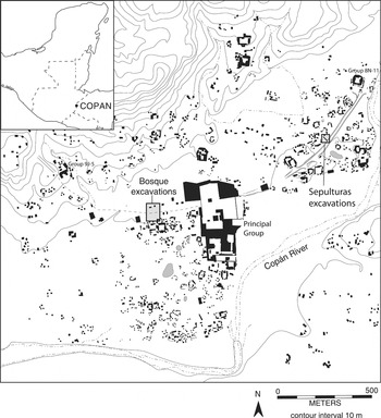
Although the natural setting does not, in and of itself, necessitate drainage and flood control, it created a backdrop against which cultural factors, such as population density, site planning, and architectural design, encouraged water management. First, the majority of the pre-Hispanic inhabitants of Copan, which had an estimated peak population of 20,000 during the Late Classic period (c. a.d. 600–900), occupied the northern lower alluvial terrace (Fash 2001:154). This “urban core” includes the civic-ceremonial center of the city, or Principal Group, and the surrounding residential areas to the east and west of the Principal Group (Figure 1; Sanders 1981). Thus, both sociopolitical and domestic activities would have been affected by the meandering of the Copan River and the flow of its tributaries. Indeed, before consolidation of its northern bank at the end of the nineteenth century, the river had destroyed a significant portion of the eastern part of the city in the millennium following the site's abandonment in the tenth century (Fash 2001:44).

Plan map of the urban core of Copan.
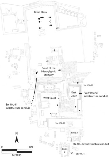
Second, the Principal Group consisted of large, open, paved spaces (i.e., the Great Plaza and the Court of the Hieroglyphic Stairway) and, on the summit of the Acropolis, enclosed courtyards (i.e., the East and West Courts; Figure 2). In fact, the East Court is almost totally enclosed by a series of bleacher-like steps. Therefore, the potential for collecting large quantities of rainfall on the paved and enclosed areas of the civic-ceremonial center was significant and posed a risk to the architectural stability of the mud-mortared temple-pyramids. It is important to note, though, that water collection may have been an important function of civic-ceremonial plazas used during politico-ritual performances (Fash 2005:116; Schele and Miller 1986). Drains could have been blocked to fill up plazas during rainstorms and reopened to release water as desired.

Plan map of the Principal Group, indicating the locations of conduits and structures mentioned in the text.
Finally, the urban wards of El Bosque and Las Sepulturas were densely populated by people of elite and nonelite status during the Late Classic period (Fash 1983a; Fash and Long 1983; Willey and Leventhal 1979; Willey et al. 1978). The potential health hazards caused by a large population living in a compact, water-rich environment without any known sewage system would have been high if water was left to pool and stagnate.
The combination of natural and cultural features at Copan—a major perennial river, several intermittent and perennial streams, and high seasonal precipitation, as well as high population density, expansive paved areas, and significant stone architecture concentrated on the alluvial terraces—would have necessitated investment in drainage and flood control during the Late Classic period to maintain a habitable urban environment. This need was addressed at Copan through the construction of several different types of water-control features, including substructure conduits, subterranean conduits, stucco channels, paved patios, roof drains, splashboards, and elevated causeways (Davis-Salazar 2001).
Substructure Conduits
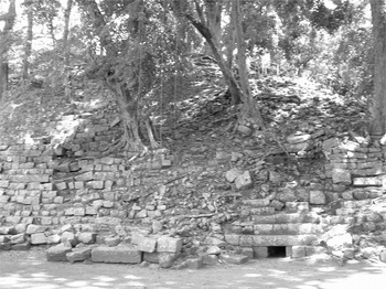
Substructure conduits are stone-lined features that drained semi-enclosed courtyard areas by flushing water through pyramidal bases and out the back side of structures. Two extant examples, the Structure 10L-11 drain and the East Court drain, remain in use today. The Structure 10L-11 drain is a large conduit that passes through the northwestern corner of the pyramidal base of the structure (Figures 2–3). This drain continues to empty the entire Great Plaza and Plaza of the Hieroglyphic Stairway today, as it did more than 1,000 years ago. The conduit is constructed of dressed blocks of volcanic tuff characteristic of the civic-ceremonial architecture of the Acropolis and would have been planned with the final phase construction of Structure 10L-11. Its aperture measures .64 m wide by .5 m high. Its estimated length beneath the pyramid is 40 m, and it continues for at least another 15 m southwest after exiting the structure. Nine meters after exiting the substructure, the construction material changes to small, cut blocks of volcanic tuff, which may or may not be contemporary in origin. Today, discharge from the conduit heads off in a southwesterly direction into the urban ward of El Bosque.

Inlet of the Structure 10L-11 substructure conduit (bottom right corner).
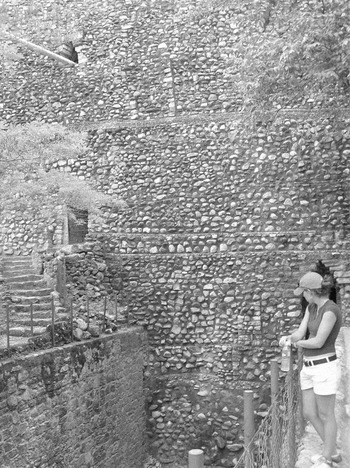
Another large substructure conduit, running under the now destroyed Structure 10L-20, drains the East Court (Figures 2, 4). It exits east off the sheer vertical face of the archaeological cut of the Acropolis, thus earning its nickname “La Ventana” (The Window). Undoubtedly, water running through this conduit and others for more than 1,000 years contributed to the substantial erosion and partial destruction of the east side of the Acropolis and may have even altered the course of the Copan River (Fash 2005:137). The drain opening measures .8 m wide at the base and 1 m high. Although constructed of dressed blocks of volcanic tuff, this drain differs significantly from the Structure 10L-11 drain in that the roof of the East Court drain is vaulted with four courses of dressed stone, suggesting the need for more structural integrity or a desire for a more aesthetically pleasing appearance.
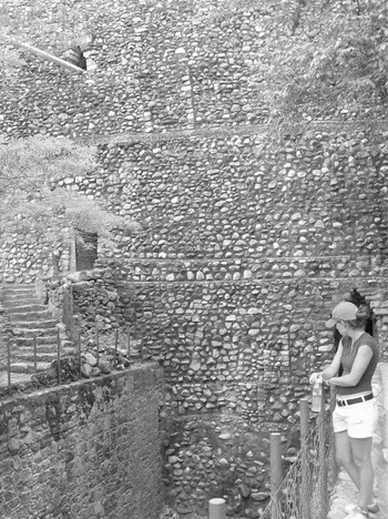
Outlet of the East Court substructure conduit (upper left corner) as exposed in the archaeological cut of the Acropolis (note protruding PVC pipe used to drain the East Court today).
Another notable example of a substructure drain comes from Group 10L-2 south of the Acropolis. The stucco patio (Patio A) of Structures 10L-30 through 10L-33 emptied runoff into a substructure conduit passing through the base of Structure 10L-32, believed to have been the royal palace of Ruler 16, Yax Pahsaj Chan Yopat (Figure 2; Andrews and Fash 1992). This drain measures .4 m wide and .5 m high and was constructed of two courses of dressed stone. A small substructure conduit, measuring .3 m wide, .4 m high, and .65 m long, also drained Patio B of Group 9N-8 in Las Sepulturas (Hendon et al. 1990:139).
Importantly, all four examples described here were constructed of dressed stone and were integral components of civic-ceremonial or elite residential architecture. There are no known Late Classic substructure drains constructed of river cobbles or associated with nonelite architecture. This may indicate unequal access to the technology, materials, and/or labor required for the construction of this kind of water-control feature.
Subterranean Conduits
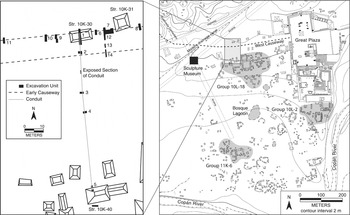
Subterranean conduits are stone-lined features of variable construction that conduct water below ground. Two long subterranean conduits have been identified outside the Acropolis of Copan. Both conduits are located due south of intermittent streams running from the foothills in the area of El Bosque. One runs north to south approximately 300 m west of the radial pyramid in the center of the Great Plaza (Figure 5). The conduit passes underneath the west causeway and heads toward the urban ward of El Bosque. Today, a small section of this conduit remains exposed as it exits from beneath the causeway just south of Structure 10K-30. It is made of cut volcanic tuff and is covered with capstones. Referred to here as the Bosque conduit, the details of this conduit are described more below.

Plan map of El Bosque with a close-up of the area of excavation.
The other subterranean conduit runs parallel to, and approximately 200 m due west of, the one just described. It was discovered in 1992 during reconnaissance excavations conducted in preparation for the construction of the Copan Sculpture Museum, which now buries it (Davis-Salazar 1992). It measures at least 37.5 m in length and was likely used to control runoff from Quebrada Comedero. Like the Bosque conduit, this conduit is constructed of cut volcanic tuff. The sidewalls are three courses high, measuring approximately .4 m tall and set .4 m apart. Removal of a portion of the east sidewall of the conduit revealed a line of small river cobbles likely used before construction to demarcate the intended course of the conduit. In the interior of the conduit several human bones were found, including four poorly preserved crania, three of which were placed in a row across the width of the conduit. Their burial may account for the fact that capstones were not found in this section of the conduit. Scattered human remains were also found outside the conduit .5 m to the east. Importantly, with the exception of the Structure 10L-11 substructure conduit, which turns into a subterranean conduit after clearing the pyramidal base, no subterranean conduits dating to the Late Classic period have been identified in the Principal Group of Copan yet.
Smaller and shorter (in length) subterranean conduits have been identified in Group 10L-2 south of the Principal Group (Andrews and Bill 2005:272, 284) and Group 9N-8 in Las Sepulturas. One of the 10L-2 drains directed water into a large, crude walled channel northeast of Patio B, which then directed water away from residences, east toward the river (Andrews and Bill 2005:284, Figure 7.1). The other 10L-2 subterranean conduit drained Patio B at its southwestern corner (Andrews and Bill 2005:272). The Group 9N-8 subterranean conduit is visible today at the northwestern corner of the southernmost elite patio group (Patio A).
Stucco Channels
Stucco channels tend to be surficial and thus differ from substructure and subterranean conduits not only in construction material but also, to a certain extent, in function. Because of the material with which they were constructed, stucco channels could be added, modified, or removed with minimal effort and therefore were likely good for resolving small, immediate drainage and erosion problems. To date, one such stucco channel has been identified. It ran around the northwestern corner of Structure 10L-41 in Group 10L-2 and directed water into Patio B (E. Wyllys Andrews V, personal communications 1994, 2006), which itself was drained by a stone-lined subterranean conduit (mentioned earlier) at the patio's southwestern corner (Andrews and Bill 2005:272). The 10L-2 stucco channel likely impeded erosion of Structure 10L-41. The ease with which stucco channels could be built could result in networks of channels and stone-lined drains, necessitating some degree of cooperation between patio groups for rainfall runoff to flow from one group into the other.
Paved Patios
Although stucco and stone patios, plazas, and other exterior floors are found throughout the city, their importance as water-control features should not be overlooked (see Scarborough 1993, 1996). Their slightly sloped, smooth, and (semi-)impermeable surfaces directed water into substructure conduits or through openings in patio groups. By their very nature, patios unify several households into one group and thus catch and direct runoff from several structures. The planning, construction, and maintenance of this type of feature therefore would have required participation and cooperation by the residents of a single patio group.
Roof Drains
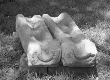
Roof drains are long (.5 m–2 m), sculpted, U-shaped, stone features tenoned off the vertical face of masonry superstructures (Figure 6). These features were designed specifically to manage runoff from the roofs of individual buildings. The channels of roof drains at Copan range from approximately .4 m to .9 m deep and .7 m to 1.1 m wide. One advantage to roof drains was that they directed water away from building walls and thus protected stucco plastering and/or sculpture adorning exteriors. The use of roof drains in elite and civic-ceremonial architecture was ubiquitous, as they have been found all over the site.

Roof drains found in the Principal Group.
Evidence of the incorporation of roof drains into sculptural and architectural facades has been uncovered in tunnel excavations of the Acropolis. Indigo Structure, an antecedent to Structure 10L-22 in the East Court, has a tenoned roof drain centered below a large, painted, stucco mask interpreted as a witz (hill or mountain) monster (Fash 2005:116–117, Figure 4.1). The drain is positioned in the lower register of the building, which would suggest an internal canal descending from the roof or an upper terrace floor. In addition, its location beneath the mouth of the monster suggests that roof drains may have been integral to the architectural and iconographic programs of elite residences, as well (Fash 2005). The examples shown in Figure 6, which incorporate glyphs at the water exit point, reinforce this idea.
Splashboards
Splashboards worked in conjunction with roof drains. They are large, unworked slabs of limestone that reduced the degree of erosion caused by the discharge of roof drains. Two splashboards were found in situ behind Structure 9N-82 of Group 9N-8 in Las Sepulturas, indicating that this building had at least two roof drains (William L. Fash, personal communication 1998). Other splashboards have been found in back of Structures 10L-32 and 10L-29, and one was found at the northwestern corner of Structure 10L-22 in the Acropolis (Barbara W. Fash and William L. Fash, personal communication 2001). The function of these features as splashboards is often overlooked, and they can even be mistaken for burial or cache markers. Their most distinguishing feature at Copan is that they tend to be made of limestone rather than volcanic tuff, which is characteristic of other Late Classic construction.
Causeways
Copan's two causeways also served water-control functions, as the excavations reported later indicate. The causeways extend out in both directions from the Great Plaza of the Principal Group. The east causeway extends 1 km east-northeast to the urban ward of Las Sepulturas, terminating at Group 8N-11. The west causeway extends 1 km west-northwest to Group 9J-5, and terminates at the base of Cerro Chino, an ancient alluvial fan (Fash 1983b; Fash and Long 1983). Thus, as at other lowland Maya sites (e.g., Scarborough 1993, 1996), the causeways functioned as communication routes between the Principal Group and outlying settlements and as water retention/diversion devices.
ARCHAEOLOGICAL INVESTIGATION OF WATER-CONTROL FEATURES IN EL BOSQUE AND LAS SEPULTURAS
The Late Classic inhabitants of Copan employed a variety of water-control features to manage rainfall runoff and stream flow throughout the urban center. Differences in the kinds of techniques used are evident between the civic-ceremonial center, which appears to have employed substructure drains, paved patios, and roof drains exclusively, and the urban residential areas, which employed all types of water-control features found at Copan. Differences in the construction materials and methods are also evident between the civic-ceremonial center, where water-management features were constructed exclusively of dressed stone, and the urban wards, where construction was much more variable. This variation suggests differences in the organization of water management between the civic-ceremonial center, which was presumably under the control of the state, and the urban wards, which were likely (semi-)autonomous sociopolitical units. Several water-control features in the urban wards of El Bosque and Las Sepulturas, therefore, were excavated to investigate technological differences between these residential areas as a means of exploring organizational variation in water management. The underlying assumption is that, because it involves decision making during planning, construction, maintenance, and use, water management may reflect the differing values and priorities of those individuals or groups making decisions (Davis-Salazar 2003). Investigating the physical manifestations of those decisions (e.g., construction materials and methods) provides a way to explore the social dimensions of water management. George Byron Gordon's observation from more than 100 years ago suggests that even seemingly mundane tasks, such as drainage and flood control, cannot be explained necessarily in terms of “practical” solutions to ecological challenges:
The drainage of this city [Copan] and how it was accomplished presents itself as an interesting subject for investigation…. All the level places have regular and continuous slope in some direction, generally towards the south, sufficient to throw off the water, but in some cases it would be thrown into the very places where it would be least desirable to have it. (from the personal notes of George Byron Gordon 1892–1893)
The sociocultural implications of drainage and flood control therefore merit consideration.
The excavations (Operation 4, Suboperation 180) described later focused on conduits and causeways. The specific objectives of the excavations were (1) to document construction techniques; (2) to establish the chronology of construction, use, and termination; and (3) to document associated cultural and architectural features. The sampling strategy was purposive; specific features were excavated because they had been identified previously and, due to their locations, were likely related functionally to one another.
El Bosque
Situated on the low river terrace north of the Copan River, El Bosque is subjected to the southerly flow of mountain streams and seasonal runoff. Two quebradas (small or intermittent streams) in particular—the Comedero and the other unnamed—head southward directly toward this ward and the river farther to the south. This situation creates water-management concerns today. Formerly, a modern ditch running northeast to southwest parallel to the northern foothills captured water and diverted it away from the area to prevent the flooding and erosion of a modern airstrip, as well as of agricultural fields farther to the west (see Figure 5). With the construction of the Copan Sculpture Museum on the abandoned airstrip in 1993, the ditch was replaced by a massive, stone-lined canal. The new canal follows the same path, diverting runoff around the museum, thereby protecting it and the archaeological zone.
The distribution of residential groups and structures in El Bosque suggests that the same flooding and erosion problems may have also affected pre-Hispanic settlement. Swaths of “open” land are visible in the ward, perhaps indicating that the quebradas to the north cut through the ward, washing away any architecture in their path to the river. Whether these were natural stream courses or the result of measures taken by ancient Copanecos to control the flow of water is still unclear, but water-control features were employed in some capacity in El Bosque in antiquity, as they are today.
Skirting the north side of Group 10L-18 of El Bosque, the west causeway stretches 1 km from the Great Plaza to Group 9J-5 where it terminates at the base of Cerro Chino in the northern foothills. With only six isolated structures aligning its north side, the causeway, in effect, creates a northern boundary of urban settlement west of the Principal Group. This arrangement differs markedly from the east causeway, which passes through the middle of Las Sepulturas. Given the water control function of elevated causeways at other Maya sites (Scarborough 1993), and in light of the hydrological situation at Copan that even today requires a massive diversion canal to prevent flooding of the archaeological zone, the concentration of structures south, i.e., downstream, of the causeway may be the result of hydrologically oriented site planning.
Bosque Subterranean Conduit
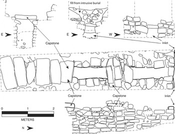
As mentioned earlier, a small section of a subterranean conduit remains exposed today in the urban ward of El Bosque along the main path to the archaeological park. Excavations revealed that the conduit is a subterranean feature measuring 87 m in length, with a southerly slope of .014 degrees. It is constructed primarily of cut volcanic tuff, occasionally substituted by river cobbles (Figure 7). Capstones also made of volcanic tuff covered the conduit for the length of its course, although differences in how the capstones were worked are apparent. Toward the inlet of the conduit, the capstones consisted of extremely heavy, river-worn, shaped slabs of tuff. The remaining capstones, however, were long, narrow cut blocks of tuff with sharp edges. The differences in capstones may be temporally related, with the larger, shaped capstones toward the head of the conduit being earlier than the rectangular, cut ones found toward the southern (later?) half of the conduit. In any event, the ceramics indicate a Late Classic (Coner-phase) date for construction.

El Bosque subterranean conduit (Excavation Unit 1) in cross-section (above), in plan (middle), and in profile (below).
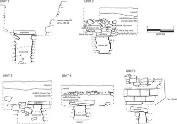
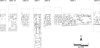
The lateral walls of the conduit varied from excavation unit to excavation unit in terms of their height and number of courses (Figure 8). Most of this variation was found at the beginning of the conduit, where its channel quickly deepened from two courses (.40 m high) to nine courses (1.1 m high), possibly to accommodate the influx of water or to increase its speed of entry. By 30 m along the length of the conduit, the lateral walls evened out to three courses, averaging .45 m in height. The interior width of the channel was consistent, measuring an average of .45 m. The construction material of the base of the conduit was variable, alternatively composed of smooth limestone, stucco, or simply packed earth. Nevertheless, water entering the unobstructed channel would have passed quickly and easily through it, as our excavation units, flooded by daily rains, attested to the impermeability of the channel. The stratigraphy in the interior of the channel consisted of sediment accumulated over centuries of disuse of the conduit.

El Bosque subterranean conduit in cross-section (Excavation Units 1–5).
The inlet of the conduit was built into a masonry wall measuring approximately .65 m in height. The wall was composed of two courses of small blocks of volcanic tuff placed on top of two courses of larger, heavier cuts, including corner stones that were set .4 m apart to form the inlet. The wall into which the inlet was built was discovered to be the north facade of an earlier version of the west causeway. The inlet and small segment of the earlier causeway were buried with the construction of Structure 10K-30. The functional relationship between the conduit and causeway and significance of Structure 10K-30 are treated in more detail later.
The outlet of the conduit was buried by Structure 10K-40, a large elite building of Group 10L-18 measuring more than 4 m in height. As a result, the intended destination of the diverted water is unclear, but there are at least two possibilities. First, the conduit diverted water into what was once an open, unoccupied area adjacent to what is likely the original core of residences making up Group 10L-18. The westward expansion of this group would have resulted in the cancellation of the conduit. Second, taking into account the Maya tradition of superimposed construction, there may have been earlier phases of Group 10L-18 that coexisted with the conduit, in which case the conduit may have flushed water into a courtyard. This raises interesting questions about additional functions of the conduit. Further investigation is needed. In any event, test units verified that the conduit did not continue south past Structure 10K-40; therefore, it is not likely that the conduit was intended to replenish the Bosque laguna that is located roughly 250 m to the south. Excavation of the Bosque laguna further confirmed this (Davis-Salazar 2003:285–286).
The relationship between the conduit, Structure 10K-30, and Structure 10K-40 is of some interest. While it is not yet clear which structure was erected first, the construction of either would have immediately terminated use of the conduit. The construction of Structure 10K-40 on top of the outlet of the conduit is likely related to the growth of that residential group. In comparison, the construction of Structure 10K-30 above the inlet appears more deliberate. Structure 10K-30, a small, isolated mound, was erected directly on top of the head of the conduit, oriented so that the inlet was located in the center of the building. An interment associated with Structure 10K-30 resulted in a gap in the two upper courses of the north facade of the causeway just above the conduit opening. Scattered remains of human bone, including skull and long-bone fragments, were found outside the mouth of the conduit, some resting on the first capstone. The placement of Structure 10K-30 may be a coincidence or a convenient and efficient method of terminating the use of the conduit. It could also point to a symbolic termination of the water feature, as has been documented elsewhere (Kolata 1993; Walker and MaGahee 2001). Given that human remains were found in another long subterranean conduit at Copan, the latter interpretation is plausible.
West Causeway
Excavation of the conduit revealed an earlier construction phase of the west causeway, which also dated to the Late Classic (Coner-phase) period based on ceramics found in the construction fill. The earlier west causeway consisted of a white stucco pavement bordered on the north side by a masonry parapet. The causeway, excluding parapet, measured approximately 9.3 m wide. The parapet, constructed of cut stone, measured an average of 1.6 m wide and minimally .85 m high (Figure 9). Near the Great Plaza, the causeway was constructed by laying gravel ballast on the ground surface and then plastering over it with stucco. As one moves west, however, the natural ground surface decreases in elevation due to natural drainage patterns. To maintain a level surface and raise the walkway above potential flood areas, the causeway was built up with fill and retained, at least on the north side, by a masonry wall. This is evident in the increasing height and number of courses of the north masonry wall of the causeway as one moves from east to west. Along the 70 m stretch of the north facade that was excavated, the height of the causeway foundation increased from ground level in the easternmost test pit to .85 m (5 courses) in the westernmost. The total height of the north side of the causeway, including parapet, was minimally 1.7 m in some sections. Thus, the masonry wall created by the causeway foundation and parapet would have been effective at retaining and diverting the southerly flow of stream discharge and rainfall runoff. Certainly, the parapet would have prevented water from washing onto the causeway near the Great Plaza where the causeway pavement was laid at ground level. The north masonry facade of the causeway, capped by a parapet, was significantly more formal than the southern edge of the causeway, where the ballast feathered out.

Plan view of the parapet of the early west causeway in El Bosque.
The length and destination of the early causeway is as yet unknown. With later constructions and what appears to have been a massive leveling project of the area represented by a thick layer of reddish brown clay found throughout the excavations, several courses of the parapet were dismantled, and the entire construction was buried. Use of the early causeway therefore was terminated and replaced with the final causeway, which followed the same path as the early causeway, shifted only slightly to the south. Structures 10K-30, 10K-31, and the three other structures that edge the final version of the causeway rest on top of the northern limit of the earlier causeway.
In summary, in El Bosque, topography and hydrology appear to have been determining factors in the construction of the early west causeway. Toward the Great Plaza, the causeway appears to have been built on terra firma. However, as the causeway extended westward, the level of the walking surface was raised to compensate for the gradual decrease in elevation of the natural terrain. The result was an increasingly tall masonry facade crosscutting depressions in the natural terrain. Such a construction would have impeded the natural, southerly flow of water and thus protected the residential area to the south from flooding and sedimentation. At least one subterranean culvert was built into the causeway to divert water under the walkway and thus prevent flooding on the north side. Other culverts, such as the one found in 1992, were likely used along the length of the causeway.
Las Sepulturas
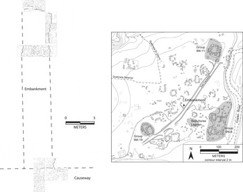
The urban ward of Las Sepulturas is an elite residential area located 1 km east of the Principal Group. Bound on the west by the Principal Group, on the north by the rising foothills, and on the east and south by the Copan River, the ward formed a spatially discrete community (Figure 10). Formal access to the community could be gained from a causeway that extends 1 km from the Great Plaza to Group 8N-11 of Las Sepulturas. Residences cluster in household groups along most of its length, save for a short segment adjacent to the Principal Group where the Quebrada Salamar may have destroyed evidence of habitation or simply precluded it.

Plan map of Las Sepulturas with the east causeway and embankment.
As in El Bosque, a large laguna is located in the southeastern half of the Sepulturas ward, just off the north side of the causeway. Local informants say that, in the past, there may have been as many as three lagunas in Las Sepulturas. One of the older workmen with whom I excavated remembered that the lagoons were in existence until the 1940s. Surrounded by large ceibas, other tall trees, and much vegetation, the lagunas were shaded and wet year-round, according to his recollection. The extensive cultivation of the area over the past few decades, which resulted in the denuding of the landscape, may have caused their desiccation. As with the Bosque laguna, the Sepulturas laguna was likely a communally managed source of potable water and site of ritual activity (Davis-Salazar 2003).
Today the quebradas Chorro and Salamar descend from the northern foothills and converge just northwest of the causeway. During the rainy season, their discharge enters Las Sepulturas from the northwest, crosses the causeway, passes through the Sepulturas laguna, and exits the ward southwest of Group 9N-8. I find it likely that at some point in the past, Quebrada Salamar continued in a straighter (more southerly) path toward the river rather than joining Quebrada Chorro. The lack of structures to the northeast of the Principal Group, in addition to the fact that a portion of the east causeway in this same area has been destroyed, suggests that Quebrada Salamar may have passed through there at one time. The idea that the quebrada may once have flowed in a more direct path to the river is supported by the fact that much of the area has silted in. There were a number of structures there, but they have since been deeply buried (Fash 1983a:Appendix A).
Located just southeast of the point of convergence of the two quebradas, a long, narrow platform abuts the northern edge of the east causeway. The function of the platform was unclear due to its unusual shape, which is unlike most other structures in Copan. The long, range-like form of the platform suggested that it was not residential in nature despite its location in the urban ward. It was possible that, due to its position in reference to the southeasterly stream flow of the springs, the platform, in conjunction with the causeway, served a water-control function. Interestingly, when indicating the location of the now desiccated lagunas, the workman gestured toward the area of the platform and causeway. Excavations in Las Sepulturas focused on this junction between platform and causeway.
East Causeway and Sepulturas Embankment
The east causeway is an elevated construction made of small- and medium-size river cobbles set in a brown clayey fill. Cut stones do not appear to have been used in its construction—at least, not in the section excavated. The causeway itself measures roughly 10 m wide and stands an average of .5 m high (Fash 1983a). As it passes by the laguna, the height of the walkway increases to approximately .8 m. At this same point, a cobble platform or embankment abuts the northeastern side of the causeway.
The cobble embankment measures 4.45 m wide and 25 m long. It is constructed of unmodified river cobbles set in a dark brown clayey fill. The walls consist of two to three courses of medium-size to large cobbles, giving it an approximate height of .6 m. Thus, one would step down .2 m from the causeway off two large flat stones and onto the embankment. Attached to the northern end of the cobble embankment is a masonry platform. The walls of the masonry platform consist of two to three courses of small cut blocks of volcanic tuff. A low cobblestone floor surrounds the masonry platform. The masonry platform maintains the same width as the cobble embankment (4.5 m) and measures just under 3 m long, bringing the total length of the entire construction to approximately 28 m.
The ceramic data indicate that both the cobble embankment and the causeway date to the Late Classic (Coner-phase) period, as does the masonry platform at the north end of the embankment. It appears that the construction of the cobble embankment postdates the construction of the causeway and predates the masonry platform; the embankment was tacked onto the causeway, and the masonry platform was then tacked onto the embankment.
On the east side of the cobble embankment, a thick bed of black clay indicates that the area was subjected to periods of inundation. The black clay on the east side contrasts sharply with the brown, sandy soil found on the west side of the embankment. No other water-management features were identified through excavation in this area. Rather than being diverted under the causeway by means of a subterranean canal, runoff and stream discharge appear to have been retained behind the elevated causeway and the cobble embankment. Water collected there would have had no means of drainage.
As in El Bosque, the causeway and embankment in Las Sepulturas likely served to impede the southeasterly flow of water. During the rainy season, discharge from the Quebradas Chorro and Salamar passes through the ward of Las Sepulturas. Whether or not the quebradas converged in antiquity as they do today remains to be confirmed, but if left unchecked, runoff from the foothills likely would have inundated the heavily populated urban ward. The elevated causeway would have minimized the risk of flooding and sedimentation throughout most of the southeastern half of the urban ward, while the short, elevated embankment likely impeded the southwesterly flow (i.e., toward the elite Group 9M-19). Whether this was merely to protect residences and the laguna to the south from flooding or to collect water is still unclear. However, unlike in El Bosque, the lack of drainage at the critical junction between the causeway and embankment suggests that there was no means of escape for rainfall and stream flow. This is supported by the stratigraphy, which indicates the presence of stagnant water. Here it is also important to note that no evidence was found to indicate a domestic use of the embankment, which is in keeping with its unusual form.
SOCIAL IMPLICATIONS OF WATER CONTROL AT COPAN
The urban wards of El Bosque and Las Sepulturas provide an interesting point of comparison for considering the social implications of water control. Both areas are elite residential zones located adjacent to the Principal Group. Each is connected to the Principal Group via an elevated causeway, and each is associated with a large laguna. There are, however, significant differences between water-control techniques and construction materials used in El Bosque and those used in Las Sepulturas. These differences appear to be a result of sociocultural decisions rather than responses to different hydrological situations. For example, the use of cut stone for the subterranean culverts and the early west causeway in El Bosque is interesting when juxtaposed with the cruder, cobble-and-earth fill of the east causeway and associated embankment. This difference may be a function of time (while both are Late Classic constructions, the earlier version of the west causeway may not be contemporaneous with the east causeway) or space (the west causeway was excavated only meters from the Great Plaza; the east causeway was almost a kilometer away in a residential zone).
Alternatively, differences in construction material may have to do with differing functions of the two causeways. In addition to creating a level walking surface, which was built by filling in depressions on a variable terrain, the west causeway functioned to check and drain runoff. The more formal construction of this causeway in the vicinity of the Principal Group permitted the incorporation of subterranean conduits on its north facade. In contrast, the function of the east causeway appears to have been to retain and collect water, in addition to creating a level walking surface. By building up cobbles and earth, the Late Classic Copanecos also constructed a sturdy embankment and raised the walkway above inundated terrain.
The reason for the functional differences between the causeways may have to do with their paths through these urban wards. The west causeway appears to skirt the north side of major residential groups. Only six structures border its northern edge, while several groups are located due south (although, it is possible that post-abandonment colluviation has obscured our ability to see more structures that originally could have occupied the area north of the causeway or that construction of a now abandoned airstrip destroyed any structures in this area). In contrast, the east causeway bisects Las Sepulturas, creating a spatial division between north and south groups. Such a division would have left those on the south side with easier access to the Sepulturas laguna than those on the north side. The embankment jutting off the north side of the east causeway may have been an attempt to create or enhance a small water source on the north side of the causeway.
Perhaps the most intriguing question is why the water-control function of the early west causeway in El Bosque was seemingly eliminated with the construction of its final version. One possibility is that the extensive backfill program west of the Principal Group negated the need for water-control features in that particular area, and/or new water-control features were constructed farther north. Another possibility is that a change in hydrology in this area rendered the causeway and associated culverts unnecessary, allowing the areas north of the causeway to be occupied. A third alternative is that the residential groups in El Bosque, which the early causeway was designed to protect, had developed their own water-management techniques (such as stucco channels) that allowed them to attend to concerns and problems specific to their hydrological situation. The answers to these specific questions require more investigation, particularly geomorphologic analyses of the pre-Hispanic landscape of the Copan Valley.
However, it can be stated that little standardization in water control existed between the two urban wards and between the wards and the civic-ceremonial center. Not only is the distribution of features across the site not uniform (in the civic-ceremonial center, substructure drains, paved patios, and roof drains appear to have been used exclusively, while outside the civic-ceremonial center, all types of water-control features are found), but also the same types of water-control features show variable construction materials and methods. The suggested implication of this is that different decision-making mechanisms may have been employed when planning and constructing water-control features in the residential wards.
The idea that variation in water-control techniques and construction suggests different organization of water management between the two urban wards of Copan and between the wards and the civic-ceremonial center is underscored when compared with evidence for water control at Palenque. There (French 2002), a fairly standard solution—the use of well-constructed aqueducts, drains, and walled channels—was applied to a similar problem (flowing water through occupied areas) throughout the urban center. This standardized response suggests some degree of centralized control, likely by the state, and is more comparable to water control in the civic-ceremonial center of Copan.
In summary, at Copan, causeways checked flooding and erosion, protecting residences in the south part of the city. Stone-lined conduits passed runoff under the causeways as well as through the interior of pyramidal bases. Sloping, paved plazas captured rainfall cascading down structures and shooting off roof drains, diverting it to subterranean drains and shallow, stucco channels, which then guided the water among residences and other plazas. Stone splashboards positioned below roof drains minimized erosion around buildings. Not only the types of water-control devices used but also the construction materials and methods varied between the two urban residential wards of Copan and between the wards and the civic-ceremonial center, where water-control features were well-constructed, integral components of the civic-ceremonial architecture. This variability suggests more diffuse control in water-management tasks within Copan as well as between Copan and Palenque. Water management for drainage and flood control was an important aspect of daily life in Copan and elsewhere in the Maya area, which should be investigated further.
RESUMEN
Investigaciones recientes sobre el manejo del agua en la Mesoamérica prehispánica han revelado una diversidad de sistemas adaptivos empleados en las Tierras Bajas Mayas. Como muchas de estas investigaciones se han enfocado en el manejo del agua para el consumo humano y la agricultura, otras formas de manejo del agua, como el drenaje y el control de inundaciones, no se han investigado extensivamente. Este informe describe varias técnicas para el control del agua dedicadas al drenaje y al control de inundaciones durante el clásico tardío (d.C. 600–900) del sitio de Copan, Honduras. Este informe pretende también investigar las implicaciones sociales de esta forma de manejo del agua. Los componentes del drenaje y el control de inundaciones incluían desagües bajo estructuras, desagües subterráneos, zanjas y plazas de estuco, desagües de techo, tablas para prevenir la erosión, y calzadas. Las calzadas detenían las inundaciones y evitaban la erosión, protegiendo así las residencias en la parte sur de la ciudad. Los desagües, hechos de mampostería, pasaban agua bajo las calzadas y también por el interior de las bases piramidales de las estructuras. Las plazas pavimentadas colectaban la lluvia que caía de las estructuras y los desagües de techo, desviándola hacia las zanjas de estuco, las cuales a su vez dirigían las mismas hacia las residencias y otras plazas. Las tablas hechas de piedra que se ubicaban bajo los desagües de techo minimizaban la erosión alrededor de las estructuras. Tanto los tipos de aparatos para controlar el agua como también los materiales y métodos de construcción variaban entre los dos barrios habitacionales urbanos de Copan y a su vez, entre los barrios y el centro cívico ceremonial, donde rasgos del manejo del agua eran componentes integrales y cuidadosamente construidos de la arquitectura cívico ceremonial. Esta variabilidad sugiere un control difuso en el manejo del agua en Copan. Comparaciones con Palenque, el otro centro maya donde se han investigado el drenaje y el control de inundaciones, apoyan la idea de que el manejo del agua en Copan fuera uno organizado diferentemente a través de este centro urbano.
ACKNOWLEDGMENTS
This work was conducted with the permission and assistance of the Instituto Hondureño de Antropología e Historia. I gratefully acknowledge the aid of Oscar Cruz, Carmen Julia Fajardo, and Olga Joya of that institution. Financial support for excavation was provided by the Department of Anthropology at Northern Illinois University, and for data analysis and write-up by the Department of Anthropology at Harvard University, Dumbarton Oaks Research Library and Collections, the Ford Foundation, and the Mellon Foundation. Final revisions of this article were undertaken with the support of the Department of Anthropology at the University of South Florida. I am especially grateful to Barbara Fash, William Fash, and Christian Wells for their intellectual and editorial contributions to this paper. I also thank Scott Fedick and Vernon Scarborough for their thoughtful reviews of a draft of this manuscript. Any and all errors are my own.