HISTORY OF INTERVENTIONS
The site was first discovered in 1783Footnote 4 and subsequent work there has been summarised well by David Wilson in his guides and publications of the site.Footnote 5 The first major investigations were in 1813–17 when the villa was excavated by the Rector at nearby Hanborough, Walter Brown, and the architect Henry Hakewill.Footnote 6 At least five third-century mosaics were revealed, though after two had been destroyed by souvenir hunters, the landowner, the Duke of Marlborough, commissioned a shed to protect the remaining ones; complemented later with a custodian's cottage to secure the site.Footnote 7
Twentieth-century investigations began in 1910–11 with excavations by Donald Atkinson and Evelyn White, partly observed by Francis Haverfield.Footnote 8 The overall plan of the site was extended with the addition of new buildings from aerial photographs observed by Flight Lieutenant D.N. Riley in 1943.Footnote 9 The chronology was refined during work by Helen O'Neil for the Ministry of Works in 1956–9 which revealed post-holes under the northern range of the villa associated with ‘Belgic ware’.Footnote 10 The site was partly resurveyed in 1973;Footnote 11 and in 1975–7 small-scale excavations by Jeffrey West, Jerome Bertram and Angela Lister took place prior to consolidating some of the remains.Footnote 12 The results were incorporated into the official Department of the Environment 1980 handbook by Wilson.Footnote 13 Since then there has been relatively little work, except for a watching-brief in 1979 in the field between the Roman villa and the river Evenlode by Oxford Archaeology Unit.Footnote 14 A large drainage ditch, cut from the railway bridge corner up to the field boundary and back to the river again, revealed six large masonry walls, which were thought by David Miles to potentially have been part of three buildings.
THE DEVELOPMENT OF THE VILLA
Wilson's work established our current understanding of the overall chronology of the site:
Period 0: Pre-Roman Iron Age pottery and associated features were found by O'Neil under the south-west range of the villa, as well as Rooms 4 and 6 of the north-west range. ‘The pottery was described as Belgic (especially in Rooms 53, 54, and 67), Rhenish (Room 54).’ Residual material in significant quantity was also found under the Period 1 north bath-house.Footnote 15 Collectively this suggests there was fairly extensive pre-villa occupation.
Period 1: The villa itself began in the first or second century as a series of three buildings comprising the north bath-house with two further buildings to the south-west. Over time these were linked together to form one long structure with a linking corridor, which became the north-west range. Wilson identified five sub-phases A–E within this in his interpretation of the development.Footnote 16
Period 2: Later, the north-west range was totally rebuilt, with the Period 1 remains demolished and used only as foundations. Early in the third century (our chronology is imprecise) the south-west and north-east wings were added, partially enclosing the courtyard. Wilson observed that the north-east range was ‘constructed over made ground (apparently a filled-in gravel pit), which led to subsidence of walls and floors at the south-west end of Rooms 29 and 30’.Footnote 17 This north-east range included a second bath-house (the ‘East Baths’). The south-west range was interpreted as being given over to ‘workshops and outbuildings’. The range is interpreted as containing a stable (underlying Rooms 53–55) and at the far end a barn (Room 63) into which a bath suite was later added. Separating them was another gravel pit, 3.7 by 15 m, as much as 2.8 m deep. Eventually when a linking corridor was added creating a unified façade to all of these building, special measures were taken to support the walls over this pit. To the south-east a new imposing entrance was constructed. By the end of Period 2 the villa had an appearance of architectural unity which belies its composite history.
At its peak the villa incorporated four bath suites, 16 mosaic floors and 11 rooms with underfloor heating. It was abandoned in the fifth century.
THE SURVEY OBJECTIVES AND METHODOLOGY
While the courtyard villa buildings are impressive enough, it was always supposed there was more surrounding them. John Ward in 1911 had conjectured there might be a lower courtyard on the south-east side of the villa, similar to those found at Bignor and Woodchester.Footnote 18 The drought of 1943 revealed an extension to the south-west of the villa in parchmarks in the field, captured by Riley.Footnote 19 These findings were complemented by other aerial photographs taken by Keith St Joseph in 1957, who conjectured that the potential structure could be an aisled barn or hall. The structure measured c. 32 by 12 m and had a verandah added along the south-east side which appeared to be fronted by a metalled trackway.
Wilson drew together the evidence for his new plan (fig. 1). The chief additions were two ranges of farm buildings flanking a metalled track on much the same alignment as the south-east range of the main courtyard. Also important was the discovery of what appeared to be the south-west extremity of the north-west range of the courtyard, which seemingly projected some way beyond the great dining-room (Room 1) and the already known portions of the south-west range. A south-western enclosure-wall ran outside these new discoveries and up the hill, where it turned to enclose a paddock or walled garden; other markings revealed the presence of drains and foundations of several periods.Footnote 20 One of the conclusions of Wilson's reassessment was that geophysical survey might bring greater precision and detail to the aerial images.
D.R. Wilson's plan of 1977 (redrawn from Wilson Reference Wilson2004, 79).

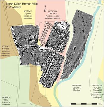
The villa is situated on the edge of the alluvium floodplain of the river Evenlode, sitting on a bed of Northmoor sand and gravels at the base of the limestone slopes. The gradiometry survey, performed using a Bartington 601–2 dual gradiometer system (resolution of 0.25 m by 0.5 m), was conducted in the late spring of 2013 on two sets of dates. Our interpretation has not tried to reinvent the plan of the villa. Significant work has already been undertaken by Wilson based upon extant evidence (and the now lost notebooks of O'Neil) to create a revised plan of the site. This has been digitised and superimposed upon the geophysical results.
RESULTS AND INTERPRETATION (FIGS 2–3)
THE EARLIEST FIELD BOUNDARIES
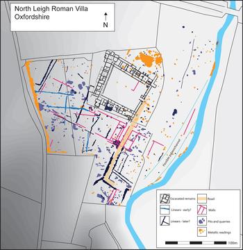
Ellis et al. reported that under Rooms 26A and 26B in the northern corner of the villa, there was a deep feature (F1) running east–west.Footnote 21 This predated the villa but was poorly defined and did not appear on any plans. Given its orientation and early date, it could relate to two other major east–west features seen in the geophysical data: two parallel linears c. 25 m apart, which do not appear otherwise to relate to the layout of the developed villa complex.
Situation of the villa and gradiometry survey relative to the geological deposits (Geological map data © NERC 2012, crown copyright, supplied through EDINA). Gradiometry survey, shown at ± 3 nT (black is +3 nT, white is –3 nT).

Gradiometry interpretation.

THE QUARRIES AND THE CONSTRUCTION OF THE VILLA
During the excavations, a number of large gravel pits were identified from early in the sequence. These were eventually built over by the north-east and south-west ranges. The builders were still clearly aware of them as they took remedial action by initially avoiding these areas and then strengthening the walls.
The south-west range was initially extended as far as Rooms 54–55, fronted by Corridor 60b. The initial extension may have ended there because of the existence of a filled-in gravel pit, which lay just beyond; the end-wall was provided with extra-deep foundations to ensure stability.Footnote 22 The pit was c. 3.7 m wide, 15 m long and 2.8 m deep.Footnote 23 When the south-west range was extended further east, ‘special measures were taken to carry one of the principal walls across the old gravel pit: the north-east wall of Rooms 56 and 59 was reinforced by the provision of substructures to carry its weight over made ground’.Footnote 24 Aerial photography suggested a square room or building south-west of Room 53, but this was not clear in the geophysics, though there was interference from a metal fence at this point so it may have been obscured.
Another gravel pit lay at the eastern end of the north-east range; Rooms 41 and 43 contained subsiding floors, and the north wall was supported by three large rectangular projections.Footnote 25
In addition to these, the geophysics suggested a series of large extraction pits higher up the slope, though here they would have been quarrying into the limestone, rather than gravel. Most are 10–15 m in diameter and semi-circular as they cut into the side of the hill. It is likely that these quarries are associated with the construction of the villa.
REALIGNMENT OF THE LANDSCAPE
A reorganisation of the landscape seems to have taken place as the villa developed into its full courtyard form. A new road was constructed from the axially centred entrance into the complex, leading SSW between the two buildings identified in the aerial photographs. The one to the west of the road showed more clearly on the aerial photographic plots than the gradiometry, while the hall to the east was much more ephemeral. This was also demonstrated by some experimental GPR results (not reproduced here).
Including these southerly ‘halls’, there appears to have been a ditch and a wall bounding the south-western side of the complex. There is a standard positive linear feature (ditch) with a fainter parallel negative feature, which together look like the walls of the buildings. It is quite possible that this wall/bank and ditch run 150 m WNW up the hill from the road, where they turn 90 degrees to form what may be a square enclosure surrounding the entire complex.
The floodplain to the east of the villa is relatively clear. There are signs of an older palaeochannel, suggesting the river has shifted its course over the years, though there is no evidence for dating this occurrence. The palaeochannel does, however, have a fairly straight edge to it, in comparison to its current winding path, as if this might represent canalisation at this point in front of the formal villa structure.
There are slight hints of a building at the southern end of this field, with one of its walls running parallel to the ‘new halls’ to the north-west, but it is decidedly ambiguous. It is possible that this feature relates to the walls identified by David Miles in 1979, but this would mean that the drainage channel cut by the farmer stretched the entire length of the field. Without further details regarding the watching-brief, this will remain uncertain. Otherwise, no other features showed up in the gradiometry results in the floodplain field which might relate to Miles’ observations.
There is, however, a large geomagnetic anomaly axially aligned with the entrance-way, which looks like a large pit, c. 7 by 12 m. Interpretation of this feature is difficult as any excavation here is likely to hit the water-table relatively rapidly. A central shrine or pool associated with the villa is a remote possibility, but the feature could also be entirely unrelated.
The road running to the south takes a sharp staggered turn towards the edge of the survey area. This relates to the topography. The roadway heading south is leading directly towards a steep rise in the land formed by a spur of the valley side. Whether the road continued on the southern side of the bank or forded the fairly shallow stream is not clear, though this is clearly the main access road into the villa.
MODERN METALLIC DISTURBANCE
A great density of metallic noise lay in the long grass within the public-access area, to the west and north of the villa. This correlates with where picnicking takes place and modern debris is likely to be found. The significant noise to the north had no obvious surface explanation, but provides a response similar to spoil heaps on some other surveys. Along the edges of some of the fields the barbed wire fences showed themselves, as did a major utility pipe along the western edge of the survey area parallel to the road.
DISCUSSION
In terms of parallels, North Leigh has been discussed extensively in the standard Roman villa literature among other ‘courtyard villas’ which were formed from the ‘tidying up’ and agglomeration of pre-existing buildings, such as at Bignor,Footnote 26 FishbourneFootnote 27 and Darenth.Footnote 28
In terms of the new features, the large rectangular enclosure surrounding the entire complex has a potential parallel at Brading (IoW) where similar linear features have been revealed by geophysics.Footnote 29 At Bignor (W Sussex), which is of a similar date, size and type to North Leigh, its fourth-century courtyard villa form became enclosed by a large wall which incorporated the extra buildings. Similarly at Bancroft (Bucks.), the mid-fourth- to early fifth-century phase received a large ditched enclosure running externally to what was potentially a courtyard-type complex, and which overlay (reorganised?) a pre-existing villa settlement and field-system.Footnote 30
In terms of the evidence for the surrounding field-system, the area surveyed at North Leigh is still relatively small compared to that at, say, Brading. It is not possible to make sense of all of it, but a reorganisation and re-orientation are clearly apparent. This is unlike some other sites where large-scale surveys have taken place, such as at Dunkirt Barn (Hants.). Here the site developed from a late banjo enclosure into a large winged-corridor villa and garden enclosure, but the fence lines always respected the larger, earlier settlement enclosure.Footnote 31
In terms of the floodplain location of North Leigh villa, there are numerous courtyard villas lying alongside rivers which are easy to pick out (Kent has a few of the higher-status examples). In particular, at Darenth villa, located alongside the river Darent, a large aisled hall structure lay to the south-east of, and external to, the main courtyard enclosure, as did one of its bath-houses.Footnote 32 Fishbourne Palace included Building 3, which was constructed before the palace, but continued in use lying right in front of the main structure, apparently obstructing its view to approaching people, who would have used the metalled trackways running past it into the main palace.Footnote 33 Fishbourne is clearly not contemporary with the final phase at North Leigh but it, along with other examples, shows that courtyard villas were not always isolated buildings lying within ‘open’ landscapes.
The possible canalisation of the adjacent river at North Leigh also has parallels, including Darenth and Fishbourne already mentioned, as well as the villa at Fullerton (Hants.). All three have produced remains of large millstones, with Darenth and Fullerton also including structural evidence which would support the undertaking of milling at the sites, providing a context for the canalising of their respective rivers.Footnote 34 Only with further excavation at North Leigh would this possibility be proven.