

Introduction
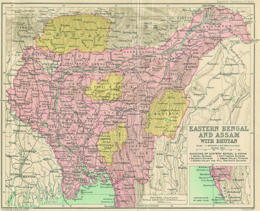
The map of Eastern Bengal and Assam published by the Imperial Gazetteer of India at the turn of the twentieth century shows the spread of colonial rule in the North East Frontier of British India (see Figure 1).Footnote 1 The colour yellow hinders a seamless view of colonial territory and forces the viewer to take note of enclaves that were not directly under colonial rule. The colours on the map that differentiate between territories recognized as British and those considered semi-independent or independent help us see that imperial sovereignty was uneven.Footnote 2 Yet, the map precludes an understanding of the nature of imperial sovereignty that was both spatially and temporally uneven. Time as a scale of progress and space as a concomitant unit for ordering civilizational hierarchies were interrupted throughout the period examined in this article. This article demonstrates the peculiarities of colonial ordering in the Khasi, Jaintia, and Garo Hills between the late eighteenth and late nineteenth centuries and thereby inquires into the nature of interrupted sovereignty. The article asks: What kind of strategies of colonial governance were embedded in juridical determinations of the Frontier space? How are spatio-temporal constructions such as frontier and hill tribal employed as strategies of governance? How do they allow the non-territorial existence and functioning of imperial sovereignty? What do jurisdictional disputes reveal about interruptions to colonial rule and imperial sovereignty?
From the mid-eighteenth century onwards, the Khasi, Jaintia, and Garo Hills in the north-east of British Bengal and part of the larger Himalayan borderland region were transformed into a frontier.Footnote 3 These hills merged imperceptibly into the Sylhet plains and were marked by differentiated colonial legal ordering.Footnote 4 Multiple large and small polities integrated within a network of alliances and rivalry spread across this landscape. New scholarship on the North East Frontier of the British empire in India conceptualized as the Himalayan borderlands compels a critical re-evaluation of the geographical boundaries and imaginaries associated with it. Scholars have pointed towards the necessity for looking outside nation-state boundaries to address historical problems.Footnote 5 Taking cue from this scholarship, the article examines political relations between polities across the Khasi, Jaintia, and Garo Hills and the colonial state. These relationships were contingent and strategic, and cannot be assessed simply in terms of different degrees or distortions of imperial sovereignty.Footnote 6 Formulations of sovereignty structured the relationship between Britain and the colonies, as well as those within the colonies.Footnote 7 Such formulations became manifest in the role of law to secure and expand imperial borders, and in relationships with communities who were outside of Mughal territorial and imperial control.
Legal and geographical reconceptualization of the hills as a frontier of the British empire in India contains historically contingent strategies of governance. Jurisdiction was a prerequisite of sovereignty and remained an important concern before and after the signing of treaties in these frontier hills. Jurisdiction involved law making as boundary making. It entailed the dual process of locating authority and placing limits on it. Disputes around jurisdiction, as this article demonstrates, carry persistent concerns around authority and reveal the interruptions to imperial sovereignty in these frontier hills. Hybrid notions of sovereignty, including a Hobbesian understanding centring on singular sovereign authority, travelled with colonial agents into the Frontier, culminating in treaties and agreements.Footnote 8 The inherent epistemological and ontological diversity of Western notions of sovereignty enabled imperial sovereignty in the Frontier to be ambiguous, imprecise, and strategic. The imprecision and ambiguity were simultaneously responses to the encounter with incommensurable and varied forms of authority and power in this region.
Imperial states since their inception, Lauren Benton has argued, existed in a patchwork, uneven formation with strongholds intersected by autonomous or semi-autonomous zones. Sovereignty was marked by the degree of legal authority the imperial states possessed. Legal authority continued to be plural, spanning centuries and across geographical space, and hence imperial legal sovereignty was always already fragmented, lumpy, and uneven.Footnote 9 Building on this thesis, Eric Lewis Beverley has argued that the frontier of Bombay presidency and the princely state of Hyderabad represents ‘a tangled configuration of fragmented sovereignties’ that could not be completely controlled by the states’ policies. The concept of fragmented sovereignties used by Beverley resonates with Benton's idea of a patchwork of coexisting plural legal orders. Beverley departs from Benton by arguing that being fragmentary was not a stage in the formation of imperial states, but characteristic of imperial frontier zones even in the heyday of empire. Beverley's analysis shows how sovereignty was practised, enforced, evaded, and realized by competing states on the one hand and inhabitants of the frontier zones on the other. The frontier zone, Beverley argues, became a resource for inhabitants of the region to out manoeuvre state authority, patriarchal norms, surveillance, and discipline. The judicial complexity, changing meanings, and differentiated rules enforced in the frontier zone made it a site of both creativity and power.Footnote 10
The Frontier was not simply a creative space due to its fluidity and in-between-ness, as in Beverley's optimistic formulation. Instead, the Frontier allowed the accommodation and proliferation of oppressive and racialized colonial categories of governance.Footnote 11 The fluidity, imprecision, and ambiguity around jurisdictional boundaries were conducive to severe forms of violence.Footnote 12 It is imperative that notions of different degrees of a unified patchwork imperial sovereignty and frontier spaces as enabling creative resistance are not foregrounded to the extent of invisibilizing inherent and transformative violence of imperial sovereignty.
Political legitimacy for the English East India Company (EIC) was derived through charters and sanctions, primary among them the Royal Charter Act and the Right to Diwani.Footnote 13 Treaties defined the relations between the EIC's central government in Bengal, local administrative officers in the North East Frontier, and the headmen, Chiefs, and Rajas identified in the Khasi, Jaintia, and Garo Hills as wielders of indigenous or local sovereignty. Notions of sovereignty that travelled with colonial agents culminating in treaties, agreements, and decrees did not possess the adequate vocabulary to translate or incorporate pre-existing authority and land relations. The Treaty of Yandabo was signed with Burma in 1826 at the conclusion of the first Anglo-Burmese War (1824–26). Assam was integrated into the British empire, but the threat of Burmese interests in Assam and their alliance with the communities and rulers in the region contributed to the precarious commercial and political position of the Company.Footnote 14 Treaties signed in the 1820s and 1830s contracted away the rights of the latter. For instance, the Khasi Syiems, Jaintia Rajah, and head men identified in the Garo Hills were imbued with sovereign status through the signing of treaties, only for those rights to be overcome by imperial sovereignty. Formulations of sovereignty in the Frontier thus acquired a plural and divisible character.
A larger concern of this article is the relationship between plural sovereign authorities and forms and categories of belonging in these hills in the present day. The hills comprising the Indian state of Meghalaya has been engulfed by wide debate and violent contestations on a host of issues, within the ambit of a legally plural system and overlapping jurisdictions of the Indian state and indigenous institutions. This article does not foreground present-day political and social concerns, but interrogates the historical conditions for the emergence of categories such as tribal and non-tribal, insider and outsider, legal and illegal, among others that plague the state of Meghalaya specifically and the north-east of India more generally.Footnote 15
The study of nineteenth-century processes of frontier governance demonstrates the classificatory processes, categories, and boundaries imposed by imperial rulers. At the same time, the study exposes the persistent failure of administrators to fully grasp the very categories produced by them.Footnote 16 The first section discusses the spatio-temporal encounters from the end of the eighteenth century that produced the frontier hills of the Khasi, Jaintia, and Garo inhabited by hill tribals. It shows how such encounters culminated in treaties and agreements between the EIC and local authorities. The second half of this article focuses on jurisdictional disputes that demonstrate the strategies of governance employed to contend with the unpredictability inherent in colonial spatio-temporal processes. The themes and arguments in the two sections overlap and intertwine. Overall, the article argues that interruptions were at the heart of sovereignties moving through law and jurisdiction. The constant flux of jurisdictional boundaries, visible in recurrent disputes, raids, incommensurable practices of authority defined as blackmail, and nomadism, explains the nature of sovereignty as a strategy of governance.
Locating the Khasi, Jaintia, and Garo Hills
Frontier hills and hill tribals
From the mid-eighteenth century onwards, Khasi polities that scattered across the lowest ranges of the Himalayan mountains caught the attention of EIC administrators in Bengal. Sylhet became a province of Bengal in 1778, prompting efforts at marking and securing borders around revenue-yielding lands acquired by the Company through its rights of Diwani.Footnote 17 Confronted by political neighbours who had remained outside the Mughal revenue administrative framework and thus outside of the scope of Company control, the British counted on building a secure frontier. The processes of building political relations and realignments of commercial relations between the English EIC and polities like the Khasi and Jaintiah demonstrate how imperial sovereignty worked as a strategy of governance. The forms of engagement, on the part of local communities and their representative authorities, whether commercial or political, friendly or antagonistic, were not constant or predictable, but were embedded in the spatio-legal transformations.
The Khasi polities were integrated into imperial frontier geography through processes of spatialization, including cartographic production, building communication networks and legal processes of jurisdictional boundary making, commercial agreements, treaties, and contracts. These seemed to be necessary outcomes of the expansion of a colonial revenue framework.Footnote 18 The Khasi Hills, however, were never fully integrated into the revenue-collection framework. They were affected by the expanding imperial political economy through trade, leasing of limestone and coal mines, plantations, and movements and migration of labour. The EIC's bureaucratic and military expansion was a simultaneous process. Defying the bounds of the term ‘encounter’, a significantly layered face of colonialism emerged that counted among its merits an uncanny simultaneity in its non-interventionist and imperialist approach in the Khasi Hills. This was achieved by engineering a dual backwardness in classifying inhabitants of the hills through spatial and temporal ordering. Spatio-temporal classifications such as the ‘hill tribal’ were further invested with legal meaning.
In 1787, Robert Lindsay Collector of Sylhet district in Bengal wrote:
the Cosseahs inhabit that tract of mountainous country, extending from Laour, the North West extremity of Sylhet, to the Eastern boundaries of Cutchar [present-day Cachar]. The mountains according to Rennell's calculations are 1200 yards high and inaccessible to a foreign enemy and every part of them are beyond the company's provinces.Footnote 19
Robert Lindsay was a British trader who made a fortune in private limestone trade and also held the office of Collector in the newly carved-out province of Sylhet. Lindsay's detailed report to the Government of Bengal at the end of the eighteenth century focused on events described as raids by ‘hill tribals’ into the British territory of Sylhet.Footnote 20 Raids were described as the movement of ‘hill tribals’ into the plains with the intention of plunder and violence, followed by retreat into the hills. In the late eighteenth century, when Lindsay prepared the first extensive report on the Khasi polities bordering British Sylhet, distinctions were drawn between ‘hill tribes’ and the ‘plains people’, although Khasi polities were not restricted to the hills.Footnote 21 The ‘troublesome’ groups of Khasis were divided into three categories in Lindsay's report—the people in the mountains, the inhabitants of the low country, and a ‘mixed race between them [Bengalis] and Casseahs’, inhabiting ‘a tract of the country eight miles broad, extending from the Surma river back to the mountains . . . a most degenerate people with the vices of both united’.Footnote 22
Robert Lindsay's report described the Khasis as ‘hill tribes’, distinct in race, religion, and social conduct from the Hindu landholding caste communities and Muslim peasant subjects of British territories. Lindsay's report was one among a large number of geographical treatises, revenue surveys, and judicial accounts in which racialization of communities was linked to spatio-temporal notions. Raids originated and disappeared into the primitive and uncivilized terrain inhabited by hill tribals. These ‘incursions’ were feared for their recurrent nature, and their disregard for colonial spatial units of hills and plains.Footnote 23
Robert Lindsay's efforts to contain the hill tribal within a spatio-temporal classification emerged from concerns of British political and commercial ambitions.Footnote 24 Lindsay's personal trading interests were also at stake, since he had large investments in trading limestone from the Khasi Hills. Lindsay first resorted to a military offensive aimed at disciplining ‘raiders’.Footnote 25 Military action was deemed necessary not only to ward off incursions, but also due to a threatening alliance noted between villagers in the lowlands and the ‘hill people’.Footnote 26 Colonial officials represented raids as proof of a predatory, savage, and lawless culture of frontier-hill inhabitants.Footnote 27 An analysis of the specific form and logic of raids in the Khasi and Garo Hills is beyond the scope of this article. For the purposes of the argument being developed in this article, the following account shows that the spatio-temporality of ‘raids’ engineered specific strategies of governance.
Lindsay's report to the Board of Revenue included Lieutenant Davidson's account on the condition of the raided villages, presented to the board on account of the deplorable condition of famine-struck lowland villagers. He pointed out that the cause of raids was a famine, which had affected a large number of people in the hills, and at the same time held these affected groups responsible for incursions into British territory. He described the measures he took to counter the raids including burning several villages and driving off their cattle.Footnote 28 In response to Lindsay's report, the Board of Revenue suggested a diplomatic course of action and ‘the introduction of an influence that may prevent the disorders which now subside there’.Footnote 29 Jurisdictional boundaries, it was believed, could offer respite to the raided lowlanders and strengthen the hill–plain classification.
In April of 1789, the Board of Revenue passed resolutions that clearly defined their aims and anxieties in relation to a boundary between the Khasi Hills and Sylhet. The new Collector of Sylhet, John Willis, was instructed
finally to settle the boundaries between Sylhet and the Cosseah country . . . . That he take every measure to convince the Cosseahs of the Justness of Government's title . . . and to bring the several points in dispute to an amicable adjustment and to be careful not to make use of force except in cases of absolute necessity.Footnote 30
The urgency in this correspondence was related to concerns that were not only about marking the limits of Khasi territory.
The Collector had been given the responsibility of clarifying the nature of land in Sylhet, particularly closer to the Khasi territories. A dispute between settlement holders in Sylhet and Syiem Gunga Sing, who also held lands in Sylhet, hastened the need to establish a boundary. Following a legal tussle, it was established that Syiem Gunga Sing had control over the land in question before the English EIC acquired Diwani rights in 1765. Therefore, the Company could not include this land as part of its revenue-yielding territory. The Government of Bengal seemed willing to forsake the revenue from those lands. The government stated that expenses to defend the Sylhet–Khasi Hills Frontier would outweigh the expected revenue. At the same time, military force was deemed necessary to guard the supposed boundary between the Khasi Hills and Sylhet plains because of the possibility or unpredictability of raids.Footnote 31 Despite the court's ruling that the land in question was under the control of Gunga Sing, the Company justified its military presence because of incursions ‘in view to plunder the country and distress the inhabitants’.Footnote 32 The Company demonstrated its concern for distressed and famine-stricken populations in this presumed jurisdictional no man's land. The temporality of raids and famine was crucial to the laying-down of jurisdictional boundaries.
Gunga Sing's rights over the frontier lands did not preclude the Company's rights to establish military posts in the supposed border between the Khasi Hills and Sylhet. Gunga Sing's assertive measures of acquiring levies from boats along the river Surma were framed as regular attacks on merchants and trading boats. The government supported Aboo Sing in replacing Gunga Sing as Syiem. According to an agreement, the Company would ‘not interfere to prevent his [Aboo Sing's] taking possession of the country of Gunga Sing’, provided he agreed to certain conditions.Footnote 33 Aboo Sing in turn was prepared to apprehend Gunga Sing and ‘hand him over’ to the Collector of Sylhet to be tried for murder charges. The agreement signed between Aboo Sing and the Company gave the former responsibility to look over the safe passage of merchants and traders navigating the river Surma, and rights to arrest anyone other than the Company's agents collecting taxes in the region. To protect the Company's sovereignty, the diplomatic assistance of Aboo Sing was crucial.Footnote 34
The separation of British and non-British territory and the concomitant hill–plain separation produced the Khasi Hill tribal.Footnote 35 The transformation of subjects of Khasi polities into ‘hill tribals’ enabled imperial sovereign authority to be extended in non-British territories through rights of jurisdiction. Tribe as a legal, political, and administrative category has to be examined in relation other categories, such as directly and indirectly administered territories, cultivator subject, swidden agriculturists, zamindari, and proprietary rights. Inhabitants of Sylhet and the frontier hills of Khasi, Jaintia, and Garo cannot be classified into rigidly defined categories of revenue-yielding plains subjects and non-revenue-yielding tribal communities. The foothills, which were a site of many jurisdictional disputes, show an overlap between these categories. The foothills were of commercial and political importance for the Company and local authorities. They were marked by dynamic market centres like Pandua, where trade was carried out between Khasis, Bengalis, Armenians, English, and Afghan traders.Footnote 36 Pandua was one among many vibrant market centres in the foothills. It is not surprising that Pandua was the focus of one of the first political claims outside the scope of the Diwani territories resulting in a war with Khasi Chiefs and other trading interests in 1788–89.Footnote 37 War and diplomacy were tools used by the colonial state to stake their claims in the region, as Gunnel Cederlof has shown. Their efforts were often predicated upon climate and ecology that attributed certain fluidity to the landscape. Hence she shows that the fixing of boundaries was always already a challenging and contingent process.Footnote 38 Taking into account Cederlof's point about the fluidity of the landscape, this article departs from her central argument by focusing on a different aspect of colonial governance in the region. Colonial strategies of governance, as this section has shown, depended on spatio-temporal processes of jurisdiction. The following pages elaborate the ways governance strategies carried imperial sovereignty.
Treaties and agreements
Treaties signed between the EIC and Khasi polities were a culmination of legal processes that prefigured the sovereignty of Chiefs, Rajahs, and headmen. The terms of the treaties were revised periodically, allowing incremental British claims on jurisdiction and rights to land and other resources, and a concomitant loss of the very sovereign status of Khasi Syiems that made agreements and treaties possible. There were between 25 and 30 Khasi polities, integrated through overlapping judicial and political systems, origin myths, and customary practices framed within a matrilineal kinship system. Colonialism in these polities was not a result of direct annexation or conquest. Starting in the 1820s, agreements were formalized and given legal shape. Individual agreements of a commercial nature evolved into treaties and agreements that recognized the authority of the colonial government to establish enclaves of direct administration, build circuits of communication, and administer law and order.
David Scott, formerly magistrate of Rangpur, a frontier district of Bengal adjoining the Garo Hills, and later Agent to the Governor General in the North East Frontier, was the architect of treaties and agreements signed between the Company and local authorities in the hills. As a response to raids by ‘Garo mountaineers’ into British territory, Scott formulated the Bengal Regulation of 1822—a special code of regulations to suit non-cultivator and uncivilized inhabitants of the Frontier. During the same period, impending threat of the Burmese advance into British territory led to large geographical expeditions, surveys, and accounts commissioned by the Company government.Footnote 39 Connected to this, Thomas Fischer's important survey of the Frontier of Sylhet before and after the Anglo-Burmese War is examined in the later section. It is important to note that the same tropes of raids, exchangeable descriptions of mountaineers or hill tribals, were found across these hills. Scott's formulation of non-regulation areas of the Garo Hills led to signing agreements in the Garo Hills and similarly agreements of a politico-legal nature were conducted in the Khasi Hills. The regulation of 1822 led to a series of engagements between the colonial administrators and local sovereigns and chiefs of polities across the frontier region.Footnote 40 David Scott located the sovereign authority of local communities, formalized through decrees, agreements, and treaties. In the Garo Hills, Scott resorted to the legal tools of treaty and jurisdiction in his efforts to come up with a pragmatic solution to the problem of raids. However, the fact that several communities or their Chiefs did not sign treaties complicated the efforts at ordering relations by locating sovereignty and contracting away rights.
The Jaintia polity was split into two administrative units and divided among a mélange of jurisdictions. After a military expedition in 1774, the Raja of Jaintia was forced to retreat into the hills while the Company took control of the Jaintia lands in Sylhet.Footnote 41 In the years preceding the Anglo-Burmese War, David Scott renewed agreements with the Jaintia Rajah.Footnote 42 The treaty signed between David Scott and the Jaintia Raja Ram Singh was a precursor to formal annexation on pretexts of British moral concerns and ‘barbaric’ practices by inhabitants.Footnote 43 Such agreements signed with Chiefs often contained a clause that identified practices as immoral and unethical, and thereby illegal. Similarly, agreements with Garo Chiefs at the Frontier of Mymensing included a clause that forbade storing or displaying human skulls in their houses in formal agreements signed with the Company.Footnote 44
In the annexed Jaintia territory, law's spatial and temporal specificity manifested in a series of debates about the relationship between jurisdictional units, administrative ease, and topographical fluidity.Footnote 45 With the passing of Act VI of 1835, Company jurisdiction was extended into the hills of Jaintia. This act empowered Captain Lister, the commandant of the Sylhet Light Infantry and Political Agent, to act as magistrate in charge of trying cases involving British subjects and those considered ‘heinous crimes’.Footnote 46 The Dolois or headmen in the Jaintia hills were recast just like Laskars in the Garo Hills as juridical agents of the Company.
Tangible shifts in company relations with the sovereign Khasi polities followed the outbreak of rebellions in the hills against the Company in 1829.Footnote 47 The murder of two British officers supervising the construction of a road connecting Sylhet with Assam through Nongkhlaw polity justified military subjugation and renewed agreements with Khasi polities. Khasi polities such as Mylliem, Rambrai, Mawmluh, Mawsmai, Suparpunji, and Byrong on the southern fringe of the hills were imposed with revised agreements.Footnote 48 Many of the Syiems who supported the initial resistance were reinstated to their Chieftaincies with new sanads.Footnote 49 This moment, considered as the beginning of colonial domination in the Khasi Hills, should be read as part of a longer and wider history of the movement of colonial law and governance in the North East Frontier. Such consideration is important in order to avoid simple deductions of colonizer and colonized by recognizing the shifting power and meaning of the local ruling authorities.
There was a significant shrinkage in the power of Syiems to state and negotiate the terms of agreements with the English EIC. The most visible of these changes was the masculinization of political authority and the imposition of proprietary rights as essential for holding political authority.Footnote 50 Resistance took many forms, including attacks on sites of colonial power such as police stations, burning revenue papers, ambushing military contingents, desertion of villages prior to the arrival of surveyor and revenue collectors, and a flagrant disregard for the English EIC's political authority within Khasi polities.Footnote 51 Efforts to resist colonial encroachment also appeared in the ways inhabitants conceptualized and accessed space and authority.Footnote 52
Colonial designs were clear in a detailed report submitted in 1837 to the Commissioner of Dacca, which stated that half of the lands acquired in the Sylhet means by way of the recent negotiations were under cultivation and that there was ‘room for population more than twice the number stated . . . who might under good management in a few years afford to pay a yearly revenue of nearly one lakh rupees and that on a very light assessment’.Footnote 53 The suggested increase in population and revenue would result from the settlement of lands under proprietors. The ushering-in of taxable subjects to settle into the lands fed into the spatio-temporal hill–plain distinction.Footnote 54 The following section shows the intersecting civilizational, revenue, and jurisdictional frameworks within which inhabitants of the landscape interacted with each other.
Boundaries of revenue, jurisdiction, and civilization
The Sylhet plains included an undulating and fluid landscape.Footnote 55 It proved difficult for colonial administrators in Sylhet and the Khasi Hills to establish a natural geographic distinction between hills and plain. This section will highlight recurring boundary disputes in the region and how governing strategies were used to cope with the persistent failure of colonially established boundaries. Natural boundaries like rivers were used to define frontiers in pre-colonial Bengal between the Mughal empire, other dynastic powers, and smaller autonomous polities. This practice was replicated by the early colonial survey operations of the eighteenth and nineteenth centuries. The imprecision of political frontiers in the pre-colonial period, Sanghamitra Mishra has argued, point to the overlapping sovereignties of corresponding or neighbouring political powers.Footnote 56 An emerging association between topography and political and cultural forms in the colonial period was always already imperfect. This imperfection and incompleteness characterized nineteenth-century geographical and legal discourse on the Frontier. Colonial officials played on the imprecision and overlapping forms of authority relations to their advantage.
Geographical knowledge was produced through cartographic representations, geographical expeditions, and individual and collected publications of manuscripts, diaries, and reports. Geographical expeditions were simultaneously military and revenue surveys. Maps, published reports, and unpublished journals provided company administrators not only with a cartographic imagination of the unevenly controlled frontier space as unified and even, but also with details about inhabitants, communities, and groups, several of whom were not subjects of the Company government. The dissonance between cartographic imperial vision of a unified frontier space and realities on the ground are to be found in recurring disputes regarding boundaries.
Where do the hills end?
In 1835, Francis Jenkins, Agent to the Governor General in the North East Frontier, noted: ‘[It] seems expedient that the question of boundary should be decisively arranged early for the present want of a determined frontier keeps the borders in a very unsettled state and may lead to breaches of the peace.’Footnote 57 These breaches continued into the following decades because the territorial boundaries marked by the British in their early surveys were unable to establish where the Khasi Hills ended. Disputes between the new proprietors who settled in Sylhet and subjects of Khasi polities who had been using the Sylhet lowlands for agriculture, grazing, and other purposes demonstrate the contentious nature of territorial and topographical divisions. Lieutenant Thomas Fischer's survey of 1827–28 became the focal point of many administrative, political, and judicial debates until the 1870s. The purpose of this survey, in Fischer's words, was to ascertain in detail the quantity of land in each estate of Sylhet to assess land revenue.Footnote 58 The survey was supplemented by a specific report on the boundary between the Khasi Hills and Sylhet. In Fisher's words, it consisted of ‘a map of the country contiguous to the Cossya independent hill estate together with a statement of proceedings and the information collected for the definition of the boundary and the settlement of the disputes between the landholders of this district and the Hill Chiefs’.Footnote 59
The report aimed at marking a boundary line between British territories and the Khasi Hills by examining pre-existing boundary disputes between proprietors in Sylhet and inhabitants of the Khasi Hills. In one such boundary dispute on lands bordering the Maharam polity, Fischer referred to a case brought to the Sudder court of Sylhet in 1806 by Talukdars (settled proprietors) who claimed the ‘low hills covered with jungle’. According to Fischer, the court ‘decided against them, awarding all the continuous chain of hills branching from the mountains to the Cosseahs and leaving the plain country including the detached hillocks to the Talukdars’.Footnote 60 Ambiguity surrounded what constituted the plains or British territory, and where the hills, that is Khasi territories, actually ended.
It was hard to characterize where the hills ended because hillocks and undulating lands merged into the Sylhet plains at variable distances. In the situation described above, there was a portion of undefined land between the actual mountain range and its mirror ranges. Settlers and proprietors in the Sylhet plains were employed to police boundaries that were demarcated by Fischer's survey. Zamindars were compensated with land grants ‘on condition of defending the frontier and confining Cossyas to their mountains’.Footnote 61 The settlement of taxable agricultural subjects affirmed the boundaries of civilization, jurisdiction, and revenue. The settlers were given responsibility to police boundaries, synthesizing temporal and spatial governance strategies. The movement and assertive presence of settlers became significant to confining the Khasis to their mountains. Jurisdiction allowed the hierarchization not only of subjects and non-subjects, but also of authority within spatio-temporal units.
Fisher noted that no actual measures were taken in the preceding decades to define the precise limits of the Company lands ‘but it was intended to include all the lowlands within the Company's frontier leaving to the Cossyas the undisputed possession of the mountains’.Footnote 62 At the same time, the report attested to the impracticality of demarcating the precise territorial and, by extension, the political limits of Khasi polities. For instance, Fischer stated that it was difficult to ascertain strictly where the mountains ended and the lowlands began, ‘the former being often intersected by low ranges of hills branching from the latter as well as by isolated range of hillocks the connexion of which with the main chain in a wooded impervious country cannot satisfactorily be ascertained’.Footnote 63 These difficulties, he concluded, resulted in Khasi possession of a lot of plain country north of the Surma River. He insisted that existing boundaries between English EIC territory and the Khasi polities were drawn with a ‘spirit of moderation’ on the part of the Company, leaving a lot of the plains under the authority of the Khasi Chiefs or Syiems.
The inability for the colonial administrators and surveyors to validate the idea that Khasi territory was restricted to the hills is evident in their repeated references to Fischer's survey. The interruption to imperial sovereignty was manifest in the inability to draw firm boundaries between the hills and plains. For instance, in a letter to the Agent to the North East Frontier, the District Commissioner posted in the Khasi Hills wrote:
The complaints of Maharam Poonjee and other Rajas on the boundary are quite groundless . . . there have never been any dispute between them and the Zemindars but on the ground that their predecessors had much of the plain country in the foot hills, they have thought fit to endeavour to get it back . . . years gone by the Cossyas did hold lands in the plains but were eventually driven back to the hills and Captain Fisher's boundary report distinctly states the foot of the hills to be their limits.Footnote 64
There were recurring boundary disputes between the Chief of Nongstoin and Zamindars in 1844, 1853, and 1862. Cederlof argues that recorded instances of jurisdictional disputes between Khasi Syiems and the colonial government in judicial department minutes show that the Company was not interested in settling disputes as much as maintaining a stronghold over the markets.Footnote 65 However, colonial correspondence examined in this article reveals much more. The ‘game of jurisdiction’, as Mariana Valverde points out, determined not only who governed, but also how governance was shaped.Footnote 66 The imprecision of physical boundaries between hills and plains allowed the fluidity of jurisdiction that simultaneously relied on civilizational and ethnic classifications of inhabitants of the region.
Dividing the Khasi Hills and the Garo Hill district
In 1870, the Government of India passed orders to suspend an ongoing topographical survey of the frontier-hill districts, including but not limited to the Khasi, Jaintia, and Garo Hills. This caused great consternation among regional and local officers keen on the new survey being completed. The government rescinded the suspension in part, and survey operations were resumed in the Khasi and Garo Hills.Footnote 67 The Government of Bengal and the Surveyor General of India strongly expressed that to abandon this project would be detrimental, due to the recurrent legal disputes caused by indeterminate boundaries and indeterminacy of jurisdictional limits.
Spatio-legal administration was not neat, but appeared incrementally. The need to demarcate a jurisdictional boundary between the Garo and Khasi Hills was made explicit only in the second half of the nineteenth century. Laws enacted in this period sought to define authority relations more precisely. Act XXII of 1869, also called the Garo Hills Act, took effect from 1870. It replaced Regulation X of 1822 and sanctioned the extension of any law or any portion of law passed by the British government into the Garo Hills. The Garo Hills Act could also be extended to the Khasi, Jaintia, and Naga Hills by notification in the Calcutta Gazette.Footnote 68 The Scheduled Districts Act was passed in 1874, which identified tribal areas throughout British India, and the application of special laws therein. Despite the highly inflated centralized authority of the Lieutenant Governor, jurisdictional boundaries remained in flux.
In a letter to the Commissioner of Cooch Behar officiating secretary to the Government of Bengal in the Judicial Department, Alexander Mackenzie revealed the nature of survey operations. He stated that the ‘primary object of the expedition’ was to separate the Khasi and Garo Hills. He insisted that this separation would not be achieved ‘until the independent Garo circle in the centre of the hills [was] brought into subjection’.Footnote 69 The separation involved categorizing inhabitants of British territory or most of Garo Hills and Khasi polities as ethnically distinct. The Khasis and Garos were understood as distinct based on different languages spoken by people of the two groups. However, in villages at the cusp of the Khasi and Garo Hills, dialects were not distinguished as Khasi or Garo. Additionally, the authority of Khasi Syiems of adjoining polities, Rambrai and Nongstoin in particular, was not strictly demarcated and the bordering villages often owed allegiance to both Syiems.Footnote 70
The boundary line separating the Garo and Khasi Hills, which topographically were part of a single mountain chain, was designed for administrative convenience. The indeterminacy amongst people defined as Garo about whom they considered their sovereign head caused persistent unrest among colonial officials. The colonial district administration's correspondence suggests that officials wanted to define sovereignty in Hobbesian terms as precise, indivisible, and territorially demarcated.Footnote 71 In the bordering villages, inhabitants owed their allegiance and paid tribute to the Syiems of Nongtsoin and Rambrai polities. The practice of recognizing both Syiems as politico-spiritual authority, or in terms of the colonial state as sovereign heads with jurisdictional authority, was deemed cumbersome. The colonial officials insisted on demarcating a territorial boundary that would limit the respective Syiems’ jurisdiction.
The process of establishing a boundary marking jurisdictional limits of Syiems of Rambrai and Nongstoin depended on the support and participation of both. Their authority was essential to conducting village durbars or councils summoned by the colonial government. In these councils, information on new boundaries were announced alongside new revenue arrangements. The presence of the Syiems, it was hoped, would preclude the possibility of any major resistance to changes. The presence of Syiems also helped legitimize the authority of colonial district official whose role was to represent company jurisdiction in those pockets in the Khasi Hills under direct governance of the colonial state. The authority of the District Commissioner of the Khasi Hills was officially restricted to colonial stations but he extended his authority to matters of succession of Syiems, and all other kinds of civil disputes where he was often summoned to interfere by local authorities. The plurality of authority was not invented during the colonial period, and dual jurisdiction had been in existence. This made the presence and functioning of colonial officials in these polities much easier.
Dual jurisdiction (between the Syiem and colonial district administration) was established in those villages at the border whose inhabitants owed allegiance and paid taxes to the Khasi Syiems, but fell within the newly defined Garo Hills boundary. In such villages, the Deputy Commissioner would collect dues ‘paying them over to the Khasi Chiefs, less 25%’.Footnote 72 Many new villages that were outside colonial control should be annexed and ‘put at once on par with villages already dependent’.Footnote 73 The colonial government ensured that, in violent subjection of these villages, Khasis were not employed ‘for offensive purposes or in any other capacity than as coolies’.Footnote 74 The government understood the dangers in employing Khasis to coerce or violently suppress Garos. The ethnic differentiation was not entirely reliable. The military offensives against independent villages was meant to place them on a par with dependent villages and thereby create homogeneity of Garo British subjects. The existence of independent pockets in the Garo Hills destabilized imperial sovereign authority, and so did the overlaps between inhabitants of Garo and Khasi spatial units. The overlaps between independent Garos and dependent villages, as well as Garos and Khasis in villages in the prescribed border of the Khasi and Garo Hills, precluded and interrupted colonial spatio-temporal classifications.
In 1873, the Commissioner of Assam wrote a pressing letter to the Deputy Commissioner (DC) of the Khasi Hills, urging once again the necessity for completing the settlement of the boundary between the Garo Hills and the Khasi and Jaintia Hills. Preparations undertaken for the demarcation of the boundary included placing military units of the native infantry at the newly understood border of the Khasi and Garo Hills. Colonial violence manifested in not only military offensives, but collective punishments such as the closure of market centres and acts of violence unleashed by European entrepreneurs who were protected by law. The complexity of jurisdiction and movement of law across the hills enabled such violence and appeared as the core of imperial sovereignty as governance strategy.Footnote 75 Through law's arteries, the role of local colonial officials now included mediating the relationship between subjects and local rulers.
The Commissioner of Assam wrote to the DC a second time insisting on ‘disconnecting the Garrows from the Khasis’ as an objective.Footnote 76 The difficulties in determining whether a village was really Garo or Khasi, according to local officials, undermined colonial sovereign status not only in the Khasi and Garo Hills, but also in adjoining settled territories.Footnote 77 The inability to identify certain villages as one or the other was augmented by the fact that British subjects like ‘the Assamese [did] not distinguish between Garrows and Khasis in speaking of the people of the low hills south of Nusteng [Noingstoin] but always cast them as Garrows’.Footnote 78 The Syiems of Nongstoin and Rambrai were unable to provide a precise list of each village that paid allegiance to them respectively. Colonial officials translated the imprecision as casting a doubt over the legitimacy of the claims of Syiems’ jurisdiction over villages. The DC of the Khasi Hills restated a claim made by an official in 1863. The memorandum stated the following:
I suspect the real explanation of the matter is that these States [Nongstoin and Rambrai] have whenever they felt themselves strong enough, levied blackmail upon them [the Garos] . . . no doubt the authority of the Khasia Raja is little more than nominal, but it is highly desirable that those communities should be assigned to him who acknowledge his rule and speak the Khasia language. The great importance of having a well-defined boundary, the people living on one side of which will be subject to your [British] jurisdiction, and those on the other to the Rajas of Nongsteng and Ramrye (for I believe both claim to the north east) must be borne in mind.Footnote 79
The irregularity of the levying of tributes by Syiems was translated as blackmail.Footnote 80 The authority–subject relations between Syiems and inhabitants of these villages lacked the coherence of time-bound taxation. The absence of regular or timely taxation was considered a gross violation according to colonial officials. Further, the villagers’ recognition of the political and spiritual rights of more than one Syiem were understood as an indication of the Syiems’ nominal authority. Using terminology such as ‘blackmail’ not only helped in subjugating local authorities and colonial border making. The use of terms including ‘blackmail’ and ‘nomadism’ were part of governance strategies for landscapes and communities that eluded the colonial classificatory knowledge.
Several of the villages in question were inhabited by groups identified as Lyngams, who were described as ‘produced by the intermarriage of the Khasis and Garos’, which also complicated the attempts at boundaries along the lines desired by local officials.Footnote 81 Forty-nine villages were identified as inhabited by Lyngams under the jurisdiction of Nongstoin. The memorandum contained a short description of their social and cultural attributes, both seen as combining elements of Garo and Khasi societies.Footnote 82 The Lyngams challenged efforts of the British to confine and make sedentary subjects out of inhabitants in the hills, particularly in the annexed parts of the Garo Hills. These groups were described as ‘very nomadic in their habits and rarely [lived] long on the same village site’.Footnote 83 For colonial officials, the nomadism of the Garos complimented the practice of blackmail. The memorandum stated that irregular and arbitrary collection of levies by the Syiems was acceptable to the Garos because ‘by doing so they [inhabitants of the villages] enjoy comparative immunity and escape all control, and avoid the more direct and searching [British] Government which they would be liable to under the Deputy Commissioner, Garo Hills’.Footnote 84
In order to resolve the problem of Lyngam villages in colonial ethnic separation, the villages were stripped from the jurisdiction of the Khasi Chiefs. Eighteen villages recognized the authority of no local Chief or Syiem at all. These villages were brought under the control of the British government. Through a rearrangement of jurisdictional boundaries, Nongstoin polity was stripped of land and subjects, while the Syiem was awarded a few villages as compensation.Footnote 85
Demarcation of boundaries ‘separating the Khasias from the Garos as far as possible’ was strategic. There were occasions when ‘intricate boundaries . . . through heavy jungles and the densest swamps’ were given a preference over natural boundaries.Footnote 86 For instance, suggestions to use the Radiac River that ran from the northern portion of the Garo Hills down to the plains as a boundary were found to be impractical. With this natural boundary, a number of villages—described as ‘purely Garo’ that paid taxes to the government and with no connection with the Khasi Syiems—would fall under the boundary jurisdiction of the Syiem of Rambrai. There were also ‘purely Khasi villages’ that fell on the Garo (British) side of the boundary. In such a situation, the government came to the conclusion that the Syiems had ‘no territorial rights over their own immediate subjects, the Khasias’ and they would be allowed access only to the ‘usual tax’. The government in turn would retain all rights of timber, minerals, elephants, fisheries, and so on.Footnote 87
In a resolution passed by the Government of Bengal, it was emphasized that the Syiems had to be reminded not to collect taxes west of the new boundary. To affirm the new boundary and make it visible, several options were discussed, including placing ‘cairns of stone’, masonry pillars, or iron posts along the agreed dividing line.Footnote 88 The demarcation of the boundary through various measures including military operations remained unsatisfactory and the cooperation of the Khasi Syiems was found to be the most useful means of establishing the authority and legitimacy of colonial officials.Footnote 89
Conclusion
Colonial legal differentiation of inhabitants of the Khasi, Jaintia, and Garo Hills, shown in this article, engineered a dual backwardness: both temporal and spatial.Footnote 90 Legally enacted racialization of these communities was linked to spatial practices of segregating and boundary making, and their temporalization as primitive was a key element in this process. The spatio-temporal production of frontier, hill tribal, raids, blackmail, and so on that have been discussed in this article demonstrate the ways in which spatial fluidity and processes of temporalization were entwined with imperial sovereignty. Law carried imperial sovereignty beyond its established borders by highlighting the occurrence of raids by hill tribals and blackmail by local authorities. The imprecision of sovereignty and jurisdiction enabled the colonial government to extend itself first into those portions of Khasi polities that extended into the Sylhet plains and incrementally anywhere outside of imperial territories in the Frontier. Enforcing boundaries of revenue, jurisdiction, and civilization were entwined processes that enabled specific governance strategies. Imperial sovereignty in these frontier hills was more complex than notions of coexistence or autonomy suggest. Colonial strategies of governance were predicated upon interruptions inherent in colonial spatio-temporal processes.
J. G. Bartholomew, Eastern Bengal and Assam with Bhutan. Source: Imperial Gazetteer of India, Vol. 11, new edition, published under the authority of His Majesty's Secretary of State for India in Council. Oxford: Clarendon Press, 1907–09, National Archives of India.