1. Introduction
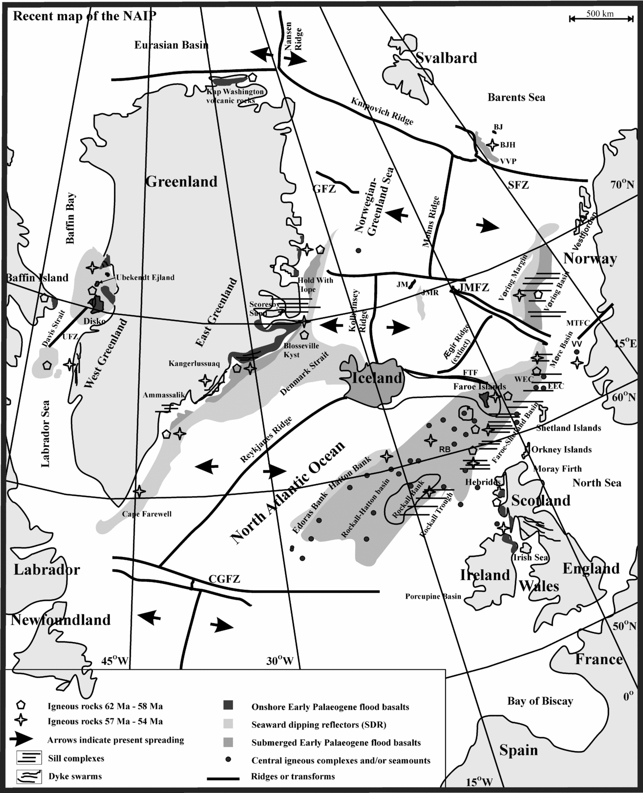
The North Atlantic Igneous Province (NAIP) is a classic Large Igneous Province associated with a volcanic rifted margin. It has traditionally been considered to comprise the voluminous Palaeogene igneous rocks occurring at the conjugate E Greenland–NW European margins and in the W Greenland–Baffin Bay area (Upton, Reference Upton, Morton and Parson1988; Saunders et al. Reference Saunders, Fitton, Kerr, Norry and Kent1997; Meyer, Van Wijk & Gernigon, Reference Meyer, Van Wijk and Gernigon2007 and references therein). Other contemporaneous magmatism occurred in the northernmost parts of Greenland (Kap Washington Group at c. 64±3 Ma, (Estrada, Höhndorf & Henjes-Kunst, Reference Estrada, Höhndorf and Henjes-Kunst2001) and in the W Barents Sea (Vestbakken Volcanic Province, c. 54 Ma, (Tsikalas, Eldholm & Faleide, Reference Tsikalas, Eldholm and Faleide2002) (Fig. 1).
Simplified geological map of the North Atlantic Igneous Province and surrounding areas modified from Saunders et al. (Reference Saunders, Fitton, Kerr, Norry and Kent1997); Nielsen, Larsen & Hopper (Reference Nielsen, Larsen and Hopper2002) and Nielsen, Stephenson & Thomson (Reference Nielsen, Stephenson and Thomsen2007). The ages are from the references in Table 1. The Early Palaeogene transient regional uplifts are from references in Table 2. The central igneous complexes and/or seamounts are modified from Bull & Masson (Reference Bull and Masson1996); Ritchie, Hitchen & Edwards (Reference Ritchie, Hitchen and Edwards1997); Naylor et al. (Reference Naylor, Bell, Jolley, Durnall and Fredsted1999); Edwards (Reference Edwards2002); Hitchen (Reference Hitchen2004); Archer et al. (Reference Archer, Bergman, Iliffe, Murphy and Thornton2005). Abbreviations: BJ – Bjørnøya; BJH – Bjørnøya High; CGFZ – Charlie Gibbs Fracture Zone; EEC – East Erlend Complex; FTF – Faroe Transform Fault; GFZ – Greenland Fracture Zone; JM – Jan Mayen; JMFZ – Jan Mayen Fracture Zone; JMR – Jan Mayen Ridge; MTFC – Møre–Trøndelag Fault Complex; RB – Rosemary Bank; SFZ – Senja Fracture Zone; UFZ – Ungava Fracture Zone; VV – Vestbrona Volcanic rocks; VVP – Vestbakken Volcanic Province; WEC – West Erlend Complex.

The major Early Palaeogene NAIP rocks can be regionally divided into: W Greenland–Baffin Island, SE Greenland, (central–east) CE Greenland, NE Greenland, Vøring margin, Møre margin, Faroe Islands, Rockall–Hatton area, Faroe–Shetland Basin, Rockall Trough and the NW British Isles (Saunders et al. Reference Saunders, Fitton, Kerr, Norry and Kent1997) (Fig. 1). Other contemporaneous, smaller and more isolated parts of the NAIP are also shown in Figure 1. The CE Greenland–Faroe Islands Ridge and Iceland formed subsequent to the onset of sea-floor spreading in the area (Meyer, Van Wijk & Gernigon, Reference Meyer, Van Wijk and Gernigon2007). Exposed and submerged basaltic rocks of the NAIP extend roughly NE–SW for more than 2000 km along the conjugate East Greenland–NW European margins (Saunders et al. Reference Saunders, Fitton, Kerr, Norry and Kent1997) (Fig. 1). The extrusive rocks of the province cover a surface area of at least ~1.3 × 10⁶ km2, while the extrusive and intrusive rocks of the NAIP are together estimated to comprise a volume of ~6.6 × 10⁶ km3 (Eldholm & Grue, Reference Eldholm and Grue1994). The majority of the extrusive rocks at the conjugate E Greenland–NW European margins (the Faroe Islands; Rockall–Hatton and Vøring–Møre) were extruded in subaerial or shallow-marine environments onto continental crust (e.g. Natland & Winterer, Reference Natland and Winterer2005). Similarly, the vast majority of the Early Palaeogene W Greenland igneous products were emplaced in continental crust (e.g. Larsen et al. Reference Larsen, Rex, Watt and Guise1999a) in a subaerial and/or in a shallow marine environment (Storey et al. Reference Storey, Duncan, Pedersen, Larsen and Larsen1998).
Here we use published studies to show that the formation of the NAIP could have been aided by the combined actions of a number of magmatic centres, whose initial actions in part were governed by regional and/or provincial plate tectonic reorganizations.
2. Geological setting prior to and during magmatism
In the context of a large igneous province such as the NAIP, it is pertinent to consider relevant tectonic events prior to the onset of magmatism and to consider possible temporal and spatial links between the igneous products.
2.a. Tectonic settings
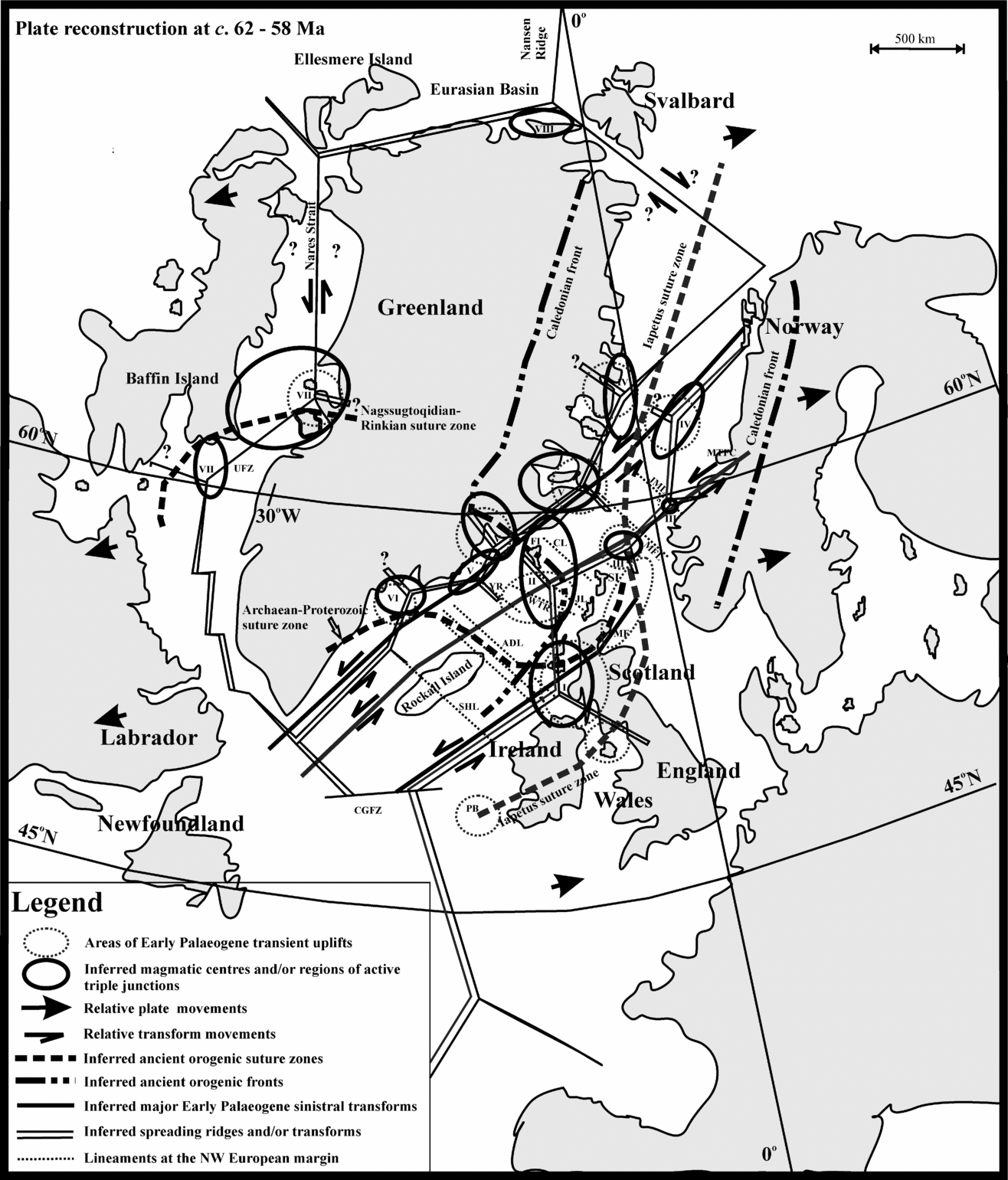
Following the closure of the Iapetus Ocean and the collapse of the Caledonian Orogen in Silurian–Devonian times (Roberts, Reference Roberts2003), the proto-North Atlantic area to the south of the Caledonian front (Figs 2, 3) was underlain by a patchwork of Archaean and Proterozoic terranes (Dickin, Reference Dickin1992).
Simplified map of the NAIP at around 62 to 58 Ma modified from Torsvik et al. (Reference Torsvik, Van Der Voo, Meert, Mosar and Walderhaug2001) and Torsvik, Mosar & Eide (Reference Torsvik, Mosar and Eide2001). The inferred locations of the Caledonian fronts and the Iapetus suture zone are from: Bott (Reference Bott1987); Soper et al. (Reference Soper, Strachan, Holdsworth, Gayer and Greiling1992); Ziegler (Reference Ziegler1992); Masson, Hauser & Jacob (Reference Masson, Hauser and Jacob1999); Skogseid et al. (Reference Skogseid, Planke, Faleide, Pedersen, Eldholm, Neverdal and Nøttvedt2000); Hansen & Brooks (Reference Hansen and Brooks2002); Roberts (Reference Roberts2003); Foulger, Natland & Anderson (Reference Foulger, Natland and Anderson2005a, Reference Foulger, Natland and Andersonb); Cocks (Reference Cocks2005). The inferred Archaean–Proterozoic suture zone in the Rockall–Hatton–NW Britain area is modified from Dickin (Reference Dickin1992). The inferred Nagssuqtocidian–Rinkian suture zone in the Disko region is modified from Krawiec (A. Krawiec, unpub. M.S. thesis, Univ. Texas Austin, 2003) and Connelly et al. (Reference Connelly, Thrane, Krawiec and Garde2006). The three major sinistral transforms are modified from Nielsen, Stephenson & Thomsen (Reference Nielsen, Stephenson and Thomsen2007). Broadly NW-trending lineaments at the NW European margin are modified from Kimbell et al. (Reference Kimbell, Ritchie, Johnson, Gatliff, Doré and Vining2005). General spreading directions are from Harrison et al. (Reference Harrison, Mayr, McNeil, Sweet, McIntyre, Eberle, Harington, Chalmers, Dam and Nøhr-Hansen1999) and Nielsen, Stephenson & Thomsen (Reference Nielsen, Stephenson and Thomsen2007). Abbreviations: ADL – Anton Dohrn Lineament; CGFZ – Charlie Gibbs Fracture Zone; CL – Claire Lineament; JL – Judd Lineament; JML – Jan Mayen Lineament; FI – Faroe Islands; MF – Moray Firth; MFL – Marflo Lineament; MTFC – Møre–Trøndelag Fault Complex; PB – Porcupine Basin; SHL – South Hatton Lineament; SI – Shetland Islands; UFZ – Ungave Fault Zone; WTR – Wyville-Thomson Ridge; YR – Ymir Ridge. See text for further explanation.

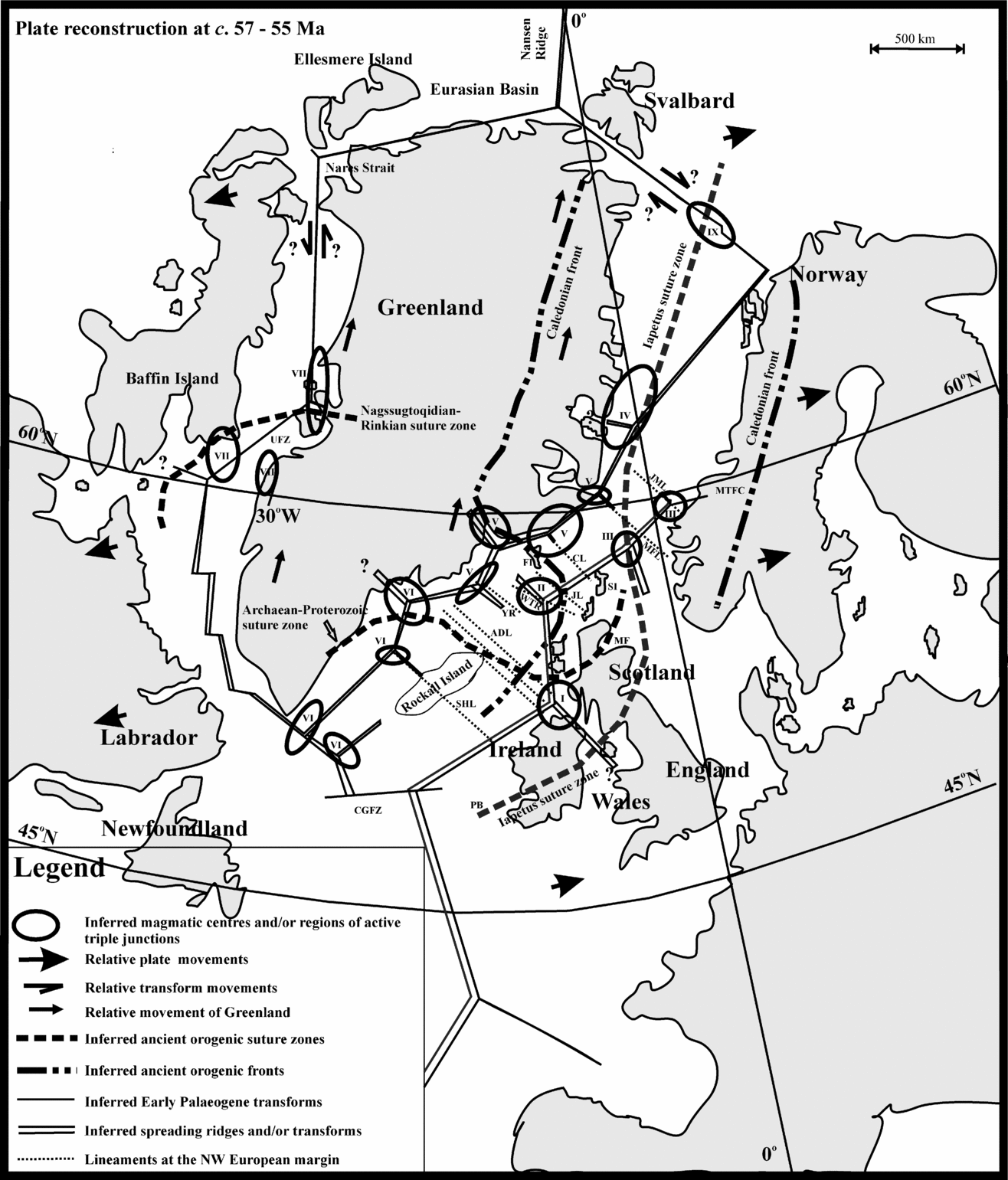
Simplified map of the NAIP at around 57 to 55 Ma modified from Torsvik et al. (Reference Torsvik, Van Der Voo, Meert, Mosar and Walderhaug2001) and Torsvik, Mosar & Eide (Reference Torsvik, Van Der Voo, Meert, Mosar and Walderhaug2001). Explanation and abbreviations as in Figure 2. See text for further explanation.

Permian and Triassic broadly E–W-directed extension between Eurasia and Greenland resulted in the formation of numerous large half-graben basins widely distributed at the margins (Ziegler, Reference Ziegler1989; Brekke et al. Reference Brekke, Dahlgren, Nyland and Magnus1999; Doré et al. Reference Doré, Lundin, Jensen, Birkeland, Eliassen, Fichler, Fleet and Boldy1999; Surlyk, Reference Surlyk, Hardman and Brooks1990). Jurassic E–W extension between Eurasia and North America–Greenland gave way to a dominantly NW–SE-directed extension in Early to Middle Cretaceous times (Doré et al. Reference Doré, Lundin, Jensen, Birkeland, Eliassen, Fichler, Fleet and Boldy1999). The Middle Cretaceous extension resulted in northwards-narrowing sea-floor spreading from the Rockall Trough to the Vøring Basin off W Norway (Price & Rattey, Reference Price and Rattey1984). Renewed NW–SE-directed extension occurred in the proto-NAIP area from the Late Cretaceous to the Early Palaeogene (Doré et al. Reference Doré, Lundin, Jensen, Birkeland, Eliassen, Fichler, Fleet and Boldy1999). This event led to the initiation of sea-floor spreading in the Labrador Sea in the Early Paleocene (Chalmers & Laursen, Reference Chalmers and Laursen1995) and the initiation and northwards propagation of sea-floor spreading at the conjugate NW European–E Greenland margins in Early Eocene times (Ziegler, Reference Ziegler1989, Reference Ziegler1992; Doré et al. Reference Doré, Lundin, Jensen, Birkeland, Eliassen, Fichler, Fleet and Boldy1999). At around the same time, the Eurasian Basin began to open (Ziegler, Reference Ziegler1989). Early Palaeogene exploitation/reactivation of Precambrian and Caledonian fault zones are inferred for the early phases of continental rifting and NAIP formation (Doré et al. Reference Doré, Lundin, Fichler and Olesen1997, Reference Doré, Lundin, Jensen, Birkeland, Eliassen, Fichler, Fleet and Boldy1999).
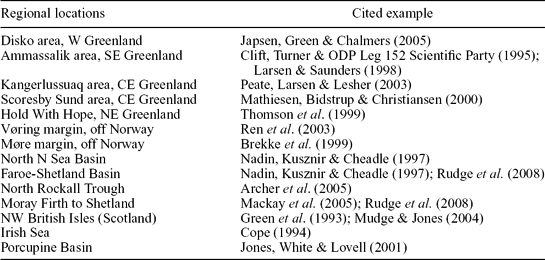
Regional vertical movements and the formation of transient domal uplifts preceded the main phases of Early Palaeogene igneous activities in many parts of the NAIP (e.g. Maclennan & Jones, Reference Maclennan and Jones2006; Meyer, Van Wijk & Gernigon, Reference Meyer, Van Wijk and Gernigon2007; Saunders et al. Reference Saunders, Jones, Morgan, Pierce, Widdowson and Xu2007). Published examples of some regional domal uplifts are listed in Table 2 (Fig. 2). Without constraining the depth of origin, Saunders et al. (Reference Saunders, Jones, Morgan, Pierce, Widdowson and Xu2007) suggested that the ascent of narrow hot mantle jets and broadly contemporaneous rifting in areas of uplifts generated doming.
2.b. Igneous settings
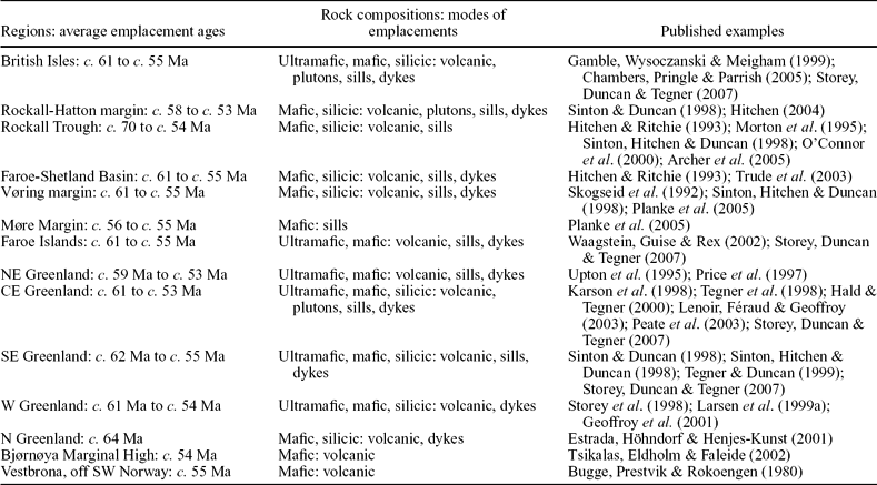
While the igneous rocks of the NAIP cover a compositional spectrum from picrites to silicic rocks (Table 1), most of the rocks encountered in the province today are of basaltic composition (e.g. Saunders et al. Reference Saunders, Fitton, Kerr, Norry and Kent1997). Crustally contaminated rocks occur at or close to the base of volcanic successions in many parts of the basaltic sequences of the province (Gibson, Reference Gibson2002). The igneous products include both fissure or pointsource fed lava-flows (Peate, Larsen & Lesher, Reference Peate, Baker, Blichert-Toft, Hilton, Storey, Kent, Brooks, Hansen, Pedersen and Duncan2003; Single & Jerram, Reference Single and Jerram2004; Passey & Bell, Reference Passey and Bell2007), water-influenced and water-lain volcanic successions (e.g. Peate, Larsen & Lesher, Reference Peate, Larsen and Lesher2003; Jerram et al. Reference Jerram, Single, Hobbs and Nelson2009, this issue) and ignimbrites as well as plutonic or sheet intrusions (sills and/or dykes) (Table 1; Fig. 1), each reflecting the processes and crustal environment that prevailed in that particular area during melt emplacement. Most of the igneous activity of the NAIP occurred in the time span from c. 62 to c. 53 Ma. Two main periods of melt emplacement have been inferred for the NAIP, with ages of c. 62 to 58 Ma and c. 57 to 53 Ma, and detectable peaks at c. 60 Ma and at c. 55 Ma, respectively (Saunders et al. Reference Saunders, Fitton, Kerr, Norry and Kent1997; Torsvik, Mosar & Eide, Reference Torsvik, Mosar and Eide2001; Jerram & Widdowson, Reference Jerram and Widdowson2005; Meyer, Van Wijk & Gernigon, Reference Meyer, Van Wijk and Gernigon2007) (Table 1; Fig. 1). Smaller-scale igneous activity preceded these main periods in, for example, the N Rockall Trough (Morton et al. Reference Morton, Hitchen, Ritchie, Hine, Whitehouse and Carter1995; O'Connor et al. Reference O'Connor, Stoffers, Wijbrans, Shannon and Morrissey2000), continued subsequently in parts of the NAIP area for tens of millions of years (e.g. Tegner & Duncan, Reference Tegner and Duncan1999; O'Connor et al. Reference O'Connor, Stoffers, Wijbrans, Shannon and Morrissey2000; Tegner et al. Reference Tegner, Brooks, Duncan, Heister and Bernstein2008), and is continuing on Iceland and on the island of Jan Mayen (e.g. Trønnes et al. Reference Trønnes, Planke, Sundvoll and Imsland1999) (Table 1; Fig. 1).
Summary of Early Palaeogene ages for the key regions of the North Atlantic Igneous Province (most studies are overlapping and fall within the time frames from c. 62 Ma to c. 53 Ma)

The ages presented in this table reflect only the initial main phases of NAIP magmatism. Subsequent magmatism occurred in many of the same regions as those presented in this table. For further information see e.g. Tegner et al. (Reference Tegner, Brooks, Duncan, Heister and Bernstein2008), Morton et al. Reference Morton, Hitchen, Ritchie, Hine, Whitehouse and Carter1995 and O'Connor et al. (Reference O'Connor, Stoffers, Wijbrans, Shannon and Morrissey2000) and references in these papers.
3. The spatial distribution of known and inferred magmatic centres of the NAIP
It is noticeable that many of the inferred earliest igneous activities in the NAIP coincide well with some of the transient uplifts recorded for this period (Figs 1, 2; Tables 1, 2). Furthermore, it appears that a number of the uplifted regions and the parts of the NAIP with the most voluminous igneous production for this period, namely in the NW British Isles, the Faroe Islands, (central-east) CE Greenland and the Disko region in W Greenland (Upton, Reference Upton, Morton and Parson1988; Saunders et al. Reference Saunders, Fitton, Kerr, Norry and Kent1997; Meyer, Van Wijk & Gernigon, Reference Meyer, Van Wijk and Gernigon2007), were emplaced in the vicinity of old orogenic sutures and/or fronts from the Palaeozoic Caledonian Orogen, at suture zones between Archaean–Proterozoic terranes at the conjugate East Greenland–NW European margins and at the suture zone between the Archaean Nagssugtoqidian–Rinkian Orogen in the Disko–Baffin Island area (Figs 1, 2, 3).
Early Palaeogene transient uplifts reported for regions within the North Atlantic Igneous Province

In a reconstructed map of the NAIP region intended to show the spatial distribution of the igneous activities for the Middle Paleocene (Fig. 2; Table 1), the magmatic regions and/or centres at the conjugate E Greenland–NW European margins seem to form conspicuous double zigzag and roughly NNE–SSW-directed trends, from just to the north of Hold With Hope and southwards to the Ammassalik area along the E Greenland margin and from the Vøring area and southwards to the NW British Isles area at the NW European margin, converging at the CE Greenland–Faroe Islands area. According to current published data the igneous activities in N and W Greenland were spatially isolated from these events.
The suggested trends of igneous activities at the conjugate E Greenland–NW European margin from the Middle Paleocene seem to be more or less repeated in the Early Eocene (Fig. 3; Table 1), apart from the westward relocation of magmatism at the Vøring margin, the eastward relocation of magmatism at the Blosseville Kyst and the establishment of volcanism in the W Barents Sea. Final sea-floor spreading at the Blosseville Kyst latitude occurred further to the east at c. 54 Ma (Bott, Reference Bott1985).
Each part of the double zigzag geometry for the inferred Early Palaeogene magmatic trends of the NAIP in the NE Atlantic area (Figs 2, 3) seems to resemble the classic rifting trends associated with the embryonic stages of continental rifting where the surface expression of the rift processes appears as interconnected triple junctions at various stages of development (Burke & Dewey, Reference Burke and Dewey1973; Ziegler, Reference Ziegler1989; Park, Reference Park1995; Sears, George & Winne, Reference Sears, George and Winne2005).
3.a. The NW British Isles(Fig. 1; ‘I’ in Figs 2, 3)
A magmatic centre at an Early Palaeogene triple junction in the Hebrides–Ireland area has been inferred to have caused the contemporaneous magmatism in the NW British Isles (Burke & Dewey, Reference Burke and Dewey1973; Geoffroy, Bergerat & Angelier, Reference Geoffroy, Bergerat and Angelier1996). In accepting the presence of a junction in this region, a broadly SE-trending failed rift arm or leaky transform with NE–SW to ENE–WSW-directed extension fits roughly with the observed orientation of dykes (NW–SE to NNW–SSE-directed) emplaced in NW Britain during this period (Speight et al. Reference Speight, Skelhorn, Sloan, Knaap and Sutherland1982; England, Reference England, Morton and Parson1988; Geoffroy, Bergerat & Angelier, Reference Geoffroy, Bergerat and Angelier1996). The later Eocene extension in NW Britain has been interpreted to result from broadly NW–SE-directed crustal extension associated with the opening of the North Atlantic (Geoffroy, Bergerat & Angelier, Reference Geoffroy, Bergerat and Angelier1996). The Early Palaeogene magmatism in NW Britain has been associated with melting of the ‘Iceland Plume’ (Kent & Fitton, Reference Kent and Fitton2000; Upton et al. Reference Upton, Skovgaard, McClurg, Kirstein, Cheadles, Emeleus, Wadsworth and Fallick2002), although Nadin, Kusznir & Cheadle (Reference Nadin, Kusznir and Cheadle1997) tentatively suggested that a separate distinct mantle plume may have been active in the NW Britain area during this period. Tectonic activity has also been invoked by some authors to have facilitated melt generation in the area (Upton et al. Reference Upton, Skovgaard, McClurg, Kirstein, Cheadles, Emeleus, Wadsworth and Fallick2002; Chambers, Pringle & Parrish, Reference Chambers, Pringle and Parrish2005).
3.b. The Faroe Islands–N Rockall Trough (Fig. 1; ‘II’ in Figs 2, 3)
Geoffroy, Bergerat & Angelier (Reference Geoffroy, Bergerat and Angelier1994) suggested that an Early Palaeogene triple junction was more or less centred on the Faroe Islands, while Burke & Dewey (Reference Burke and Dewey1973) proposed a contemporaneous triple junction in the Faroes–N Rockall Trough area with magmatic centres in the N Rockall Trough and to the SSW and/or SW off the Faroe Islands. This accords with the inferences by Waagstein (Reference Waagstein, Morton and Parson1988) regarding the depocentre of the Faroe Islands Beinisvørð Formation (formerly lower basalt series: e.g. Passey & Bell, Reference Passey and Bell2007) being located in the southern or central part of the Faroe Islands area. A NW-trending failed rift arm or leaky transform from this inferred junction(s) or from a junction that migrated within this region during Paleocene and Eocene times with relative extension directed towards the NE–SW and another rift arm or leaky transform with extension towards the NNW–SSE may explain the NW–SE and ENE–WSW sub-parallel igneous emplacement trends of contemporaneous central igneous complexes in the SW parts of the area (e.g. Archer et al. Reference Archer, Bergman, Iliffe, Murphy and Thornton2005), as well as NW-trending lineaments reported for this region (e.g. Johnson et al. Reference Johnson, Ritchie, McInroy and Kimbell2005; Kimbell et al. Reference Kimbell, Ritchie, Johnson, Gatliff, Doré and Vining2005). A hypothetical connection between a Faroese and a NW British triple junction (Figs 2, 3) would presumably have been sub-parallel to the N–S-trending contemporaneous dykes in mainland Scotland to the E and S of Skye (e.g. Speight et al. Reference Speight, Skelhorn, Sloan, Knaap and Sutherland1982). Morton et al. (Reference Morton, Hitchen, Ritchie, Hine, Whitehouse and Carter1995) tentatively suggested that volcanism at the Rosemary Bank (Fig. 1) in the N Rockall Trough was due to a separate underlying source, and Hitchen et al. (Reference Hitchen, Morton, Mearns, Whitehouse and Stoker1997) likewise suggested a local source for the Early Palaeogene rocks in the area. Other authors have associated the Early Palaeogene magmatism in this area with the ‘Iceland plume’ (Holm, Hald & Waagstein, Reference Holm, Hald and Waagstein2001; Archer et al. Reference Archer, Bergman, Iliffe, Murphy and Thornton2005).
3.c. The NE Faroe–Shetland Basin; N North Sea; offshore W Norway (Fig. 1; ‘III’ in Figs 2, 3)
An Early Palaeogene triple junction to the NNE off Shetland has been suggested by Burke & Dewey (Reference Burke and Dewey1973), and an additional contemporaneous magmatic centre was active further to the NNE off the SW Norwegian coast. Based on reported Early Palaeogene uplifts and igneous activity in the area, Mudge & Jones (Reference Mudge and Jones2004) and Rudge et al. (Reference Rudge, Champion, White, McKenzie and Lovell2008) suggested that the ‘Iceland Plume’ could be responsible for contemporaneous uplifts recorded in the northern North Sea and the NE Faroe–Shetland Basin area. Kanaris-Sotiriou, Morton & Taylor (Reference Kanaris-Sotiriou, Morton and Taylor1993) interpreted the Early Palaeogene basaltic and associated intermediate volcanic rocks of the Erlend Complex in the northern North Sea to be a result of extensional volcanism in the area. The Møre–Trøndelag Fault Complex, which extends offshore from the SW Norwegian coast, trends towards the area of this inferred junction and is thought to have been active in Early Palaeogene times (Doré et al. Reference Doré, Lundin, Fichler and Olesen1997; Redfield et al. Reference Redfield, Torsvik, Andriessen and Gabrielsen2004) and could have been linked to the contemporaneous igneous activity in the area. Torske & Prestvik (Reference Torske and Prestvik1991) tentatively suggested that the igneous products recorded off W Norway were related to an Early Palaeogene precursor to the subsequent Jan Mayen Fracture Zone (Fig. 1).
3.d. The Vøring margin; NE Greenland (Fig. 1; ‘IV‘ in Figs 2, Reference Barrat, Fourcade, Jahn, Cheminée and Capdevila3)
The inferred magmatic activity at the Vøring margin in Early Palaeogene times occurred at some distance from the future break-up zone in the region, but moved westwards with time (Eldholm, Thiede & Taylor, Reference Eldholm, Thiede and Taylor1989). Early Eocene magmatism in NE Greenland and at the Vøring margin had a close spatial relationship (Viereck et al. Reference Viereck, Taylor, Parson, Hertogen, Gibson, Morton and Parson1988; Upton et al. Reference Upton, Emeleus, Rex and Thirlwall1995) and recent studies reveal a continuous Early Eocene igneous complex that directly linked these two regions together in the early stages of sea-floor spreading (Olesen et al. Reference Olesen, Ebbing, Lundin, Mauring, Skilbrei, Torsvik, Hansen, Henningsen, Midbøe and Sand2007). The igneous activities (volume and rock types) associated with these centres resemble those found in some places in the Rockall Trough (Upton, Reference Upton, Morton and Parson1988) and on the NW British Isles (Viereck et al. Reference Viereck, Taylor, Parson, Hertogen, Gibson, Morton and Parson1988 and references therein). Volumes of the Paleocene to Early Eocene volcanism decreased from the central Vøring margin towards the south and north, respectively (Berndt et al. Reference Berndt, Planke, Alvestad, Tsikalas and Rasmussen2001), indicating melt supplies from a relatively confined magmatic source. An ‘Iceland Plume’ origin has been inferred for the NE Greenland magmatism (e.g. Upton et al. Reference Upton, Emeleus, Rex and Thirlwall1995) and for the igneous products at the Vøring margin by some authors (Skogseid et al. Reference Skogseid, Pedersen, Eldholm, Larsen, Storey, Alabaster and Pankhurst1992). Conversely, Eldholm, Thiede & Taylor (Reference Eldholm, Thiede and Taylor1989) and Van Wijk et al. (Reference Van Wijk, Huismans, Ter Voorde and Cloetingh2001) suggested that decompression melting triggered by rifting caused the magma generation at the Vøring margin. Recent re-interpretations of available magnetic, bathymetric, gravity and seismic data from the Vøring margin strongly suggest local Eocene magmatism related to an Azores-type triple junction linked to the embryonic stages of sea-floor spreading in the Norwegian–Greenland Sea (Gernigon et al. Reference Gernigon, Olesen, Ebbing, Wienecke, Gaina, Mogaard, Sand and Myklebust2008).
3.e. The (central-east) CE Greenland (Fig. 1; ‘V’ in Figs 2, 3)
The voluminous and widespread igneous products in this region were probably the result of several contemporaneous magmatic centres (e.g. Callot, Geoffroy & Brun, Reference Callot, Geoffroy and Brun2002). The locations of hypothetical triple junctions at the CE Greenland margin have been estimated from Early Palaeogene magmatism and uplifts in the area (Larsen & Watt, Reference Larsen and Watt1985; Nielsen, Reference Nielsen, Fitton and Upton1987; Mathiesen, Bidstrup & Christiansen, Reference Mathiesen, Bidstrup and Christiansen2000; Callot, Geoffroy & Brun, Reference Callot, Geoffroy and Brun2002; Peate, Larsen & Lesher, Reference Peate, Baker, Blichert-Toft, Hilton, Storey, Kent, Brooks, Hansen, Pedersen and Duncan2003) and from triple junction localities as suggested by Burke & Dewey (Reference Burke and Dewey1973); Karson & Brooks (Reference Karson, Brooks, Niocaill and Ryan1999) and Tegner et al. (Reference Tegner, Brooks, Duncan, Heister and Bernstein2008). This vast area was characterized by Early Palaeogene episodic igneous activity and frequent migration of magmatic centres (Larsen & Watt, Reference Larsen and Watt1985; Peate, Larsen & Lesher, Reference Peate, Larsen and Lesher2003), and at least three separate rifting events have been recorded for this region, some of which occurred far inland (Nielsen, Reference Nielsen, Fitton and Upton1987; Olesen et al. Reference Olesen, Ebbing, Lundin, Mauring, Skilbrei, Torsvik, Hansen, Henningsen, Midbøe and Sand2007). The rifting associated with the bulk of the magmatism in CE Greenland and the Faroe Islands approximately at anomaly 24 (c. 55 Ma) occurred close to the Blosseville Kyst (Larsen & Watt, Reference Larsen and Watt1985; Nielsen, Reference Nielsen, Fitton and Upton1987; Larsen et al. Reference Larsen, Waagstein, Pedersen and Storey1999b). This is in accordance with inferences that the magmas of the younger basalt formations of the then neighbouring Faroe Islands were supplied from the north during this period (Waagstein, Reference Waagstein, Morton and Parson1988; Larsen et al. Reference Larsen, Waagstein, Pedersen and Storey1999b). The onset of final sea-floor spreading at the Blosseville Kyst latitude occurred further to the east along the now extinct Ægir Ridge at c. 54 Ma (Bott, Reference Bott1985). On the one hand, Larsen & Marcussen (Reference Larsen, Marcussen, Storey, Alabaster and Pankhurst1992) and Hanghøj, Storey & Stecher (Reference Hanghøj, Storey and Stecher2003) considered the magmatism in CE Greenland to be related to extension in the area; on the other hand, authors such as Tegner et al. (Reference Tegner, Brooks, Duncan, Heister and Bernstein2008 and references therein) suggested that the CE Greenland igneous products resulted from actions of the ‘Iceland Plume’.
3.f. The Hatton–Edoras margin; SE Greenland (Fig. 1; ‘VI’ in Figs 2, 3)
Only parts of this extensive area have been investigated in detail, but the close proximity in the Early Palaeogene suggest that these two margins perhaps shared some magmatic centres prior to the sea-floor spreading in the region (Figs 2, 3). Locations for some possible triple junctions in this region in Early Palaeogene times have been implied previously by Burke & Dewey (Reference Burke and Dewey1973), Bull & Masson (Reference Bull and Masson1996), Karson & Brooks (Reference Karson, Brooks, Niocaill and Ryan1999), Nielsen, Larsen & Hopper (Reference Nielsen, Larsen and Hopper2002) and Nielsen, Stephenson & Thomsen (Reference Nielsen, Stephenson and Thomsen2007), and locations of some separate large magmatic centres and domal uplifts have been recorded by Morgan & Barton (Reference Morgan and Barton1990), Barton & White (Reference Barton and White1997), Larsen & Saunders (Reference Larsen and Saunders1998) and Elliot & Parson (Reference Elliot and Parson2008). A hypothetical SE-trending failed rift arm or transform from a triple junction in the southern parts of the Hatton Bank (Figs 2, 3) would be sub-parallel to the South Hatton Lineament (Johnson et al. Reference Johnson, Ritchie, McInroy and Kimbell2005; Kimbell et al. Reference Kimbell, Ritchie, Johnson, Gatliff, Doré and Vining2005). Another major lineament intersecting the Hatton margin is the Anton Dohrn Lineament, which in part has been interpreted by Dickin (Reference Dickin1992) to include an ancient orogenic suture zone (Figs 2, 3). Morgan & Barton (Reference Morgan and Barton1990) detected a large separate Early Palaeogene magmatic centre on the NW Hatton Bank, and recent work by Elliot & Parson (Reference Elliot and Parson2008) revealed that the Hatton rifted margin could be divided into three separate segments, each with a distinctive magmatic evolution. They tentatively suggested that the northern parts of the Hatton margin only experienced diffuse spreading in the Early Palaeogene prior to Chron 21 (c. 50 Ma) when regular coherent spreading was established. The phenomenon of diffuse sea-floor spreading has been inferred to reflect low obliquity rifting in a magmatically starved environment (e.g. Corti et al. Reference Corti, Bonini, Innocenti, Manetti and Mulugeta2001). In the southernmost parts of this margin, Elliot & Parson (Reference Elliot and Parson2008) recorded relatively concentrated syn- to post-break-up volcanism. Most authors infer the ‘Iceland Plume’ to be the main source for the magmatism in these two margins (Barton & White, Reference Barton and White1997; Fitton et al. Reference Fitton, Larsen, Saunders, Hardarson and Kempton2000), but Edwards (Reference Edwards2002) considered any ‘Iceland Plume’-dominated processes further eastwards toward the Rockall–Hatton Basin to be problematic, and Barton & White (Reference Barton and White1997) suggested that there was no major long-distance lateral migration of the melts supplying the magmatism at the Edoras Bank.
3.g. The West Greenland–Baffin Island area (Fig. 1; ‘VII’ in Figs 2, 3)
Based on reported locations for large concentrations of Early Palaeogene igneous products (e.g. Chalmers, Larsen & Pedersen, Reference Chalmers, Larsen and Pedersen1995; Skaarup, Jackson & Oakey, Reference Skaarup, Jackson and Oakey2006), large contemporaneous igneous centres (Callot, Geoffroy & Brun, Reference Callot, Geoffroy and Brun2002), doming (Japsen, Green & Chalmers (Reference Japsen, Green and Chalmers2005) and the trends of major faults thought to have been active in the same period (Chalmers, Larsen & Pedersen, Reference Chalmers, Larsen and Pedersen1995; Geoffroy et al. Reference Geoffroy, Callot, Scaillet, Skuce, Gélard, Ravilly, Angelier, Bonin, Cayet, Perrot and Lepvrier2001; Callot, Geoffroy, Brun, Reference Callot, Geoffroy and Brun2002; Skaarup, Jackson & Oakey, Reference Skaarup, Jackson and Oakey2006), the location of a hypothetical triple junction at the southern tip of the Ungava Fault System and another at Ubekendt Ejland around 100 km north of Disko seems to be reasonable. Another triple junction or kink between major faults further to the north between Baffin Island, Ellesmere Island and W Greenland reconstructed back at c. 60 Ma has been interpreted to have been active during the same period (Burke & Dewey, Reference Burke and Dewey1973; Torsvik et al. Reference Torsvik, Van Der Voo, Meert, Mosar and Walderhaug2001; Nielsen, Stephenson & Thomsen, Reference Nielsen, Stephenson and Thomsen2007). Gill, Holm & Nielsen (Reference Gill, Holm and Nielsen1995) associated a presumed high-temperature melting required for the generation of Early Palaeogene picrites in this region with a separate ‘Baffin Bay Plume’ rather than with a distant asymmetrical/irregular ‘Iceland Plume’ as suggested by Chalmers (Reference Chalmers1997) and Storey et al. (Reference Storey, Duncan, Pedersen, Larsen and Larsen1998), among others. The generation of Eocene dykes in SW Greenland and the volcanism along the Ungava Fault System are supposed to have been facilitated by plate reorganizations in the area during that period (Storey et al. Reference Storey, Duncan, Pedersen, Larsen and Larsen1998; Larsen et al. Reference Larsen, Rex, Watt and Guise1999a; Skaarup & Pulvertaft, Reference Skaarup and Pulvertaft2007 and references therein).
3.h. N Greenland (Fig. 1; ‘VIII’ in Fig. 2)
The Early Paleocene Kap Washington Group is thought to have been generated in response to continental rifting related to the break-up of the Laurasian plate (Estrada, Höhndorf & Henjes-Kunst, Reference Estrada, Höhndorf and Henjes-Kunst2001). A contemporaneous triple junction off Kap Washington is in accordance with the study of Torsvik et al. (Reference Torsvik, Van Der Voo, Meert, Mosar and Walderhaug2001); Torsvik, Mosar & Eide (Reference Torsvik, Van Der Voo, Meert, Mosar and Walderhaug2001) and Nielsen, Stephenson & Thomsen (Reference Nielsen, Stephenson and Thomsen2007).
3.i. The W Barents region (Fig. 1; ‘IX’ in Fig. 3)
Volcanic rocks in the W Barents Sea (Vestbakken Volcanic Province) located at the inferred trace of the Caledonian suture zone are interpreted to have formed in response to Early Eocene transtension associated with plate reorganizations in the area (Tsikalas, Eldholm & Faleide, Reference Tsikalas, Eldholm and Faleide2002).
4. Discussion
4.a. Competing theories on the NAIP petrogenesis
A number of theories and geodynamic models (including mantle processes such as delamination, orogenic collapse, small-scale edge-driven convection, melting of fertile mantle, and melting of an individual large mantle plume) have previously been proposed to have caused the Early Palaeogene magmatism of the NAIP (e.g. Meyer, Van Wijk & Gernigon, Reference Meyer, Van Wijk and Gernigon2007 and references therein). Other mantle processes sometimes thought to result in voluminous magmatism in general include decompression melting in response to global-scale extension (Ziegler, Reference Ziegler1992), and melting resulting from spontaneous upwellings of near-solidus buoyant mantle material (Raddick, Parmentier & Scheirer, Reference Raddick, Parmentier and Scheirer2002). Other models applied to lithospheric processes, sometimes suggested to have influenced the NAIP genesis, include: (1) the ‘soft-point model’, where the lithosphere is pre-weakened locally by igneous activity and their sources at depth, thereby localizing extensional stresses, which in turn may control the rift propagation and geometry (Corti et al. Reference Corti, Bonini, Innocenti, Manetti and Mulugeta2001; Callot, Geoffroy & Brun, Reference Callot, Geoffroy and Brun2002; Geoffroy, Reference Geoffroy2005); (2) lithospheric extension due to relaxation of intra-plate tensional stress regimes, which in turn generates numerous centres of extension dispersed over plate-wide areas, perhaps ultimately facilitating rifting (Nielsen, Stephenson & Thomsen, Reference Nielsen, Stephenson and Thomsen2007).
4.b. Exploring potential source regions for the NAIP magmas
Key issues for theories regarding the NAIP petrogenesis include the high temperatures necessary to explain the common occurrence of picrites and the nature of source rocks necessary to explain the heterogeneous compositions of many of the encountered basalts (Meyer, Van Wijk & Gernigon, Reference Meyer, Van Wijk and Gernigon2007). Melting of peridotites, contaminated with various amounts of recycled oceanic crustal material, is frequently invoked to explain the geochemical variations in flood basalt provinces (Kogiso, Hirose & Takahashi, Reference Kogiso, Hirose and Takahashi1998; Yaxley, Reference Yaxley2000; Green & Falloon, Reference Green and Falloon2005). However, as subducted oceanic crustal material is thought to reside in the lower mantle (Zhao, Reference Zhao2004), in the middle mantle (Courtillot et al. Reference Courtillot, Davaille, Besse and Stock2003, Zhao, Reference Zhao2004) and in the upper mantle (Green et al. Reference Green, Falloon, Eggins and Yaxley2001; Donnelly et al. Reference Donnelly, Goldstein, Langmuir and Spiegelman2004), geochemical signatures do not necessarily constrain a certain level of the mantle as the source of origin. Picrites have been interpreted to form at ~1440°C and ~2 GPa (Green et al. Reference Green, Falloon, Eggins and Yaxley2001; Green & Falloon, Reference Green and Falloon2005), and mid-ocean ridge basalts (MORB) are thought to form at temperatures above ~1240°C but below ~1400°C and at depths ranging from ~30 km to ~45 km (Hirose & Kawamoto, Reference Hirose and Kawamoto1995; Presnall, Gudfinnsson & Walter, Reference Presnall, Gudfinnsson and Walter2002). Presnall, Gudfinnsson & Walter (Reference Presnall, Gudfinnsson and Walter2002) showed that a temperature increase of only ~20°C was required to increase melt produtivity from 0 to 24% in a homogeneous peridotitic mantle at near-solidus temperatures. The presence of small amounts of recycled oceanic crust and/or water in peridotitic source rocks is inferred to increase the degree of melting at fixed temperatures (Kogiso, Hirose & Takahashi, Reference Kogiso, Hirose and Takahashi1998; Yaxley, Reference Yaxley2000) and to lower the solidus temperature (Hirose & Kawamoto, Reference Hirose and Kawamoto1995; Yaxley, Reference Yaxley2000; Presnall, Gudfinnsson & Walter, Reference Presnall, Gudfinnsson and Walter2002; Green & Falloon, Reference Green and Falloon2005).
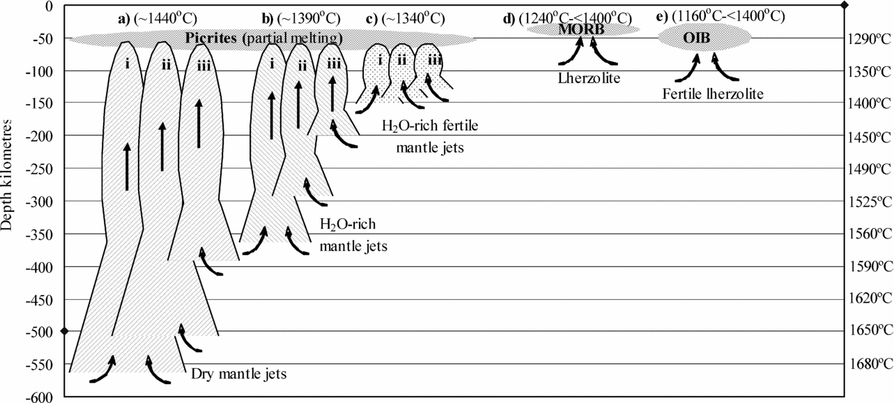
At average geothermal gradients for the upper mantle in an ocean ridge environment (e.g. Blatt & Tracy, Reference Blatt and Tracy1995), adiabatic ascent of uncontaminated potential peridotitic source rocks from depths of >400 km is required in order to produce picrites at ~1440°C and ~2 GPa (Fig. 4a). Substantially shallower depths may be required for picrite genesis from hypothetical assemblages of contaminated and/or hydrated source rocks (Fig. 4b, c). For flood basalts comparable in composition to oceanic island basalts (OIB), melting of enriched/hydrated source rocks would be expected to commence a few tens of kilometres deeper than similar melting of a pure peridotitic counterpart to produce MORB (Yaxley, Reference Yaxley2000) (Fig. 4d, e). In summary, the adiabatic ascent of source material from depths of a few hundred kilometres is probably required in order to provide temperatures realistically needed to produce picrites.
Simplified diagram showing depths versus Mid-Ocean Ridge mantle geotherms (right y axis) from (Blatt & Tracy, Reference Blatt and Tracy1995). (a) Required depths of adiabatic ascent and melting of dry peridotitic source rocks to generate picrites at ~2.0 GPa (around 60 km depth) and at ~1440°C have been calculated/estimated. Adiabatic gradients of (i) 0.60°C km−1 (McKenzie & Bickle, Reference McKenzie and Bickle1988), (ii) 0.54°C km−1 (McKenzie, Jackson & Priestley, Reference McKenzie, Jackson and Priestley2005) and (iii) 0.42°C km−1 (Ichiki et al. Reference Ichiki, Baba, Obayashi and Utada2006) have been applied in the calculations/estimations. In assuming lowering of solidus temperatures of ~50°C for source material containing H2O (Green & Falloon, Reference Green and Falloon2005) and a further decrease of solidus of ~50°C for fertile source material (Yaxley, Reference Yaxley2000) calculations/estimations are carried out for (b) wet and (c) wet + fertile source rocks. However, the scenarios in (b) and (c) may produce normal basalts unless melting starts at deeper levels (e.g. Yaxley, Reference Yaxley2000). (d) MORB generation from partial melting at ~30 to ~45 km depth. (e) Increased melting column for the generation of OIB (oceanic island basalts). See text for further explanation.

4.c. The NAIP in the context of rift geometry and triple junctions
The geometry of the NAIP (Figs 2, 3) and the longevity of the igneous activity, together with the involvement of the Rockall–Faroe Islands microcontinent (Roberts & Searle, Reference Roberts and Searle1979; Edwards, Reference Edwards2002) and the Jan Mayen microcontinent (Kodaira et al. Reference Kodaira, Mjelde, Gunnarson, Shiobara and Shimamura1998; Mjelde et al. Reference Mjelde, Breivik, Raum, Mittelstaedt, Ito and Faleide2008) in the rift processes, suggest a complex and discontinuous break-up history. A comparable complex rifting evolution has been reported for the Afar Volcanic Province with migrating triple junctions and magmatism (Tesfaye, Harding & Kusky, Reference Tesfaye, Harding and Kusky2003; Wolfenden et al. Reference Wolfenden, Ebinger, Yirgu, Deino and Ayalew2004) and where microcontinents (Danakil and Aisha) were involved in the rifting/igneous processes and commonly defined their own secondary triple junctions and associated magmatism (Garfunkel & Beyth, Reference Garfunkel, Beyth, Yirgu, Ebinger and Maguire2006). Individual large mantle plumes have commonly been linked to magmatism, rifting and triple junction formation in flood basalt provinces like the Afar Volcanic Province (Garfunkel & Beyth, Reference Garfunkel, Beyth, Yirgu, Ebinger and Maguire2006) and the NAIP (Section 3), but other authors have argued that the East African rift system in general developed in response to global plate reorganizations (e.g. Wolfenden et al. Reference Wolfenden, Ebinger, Yirgu, Deino and Ayalew2004). The common occurrence of dissimilar geochemical and isotopic signatures in rift-related basalts, within confined areas from, for example, the East African rift system (Barrat et al. Reference Barrat, Fourcade, Jahn, Cheminée and Capdevila1998; Orihashi, Al-Jailani & Nagao, Reference Orihashi, Al-Jailani and Nagao1998; Rogers et al. Reference Rogers, Macdonald, Fitton, George, Smith and Barreiro2000; George & Rogers, Reference George and Rogers2002; Keranen & Klemperer, Reference Keranen and Klemperer2008), from Iceland (Kitagawa et al. Reference Kitagawa, Kobayashi, Makishima and Nakamura2008) and from the Azores (Beier et al. Reference Beier, Haase, Abouchami, Krienitz and Hauff2008), suggests melting from distinct mantle reservoirs.
The association between enhanced magmatism and rift geometry, that is, triple junctions (Sears, George & Winne, Reference Sears, George and Winne2005) or kinks in rifting trends (Abdel-Rahman & Nassar, Reference Abdel-Rahman and Nassar2004; Wolfenden et al. Reference Wolfenden, Ebinger, Yirgu, Deino and Ayalew2004), is well known. In this context the evolution of the proto-Iceland region may be of relevance for the Early Palaeogene NAIP magmatism, as the great increase in the volume of magma production in that area in Middle Palaeogene times (Foulger & Anderson, Reference Foulger and Anderson2005) coincided with the establishment of the ridge–ridge–transform triple junction (Reykjanes ridge–Kolbeinsey ridge–Faroe transform fault) recorded by Bott (Reference Bott1985).
4.d. NAIP in the context of plate tectonic processes in adjacent areas
In the context of Early Palaeogene global plate-tectonic processes, it is noteworthy that the relative convergence and associated compression of Africa and Iberia with respect to W Europe came to a standstill from the earliest Paleocene to the Early Eocene (Rosenbaum, Lister & Duboz, Reference Rosenbaum, Lister and Duboz2002), that is, in the same time interval as the occurrence of the majority of Early Palaeogene NAIP magmatism and the initiation of the continental break-up of the proto-North Atlantic area (Table 1; Figs 1, 2, 3). The causal mechanism for this standstill of relative plate convergence has been tentatively interpreted to result from a contemporaneous continental collision in the Alps between the African and European plates at around 65 Ma (Jolivet & Faccenna, Reference Jolivet and Faccenna2000; Rosenbaum, Lister & Duboz, Reference Rosenbaum, Lister and Duboz2002). A recent complementary tectonic model inferred to have terminated compression and perhaps facilitated extension in the NW Atlantic area in the Early Palaeogene involves major left-lateral displacements between Greenland and Europe and within the NW parts of Europe (Fig. 2) that ultimately resulted in narrowing (contraction) and retreat of the European plate relative to the African plate (Nielsen, Stephenson & Thomsen, Reference Nielsen, Stephenson and Thomsen2007).
In a rifting perspective, Lundin & Doré (Reference Lundin, Doré, Doré and Vining2005) argued that the Early Palaeogene igneous–tectonic activities in the proto-North Atlantic area that generated the NAIP were merely a result/expression of the final phases of the ongoing break-up of Pangaea, spatially and temporally linking the Early Paleocene central Atlantic rifting (e.g. Ziegler, Reference Ziegler1989, Reference Ziegler1992) in the south with the Early Eocene rifting in the Eurasian Basin to the north (e.g. Srivastava, Reference Srivastava1985; Brown, Parsons & Becker, Reference Brown, Parsons and Becker1987).
4.e. Lithospheric strength
An important issue to be addressed in complex large igneous provinces like the NAIP is: what caused the magmatism to be so widespread until a relatively narrow sea-floor-spreading zone was finally established? Clearly, the strength of certain parts of the lithosphere and its relative capability to resist stretching, rupture and/or intrusion of magmas must have played a major role. Studies on lithospheric strength in a laterally homogeneous undeformed lithosphere have been dealt with in a number of studies (e.g. Kohlstedt, Evans & Mackwell, Reference Kohlstedt, Evans and Mackwell1995; Hirth & Kohlstedt, Reference Hirth and Kohlstedt1996; Kusznir & Park, Reference Kusznir, Park, Coward, Dewey and Hancock2002; Van Wijk & Cloetingh, Reference Van Wijk and Cloetingh2002; Jackson et al. Reference Jackson, McKenzie, Priestley and Emmerson2008). In brief, these authors concluded that increased heat flow and high rates of spreading generally resulted in a net weakening of the lithosphere and conversely, very slow spreading rates and low heat flows could result in a net strengthening. Increased fluid pressure further weakens all affected rock assemblages in the lithosphere (Hirth & Kohlstedt, Reference Hirth and Kohlstedt1996; Jackson et al. Reference Jackson, McKenzie, Priestley and Emmerson2008). Upper mantle heterogeneity and the presence of old shear zones in the lithosphere may play a prominent role in incipient rifting both by enhancing partial melting and by reactivation of old shear zones (Holdsworth, Butler & Roberts, Reference Holdsworth, Butler and Roberts1997; Ryan & Dewey, Reference Ryan and Dewey1997; Kohlstedt, Evans & Mackwell, Reference Kohlstedt, Evans and Mackwell1995).
5. Conclusions and closing remarks
In this contribution we have reviewed some key magmatic centres of the NAIP in a geodynamic framework, focusing on their interrelationships and the tectonic developments during the onset and development of the NAIP. The specific conditions directly prior to the onset of the NAIP and the continued development of the region during the Palaeogene, based on the findings of the present study, are highlighted as follows:
(1) The onset of the rifting and igneous activity of the NAIP area was a temporal and spatial continuation of the rifting in the adjacent central Atlantic Ocean to the south and a precursor for the rifting in the Eurasian Basin to the north. The main igneous and tectonic activities in the NAIP in Early Palaeogene times coincide with contemporaneous changes in the relative motion between the European and African plates, which possibly halted the previous compressional regimes in the NW Atlantic during this time span.
(2) Taken all together, the apparent geometry of the main igneous regions of the NAIP at the conjugate E Greenland–NW European margins in particular shows similarities with trends of the embryonic stages of classic continental rifting regimes consisting of numerous more or less interconnected triple junctions. However, the locations of numerous smaller central igneous complexes and/or seamounts at the NW European margin (Fig. 1) do not seem to fit with such a simple rifting model if they all formed contemporaneously with the larger igneous NAIP regions.
(3) An aiding factor to NAIP rifting could have been Early Palaeogene oblique extension and active sinistral transforms (reactivation?) at the conjugate E Greenland–NW European margins (Nielsen, Stephenson & Thomsen, Reference Nielsen, Stephenson and Thomsen2007) (Fig. 2).
(4) While partial melting in the upper mantle to produce the bulk of the (normal) basaltic rocks of the NAIP is not necessarily dependent on deep mantle convection, some ascent of hot mantle jets seems to be required in order to generate the NAIP picrites (Fig. 4).
(5) Whether global plate reorganizations or a single large mantle plume was the driving force for the NAIP evolution, the close proximity of many parts of the NAIP magmatism and transient uplifts to ancient orogenic sutures and/or fronts (Figs 2, 3) suggests that lithospheric control was an important factor in the embryonic stages of magmatism and rifting.
Acknowledgements
This review was compiled by the first author as part of an ongoing Ph.D. project ‘Sub-seismic geometry and influence of intrusions in igneous-affected basins’, sponsored by Chevron, BP and Geysir through the Faroese Competence Development Fund. A. Saunders and J. Maclennan critically reviewed an earlier version of the manuscript. Two anonymous reviewers are thanked for their comments on the recent version of the paper.