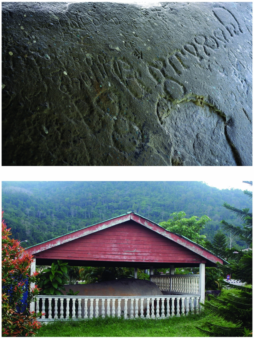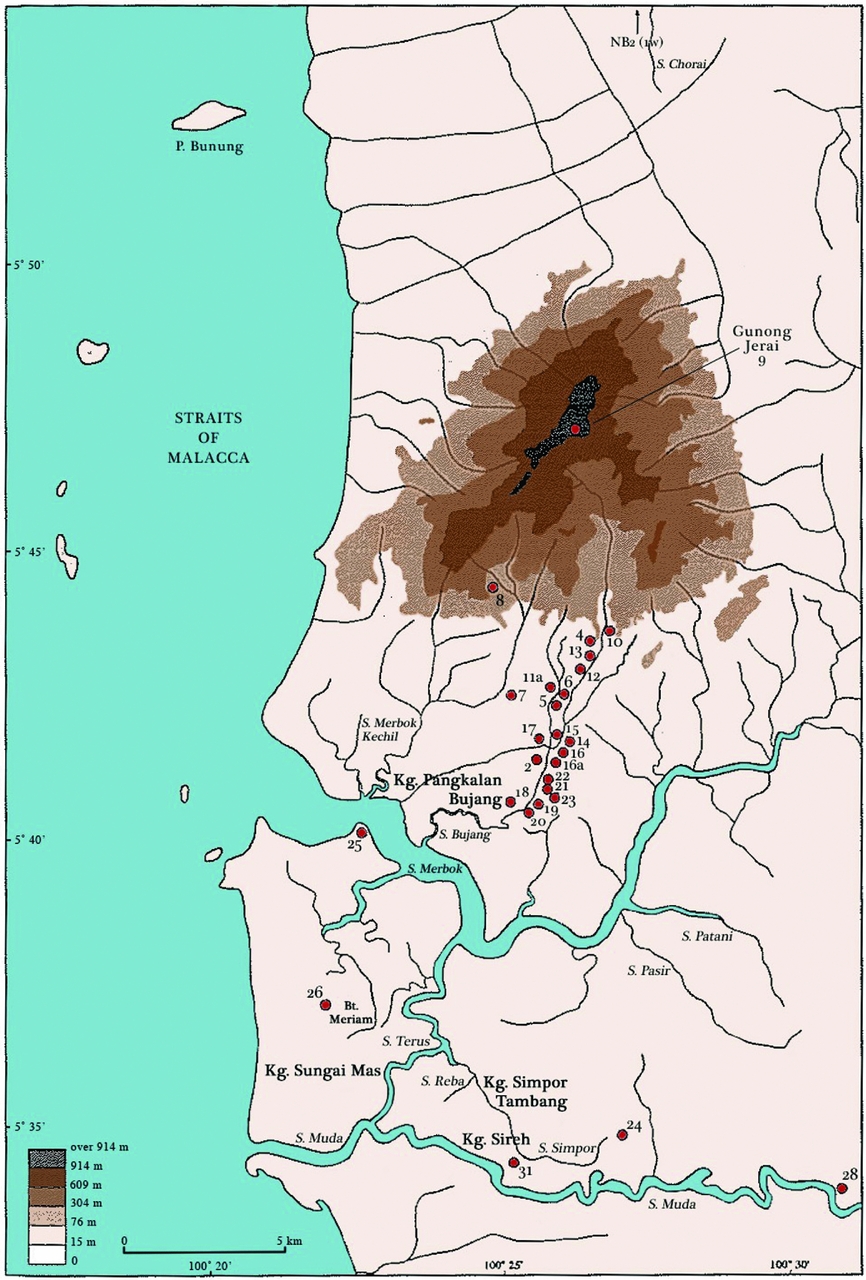


In the early 1830s and 1840s, Colonel James Low, a British colonial officer with the East India Company stationed at Penang, uncovered evidence for an early culture with Indic traits in a river system known as the Bujang Valley.Footnote 1 On the west coast of the Thai-Malay peninsula, the Bujang Valley is today located in the Malaysian state of Kedah (Fig. 1). Among the objects that came to light were a large boulder carved with a variety of Indic scripts and a stele inscription bearing a stupa design and the name of a sea captain Buddhagupta (Fig. 2).Footnote 2 Some fifty years later, F.W. Irby, another colonial resident, discovered the ruins of a temple on the top of nearby Mount Jerai.Footnote 3 This was followed in the 1920s and 1930s by I. H. N. Evans's work in which he compiled an inventory of monuments and artefacts in the area.Footnote 4 However, it wasn't until just before World War II that excavations took place, this time under the direction of H. G. Quaritch Wales and his wife. Their discoveries and subsequent publications led to the first real attempts to explain the origins and extent of this culture and its place within the larger South and Southeast Asian world.Footnote 5
Map of the Thai-Malay Peninsula showing the key sites discussed in this paper.

The Cherok Tokun inscription. Top; detail of the inscription. Bottom; the boulder within the grounds of the Church of St. Anne at Bukit Mertajam. Author's photograph.

At about the same time as James Low was carrying out his explorations from his posting in Penang, plans were afoot in Singapore to establish a museum, the aim of which was to showcase the region's heritage and culture.Footnote 6 To this end, a library was established in 1845 and by 1849 a museum was added. However, it was not until 1874 that a committee was put together to implement the formation of the Raffles Library and Museum. By 1887, the museum had moved from the town hall into its own building and quickly became the major repository in the region for not only historical and archaeological material from the Malay world, but also zoological and ethnographic collections. It was to this museum, therefore, that Quaritch Wales sent the majority of his finds from his Bujang Valley excavations. With the independence of Singapore in 1965, the material stayed within the museum's collection and to this day it remains part of Singapore's national collection.Footnote 7
In the intervening years between Quaritch Wales's excavations and the present day, considerably more research has taken place both within the Bujang Valley region and across Southeast Asia as a whole. For instance, in 2008 the Centre for Global Archaeological Research at the Universiti Sains Malaysia initiated an archaeological research programme in the Bujang Valley led by Professor Mokhtar Saidin. This represents the newest phase of investigations into this complex of sites and it has already produced a number of important discoveries. The focus of its research has been around the area of Sungai Batu, a tributary of the Sungai Merbok. While this area had been noted by scholars in the past, until 2008 no intensive research had been carried out here. As of 2009 – 2010, excavations have unearthed evidence for an iron smelting industry, an ancient brick structure, and another brick structure which appears to be a jetty.Footnote 8 The brick structure (SB1B) is of particular interest, as it appears to be either Buddhist or Hindu. For instance, a Buddhist stone inscription dating to the fifth to sixth century was discovered during its excavation.Footnote 9
However, in May 2016 at a conference and festival on Kedah and the Bujang Valley controversy arose. A number of local Malaysian newspapers quoted Professor Mokhtar Saidin as allegedly remarking that the Sungai Batu site may have in fact been animist, not Buddhist or Hindu.Footnote 10 This appears to be a highly unusual statement given that there is no evidence or precedent for brick monuments of this type being associated with animistic worship in the Bujang Valley or, to the best of my knowledge, anywhere in Southeast Asia for that matter. He reportedly went on to state that there was also no clear evidence for Buddhist or Hinduism at the Bujang Valley in general and that the excavations that had been carried out in the past during the colonial period could not be considered reliable.Footnote 11 These newspaper reports and, the alleged statements they contain from Professor Saidin, were made primarily by a local politician, P. Ramasamy, the Deputy Chief Minister II of Penang.Footnote 12 Accusations of attempts to cover up the region's Hindu and Buddhist past were rife in the comments sections of many of the online versions of the newspapers.Footnote 13
However upon contacting Professor Saidin, it became apparent that he had been misquoted.Footnote 14 In a recent email correspondence he states categorically that in his opinion the oldest evidence for Hinduism and Buddhism dates to the fifth century. In terms of one monument SB1B, at Sungai Batu, he suggests animistic influence (discussed in more depth below) but this does not preclude the presence of Buddhism or Hinduism. Nowhere in his published works to date does he state that the Bujang Valley was animist as opposed to Hindu and Buddhist.
This particular incident serves as an example of the conditions archaeologists work under in Malaysia at present. P. Ramasamy's misquoting of Professor Saidin led to a raft of opinions being unleashed in the comments sections about attempts to cover-up Malaysia's pre-Islamic past. Furthermore, this case serves to highlight some of the tensions present in Malaysian society today, particularly amongst ethnically Chinese and Indian citizens. Islamic identity in Malaysia has become increasingly intertwined with politics. Both Malay ethnicity and the Islamic faith have been key factors in shaping the two main political parties in the country: the United Malaysian National Organization (UMNO) and Pan Malaysian Islamic Party (PAS).Footnote 15 It has been argued that Malaysian Islam has being going through a gradual process of Salafisation since the 1970s which has influenced all levels of Malay-Muslim society, including government institutions and Islamic education syllabi.Footnote 16 This, and a trend towards “statist Islam”,Footnote 17 which negates more pluralistic views of both Islam and other religions, has gained more traction under the leadership of Najib Razak who came to power in 2009. As Ahmid Fauzi Abdul Hamid has observed, there has been a “. . .decline in both bilateral and multilateral interfaith initiatives that engaged both Muslim and non-Muslim religious groups” under Razak's premiership.Footnote 18
These growing tendencies may therefore account for the volatile reactions to Professor Saidin's seemingly benign statement that one of the monuments may in fact be animist not Buddhist or Hindu. This paper aims to provide a clear and substantive outline of the evidence for Hinduism and Buddhism at the Bujang valley. It will address the issue of the reliability of such evidence as well as the interpretations of it, including their evolution over the past century and a half. In doing so, it is hoped that the paper will provide a balanced overview of the state of scholarship today on this highly important archaeological site.
The temporal and environmental landscapes of the Bujang Valley
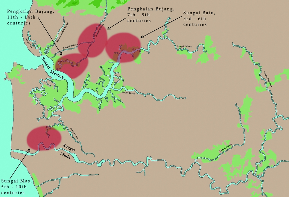
The Bujang Valley spans three rivers, a large estuary, and a bay (Fig. 3).Footnote 19 The two main rivers are the Sungai Merbok and the Sungai Muda, with the Sungai Bujang a tributary of the former. These rivers lie at the foothills of Mount Jerai, a 1,300 metre mountain peak, and drain into the Straits of Melaka. The valley covers an area of about 224 km2 and represents the richest archaeological zone in Malaysia.Footnote 20 The archaeological sites cluster into three main groups. The first is the recently discovered Sungai Batu site, named after the river of the same name. The Sungai Batu River is a tributary of the Sungai Merbok. This site appears to be the earliest in the Bujang Valley region. The second is the Sungai Mas cluster based along the Sungai Muda, while the third is the Pengkalan Bujang cluster on the Sungai Bujang River (Fig. 4).Footnote 21
The Bujang Valley and its main sites. Adapted from Michel Jacq-Hergoualc'h, (2002).

The three main groups of sites in the Bujang Valley and their development over time.

Archaeologically, the entire Bujang Valley area has an occupation sequence of approximately 1,100 years (ca. third – fourteenth centuries). From the outset it appears to have functioned primarily as a coastal trading post which, over time, developed to become the most extensive entrepôt complex on the west coast of the Thai-Malay peninsula. Part of the reason for this can be explained by its favourable bay and estuary, but another important factor was the seasonality of the monsoons, which would have required ships to layover for months at a time as they waited for the winds to change direction. From May to October the Southwest Monsoon blows across the India Ocean. Ships leaving from Sri Lanka or South India would be blown eastwards, making landfall somewhere along the Thai-Malay peninsula. From October to December the Northeast Monsoon blows in the opposite direction allowing ships from China to utilise it on their journeys to Southeast Asia and beyond. The Bujang Valley was therefore one of the most natural stop off points on the west coast. From here, ships could moor before continuing their journeys east or west, and goods could be traded and moved across transpeninsular routes to entrepôts on the Gulf of Thailand such as Langkasuka or Tambralinga.Footnote 22 Its key location and role in this regard was already recognised in seventh century Sui Dynasty, China. In 607 ce, the Sui Court dispatched a major mission bound for Chitu from Guangzhou. Chitu appears to be a phonetic rendering of Kedah, that is, the Bujang Valley. The king of Chitu, who is described in the Sui shu as having hundreds of brahmins at his court in addition to paying reverence to the Buddha, reciprocated and sent two missions to China in 608 and 609 ce respectively.Footnote 23 About seventy years later the Chinese texts refer to the Bujang Valley as Jietu; it is here that the Chinese monk Yijing, after leaving Palembang in South Sumatra, transferred onto a ship to take him to India in approximately 671 ce.Footnote 24 Ninth-century Arab texts also appear to refer to the Bujang Valley, this time as Kalah and Kataha, and again confirm that it was a key port located along the major shipping routes.Footnote 25
The earliest habitation of the valley was based around the Sungai Batu area. Survey and excavations carried out since 2008 by the Centre for Global Archaeological Research, Universiti Sains MalaysiaFootnote 26, has mapped 97 mounds, 10 of which were excavated as of 2010.Footnote 27 Two structures that have come to light, a possible stupa and a jetty, may date as early as the first to second centuries ce while an iron smelting site has been dated to the third to sixth centuries ce.Footnote 28 From the sixth to eleventh centuries the main centre appears to have been based around Sungai Mas, while from the eleventh to fourteenth centuries it shifts to Pengkalan Bujang (Fig. 4).Footnote 29 Explanations as to the cause of this shifting settlement pattern have focused on falling sea levels and changes in the courses of the rivers. As this polity was primarily an entrepôt, access to both the coast and to the highlands via the rivers for sourcing of forest goods for trade was essential to its survival.
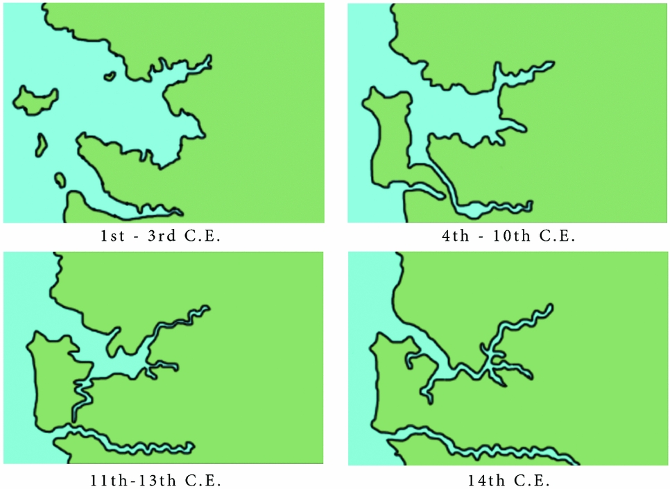
Some of the most important advances in recent years in our understanding of the Bujang Valley come from geological and geophysical mapping, which has enabled a greater reconstruction of the palaeoenvironment.Footnote 30 From these studies, Saidin et al. have established that during the first to third centuries ce the areas around Sungai Mas and Sungai Bujang were either still under sea water or were too swampy to be inhabited. Sungai Batu, on the other hand, was far enough inland to function as a viable port (Fig. 5).Footnote 31 Jane Allen has also carried out geo-archaeological research in an effort to explain the apparently anomalous locations of the sites.Footnote 32 For instance, she points out that today Pengkalan Bujang is located more than 4 km upstream from the Merbok estuary while Sungai Mas is separated from both the coastline and the Sungai Muda by a floodplain more than 4 km wide.Footnote 33 This led her to investigate the rate and extent of coastal progradation and the silting up of the rivers in question. Referencing T. T. Khoo's work, she points out that the Sungai Merbok was never actually a large river.Footnote 34 Instead, what is today's estuary is the remains of a large marine embayment or lagoon which has silted up and reached its current level about 600 years ago (Fig. 5). These results have had significant implications as to the social and political organisation of the polity that existed in the Bujang Valley throughout the centuries (see below).Footnote 35
A reconstruction of the palaeoenvironment of the Bujang Valley. Adapted from Mokhtar Saidin et al., (2011).

Both Saidin et al.’s and Allen's results indicate that the courses of the rivers changed over time and consequently so did the locations of the trade sites.Footnote 36 The rivers and streams became increasingly silted up due to soil erosion caused by over farming on the surrounding hills, and the coastal plain continued to expand outwards. As a result, the trading sites became increasingly landlocked. As the populations at these centres and, correspondingly, agriculture increased, erosion only worsened, making the problem even more severe.Footnote 37 Today Sungai Batu is about 10 km from the Straits of Melaka and 7 km from the Merbok estuary, long ago ceasing to be a viable location for maritime trade. The centre therefore moved towards Sungai Mas until the eleventh century, after which Pengkalan Bujang gained supremacy. By the twelfth to thirteenth centuries, Allen estimates that both Sungai Mas and Pengkalan Bujang's access to the sea would have been blocked off. Pengkalan Bujang subsequently ceased to be viable but Sungai Mas recovered, owing to its location on the Sungai Muda River, which was able to break through the build-up of sandbanks and provide direct access to the sea again.
Greater understanding of the variations in sea levels and river courses has therefore aided in understanding causes behind the changing settlement patterns in the Bujang Valley area. It may also, as Allen suggests, explain apparent discrepancies in ancient maps of the region.Footnote 38 For instance, by stripping away the west coastal plain and geographical features that would not have existed in the early first millennium ce, Allen argues that there is a much larger congruence with Ptolemy's first to second century ce map of the region. The site of Kokkonegara may in fact refer to Sungai Mas or Pengkalan Bujang.Footnote 39 Whether this is the case or not, geoarchaeological research is proving more and more essential in our interpretations of the past.
The Quaritch Wales Excavations
In the winter of 1935–1936, Quaritch Wales conducted the second expedition of the Greater-Indian Research Committee, the primary focus of which was the Dvaravati moated site of Si Thep in central Thailand.Footnote 40 The aforementioned committee was under the auspices of the Greater India Society founded in Calcutta [Kolkata] in 1926 with the aim of investigating and understanding India's “internationalism” and colonisation of Southeast Asia.Footnote 41 It counted among its founding members such luminaries as Rabindranath Tagore and was greatly influenced by the theories of French Sanskrit scholars such as Sylvain Lévi, among others. Quaritch Wales was also a firm proponent of the views on “Indianisation” espoused by the Society. Where others endeavoured to find evidence in support of these theories in terms of linguistics and inscriptions, he turned his attention to the archaeological record.
Quaritch Wales had a lifelong association with Southeast Asia, and Thailand in particular. He spent over fifty years studying the region – he was still researching in Thailand and publishing as late as 1983 – and he penned no less than fourteen books and countless journal articles. One of his earliest works, Siamese State Ceremonies: their history and function published in 1931, continues to be an invaluable resource and has subsequently been reprinted (1992) and digitised (2005). His book on Dvaravati, published in 1969, is, to this day, the only publication in the English language to provide an overview and analysis of the archaeological and art historical evidence for this culture.Footnote 42 The Making of Greater India, published in 1961, was also another significant publication outlining his theory of the process of Indianisation.
Quaritch Wales, however, was a man of his times and, like many of his contemporaries, his archaeological methods were not of the same standards as today. He appears sometimes too eager to jump to conclusions from his archaeological discoveriesFootnote 43 and his interpretations were coloured by his desire to prove his theories of Hindu colonisation. This was very much the case with his approach to the Bujang Valley sites. We must therefore exercise some caution when studying and drawing conclusions from his work. While scholarship over the past fifty years has by and large debunked and disproved his Indianisation theories, this should not undermine the value of his contributions to the field. Today's theories see the process he dedicated his life's research to as much more of an adoption and adaptation of Indian concepts and technologies by Southeast Asians over a long period of time.Footnote 44
Since his trip to Si Thep was curtailed by a prolonged rainy season in late 1935, Quaritch Wales availed himself of this opportunity to carry out excavations in January 1936 at the Dvaravati site of Phong Tuek in Kanchanaburi province, west-central Thailand.Footnote 45 When completed, he subsequently carried out his expedition at Si Thep as planned. On his return from this trip, he approached the Greater-Indian Research Committee about the possibility of carrying out excavations in Malaysia. His rationale was that there was a great lacuna in our knowledge of the region. He stated that this was hampering “progress in the elucidations of the history of South Eastern Asia and of the processes which brought about ancient Indian cultural expansion, the latter being one of the most important civilizing movements in the history of mankind”.Footnote 46 With this grand purpose at the forefront of his mind, he set his sights on the Bujang Valley and its monuments, with the express intention of enlightening humanity to the achievements of Indian culture on Southeast Asian soil.
Over a period of fourteen months from 1936–37, Quaritch Wales and his wife surveyed thirty-one sites in the Bujang Valley and of those, excavated up to twenty-three (Fig. 3).Footnote 47 Dorothy C. Quaritch Wales carried out further survey and excavation work in 1941 while her husband was involved in the war, most significantly on site 16A where a bronze Buddha image was found in situ. The results of these excavations were published in two volumes of the Journal of the Malaysian Branch of the Royal Asiatic Society and, as previously mentioned, the majority of the excavated material was sent to Singapore.Footnote 48 What follows is a discussion of the most significant material and sites that Quaritch Wales investigated, his interpretations of it, and how he employed them to fit his theories of Indianisation.Footnote 49
The sites and their excavated material
Sites 1 and 2
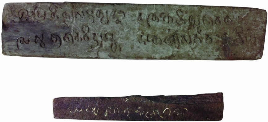
The first site discussed by Quaritch Wales (site 1) is the only one not located within the Bujang Valley proper; it is some 20 km north of Mount Jerai. His excavations uncovered a laterite foundation which he interpreted as a possible base of a stupa, while a few feet to the south he discovered a platform which may have represented the base of a wooden structure, most likely an assembly hall or monks’ residence.Footnote 50 However, of perhaps greater significance was the discovery of an inscribed stone 6.8cm in length in the roots of a nearby tree (Fig. 6). The inscription turned out to be a common Buddhist Ye Dharmā formula. On the strength of Mr. J. Allan's reading and analysis, Quaritch Wales dated it and the site to the fourth century ce.Footnote 51
Two inscriptions found at the Bujang Valley. Top; clay tablet with verse from the Questions of Sagaramati. Bottom; stone tablet with Ye Dharmā formula. Courtesy of the Asian Civilisations Museum.

These views, however, were challenged by Alastair Lamb who consulted both Professor F. D. K. Bosch and Dr J. G. de Casparis, the former assigning an eighth to ninth century date while the latter stated it was clearly ninth century.Footnote 52 As will be shown in discussions below, de Casparis’ dating is more plausible.
Site 2, located about 40 metres to the right bank of the Sungai Bujang River, also revealed an inscription, discovered within the site's laterite foundations. The inscription on a rectangular clay tablet, 13 cm in length (Fig. 6),Footnote 53 was once again read by Allan and also Professor Vogel and Dr N. P. Chakravarti.Footnote 54 It bears three stanzas of a Mahayana Buddhist text known as Questions of Sagaramati which Dr Chakravarti proposed could date no later than the early sixth century. On this basis Quaritch Wales dated Site 2 to that century as well. However, in a recent study, Skilling argues for a seventh to eighth century date, casting doubt on Quaritch Wales’ claims. Skilling also noted that this was the only known citation in South or Southeast Asia of this particular text.Footnote 55 However, in 2007 another such inscription was found at temple Site 32 in the Sungai Mas area by archaeologists at Universiti Sains Malaysia.Footnote 56
As we shall see in more detail below, the dates proposed by Quaritch Wales were integral to his theory that an early Buddhist phase (ca. 300 – 550 ce) was replaced in the mid-sixth century by a Hindu phase brought into the region by Pallava colonists.
Site 4
The discovery of a miniature shrine or reliquary at Site 4 added further grist to Quaritch Wales’ mill regarding his theory of Pallava colonisation.Footnote 57 This miniature shrine was found amongst boulders on the Sungai Bujang River bank, close to Site 4. Made of bronze and measuring 7 cm in height by 10.5 cm in length, it has an open metalwork roof with four crouching figures, one on each of its corners. However, Quaritch Wales’ main interests were the horseshoe-shaped gable windows on either end. These, he noted, closely resemble the roofs on the rock cut Bhima and Ganesa temples at Mahabalipuram in South India. From this he infers that the temple architecture in Bujang must have resembled this style. He proposed this despite uncovering only the foundations of buildings in his excavations. There are reasons to challenge Quaritch Wales's assumptions, not least that the shrine cover was a potentially portable object which could have been brought to Bujang from India. Based on this roof style, he dates the site to the sixth or seventh century.Footnote 58 Again, numerous objections can be raised. For instance, the shrine was not even found at Site 4; therefore, the connection between it and the structure is not certain. Furthermore, as the miniature shrine could have been brought from India, we cannot rule out the possibility that it could have been in use for some time before Site 4 was constructed.
Site 8
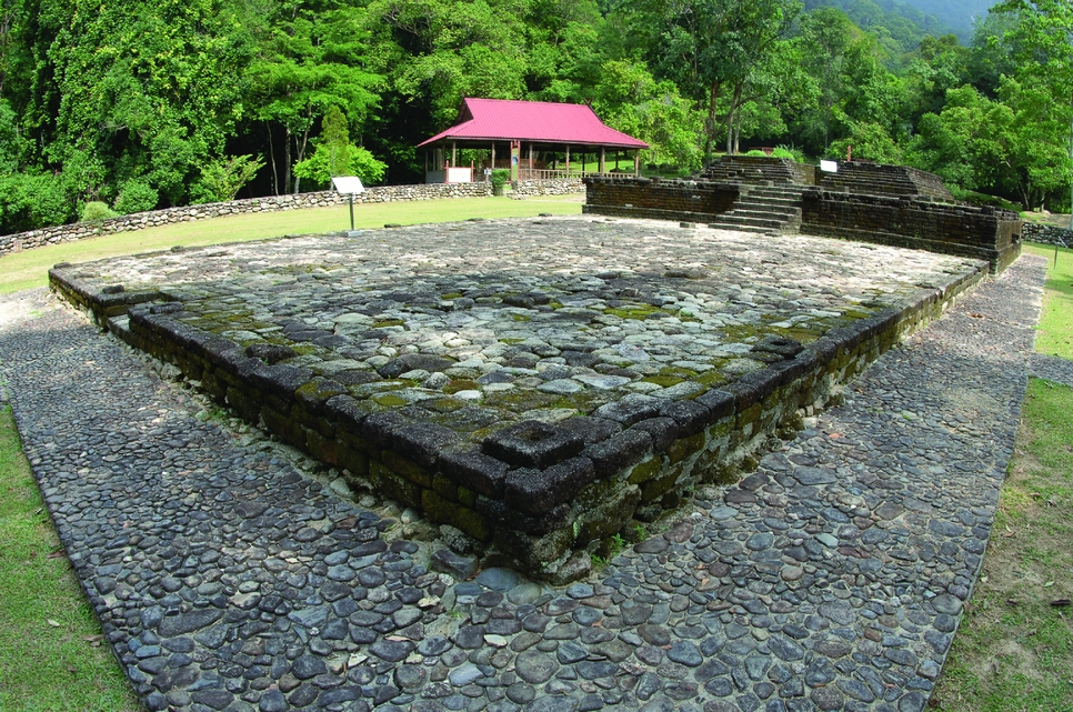
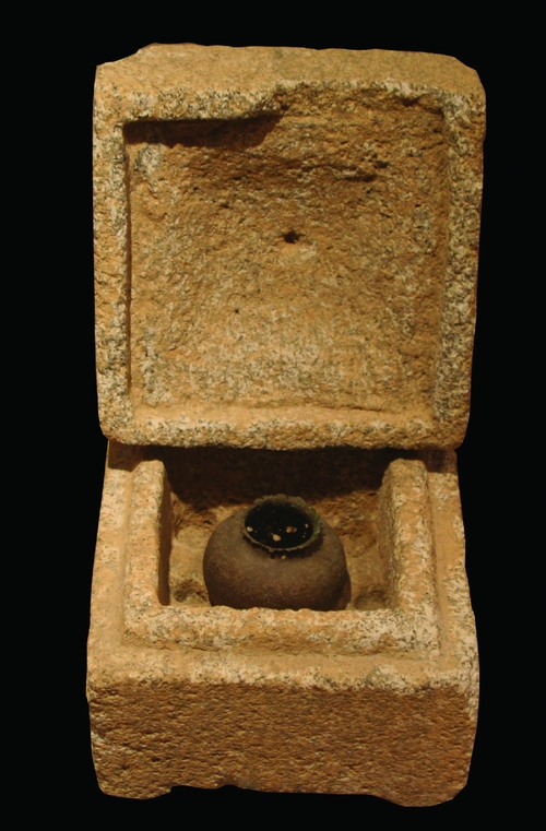
This site, also referred to as Candi Bukit Batu Pahat, lies on the foothills of Mount Jerai (Fig. 7). It has revealed some of the clearest evidence for the tradition of foundation deposits in a Southeast Asian context. Quaritch Wales discovered two nine-chambered stone reliquaries in debris outside of the temple, which he attributed to looting.Footnote 59 However, their contents, unlike the ones excavated by Alastair Lamb some twenty years later (discussed below), did not survive (Fig 8). He did, however, find two in situ foundation deposits consisting of small silver capsules containing one small sapphire and one small polished pyrope apiece, in recesses at the chief socles of the south and west corners of the vimana.Footnote 60 A bronze trident was also discovered along with a broken snana-droni and segments of a somasutra – to Quaritch Wales, these finds indicated that the temple was Saivite in religious orientation.Footnote 61
Site 8, Candi Bukit Batu Pahat. Author's photograph.

Stone reliquary and pot from Site 8. Author's photograph.

Site 10
Quaritch Wales discovered more foundation deposits at Site 10; however, these were Buddhist.Footnote 62 At about 60 cm below floor level he discovered one gold and six silver discs about 3.5cm in diameter. Each is inscribed on one side with writing, which Dr Chakravarti stated were names of bodhisattvas. Chakravarti argues on palaeographic grounds that these date to “a little earlier than the VIII century”.Footnote 63 Professor Bosch, on the other hand, argues for a second half of the ninth century date but concurs with Chakravarti that the inscriptions name various bodhisattvas. Owing to the absence of Chinese ceramics at the site, Quaritch Wales concludes that an eighth or ninth century ce date is the most likely.
Site 12
Site 12 provided Quaritch Wales with some of the clearest evidence for trade contact with China in the Tang period.Footnote 64 This came in the shape of two fragmentary Tang bronze mirrors dating from the ninth to tenth centuries. A fragmentary iron dagger with a bronze hilt was also discovered here. Stylistically, Quaritch Wales sees parallels between it and another dagger worn by the buffalo demon on the Mahisasura Mandapam relief at Mahabalipuram, another element in his Pallava colonisation theory. He also points out this story is represented on the reliefs at Borobodur.
Sites 13 and 14
Both Sites 13 and 14 had reliquary deposits contained in earthenware jars. At Site 13, a jar was placed at each of the four corners of the brick sanctuary. These jars contained mollusc shells and glass beads.Footnote 65 At Site 14, only two earthenware jars of a similar design to those at Site 13 were found. They contained two silver coins of the Abbisid Caliph al-Mutawakil (847-861 ce), one of them, a half-dirham, bears a date of 234 ah (848 ce).Footnote 66 Also found inside was an unreadable silver inscription which appears to be written in Pali, beads and a piece of polished amethystine quartz. Quaritch Wales dates both sites to the eighth to ninth centuries.
Site 16
Along with Sites 8, 10, 13 and 14, Quaritch Wales found further evidence for the tradition of foundation deposits at Site 16.Footnote 67 Here the deposit was contained within a bronze bowl about 12 cm in diameter and 7 cm in height. It was found in a chamber located beside the entrance to the sanctuary, about 65 cm from its base. To make room, one laterite block was left out, leaving a cavity for the reliquary. The contents consisted of miniature animals and weapons, and gems. Quaritch Wales proposed that these were meant to represent the attributes of a bodhisattva, possibly of tantric persuasion. However, Jacq-Hergoualc'h points out that architecturally the site is more likely to be Brahmanical and therefore the deities worshipped here should be as well.Footnote 68
The animals consisted of a gold lion, a silver bull, a copper horse, and a fourth animal which appears to be an elephant. The weapons were a bow with two arrows, a sword, a dagger, a noose, a staff or spear, a shield, and a drum. The gems consisted of amethystine quartz, a polished amethyst, a sapphire, a pearl, and two yellow glass octahedrons most likely made of Arab glass. Also found were a number of bronze objects including a bell, most likely for use in temple ritual, an aureole which presumably belonged to a sculpture of a deity which no longer survives, and two bronze lamps. An iron ring 8 cm in diameter was also discovered. Quaritch Wales dated the site to the ninth to tenth centuries.
Site 16A
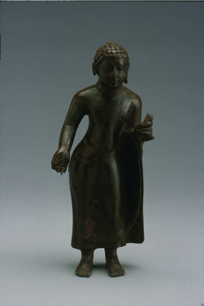
Perhaps the most important discovery ever made at Pengkalan Bujang was not by H.G. Quaritch Wales, but by his wife, Dorothy, who excavated site 16A in 1941 while her husband was involved in the war. At this site, located about 15 metres from Site 16, she found an in situ bronze Buddha image just over 20 cm in height (Fig. 9). Its Gupta characteristics led her to assign it a fifth century date. However, as shall be seen below, this date has been challenged by some scholars.Footnote 69
Buddha image from Site 16A. Courtesy of the Asian Civilisations Museum.

Site 18
While sites such as 16A brought to the fore links with India, and the discovery of Tang mirrors at Site 12 reflects contact with China, the discovery of a fragmentary glass vase at Site 18 provided Quaritch Wales with evidence for trade with the Middle East, most likely Syria. On the basis of the style of architecture and ceramics found at the site (Sung porcelain), he dates Site 18 to the eleventh or twelfth century.Footnote 70
Sites 19, 20–23
Quaritch Wales also investigated these sites and found that Sung dynasty ceramics were common. He dates them to the eleventh or twelfth centuries.Footnote 71
Quaritch Wales's excavations focused primarily on the sites strung along the Bujang River. His analysis of the data was framed within his hypothesis that there were four waves of Indian cultural expansion. This theory had been published in 1936, the same year as his excavations in Kedah.Footnote 72 For him, the Bujang Valley became Indianised during his proposed second wave (300-550 ce) when the prevailing religion was Buddhism. However, the third wave (550-750 ce) brought the arrival of the Hindu Pallava colonists, while the fourth wave (750-900 ce) was still from south India, but with influences from Pala in the north.Footnote 73 Throughout, he emphasised the apparent connections with southern India, from the style of the bronze casket found at Site 16 to the dagger hilt at site 12. He sees connections in as much of the material as possible while at the same time is at great pain to stress the dissimilarity of what he had found with artefacts discovered in Java.
Quaritch Wales's explorations opened up a new chapter in our understanding of not just the archaeology of the Thai-Malay peninsula, but also the nature of trade and contact between Southeast Asia, the Middle East, India, and China. He drew attention to the importance of the sites in the Bujang Valley and paved the way for further research in the area. However, his contentions and interpretations were almost immediately challenged by scholarship from as early as the 1950s onwards. As it shall be discussed below, while many of Quaritch Wales's theories began to be overturned by later scholarship, no doubt was ever cast by these studies on the presence of Buddhism and Hinduism in the Bujang Valley in the first millennium.
Research on the Bujang Valley from the 1950s to the present
Research resumed at the Bujang Valley in 1955–56, initially by faculty from the University of Malaya, and then again in December 1957 and April 1958 under the auspices of the University of Malaya Archaeological Society. The aim was to revisit and build upon Quaritch Wales's excavations.Footnote 74 Limited excavations took place in the 1955–56 seasons while the 1958 expedition focused particularly on Site 8, although it did revisit, to a limited extent, Sites 7, 18, 26 and 28. Site 8 was completely excavated and subsequently reconstructed by Alastair Lamb between 1958–59.Footnote 75 He carried out further survey and excavation work at Pengkalan Bujang in 1961 and paid a visit to the then Raffles Museum, Singapore, to examine Quaritch Wales's excavated material.Footnote 76
Lamb's research led to the first major challenge of Quaritch Wales's interpretations, particularly in terms of dating and the extent of Pallava influence. More detailed analysis of the Chinese ceramics found at Site 8, for instance, indicated that they date to no earlier than the eleventh century, not the eighth to ninth, as Quaritch Wales had suggested.Footnote 77 The miniature shrine roof that Quaritch Wales discovered at Site 4 was dated to the sixth to seventh centuries through comparison with Mahabalipuram. It was also questioned by Lamb, who pointed out that the waggon-roof shape is found throughout India.Footnote 78 Furthermore, comparisons with an incense burner from the Sambas hoard suggests a date of eighth to tenth centuries, thus illustrating that the shrine lid may not be as similar to the Mahabalipuram examples as Quaritch Wales’ suggested.Footnote 79 Lamb's observations undermine both Quaritch Wales's dating and assertions of Pallava influence.
In a similar vein, Lamb also proposed possible Javanese influence, particularly in the nine-chambered reliquaries found at Site 8.Footnote 80 However, Stanley O'Connor and Anna Ślączka have both pointed out that there has been plenty of Indian textual evidence to indicate its origins are in fact from the sub-continent.Footnote 81 O'Connor's review of the evidence not only in Bujang and Java, but also in southern Thailand and the Cham regions of Vietnam, shows that this tradition spread into the various cultures of Southeast Asia. Ślączka, too, argues that Southeast Asians adopted this consecration ritual but cautions that the meanings and significance of these ceremonies may have been altered and adapted to local beliefs and sensitivities.Footnote 82 Either way, there is no reason to think that the tradition found at Site 8 in Bujang came from Java as Lamb suggested.
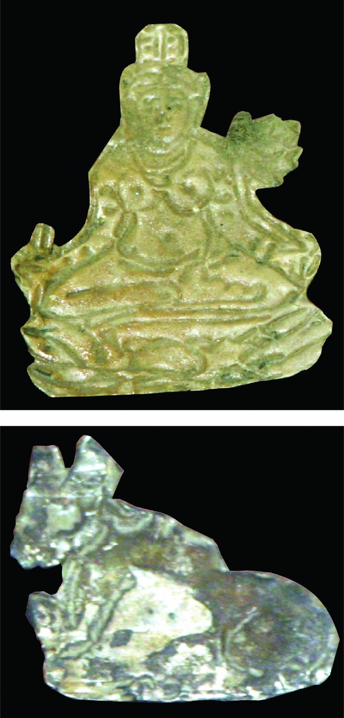
Quaritch Wales had found two reliquaries from Site 8 in his excavations. Lamb, during the course of his, found six more, bringing the total to eight. They were all found within sanctuary walls at floor level, one in each of the four corners and one at each midpoint of the sanctuary walls.Footnote 83 The reliquaries were made from the same stone as the blocks of the temple, which Quaritch Wales referred to as quartzite but Lamb points out is actually granite (Fig. 8). The central depression of each reliquary contained a gold, silver, or copper foil, while the other depressions contained semi-precious stones such as ruby or rock crystal and/or other substances.Footnote 84 The objects in the central depressions were shaped as animals (a turtle and a bull), linga, female figurines, and lotus flowers which confirms the Saivite religious affiliation of the temple (Fig. 10). This was further confirmed by F. E. Treloar's chemical analysis of the objects with some, such as the linga, showing high mercury content; mercury was considered the seed of Siva.Footnote 85
Gold and silver leaf objects found in a reliquary from Site 8. Author's photograph.

Lamb also proposed a new dating sequence for the Bujang Valley. The most significant revision was to Pengkalan Bujang which, based on his reassessment of ceramics, he dated between the eleventh to fourteenth centuries. This ruled out any possibility of Pallava influence in this area of the Bujang Valley.Footnote 86 For Lamb, the first phase of occupation spanned the fourth to fifth centuries and took place on the south bank of the Muda River (viz. Sungai Mas) and was Buddhist. This conclusion was based on the three inscriptions known at that time: the Buddhagupta Stele, the Bukit Meriam inscription, and the stone tablet found by Quatritch Wales at Site 1. Lamb's second period was called the Srivijayan phase with the sites in this group located in the upper reaches of the Bujang river, essentially from Site 16 upwards. The main dates for these sites range from the seventh to ninth centuries. Lamb's third phase in Pengkalan Bujang spanned the eleventh to fourteenth centuries. His work on the Bujang Valley illustrated that the occupational sequences were longer and the cultural influences more complex than Quatritch Wales's assertions of Pallava colonisation.
Both Quaritch Wales and Lamb paid a great deal of attention to the architectural styles of the temples of the Bujang Valley. However, B. A. V. Peacock arguably made the most significant breakthrough in this regard.Footnote 87 Focusing primarily on Site 8, he discussed Lamb's hypothetical reconstruction of Site 8’s central tower.Footnote 88 Finding only a few lower courses during excavations, Lamb had tentatively proposed that it was a stone structure, more than 10 metres in height.Footnote 89 However, Peacock pointed out that neither Lamb nor Quaritch Wales had uncovered large amounts of fallen masonry during their excavations throughout the Bujang Valley. Furthermore, with regard to the hypothetical central tower proposed by Lamb at Site 8, this debris should have been clearly visible. Another major objection was the positioning of stone pillar bases around the structure, clearly designed to support wooden pillars. Following Lamb's reconstruction, Peacock argued they would be architecturally defunct.Footnote 90 The most damning evidence however, came from the foundations themselves which Peacock highlighted were not substantial enough to support the downward thrust of a large scale masonry superstructure.
Instead, Peacock proposed a tower with a wooden superstructure, consisting of multi-tiered roofs similar to those that can still be observed on Javanese buildings today.Footnote 91 This type of structure fits much better with the surviving evidence not only from Site 8, but also from Site 15. The only question in Peacock's mind was the number of tiers that made up the roof. Given that Site 8 was dedicated to Siva, he speculates that it may have been eleven, the number ritually prescribed for this deity. Peacock's reconstruction answered a major architectural quandary faced by both Quaritch Wales and Lamb. In doing so, he too provided further weight to the arguments that the temples of the Bujang Valley were not imported wholesale from Pallava India, but instead represented adaptations of Indian models and forms by Southeast Asian artisans.
With the arrival of Malaysian independence in 1957, the old guard of British colonial archaeologists gradually gave way to a new generation of Malay scholarship. The most prominent Malaysian scholar was Nik Hassan Shuhaimi Nik Abd. Rahman (henceforth Nik Hassan). As well as undertaking excavations of sites in the Bujang Valley, Nik Hassan and the Muzium Negara (National Museum, Kuala Lumpur) carried out reconstructions of eight temples from 1972 until 1981.Footnote 92 These investigations and reconstructions led, in turn, to new finds, particularly in terms of Buddhist sculpture. At Sites 21 and 22 for instance, three terracotta Buddha images, one terracotta bodhisattava, a terracotta elephant, and a bronze bodhisattva were discovered. These finds allowed the researchers to propose a tenth to eleventh century date for the temple.Footnote 93
While Quaritch Wales and Lamb had focussed their attention largely on the area of the Bujang River, in the 1980s Nik Hassan directed his efforts primarily to Sungai Mas/Sungai Muda. Owing to the construction of an irrigation canal that cut through the village of Sungai Mas, ceramic sherds, glass, and beads were uncovered. This led to surveys in the area by Nik Hassan and the National Museum in conjunction with Jane Allen. Six low mounds were investigated.Footnote 94 Three of the most significant finds from these excavations were an inscribed stele depicting a stupa extremely reminiscent to the Buddhagupta stele discovered over 100 years earlier by James Low,Footnote 95 a damaged Buddha head made from green shale stone, and a terracotta image of the goddess Hariti.Footnote 96 They also discovered a votive tablet dated to the seventh century. In total, four excavations took place in the 1980s.
On the basis of his research throughout the 1970s and 80s, Nik Hassan gave a more refined occupational sequence for the Bujang Valley sites. As with Lamb, his conclusions refute Quaritch Wales's proposed chronology and also differ in certain instances from Lamb's.Footnote 97 Nik Hassan's most significant contribution was the confirmation that Sungai Mas was the pre-cursor to Pengkalan Bujang. His excavations show it was primarily Buddhist and that it was active from ca. the fifth to tenth centuries ce. The ceramic evidence from Tang and Song Dynasty China as well as the Persian wares indicate that during the seventh to ninth centuries it still functioned as a major entrepôt. By the end of the ninth or early tenth century, Nik Hassan agrees with Lamb's conclusion that Pengkalan Bujang became the more prominent entrepôt. He also sees the Buddhist phase ending around this time and giving way to Brahmanism, primarily Saivism, as is indicated by sites such as Site no. 8 and those with vimana-mandapa ground plans.Footnote 98
A systematic review of all fifty-two known archaeological sites as of 1991 was undertaken by Michel Jacq-Hergoualc'h. His publication provides plans and elevations for each temple as well as a list of finds.Footnote 99 The majority of sites were constructed primarily of brick, but some, such as Sites 16 and 50, were built of laterite, while Site 8 was built of stone. Architectural features such as stone balustrades with makara designs have also been found to a limited extent; terracotta decorations such as elephants must have lined the facades of the temples.
Jacq-Hergoualc'h divides the structures into three groups, those which can be identified as Buddhist, those which are Brahmanical, and a third group for those which are unidentifiable or unexcavated. In total he lists nine Buddhist monuments, including both temples and stupas, 14 Brahmancial sites, and 17 unidentifiable or unexcavated.Footnote 100 He classified the sites into either Buddhist or Brahmanical based on two criteria: associated finds and the architectural plan of the monument.
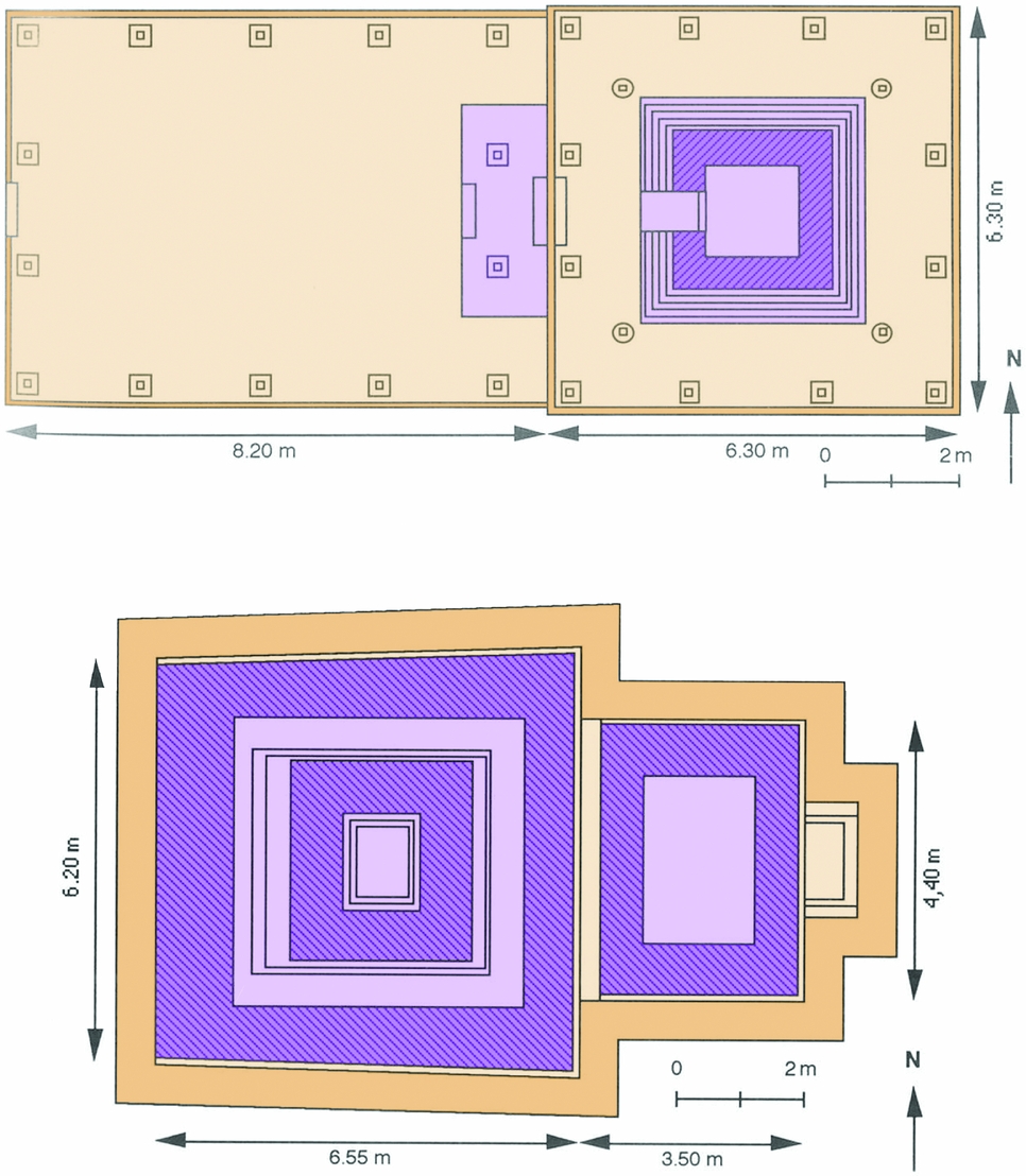
From his excavations Quaritch Wales noted that Brahmanical structures comprised of a single mandapa and vimana. In certain cases snana-droni, linga, and/or somasutras were found associated with the vimana (Fig. 11).Footnote 101 Buddhist sites consisted either of stupas or rectangular structures which may represent assembly halls sometimes referred to as vihara in literature on Southeast Asia. In an Indian context, on the other hand, vihara refers to the entire monastery.
Ground plans of building from Bujang Valley. Top: vihara-type ground plan. Bottom; mandapa and vimana type ground plan. Adapted from Michel Jacq-Hergoualc'h, (1992), figs. 55 & 77.

Jacq-Hergoualc'h’s conclusions differed somewhat from Quaritch Wales's and those proposed by others. He argued there were four areas that existed as entrepôts throughout the Bujang Valley's history:Footnote 102 Kampong Sungai Mas, Pengkalan Bujang (in these first two he is in agreement with Nik Hassan), Kampong Simpor Tambang, and Kampong Sireh.
Kampong Simpor Tambang is located east of Sungai Mas on a tributary of the Sungai Terus known as the Sungai Simpor. The site is identified by the remains of a laterite wall. Jacq-Hergoualc'h argued that this was an entrepôt based on the large quantities of Chinese ceramics dating back to the tenth to thirteenth centuries, in addition to the beads and glass found there, as opposed to extensive remains of monuments.Footnote 103 Allen, who first located the site, suggested it may have functioned as a relay site for Pengkalan Bujang.Footnote 104
Kampong Sireh is located directly east of Kampong Sungai Mas on the Sungai Muda River. Again, the site was identified by the large quantities of ceramics, including Sawankhalok celadon sherds from Thailand dating to the fourteenth to fifteenth centuries, as well as Chinese and Middle East wares from the eleventh to twelfth.Footnote 105 Due to the lack of archaeological research carried out at these two latter areas, their exact nature and functions are still uncertain. However, Jacq-Hergoualc'h’s research highlighted that other areas were also involved in the trade network of the Bujang Valley.
Jacq-Hergoualc'h’s research also included a joint French-Malaysian excavation project of Site 23 which resulted in the opening up of a larger area than had been done in the previous three field seasons, 1986–1988, under the supervision of Nik Hassan.Footnote 106 The quadrangular structure of this monument, 11 x 9 m, aligned southwest-northeast, was unlike others in the Bujang valley. Thus its religious orientation could not be clearly established. Finds of twelfth century Chinese celadons dated the site to this century.
Jacq-Hergoualc'h’s work serves as an invaluable corpus of evidence indicating the extent and religious persuasion of the many extant monuments at the Bujang Valley. With this in mind, the paper now turns to the excavations carried out by the 2008 the Centre for Global Archaeological Research.
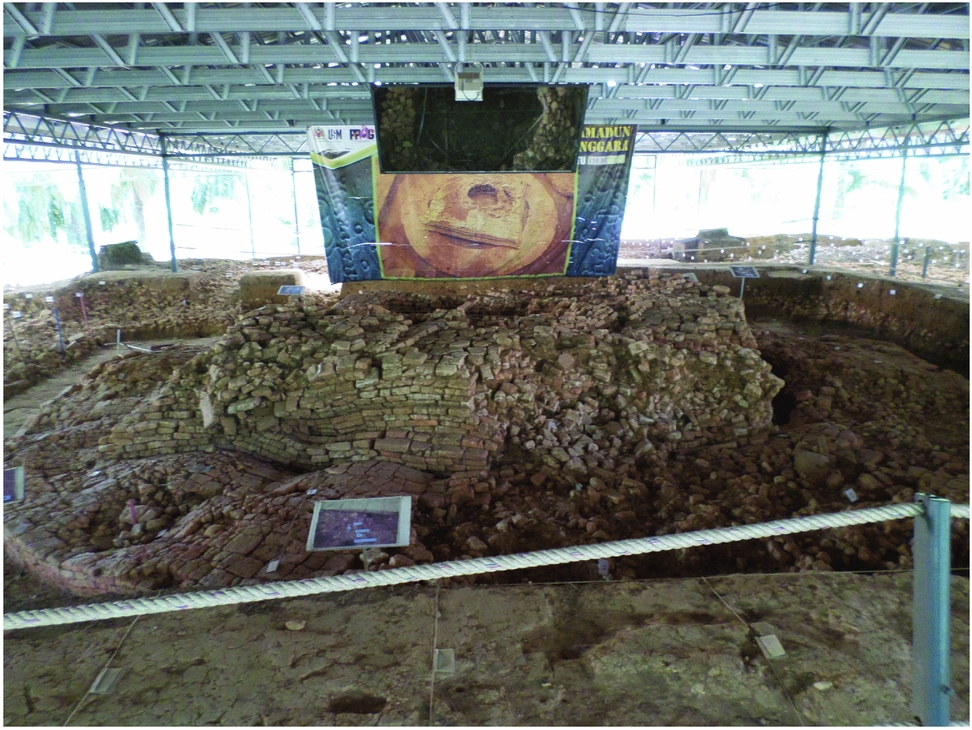
One of most interesting aspects of the new findings at the Sungai Batu site is the range of dates proposed by the excavators for the brick structure SB1B. Based on results of two OSL (Optically stimulated luminescence)Footnote 107 samples, they assessed the structure was 1800 – 1900 years old, giving it a first to second century date.Footnote 108 If correct, this would be the earliest Buddhist structure in Southeast Asia.Footnote 109 Based on its architectural design, a round base surmounted by a square structure, it was most likely a stupa (Fig. 12). Alternatively, it could be that a Hindu structure was built over a previously existing stupa as this architectural form has no precedent anywhere in Southeast Asia. This identification is strengthened by the discovery of a very similar Buddhist stone inscription found by Quaritch Wales at Site 1. This inscription, however, is dated to the sixth to seventh centuries.Footnote 110 Finger-marked bricks were also found, pointing towards Buddhism.
Brick structure SB1B from Sungai Batu, possibly a stupa. Courtesy of Pimchanok Pongkasetkan.

While the inscription was found in the upper layers of the excavation, its presence, coupled with the problem that no other Buddhist monument in Southeast Asia has been dated so early, raises concerns about the claims that this structure is datable to the first century. Professor Saidin has recently shared his interpretations about this issue.Footnote 111 He clarifies that the 2nd century ce OSL dates come from the circular shaped base. However, on top of the circular base is a square structure which is in turn surmounted by round-shaped structures. This latter part is dated to the 6th century ce and its form is clearly that of a stupa. That therefore leaves a difference of approximately 400 years between the bottom ‘stupa’ structure and the top one. It is this discrepancy that has led him to suggest that the round-shaped form at the base dating to the second century may be an animistic monument related to rituals performed for Mount Jerai as it is too early a date for the presence of Buddhism or Hinduism.
Seen in this light, the context of Professor Saidin's statement about the presence of animism becomes clearer as it is an attempt to explain the earlier date. However, it may actually be a simple case of inaccurate OSL dates. One further OSL date from the jetty (SB1A) gave a date of 1740+/- 25 years BP, which would give a mid-third century date. Therefore, at present, we should be cautious of accepting the date of first to third centuries ce based on three OSL dates alone. Instead it would be more prudent to wait for the results of further research and testing.Footnote 112 Excavations at the iron smelting site (SB2A) on the other hand produced a much more robust set of dates obtained from 22 samples using radiocarbon, AMS, and OSL dating. Tellingly they give an occupational sequence of third to sixth centuries followed by a hiatus in human activity for about a century. The site is then active again from the seventh to sixteenth centuries.Footnote 113
The research carried out at Sungai Batu has opened up a new chapter in our understanding of the Bujang Valley. It shows that this area was probably active in trading from ca. third century ce onward and possibly earlier. The jetty, Site SB1A, and the iron smelting Site, SB2A, provide particularly clear evidence in this regard. The large-scale production of iron gives some of the best evidence to date of what types of commodities were traded out of the Bujang Valley.
The Bujang Valley: an extensive entrepôt complex
An assessment of the research carried out to date on the Bujang Valley leads to one very clear conclusion: the area was not home to a “kingdom” or centre of an organised state, but was an extensive entrepôt complex that grew over numerous centuries and adapted and shifted its location over time to counter the effects of the silting of waterways and coastal progradation. A number of factors clearly support this view:
Firstly, Allen's work in particular shows that there was insufficient land to support large scale intensive wet rice farming, a necessary precondition for vertical state development such as at Angkor.Footnote 114 The coastal plain that exists today was not present before ca. 1200 and could therefore not have been used in wet rice farming.Footnote 115 Instead, the inhabitants employed intensive hill slope cultivation, which inevitably led to serious problems with erosion and subsequent landform changes.Footnote 116 Cultivation of hill slopes alone would not have produced sufficient agriculture yields to support a state-level society such as Angkor.Footnote 117
Secondly, an inbuilt flexibility in Bujang Valley social structure resulting from changes in river flow and siltation meant that the entrepôt’s centre or centres had built-in adaptive measures. As conditions became unfavourable in Sungai Batu, for example, the centre shifted to Sungai Mas, after which it moved to Pengkalan Bujang in the tenth to eleventh centuries.
Thirdly, the architectural remains of Bujang Valley are also telling. Over a period of 700 – 900 years (ca. fifth to thirteenth centuries), temples remained essentially small-scale. This is in stark contrast to other Southeast Asian cultures such as Angkor in Cambodia, Bagan in Myanmar, or among the Cham of Vietnam, which over the timescale in question evolved ever more complex and grandiose architectural forms. Likewise in Java we see the creation of Borobudur in the eighth century and Prambanan in the ninth. Nothing coming close to this scale can be observed in the Bujang Valley.
Given its role as an entrepôt complex, it is likely that the temples in the Bujang Valley were sponsored by merchants and tradespeople, both foreign and indigenous. As fortunes, livelihoods, and the lives of the sailors were beholden on the vicissitudes of the oceans and seas, it is only natural that they would seek supernatural assistance to aid them in their endeavours. The Buddhagupta stele was dedicated by a sea captain as thanks for a safe passage. By the fifth century, the cult of Dipankara Buddha (the saviour of seafarers) had become understandably popular among merchants, while, from as early as the fourth century, worship of the bodhisattva Avalokitesvara began to incorporate beliefs that he could offer salvation from the seas.Footnote 118
The placement and distribution of the temples in the Bujang Valley also support this viewpoint. Unlike other Southeast Asian examples where cities were carefully planned and their temples reflected microcosms of the Hindu and Buddhist universes, monumental architecture the Bujang Valley appears to have developed somewhat more organically. Arguments that the entrepôt went through distinctively Buddhist and Hindu phases are also misleading; it seems much more likely that both religions existed to greater or lesser extents throughout the centuries, the primacy or decline of either being likely linked to shifting trade patterns and the religious affiliations of the merchants and traders plying these routes.
Due to its nature as an entrepôt complex, the Bujang Valley was also most likely quite cosmopolitan in character, which again would argue against clearly defined phases of religious affiliation. Comparison with Kollam in Southern India during the ninth century is informative. Kenneth Hall, in his analysis of copper plate inscriptions, shows that Kollam was an administered marketplace run by a Nestorian Christian within a kingdom ruled by a Hindu king.Footnote 119 The inscriptions also mention four Jewish names, eleven Arabic names, and ten Persian names. In the Bujang Valley, we unfortunately do not have any such inscriptional evidence to rely on. However, if the travels of Yijing are anything to go by, then Chinese monks and therefore traders were transiting by at least the seventh century.Footnote 120 The existence of Persian and Arab communities in China by the eighth century,Footnote 121 paired with the ceramics, glass, and numismatic evidence found at Bujang Valley sites, strongly suggest that these ethnic groups, as well as Indians, were stopping here, waiting for both favourable monsoon winds and opportune business transactions.
The objects excavated by Quaritch Wales over seventy years ago should be viewed in the context of this extensive cosmopolitan entrepôt complex. For instance, the miniature shrine cover from Site 4, which for Quaritch Wales spoke of Pallava colonisation, should be viewed as an object most likely brought to the site by a merchant or trader either of South Indian origin, or who had at least sojourned there for some time. Peacock's work on the architecture of the Bujang Valley sites strongly argues against the employment of any Mahabalipuram style roof structures. The stone tablet found at Site 1 and those found recently at Sungai Batu seem to be part of a local tradition of carving the Ye Dharma formula on highly portable objects. Perhaps these were created by local Buddhist monks specifically for sailors who would take them to sea as talismans.
One ritual practice that both Buddhists and Hindus in Bujang shared was that of foundation deposits. The evidence from Sites 8, 10, 13, 14, and 16 shows that this tradition spanned at least four to five centuries, from the eighth century at Site 10 to the eleventh to twelfth centuries at Site 8. Variation in terms of the reliquaries used and objects interred occurs, but the purpose appears consistent. As Ślączka pointed out, the ritual begins with purification of the ground and ends with an abhiseka (ablution) of the whole edifice.Footnote 122 Both O'Connor and Ślączka have shown, contradicting Lamb's claim, that this practice is well documented in India.Footnote 123 Therefore, it most likely arrived in the Bujang Valley as part of the overall set of rituals and ceremonies that the incoming Brahmins and Buddhists brought with them.
The Buddha from Site 16A is another example of how Buddhism established itself within the Bujang Valley. The scholarly consensus is that it is of local manufacture, which suggests that there was a sufficiently large demand for religious paraphernalia to support local artisans. However, there is some disagreement over the date.Footnote 124 In the somewhat clumsy depiction of the robe on the back and sides, Guy sees a local artist struggling to master his subject matter and assigns a sixth century date.Footnote 125 By comparison with sculpture from Nalanda, Heidi Tan interpretes this as artistic licence on the part of the sculptor and assigns it an eighth century date.Footnote 126
Dorothy Quaritch Wales did not assign a date to Site 16A, though she did mention that the brick measurements do not suggest an early one.Footnote 127 Furthermore, its location in Pengkalan Bujang pointed toward an eighth to ninth century date, or perhaps even tenth to eleventh. This raises two possibilities: the Buddha is of eighth to ninth centuries, as Tan proposed, or, alternatively, that the image is sixth century but was in use, presumably under worship at a shrine, for over two to three centuries. The latter explanation is by no means unlikely as many modern examples of religious icons in Southeast Asia have been worshipped over countless generations. In conclusion, it is difficult to say with certainty which period this Buddha image dates from.
The Bujang Valley, Srivijaya, and its wider Southeast Asian context
The Bujang Valley did not exist in isolation. On the contrary, it was a major entrepôt for most, if not all of its history. Since the 1930s, research has progressed significantly in terms of the Thai-Malay peninsula in general. Excavations, surveys, analysis of historical texts, and art historical studies of objects in museum collections have all contributed to advancing our understandings of the region and a clear picture emerges that Buddhism and Hinduism were present on the peninsula from the fifth century onwards. This section looks at the Bujang Valley within this wider geographic and historical context in light of the current research. It does so to reinforce the evidence already presented for the presence of Buddhism and Hinduism in this region as well as the interactions and connections it had with other entrepôts and polities on the peninsula.
Srivijaya
The early scholarship on Southeast Asia tended to see the Buddhist and Brahmanical civilisations that developed from the beginning of the first millennium onwards as kingdoms holding sway over clearly defined territories.Footnote 128 These interpretations arose from both preconceived Western notions of how societies formed and evolved and also from the perceptions of these entities in ancient Chinese texts. Evidence for states such as Srivijaya, Dvaravati, Funan etc. had been gleaned from Chinese annals by sinologists such as Paul Pelliot at the start of the twentieth century.Footnote 129 These texts spoke of Southeast Asian kingdoms and also assigned geographical boundaries to them. However, the Chinese writers compiled these descriptions filtered through their worldview, reflecting the political realities of their own society. It is understandable, therefore, that these early authors conceived these Southeast Asian polities as kingdoms along the lines of what Chinese versions described.
Understandings and interpretations of Srivijaya also fell prey to such assumptions.Footnote 130 However, scholarship over the past forty years or so has largely debunked these overly neat ‘kingdoms’ and, instead, now posits that they were much looser political entities than previously assumed.Footnote 131 There is general consensus that the centre of Srivijaya was based in Palembang, South Sumatra, and rose to prominence between the seventh to ninth centuries. In the eleventh century, it was attacked and defeated in a maritime confrontation by the Cholas of South India, most likely in a battle for control of the sea lanes.Footnote 132 Towards the end of the eleventh century, the locus of power shifted north to Jambi.Footnote 133 Srivijaya's location at Palembang has been established by excavations conducted there over the past thirty plus years as part of a Franco-Indonesian research programme initiated in the 1980s.Footnote 134 Srivijaya is also now understood not to be a maritime empire controlling vast swathes of sea and coastlines, but instead a network of port-cities and entrepôts. Palembang most likely exacted a certain amount of control over ports as far north as Chaiya in southern Thailand and, at times, as far south as West Java, most likely extracting tribute or a form of taxation on trade.Footnote 135 Palembang may also have extended its control through a system of alliances. Hermann Kulke argues, on the basis of his analysis of inscriptions, that there were several centres of political authority based around the royal palace and, similar to O. W. Wolters, sees a mandala structure where influence spread out from the centres (viz. Palembang) in concentric circles.Footnote 136
O'Connor envisioned Srivijaya as an alliance of harbour principalities with a leader based at Palembang, which may have functioned in a similar fashion to the Hanseatic League in the North and Baltic Seas.Footnote 137 Leonard Andaya points out that it would be extremely difficult for anyone leader to exert direct control over any of the coastal polities, as the inhabitants could easily flee inland into the mountains or to any of the surrounding islands. Therefore, a large and permanent military force would be needed to maintain a grip.Footnote 138 Thus, it seems most likely that Srivijaya was a polycentric trading network built around a system of alliances and tribute.
Given the Bujang Valley's prominence as a major entrepôt complex along the west coast of the Thai-Malay peninsula, it was most certainly part of the Srivijaya network. The ceramic assemblages found throughout the area, as well as the glass, beads, and Buddhist and Brahmanical imagery and paraphernalia, illustrate that the Bujang Valley was an active participant in the trade flows between India and China and within Southeast Asia as well. Tansen Sen, building on the work of scholars such as K. N. Chaudhuri, points out that there were interlocking circuits of trade in existence.Footnote 139 Southeast Asia interacted independently with both China and India but was also part of their overlapping trade networks. Furthermore, regional Southeast Asian trade networks would also have existed, with, once again, the Bujang Valley being a key entrepôt. Some of these potential regional networks on the peninsula are now discussed.
The Kinta Valley
While the majority of studies in peninsular Malaysia have focused on the Bujang Valley, a number of other significant finds have been discovered on the peninsula, particularly along the course of the Kinta Valley in Perak. This river system is some 200 kilometres south of Bujang and was the find spot for a number of bronze Buddha and bodhisattva images. For instance, an eight-armed bodhisattva found in 1908 near Bidor is one of the finest Avalokitesvara images ever found in Southeast Asia.Footnote 140 Another bodhisattva, as well as a Buddha image, both dating to the sixth to ninth centuries, were also found within the valley and attest to the presence of this religion in the area.Footnote 141 However, no archaeological settlements have been found within this river valley to date, making it difficult to pinpoint where these pieces may have been produced. The high level of skill required to cast images of this quality indicate that highly trained artisans did operate in the region by this period. Perhaps they moved between this valley and Bujang, offering their skills to potential clients, suggesting a trade or crafts circuit. The discovery at Bujang Valley Site 10 of gold and silver disks inscribed with names of bodhisattvas, as well as the contents of the bronze reliquary from Site 16, which may represent a tantric form of the deity, point towards both the Bujang and Kinta valleys sharing common religious orientations during the sixth to ninth centuries.
Thung Tuk, Khuan Luk Pad, and Khao Nui
In recent years the Thai Fine Arts Department (henceforth FAD) has conducted a number of excavations along the west coast of the peninsula. They include Khao Nui in Trang province and Thung Tuk at the mouth of the Takuapa River, Phang Nga province, approximately 370 and 450 kilometres north of the Bujang Valley, respectively (Fig. 1). The site of Thung Tuk, which Quaritch Wales himself visited in 1935, shares many similarities with the Bujang Valley, albeit on a smaller scale. Furthermore, at the site of Khao Phra Narai some 15 km or so to the south of Thung Tuk, an over life-size Vishnu image as well as two fragmentary images of the Pallava period were discovered. At another site, Khao Phra Noe, just across the river from Thung Tuk, a monumental Vishnu image of the eighth to ninth centuries had been found.Footnote 142
Excavations carried out by the FAD at Thung Tuk in 2003 uncovered eight brick structures averaging 8 x 6 metres in size.Footnote 143 Stone pedestals found at Thung Tuk site 2 show similarities with those found in the Bujang Valley as do a number of terracotta roof tiles. These may indicate that these structures had wooden superstructures.Footnote 144 Chinese ceramics such as Yue and Changsha wares found at the site date it between the eighth to tenth centuries, as do turquoise-glazed Persian ware.Footnote 145 It appears, therefore, that Thung Tuk had a shorter lifespan than the Bujang Valley with its existence most likely due in part to its location as a nodal point for a trans-peninsular route to the Bay of Bandon and Chaiya on the east coast.
One hundred and fifty kilometres to the south, the site of Khuan Luk Pad in Krabi province has turned up evidence of trade in the form of the numerous glass beads. Further south again, the FAD recently excavated the cave site of Khao Nui in Trang province where over 400 Buddhist votive tablets of the seventh to ninth centuries were discovered.Footnote 146 Most bore bodhisattva, stupa, and Buddha images respectively, with the excavators classifying the votive tablets into eight types. This new discovery adds to our knowledge of a number of other cave sites in the region, such as Khao Ok Thalu and Khuha Sawon in Phattalung province, Khao Chum Thong in Nakhon Si Thammarat province, as well as Wat Ham and Wat Phra Phut in Trang, most in relatively close proximity to one another.Footnote 147 The volume of votive tablets found at these sites illustrates the extent to which Mahayana Buddhism had taken hold along this strip of the peninsula.
The sites of Thung Tuk, Khuan Luk Pad, and Khao Nui most likely owe their existence to their locations as nodes on the transpeninsular routes to the Bay of Bandon and also Tambralinga (see below).Footnote 148 However, while these sites flourished particularly between the seventh and tenth centuries, the Bujang Valley appears to have remained the major entrepôt complex on the west coast of the peninsula; these smaller sites possibly acted as stopping off points for ships hugging the coast on their way up or down the peninsula. The similarity in ceramic assemblages from the Tang period found at both Bujang and Thung Tuk as well as some glass fragments clearly indicate they were part of the same trade network.Footnote 149
Tambralinga, Satingphra, and Langkasuka
While the Bujang Valley entrepôt complex was the dominant port of call on the west coast of the peninsula, on the east coast a number of other major polities existed by the fifth to sixth centuries onwards. Most prominent amongst these were Tambralinga, Satingphra, and Langkasuka, all located with good access to both the Gulf of Thailand and the South China Sea as well as the transpeninsular routes to the Andaman Sea.
Tambralinga was located at what is today the modern city of Nakhon Si Thammarat and came into existence as a major coastal polity from the fifth century onwards.Footnote 150 Its religious persuasion was primarily Brahmanical, but Buddhism was also present. There is evidence for both Vaisnaivism and Saivism, the former evidenced by a group of Vishnu images discovered in the area dating from the ca. fifth to seventh centuries.Footnote 151 Saivism is represented in the form of linga, also found within what are understood to be the limits of the Tambralinga polity.Footnote 152 At the site of Khao Kha, Noonsuk has argued that two examples of linga are carved out of the natural rock.Footnote 153 Noonsuk proposed a chronology for Tambralinga as follows: an early Period (fifth to eleventh centuries), a late period (twelve to fourteenth centuries), and the Ayutthaya period (fifteenth to eighteenth centuries). Tambralinga was an active coastal city for much of the same period as the Bujang Valley and both came under the port trading system of Srivijaya from circa the seventh century.Footnote 154 They also display some architectural similarities in the construction of their monuments.
At Khao Kha, in Sichon province, stone bases for pillars were found at many of the brick Brahmanical temples. Furthermore, as with sites at the Bujang Valley, the doorjambs and thresholds were made of stone. Just like the Bujang Valley and at Thung Tuk, a wooden superstructure was the favoured architectural form, supplemented by stone thresholds and doorjambs in certain cases. Transpeninsular routes clearly connected these two ports, perhaps via Sating Phra on the east coast.Footnote 155 Both Bujang and Tambralinga would have functioned as vital nodes on the international trade routes.
Excavations at the site of Sating Phra, 120 kilometres south of Tambralinga, have produced evidence for tradewares stretching from ca. the second to fourteenth centuries.Footnote 156 It has been proposed by Stargardt that this site became a major urban centre from the sixth century onwards supported by wet rice cultivation.Footnote 157 Allen sees the peak period of activity for the site at between the eighth to fourteenth centuries, and that the site location was chosen due to its suitability as a port, its access to the mountains for obtaining tradable forest products, and its position as a node on the transpenisular routes.Footnote 158
The closest coastal port-city to the Bujang Valley is Langkasuka, located in what is today Pattani province of Thailand.Footnote 159 As the crow flies it is about 160 km northeast of the Bujang Valley. Of particular interest is the site of Yarang, also known as the Yarang Archaeological complex, which dates to the sixth to ninth centuries and is considered the possible centre of Langkasuka.Footnote 160 Its inhabitants are thought to have been primarily Buddhist, although lingas have also been found here. Ten kilometres north of Yarang, the site of Ban Bana is primarily Brahmanical.Footnote 161 These sites warrant further investigation as their locations suggest that they were on a direct transpeninsular route connecting them with the Bujang Valley.Footnote 162
By looking at the wider context of the Thai-Malay peninsula, it becomes apparent that the Bujang Valley was part of a system of flourishing trade-based societies and economies operating on both coasts. During certain periods these sites would have come within the orbit of Srivijaya; therefore, international and regional trade and commerce would then have been monopolised by Palembang. However, at other times, particularly from the eleventh to thirteenth centuries when Srivijaya's power waned, the Bujang Valley and sites such as Tambralinga and Langkasuka most likely enjoyed greater autonomy. While much research has been done on these individual sites, the connections between them have not been investigated to any significant degree and may prove to be a very valuable topic of future study.
Conclusion
In the over a century and a half since James Low made his first discoveries in Kedah, our knowledge and understanding of the significance of the Bujang Valley has increased considerably. The excavations of Quaritch Wales represented the first attempt to understand the entrepôt. While his pre-conceived notions about Hindu-Pallava colonists can today be dismissed, his work set in motion the almost continuous archaeological research that has taken place until today. As a result, we now know that this river valley represented the most extensive entrepôt complex on the west coast of the Thai-Malay peninsula for almost a millennium, from the early centuries ce until it was finally supplanted by Melaka in the fourteenth century. Furthermore, it did not exist in isolation, but was part of a web of maritime and transpeninsular trade routes, which linked it not only to sites on the east coast of the peninsula but also to cities and civilisations much further afield. Chinese ceramics, Persian pottery, Arab glass, and Indian religions reflect that the Bujang Valley was a cosmopolitan centre at the heart of maritime trade, located as it was on a key pivot of the route between East and West. In closing, the Bujang Valley should be celebrated as a reflection of Malaysia's cosmopolitan and multicultural history.
Acknowledgements
Research and the writing of this article was undertaken while I was a Research Fellow at the Asian Civilisations Museum, Singapore and I would like to register my appreciation for their support in this endeavour. Also to Arlo Griffith, Peter Skilling and Janice Stargardt for their critical feedback on earlier drafts of this manuscript. The views expressed herein are my own as are any errors or shortcomings.