


Background
The Guildford Fire Station (GFS) site lies within modern Guildford, Surrey (Figure 1; NGR SU 9965 5081), on the left bank of the River Wey a few metres above the floodplain, north of where the river cuts through the chalk ridge of the ‘Hog’s Back’. The Wey is a main tributary of the Thames, navigable from Guildford to its confluence at Weybridge some 25 km downstream.
Setting and topographic location of Guildford Fire Station, Surrey, SE England (© Oxford Archaeology).

Figure 1 Long description
A topographic map of the Guildford area in Surrey, SE England. The map shows the location of Guildford Fire Station, marked with a red circles. Other key locations include Wey Manor Farm, Pyrford, and Brockhill, all marked with black circles. The River Wey is labeled and flows through the area. The map also shows Hog’s Back and North Downs as prominent geographic features. The inset map in the top left corner shows the location of Guildford within England, with major cities like London, Oxford, Birmingham, Manchester, Norwich, Cardiff, and Exeter marked.
Prehistoric flint artefacts at GFS were first recognised in late 20th-century surface collections (Jacobs 2012). In 2013 a large homogeneous scatter of Late Upper Palaeolithic (LUP) flints was discovered during excavations by Oxford Archaeology prior to construction of a new fire station (Barton et al. Reference Barton, Roberts, Tomasso, Rots, Stafford, Hayden and Thacker2024). Over 15,000 lithic artefacts were recovered from c. 36 m2Footnote 1. The assemblage was in exceptionally fresh and unabraded condition, mostly lying horizontally. The high frequency of smaller debitage confirmed minimal postdepositional disturbance.
Two subcircular artefact clusters were identified, each about 2 m2 and about 4 m apart (Figure 2). Both were dominated by blades, rejuvenation pieces, small debitage (<10 mm), cores, and core fragments indicating areas of primary blade production. Of the 235 retouched tools recovered, some came from the area between the clusters, alongside a thin scatter of burnt flint possibly indicating the remains of a hearth. No bone was preserved. The assemblage’s unpatinated, fresh condition made it suitable for use-wear analysis and larger pieces were bagged unwashed to minimise handling before trace-wear and refitting work.
Overall distribution of all artefacts. Those recovered from samples are located randomly within their grid squares (© Oxford Archaeology).

Figure 2 Long description
A plan of the excavated area showing the location of every artefact as a cross, on a 1 m grid lettered A–P from west to east and numbered 1–17 from north to south. Red crosses mark artefacts surveyed on site, and black crosses those recovered through sampling, which are placed randomly within their grid squares. The artefacts form a dense scatter in the centre of the excavation, with two especially dense concentrations: one in the north-west of the scatter (around squares F–G 6–7) and one in the south-east (around squares H–I 11–12). Shaded areas to the west and south show later features and modern truncation, and a red line marks the limit of excavation. The position of Section 1010 is marked to the south-west of the scatter. A north arrow and a 5 m scale bar (1:100) are included.
In this article, we assess the integrity of the flint scatter and identify the presence of a minimum of three flintknappers, including a probable novice, based on extensive lithic analysis, using chaîne opératoire approaches and refitting. Use-wear analysis further identifies a range of activities carried out on or near the site. Taken together, these approaches show how well-preserved sites like GFS can make an important contribution to understanding the Upper Palaeolithic in Britain.
Stratigraphy and dating
The archaeological horizon occurred in fine to medium sands (G2c) separated from similar sands (G2a) by a discontinuous cobble bed (G2b), overlying poorly sorted sandy flint gravels (G1) (Figures 3 and S1). Thin section (Macphail & Crowther Reference Macphail, Crowther, Barton, Roberts, Tomasso, Rots, Stafford, Hayden and Thacker2024) and particle size (Marini Reference Marini, Barton, Roberts, Tomasso, Rots, Stafford, Hayden and Thacker2024) analyses suggest that G2a and G2c were primarily deposited by alluvial processes of an active, likely braided, river channel. The large flint nodules in G2b appear to derive from local Head deposits laid down during periods of peak river discharge. Thin section analysis revealed incipient soil formation in G2c suggesting a stable land surface when the site was occupied. The basal gravels (G1) relate to the Kempsford Park Gravel of Late Devensian age (Bridgland Reference Bridgland1994; Gibbard Reference Gibbard1985; Stafford et al. Reference Stafford, Crowther, Macphail, Marini, Schwenninger, White, Barton, Roberts, Tomasso, Rots, Stafford, Hayden and Thacker2024).
Section 1010 with OSL sample positions (© Oxford Archaeology).

Figure 3 Long description
A drawn section and a photograph of Section 1010. The drawing, at 1:25 with a 1 m scale bar, shows three main stratigraphic units: basal gravel (G1) at the bottom, sand (G2) in the middle, and make-up and topsoil (G3) at the top. The sand is divided by a discontinuous line of cobbles into a lower unit (G2a) and an upper unit (G2c), and the flint scatter lies within G2c. Positions of monolith samples and pollen subsamples are shown. Four OSL samples are marked with numbered orange circles, and their dates are given in the key. The sample from G2c, the archaeological horizon, is dated to 15,105 ± 1715 BP. The photograph shows the excavated section face.
Nine OSL (Optically Stimulated Luminescence) measurements from sediments above, within, and below the archaeological horizon provide the dating framework (Schwenninger Reference Schwenninger, Barton, Roberts, Tomasso, Rots, Stafford, Hayden and Thacker2024) (Figure 4). The archaeological horizon (G2c) yielded an age of 15,105 ± 1715 BP (absolute years), sealed by upper sands dated to 10,150 ± 915 BP. Underlying sands (G2a) provided estimates of 20,345 ± 1475 BP and 19,880 ± 1020 BP, indicating aggradation ceased towards the end of the Last Glacial Maximum. Together with the assemblage’s typological and technological characteristics, these dates are consistent with occupation during the first half of the Windermere Interstadial, roughly equivalent to the Late Bølling oscillation (Hughes et al. Reference Hughes, Clark, Gibbard, Glasser, Tomkins, Palacios, Hughes, García-Ruiz and Andrés2023; Naudinot et al. Reference Naudinot, Fagnart, Langlais, Mevel and Valentin2019; Walker et al. Reference Walker, Coope, Sheldrick, Turney, Lowe, Blockley and Harkness2003).
Summary of OSL date ranges (© Oxford Archaeology).

Figure 4 Long description
A chart of OSL dates for seven sediment samples from Sections 1010 and 1011, each shown as a central point with a horizontal bar for its date range, plotted against years BP (2018) from 8000 to 26,000. Shaded bands mark the Holocene and the Windermere Interstadial, and the Loch Lomond Stadial and Dimlington Stadial are labelled. The samples are arranged by stratigraphic unit, from G1 gravel at the bottom (oldest) through G2a lower sand, G2b cobble layer and G2c upper sand to G2d sandy subsoil at the top (youngest). The G2c sample from the archaeological horizon in Section 1010 overlaps the Windermere Interstadial. Samples <55> and <59> are excluded.
Site formation processes
Various taphonomic analyses tested the in situ nature of the flint scatter (cf. Pope Reference Pope2002). Size-class distribution, artefact fabric, vertical and horizontal distributions, and refit orientations were all examined to assess postdepositional disturbance and the implications for interpreting human activities (Hayden Reference Hayden, Barton, Roberts, Tomasso, Rots, Stafford, Hayden and Thacker2024).
A key question was whether the LUP flint scatter had been disturbed by postdepositional processes such as overbank flooding. Size-class distribution results were consistent with experimentally generated knapping debris (Bertran et al. Reference Bertran, Lenoble, Todisco, Desrosiers and Sørensen2012; Schick Reference Schick1986), with all size classes represented in expected proportions. This indicates that even the smallest debitage (<10 mm) had not been significantly moved by postdepositional processes. Artefact fabric analysis (orientation and dip) tested for hydraulic processes, bioturbation, shrink-swell, or frost heave (Bertran & Lenoble Reference Bertran and Lenoble2002; Bertran & Texier Reference Bertran and Texier1995; Lenoble & Bertran Reference Lenoble and Bertran2004). Most flint lay flat with few pieces at angles over 45°. The strongly planar distribution with random orientation patterns suggests no disturbance from fluvial activity, debris flows, or solifluction (Hayden Reference Hayden, Barton, Roberts, Tomasso, Rots, Stafford, Hayden and Thacker2024).
Vertical distribution analysis across the scatter shows the flints occurred within a narrow band (Figure 5). The majority (95%) covered a 19 cm vertical spread, with 50% concentrated within 5 cm. No significant size sorting was evident and refitting artefacts occurred at similar depths (mean difference 4 cm). Statistical tests on refitting orientations (cf. De la Torre et al. Reference De la Torre, Vanwezer, Benito-Calvo, Proffitt and Mora2019) showed no significant deviation from uniform distribution in larger refit groups, consistent with fabric analysis and minimal postdepositional disturbance. The vertical displacement probably results from trampling and minor bioturbation from earthworm and root activity.
Refits projected onto a north–south aligned section showing the vertical distribution of refitting artefacts. The y-axis (depth) has been exaggerated by a factor of 5 in relation to the x-axis (northing) (© Oxford Archaeology).

Figure 5 Long description
A scatter plot of refitting artefacts projected onto a north–south section, with northing (m) on the horizontal axis and depth (m) from 30.5 to 32.0 on the vertical axis. The vertical scale is exaggerated five times relative to the horizontal. Each artefact is shown as a black dot, and red lines join pieces that refit. Most artefacts lie within a narrow horizontal band between about 31.1 and 31.4 m, and the refit lines run mainly horizontally, linking pieces at similar depths. Only a few scattered pieces lie above or below the main band.
Hotspot and centroid analyses confirm that the artefact distribution retains the expected characteristics of in situ knapping scatters (Hayden Reference Hayden, Barton, Roberts, Tomasso, Rots, Stafford, Hayden and Thacker2024) (Figure 6). Flint artefacts were concentrated in two zones about 4 m apart, representing contemporary knapping clusters. Densities peaked within areas 60–80 cm across, declining rapidly beyond. The smallest pieces were densest in the two main concentrations, consistent with minimal dispersal of knapping debris. Centroid analysis shows most refitting pieces lay close to each other, although some were dispersed up to 6 m, probably through human activity.
Heatmap of all flint artefacts (© Oxford Archaeology).

Figure 6 Long description
A heat map of the density of all flint artefacts, with individual artefacts shown as small dots. The colour scale runs from blue (low density) through green and yellow to red (high density). There are two distinct high-density clusters about 4 m apart, one to the north-west and one to the south-east, and the south-eastern cluster is the denser. Grey lines join refitting artefacts, mostly within and around the clusters and across the area between them. A red line marks the limit of excavation. A north arrow and a 5 m scale bar (1:100) are included.
In summary, the taphonomic and stratigraphic analyses demonstrate that the GFS flint scatter represents a well-preserved in situ LUP occupation with minimal postdepositional disturbance. The constrained stratigraphic context within G2c, with incipient soil formation indicating a stable land surface at the time of occupation, combined with the fabric analysis, tight vertical distribution, high refit rates, and consistent artefact condition, is consistent with a single short-term occupation episode.
Lithic artefact assemblage
A chaîne opératoire analysis based on techno-typological categorisation and assessment of diagnostic pieces (Barton Reference Barton1992; Pelegrin Reference Pelegrin, Valentin, Bodu and Christensen2000; Pelegrin et al. Reference Pelegrin, Karlin and Bodu1988) was supported by refitting and use-wear analysis, allowing consideration of activities from raw material procurement and blade production to tool use and discard. Despite the absence of animal bone, site activities and broader mobility patterns could be inferred. The assemblage is technologically and typologically consistent throughout, supporting the evidence for a single occupation episode. Full details can be found in Nick Barton and colleagues (Reference Barton, Roberts, Tomasso, Rots, Stafford, Hayden and Thacker2024).
Utilised raw material
High-quality, semi-translucent grey-black Cretaceous flint with chalky cortex dominates the assemblage and is available locally in alluvial and colluvial contexts. The nearest primary sources lie c. 800 m north, although the Seaford Chalk Member (about 2 km south) is considered the most likely provenance. Some of the best-quality flint has reddish veins and comprises less than 1% of the assemblage, but 14% of retouched tools. Only one small core displays ‘chattermarks’ typical of river-gravel flint, consistent with the underlying cobble layer (G2b), though most flint from this deposit was too fissured for knapping.
Debitage and blade production
Debitage was classified using standard attributes for describing LUP assemblages in England and Wales (Barton Reference Barton1986; Reference Barton1992) (Table 1). The knapping objective was to produce fairly long, regular blades, as well as small straight blades. Three of the seven blade cores have opposed platforms, with one platform used preferentially for blade removals. These cores appear to have been abandoned at similar stages, often with small blades as the last removals. No diagnostic bladelet cores were identified and cores show few bladelet-proportion scars. There are 57 crested pieces, which evidence the reshaping and preparation of core faces, and 128 core rejuvenation pieces, most of which reflect platform adjustments during blade production.
Assemblage composition (artefact class by number and percentage). Not including natural and post-Palaeolithic objects

Table 1 Long description
A table of the lithic assemblage by artefact class, with three columns: number (n), percentage (%), and percentage excluding small debitage. The nine artefact classes are cores and core fragments; core rejuvenation and crested pieces; unretouched blades and blade fragments; unretouched bladelets and bladelet fragments; unretouched flakes and flake fragments; knapping debris (irregular waste); small debitage and chips; retouched tools, tool fragments and tool debitage; and unclassified. The total is 15,358 artefacts, or 4354 excluding small debitage. A footnote explains that six tools made on core rejuvenation or crested pieces are counted in both categories.
*Six tools were made on core rejuvenation (2) or crested (4) pieces and have also been counted in the tools category.
The assemblage contains 755 blades and fragments, 22% retouched or utilised. Most lacked cortex (72%), consistent with plein débitage. Butts were mainly plain or linear (57%), with significant faceted or dihedral forms (25.5%), 16 of the latter showing en éperon-related platform isolation (Figures 7–8)Footnote 2, about half occurring on well-made, slightly curved blades produced with soft organic hammers, six of which were tools. Platform abrasion on 59% of blades also indicates careful preparation. Blades were mainly detached with soft stone (72%) or soft organic hammers (19%)Footnote 3, with soft stone correlating with mainly straight profiles (59%).
En éperon butt features on a blade from La Madeleine, France (Ashmolean Museum AN1927.281.a), and related examples from Guildford Fire Station (c.921, c.295) (© Ashmolean Museum, University of Oxford).

Figure 7 Long description
A photograph, against a black background with a 10 mm scale bar, of the proximal ends of three blades arranged in three rows. The top row shows a blade from La Madeleine, France, with an en éperon butt. The two lower rows show two blades from Guildford Fire Station (c.921 and c.295) with related en éperon-like butts. Each blade is shown in four views, two faces and two profiles, with a view of the butt (striking platform) above.
Single platform blade core (c.945) and blade debitage with isolated en éperon-like platforms (c.921/c.989/c.988; c.295), linear platform (c.147), large plain platform (c.1709), and punctiform platform (c.4201) (© Oxford Archaeology).

Figure 8 Long description
A plate of line drawings, with a 2 cm scale bar, of a blade core and five blades. On the left is a single-platform blade core (c.945), shown with a view of its striking platform above. The blades are shown with cross-sections and, for most, a view of the butt (striking platform) below. They are a refitted blade (c.921/c.989/c.988) and a blade (c.295), both with isolated en éperon-like platforms; a blade with a linear platform (c.147); a blade with a large plain platform (c.1709); and a refitted blade with a punctiform platform (c.4201/c.963).
The assemblage contains 566 bladelets (width <12 mm, reduced to <9 mm when backed), mostly broken fragments. Their small dimensions and the lack of bladelet cores suggest bladelet production was a byproduct of core maintenance. Bladelets lack regular form and their distribution indicates minimal movement from knapping locations.
Of 2289 flakes, 1390 were complete or rejoined from refits, with 21 modified into tools. Dimensions varied widely, reflecting production at different stages of core preparation, reduction, and maintenance. A further 11,004 small debitage pieces (<10 mm), including chips (<5mm), were recovered, consistent with on-site knapping.
Retouched tool assemblage
A total of 235 retouched tools were identified, excluding tool debitage (44 burin spalls, ten retouch flakes). Tools were subdivided into ‘formal tools’ and miscellaneous retouched pieces (Table 2), with 76% of formal tools on blades. The miscellaneous category includes 48 examples with substantial ‘edge damage’, though this is subjective as such damage could result from knapping, trampling, or deliberate use.
Retouched tools, including retouched tool debitage

Table 2 Long description
A table of retouched tools and retouched tool debitage, with two columns: retouched tool category and number (n). The tool categories are end-scrapers (10), piercers/perforators (7), burins (36), truncations (7), backed blade/lets and points (20), notches and denticulates (26) and rubbed end tools (2). Under the heading ‘Miscellaneous retouched blade/lets and flakes’ are blades with rasante (scalar) retouch (10), retouched blade/lets and flakes (46), blade/lets with fine retouch (23) and edge-damaged blades and flakes (48). The total excluding tool debitage is 235. Under the heading ‘Retouched tool debitage’ are burin spalls (44), tool retouch flakes (10) and a microburin (1). The total including retouched tool debitage is 290.
End-scrapers
Ten end-scrapers (Figures S2–S3) were identified, six complete or rejoined from refitting fragments. Seven are simple end-scrapers, with two short end-scrapers (grattoirs courts) and one double end-scraper. Two display invasive stepped rasante retouch (Bodu & Mevel Reference Bodu and Mevel2008; Jacquier & Naudinot Reference Jacquier and Naudinot2015), also present on ten other formal tools and ten blades. Scraper edges are formed by direct semi-abrupt retouch (Tixier et al. Reference Tixier, Inizan and Roche1980) at angles mainly between 40° and 70°, occasionally more abrupt from resharpening (Figure S2, c.1625, c.2474). Use-wear traces occur on several scrapers but only one (c.485) shows visible edge rounding.
Piercers/perforators
Six small piercers and one perforator were recorded (Figure S4). All but one have distal retouched tips following the blank’s central axis but varying in size.
Burins
Burins (Figures S5–S6) are the most numerous tool class (36), dominated by dihedral (12) and truncation types (9) (Table 3). All but one are on blades, with fairly short supports, and burin edges are usually simple with only four having three or more facets. Most burins (30) have no cortex or only minimal amounts, indicating manufacture on plein débitage blanks. Four dihedral burins display rasante lateral retouch (e.g. Figure S5, c.1204/c.9277), as do two truncation burins on substantial blades (Figure S3, c.19, 107 mm; Figure S5, c.990/c.992, 130 mm) and two other burins (one on a break and one unclassified). Six burins are on breaks, assumed deliberately snapped although lacking diagnostic features of intentional fracture (cf. Barton et al. Reference Barton, Bergman, Collcutt and Morris1983).
Burin typology

Table 3 Long description
A table of burin types, with two columns: typological category and number (n). The categories are dihedral asymmetrical burin (7), dihedral symmetrical burin (5), burin on an oblique truncation (5), burin on a concave/other truncation (4), double burin (2), transverse burin (2), burin on a break (6), burin on a natural surface (1), burin on a notch (2) and unidentified/broken (2). The total is 36.
Backed material
There are 20 backed tools, mainly on blades with direct semi-abrupt or abrupt backing retouch, all showing breakage (Figure 9; Table 4). Types include curve-backed points, straight-backed blade/lets, oblique points, broken fragments and four Krukowski microburins (two refitting) representing accidental breaks during backing. A proximal microburin with a faceted and isolated butt was also found. The most complete backed tool is a curve-backed bi-point (41 × 11 × 3.2 mm) with one tip missing, probably from projectile use (Tomasso & Rots Reference Tomasso, Rots, Barton, Roberts, Tomasso, Rots, Stafford, Hayden and Thacker2024). The small size of the missing portion makes it unlikely to represent any other backed point type, such as a penknife point or curved and angle-backed piece. Two proximal blade portions with curved backing (c.508, c.7482) are likely similar types. Five oblique points and fragments, possibly incomplete parts of larger tools, all have distal retouch and straight profiles. Four backed tools are burnt: three backed blade fragments (two conjoining: c.4322, c.4328) and one curve-backed tip (c.7482). Although breakages may result from thermal fracture, the unburnt backed pieces show equally high breakage incidence. In situ production is attested by a refit between a broken backed point and an overlying blade (Figure S7, RG 43), and by the Krukowski and proximal microburins.
Backed blades, bladelets, and points. Oblique points (c.2378, c.4200, c.694, c.5787, c.5032); curve-backed bi-point (c.308); curve-backed point (c.7482, c.508); straight-backed bladelet with oblique truncation (c.948); backed blade fragments (c.4322/c.4328, c.4062, c.4486); partially backed and truncated blade (c.4735); two refitting Krukowski microburins (c.1732, c.4743); proximal microburin (c.7412) (© Oxford Archaeology).

Figure 9 Long description
A plate of line drawings, with a 2 cm scale bar, of backed tools and microburins, each shown in face and profile views with cross-sections. They are five oblique points (c.2378, c.4200, c.694, c.5787, c.5032); a curve-backed bi-point (c.308); two curve-backed points (c.7482, c.508); a straight-backed bladelet with oblique truncation (c.948); backed blade fragments (c.4322/c.4328, c.4062, c.4486); a partially backed and truncated blade (c.4735); two refitting Krukowski microburins (c.1732, c.4743); and a proximal microburin (c.7412).
Backed tools and fragments

Table 4 Long description
A table of backed tools and fragments, with two columns: backed tool type and number (n). The types are curve-backed point (bi-point) (1), curve-backed point fragment (2), straight-backed bladelet fragment with oblique truncation (1), oblique point (1), oblique point fragment (4), partially backed blade with proximal truncation (1), backed blade fragment (5), backed fragment of bladelet width (1) and Krukowski microburin (4). The total is 20.
Other tools
Seven truncations comprise straight (4) and oblique (3) forms, all but one on blades (Figure S8). There are 22 notches and four denticulates (Figure S9), including single- and double-notched forms on both blades and flakes. Two rubbed end pieces – a patinated blade and a broken blade with a heavily abraded distal end (Figure 10) – were identified as strike-a-lights (cf. Stapert & Johansen Reference Stapert and Johansen1999). Similar rubbing occurs on an end-scraper’s distal arête (c.1315).
Detail of rubbed end ‘strike-a-light’ (c.2555) showing a) macroscopic picture of the distal part of the blade (12.5×); b) microscopic detail of the used edge with intense rounding and striations (100×) (© Oxford Archaeology).

Figure 10 Long description
Photographs and micrographs of a blade used as a strike-a-light (c.2555). At the top, against a black background, the blade is shown in side view with a 36 mm scale bar, alongside an enlarged detail of its tip in the same view. Below, a photograph of the distal end of the blade, with a 1 cm scale bar, has its rubbed tip outlined by a box. This area is enlarged in panel a, a macroscopic view at 12.5× magnification with a 1 mm scale bar. A smaller boxed area within panel a is enlarged in panel b, a micrograph at 100× magnification with a 200 μm scale bar, which shows intense rounding and striations on the used edge.
Miscellaneous retouched
Ten blades display rasante retouch characterised by distinctive flat, stepped, and scaled retouch on one or both lateral margins (Figure 11). Identical retouch occurs on 12 formal tools (see above), and some of these blade fragments refit those tools. Blades with similar retouch, described as ‘une retouche rasante’, have been identified in the French Early Azilian of the Paris Basin, interpreted as deliberate resharpening of the edge (Bodu & Mevel Reference Bodu and Mevel2008; Jacquier & Naudinot Reference Jacquier and Naudinot2015). A further 46 retouched blades, bladelets, and flakes display discontinuous semi-abrupt or abrupt retouch on one or more edges but do not fit easily into the other tool categories. Another 20 blades and three flakes have discontinuous fine marginal retouch, some possibly spontaneous (cf. Newcomer Reference Newcomer and Engelen1976), others associated with utilisation damage. Forty-eight artefacts display significant edge damage possibly representing utilised tools based on experimental observations.
Blade tools with rasante (scalar) retouch: dihedral burin (c.1204), end-scraper (c.2471), rasante retouched blade (c.992, the proximal part of truncation burin c.990) (© Oxford Archaeology).

Figure 11 Long description
A plate of photographs of three blade tools with rasante (scalar) retouch, each shown against a black background with a scale bar. A dihedral burin (c.1204, 67 mm) is shown in dorsal and side views. An end-scraper (c.2471, 92 mm) is shown in dorsal, side and ventral views, with an enlarged detail of the retouched edge. A refitting rasante retouched blade (c.992) and truncation burin (c.990)(139 mm), are shown dorsal and side views, with an enlarged detail of the retouched edge.
Retouched tool debitage
Burin spalls
A possible 44 burin spalls were recognised, 12 refitting to burins, confirming them as byproducts of the burin blow technique. Primary and secondary spalls occur in roughly equal numbers. Eight spalls showed damage or retouch incurred before detachment.
Microburins
Although normally associated with Mesolithic technology, one large proximal microburin (14 × 10.8 × 3.3 mm) with a faceted butt was found within the LUP horizon in fresh, unpatinated condition. Similar artefacts occur in Early Hamburgian sites (Weber Reference Weber2012) and other British LUP contexts (see below).
Functional analysis
In advance of the other analyses, 237 artefacts were studied for use wear at TraceoLab, Liège, using Zeiss stereomicroscopy (8–180×) and metallographic microscopy (50–1000×) (full methodology in Tomasso & Rots Reference Tomasso, Rots, Barton, Roberts, Tomasso, Rots, Stafford, Hayden and Thacker2024).
Examined artefacts included retouched tools, tool waste, and blades with visible edge damage. Although superficially fresh, 147 pieces (62%) were rejected for reflected-light observations due to mechanical (abrasion, friction; Bordes Reference Bordes1950; Levi-Sala Reference Levi-Sala1986; Schutt Reference Schutt, Biella and Chapman1979) or chemical alterations (gloss, patina; Plisson & Mauger Reference Plisson and Mauger1988). In these cases, analysis was restricted to stereomicroscopy, allowing only determination of worked material hardness. The same applied to heat-altered tools. Positive results were obtained on about 80 artefacts, with interpretation aided by TraceoLab’s extensive reference collection of experimental lithic tools (Rots Reference Rots2021). A small-scale experiment tested ambiguous wear traces using experimental retouched blades for cutting hide and leather, and sawing dry wood and bone. While exact reproduction of the archaeological wear traces proved impossible, several hypotheses could be dismissed.
Residues of plant tissue and relatively frequent iron oxide traces were observed on some artefacts and confirmed by elemental analysis using Scanning Electron Microscopy (SEM-EDS). These were mainly of taphonomic origin, except perhaps for a piercer (c.99/143) where plant residue was associated with edge wear (Tomasso & Rots Reference Tomasso, Rots, Barton, Roberts, Tomasso, Rots, Stafford, Hayden and Thacker2024, 154). Analysed tools were divided into subsistence-related (hunting, butchering) and manufacturing/maintenance activities (woodworking, hide working, bone/antler working), with results organised by typological category. Confidence levels were scored from one (low) to four (certain) (Tomasso & Rots Reference Tomasso, Rots, Barton, Roberts, Tomasso, Rots, Stafford, Hayden and Thacker2024).
Interpretation of tools in the subsistence-related category
Nine backed and two unretouched blades and bladelets were classified as potential projectiles based on fracture patterns and wear features. Characteristic damage included tip bending fractures with step-fissured or hinge terminations. Lateral edge damage included concentrations of bifacial or unifacial scars with abrupt and fissured terminations oriented parallel or slightly oblique to the edge. In five cases, macroscopic edge damage was associated with microscopic linear impact traces (MLITs) oriented parallel or slightly oblique to the edge (Figures 12 and S10). Wear patterns suggest mounting as tips or lateral barbs. Several backed pieces also showed basal damage, including proximal bending fractures and small burinations along edges from counter-pressure, typically caused by compression or flexion on impact. Little evidence of butchery emerged from the analysis. However, some blades and blade tools display wear and retouch patterns consistent with episodic resharpening termed rasante retouch. Some of these tools revealed complex life cycles, making it hard to ascertain each stage of use or whether this involved multiple tasks on different materials. In other artefacts, lateral edges sometimes showed rounding and polish perpendicular to the edge, suggesting transverse motion possibly in shaving or cutting hides. Alternatively, striations parallel to the lateral edge in some pieces may indicate repeated insertion in a leather sheath. At Early Azilian sites, similar rasante retouch has been compared to butchery knives (Bodu & Mevel Reference Bodu and Mevel2008; Jacquier pers comm.), leaving open whether some GFS blades were used in processing and butchery.
Backed blade c.4486. a) detail of the distal edge damage: distal and lateral bending fractures (20×); b) detail of the distal edge damage associated with MLITs (25×) (© Oxford Archaeology).

Figure 12 Long description
Photographs of a backed blade fragment (c.4486) showing impact damage. In the lower row, the fragment is shown from both faces, each with a 2 mm scale bar, and white arrows mark areas of damage. A boxed area on each view is enlarged in the upper row. Panel a (20× magnification) shows bending fractures on the distal and lateral edges. Panel b (25× magnification, 1 mm scale bar) shows damage at the distal end associated with microscopic linear impact traces (MLITs).
Interpretation of tools in manufacturing or maintenance activities
End-scrapers are traditionally regarded as hide-working tools, although wear intensity and type depend on use duration, motion, pressure, processing stage, and hide positioning (Keeley Reference Keeley1980). At GFS, explicit use wear occurred on eight of ten end-scrapers, predominantly for processing dry or moistened (as opposed to fresh) hide. One scraper (c.2471) showed possible butchering evidence on lateral edges (Figure 13). Active parts of the tools were mostly scraper ends with use wear often cut by resharpening removals, attesting prolonged use. Scraper blanks were often slightly curved with concave ventral surfaces creating a hooked profile ideal for hide working. The more robust scrapers were used with considerable pressure on dry and moistened hides, while those on long regular blades were probably for final processing of dry hide. At least two scrapers (c.924, c.485) broke while hafted. One scraper on a long blade may have been used with leather wrapped around it.
End-scraper on blade with rasante (scalar) retouch c.2471 with a) rounding from use, distal end (200×); b) scarring, proximal left edge (12.5×); c) microscopic detail of the lateral edge with rounding and polish (200×); d) microscopic detail of the lateral edge with striations (500×) (© Oxford Archaeology).

Figure 13 Long description
A central photograph of an end-scraper on a blade with rasante retouch (c.2471), with a 1 cm scale bar, has four boxed areas, labelled a -d, that are enlarged in the surrounding panels. Panel a shows rounding from use on the distal end (200×). Panel b shows scarring on the proximal left edge (12.5×). Panel c shows rounding and polish on the lateral edge (200×). Panel d shows striations on the lateral edge (500×), marked with an arrow.
Use-related traces were recorded on 14 of 27 burins examined, with varying confidence. Some showed intense distal edge damage with crushing or abrupt scarring on tips and wear traces along burin facets. The traces are attributed to intense working of hard material by grooving and possibly light percussion. Seven tools were examined by low-magnification analysis because postdepositional polish prevented detailed functional interpretation. Six showed no use-related traces. Of 14 well-preserved burin spalls (all primary) analysed microscopically, only one (c.692) showed use wear prior to spall detachment. Here, linear polish on the ventral surface with striations parallel to the edge indicated a cutting motion on soft material. The traces were too minimal to identify the worked material, but differ from those on other burins, implying multifunctional use of this class. Other tools analysed included piercers probably used for perforating tasks. This included a distal backed tool fragment (c.5032) showing heavy ventral tip roundingFootnote 4, possibly from perforating dry hide. Several retouched blades displayed irregular scarring with varying orientations consistent with complex life cycles, ranging from cutting or sawing wood to rounding and polish perpendicular to edges. This suggests a transverse motion, possibly shaving dry hide or leather. Hafting traces were also observed (cf. Rots Reference Rots2010). Hafting is also suggested by tools with mesial fractures, a typical location for hafting-related breaks (Rots Reference Rots2002; Reference Rots2010), often with edge damage such as lateral notches and scarring (Figure S11). Macroscopic edge damage can be associated with microscopic bright spots or polish, probably from friction between a tool and detaching flint particles within the haft at breakage (Rots Reference Rots2002).
One rubbed end piece on a distal blade fragment (c.2555) displayed macro- and microscopic wear patterns characteristic of percussion against iron-rich rock, with heavy edge rounding and deep striations on its distal part consistent with strong friction (Figure 10). Whether the tool broke during use or was selected from fragmented blades, its robustness made it ideal as a strike-a-light (Sorensen et al. Reference Sorensen, Roebroeks and Van Gijn2014).
Refitting study
Following the use-wear analysis a systematic programme of classification and refitting clarified the technological sequence and spatial organisation of knapping activities. Refits were divided into break refits (ancient snaps) and dorso-ventral refits (repositioning artefacts within knapping sequences), with a subcategory for tool debitage refitting to tools and documenting tool lifecycle modifications. Full details are available in Barton et al. (Reference Barton, Roberts, Tomasso, Rots, Stafford, Hayden and Thacker2024).
Break refits
There were 174 break refit sets involving 349 broken blades, bladelets and flakes (Figure 14), representing 17% of broken pieces. Most were flexional snaps from knapping accidents (Barton et al. Reference Barton, Bergman, Collcutt and Morris1983) or trampling and represented all knapping stages, including 18 related to core production or maintenance (crested pieces, core tablets, rejuvenators), 20 formal retouched tools, and 37 other retouched categories including edge-damaged pieces. Most breaks in formal tools probably occurred during use and resharpening, for example end-scraper c.924/c.558/c.559 (Figure S3). Little evidence was found for use of intentional breakage techniques (fracture volontaire, cf. Barton et al. Reference Barton, Bergman, Collcutt and Morris1983) to create tool blanks. Rejoined fragments mainly occurred within a metre of each other, with some further away. Fewer break refits than dorso-ventral refits were found, consistent with limited trampling or postdepositional disturbance of the assemblage.
Distribution of all break refits (© Oxford Archaeology).

Figure 14 Long description
A plan of the excavated area on a 1 m grid, showing all artefacts as grey crosses. Break refits are plotted, with black lines joining the refitting pieces. Blue triangles mark pieces that refit only along a break, and red circles mark pieces that also have dorso-ventral refits. The refitted pieces are most densely grouped in the two knapping concentrations, to the north-west and south-east, and are scattered across the area between them. Shaded areas show later features and modern truncation. A north arrow and a 2 m scale bar (1:60) are included.
Dorso-ventral refits and refitting core groups
Dorsal-to-ventral refitting reassembled 483 artefacts into 84 refitting groups of artefacts (RGs) ranging in size from two to 73 artefacts (Figure 15). Blade production methods can be inferred from 11 refit groups containing cores or fragments. On-site tool manufacture is confirmed by 44 tools in 27 refit groups. Larger RGs provided information on knapping strategies, smaller groups on specific techniques. Refitting also clarified spatial organisation, confirming two discrete knapping concentrations (C1 and C2) and an intervening area where tools were made, used, and discarded. Two smaller activity foci may have existed 2 m north-east of C1 and 2 m south-west of C2 (Figure 16). Few refit connections existed between the two main knapping areas.
Distribution of all dorso-ventral refits (© Oxford Archaeology).

Figure 15 Long description
A plan of the excavated area on a 1 m grid, showing all artefacts as grey crosses. Dorso-ventral refits are plotted, with black lines joining the refitting pieces. Red squares mark pieces with dorso-ventral refits, and blue circles mark pieces with both break and dorso-ventral refits. The refitted pieces are most densely grouped in the two knapping concentrations, to the north-west and south-east, and are scattered across the area between them. Shaded areas show later features and modern truncation. A north arrow and a 2 m scale bar (1:60) are included.
Overall distribution of all refitting artefacts (© Oxford Archaeology).

Figure 16 Long description
A plan of the excavated area on a 1 m grid showing all refitting artefacts. Symbol shape shows the refit type: squares for dorso-ventral refits, circles for break refits and triangles for pieces with both. Most refitting artefacts are shown in grey, and six key refit groups (Groups 01–06) are picked out in different colours. Shaded areas show later features and modern truncation. A north arrow and a 2 m scale bar (1:60) are included.
Refitting of cores shows flint nodules ≤ 300 mm long were knapped on site with most chaîne opératoire stages represented, from initial reduction to discard. Some gaps in refitting sequences may reflect blade blanks set aside for later use and/or transport elsewhere. Most refitting artefacts were located close to one of the concentrations and/or the rest of their refitting groups. Reconstruction of individual core biographies is described more fully in Barton et al. (Reference Barton, Roberts, Tomasso, Rots, Stafford, Hayden and Thacker2024).
The two artefact concentrations (C1 north-west, C2 south-east) show tight flint debitage clusters with artefact density peaks at 4000 pieces/m2 (C2) and 2936 pieces/m2 (C1) (Figure S12) (Hayden Reference Hayden, Barton, Roberts, Tomasso, Rots, Stafford, Hayden and Thacker2024). Most artefacts focused at the centre of each concentration, within diameters of just 0.6–0.8 m. The clusters likely resulted from the activities of two highly skilled flint knappers, probably working simultaneously, evidenced by many internal refits but few conjoins between clusters. Both clusters had similar composition: large quantities of blades, knapping debris, cores, crested pieces, core tablets, and rejuvenation products. Despite overall similarities in blade production, there were some small gestural differences between concentrations. In C2, an en éperon-related technique for isolating platforms was more frequently used. In C1, blade preparation had a slightly higher proportion of plain platforms, often with the bulb of percussion located precisely at the platform edge. These subtle variances could indicate differences in knapping style.
Refitting also contributed information on knapper positioning and activity. The refit pattern of RG 01 is consistent with the C1 knapper sitting facing the area between the scatters, with their back to the north. Most elements of this refit group were located in the C1 area with the only outlier, a sous crête blade (c.910), more than 2 m away between the two concentrations. A roughly linear arrangement of artefacts just east of C1 may represent pieces deliberately set aside. A second person appears to have been knapping at C2, where refit groups show both early core reduction stages (RG07) and core maintenance during blade production (RG08).
Refit Group 06 (RG 06; Figure 17) provides rare evidence for a less skilled, possibly novice knapper at the site, working under the guidance of a more experienced individual (Roberts & Barton Reference Roberts, Barton, Gaudzinski-Windheuser and Jöris2021). RG 06 comprises a single-platform laminar flake core on a good-quality river cobble, a raw material not otherwise used on site. The group shows a curious mixture of advanced and basic knapping abilities and contains four flakes, two blades, and a core platform rejuvenation flake. Flakes are soft-stone struck with large plain butts and no platform abrasion. The rejuvenation flake shows considerable platform damage from repeated misdirected blows. One blade is nearly complete, lacking only the proximal end. The other blade is well made with careful en éperon-related butt preparation. Dorsal scars on the core show that the final removals were poorly controlled and apparently hard-hammer struck and/or detached with considerable force. The core, flakes, and blade fragment were found together just west of C1, while the rejuvenation flake lay within the concentration. The well-made blade was found about 3 m to the north-east. The knapping sequence suggests: 1) careful core preparation and blade removals by a skilled knapper located north-east of C1 toward the river; 2) several basic removals from the core in the area west of C1 before a series of unsuccessful attempts to rejuvenate the core platform; 3) successful removal of the platform rejuvenation flake within C1, probably by the experienced knapper; 4) poorly controlled knapping in the area west of C1 before the core was abandoned there. This sequence gives the impression of a novice knapper under the instruction of a more skilled individual. Similar examples, although rare, have been observed in other Late Palaeolithic contexts (Fischer Reference Fischer1989; Grimm Reference Grimm, Derevenski and Sofaer2000; Roberts & Barton Reference Roberts, Barton, Gaudzinski-Windheuser and Jöris2021, which also reviews the literature on children and novices in prehistoric contexts). We suggest a novice was given a set-up core as a practice piece and detached several flakes before a problem arose with the platform angle. This was corrected by the C1 knapper, after which the novice made a few more crude removals and abandoned the core. Comparable examples of ‘educational interaction’ in flintknapping have been reported by Lykke Johansen and Dick Stapert (Reference Johansen and Stapert2004). At Bradgate Park, Leicestershire (see below), an expertly reduced prismatic blade core appears to have been subsequently knapped by a person with little skill, with final reduction stages contrasting with the blade production and consisting of successive misdirected hits resulting in multiple hinge fractures. A similar ‘novice’ piece was noted at Wey Manor Farm (Jones & Cooper Reference Jones, Cooper and Jones2013, 21).
Photograph of Refit Group 06 (© Oxford Archaeology).

Figure 17 Long description
A photograph, against a black background with an 86.3 mm scale bar, of a refitted flint core with its removals. The refitted group is shown in six views: four side views in a row, with views of the top and base above and below. The core is made on a rounded cobble.
Refitting of tools and tool debitage
Refitting demonstrated conclusively that almost all tool classes were made on site, validated by 44 tools in dorso-ventral refit sequences, including backed points, end-scrapers, burins with rasante retouch, notched pieces, and retouched blades. Two refitting Krukowski microburins show successive stages of retouching the tip of a large backed point not otherwise present on site.
Refitting of retouched tools and tool debitage also clarified individual tool histories and locational information. For example, one tool began as a retouched blade, became a burin on a break, then was transformed into a burin-on-truncation by removing the distal portion with a transverse blow (Figure 18). The two burins lay 3 m apart, suggesting separate but broadly contemporary tasks. In another case a dorso-ventrally refitting burin and end-scraper were found about a metre apart, probably used at a similar time in related activities (Figure 19). Twelve burin spalls refitted to nine burins (Figure 18), and evidence of edge damage on both spalls and burins confirms on-site resharpening.
Burins. Double burin (dihedral and on a break) with three refitting spalls and part of the original blade blank (c.319/c.524/c.692/c.2802/c.7007); two refitting burins (on a truncation and on a break) and a refitting retouched blade fragment (c.699/c.2313/c.7448); burin on a notch with a refitting spall (c.1557/c.4158); double burin (on a break and on a truncation) (c.459) with a refitting part of the blade blank (c.1242) (© Oxford Archaeology).

Figure 18 Long description
A plate of line drawings, with a 2 cm scale bar, of four groups of refitting pieces, each shown with cross-sections and with arrows marking the burin blows. The first is a double burin with three refitting spalls and part of the original blade blank (c.319/c.524/c.692/c.2802/c.7007). The second is two refitting burins and a refitting retouched blade fragment (c.699/c.2313/c.7448). The third is a burin on a notch with a refitting spall (c.1557/c.4158). The fourth is a double burin (c.459) with a refitting part of the blade blank (c.1242).
Refitting blade end-scraper (c.1315) and burin (c.1564). Refit Group 56 (© Oxford Archaeology).

Figure 19 Long description
A plate showing a refitting blade end-scraper (c.1315) and burin (c.1564), Refit Group 56. Line drawings, with a 2 cm scale bar, show the end-scraper in dorsal view and the burin in side and dorsal views, with cross-sections and arrows marking the burin blows. An outline drawing shows the two pieces refitted together. A photograph, against a black background with a 118.9 mm scale bar, shows the refitted pair in four views.
Spatial distributions show some evidence for activities other than knapping. Most end-scrapers lay between the concentrations, except c.485 in C1, which probably broke during manufacture. Truncations and denticulates also lay between the concentrations, while backed blades were discarded mainly around C1. Away from the central area, a small group of burin spalls was found in an area north-east of C1 that lacked any burins, while five burins (two refitting) lay a few metres away (Figure S13) without any spalls. The spall area may have been an activity zone where burins were used and resharpened. Blades with rasante retouch cluster near some burins in the north-east area, including an unclassified burin (c.1370) and a dihedral burin (c.2451, Figure S14), both with lateral rasante retouch.
Despite extensive evidence of site activities there is little to suggest more than a short-term or single occupation. No distinctive hearth settings or accumulated combustion zones were identified. No dense concentrations of burnt or heated artefacts or heated natural cobbles were found, and sediments showed no heating or rubefaction. However, signs of minor hearth activity were detected from the distribution of heated pieces. Figure 20 shows a contoured distribution of heated and burnt artefacts outside C1’s south-east edge, probably marking the remains of a small campfire. Amongst the artefacts in this area was the strike-a-light c.2555 (Figure 10).
Contoured map of heat-affected flint. Blue indicates all flint; red indicates heat-affected flint (© Oxford Archaeology).

Figure 20 Long description
A contour plan of artefact density across the excavated area. Blue contour lines show the density of all flint, and red contour lines show the density of heat-affected flint, overlaid on the same plan. Closely spaced contours mark areas of highest density. A red line marks the limit of excavation. A north arrow and a 5 m scale bar (1:75) are included.
Guildford Fire Station in its wider regional context and the Creswellian
The GFS lithic assemblage shares many defining characteristics of the British Creswellian, a LUP technology dating to the first half of the Late Glacial (Windermere) Interstadial. Supporting evidence is provided by the OSL age of 15,105 ± 1715 BP for deposits enclosing the lithic artefacts. The Creswellian (Garrod Reference Garrod1926a) comprises backed blade forms, including trapezoidal, bi-truncated blades retouched mainly on the shorter edge (Cheddar points; Bohmers Reference Bohmers1956) and angle-backed, single-truncation forms backed on the shorter edge (Creswell points; Bohmers Reference Bohmers1956), though some of Bohmers’ Creswell points may be broken trapezoidal pieces (Jacobi Reference Jacobi, Barton, Roberts and Roe1991; for further definition of the Creswellian see Barton et al. Reference Barton, Jacobi, Stapert and Street2003; Jacobi Reference Jacobi2004).
Currently, 43 Creswellian findspots are known in England and Wales, with a possible Scottish example (Jacobi & Higham Reference Jacobi, Higham, Ashton, Lewis and Stringer2011). Most come from caves and rockshelters (only 14 from open-air locations) and are identified typologically by the presence of Cheddar points and/or en éperon or en éperon-related blade butts (see endnote 2). At least 100 other findspots record a different LUP technology with morphologically distinct backed forms, including straight-backed blades and curve-backed mono-points, often with an added proximal oblique truncation creating a tang-like form (Garrod Reference Garrod1926a, 141; cf. ‘penknife point’). These assemblages frequently include short, sometimes circular end-scrapers and burins on supports of varying thickness and length. Blades usually come from opposed platform cores with simpler platform preparation than the Creswellian. Many likely date to the second half of the Windermere Interstadial (Barton & Roberts Reference Barton and Roberts1996) and have a wider distribution, extending into Scotland (Saville & Ballin Reference Saville and Ballin2009; Saville et al. Reference Saville, Ballin and Ward2007) and the Scilly Isles (Berridge & Roberts Reference Berridge and Roberts1986; Roberts Reference Roberts, Kain and Ravenhill1999). These have been termed Federmessergruppen or Azilian to distinguish them from the Creswellian (Barton & Roberts Reference Barton and Roberts1996; Jacobi Reference Jacobi2004; Jacobi & Higham Reference Jacobi and Higham2009).
Despite the attractive simplicity of this division of the British LUP, recent discoveries at Guildford Fire Station and other open-air localities suggest a more nuanced interpretation of Creswellian assemblages and their NW European counterparts. GFS and other open sites – Wey Manor Farm, Surrey (Jones & Cooper Reference Jones, Cooper and Jones2013), Bradgate Park, Leicestershire (Cooper Reference Cooper2002; Reference Cooper2012; Cooper & Harvey Reference Cooper and Harvey2014), and Farndon Fields, Nottinghamshire (Garton & Jacobi Reference Garton and Jacobi2009; Harding et al. Reference Harding, Ellis, Grant, Cooke and Mudd2014; Kotthaus Reference Kotthaus2022) – were all systematically investigated using sieving, producing well-stratified, largely homogeneous LUP collections. Wey Manor Farm, located 17.7 km north of GFS in the same river valley, is particularly informative. Excavations by Surrey County Archaeological Unit in 2004 revealed a small undisturbed LUP scatter of 371 artefacts, including 44 retouched tools and byproducts (Jones & Cooper Reference Jones, Cooper and Jones2013, tab. 2.1). As at GFS, production focused on blade manufacture (30% of the assemblage) using broadly similar methods, including production of rectilinear blades, preferential core platforms, faceted butts (some en éperon-related), and predominantly soft stone percussion, although also including soft organic percussion for some larger blades. Tools comprise blade end-scrapers, burins, and a truncated blade with sporadic rasante retouch. Backed material includes diagnostic Creswellian points (one Creswell point, two Cheddar points, one distal fragment of either a Cheddar point or shouldered point) and, notably, a slender curve-backed bi-point similar to Early Federmesser or Early Azilian forms (Jones & Cooper Reference Jones, Cooper and Jones2013, fig. 2.10). A similar but smaller bi-point was recovered at GFS (Figure 21; Table 5). Curve-backed pieces are not unknown in Creswellian assemblages and may represent part of a continuum of backed blade forms (Jacobi & Roberts Reference Jacobi and Roberts1992). Indeed, Lynden Cooper noted that the Wey Manor Farm piece (Jones & Cooper Reference Jones, Cooper and Jones2013, fig. 2.10, no. 52) could fit the typology of a Creswell point based on the angularity of the backing. Krukowski microburins at both sites indicate on-site backed tool manufacture.
Curve-backed bi-points: Guildford Fire Station (c.308; 41 mm); Wey Manor Farm (#52; 67 mm) (© Oxford Archaeology).

Figure 21 Long description
A photograph, against a black background, of two curve-backed bi-points, each shown in face and side views. On the left is the bi-point from Guildford Fire Station (c.308), with a 41 mm scale bar. On the right is the bi-point from Wey Manor Farm (#52), with a 67 mm scale bar.
Comparison of assemblages: Bradgate Park (data from unpublished records LPC), Wey Manor Farm, and Guildford Fire Station

Table 5 Long description
A table comparing the lithic assemblages from three Creswellian sites, Bradgate Park, Wey Manor Farm and Guildford Fire Station, under eight headings: cultural stage, chronozone, principal objectives of debitage, butt preparation, percussive mode for blade debitage, backed bladelets, backed points and other markers. For debitage, butt preparation and percussive mode, long regular blades and short blades are described separately. Bradgate Park is dated to the Bølling and the other two sites to the Late Bølling. All three sites produced long regular blades and short blades, and none has backed bladelets. Backed points at Bradgate Park are mainly trapezoidal-backed (Cheddar points), whereas those at Wey Manor Farm and Guildford Fire Station are polymorphic, including bi-points. Blades with invasive rasante retouch occur at all three sites, and the microburin technique at Bradgate Park and Guildford Fire Station.
Cheddar points, Creswell points, and curve-backed bi-points have also been found together at Farndon Fields, alongside a microburin with a faceted butt (Garton & Jacobi Reference Garton and Jacobi2009). While most of the assemblage was surface finds, some LUP artefacts occurred in sealed deposits beneath Loch Lomond (Younger Dryas) coversands. The finds are bracketed by two OSL dates, one above (in coversands, 11.76 ± 0.79 ka) and one below (in laminated sediments, 14.8 ± 1.4 ka), demonstrating the likely Windermere Interstadial age of the assemblage (Garton et al. Reference Garton, Barton and Bateman2020).
The Bradgate Park collection, currently under post-excavation study (LPC), represents one of the richest Creswellian tool assemblages yet found, with approximately 400 retouched pieces and tool byproducts. Most of the tools are broken, perhaps through intensive hearth-side occupation. After refitting there are 84 abruptly modified pieces, including 12 Cheddar points, a Creswell point, and a shouldered point, the latter broken towards its mid-point during retouch and so possibly an unfinished Cheddar/Creswell point. Many broken pieces have the morphology of angle-backed asymmetric blades, suggesting that they were originally parts of Cheddar points (Jacobi Reference Jacobi2004, 40). Several show distinctive projectile-impact damage fracture patterns. Additionally, 12 microburins were found, some with faceted butts, apparently used to manufacture some of the points. Two angle-backed pieces have trihedral points (microburin scar), and a trihedral point was also noted at Gough’s Cave (Jacobi Reference Jacobi2004, fig. 23.16). Krukowski microburins also occur.
Other tools include becs (borers), scrapers, retouched blades, and burins (although no dihedral forms), many found clustered around a probable hearth. The site is interpreted as a hunting location where antler working and projectile repair took place. It occupies a low rocky promontory at one end of a steep-sided gorge, perhaps used to channel and ambush herds of deer or wild horse. Becs are numerous, the most common formal tool after the points. Many long axial bec types are comparable to Langbohrer reported from Magdalenian sites in Germany (Hanitzsch Reference Hanitzsch1972) and in the Cepoy-Marsangy facies of the Final Magdalenian in the Paris Basin, France (Schmider Reference Schmider1992a). Asymmetric offset types resemble Zinken from Hamburgian assemblages in northern Germany and the Cepoy-Marsangy facies. Both groupings also contain shouldered points (Weber Reference Weber2012), noted as grading into some trapezoidal forms (Jacobi Reference Jacobi, Barton, Roberts and Roe1991), and perhaps curved bi-points. This does not imply direct links but suggests convergence in the development of polymorphic point types during an early Late Glacial Interstadial phase.
Turning to the European archaeological record, some of the closest parallels for GFS and Wey Manor Farm occur in the Somme, Selle, Seine, and Yonne Valleys of northern France. Intensive research there over the last three decades has produced numerous Late Glacial open-air sites attributable to the Final Magdalenian, Federmesser, and Azilian traditions (Bodu & Valentin Reference Bodu and Valentin1997; Coudret & Fagnart Reference Coudret and Fagnart2006; Fagnart Reference Fagnart1997; Lhomme et al. Reference Lhomme, Connet, Chaussé, Bémilli, Bahain and Voinchet2004) (Figure 22). In northern France the terms Federmesser and Azilian are used almost synonymously; Federmesser is generally preferred in the Somme and Azilian in the Paris Basin. Closely related are assemblages of the Cepoy-Marsangy facies of the Final Magdalenian, distinguished techno-typologically from ‘classic’ Late Magdalenian assemblages (Valentin Reference Valentin1995). These groupings occur within a broader context of ‘Azilianisation’ (Fagnart Reference Fagnart1993a; Valentin Reference Valentin2008; Valentin et al. Reference Valentin, Fagnart, Coudret, Pelegrin and Valentin2006): the gradual transition from the Late Magdalenian, epitomised by flint armatures made on backed bladelets (lamelles à dos) with mid-point backing, to subsequent chronological groupings characterised by polymorphic backed blades, including curve-backed points (pointes à dos courbe), angle-backed and shouldered forms, but generally lacking backed bladelets.
Topographic relief map of south-eastern England and north-eastern France showing key sites mentioned in the text (© Oxford Archaeology).

Figure 22 Long description
A topographic relief map of southern Britain, northern France and the Low Countries, with 23 numbered sites marked by circles and listed in a key. Major rivers are labelled, including the Thames, Wey, Trent, Severn, Somme, Seine, Yonne, Scheldt, Meuse and Rhine, and the Late Glacial coastline is shown. The sites are: 1 Guildford Fire Station, Surrey; 2 Wey Manor Farm, Surrey; 3 Brockhill, Surrey; 4 Pyrford, Surrey; 5 Hengistbury Head, Dorset; 6 Nea Farm, Hampshire; 7 La Sagesse Convent, Hampshire; 8 Bradgate Park; 9 Farndon Fields; 10 Gough’s Cave; 11 Kent’s Cavern; 12 King Arthur’s Cave; 13 Robin Hood Cave, Creswell Crags; 14 Three Holes Cave; 15 Sun Hole; 16 Belloy-sur-Somme; 17 Hangest-sur-Somme; 18 Saleux, Somme; 19 Le Closeau, Paris Basin; 20 Grotte du Cheval, Gouy; 21 Cepoy; 22 étigny, Le Brassot; 23 Marsangy, Pré-des-Forges. A north arrow and a 200 km scale bar (1:5,000,000) are included.
The technological changes initiated during the Final Magdalenian (Early Bølling) are illustrated at sites like Belloy-sur-Somme (Fagnart Reference Fagnart1993b). Here, although the principal reduction objective was the production of long regular blades, most projectiles were made on short blades rather than backed bladelets and comprised polymorphic types, including backed points (pointes à dos), shouldered points (pointes à cran), and angle-backed, truncated forms (pointes à dos à troncature). The projectiles from Wey Manor Farm similarly included trapezoidal and shouldered forms, as well as a curve-backed bi-point, all on small blades rather than bladelets (Jones & Cooper Reference Jones, Cooper and Jones2013). The backed tools from GFS also include a curve-backed bi-point, and there are no definite backed bladelets, although three backed fragments have bladelet-range widths. Debitage from Belloy-sur-Somme shows the frequent presence of blades with en éperon butts, convex profiles, and soft organic hammer production (Naudinot et al. Reference Naudinot, Fagnart, Langlais, Mevel and Valentin2019, 11). Both soft stone and soft organic percussion occur in British Creswellian assemblages in varying proportions, with soft organic usually being associated with the production of longer blades, as at Wey Manor Farm (Jones & Cooper Reference Jones, Cooper and Jones2013), GFS, and Gough’s Cave (Jacobi Reference Jacobi2004) (see also Table 5).
The oldest phase (phase ancienne) of the Azilian/Federmesser in northern France, dated to the Late Bølling oscillation, reflects transitional characteristics with the Final Magdalenian (Coudret & Fagnart Reference Coudret and Fagnart1997). Such assemblages include Hangest-sur-Somme quarry III.1 (niveau inférieur; Fagnart Reference Fagnart1997; Fagnart & Coudret Reference Fagnart, Coudret and Pion2000a; Reference Fagnart, Coudret, Valentin, Bodu and Christensen2000b) and Saleux, Sector 3 (blue/grey patinated series; Coudret & Fagnart Reference Coudret, Fagnart, Ashton and Harris2015) in the Somme Valley, Le Closeau (niveau inférieur) in the Paris Basin (Bodu Reference Bodu and Milliken1998; Reference Bodu, Valentin, Bodu and Christensen2000), and Grotte du Cheval at Gouy (Bordes et al. Reference Bordes, Graindor and Martin1974; Valentin Reference Valentin1995) (Figure 22). In these Early Federmesser/Early Azilian assemblages the principal objective was production of blades with straight profiles, with prepared plain and faceted platforms, and often made using soft stone hammers. Blades with typical talons en éperon, known from the Late Magdalenian, are rare or absent. Short blades and bladelets also occur. Interestingly, at Hangest-sur-Somme III.1, backed bladelets (lamelles à dos) still comprise a high percentage of retouched tools (37%) with macrolithic armatures (curve-backed single monopointes and bipointes on small blades) contributing 11%. At Le Closeau and Grotte du Cheval only large symmetrical curved forms pointed at both ends are present (bipointes à dos courbe) and no backed bladelets. The shouldered and truncated points in the backed tools at Hangest III.1 may be chronologically significant for the northern French industries (Fagnart & Coudret Reference Fagnart, Coudret and Pion2000a).
A puzzling feature of the British Creswellian is the lack of tools made on bladelets despite their occurrence in the chaîne opératoire. At GFS, bladelets form a significant debitage component but only 11 were retouched or edge-damaged, eight of them broken fragments that cannot confidently be classified as bladelets. Most were detached using soft stone or indeterminate soft hammers, and were found within the main knapping concentrations, although bladelet cores are absent. As noted above, most were too small, narrow, or thin to serve as backing blanks and were likely incidental byproducts of blade manufacture – as also argued for comparable discrepancies in some Paris Basin assemblages (Weber Reference Weber2012).
Another key feature is the presence of large blades with distinctive invasive stepped and scaled retouch on one or both edges (lames à retouche rasante) (Figures 11 and S3), resulting from a specialised resharpening method (Bodu & Mevel Reference Bodu and Mevel2008; Jacquier & Naudinot Reference Jacquier and Naudinot2015). Such tools first appear in European Late Glacial technologies in the Early Azilian (Azilien ancien), and are absent in the preceding Late Magdalenian (Bodu & Mevel Reference Bodu and Mevel2008, 510). Examples described as lames retouches Magdaléniennes at Morin likely derive from Azilian elements within a mixed assemblage (Mallye et al. Reference Mallye, Kuntz, Langlais, Boudadi-Maligne, Barshay-Szmidt, Costamagno, Pétillon, Gourichon, Laroulandie, Averbouh, Bonnet-Jacquement and Cleyet-Merle2018). The term ‘Magdalenian retouch’, used in earlier British LUP literature for this type, is therefore a misnomer: the retouch is characteristic of the Azilian, not the Late Magdalenian (Bodu & Mevel Reference Bodu and Mevel2008). Experimental and microwear studies suggest rasante pieces served as knife blades (lames-couteaux), extensively resharpened and associated with hide working (peaux) (Bodu & Mevel Reference Bodu and Mevel2008, 541). These highly recognisable pieces occur at GFS, Wey Manor Farm, and Bradgate Park, as well as other LUP assemblages in southern Britain.
Considering these attributes collectively (Table 5), GFS, Wey Manor Farm, and Bradgate Park appear to have more in common with lithic assemblages of the Final Magdalenian (Cepoy-Marsangy facies) and Early Federmesser/Azilian (phase ancienne) (Bodu & Valentin Reference Bodu and Valentin1997) than with the classic Late Magdalenian of north-west Europe. Comparisons may also be drawn with the Early Hamburgian of Germany which, alongside shouldered points, includes specialised borers such as Zinken, largely absent from the Early Azilian but present in some Final Magdalenian assemblages such as Marsangy (Schmider Reference Schmider and Schmider1992b, figs 86–7). The presence of the microburin technique in the Hamburgian (Grimm et al. Reference Grimm, Jensen, Weber, Niekus, Barton, Street and Terberger2012; Rust Reference Rust1943; Weber Reference Weber2009; Reference Weber2012) may also be significant, as these byproducts occur at Bradgate Park, Farndon Fields, and Guildford Fire Station. Differences between the lithic assemblages of the classic Magdalenian and the Creswellian were already recognised by Dorothy Garrod (Reference Garrod1926a), who interpreted the Creswellian as a regional variant of the Magdalenian. Such divergences should also be interpreted within the framework of ‘Azilianisation’ at sites like Bradgate Park and Wey Manor Farm (Cooper Reference Cooper2012; Jones & Cooper Reference Jones, Cooper and Jones2013).
Questions remain regarding the chronological relationship between the Creswellian and the wider European Late Glacial archaeological record. This has been intensively studied since the late 1980s using British cave and rockshelter collections, where well-preserved bone and other organic remains could be radiocarbon dated by Accelerator Mass Spectrometry (Barton et al. Reference Barton, Jacobi, Stapert and Street2003; Jacobi Reference Jacobi, Barton, Roberts and Roe1991; Reference Jacobi2004). Recent advances in pretreatment for contaminant removal have allowed many British samples to be redated using ultrafiltration AMS (Jacobi & Higham Reference Jacobi and Higham2009; Reference Jacobi, Higham, Ashton, Lewis and Stringer2011; Stevens et al. Reference Stevens, Frémondeau and Reade2023), although this has introduced potential issues in comparing these results with earlier age determinations from the European mainland. The sites of Sun Hole, Gough’s Cave (both Cheddar Gorge, Somerset), and King Arthur’s Cave (Herefordshire) currently provide the earliest dates for human presence in Britain after the Last Glacial Maximum. All three yielded comparable bi-truncated trapezoidal backed blades and blades reportedly with en éperon preparation (Jacobi & Higham Reference Jacobi, Higham, Ashton, Lewis and Stringer2011 note typical examples seen only from Gough’s Cave). The age determinations are mainly on cut-marked wild horse and red deer bone.
The early Creswellian assemblages also include worked organic objects resembling examples from the European Late Magdalenian (Garrod Reference Garrod1926b, 300), most notably three decorated batons (bâtons percés) of reindeer antler from Gough’s Cave (Garrod Reference Garrod1926a, 96; Lucas et al. Reference Lucas, Galway-Witham, Stringer and Bello2019) and a biserial antler harpoon from Kent’s Cavern (Garrod Reference Garrod1926a, 41). Such associations are best represented in the south-west of Britain, although a bovid rib with a figurative engraving of a horse’s head is recorded from Robin Hood Cave, Creswell Crags (Mello Reference Mello1877). However, the origin of this object remains controversial (Bahn & Pettitt Reference Bahn and Pettitt2009; Gilbertson & Jenkinson Reference Gilbertson and Jenkinson1984; Sieveking Reference Sieveking1992; Sollas Reference Sollas1915; White Reference White2017). Despite these features inviting comparison with the Late Magdalenian of the Paris Basin, unambiguous backed bladelets remain absent from British Creswellian assemblages.
At present, the earliest evidence for the British LUP comes from King Arthur’s Cave, Herefordshire, and Sun Hole, Somerset, where dates imply human occupation may have begun just before the onset of GI-1e warming at c. 15,000 cal BP (Jacobi & Higham Reference Jacobi and Higham2009; Reference Jacobi, Higham, Ashton, Lewis and Stringer2011; Matthews et al. Reference Matthews and Burton2025). At Gough’s Cave, the oldest radiocarbon ages on butchered animal bone and teeth are slightly later, about 12,600 BP (14,950–14,750 cal BP), correlating with the beginning of Greenland Interstadial GI-1e and broadly aligning with the Early Bølling chronozone in the European terrestrial record (Björck et al. Reference Björck, Walker, Cwynar, Johnsen, Knudsen, Lowe, Wohlfarth and INTIMATE1998). The AMS dates from King Arthur’s Cave and Sun Hole are also slightly older than those from Creswell Crags (Jacobi & Higham Reference Jacobi and Higham2009).
Continuation of the Creswellian into GI-1e is confirmed by AMS dates on similar assemblages, including from the cave and rockshelter sites at Creswell Crags. New ultrafiltered radiocarbon dates from Three Holes Cave, Torbryan in Devon (R. Stevens, pers. comm.; previous dates in Barton Reference Barton, Roberts, Charman, Newnham and Croot1996; Hedges et al. Reference Hedges, Housley, Law and Bronk1989) provide the clearest current evidence for a chronological separation between the classic Creswellian and an overlying Late Glacial industry with different point forms. Here, dates on horse bone associated with angle-backed pieces from the lower part of a Late Glacial hearth deposit are statistically earlier than those on red deer and a large cervid from the top of the deposit and associated with a penknife point industry, suggesting a separation of about 200–300 radiocarbon years. A similar separation may be indicated at Gough’s Cave, where Roger Jacobi and Thomas Higham (Reference Jacobi, Higham, Ashton, Lewis and Stringer2011) suggested that a small number of curve-backed bi-points may derive from a stratigraphically higher position than the main Creswellian assemblage with Cheddar points. This interpretation is supported by an outlying date of 12,245 ± 55 BP on a cut-marked red deer tibia, significantly younger than the main Creswellian dates cluster from the site, although this cannot be rigorously tested given the largely unstratified old excavation material.
The open-air assemblages from Bradgate Park, Farndon Fields, Wey Manor Farm, and Guildford Fire Station probably fit the same broad chronological pattern, although this rests largely on techno-typological analogies with better-dated continental assemblages, and is additionally complicated by regional variation in lithic assemblages from the end of the Magdalenian. At Étigny-le-Brassot in the Yonne Valley, for example, the assemblage shares technological features with the British Creswellian: similar point types, end-scrapers and burins, and two blade morphotypes – longer blades produced with organic percussors, and shorter rectilinear-profile blades used as supports for backed points and made by soft stone percussion (Connet et al. Reference Connet, Lhomme, Allenet, Bémilli, Chaussé, Leroyer and Limondin1999; Lhomme et al. Reference Lhomme, Connet, Chaussé, Bémilli, Bahain and Voinchet2004). Ultrafiltered AMS dating on associated reindeer bone gave an age of 12,630 ± 90 BP (OxA-10096 [Lyon]), placing the occupation close in age to British Creswellian sites such as Gough’s Cave. However, other dates and the additional presence of red deer suggest the site may contain two successive occupations: one with shouldered and truncated points and organic soft hammer percussion, and another with curve-backed bi-points and stone soft hammer percussion (J.-P. Fagnart, pers. comm.). These observations raise the possibility of separate convergent developments in the European Late Upper Palaeolithic rather than direct cultural transmission, although this will require further testing and more secure dating of sites of the Cepoy-Marsangy facies.
Finally, the significance of river networks in facilitating mobility and communication among Late Glacial LUP hunter-gatherer groups requires consideration (Barton Reference Barton1986; Reference Barton2010; Bell & Leary Reference Bell and Leary2020; Jacobi et al. Reference Jacobi, Garton and Brown2001; Mills Reference Mills, Grimm, Weber, Mevel and Sobkowiak-Tabaka2020; Reference Mills2022; Pettitt Reference Pettitt and Pollard2008). Many southern British open-air LUP sites lie on or close to major rivers, often along the same drainage systems. Hengistbury Head, for example, occupies a promontory overlooking the confluence of the Stour and Avon in Dorset, with comparable finds further upstream along the Avon at Nea Farm (Barton Reference Barton1992; Barton et al. Reference Barton, Ford, Collcutt, Crowther, Macphail, Rhodes and Van Gijn2009) and possibly at Churchfields near Salisbury (Harding & Barton Reference Harding and Barton2021). The Avon would have provided a gateway for inland hunting, with riverbank or canoe travel an efficient means of transporting equipment, food, and supplies through an increasingly wooded landscape during the later Windermere Interstadial (Walker et al. Reference Walker, Coope, Sheldrick, Turney, Lowe, Blockley and Harkness2003). A similar relationship may hold for Guildford Fire Station and Wey Manor Farm, the latter near the confluence of the Wey with the Thames. At both sites, comparable flint raw materials were exploited using very similar techniques. A similar range of blade tools also occurs, although differences in backed blade types suggest the occupations were not necessarily contemporary or functionally identical, and may be separated by years or even centuries. The Wey may likewise have served as a route marker or a means of easier access to high-quality flint. Comparable observations have been made for the Severn–Trent corridor (Pettitt Reference Pettitt and Pollard2008), the Trent Basin (Garton & Jacobi Reference Garton and Jacobi2009), and in connection with Creswell Crags. Riparian habitats in southern and midland Britain thus offered both access to essential resources and convenient routes across the landscape.
During GI-1e, sea levels were approximately 60–80 m lower than today (Lambeck Reference Lambeck1995; Lambeck et al. Reference Lambeck, Rouby, Purcell, Sun and Sambridge2014), and the southern North Sea Basin was partly exposed, with the Thames and the Rhine–Meuse–Scheldt flowing into the contemporary Channel River system (Figure 22). Creswellian affinities with the European mainland are also attested at open-air sites in the Netherlands, such as Zeijen (Barton et al. Reference Barton, Jacobi, Stapert and Street2003), potentially accessible via river systems across this partly exposed basin. Further evidence for high LUP mobility includes long-distance transfer of high-quality flint to cave sites in the south-west (Jacobi Reference Jacobi2004). Domesticated dogs, useful for hunting and transport, are also attested in Creswellian contexts at Gough’s Cave and Sun Hole (Jacobi & Higham Reference Jacobi, Higham, Ashton, Lewis and Stringer2011). Genomic analysis now confirms that the Gough’s Cave dog belonged to a genetically homogeneous population already widespread across Europe and Anatolia by at least 14,300 years ago, pointing to wide-ranging exchange networks among Late Palaeolithic human groups (Marsh et al. Reference Marsh and Frantz2026).
Concluding remarks
Spatial and refitting analyses demonstrate that Guildford Fire Station is a rare, largely undisturbed LUP open-air site in Britain. The chaîne opératoire study indicates at least three individuals, including two skilled knappers and a probable novice, and clarifies tool use intensity and likely occupation duration. Without refitting, where and how knapping, tool production, resharpening, and discard took place could not have been established.
Microwear analysis reveals diverse hunting and processing-related activities, including working of hard organic materials (bone and antler) and dry hide. Off-site hunting is implied by backed blades with linear impact traces and bending breakages, suggesting broken hunting equipment was brought back to the site for repair. Several burnt, damaged backed pieces suggest adhesives were used for hafting and required reheating for removal, although no resin residues survive. Small-scale fire use is attested by a strike-a-light and a scatter of burnt artefacts. Despite abundant evidence for animal processing, little trace of primary butchery was identified, although resharpening retouch on rasante blades may serve as a proxy.
Comparisons with European assemblages suggest that Creswellian sites such as GFS share closer technological and typological affinities with the Early Azilian/Federmesser, Final Magdalenian and Early Hamburgian than with the classic Late Magdalenian. The distribution of these sites, especially in lowland southern Britain, may highlight the importance of river valleys as connective pathways for human groups in increasingly wooded Late Glacial landscapes. These issues are being further investigated as part of TAIHA (Le Tardiglaciaire dans l’Arc Atlantique : Interactions techniques, socio-économiques et graphiques entre communautés humaines et animales durant la transition Pléistocène-Holocène, 14,500 – 11,000 cal BP), an international collaboration involving three of the present authors (AJR, LPC, RNEB) examining Late Glacial cultural transitions and human-environment interactions across Britain, France, and SpainFootnote 5.
Supplementary material
The supplementary material for this article can be found at https://doi.org/10.1017/ppr.2026.10099.
Acknowledgements
We would like to dedicate this paper to the memory of Daryl Garton, a dear friend and colleague who made outstanding contributions to the study of the Late Upper Palaeolithic in Britain. She is greatly missed.
This research was made possible through the support of numerous institutions and individuals. We are especially grateful to Nick Truckle (Surrey County Council) for his unwavering support throughout. Our thanks also go to the staff of Oxford Archaeology South for the excavations and post-excavation work, and to Gerry Thacker, who first identified the site’s significance and managed both the fieldwork and assessment. We are indebted to Gary Jones (Oxford Archaeology) for the spatial analysis, Sophie Lamb (Oxford Archaeology) for the illustrations, and Ian R. Cartwright (Oxford University School of Archaeology) for the object photography. For the Wey Manor Farm assemblage, we thank Rob Poulton (Surrey History Centre) for his support and for facilitating access to the material. For the Bradgate Park site, we are grateful to Jennifer Browning, James Harvey, and Matthew Beamish (University of Leicester Archaeological Services), Elaine Willett (Natural England), and the Bradgate Park Trust. We also thank Daryl Garton, Jean-Pierre Fagnart, Paule Coudret, Nicolas Naudinot, and members of the TAIHA project for discussion about the British and French sites. While many have contributed to this research, any errors or omissions remain our responsibility.
Funding statement
For the Guildford Fire Station site, we thank Surrey County Council for funding the excavation and, with Historic England, for funding the post-excavation analysis and publication.
Competing interests
The authors declare no competing interests.

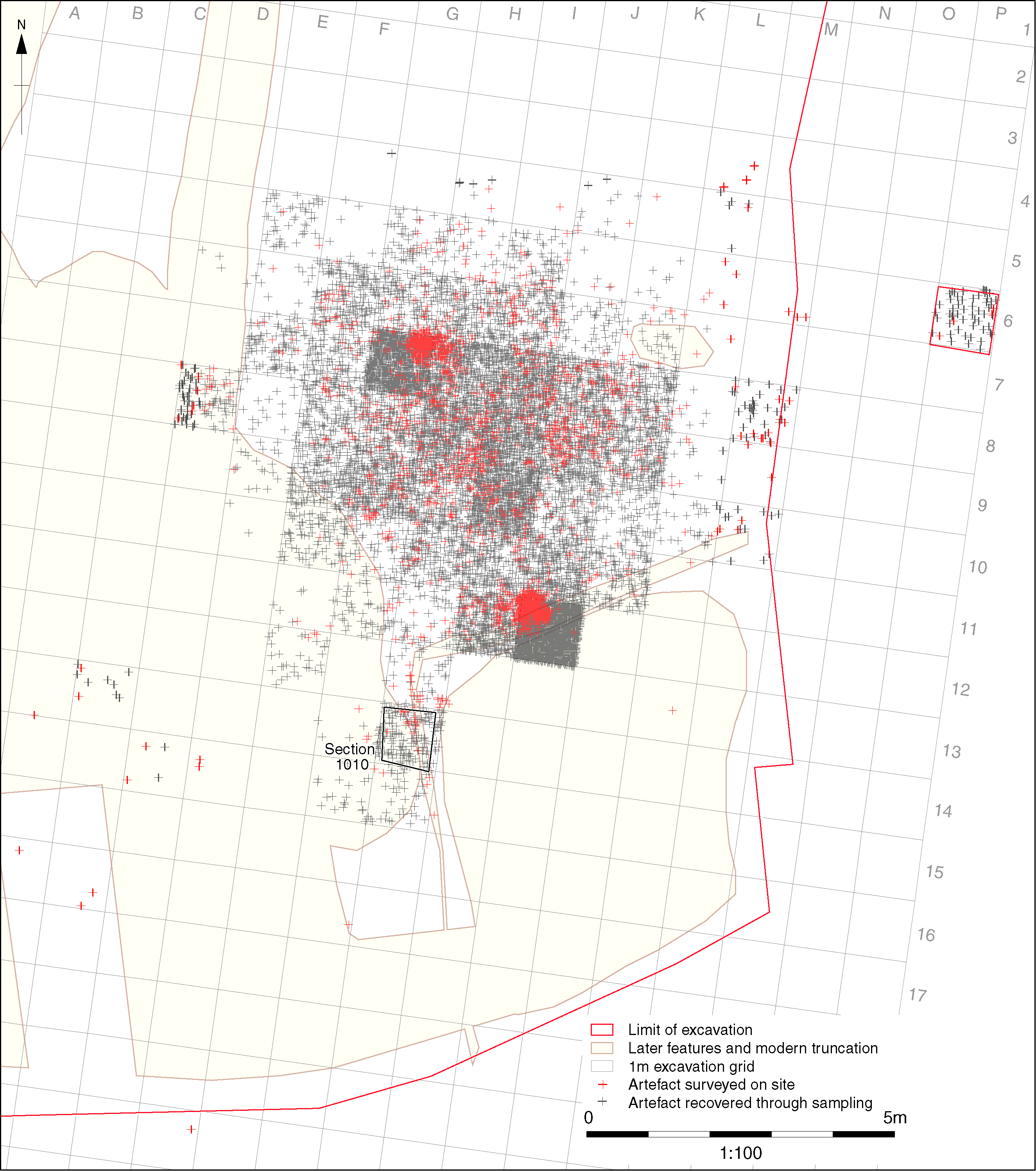

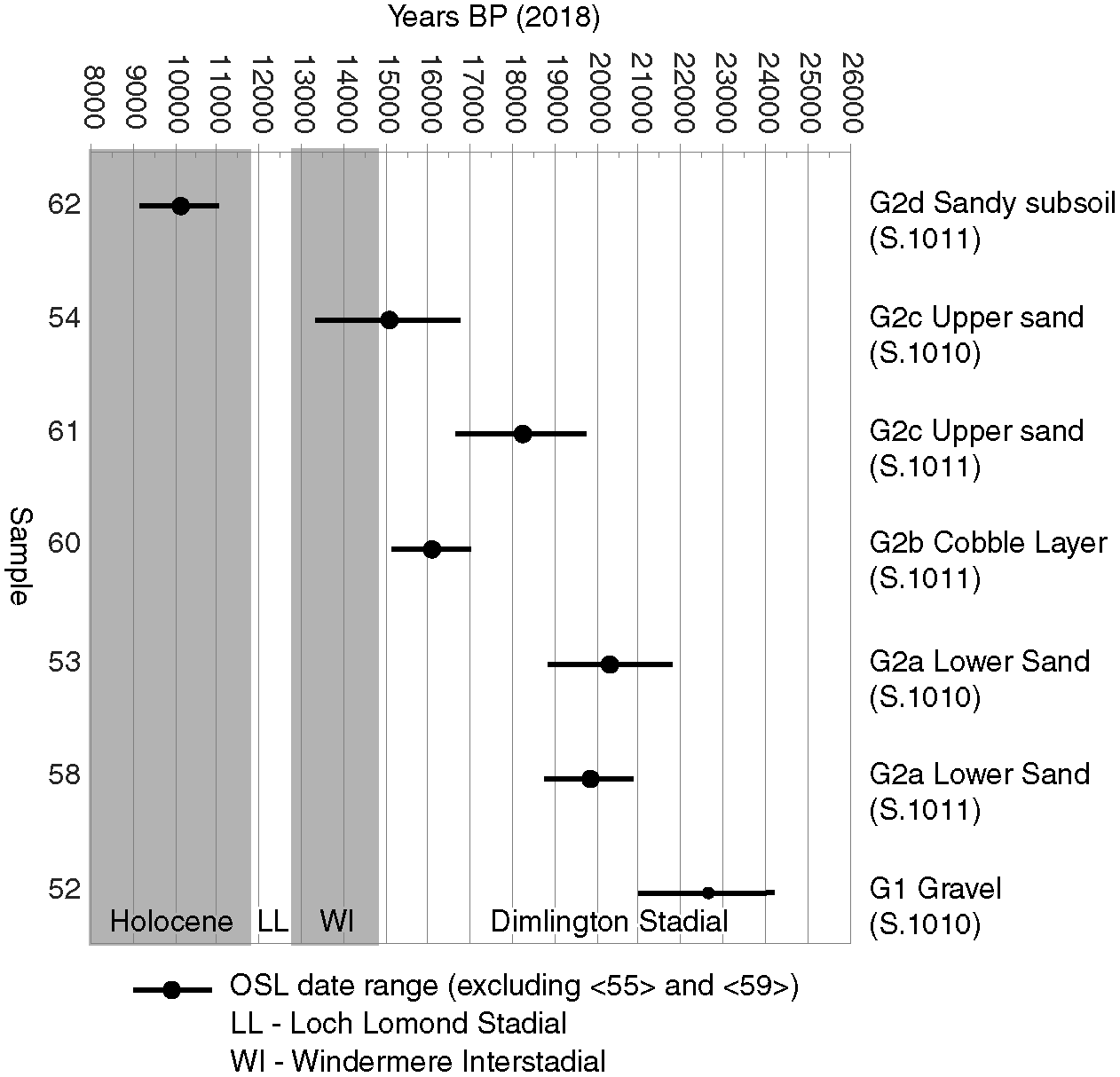
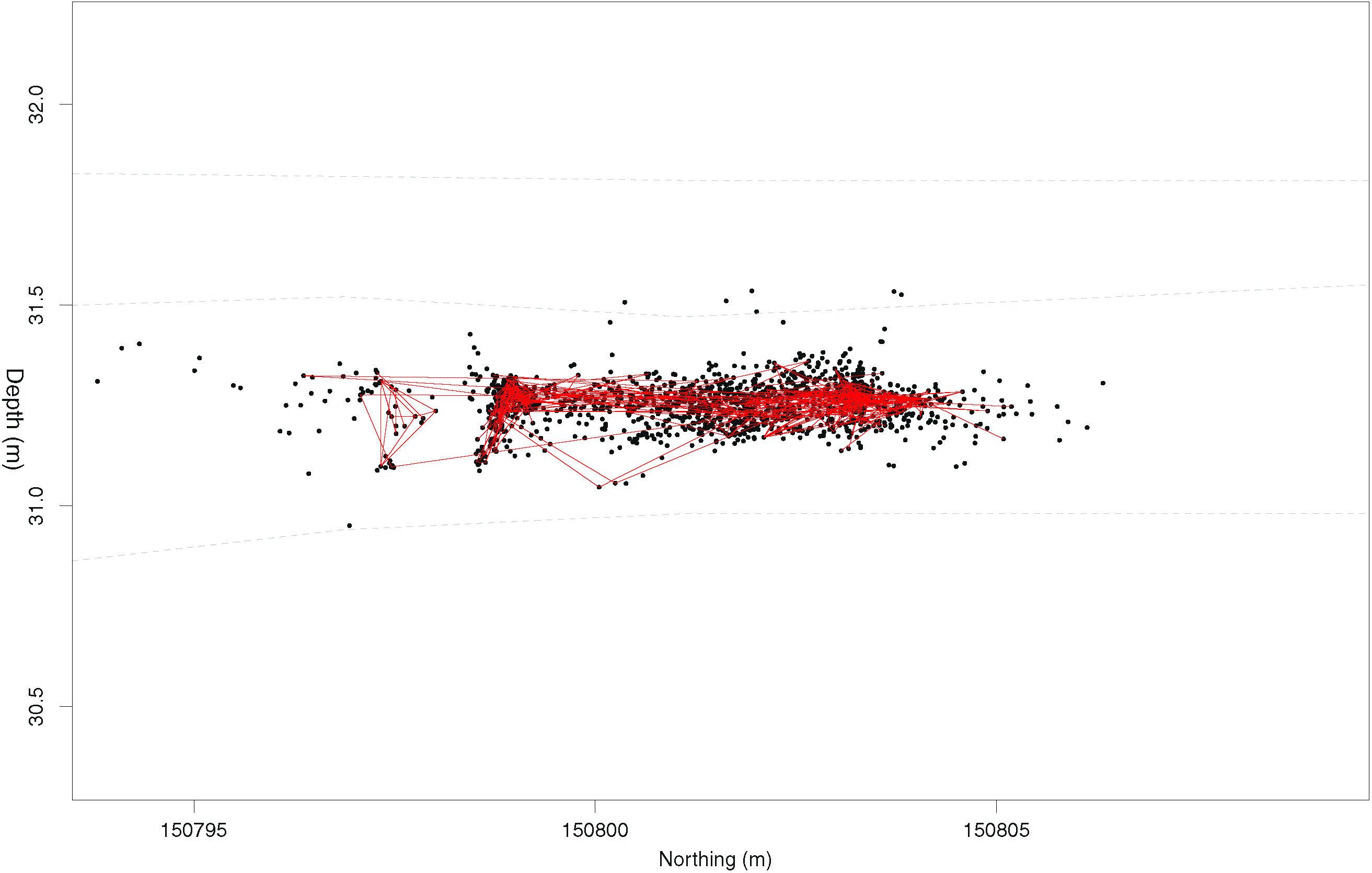

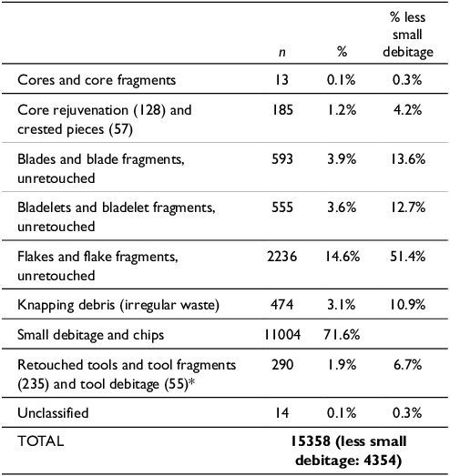


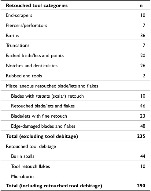
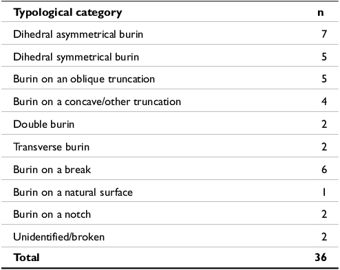
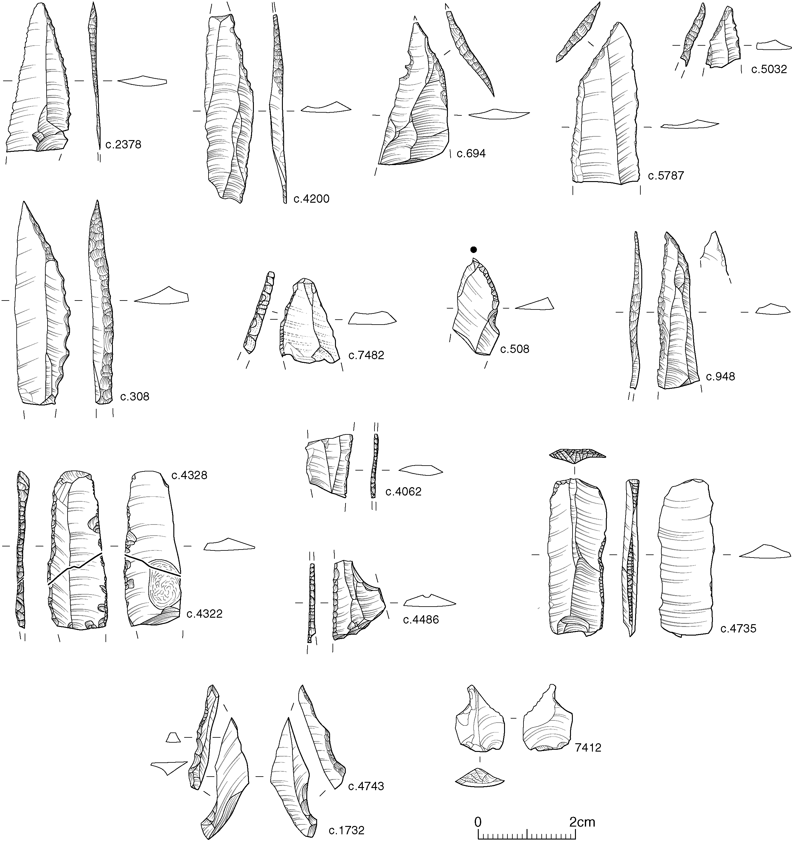
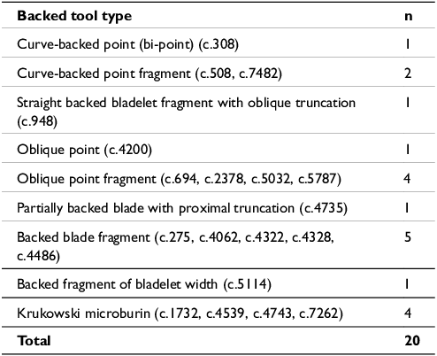


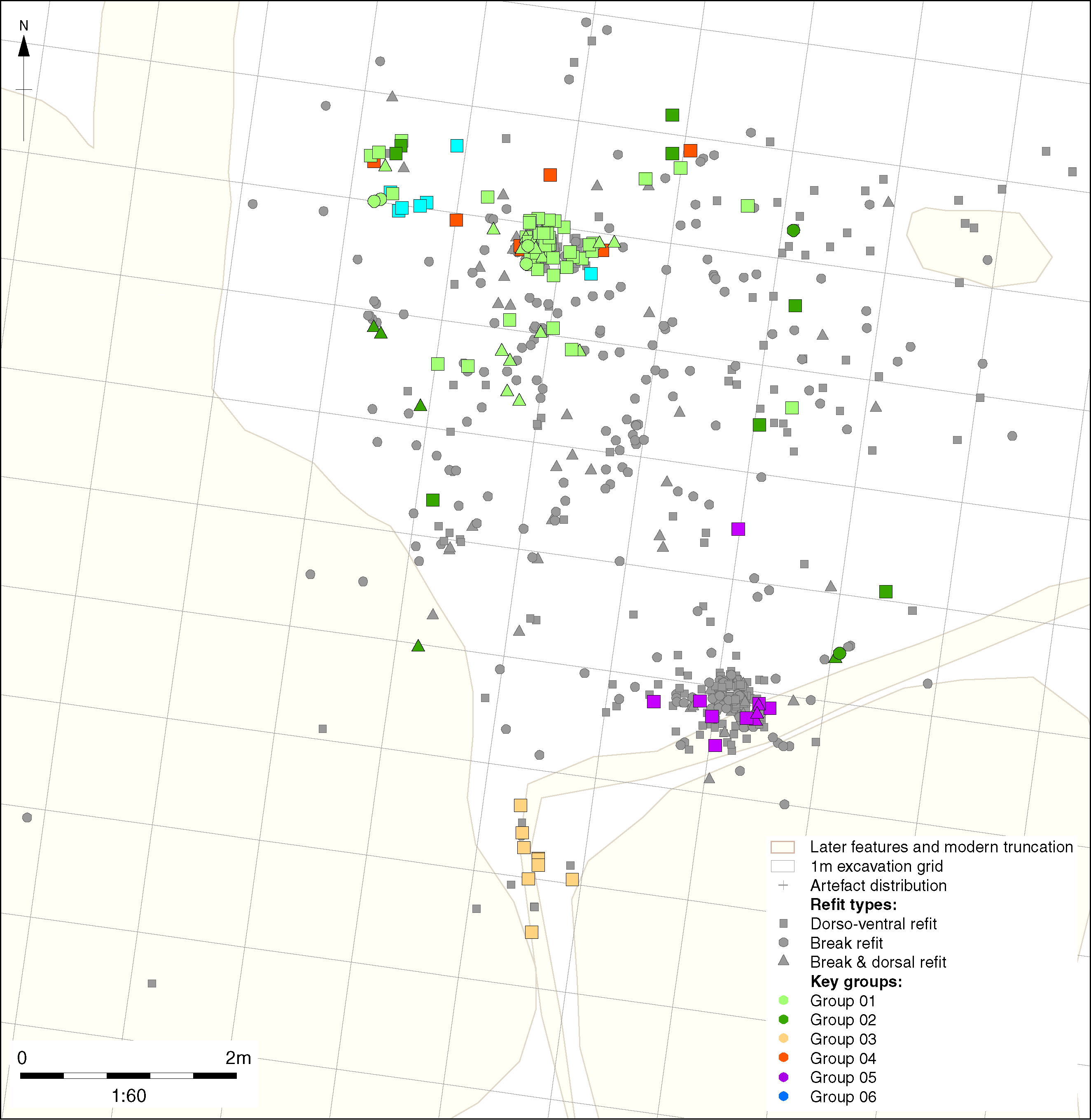

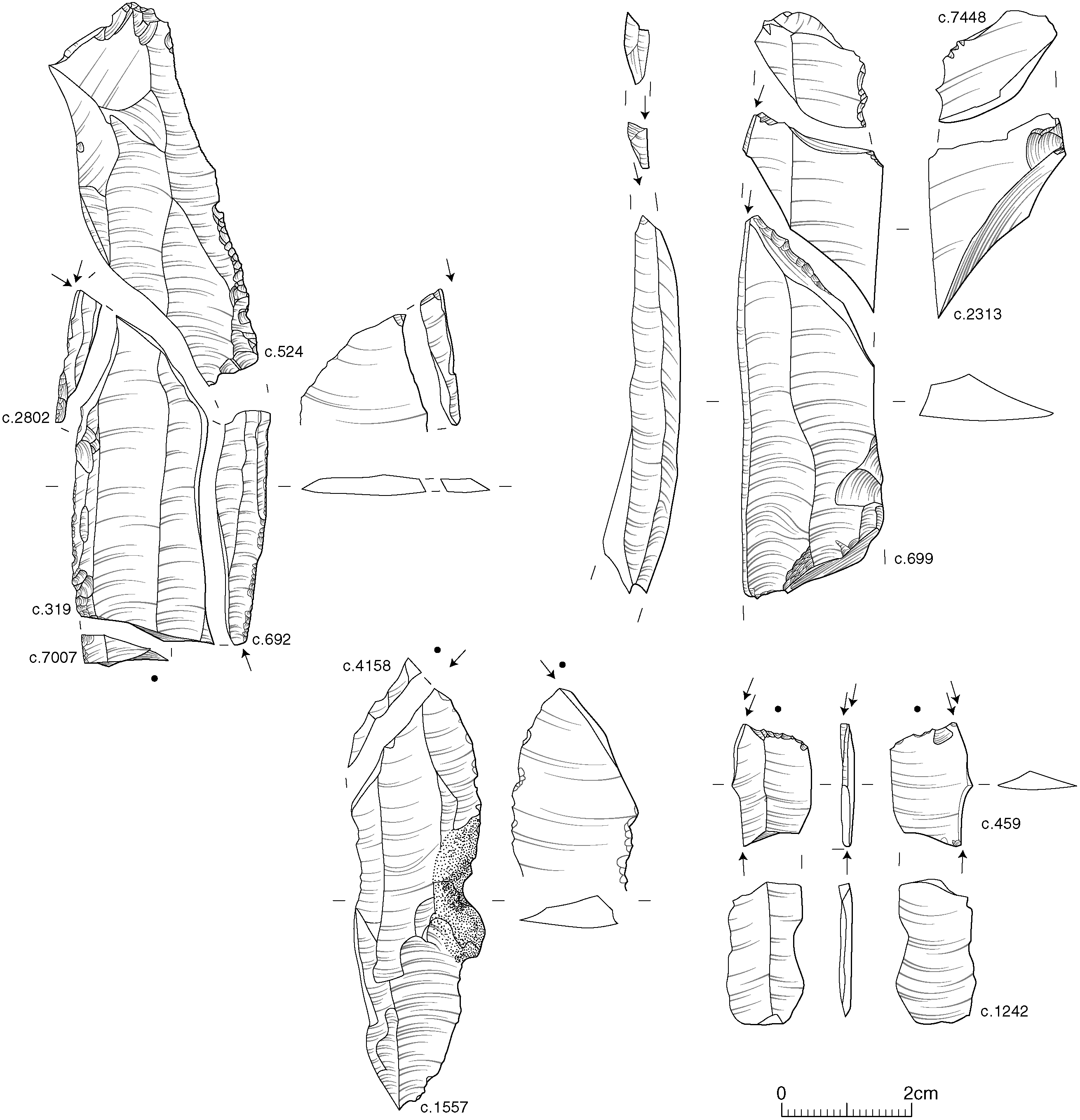

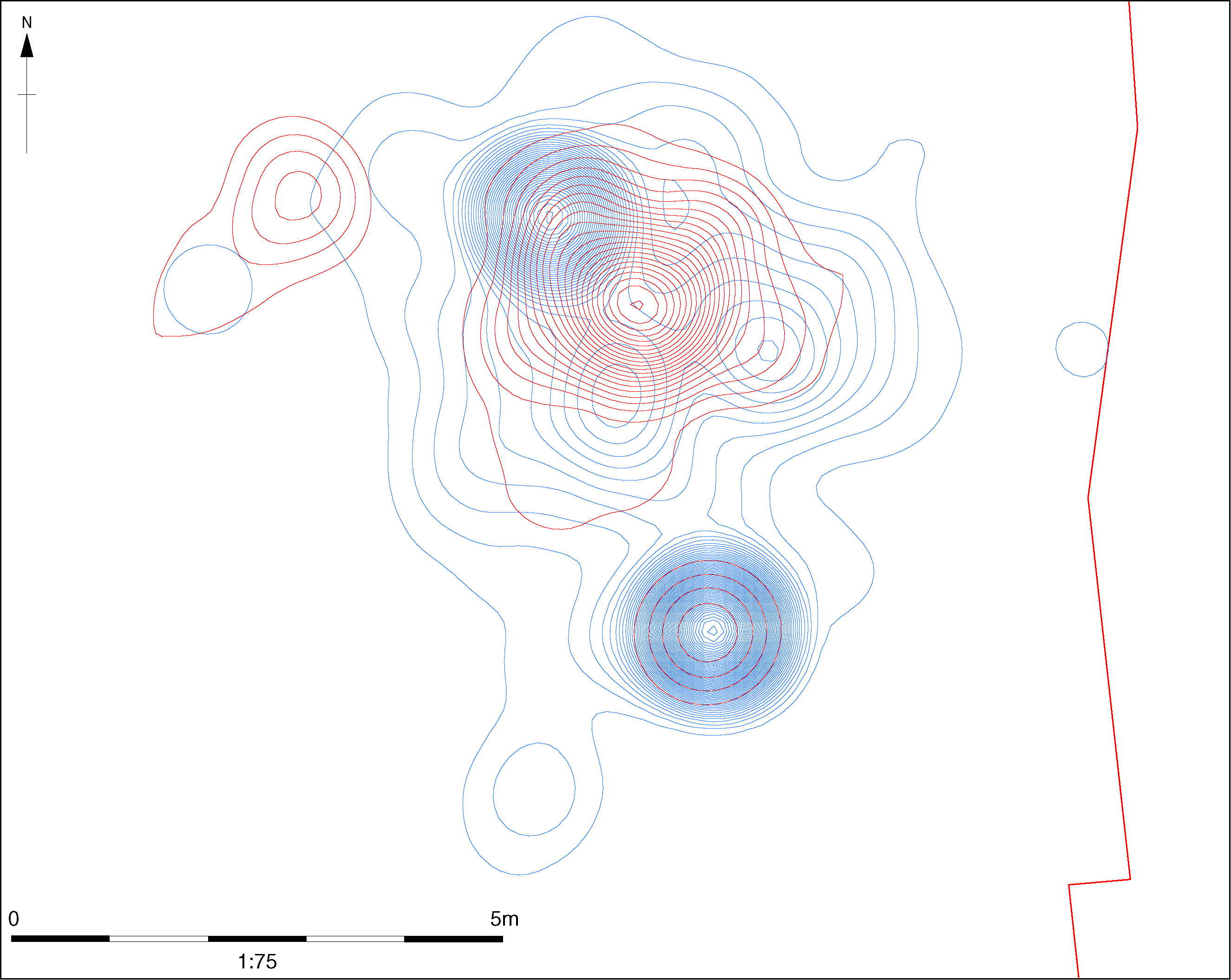

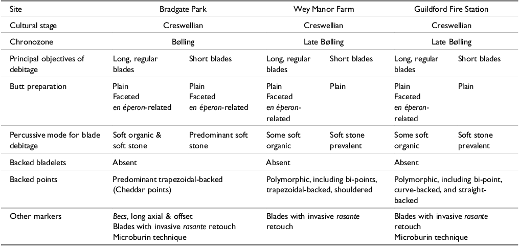


 Open access

