




No CrossRef data available.
Article contents
- Abstract
- HISTORY OF PLAZA PLANS
- MAYA COGNITIVE MODELS: THE DISCOVERY OF PLAZA PLANS
- PLAZA PLAN 2
- DIRECTIONALITY, ORIGINS, AND DISTRIBUTION OF TIKAL PP2
- GRAMMATICAL VARIATIONS OF PLAZA PLAN 2
- ARCHITECTURAL GRAMMARS VERSUS GRADATIONS BYSIZE
- REGIONAL ARCHITECTURAL GRAMMARS
- FORM, NOT SIZE
- HETERARCHY INFERRED: TIKAL PP2
- PLAZA PLANS, DIVERSITY, AND CULTURE CHANGETHROUGHOUT THE MAYA AREA
- CULTURE CHANGE: SURVIVING CITY-STATES INTHE POSTCLASSIC PERIOD
- SUMMARY AND CONCLUSIONS
- RESUMEN
- ACKNOWLEDGMENTS
- References
MAYA HETERARCHY AS INFERRED FROM CLASSIC-PERIOD PLAZA PLANS
Published online by Cambridge University Press: 01 January 2004
Article contents
- Abstract
- HISTORY OF PLAZA PLANS
- MAYA COGNITIVE MODELS: THE DISCOVERY OF PLAZA PLANS
- PLAZA PLAN 2
- DIRECTIONALITY, ORIGINS, AND DISTRIBUTION OF TIKAL PP2
- GRAMMATICAL VARIATIONS OF PLAZA PLAN 2
- ARCHITECTURAL GRAMMARS VERSUS GRADATIONS BYSIZE
- REGIONAL ARCHITECTURAL GRAMMARS
- FORM, NOT SIZE
- HETERARCHY INFERRED: TIKAL PP2
- PLAZA PLANS, DIVERSITY, AND CULTURE CHANGETHROUGHOUT THE MAYA AREA
- CULTURE CHANGE: SURVIVING CITY-STATES INTHE POSTCLASSIC PERIOD
- SUMMARY AND CONCLUSIONS
- RESUMEN
- ACKNOWLEDGMENTS
- References
Abstract
Recognition of architectural patterning among groups of structures at lowland Maya sites dating from the Classic period provides insights into the ways that residences and ritual complexes were organized. Each structured group arrangement, or Plaza Plan (PP), reveals an architectural grammar that provides the database enabling us to predict urban as well as rural settlement patterns. Wide variations in sizes among examples of residential PPs suggests that heterarchy was an important aspect of Classic Maya society. Examination of PP2 at Tikal indicates that a heterarchic pattern of organization existed. Heterarchy may relate to the fragility of the structure of lowland Maya kingship, and this may explain the gradual demise of states during the Terminal Classic and Postclassic periods and their replacement by re-emergent Maya chiefdoms.
Information
- Type
- SPECIAL SECTION: NEW PERSPECTIVES ON ANCIENT LOWLAND MAYA SOCIAL ORGANIZATION
- Information
- Copyright
- © 2004 Cambridge University Press
The vast numbers of ancient Maya sites and the considerable size of many have long challenged our ability to understand and make sense of them. Settlement studies have been concerned with “the total disposition of ancient Maya remains over the landscape” (Ashmore and Willey 1981:3). Regional as well as local and temporal variations in the form and arrangements of Classic-period buildings are now being recognized. Recognition of architectural grammars, or patterning, among household and other specific groups of structures within Tikal provides insights into the ways that these Classic-period Maya organized their residences and ritual complexes at this major site (Becker 1982, 1999). The recognition of group patterns, or Plaza Plans, at Tikal depends on decoding architectural grammars (Becker 2003a). These can be used to understand urban settlement within a site as well as rural settlement patterns throughout the Maya realm.
HISTORY OF PLAZA PLANS
The meaning of settlement pattern, whether the configuration of individual groups, the distribution of groups throughout a site (cf. Fletcher and Gann 1995), or the distribution of sites across the landscape (Morley 1937), represents the final goal of these studies. Efforts to understand the Classic Maya through architecture continue to place emphasis on “elite” structures rather than through an overview of Maya society (Houston 1998; Inomata and Houston 2001; Webster 1998). Recognition that most groups of structures at lowland Maya sites represented extended family “households” (Haviland 1988; Wilk 1988), similar in their physical as well as cognitive composition to those known from recent ethnographic studies continues to be confirmed by extensive mapping projects. The Plaza Plan approach to understanding site structure views Maya society from a “functionalist” perspective (Becker 2001; Johnston and Gonlin 1998:142).
More important for the recognition of these Maya houses is the role that they played in understanding how Maya society could function effectively within a tropical rain forest. Note that in the Maya area, Frederick Wiseman's concept of the “artificial rain forest” (Adams and Hammond 1982:502) would be best suited to a series of residential clusters between which trees can grow and over which branches could spread. This system of controlling the rain forest, with each family creating a “managed rainforest” through complex intercropping, also has been called a “managed mosaic” (Fedick 1996). Evidence suggests that early farmers entered the lowlands as egalitarian slash-and-burn horticulturalists and that they developed a socially differentiated society by the Late Preclassic (Hammond 1978, 1992; Voorhies 1996). Increasing population densities then forced farming methods to intensify, with a shift to heavy intercropping, in a standard process of agricultural intensification. The thesis that the Classic Maya relied exclusively on swidden (milpa) agriculture has been uniformly rejected (Fedick 1996:3–13).
MAYA COGNITIVE MODELS: THE DISCOVERY OF PLAZA PLANS
Most of the approximately 2,500 individual and separate structures mapped at Tikal can be placed into 690 relatively discrete architectural groups (Becker 1982; Carr and Hazard 1961). The interpretation of social relationships among the residents of the extended families occupying household groups (Haviland 1988) has reemerged as an important subject (Manzanilla and Barba 1990; McAnany 1993). Julia Hendon's (1991) contextual analysis, examining the function of individual structures within complex architectural groupings, emphasizes the relationships among individual buildings as part of a group rather than examining them as if they were isolated entities (see also Haviland 1992; Hirth 1994).
The study of clusters of structures within Maya sites often, but not always, reveals a variety of identifiable group plans that can be recognized though detailed mapping alone. Each type of identifiable group can be characterized by one or more specific features that can be seen on a site map, without or prior to excavation. At Tikal, the diagnostic feature or features characterizing a specific type of group have been used to define each as a distinct Plaza Plan (Becker 1971, 1999). In effect, each of these group plans conforms to a set of cultural rules involving building form and location that result from an emic typology, or what I call an architectural grammar. Each specific Plaza Plan (PP) can be delineated through two levels of proof. First, regularities of architectural patterning, or the grammatical elements of building shapes and group arrangements, can be seen through map inspection alone. The second level of identification involves excavation to verify the architectural details as well as features specific to each type of PP. Thus, PP2 at Tikal involves a relatively small, relatively square, and relatively tall building platform centered on the eastern side of the group's plaza (Becker 1999). The identification of architectural regularities that began as a heuristic model during small structure studies at Tikal in 1962 was confirmed after a few weeks of further excavations (Becker 1971). The initial recognition that groups of buildings at a site could be categorized by highly predictive, conservatively estimated at greater than 90%, architectural grammars provided considerable potential for developing research strategies based on map studies alone (as with Carr and Hazard 1961). This information facilitates the planning of excavations and provides a means for ordering data within and between Maya sites (Becker 1979b, 1982; Fletcher et al. 1987).
The archaeological testing of identified examples of each architectural grammar, or PP, permits us to make accurate predictions of the presence of unseen mortuary and artifact assemblages as well as other aspects of material culture or even architectural features not evident from the surface. Specific artifacts associated with a specific group also may reveal aspects of the function of the group or occupation of its residents (Becker 1973) in a mode parallel to artifact studies made by anthropologists in what some now call “cultural biography” (Hendrickson 1995).
Archaeological intervention, the second level of confirming as specific PP, can focus on the recovery of “predicted” elements demonstrated to have regularities that can be statistically validated (cf. Doran and Hodson 1975). Test excavations of PP2 groups provided the architectural details characteristic of each east-located shrine. Precise measurements, when subjected to statistical analysis, demonstrate that structures on the east of PP2 groups are significantly distinct in plan from all other structures in the same group (Becker 1999). This nomothetic approach to the evaluation of architectural groups, whether of domestic clusters, ritual complexes, or something in between, serves as an extremely valuable tool for planning excavation strategies. I agree, however, with Norman Hammond (personal communication 2003) that a polythetic model more closely represents these grammars (see later). For the formulation of basic questions regarding a site and its component parts, this very simple system can be highly efficient.
The discovery that the form of an architectural group at Tikal can be more significant than might be expected from its physical size (Becker 1971, 1999:197–205) is one of the most important findings of the settlement research program at Tikal (Becker 2003a). The analysis of group form helps to clarify the meaning of data gathered at this enormous site during four decades of excavations. Excavation data also reveal that similarities in form among household groups within Tikal, as well as between sites, are particularly useful in formulating hypotheses regarding culture change in time and space.
Each PP recognized at Tikal conforms to an architectural grammar (an emic or cognitive model, or mental map) employed by the Maya builders and users of these building clusters. PPs reflect those aspects of the architectural grammars that relate to the structures within a group, rather than those that reveal individual room function (Harrison 2003; Hendon 1991). At many sites the fundamental rules of each of these grammars can be identified from surface observation alone (Becker 1999). As noted, the evaluation of PP from surface observation alone provides only the first set of data needed to decode the function of each specific grouping of structures.
A second set of data, derived from excavations, is essential to confirm observations made from map or surface observation. Excavations also may reveal elements of the architectural grammar that are not evident from the surface, such as unique burial or cache placements or specific goods associated with these “earth offerings” (Becker 1992, 1993). For example, a specific and always associated mortuary complex is associated with Tikal PP2. Of note is the need for excavation data to verify whether some structures were vaulted or had stone walls but thatched roofs. However, in no PP is presence or absence of vaulting a factor in the grammar, a note to which we will return later.
Statistical analysis using the precise measurements recovered through the excavation of a building provides a third aspect of the analysis. These three levels of observation provide high predictability that leads us to consider a fourth level—why changes in these group arrangements occur through time (Martin 1971:3–4). For example, we would like to understand why some PP2 groups were transformed into PP3 types while some PP3s were converted into PP2 (Haviland 2004). The appearance, proliferation, or disappearance of various PPs through time serves to indicate culture change within the complex societies that generated these ancient Maya cities. A concise summary of the ten PPs delineated at Tikal is now available (Becker 2003a).
PLAZA PLAN 2
Extensive work at Tikal has permitted us to refine our ability to distinguish between two very similar architectural patterns, now identified as PP2 and PP3, and to infer residential functions for both (cf. Laporte and Iglesias 1999).
Household groups at Tikal that include a relatively square and tall structure on the east and relatively low, rectangular structures in other positions describe a distinct arrangement now designated as PP2 (Becker 1999). Excavations revealed other traits that distinguish the structures on the east from those in other positions. These traits and architectural details of the east building suggest a function as a ritual shrine or temple (oratorio) for the resident family members. Non-square, non-east buildings in the group are assumed to have served other domestic purposes, such as “bedroom,” dormitory, men's house, kitchen, or storage. Inferences regarding specific structure functions (cf. Becker 2001) remain difficult to confirm through excavation.
Morley's (1935:135–146) map of the Temple Plaza Group at Quirigua thus provided sufficient evidence to enable correct prediction of structure function and burial location within Structure 6, a very small structure first cleared some 100 years ago (Becker 1972). Several years after this prediction appeared in print, an axial trench through Quirigua Structure 6 confirmed my hypothesis that the architectural grammars defined at Tikal could be successfully applied at other sites. The same theory regarding PP2 also was used to predict that Structure 16 at Copan, on the eastern side of its plaza (Becker 1980:20–21), held the tombs of the “kings” of Copan. Excavations have long since demonstrated the accuracy of this prediction at Copan.
Other excavators have successfully employed these data in their research strategy. In 1999, these PP2 observations were used by Arlen Chase and Diane Chase as a guide to a tunneling program into the base of Caracol Structure A3 in search of royal tombs. More important is their estimate that as many as 70% of the architectural groups at Caracol conform to PP2, a sharp contrast to the low percentage at Tikal. Mayanists have long recognized the presence of PP2 groups at other sites (e.g., Leventhal 1983), but pursuit of research based on these findings remains limited (Becker 2004b).
Details of the relationships among buildings in several groups at Tikal as well as extensive PP2 data from other sites now are being gathered (Becker 2004a). Jon Hageman and Jon Lohse (2003) describe what they call “first-tier groups” at Dos Hombres in northwestern Belize, each of which is central to a series of households (architectural groups). Only these “first-tier” groups at Dos Hombres conform to PP2. They commonly dominate a recognizable clustering of residences, leading Hageman and Lohse to suggest that they reflect the existence of “corporate groups.” They also point out that each of these PP2 groups “is far from being a royal pyramid or located in the monumental center of Dos Hombres” (2003:115) At Tikal, the Carr and Hazard (1961) map demonstrates that PP2 residential groups come in every possible size (Figure 1), and only a few examples of the largest of the diagnostic eastern buildings at Tikal appear to have been vaulted (Figure 1a–d, possibly 1e; Becker 1999). Smaller examples supported only thatched structures. Thus, neither size nor vaulting is a trait of importance in defining PP2 or any of the other PPs identified.

A sample of six unexcavated PP2 groups at Tikal of varying size, all presented at the same scale (derived from Carr and Hazard 1961). Excavated examples of PP2 are the subject of Tikal Report 21 (Becker 1999), in which examples intermediate in size between E and F are documented. (A) Group 6C-IV (Structures 6C-41/43). Typical small example; (B) Group 6E-XIX (Structures 6E-81/84); (C) Group 6E-XXXII (Structures 6E-139/142). A mid-size group situated adjacent and to the southeast of Group 6E-XIX. At Tikal, PP2 groups are rarely located together, except in two parts of the city (Becker 2003b); (D) Group 7B-X (Structures 7B-25/28); (E) Group 2C-XVIII (Structures 2C-73/78); (F) Group 6B-II (structures 2B-16/40). The Barringer Group, a “site”-size residential complex within central Tikal.
Excavation data from the diagnostic structure on the east of Tikal PP2 groups provide additional grammatical elements essential to delineation of a specific cultural pattern. A specific mortuary pattern, plus ceremonial activity in the form of on-floor burnings, help to indicate the function of these buildings, now identified as shrines. The Tikal PP2 mortuary complex includes an extremely important grammatical rule involving an “intrusive interment and covering” dyad. No PP2 can exist without first intruding a burial chamber into the bedrock and then covering it with a ritual building that is tall and square in plan. Each subsequent rebuilding was preceded by the intrusion of another high status burial (Becker 1971, 1999).
In general, the burial chamber is placed in a roughly centered axial position, but this location relative to the completed cover building is not a rigid rule. The same “interment-covering” rule applies, with one specific modification needed if a building already exists at the locus of the planned ritual structure on the east. In this case, the intrusion for the initial or first PP2 interment in that location must penetrate the existing building, whether it is a ritual or secular structure, and then extend down into the bedrock. The ritual PP2 building then covering this grave may also cover much if not all of the original construction at that locus.1
Ritual and Cosmology may be inferred from the “planting” of the “kings,” as well as of the more humble peoples, at Tikal who were resident in PP2 groups. PP2 at Tikal involves the opening of the earth (bedrock) for the grave and the covering of it with a tall structure that is equivalent to a mountain (the enclosure of most caves). The cultural rule is that all subsequent burials need only penetrate the tall structure and not extend down into the original bedrock, since the structure now is the cognitive equivalent of a mountain. James Brady (1997:614) suggests that where a real hill, or possibly a rise in the terrain, serves as the base of a pyramid, or when a pyramid is built over an actual cave, the “surface architecture becomes an extension of and interwoven into the sacred landscape.” This may be why, in the creation of PP2, the transformation of a “structure” built at a locus where a “mountain” (shrine) is to be built requires that the burial pit (“cave”) penetrate through the existing structure and into the bedrock. In fact, a notable feature of Early Classic burial chambers at Tikal is the “step-down” entry that creates a cavelike mouth from which one “enters” the burial chamber proper. Brady's description perfectly describes the architectural rules associated with the construction of examples of PP2s at Tikal. At Tikal, the chambers in which these PP2 burials were placed evolved from the “step-down” type of the Early Classic to the vertical-shaft variety common in the Late Classic. Changes in details of the interment process had no effect on the basic grammar associated with PP2.
Of the 690 architectural groups at Tikal, a total of 96 (14%) were predicted to conform to PP2 solely on the basis of their mapped configurations (Becker 1982). Dennis Puleston's (1983) study of the South Brecha at Tikal, extending 12 km out from the site center, identified a total of 128 architectural groups, of which 19 (15%) conform to PP2. The remarkable similarity in these percentages and their apparently random appearance throughout the test area suggests that PP2 has a consistent distribution throughout the greater Tikal region. This percentage is similar to that found at Tayasal (Chase 1983; Chase and Chase 1994:53).
Note should be made that PP3, the most common residential group plan at Tikal, lacks any shrine. PP3 is represented by about 400 of the 690 architectural groups at Tikal, or about 60% (Becker 1982; Carr and Hazard 1961). Data derived from excavations in non-eastern structures within PP2 groups at Tikal, as well as in various buildings from groups conforming to PPs 3, 4, and 5 (Becker 2003a), all seem to reflect the use of these groups as household units (residences for an extended family). Differences in various details of arrangement among these groups may reflect social class differences, but an alternative possibility may be suggested: heterarchy (see later).
While rarely found adjacent to one another, nine of the PP2 groups located in central Tikal are clustered on a peninsula jutting into the Bajo Sante Fe (Carr and Hazard 1961). In 1962, six of these groups were excavated, and the other three were resurveyed. These nine groups provided the type plan for PP2. Subsequently, six of the other 87 groups at Tikal that had been predicted to conform to PP2 (Becker 1982) were randomly selected for testing to validate the hypothesis that PP2 configurations could be recognized by surface survey and evaluation of architectural pattern. The 1963 Tikal excavations focused on the east-lying structure in PP2 and PP3 groups and demonstrated the predictive power of this architectural grammar.
This third level of PP “identification” may be considered as the ultimate target of this line of research—the goal of providing an analysis of the information derived through excavation to identify function. For PP2 and PP3, extensive work at Tikal has permitted us to refine our ability to distinguish between two very similar architectural patterns and to infer residential functions for both PPs (Laporte and Iglesias 1999).
DIRECTIONALITY, ORIGINS, AND DISTRIBUTION OF TIKAL PP2
Three factors relating to any PP merit extended treatment and should be basic research goals in PP studies. These aspects of PP research are important to the study of cultural dynamics and change among the lowland Maya (Becker 2004b). Ashmore (1991:200, 1998) addresses questions of directionality in Classic Maya site planning, providing valuable insights and interesting interpretations of the cultural processes underlying the organization of space among the ancient Maya. The direction “east” is uniformly important to the Maya. The location of the diagnostic structure or shrine on the east of PP2 groups calls to mind Coggins's (1980:729) suggestion that among the Maya “east” is invariably the position of honor, and that Maya maps dating from the Colonial era place east at the top.
The origins of PP2 at Tikal can be dated to the first part of the Early Classic period. I suggest an evolution from the earlier E-group (PP10) pattern in which the structure centered on the east also was significant. The transition from PP10 to PP2 may be part of, or associated with, the processes of social and cultural transformation that lead into the Classic period throughout the Maya area.
Some hints about the distribution of PP2 within the Maya realm derive from the early descriptions of tombs found at Maya sites where the structure orientation was not known or not published. Many of these tombs now can be inferred to have come from temples that were on the east of PP2 groups (Galindo 1920:596; Gordon 1896:4, 11–12). References to groups at several sites that conform to PP2 also can be found in works by Thomas Gann (1927:51–52), who identified “conical” mounds that had axial burials, and in the writings of J. Eric Thompson (1931:235, 336) and Linton Satterthwaite (1937:174). The work of Willam R. Bullard touched on the significance of architectural groups, and by 1960 he had noted large residential groups called “sitios,” found in northeastern Peten, often included a “small pyramidal structure which was probably a shrine” (Bullard 1960:359). A. Ledyard Smith (1962:220–221, Figure 11) describes similar groups at Mayapan, referring to each structure on the east as an “oratory” in recognition of the ritual functions that he inferred. Modern site maps often reveal numerous examples of this plan (e.g., E12 at Coba; Manzanilla and Barba 1990:43, 45, Figures 2, 3; see also Folan 1977), or their apparent complete absence!2
PP2 also appears to be found at sites far beyond the southern Maya Lowlands, possibly represented as part of the architectural pattern associated with the Mississippian culture that flourished into the heartland of North America in the eighth and ninth centuries a.d.
PP2 groups are common throughout the Maya Lowlands, but with considerable variation in the percentages of them found at any one site. Chase and Chase estimate that 60% or more of all groups at the site of Caracol are “eastern shrine groups,” or what I identify as PP2 (Chase and Chase 1994:53–54; also Chase and Chase 1996:215). Variants of PP2 at other sites may include different positioning and orientation of the shrine, but such variations in “form” requires another line of research that is site specific.
GRAMMATICAL VARIATIONS OF PLAZA PLAN 2
Notes regarding the distribution in time and space of PP2 groups moves our level of understanding of this pattern toward the examination of additional considerations. The ideal “Temple-on-the-East” residential and civic pattern described at Tikal as PP2 provides a focus for only one aspect of settlement studies. Further observations at Tikal have refined our understanding of grammatical variations among the several previously defined PPs (Becker 1999).
Early in PP research at Tikal an interesting variation of the PP2 pattern was recognized. The variant form was found to have two temples along the eastern side of the group, either as a matched pair constructed at the same time or as a pair of unequal size created by the off-axis construction of a second, smaller temple adjacent to the first (Becker 1979b:11–12, 1982).
I propose that a letter be appended to the basic PP2 designation to identify variations in patterns as they are recognized, which in this case would be PP2A. While we remain ignorant of the emic meaning of these variations, it behooves us to document and describe the known examples. All Tikal examples of PP2A date from the Late Classic. Examples from Tikal, such as Group 7F-1, begin as normal PP2 groups and at some time during the Late Classic period shift into the PP2A form through the construction of a second shrine, generally to the south of the first. PP2A groups seem to become increasingly common during the Terminal Classic and Post-Classic periods.
As other examples of PP2 are recognized at lowland sites, such as Dos Pilas (Palka 1997:Figure 1) and Caracol (Structure B20-1st-B; Chase and Chase 1998:307), other letters may be appended to PP2 to reflect variations on the basic theme. The introduction of PP2 or some variation on this plan to any site may reflect the founding of a new lineage or other co-residential factors in the household.
Toward the end of the Classic period, we see the simultaneous construction of a pair of temples of the same size on the east. This may be a Terminal Classic phenomenon representing a cognitive change as yet unknown, possibly related to the much later double- and equal-size temples on the east, built on a single substructure, known from later Aztec architecture (Fox 1981, 1987:202–203, 233–235).
Also noted at Tikal is the regular pattern of locating a platform to the north of the “shrine” on the east. At other sites, tall, square shrines may be situated in a consistent location, such as on the west (PP2C) or on the south (PP2D). The numbers of sites from which dual temples on the east, or some other variations, are known appears to be quite large. Many of the 71 groups mapped at Ixtonton, in eastern Peten, conform to PP2, and a number of these can be determined to be PP2A.
ARCHITECTURAL GRAMMARS VERSUS GRADATIONS BY SIZE
Among archaeologists interested in settlement studies a focus on structure size has detracted from research relating to architectural grammars. The importance of recognizing the presence of very small structures, often unseen by even the most diligent surveyors, is critical to understanding the total settlement pattern at any site. Evidence for these often “invisible house mounds” was sought at Tikal in a special project directed by Bennett Bronson, and later at Seibal (Tourtellot 1988:345–350) and at Nohmul (Pyburn 1989). Research that targets very small structures continues to produce exciting results in the Maya area (King and Potter 1994:65; Webster and Gonlin 1981). Recent scholarly interest also is concerned with decoding the specific functions of the groups that include such features. Considerable success has been achieved recently in identifying very small structures in the northern lowlands where less dense ground cover makes surface visibility good. All of these studies of small structures provide vital clues to the organization and social structure of Maya sites. These studies are particularly important because some of these very small groups of structures incorporate PPs that are also found in very large residential as well as ritual groups. Thus, very small and very large “households” that have the same architectural grammar must have some elements of culture in common. These shared elements point out an interesting problem in Maya studies. While the attention directed toward large architectural groups may have merit, the belief that relative group size is the only variable that matters in the study of Maya settlement patterns has hindered progress in decoding the structure of Maya society.
REGIONAL ARCHITECTURAL GRAMMARS
Two decades ago, Don Rice and Dennis Puleston (1981:138–139) noted that the study of “structure aggregates” as suggested by Haviland (1963:466) would be the preferred way to examine Maya sites. Renewed interest in site planning (Houk 1996; Scarborough, Connolly, and Ross 1994; Scarborough, Becher, Baker, Harris, and Valdez 1995) has generated important new perspectives on Classic Maya sites, but mostly geared to size ranking. These approaches to settlement studies in Maya archaeology tend to focus on group size rather than form (Willey 1982). Recognition of architectural patterning enables us to apply these grammatical findings at other sites.
The Three Bears: Implications for Heterarchy
“Goldilocks and the Three Bears,” a story for children, provides an important cautionary tale for interpreting studies that seek meaning in the relative size of architectural groups (Becker 2003a). The “Three Bears” approach to Maya architecture involves the use of “group size,” variously calculated, to evaluate the social class of the occupants of these architectural complexes. Size-related studies produce descriptions of architectural groups that implicitly suggest hierarchical ranking as fundamental to Maya social order. Thus, the story of the three bears does not answer a basic question: What is the gender of the baby bear? The gender is irrelevant in a story in which size is emphasized and belongs in a separate category of “gender studies” in archaeological interpretation. Size-based analyses of architectural groups seems as irrelevant to studies of household and other groups as the gender of the baby bear is to that fairy tale. More relevant to understanding the Maya may be information regarding the “ethnicity” of the bear family, which clearly is distinct from that of Goldilocks and her unseen family.
Attempts to infer site organization and meaning from the relative size of specific residential groups (Webster 1998:17) risk creating circular arguments. Robert Sharer's (2003) critique of the Copan Valley typology in which group size, as well as post-excavation inferences from construction materials and artifacts, are used to infer “class” is a circular argument. Settlement research at Copan, for example, emphasized group size as a variable, with up to four “types” of groups discussed (Freter 1994; Gonlin 1994:177; Webster and Freter 1990; Willey and Leventhal 1979). The evaluation of any large group as the residence of the “elite” needs better definitions and requires confirmation through sets of architectural and artifactual evidence that remain to be specified (Webster 1998:24).
Although commonly employed, the size–rank, or “three bears,” approach has not produced any useful predictive models. The size of individual structures, such as the “size” of residential groups (total “surface area” of the buildings), may be used to estimate populations of lowland Maya sites (Eighmy 1981), but even this correlation may be based on faulty assumptions. Unless one is simply seeking elite goods or texts through the excavation of groups of large size, ranking groups by size still lacks methodological order and explanatory value. For example, finds of important sculpture at the impressively large “Skyband Group” at Copan led the authors to apply the term “elite” to its residents (Webster et al. 1998). While these residents appear to have been “rich,” they also may have been a family of stone carvers, or even quarry owners or affluent masons (Becker 1973).
FORM, NOT SIZE
Many enormous residential groups within Tikal are located far from the elite residences on the central acropolis. We may be seeing the earliest “suburbs” in the New World. The traditional “center city” people at Tikal lived near the Great Plaza, and their “commuting cousins” lived in impressive residences some distance from the center, such as Group 7F-I or Group 6B-II (the “Barringer Group”; Figure 1f), both of which conform to PP2. Thus, the range of variations in the absolute size of each of the groups conforming to PP2 is striking. At Tikal, PP2 groups range in size from extremely small to extraordinarily large, with the largest within greater Tikal such as the Barringer Group being the size of many small Maya sites (Pyburn 1989). This indicates that something else in involved in the configuration of these groups—something embedded within the culture that transcends status or wealth.
We have demonstrated that the form of PP2, as well as of other types of groups, is remarkably consistent (predictable) throughout Tikal, regardless of group size (Becker 1999). This suggests that some of the residential PPs had been occupied by more wealthy families but without revealing the ways in which the people in these larger groups are otherwise different. Quite probably, occupational differences existed among residents of groups sharing the same PP (Becker 1973). Different PPs might reflect the residences of different moieties or even the presence of different ethnic groups within a site.
Wealth, as reflected by group size, is not correlated with any particular PP. Gair Tourtellot (1988:362) specifically noted a lack of correlation between dwelling size and wealth, or status. In Maya archaeology, as with studies of modern American society, the distinction between “elite” and rich is rarely addressed and remains unclear to most scholars (Moholy-Nagy 2003). Since any specific PP (e.g., PP2) at Tikal was built in all sizes (Becker 1982, 1986, 1999), use of these architectural grammars may provide an important research strategy for understanding what the presence of these groups means at Tikal and at other Maya sites. Inasmuch as the form of a specific PP is more predictive than the size of its architectural cluster, this suggests that a non-ranked view (heterarchy) of these groups might be useful.
HETERARCHY INFERRED: TIKAL PP2
While the most elaborate house groups might represent high status or elite residences, Tourtellot's observation, noted earlier, should be kept in mind. Ranking “houses” or “courtyard groups” by size in areas where a series of discrete architectural groups can be found is an extension of the regional rank–size analysis of Maya sites pioneered by Richard Adams and Richard C. Jones (1981; Adams 1982). More recently, Daniel Potter and Eleanor King (1995:21) examined regional rank–size analyses as applied to Maya sites. Rank–size analyses yield useful predictions of site size and settlement patterning through space, but attempts to apply such theories to groups of structures within individual sites have been notorious failures. Related to rank–size analysis within a site is the erroneous belief that “concentric zonation” can be seen at Tikal (Arnold and Ford 1980). The idea that internal zones exist at Tikal reflects a series of errors already reviewed in the literature (Folan et al. 1982; Haviland 1982).
Heterarchy, as an alternative to hierarchy (Ehrenreich et al. 1995), among the Maya examines Maya settlement patterns using a “multiscalar, dialectical” approach (King 2000).
Heterarchy may be defined as the relation of elements to one another when they are unranked or when they possess the potential for being ranked in a number of different ways. For example, power can be counterpoised rather than ranked. (Crumley 1987:158, 1995:3)
Carole L. Crumley addressed the problem of trying to order data using contemporary notions of social stratification and class. She suggests that hierarchichal arrangements based on size of structures, for example, may not reflect the cognitive systems of the people who created the evidence recovered archaeologically. This approach provides a means by which we can understand some of the issues regarding size variations in residential groups that share the same PP. King (2000) also provided inferences regarding heterogenous, or non-hierarchichal, social forms based on findings of regional rank–size analysis.
Crumley (1987, 2003) noted that emphasizing the hierarchichal nature of Maya settlements through size ranking, with implied complexity, obscures our ability to elicit patterns from the archaeological evidence (see also King and Potter 1994:67). Social classes may be blurred in the archaeological record by the conversion of wealth into architecturally elaborate groups. While Classic Maya society may have had a hierarchichal sociopolitical structure (Feinman 1995; Marcus 1995:13–16, 19–20, 27–29), the considerable variation in the size of PP2 and other residential groups at Tikal (PP3, PP4, PP5; Becker 2003a) demonstrates the need to consider how the concept of heterarchy might be usefully applied to this problem. The many size-ranking models proposed for the Maya have generated no predictive means by which we can understand variability within Maya society except for differences in wealth (Marcus 1995:25–27). Shifting the emphasis in Maya settlement studies toward the form of clusters of buildings (PPs), representing households or other units, and the corollary realization that the individual parts need to be evaluated independently provides momentum to this line of research.
The term non-hierarchichal applied to PPs suggests that there is no way to rank these groups by size or by other means. Crumley (1995:4) also notes the important detail that “governmental heterarchies (e.g., peer polities; Renfrew and Cherry 1986) can move over time to become hierarchies and vice versa” (Crumley 1987:164–65). These changes may occur without the need to invoke what I call the “rhetoric of collapse.” Potter and King (1995:21) note that there is no evidence of elite or hierarchichal regulation of many aspects of the Classic Maya economy, such as corvée labor; nor is there evidence for an elite controlling local economies. This theory may derive from the fiction of elite control over a peasantry, a story promulgated by Thompson in his popularized tales regarding the Maya, fictions entirely absent from his scholarly works (Becker 1979a).
King (2000) suggests that variations in wealth within Maya society during the Classic period reflect a degree of complexity achieved without a hierarchichal social structure (King and Potter 1994; Palka 1997; Potter and King 1995). A hierarchichal economic structure is evident from the wide variations in the sizes of various groups sharing a PP. Differential access to wealth, however, does not necessarily correlate with sociopolitical power. Therefore, shifting control of resources (wealth) may have been a factor in the changing power structure at Maya sites and may reflect the “dynastic” changes apparently documented in the ancient texts. Juxtaposing what we know about PPs and settlement patterning and the wide range of cultural forms indicated within the Maya realm provides a demonstration of variability rather than uniformity of any specific sociocultural model.
In many ways, what we see in the Classic period resembles the rise of European kings during the Medieval period, when mercantile enterprise was creating vast wealth. Even if sumptuary laws controlling costume were in effect among the Classic Maya, social classes would be blurred in the archaeological record by the conversion of wealth into architecturally elaborate groups, regardless of social class. Since any specific residential PP (e.g., PP2) at Tikal was built in all sizes (Becker 1982, 1986), use of architectural grammars may provide an important research strategy for understanding social structure at Tikal as well as other Maya sites (Ashmore 1987).
PLAZA PLANS, DIVERSITY, AND CULTURE CHANGE THROUGHOUT THE MAYA AREA
Excavators continue to examine groups of buildings for information on “status” or wealth, often employing models of hierarchy based on inferred economic resources. King (1990) pointed out that observers tend to see sites as being organized into patio groups without paying attention to how the individual groups (PPs) are organized. The physical arrangements of these architectural groups are rarely a matter of concern (Becker 1986). The 10 distinct PPs at Tikal, each distinguished from all others based on a unique, non-overlapping set of architectural traits, regardless of size, provides a typology that can be used to subsume most groups in any well-mapped Maya city under a relatively smaller number of headings (Becker 1999, 2003a). Recognition of architectural patterning in residential as well as non-residential groups enables us to organize building clusters and understand intra-site patterning. Information about how a specific site is organized enables us to compare sites. For example, King (2000) suggested that the markedly idiosyncratic settlement patterns seen at Colha, Belize, must indicate something about the possible range of architectural grammars or variations that coexisted within the Maya realm.
Mapping projects and continuing studies have revealed many apparent variations in Classic Maya sociopolitical organization, both within and between sites (Hendon 1992). Yet some elements are shared among these ancient city-states. On a macro level, PPs are important for comparative studies among Maya sites. PPs are a tool for study that may be far more important than simply evaluating the gross size of architectural groups. The study of PPs and their “proxemics of ritual” (Moore 1996) is important to the development of scientific rigor in Maya archaeology. The study of PPs also leads to concern with house lots and the dynamics of daily life among these ancient people (Becker 2004a). Examination of open space “enclosed” by various structures and the study of areas surrounding these architectural groups enables us to formulate models beyond the speculative evaluations of relative access to specific areas of a site (Becker 2003b). A range of aspects of settlement studies (Stark and Arnold 1997) can also be addressed on regional levels. PP studies that began at Tikal enable us to seek meaningful recognition of architectural groupings within any site and to extrapolate in ways that assist us in understanding cultural dynamics throughout the Maya world. PP2 as defined at Tikal appears to be a group arrangement commonly distributed throughout the southern Maya Lowlands (Becker 1971:16–18). Don Rice and colleagues (1998:246) suggest that the incidence of PP2 declines proportionally to the distance from Zacpeten, and that PP2 groups exist only east of Lake Peten Itza. This suggestion, and others like it, can be tested, but PP2 groups have long been identified at sites far removed from this region and well to the west of Lake Peten Itza. Their numbers to the west may be few, indicating that Rice was making an important observation based of the incidence of this PP.
CULTURE CHANGE: SURVIVING CITY-STATES IN THE POSTCLASSIC PERIOD
In the historical development of kingship that is represented by the formation of Maya city-states, a transition from villages to larger political units is but one of the archaeologically demonstrable aspects of the process. Changes in architectural form during the Classic period, such as PP10 (E-Groups) becoming PP2 (Becker 2004b), appear to be precursors to the changes noted in the transition to the Postclassic period. I suggest that the use of PP10 groups as a ritual focus of Preclassic villages, at the Classic transition evolved into PP2 groups and became a decentralized PP associated with specific extended families (Becker 2004b). We also can plot the demise of kingship at the end of the Classic period through shifts in the organization of specific architectural groups (Becker 1973, 1988).
Studies of culture change as seen through architectural change held the attention of several researchers working in the Maya lowlands (Fletcher 1978, 1983; Freidel 1981a:311–314, 1981b), offering a means by which the transition to the Postclassic period may be understood. Maya “cities” of the Postclassic period have been attracting increased attention in recent years, with the dynamics of change revealed in a multitude of ways. The Classic-period “decline” in the Maya Lowlands is commonly traced through documentation of a gradual decline in the numbers and quality of carved and dated stone monuments and their ultimate end as a cultural tradition. Yet people in large portions of the Maya realm never erected monuments, and major cities in Yucatan and elsewhere were thriving long after the last monuments were erected in the southern lowlands.
Architecture during the Terminal Classic becomes less and less substantial at most lowland Maya sites after a.d. 775, and by 850 few new structures of great size were being erected in the lowlands. The changes in quality of the constructions of the ninth century have long been well documented. Now it may be more productive to examine changes in the architectural grammars of specific groups as a means of tracing cultural change during this period. While residential groups in some Maya cities appear to retain plans that were well known during the Classic period, other civic plans seem to reflect amalgamations of ancient patterns.
SUMMARY AND CONCLUSIONS
Settlement mapping and excavations are fundamental to all research in the Maya region. The identification of specific PPs at Tikal reflects a range of house types and other building aggregates that are expected in a complex society. The pattern of distribution of PP2 within Tikal has been discussed (Becker 2003b), but patterns of distribution of PP2 throughout the Maya realm remain to be documented in detail.
PP2 appears to reflect only one type of residential “house” at Tikal and provides only 14% of the 690 residential and other architectural groups at the site (Becker 1982). Of importance to the study of social organization at Tikal, as elsewhere, is the recognition of the wide range of sizes of household groups conforming to PP2 and other residential plans. The considerable differences in sizes of PP2 groups at Tikal (Figure 1) indicate huge variations in the wealth held by the various families that had the same architectural pattern, or grammar. Presumably, the sharing of this architectural grammar reflects the sharing of other cognitive elements in their lives. Understanding the relationships among these similar members of the “society”—whether they shared religious traditions or other cultural traits—may benefit from employing the concept of heterarchy. Increasing attention to heterarchy as a model for understanding the Classic Maya (Scarborough et al. 2003) has benefitted from the work of Crumley (2001), particularly when her interest has been directed to the Maya area (Crumley 2003).
Review of size variations within the same PP at a site such as Tikal provides direct evidence for the problematical concept of heterarchy. Seeking meaning from rank–size analysis or other approaches dependent on the economics of construction has not been successful in predicting any aspects of behavior other than to suggest the rise of complexity during the Classic period. Nor has rank–size analysis been applied successfully to interpretations of the Postclassic transition, when economic as well as class stratification disappears.
PP data taken from maps and confirmed by archaeological testing enables us to reconstruct synchronic sociocultural interactions among the several social “classes,” or economic groups, within these Maya societies. These data may, in turn, help us to evaluate the level of social complexity in these “kingdoms.” PP research also reveals the dynamics of activities within and between Maya “cities” during a single period of time. These architectural patterns aid in understanding the diachronic processes that led to the emergence of a complex society at the beginning of the Classic period and the reverse processes that led to the gradual disintegration of these systems at the end of the Classic period. Documenting these processes of culture change through time and space in the lowland Maya realm also helps to verify aspects of the extensive textual evidence now available from the Classic-period sources.
RESUMEN
El reconocimiento de patrones arquitectónicos entre grupos de estructuras en sitios mayas de las tierras bajas fechando al período clásico suministran perspectivas para entender mejor las maneras en que las residencias y los complejos rituales fueron organizados. Cada arreglo de grupo estructurado, o “Plano de plaza” (PP), revela una gramática arquitectónica, proveyendo una base de datos para ayudarnos a predecir los patrones de asentamiento tanto urbanos como rurales. Existen variaciones grandes en los tamaños entre los ejemplos conocidos de PPs residenciales que sugieren que la heterarquía era un aspecto importante de la sociedad maya del período clásico. La heterarquía, como concepto alternativo a la jerarquía, se define como la relación de elementos entre si cuando no muestran un rango jerarquico, o cuando poseen el potencial de ser ordenados de distintas maneras no jerárquicas. Una observación importante de este tipo de análisis es que el arreglo interno o la gramática arquitectónica de un grupo de estructuras puede haber sido más importante que su tamaño. Investigaciones anteriores en Tikal y otros sitios han resultado en el reconocimiento de varios tipos de PPs, cada uno con su arreglo característico. Se presenta un examen de los ejemplos del tipo PP2 conocidos en Tikal que indica que existía un patrón de organización heterárquica. La heterarquía observada en los estudios arquitectónicos pudo haber sido relacionada a la fragilidad de la monarquía de los mayas clásicos y esto posiblemente ayuda a explicar la caida gradual de los estados mayas durante los períodos clásico terminal y postclásico, reemplazados por cazicazgos reemergentes.
ACKNOWLEDGMENTS
My sincere thanks to the late Edwin Shook and Alfred Kidder for their invitation to join the Tikal Project, and to Robert H. Dyson, who directed the field program at Tikal in 1962, when Plaza Plans were first delineated. Thanks also to all of the directors and staff members of the Tikal Project of the University Museum of the University of Pennsylvania who encouraged and supported this study. Special thanks to Jon Hageman for his invitation to participate in the symposium that led to an earlier version of this paper, and to Norman Hammond and William R. Fowler for their reading of that earlier version and for many important suggestions. Thanks to Arlen F. Chase, Diane Z. Chase, Elin Danien, Peter Harrison, William A. Haviland, Julia A. Hendon, Eleanor M. King, Ellen Kintz, Juan Pedro Laporte, Christopher Mazzoli, Robert Sharer, Gair Tourtellot, Lori Wright, and many others who have shared information on this topic or have otherwise contributed to this research.
This manuscript was completed while the author was a research associate at the University Museum of Archaeology and Anthropology of the University of Pennsylvania. Sincere thanks to Jeremy A. Sabloff, Williams director of the museum, for his continued support and encouragement of this research. The accuracy of the presentation and interpretation of all the data, as well as the conclusions offered, are the responsibility of the author alone.
References
REFERENCES
Adams, Richard E.W.
1982
Rank Size Analysis of Northern Belize Maya Sites. In
Archaeology at Colha, Belize: The 1981 Interim Report, edited by
Thomas R. Hester,
Harry J. Shafer, and
Jack D. Easton, pp.
60–64.
Center for Archaeological Research, University of Texas,
San Antonio, and
Centro Studi e Ricerche Ligabue,
Venice.
Adams, Richard E.W., and
Norman Hammond
1982
Maya Archaeology, 1976–1980: A Review of Major Publications.
Journal of Field Archaeology
9:487–512.Google Scholar
Adams, Richard E.W., and
Richard C. Jones
1981
Spatial Patterns and Regional Growth Among Classic Maya Cities.
American Antiquity
46:301–322.Google Scholar
Arnold, J.E., and
Annabel Ford
1980
A Statistical Examination of Settlement Patterns at Tikal,
Guatemala.
American Antiquity
45:713–726.Google Scholar
Ashmore, Wendy
1987
Research at Quirigua, Guatemala: The Site-Periphery Program. In
The Periphery of the Southeastern Classic Maya Realm, edited by
Gary W. Pahl, pp.
215–225.
Latin American Center Publications,
University of California, Los Angeles.
Ashmore, Wendy
1991
Site-Planning Principles and Concepts of Directionality Among the
Ancient Maya.
Latin American Antiquity
2:199–226.Google Scholar
Ashmore, Wendy
1998
Monumentos políticos: Sitios, asentamiento, y paisaje por
Xunantunich, Belice. In
Anatomia de una civilización: Apoximaciones
interdisciplinarias a la cultura Maya, edited by
Andrés Ciudad Ruiz,
Yolanda Fernandez Marquínez,
José Miguel García Campillo,
Maria Josefa Iglesias Ponce de Leon,
Alfonso Lacadena García-Gallo, and
Luis T. Sanz Castro, pp.
161–183.
Sociedad Española de Estudios Mayas,
Madrid.
Ashmore, Wendy, and
Gordon R. Willey
1981
A Historical
Introduction to the Study of Lowland Maya Settlement
Patterns. In
Lowland Maya Settlement Patterns, edited by
Wendy Ashmore, pp.
3–18.
University of New Mexico Press,
Albuquerque.
Becker, Marshall J.
1971
The Identification of a Second Plaza Plan at Tikal, Guatemala and
Its Implications for Ancient Maya Social Complexity.
Unpublished Ph.D. dissertation,
Department of Anthropology, University of Pennsylvania,
Philadelphia.
University Microfilms,
Ann Arbor, MI.
Becker, Marshall J.
1972
Plaza Plans at Quirigua, Guatemala: The Use of a Specific Theory
Regarding Cultural Behavior in Predicting the Configuration of Group
Arrangements and Burial Patterns in a Yet Untested Community Settlement
Pattern.
Katunob
VIII(2):47–62.Google Scholar
Becker, Marshall J.
1973
Archaeological Evidence for Occupational Specialization Among the
Classic Period Maya at Tikal, Guatemala.
American Antiquity
38:396–406Google Scholar
Becker, Marshall J.
1979a
Priests, Peasants and Ceremonial Centers: The
Intellectual History
of a Model. In
Maya Archaeology and Ethnohistory, edited by
Norman Hammond and
Gordon R. Willey, pp.
3–20.
University of Texas Press,
Austin.
Becker, Marshall J.
1979b
Plaza Plans and Research Strategies.
Paper presented at the Meetings of the International Congress of
Americanists,
Vancouver, BC.
Becker, Marshall J.
1980
The Copan River Cut Project 1979: A Preliminary Report on Goals and
Achievements.
Report submitted to Dr. C. Baudez, Director,
Proyecto Arqueologico Copan.
Becker, Marshall J.
1982
Ancient Maya Houses and Their Identification: An Evaluation of
Architectural Groups at Tikal and Inferences Regarding Their
Functions.
Revista española de anthropología americana
XII:111–129.Google Scholar
Becker, Marshall J.
1986
Household Shrines at Tikal, Guatemala: Size as a Reflection of
Economic Status.
Revista española de antropología americana
16:81–85.Google Scholar
Becker, Marshall J.
1988
Changing Views of the Changing Maya: Evolution and Devolution in an
Ancient Society.
Revista española de antropología americana
18:21–35.Google Scholar
Becker, Marshall J.
1992
Burial as Caches, Caches as Burials: A New
Interpretation of the
Meaning of Ritual Deposits Among the Classic Period Lowland Maya. In
New Theories on the Ancient Maya, edited by
Elin C. Danien and
Robert J. Sharer, pp.
185–196.
University Museum Monograph 77, Symposium Series Volume 3.
University of Pennsylvania,
Philadelphia.
Becker, Marshall J.
1993
Earth Offerings Among the Classic Period Lowland Maya: Burials and
Caches as Ritual Deposits. In
Perspectivas antropologicas en el mundo maya, edited by
Maria Josefa Iglesias Ponce de Leon and
Francesc Ligorred Perramón.
Publicaciones de la SEEM No. 2.
Sociedad Española de Estudias Mayas,
Madrid.
Becker, Marshall J.
1999
Tikal Report No. 21: Small Structure Excavations and the Definition
of Plaza Plan 2.
University Museum Monograph 104.
University Museum Press,
Philadelphia.
Becker, Marshall J.
2001
Houselots at Tikal, Guatemala: It's What's Out Back That
Counts. In
Reconstruyendo la ciudad maya: El urbanismo en las sociedades
antiguas, edited by
Andrés Ciudad Ruiz,
Maria Josefa Iglesias Ponce de Leon, and
M. Carmen Martínez Martínez,
pp.
427–460.
Publicaciones de la SEEM. No. 6.
Sociedad Española de Estudios Maya,
Madrid.
Becker, Marshall J.
2003a
Plaza Plans at Tikal: A Research Strategy for
Inferring Social
Organization and Processes of Culture Change at Lowland Maya
Sites. In
Tikal: Dynasties, Foreigners, and Affairs of State: Advancing Maya
Archaeology, edited by
Jeremy A. Sabloff, pp.
253–280.
School of American Research Press,
Santa Fe, NM.
Becker, Marshall J.
2003b
A Classic Period Barrio Producing Fine Polychrome Ceramics at
Tikal, Guatemala: The Search for Pottery Firing Sites in the Guatemalan
Lowlands.
Ancient Mesoamerica
14:95–112.Google Scholar
Becker, Marshall J.
2004a
Lowland Maya Houselots During the Classic Period.
Ms on file,
archives, West Chester University,
West Chester, PA.
Becker, Marshall J.
2004b
Plaza Plans and New Research Strategies in the Maya Lowlands:
Contemporary Issues in the Study of Complex Society at Tikal,
Guatemala.
Ms on file,
archives, West Chester University,
West Chester, PA.
Brady, James E.
1997
Settlement Configuration and Cosmology. The Role of Caves at Dos
Pilas.
American Anthropologist
99:602–618.Google Scholar
Bullard, William R. Jr.
1960
Maya Settlement Pattern in Northeastern Peten, Guatemala.
American Antiquity
25:355–372.Google Scholar
Carr, Robert F., and
James E. Hazard
1961
Tikal Report No. 11: Map of the Ruins of Tikal, El Peten,
Guatemala.
Museum Monograph.
University of Pennsylvania,
Philadelphia.
Chase, Arlen
1983
A Contextual Consideration of the Tayasal-Paxcaman Zone, El
Petén, Guatemala.
Doctoral dissertation,
Department of Anthropology, University of Pennsylvania,
Philadelphia.
Chase, Arlen F., and
Diane Z. Chase
1994
Maya Veneration of the Dead at Caracol, Belize. In
Seventh Palenque Round Table, 1989, edited by
Merle G. Robertson and
Virginia M. Fields, pp.
55–62.
Pre-Columbian Art Research Institute,
San Francisco.
Chase, Arlen F., and
Diane Z. Chase
1996
More Than Kin and King: Centralized Political Organization Among
the Late Classic Maya.
Current Anthropology
37:803–810.Google Scholar
Chase, Diane Z., and
Arlen F. Chase
1998
The Architectural Context of Caches, Burials, and Other Ritual
Activities for the Classic Period Maya (as Reflected at Caracol,
Belize). In
Function and Meaning in Classic Maya Architecture, edited by
Stephen D. Houston, pp.
299–332.
Dumbarton Oaks,
Washington, DC.
Coggins, Clemency C.
1980
The Shape of Time: Some Political Implications of a Four-Part
Figure.
American Antiquity
45:727–739.Google Scholar
Crumley, Carole L.
1987
A Dialectical Critique of Hierarchy. In
Power Relations and State Formation, edited by
Thomas C. Patterson and
Christine W. Gailey, pp.
155–169.
American Anthropological Association,
Washington, DC.
Crumley, Carole L.
1995
Heterarchy and the Analysis of Complex Societies. In
Heterarchy and the Analysis of Complex Societies, edited by
Robert M. Ehrenreich,
Carole L. Crumley, and
Janet E. Levy, pp.
1–6.
Archaeological Papers of the American Anthropological Association No.
6.
Arlington, VA.
Crumley, Carole L.
2001
Communication, Holism, and the Evolution of Sociopolitical
Complexity. In
From Leaders to Rulers, edited by
Jonathan Haas, pp.
19–33.
Kluwer Academic/Plenum,
New York.
Crumley, Carole L.
2003
Alternate Forms of Social Order. In
Heterarchy, Political Economy, and the Ancient Maya: The Three
Rivers Region of the East-Central Yucatan Peninsula, edited by
Vernon L. Scarborough,
Frank Valdez, Jr., and
Nicholas P. Dunning, pp.
136–145.
University of Arizona Press,
Tucson.
Doran, J.E., and
F.R. Hodson
1975
Mathematics and Computers in Archaeology.
Harvard University Press,
Cambridge, MA.
Ehrenreich, Robert,
Carole L. Crumley, and
Janet E. Levy (editors)
1995
Heterarchy and the Analysis of Complex Societies.
Archeological Papers of the American Anthropological Association No.
6.
Arlington, VA.
Eighmy, Jeffrey L.
1981
The Archaeological Significance of Counting Houses:
Ethnoarchaeological Evidence. In
Modern Material Culture: The Archaeology of Us, edited by
Richard A. Gould and
Michael B. Schiffer, pp.
225–233.
Academic Press,
New York.
Fedick, Scott L.
1996
Introduction: New Perspectives on Ancient Maya Agriculture and
Resource Use. In
The Managed Mosaic: Ancient Maya Agriculture and Resource Use,
edited by
Scott L. Fedick, pp.
3–16.
University of Utah Press,
Salt Lake City.
Feinman, Gary M.
1995
The Emergence of Inequality: A Focus on Strategies and Processes.
In
Foundations of Social Inequality, edited by
T.D. Price and
Gary M. Feinman, pp.
255–279.
Plenum Press,
New York.
Fletcher, Laraine A.
1978
Socioeconomic Implications of the Linear Features at Cobá,
Quintana Roo, Mexico.
Unpublished Ph.D. dissertation,
Department of Anthropology, State University of New York,
Stony Brook.
Fletcher, Laraine A.
1983
Cobá and Mayapan: A Comparison of “Solares” and
Household Variation. In
Cobá: A Classical Maya Metropolis, edited by
William J. Folan,
Ellen R. Kintz, and
Larraine A. Fletcher, pp.
200–218.
Academic Press,
New York.
Fletcher, Laraine A., and
James Gann
1995
Calakmul, Campeche: Patrón de asentamiento y
demografía. In
Seis ensayos sobre antiguos patrones de asentamientos en el area
maya, edited by
Ernesto Vargas Pacheco, pp.
53–67.
Universidad Nacional Autonoma de México, Instituto de
Investigaciones Antropológicas,
Mexico City.
Fletcher, Laraine A.,
Jacinto May Hau,
Lynda M. Florey Folan, and
William J. Folan
1987
Un análisis estadístico preliminar del patrón
de asentamiento de Calakmul.
Universidad Autónoma del Sudeste,
Campeche, Mexico.
Folan, William J.
1977
Informe interno números 2 e 3. Coba Proyecto Cartografico
Arqueologico.
Boletín de la Escuela de Ciencias Antropológicas de
la Universidad de Yucatán
4(22–23):29–71.Google Scholar
Folan, William J.,
Ellen R. Kintz,
Laraine A. Fletcher, and
Burma H. Hyde
1982
An Examination of Settlement Patterns at Cobá, Quintana Roo,
Mexico and Tikal, Guatemala: A Reply to Arnold and Ford.
American Antiquity
47:430–436.Google Scholar
Fox, John W.
1981
The Late Postclassic Eastern Frontier of Meso-America: Cultural
Innovation Along the Periphery.
Current Anthropology
22:321–346.Google Scholar
Fox, John W.
1987
Maya Postclassic State Formation: Segmentary Lineage Migration in
Advancing Frontiers.
Cambridge University Press,
Cambridge.
Freidel, David A.
1981a
Continuity and Disjunction: Late Postclassic Settlement Patterns
in Northern Yucatan. In
Lowland Maya Settlement Patterns, edited by
Wendy Ashmore, pp.
311–332.
University of New Mexico Press,
Albuquerque.
Freidel, David A.
1981b
The Political Economics of Residential Dispersion Among the
Lowland Maya. In
Lowland Maya Settlement Patterns, edited by
Wendy Ashmore, pp.
371–382.
University of New Mexico Press,
Albuquerque.
Freter, AnnCorinne
1994
The Classic Maya Collapse at Copan, Honduras: An Analysis of Rural
Settlement. In
Archaeological Views from the Countryside, edited by
Glen M. Schwartz and
Stephen E. Falconer, pp.
160–176.
Smithsonian Institution,
Washington, DC.
Galindo, Juan
1920
A Description of the Ruins of Copan by Juan Galindo, in 1834. In
The Inscriptions at Copan, edited by
Sylvanus G. Morley and
Appendix XI, pp.
593–604.
Carnegie Institution of Washington Publication 219.
Carnegie Institution of Washington,
Washington, DC.
Gann, Thomas W.F.
1927
Maya Cities.
Duckworth,
London.
Gonlin, Nancy
1994
Rural Household Diversity in Late Classic Copan, Honduras. In
Archaeological Views from the Countryside, edited by
Glen M. Schwartz and
Stephen E. Falconer, pp.
177–197.
Smithsonian Institution,
Washington, DC.
Gordon, George Byron
1896
Prehistoric Ruins of Copan.
Memoirs of the Peabody Museum of Archaeology and Ethnology, Vol. 1, No.
1.
Harvard University,
Cambridge, MA.
Hageman, Jon B., and
Jon C. Lohse
2003
Heterarchy, Corporate Groups, and Late Classic Resource Management
in Northwestern Belize. In
Heterarchy, Political Economics and the Ancient Maya: The Three
Rivers Region on the East Central Yucatán Peninsula, edited by
Vernon L. Scarborough,
Frank Valdez, Jr., and
Nicholas P. Dunning, pp.
109–121.
University of Arizona Press,
Tucson.
Hammond, Norman
1978
The Myth of the Milpa: Agricultural Experiments in the Maya
Lowlands. In
Prehispanic Maya Agriculture, edited by
Peter D. Harrison and
Bruce L. Turner, pp.
23–34.
University of New Mexico Press,
Albuquerque.
Hammond, Norman
1992
Preclassic Maya Civilization. In
New Theories on the Ancient Maya, edited by
Elin C. Danien and
Robert J. Sharer, pp.
137–144.
University Museum Monograph 77, Symposium Series Vol. 3.
University of Pennsylvania,
Philadelphia.
Harrison, Peter D.
2003
The Central Acropolis of Tikal. In
Tikal: Dynasties, Foreigners, and Affairs of State: Advancing Maya
Archaeology, edited by
Jeremy A. Sabloff, pp.
171–206.
School of American Research Press,
Santa Fe, NM.
Haviland, William A.
1963
Excavation of Small Structures in the Northeast Quadrant of Tikal,
Guatemala.
Doctoral dissertation,
Department of Anthropology, University of Pennsylvania,
Philadelphia.
University Microfilms,
Ann Arbor, MI.
Haviland, William A.
1982
Where the Rich Folks Lived: Deranging Factors in the Statistical
Analysis of Tikal Settlement.
American Antiquity
47:427–429.Google Scholar
Haviland, William A.
1988
Musical Hammocks at Tikal: Problems with Reconstructing Household
Composition. In
Household and Community in the Mesoamerican Past, edited by
Richard R. Wilk and
Wendy Ashmore, pp.
121–134.
University of New Mexico Press,
Albuquerque.
Haviland, William A.
1992
Status and Power in Classic Maya Society: The View from Tikal.
American Anthropologist
94:937–940.Google Scholar
Haviland, William A.
2004
Excavations in Residential Areas of Tikal: Non-Elite Residential
Groups Without Shrines.
Tikal Reports No. 20.
University Museum Publications, University of Pennsylvania,
Philadelphia,
in press.
Hendon, Julia A.
1991
Status and Power in Classic Maya Society: An Archaeological Study.
American Anthropologist
93:894–918.Google Scholar
Hendon, Julia A.
1992
Variation in Classic Maya Sociopolitical Organization.
American Anthropologist
94:940–941.Google Scholar
Hendrickson, Carole Elaine
1995
Weaving Identities: Construction of Dress and Self in a Highland
Guatemalan Town.
University of Texas Press,
Austin.
Hirth, Kenneth G.
1994
The Household as an Analytical Unit: Problems in Method and
Theory. In
Prehispanic Domestic Units in Western Mesoamerica: Studies of the
Household, Compound, and Residence, edited by
Robert S. Santley and
Kenneth G. Hirth, pp.
21–36.
CRC Press,
Boca Raton, FL.
Houk, Brett A.
1996
The Archaeology of Site Planning: An Example from the Maya Site of
Dos Hombres, Belize.
Ph.D. dissertation,
Department of Anthropology, University of Texas,
Austin.
Houston, Stephen D. (editor)
1998
Function and Meaning in Classic Maya Architecture.
Dumbarton Oaks,
Washington, DC.
Inomata, Takeshi, and
Stephen D. Houston (editors)
2001
Royal Courts of the Ancient Maya.
2 vols.
Westview Press,
Boulder, CO.
Johnston, Kevin J., and
Nancy Gonlin
1998
What Do Houses Mean? Approaches to the Analysis of Classic Maya
Commoner Residences. In
Function and Meaning in Classic Maya Architecture (a Symposium at
Dumbarton Oaks, 1994), edited by
Stephen D. Houston, pp.
141–185.
Dumbarton Oaks,
Washington, DC.
King, Eleanor Mather
2000
The Organization of Late Classic Lithic Production at the
Prehistoric Maya Site of Colha, Belize: A Study in Complexity and
Heterarchy.
Ph.D. dissertation,
Department of Anthropology, University of Pennsylvania,
Philadelphia.
King, Eleanor Mather, and
Daniel K. Potter
1994
Small Sites in Prehistoric Maya Socioeconomic Organization: A
Perspective from Colha, Belize. In
Archaeological Views from the Countryside: Village Communities in
Early Complex Societies, edited by
Glen M. Schwartz and
Stephen E. Falconer, pp.
64–90.
Smithsonian Institution Press,
Washington, DC.
Laporte, Juan Pedro, and
Maria Josefa Iglesias Ponce de Leon
1999
Más allá de mundo perdido: Investigación en
grupos residenciales de Tikal.
Mayab
12:32–57.Google Scholar
Leventhal, Richard M.
1983
Household Groups and Classic Maya Religion. In
Prehistoric Settlement Patterns: Essays in Honor of Gordon R.
Willey, edited by
Evon Z. Vogt and
Richard M. Leventhol, pp.
55–76.
University of New Mexico Press,
Albuquerque, and
Peabody Museum of Archaeology and Ethnology, Harvard University,
Cambridge, MA.
Manzanilla, Linda, and
Luis Barba
1990
The Study of Activities in Classic Households: Two Case Studies
from Cobá and Teotihuacan.
Ancient Mesoamerica
1:41–49.Google Scholar
Marcus, Joyce
1995
Where Is Lowland Maya Archaeology Headed?
Journal of Archaeological Research
3:3–53.Google Scholar
McAnany, Patricia A.
1993
The Economics of Social Power and Wealth Among Eighth Century Maya
Households. In
Lowland Maya Civilization in the Eighth Century A.D.: A Symposium
at Dumbarton Oaks (1989), edited by
Jeremy A. Sabloff and
John S. Henderson, pp.
65–89.
Dumbarton Oaks Research Library and Collection,
Washington, DC.
Moholy-Nagy, Hattula
2003
Beyond the Catalogue: The Chronology and Contexts of Tikal
Artifacts. In
Tikal: Dynasties, Foreigners, and Affairs of State: Advancing Maya
Archaeology, edited by
Jeremy A. Sabloff, pp.
83–110.
School of American Research Press,
Santa Fe, NM.
Moore, Jerry D.
1996
The Archaeology of Plazas and the Proxemics of Ritual: Three Andean
Traditions.
American Anthropologist
98:789–802.Google Scholar
Morley, Sylvanus G.
1935
Guide Book to the Ruins of Quiriguá.
Carnegie Institution of Washington Supplementary Publication No.
16.
Carnegie Institution of Washington,
Washington, DC.
Morley, Sylvanus G.
1937
The Inscriptions of Peten.
5 vols. Carnegie Institution of Washington Publication 437, Part
II.
Carnegie Institution of Washington,
Washington, DC.
Palka, Joel W.
1997
Reconstructing Classic Maya Socioeconomic Differentiation and the
Collapse at Dos Pilas, Peten, Guatemala.
Ancient Mesoamerica
8:293–306.Google Scholar
Potter, Daniel K., and
Eleanor Mather King
1995
A Heterarchichal Approach to Lowland Maya Socioeconomics. In
Heterarchy and the Analysis of Complex Societies, edited by
Robert M. Ehrenreich,
Carole L. Crumley, and
Janet E. Levy, pp.
17–32.
Archaeological Papers of the American Anthropological Association No.
6.
Arlington, VA.
Puleston, Dennis E.
1983
Tikal Report 13: The Settlement Survey of Tikal.
University Museum Monograph 48.
University of Pennsylvania,
Philadelphia.
Pyburn, K. Anne
1989
Prehistoric Maya Community and Settlement at Holmul, Belize.
BAR International Series 509.
British Archaeological Reports,
Oxford.
Renfrew, Colin, and
John F. Cherry (editors)
1986
Peer Polity Interaction and Socio-Political Change.
Cambridge University Press,
Cambridge.
Rice, Don S., and
Dennis E. Puleston
1981
Ancient Maya Settlement Patterns in the Peten, Guatemala. In
Lowland Maya Settlement Patterns, edited by
Wendy Ashmore, pp.
121–156.
University of New Mexico Press,
Albuquerque.
Rice, Don S.,
Prudence M. Rice, and
Timothy Pugh
1998
Settlement Continuity and Change in the Central Peten Lakes
Region: The Case of Zacpeten. In
Anatomia de una civilizacion. Aproximaciones inter-disciplinaria a
la cultura naya, edited by
Andrés Ciudad Ruiz,
Maria Josefa Iglesias Ponce de Leon, and
M. Carmen Martínez Martínez, pp.
207–252.
Publicaciones de la SEEM No. 4.
Sociedad Española de Estudios Maya,
Madrid.
Satterthwaite, Linton Jr.
1937
Identification of Maya Temple Buildings at Piedras Negras. In
Twenty-Fifth Anniversary Studies, Volume I, edited by
Daniel S. Davidson, pp.
161–177.
Philadelphia Anthropological Society,
Philadelphia.
Scarborough, Vernon L.,
Matthew E. Becher,
Jeffrey L. Baker,
Garry Harris, and
Frank Valdez, Jr.
1995
Water and Land at the Ancient Maya Community of La Milpa.
Latin American Antiquity
6:98–119.Google Scholar
Scarborough, Vernon L.,
Robert P. Connolly, and
Steven P. Ross
1994
The Pre-Hispanic Maya Reservoir System at Kinal, Peten, Guatemala.
Ancient Mesoamerica
5:97–106.Google Scholar
Scarborough, Vernon L.,
Frank Valdez, Jr., and
Nicholas P. Dunning (editors)
2003
Heterarchy, Political Economy, and the Ancient Maya: The Three
Rivers Region of the East-Central Yucatan Peninsula.
University of Arizona Press,
Tucson.
Sharer, Robert J.
2003
Tikal and the Copan Dynastic Founding. In
Tikal: Dynasties, Foreigners, and Affairs of State, edited by
Jeremy A. Sabloff, pp.
319–353.
School of American Research Press,
Santa Fe, NM.
Smith, A. Ledyard
1962
Mayapan, Yucatan, Mexico; Part 3: Residential and Associated
Structures at Mayapan.
Carnegie Institution of Washington Publication 619.
Carnegie Institution of Washington,
Washington, DC.
Stark, Barbara L., and
Philip J. Arnold III (editors)
1997
Olmec to Aztec: Settlement Patterns in the Ancient Gulf Lowlands.
University of Arizona Press,
Tucson.
Thompson, J. Eric S.
1931
Archaeological Investigations in the Southern Cayo District,
“British Honduras.”
Field Museum of Natural History Publication 274, Anthropological
Series, Vol. 17, No. 3.
Chicago.
Tourtellot, Gair III
1988
Excavations at Seibal, Department of Peten, Guatemala: Peripheral
Survey and Excavation, Settlement and Community Patterns.
Memoirs of the Peabody Museum of Archaeology and Ethnology, Vol.
16.
Harvard University,
Cambridge, MA.
Trik, Aubrey S.
1963
The Splendid Tomb of Temple I at Tikal, Guatemala.
Expedition
6(1):2–18.Google Scholar
Voorhies, Barbara
1996
The Transformation from Foraging to Farming in Lowland
Mesoamerica. In
The Managed Mosaic: Ancient Maya Agriculture and Resource Use,
edited by
Scott L. Fedick, pp.
17–29.
University of Utah Press,
Salt Lake City.
Webster, David L.
1998
Classic Maya Architecture: Implications and Comparisons. In
Function and Meaning in Classic Maya Archaeology, edited by
Stephen D. Houston, pp.
5–47.
Dumbarton Oaks,
Washington, DC.
Webster, David L.,
Barbara W. Fash,
Randolph Widmer, and
Scott Zeleznik
1998
The Skyband Group: Investigations of a Classic Maya Elite
Residential Complex at Copán, Honduras.
Journal of Field Archaeology
25:319–343.Google Scholar
Webster, David L., and
AnnCorinne Freter
1990
Settlement History and the Classic Collapse at Copan: A Refined
Chronological Perspective.
Latin American Antiquity
1:66–85.Google Scholar
Webster, David L., and
Nancy Gonlin
1981
Household Remains of the Humblest Maya.
Journal of Field Archaeology
15:169–190.Google Scholar
Wilk, Richard R.
1988
Maya Household Organization: Evidence and Analogies. In
Household and Community in the Mesoamerican Past, edited by
Richard R. Wilk and
Wendy Ashmore, pp.
135–152.
University of New Mexico Press,
Albuquerque.
Willey, Gordon R., and
Richard M. Leventhal
1979
Prehistoric Settlement at Copan. In
Maya Archaeology and Ethnohistory, edited by
Norman Hammond and
Gordon R. Willey, pp.
75–102.
University of Texas Press,
Austin.
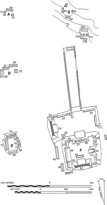
A sample of six unexcavated PP2 groups at Tikal of varying size, all presented at the same scale (derived from Carr and Hazard 1961). Excavated examples of PP2 are the subject of Tikal Report 21 (Becker 1999), in which examples intermediate in size between E and F are documented. (A) Group 6C-IV (Structures 6C-41/43). Typical small example; (B) Group 6E-XIX (Structures 6E-81/84); (C) Group 6E-XXXII (Structures 6E-139/142). A mid-size group situated adjacent and to the southeast of Group 6E-XIX. At Tikal, PP2 groups are rarely located together, except in two parts of the city (Becker 2003b); (D) Group 7B-X (Structures 7B-25/28); (E) Group 2C-XVIII (Structures 2C-73/78); (F) Group 6B-II (structures 2B-16/40). The Barringer Group, a “site”-size residential complex within central Tikal.
 You have
Access
- 15
- Cited by