

Introduction
Archaeological research in north-eastern Tunisia has traditionally focused on the ancient city of Carthage at the expense of its hinterland (Freed Reference Freed2011; Peña et al. Reference Peña, Rossiter, Wilson, Wells, Carroll, Freed and Godden1998). When the wider rural landscape has been investigated, these studies have largely concentrated on specific temporal periods rather than examining Carthage's regional landscape over the longue durée (van Dommelen Reference van Dommelen2006, 17; Ørsted et al. Reference Ørsted, Carlsen, Sebaï and Hassen2000). Joseph Greene's survey is unique among studies of Carthage's hinterland in that it sought from the outset to record from multiple time periods. The field survey was carried out between 1979 and 1983 as part of his doctoral research (Greene Reference Greene, Keller and Rupp1983; Reference Greene1986; Reference Greene and Ennabli1992). This survey covered a wide region, but was not intensive owing to the time, funding and personnel constraints of a doctoral research project (Stone Reference Stone1997, 85). The Carthaginian Countryside survey (CCS) investigated previously known sites and identified new archaeological sites dating from the Punic (sixth century BC) through to modern periods to address the development of Carthage and the usefulness of the Atlas archéologique de la Tunisie for relocating archaeological sites (Babelon et al. Reference Babelon, Cagnat and Reinach1893). French colonial officials, surveyors, and archaeologists produced this atlas in the late nineteenth century to map all known sites in Tunisia (Babelon et al. Reference Babelon, Cagnat and Reinach1893, ch. 3).
Greene's results have been used by scholars to investigate specific time periods of Carthage's rural settlement (Docter Reference Docter2003; Reference Docter, Helas and Marzoli2009; Greene Reference Greene, Keller and Rupp1983; Reference Greene1986; Stone Reference Stone1997), but the full potential of the data remains untapped. The survey was never comprehensively published and the site locations were gathered prior to the ‘digital revolution’ and thus are only available to researchers in the appendices of Greene's unpublished thesis. This paper discusses not only the importance of the CCS for understanding Carthage's regional landscape, but also demonstrates the ways in which the data can be integrated with modern studies of, for instance, the impact of the recent spread of urbanisation or of intensive agriculture threatening or destroying aspects of the archaeological record.
Regional field surveys across the Mediterranean world have demonstrated the utility of using a landscape perspective to document the large-scale and complex use of ancient environments (Bevan and Conolly Reference Bevan and Conolly2004; Mattingly Reference Mattingly1988; Ørsted et al. Reference Ørsted, Ladjimi Sebaï, Ben Hassen, Ben Younes, Zoughlami and Bejaoui1992; Witcher Reference Witcher2008, 22). Penelope Allison notes that large legacy datasets from surveys are particularly abundant in Old World archaeology and are valuable resources for addressing new archaeological questions (Allison Reference Allison2008, 10). ‘This term (legacy data) essentially means that these data are not already digitised and geo-referenced, but must be prepared, and often manipulated, before they can be used in a digital environment’ (ibid., 3). Whilst there are many ways to investigate and integrate legacy data within current research, geographic information systems (GIS) are ideal tools to catalogue, preserve, critically assess and analyse legacy data (Allison Reference Allison2008; Witcher Reference Witcher2008; Witcher and Craven Reference Witcher, Craven, Cascino, Di Giuseppe and Patterson2012). GIS has been used to preserve and analyse the CCS data by digitising Greene's appendices into shapefiles useable for a variety of researchers. In addition, GIS can further enhance our understanding of Greene's survey through visualisation and spatial analysis relating site location and attributes to physical features in the landscape. This paper discusses the digitisation of Greene's data and its importance in understanding the rural landscape of Carthage.
The Carthaginian Countryside survey
The majority of research at Carthage has focused on the ancient city using the results of archaeological excavation and/or information obtained from historical accounts (Freed Reference Freed2011; Lancel Reference Lancel and Nevill1997; Peña et al. Reference Peña, Rossiter, Wilson, Wells, Carroll, Freed and Godden1998). Although these efforts have considerably enriched the understanding of its development and occupational history (Docter Reference Docter, Helas and Marzoli2009, 179), there has been a comparative lack of attention paid to the surrounding rural landscape, despite the importance of the agrarian hinterlands to urban centres in pre-capitalist societies (van Dommelen and Bellard Reference van Dommelen, Bellard, van Dommelen and Bellard2008, 1). The understanding of Carthage's rural landscape is fragmentary at best, which impacts the interpretations that can be drawn about the past settlement patterns and landscape use around Carthage over the longue durée (Witcher Reference Witcher, Bowman and Wilson2011, 52).
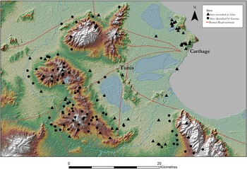
Greene's survey used archaeological surface reconnaissance survey techniques to investigate a 900 km2 area within a 30 km radius of the city to address this imbalance. The survey's primary purpose was to ‘locate, date, and analyse the pattern of ancient sites in the region of Carthage’ (Greene Reference Greene1986, 5), and the findings were used to better understand the connections between the rural hinterland and the city. The CCS used the Atlas archéologique de la Tunisie to locate sites that had been identified during geographic surveys of Tunisia in the nineteenth century (Figure 1), and searched the surrounding areas for additional sites (Babelon et al. Reference Babelon, Cagnat and Reinach1893; Greene Reference Greene, Keller and Rupp1983, 7). In using this methodology, Greene was testing the usefulness of the atlas in both relocating sites and for leading to additional discoveries; he examined 80 of the atlas's sites and identified 56 additional sites (Greene Reference Greene1986, 305–26). Greene defined a site as ‘a surface deposit of artefacts with coherent nucleus and definable limits’ (Greene Reference Greene1986, 5), and most of the sites were surface scatters of diagnostic ceramics.
The sites located by the Carthage survey from the Atlas archéologique de la Tunisie and new sites located by Joseph Greene.

A similar approach was initially undertaken by the Kasserine Survey (1982–87) in central Tunisia. For the first two field seasons, the survey methodology was relatively restrictive and investigated sites recorded by the Atlas archéologique de la Tunisie (Hitchner Reference Hitchner1988). However, this methodology was changed to a systematic field survey using ten metre-wide transects in selected one-square-kilometre quadrats owing to the limitations of the atlas for site discovery, at least in central Tunisia (Hitchner Reference Hitchner1988, 10–12; Reference Hitchner1992; Hitchner et al. Reference Hitchner, Ellis, Graham, Mattingly and Neuru1990). The Kasserine Survey indicates both the advantages and limitations of using the Atlas archéologique de la Tunisie, as during the first few seasons a number of sites were found using the atlas, but additional sites were identified once a systematic survey was adopted (Hitchner Reference Hitchner1988). This suggests the CCS strategy of relying on the Atlas archéologique de la Tunisie probably missed sites within the hinterland of Carthage.
The results of the CCS reinforced the importance of the local environment and climate for the growth of both Carthage and its rural hinterland, with the waxing and waning of site density across different time periods apparently tied to the cycles of agricultural intensification, especially during the Roman period (Greene Reference Greene1986, 273). The survey remains one of the most extensive fieldwork projects conducted around Carthage and has much to offer to the understanding of the development and evolution of Carthage owing to the aggregate data of sites across the region. Because of the nature of the survey, there are likely to be considerable areas which lack coverage and the pattern of site distribution may partly reflect the areas available for survey and the methodological choices undertaken by the CCS (Stone Reference Stone1997, 86).
Using legacy data
New research focusing on how the past landscape was understood and used have grown at the same time as the surface archaeological record has deteriorated due to erosion and intensified agriculture. This has led to a growing recognition that the use of legacy datasets is necessary to more fully contextualise the past (Witcher Reference Witcher2008, 5.1). Legacy datasets provide unique challenges due to their relative inaccessibility and the limitations of their metadata. How, when and why the legacy datasets were created need to be fully understood in order to effectively analyse the data and integrate them with modern research questions. Past field methodological decisions that at the time were appropriate can be difficult to understand decades later. It is necessary to appreciate these decisions as they directly impacted how the archaeological datasets were created and recorded.
In the case of the CCS data, one of the primary difficulties was digitising the sites’ locations based on the site catalogue descriptions (Greene Reference Greene1986, Appendix II). The catalogue detailed every site's location, date and size along with a description of the site (Greene Reference Greene, Keller and Rupp1983). The unique identifiers assigned to the sites’ spatial coordinates were written in a format that does not match any known coordinate system and the method of producing the identifier was not specified in the text, although it was stated they related to the geographic grid coordinates of the sites (Greene Reference Greene1986, 305–26). The coordinate system had to be determined prior to reconstructing the sites’ geographic coordinates and digitising them in GIS. It was hypothesised by the authors that Greene used French colonial maps of Tunisia to relocate the sites listed in the Atlas archéologique de la Tunisie, and used these maps to assign the unique identifiers. These colonial maps are difficult to procure as they have been superseded by maps created by the Tunisian mapping authority. A digital copy of the Institut Géographique National's (IGN) (1954) 1:50,000 map, Carte de Tunisie au 50.000, was sourced from the University of California, Santa Barbara, and georectified in order to correctly digitise the CCS results. This map was obtained and used as it appeared to be the best fit to match Greene's descriptions of the grid references he assigned to the sites (Greene Reference Greene1986, 305–6).
Once the digitised map was georectified, the process of identifying the site locations and digitising them could begin using ArcGIS 10.0. It quickly became apparent that Greene used an idiosyncratic system that transposed the grid coordinates from the IGN map and that the correct map had been located. For example, site 123's location in the catalogue was written 53/066 907 (Greene Reference Greene1986, 322). In actuality, the location was 5066 and 3907 using the IGN geographic coordinate system (Projection Lambert Nord, Tunisie) based on the Est du Méridien de Paris, which could only be determined when compared with the figures in Greene's thesis, the catalogue descriptions and the IGN map. This unique identifier may have been used to preserve the safety of the site's locations from looting by hiding the correct spatial coordinate.
By comparing the maps in Greene's thesis with the georectified IGN map and the deciphered site location identifier, it was possible to digitise the sites to their correct spatial location. Only sites with a grid reference were included in the analysis, which meant that four sites (51, 52, 53 and 49) were removed from the GIS database as no grid reference for these sites was provided in the site catalogue. It is important to note that the spatial accuracy of the site locations varied with some sites having eight-figure grid references (accurate to a location within a 10 m by 10 m area) and others six-figure coordinates (accurate to 100 m by 100 m). The sites are included in the appendix of this article as X and Y coordinates, converted into the Universal Transverse Mercator coordinate system. The site locations are in WGS 1984 UTM Zone 32 N and are accurate to 100 m by 100 m to allow other researchers access to the data while preserving extant sites from potential looting.
GIS analysis
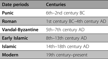
Once all of the sites had been located, a geodatabase was constructed to include the site attributes (Greene Reference Greene1986, 308–26); this included information on the site size, dating, and the type of remains along with whether the site was discovered by Greene or was originally recorded in the Atlas archéologique de la Tunisie. The dates of many of the archaeological sites in the database were changed due to adaptations in ceramic typologies since 1982 (Docter Reference Docter, Helas and Marzoli2009, 183–84; Fentress and Docter Reference Fentress, Docter, van Dommelen and Bellard2008). The sites were categorised by temporal period to correspond to the known cultural horizons of the region, and if they were occupied across multiple periods or only once (Table 1).
Dating periods used for this study.

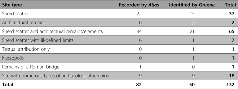
Every site was categorised by type based on Greene's catalogue (Reference Greene1986, 308–26) to identify the archaeological remains present at each site and whether the site was originally recorded by the Atlas archéologique de la Tunisie (Table 2). The majority of the sites were surface scatters of artefacts or artefact scatters combined with standing remains of architectural features.
Total number of sites in GIS database.

The GIS database was used to address three important questions related to the CCS site catalogue. These questions are by no means the definitive enquiries to be asked of the dataset, but rather are suggestive of the types of questions that can be addressed working with the Carthage dataset in GIS:
-
• Where were the sites located in relation to Carthage and to the physical environment? Were there any patterns or clusters of sites in certain periods if they were recorded by the Atlas archéologique de la Tunisie or by the CCS?
-
• What was the significance of the relative size of the sites? Are there any spatial patterns across the landscape based on size and time period?
-
• What is the relative loss of archaeological sites since Greene's survey due to urbanisation?
Carthage and its hinterland
One of the primary questions addressed by this analysis of the CCS was investigating the relationship of the sites to the physical landscape to reveal if there were any discernible patterns between spatial location and temporal period. A kernel density estimation was performed on the site locations to examine the relative density of sites across the landscape (Conolly and Lake Reference Conolly and Lake2006, 175; Wheatley and Gillings Reference Wheatley and Gillings2002, 166) (Figure 2). This analysis shows that the highest concentrations of sites were in the ancient boundaries of Carthage and along the western and southern boundaries of modern-day Tunis in the upland region known as the Djebel Aïn el Krima. Greene identified sites primarily outside of the boundaries of Tunis, while the sites identified by the Atlas archéologique de la Tunisie, unsurprisingly, were clustered in and around Carthage (Figure 2).
Kernel density analysis of the site distribution revealing areas of significant clusters of sites.

These concentrations may indicate that the upland zones were repeatedly chosen for settlement and use across the analysed periods. They may also be indicative that the sites in the rural margins and in Carthage are located in landscapes that have been preserved by either being protected (Carthage) or avoided by urbanisation and intensive cultivation (the rural margins). This lack of visibility of the archaeological record outside of these two zones has considerable implications for our understanding of the archaeology of this region. It is likely that this pattern has the potential to skew spatial analysis of the entire region and it may be more worthwhile to focus on the areas of higher site density. As this is the case for both the sites identified by Greene and the Atlas archéologique de la Tunisie it suggests this is a pattern which has considerable time depth.
A spatial analysis of the ASTER 30 m resolution DEM showed that there were broad patterns in the locations of the sites compared with the topographic relief. The majority of the sites, although in upland areas, were not located on steep slopes or on the highest elevated landforms in the region. Most were clustered in the drainage basins leading down to Tunis. The results suggest that flatter terrain was preferred for settlement and use even in the more mountainous portions of the study area, the majority of the sites were found on terrain with little to no relief. Related to this preference for relatively flat areas is that there does not seem to have been any intentional positioning of the sites on north- or south-facing slopes.
Of the 132 digitised sites, six were undated, 27 were from a single period, and 99 were multi-period sites (see Table 2). The high number of sites that had artefacts from multiple periods is intriguing, with few of the sites established in the earlier periods not revisited later. This pattern fits with Greene's interpretation that the relative growth of the number of sites in the rural hinterland aligned with the rise of Carthage in the Roman and Vandal-Byzantine periods before contracting in the Early Islamic period (Greene Reference Greene1986). The limited number of Islamic and modern sites could be reflective of this contraction or may be due to a lack of settlement or diagnostic material to identify sites.
Another aim of this investigation was to elucidate the relationship between the location of sites to reveal any survey bias and the possibility that sites were located along routeways. Of the 52 sites identified by Greene, 46 were located within 500 m of a modern road, which suggests that the discovery of the sites may have been partly a result of access to the survey regions by car or bus (Stone Reference Stone, Alcock and Cherry2004, 135). There are indications that the road network designed by the French colonial structure may have used the pre-existing transportation routes that can be traced back to the Roman period (Greenhalgh Reference Greenhalgh2014, 191–94). Thus the modern road network and Greene's data may be indicative of the use of the rural landscape during ancient times with settlement networks branching out from Carthage using ancient routeways.
Site size
The relative size of the sites was calculated using the CCS catalogue's size descriptions. These were established by Greene and based on dimensions of observed remains and reducing this size by 20 per cent to estimate the overall site size in hectares (Greene Reference Greene1986, 306). When separated by time period, it became apparent that there were continuities in site size across the Punic, Roman and Vandal-Byzantine periods (Figure 3). The larger sites in these periods generally were the site types that contained not just artefact scatters but a variety of architectural and structural features, with most of these large sites located along Roman roads leading to Carthage (Roman road network obtained from the Harvard Digital Atlas of Roman and Medieval Civilizations, McCormick et al. Reference McCormick, Huang, Zambotti and Lavash2013) (Figure 3), suggesting these were regional centres that supplied Carthage. It is probable that these stable, large settlements along the Roman road networks were important aspects of the rural network that supported the city, although the size of a site does not necessarily reflect importance.
The relative size of the archaeological sites according to date period.

Only 26 sites were located within 500 m of modern water sources, but all of the large sites identified in the catalogue were located close to rivers, lakes or the coast. Water supply would be essential for established settlements and for intensified agriculture in the region (Peña et al. Reference Peña, Rossiter, Wilson, Wells, Carroll, Freed and Godden1998). The relative size of the settlements observed by Greene compared with the results of the site analysis of proximity to roads and water sources suggests there were long-lasting ‘hubs’ in the rural support network of Carthage that demonstrated continuities across the Punic, Roman and Vandal-Byzantine periods. Although this may be too much of an interpretive leap considering the results are based on surface survey, these findings suggest intriguing ways that legacy data can be compared and contrasted with modern studies of the region.
Urbanisation and the Carthaginian Countryside survey dataset
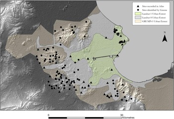
Although it has been noted that the urban growth of Tunis probably affected the sites recorded by Greene (Docter Reference Docter, Helas and Marzoli2009, 182), GIS can quantitatively analyse this impact. Data obtained from NASA's Socioeconomic Data and Applications Center (SEDAC) and Columbia University's Center for International Earth Science Information Network (CIESIN) Global Rural-Urban Mapping Project (GRUMPv1) provided a raster representation of urban areas across the world. The GRUMPv1 mapped urban areas based on a combination of population, settlement points, and the presences of night-time lights visible in satellite imagery (CIESIN 2011). This dataset produced an urban region centred on Tunis of approximately 150,000 hectares that contained 76 per cent of the sites identified by the CCS (101 of 132 sites) (Figure 4).
The changing urban extent within the survey area since the original survey (Landsat 1) to the present (Landsat 8 and GRUMPv1) relative to the known archaeological sites.

This mapped urban area covered the greatest extent of the urban zones centred on Tunis, including surrounding suburban development and villages. As such, there are gaps within the GRUMPv1 urban zone that are agricultural or contained limited urban development. In order to refine the mapped urbanisation of Tunis, satellite imagery from 2015 (Landsat 8) and 1972 (Landsat 1) was obtained from NASA's archive of Landsat imagery (Landsat 2016). Polygons were digitised using the Landsat imagery that defined the built environment of Tunis based on areas that could be seen on the aerial imagery containing structures and road networks (Nebbia et al., Reference Nebbia, Leone, Bockmann, Hddad, Abdouli, Masoud, Elkendi, Hamoud, Adam and Khatabforthcoming). The 1972 Landsat 1 data (which was the highest resolution Landsat image of the Tunis region closest to Greene's survey in time) demonstrated a relative urbanised zone of 26,000 hectares that contained built-up roads, buildings and neighbourhoods. This grew by 2015 to a relative size of 62,000 hectares, indicating that the Tunis metropolitan area has grown by almost two and half times since Greene's survey.
The Landsat imagery aligns with the population statistics of Tunisia, which grew from 5,099,000 to 9,816,000 between 1970 and 2000 (Winckler Reference Winckler2005, 42). This large boom in population was felt most in Tunis, the capital and largest metropolitan area. The growth in the urban sprawl around Tunis undoubtedly affected the archaeological sites identified during the CCS. Of the 132 sites, 24 were located within the 1972 urban boundaries. By 2015, this number rose to 55 of the 132 sites within areas that are directly built up. In addition, the 2015 Landsat shows significant agricultural intensification around Tunis, and the remaining 77 sites are located within this area. The satellite imagery and population statistics demonstrate the significant changes to the landscape that occurred since Greene's fieldwork in the early 1980s. Although the amount of site destruction that has occurred based on this urban growth is unknown, unchecked urbanisation generally adversely affects archaeological remains. This is especially true for the CCS that contained a large percentage of sites (80 per cent, n = 105) comprised of artefact scatters on the ground surface that would be particularly susceptible to urban growth and intensified agricultural practices. The importance of Greene's survey work, therefore, is not only in understanding the past use of the landscape, but also in recording the presence of sites that probably are now lost.
Conclusion
This paper has demonstrated the importance of revisiting legacy datasets, as they have much to offer modern evaluations of past landscapes. This is especially true when using spatial technologies to both preserve and reinterpret the past. The GIS analysis of the CCS has demonstrated unique patterns where sites were spatially located compared with transportation networks, water sources and topography, and with the built-up urban regions of Tunis that both build on and complement Greene's and Stone's analysis of the site patterns. Settlements were located in specific areas of the landscape to take advantage of the environmental and socio-economic resources within the region, and these can be analysed and interpreted using spatial technologies and remote sensing techniques. In order to understand this past land use, we must incorporate legacy data to more fully contextualise modern studies and research. That said, legacy data should not be used simply to supplement newer data; it should be critiqued and interrogated.
The sites recorded by the CCS are a limited representation of the original occupation history of the region. Sites are relatively absent from the central area, which is probably indicative of the urban sprawl of Tunis and Carthage in the early 1980s and not reflective of past settlement and land use. In a way, this reinforces the importance of revisiting the CCS, as the urban growth of Tunis has enveloped much of Greene's survey region and this urban sprawl has impacted the archaeological landscape. Thus our main data source for understanding Carthage's hinterland, now under built-up Tunis, is by investigating past datasets. This is a body of data which has been underutilised by archaeologists, although it has been acknowledged by scholars that we need to be not only aware of this data but actively incorporating them into modern analyses (Allison Reference Allison2008; Witcher Reference Witcher2008; Witcher and Craven Reference Witcher, Craven, Cascino, Di Giuseppe and Patterson2012). The analysis conducted here has revealed that the study of legacy data is rarely straightforward; however, there is considerable potential to expand our archaeological knowledge through the analysis of this data.
Acknowledgements
First and foremost, gratitude is due to Dr Joseph Greene and his extensive survey in the Carthage hinterland creating the dataset used for this article. In addition, we are grateful to the support of Dr Anna Leone for encouraging us to investigate this project, and for the comments and critiques of the peer reviewers. This paper grew out of a guided study during Rachael's graduate studies at Durham University led by Brian.
Appendix