INTRODUCTION
Ponds, where humanly constructed, are a familiar component of the present-day landscape, often now enjoying special status for their biodiversity, while their history is usually little regarded. Existing smaller and medium-sized examples are probably of medieval to modern date,Footnote 1 with those of pre-modern date having seen a constant effort to re-establish the pond, as they have a natural tendency to silt up. Such features are also encountered archaeologically, when there is a general awareness that they might well contain waterlogged environmental deposits significant for the reconstruction of Holocene landscape history, as well as organic, structural and artefactual remains.Footnote 2 Generally, however, ponds are quite difficult to study, most obviously for the very practical reason that fieldwork on such wet sites presents particular archaeological challenges, which makes their recording and sampling a demanding task. As part of their better appreciation, this article seeks to review a sample of proven Roman ponds following the full excavation of a large part of one example from Worcestershire, while also considering what they might contribute to our understanding of Roman rural settlement.
Some definition may be useful to start with. The type of pond being considered here is the smaller expanse of permanent water, with an easy gradient around a good proportion of its margins and ideally most suited for stock watering. Water-holes, distinguished by having a steeper profile, a greater depth than the usual pond and a diameter-to-depth ratio which is relatively similar, are excluded. These latter have more often been associated with prehistoric sites, though they are also known from the Roman era, as for example in the Upper Thames valley at Cotswold Community, c. 5 km south of Cirencester,Footnote 3 and at Claydon Pike (Glos.);Footnote 4 they can sometimes be quite large in the Roman period, as at Leavesden (Herts.), which measures 15 by 11 m and 1.5 m deep.Footnote 5 There are also sites where the attributes of both pond and water-hole seem to be combined; these include, in a prehistoric context, the late Bronze Age example at Heathrow (Middlesex)Footnote 6 and, in the (later) Roman period, that at Shiptonthorpe (Yorks.).Footnote 7
In earlier times there is considerable uncertainty about the extent of humanly constructed ponds, and, prior to the Roman period, it seems that natural wetlands, including stream- and river-sides, provided for most of the needs that such features might supply. Ponds seem to be first recognised, though fairly tentatively, in the Iron Age (as at Heathrow),Footnote 8 though even when they are so identified, they tend to be dew ponds. They are not explicitly mentioned in Barry Cunliffe's survey of Iron Age settlement across Britain.Footnote 9
To understand the Roman pond in its wider chronological context it is also necessary briefly to survey later periods. There is a marked contrast with the medieval period, where the use of water in artificial schemes is represented by a large number of mills, fish ponds and other works involving ponds, though there is still much uncertainty about how many ponds were available in the countryside for other, less elaborate uses, such as watering stock. A general survey of the location and dating of all existing ponds in several Cambridgeshire parishes concluded that most should be assigned a medieval or later date in association with watering stock and aiding drainage, though their origins remain unknown.Footnote 10 A correspondence with a specific geology (i.e. clay) and an increasing incidence away from the main watercourses were generally noted, with many of the ponds being just over 1 km from a good natural water source.Footnote 11 This, at least, provides a useful idea of the distribution of ponds to compare with other periods. Along similar lines, GIS mapping of wetlands in Worcestershire, based on cartographic sources, has identified a concentration of small (undated) ponds on clay soils in the east of the county, which were probably used for stock watering, with many of the other examples being fish ponds and mill ponds generally identified on the HER as being of medieval or later date;Footnote 12 this too provides another dataset concerning the possible historic distribution of ponds.
Only in the post-medieval period is there greater confidence about ponds being created on a large scale in the wider countryside, whether as features within country estates, or as components of field-systems. In the West Midlands this is often considered a by-product of the marling of arable fields, though the watering of plough-teams would also have been a requirement; thus stock rearing need not be the only explanation for such features, especially where they are set away from centres of habitation. These numerous pits/ponds still exist in many cases, though in truth their date of origin is much less clear than might be assumed, as they have been little studied and, in an excavation context, they can often be entirely ignored.
Judging from archaeological examples, therefore, ponds seem to have differing character and frequency in each period. Within the Roman period, discussions of hydraulic engineering achievements have tended to focus on major schemes, such as the baths at Bath,Footnote 13 the supply of water to villas and towns by aqueduct, or the modification of stream courses, as at Bancroft (Bucks.), to create a head of water to drive a mill.Footnote 14 Examples of smaller ponds being created and used in the Roman period seem to be relatively rare, though being smaller they will have tended to silt up gradually and disappear, hence they can only be recovered by archaeological investigation; it is this type of pond which forms the subject of the article. It is also likely that such ponds were not as rare as they might currently seem, given that the historic focus of archaeology has typically been on river terrace deposits, where alternative ways of watering stock were always available. As a result, few sites on a clay subsoil or in topographically similar landscape positions to that at Wyre Piddle (i.e. along more elevated spring lines) may have as yet been discovered.
ROMAN POND AT GEORGE LANE, WYRE PIDDLE, WORCESTERSHIRE
The pond at George Lane, near Wyre Piddle (SO 9707 4808; figs 1–3), was part of a larger concentration of Roman features excavated in 2005–6, beyond which lay contemporary field/enclosure ditches and a cremation. Evaluation trenching had identified the presence of the pond, but this was insufficient, as first designed, to establish its full extent and so it was supplemented by auger survey. Excavation was then carried out, so as to include that part of the pond which fell within the development area.
Site location. (Copyright and reproduced by permission of the Ordnance Survey; licence 100024230)

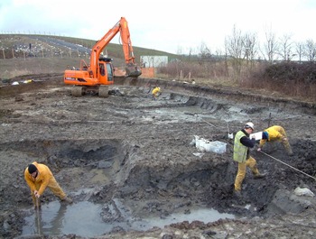
Pond (CG5) during excavation with fills exposed (viewed from west). The pond edge runs from front left to beyond the mechanical excavator, fills continuing beyond site edge to the east.

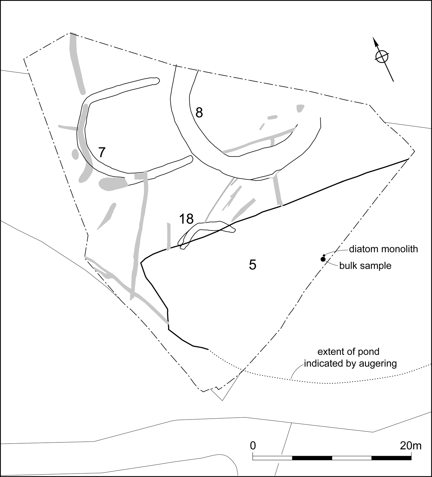
Phase 2a plan (north area of excavation only; shaded features are later truncation).

The pond (Context Group (CG) 5; figs 2–3) had been spring-fed, as became apparent during excavation, and was situated just above the flood-plain of the river Avon, at a height of c. 27 m AOD on Jurassic clay geology. It was a substantial feature and was only partially excavated, as it extended off the site to the south and east. Even so, a large portion (c. 75 m3, with maximum dimensions of 33 by 15 m and a maximum depth of 1.5 m) was fully excavated. It had been a sizeable body of water and seemed to have been an entirely new feature in the landscape, with no indication that any natural depression had been modified or enhanced; its artificial nature was further confirmed by the recovery of finds from throughout its depth. The northern edge was the most clearly defined, a slope of 20–24 per cent being in evidence.
Excavation was difficult due to the clay geology and to the very wet conditions, the latter being unsurprising given that the original spring still flowed; such problems were further exacerbated by the work being undertaken in the winter. The decision was eventually taken to fully excavate the available area of the pond, with pumping being necessary to achieve this. The pond fills were excavated in 0.3 m spits, reflecting the difficulty of distinguishing individual fills (cf. fig. 4), and on a 3 by 3 m grid from the highest point of the fills (cf. fig. 6); the finds were retrieved by a combination of hand and machine digging, with a lot of effort being expended to maximise retrieval in the face of difficult circumstances. As a result some smaller finds will inevitably have been lost, though, overall, collection was considered to have been good.
Cross-correlation of auger-hole B5, excavated spits, and monolith 1 in the pond (CG5; for locations see fig. 3). Monolith layers: 1, mid-grey clay; 2, mid-black clay; 3, light grey organic clay; 4, desiccated peat.

The results derived from the pond could fortuitously be studied alongside those from a clutch of other recently excavated Roman sites in the same general area, which provided an opportunity to characterise the landscape in this part of the Avon valley during the Roman period.Footnote 15 Such an approach has meant that the pond was not seen just as an isolated feature. The palynological study, in particular, by reaching out into the surrounding region and making connections with other Roman sites was able to provide a more robust account of landscape use through time.
The pond was generally associated with an appreciable quantity of finds, especially pottery and animal bone, when judged against other rural Roman sites in this region. This quickly drew attention to the feature and forms a principal focus of the resulting interpretation of the site. Interpretation also initially focused on the spring-water having an appreciable chloride level (the concentration of total dissolved sodium chloride would be 1.85 gram/litre), though this was later discounted as being far too low to be really significant.
The detailed archive report is available on OASIS.Footnote 16
THE SITE
Roman site phases associated with the Wyre Piddle pond are briefly summarised below, with the description concentrating on the disposition of features on that part of the site adjacent to the pond, which was clearly a founding feature and so an original site component ( fig. 3):Footnote 17
Phase 1 (?late Iron Age/early Roman): a possible circular enclosure or roundhouse (ditch/gulley internal diameter c. 15 m; CG8) with a horseshoe-shaped annex (CG7) to the west on the same alignment as the northern edge of the pond.
Phase 2a (mid- to late first century a.d.; fig. 3): the original circular feature was substantially recut (CG8; internal diameter c. 14 m) bringing it closer to the pond.
Phase 2b (early to c. mid-second century): the annex was replaced by an enlarged compound constructed of segmented ditches, while the larger features (circular ditch and pond) showed evidence of activity (i.e. deposition).
Phase 2c (later second/early third century): the circular feature had now been infilled and ditches had been dug across the infilled pond, with this area no longer being an obvious focus of activity.
When viewed in plan, the pond, the circular feature (?roundhouse) and its annex appear to share a similar orientation, suggesting that they formed a coherent unit, an impression which was fully compatible with the finds dating. There were, however, no internal features to corroborate the identification of the roundhouse, though this was considered a more likely function than an open enclosure. The pond, therefore, seems to form a principal component of this group of features. In addition to the usual range of domestic material culture, there were finds indicative of craft activities (bone working, iron smithing, and possible tesserae manufacture), though none of these could be placed at the site itself.
Any late Roman presence was quite negligible (e.g. an unstratified coin dating a.d. 310–16). As for other periods, the only indication of pre-Iron Age activity was a small amount of worked flint, while post-Roman activity was represented by medieval and later cultivation features, the latter contemporary with a trackway, but all on a different alignment from the Roman phase of activity; this demonstrates that the Roman remains had been subsumed back into the natural landscape. The pond, and its associated Roman activity had, therefore, constituted a discrete, but short-term, episode of activity.
THE FINDS FROM THE POND
By the standards of this part of the West Midlands the quantity of finds was substantial. There was also a good stratigraphic sequence, with the pond fills demonstrably well sealed by a medieval trackway. Detailed study of the assemblage demonstrates that it also had some unusual characteristics, which were additionally associated with a range of environmental indicators revealing the wider contemporary landscape.
Artefactual evidence By Laura Griffin and Derek Hurst
The following is an abbreviated summary of the artefactual evidence from the pond (CG5).Footnote 18
Phase 1
The thin basal layer (2019) was noticeably organic and there were relatively few finds, with the pottery all being locally made Malvernian handmade ware (Fabric 3) which dates either side of the Conquest. There was also some animal bone and fuel ash slag.
Phase 2a
The lower silting of the pond (2004) contained mainly pottery, predominantly Severn Valley ware (jars and drinking vessels), with some of the Malvernian handmade ware now imitating early black burnished ware (BB1). Other finds included clay oven pieces, fuel ash slag, ceramic roof-tile, and animal bone.
Phase 2b
The infilling of this large feature seemed to continue gradually over time, as there were no obvious signs of recutting or desilting. Throughout the sequence the date of the finds was broadly consistent with their increasing depth. During this phase there was a great deal of deposition in the pond both in terms of silting and the addition of material through human agency. As this latter was found throughout the depth of the fill, it seems likely that it was being added during silting rather than being deposited while the pond held water; had this latter been the case, most of the finds would have accumulated at one level with silting only following final abandonment. The incorporation of so much artefactual and ecofactual material would seem to indicate that it was no longer functioning as a useful pond during much of Phase 2b. Due to its potential relevance to any interpretation of the feature's function the finds sequence in these final deposits is described in more detail as follows (see fig. 4):
-
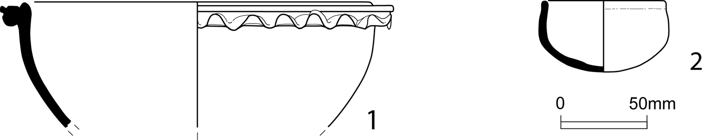
• 2003: a great deal of pottery and animal bone, together with some fired clay (including more oven pieces), ceramic objects (Malvernian slab-built components of an ?oven), coal, at least three smithing-hearth bottoms, miscellaneous ironworking slag and some fuel ash slag. A tazza ( fig. 5.1) came from this deposit (grid square C3; fig. 6). For dating purposes the samian with a terminus post quem mainly of a.d. 120 and the second-century BB1 were the most useful, while by this period Severn Valley ware was predominant, accounting for 71 per cent of pottery at this level.
-
• 2002: a great deal of pottery, animal bone, at least one smithing-hearth bottom, a small amount of miscellaneous ironworking slag and fuel ash slag (and possible hearth lining). For dating purposes the samian with a terminus post quem of a.d. 150 and mid-second-century BB1 were the most useful.
-
• 2001: a lesser amount of pottery and animal bone compared to the spits below, but the BB1 present still suggested a second-century date.
1: a tazza of curved profile type; 2: unusual small, round-bottomed vessel (i.e. designed to have been held in a stand) with distinctive internal blackening indicative of its use as a lamp. Both vessels are in oxidised Severn Valley ware.

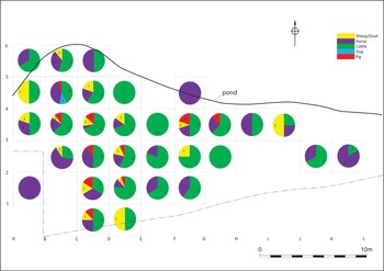
Identified animal bone (NISP) from pond deposits by grid square.

Phase 2c
The ditches succeeding the infilled pond were not associated with pottery any later than the latest material in the pond. This suggests that occupation activity had essentially ceased here and that only residual finds would work their way into features. One of these was an unusual lamp ( fig. 5.2).
Discussion
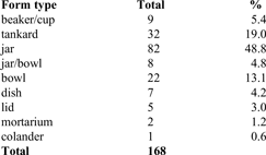
Infilling of the pond incorporated much pottery (predominantly Severn Valley ware drinking vessels and jars), clay oven fragments, ceramic roof-tile, fuel ash slag, iron-smithing waste (including coal) and animal bone, with finds being distributed throughout the depth of the fill. Such an accumulation of finds must have served to speed up infilling in Phase 2b. The finds were less dense in the top fill than in the deposits below. Overall the assemblage was notable for quantity rather than any obvious special character, though the incidence of drinking vessels did seem much higher than usual, amounting in the case of tankards, beakers and cups to c. 25 per cent of pottery vessels quantified by minimum number of vessel type (Table 1) and with a number of tankards being relatively complete; there were also two fairly unusual ceramic items, a tazza and a lamp ( fig. 5, 1–2). The method of quantification applied in the case of this assemblage was necessary due to a low occurrence of rims (despite there being large proportions of individual vessels), which ruled out a more conventional approach.
QUANTIFICATION OF POTTERY FROM MAIN POND FILLS (CG5, PHASE 2B), BASED ON MINIMUM NUMBER OF IDENTIFIABLE VESSEL FORMS

Though the site is situated in an area (Severn Valley) where a higher than usual proportion of drinking vessels has been suggested,Footnote 19 closer scrutiny indicates that this only rarely exceeds 20 per cent,Footnote 20 with most sites tending to be in the range of 10–20 per cent.Footnote 21 The high proportion of drinking vessels at the Wyre Piddle pond (c. 25 per cent) is thus striking. In a much wider context Jeremy Evans, in a survey of functional vessel categories across a range of site types and throughout the Roman period, albeit in northern England, also shows that drinking vessels rarely exceed 20 per cent of ceramic assemblages.Footnote 22 The few cases where they do exceed 20 per cent are thought to include ritual sites (e.g. the third-century Carrawburgh Mithraeum at 44 per cent and 50 per cent in successive phase groupings),Footnote 23 though military sites can also feature in this way (e.g. Flavian Brithdir at 25 per cent and Flavian Segontium at 23 per cent); urban and military sites generally tend to have more drinking vessels than rural settlement sites.Footnote 24 The Wyre Piddle pond clearly has no military association and so interpretation, based on just this one aspect of the artefactual evidence, might potentially favour a ritual purpose.
Animal bone By Sylvia Warman
Overall, the pond (CG5) yielded around half of the identified animal bone assemblage (by weight) from the whole site excavation.Footnote 25 The animal bone from the pond was well preserved compared with that from other features, much of it being identifiable to species (Table 2). Both cattle and horse showed a full range of body parts and the minimum number of individuals values (MNI) provided an estimate of the number of living animals required to create the assemblage. A much wider range of cattle and horse body parts was disposed of in the pond than for sheep/goat. Pig and dog were present in much smaller quantities and represent just a handful of animals.
ANIMAL BONE FROM POND (CG5) DEPOSITS – ALL PHASES
(NISP, number of individual specimens; MNI, minimum number of individuals)

For the purpose of spatial analysis, the Phases 1–2b pond assemblage is presented by grid square in fig. 6, with NISP (number of identifiable specimens) values given by species. Where phase assemblages were sufficiently large these comprised cattle, horse, pig and dog (P2a) and cattle, horse, sheep/goat and pig (P2b), the latter being the greatest quantity of identifiable animal bones from the widest range of grid squares. Overall there was a greater dominance of cattle bones in the north-west corner of the pond ( fig. 6, grids A3–5, B3–5, C3–5 and D3–5), but well away from the edge of the pond, with horse bone more numerous along the margins of the pond. Pig and dog were only present in very small quantities, rarely occurring on the pond margins and instead tending to be found towards the middle of the pond. Therefore, a trend can be demonstrated where the bones of a greater range of smaller animals are located towards the pond centre.
Several other observations can also be made based on closer study of the bone itself. The intensive and ubiquitous system for butchering of cattle bones identified in Roman animal bone assemblages was not found at Wyre Piddle; this has usually been interpreted as relating to bone marrow extraction, where the bones have been split in the transverse rather than longitudinal plane, and is particularly evidenced at large urban sites.Footnote 26 In which case the Wyre Piddle pond assemblage may reflect the earlier stages of carcass reduction (this is the process of the utilisation of the parts of an animal starting with the complete dead body of the animal),Footnote 27 rather than the more intensive stages of butchery. Possibilities, reflecting this pattern of butchery, are where animals had died from disease rather than deliberate slaughter, where there was a need to dispose of spoiled joints, or where they were killed for feasting. In any case why these remains should be deposited into the pond was unclear. If, as indicated by occasional articulation, the material deposited into the pond still had some soft tissue attached, it surely post-dated any use of the feature as a water source.
Discussion, including comparison with other sites
No parallels for such a large, well-preserved and well-dated Roman animal bone assemblage, and certainly none with similar characteristics (i.e. low levels of butchery), as at Wyre Piddle, were available locally. Looking further afield, a large well-preserved assemblage of cattle and horse bones showing low levels of butchery has been located at Nantwich, where salt production was carried out.Footnote 28 The low levels of salinity in the spring water at the George Lane site today, with no reduction since the Roman period being expected, and the absence of any other obvious indicators of salt production, suggested that the features at the two sites served different purposes. There are, however, some notable similarities in the animal bone assemblages, indicating that both may form structured deposits. The lack of intensive butchery, that would be expected to be seen in household food waste, characterises both assemblages. The long bones have not been split vertically to remove marrow; when they are broken, it is across the mid-shaft area. The presence of so many large bones from large domestic species, and with relatively low levels of fragmentation, is common to both assemblages. Both assemblages have indications that joints of meat or even partial carcasses were deposited at one time. The Nantwich assemblage, with a substantial component of cattle skulls, as well as fore and hind limb bones, is interpreted as including both ‘opening’ and ‘closing’ deposits. The Wyre Piddle pond assemblage has fewer skull pieces (although there are several mandibles from cattle), but a great number of limb bones, particularly from the hind limbs. Thus a possible interpretation is that the animal bone assemblage, at least in part, represents a ‘closing’ deposit, marking the point at which the pond went out of use for watering livestock. The absence of a similarly framed opening deposit is likely to reflect good husbandry, as incorporating decomposing carcasses at that stage would not have suited any practical use of the pond for watering stock, which is considered to have been its most likely purpose. Other Roman water sources, such as wells, also often included structured deposits which have been interpreted as symbolic of the closure of the feature as a water source, for instance where dog skulls have featured at Silchester.Footnote 29 However, while the Wyre Piddle pond assemblage included dog mandibles and teeth, there were no skulls.
Another explanation could be that the animal bones were deposited as a result of feasting activity, as represented by the lack of butchery relating to the preparation of bulk quantities and possible over-supply. Similar assemblages of comparable date have been identified in the Netherlands where feasting has been proposed as an explanation,Footnote 30 though somewhat at variance with the suggestion that horse was not widely consumed at this time.Footnote 31 British examples of animal remains interpreted as evidence of feasting activity are generally dated much earlier, as, for instance, at High Post (near Salisbury, Wilts.; 470–390 cal b.c.),Footnote 32 where a large number of minimally butchered cattle, sheep/goat, pig and horse bones were found in a deposit associated with an enclosure.Footnote 33 Deposits of horse, cattle and pig bones have been recovered in association with the Iron Age chariot burials at Ferrybridge (W Yorks.), indicating that all these species held ritual, as well as economic significance, to the Iron Age inhabitants.Footnote 34 It is possible, therefore, that the animal bone from the pond indicates that practices more typical of the Iron Age were continuing in the countryside among the Romano-British population.
Environmental evidence By Nick Daffern and Katie Head (pollen); Andrew Mann (mollusca); and Elizabeth Pearson (plant macrofossils and overview)
An extensive suite of environmental investigations was undertaken. However, plant macrofossils were not well preserved, indicating that waterlogging had not been continuous, though what there was did indicate a wet locality. The molluscan and pollen evidence complemented each other and so provided a good basis for landscape reconstruction.Footnote 35
The palynological evidence from the pond sequence (see fig. 4 for sample locations) indicated an open, grassland landscape which was pastoral in character from the beginning of the sequence.Footnote 36 The domination of pasture and grassland herbaceous species tends to indicate that the open character of the landscape was well-established suggesting an element of management, most likely in the form of animal grazing, thereby giving rise to a rich grassland habitat. This is supported by the diversity of the recorded grassland and pasture pollen taxa.
This open, pastoral landscape has previously been identified in other palynological investigations undertaken along the Avon valley, such as just to the south of the present site,Footnote 37 at Salford Priors 18 km to the north-eastFootnote 38 and at Broadway 23 km to the south-east.Footnote 39 All these sequences have shown a similar domination by herbaceous species. Concomitantly the contribution of tree and shrub throughout the sequence is relatively low, suggesting that there were just peripheral pockets of established woodland within the environment, as indicated by the presence of oak, ash and lime. Pollen also indicated that the pond itself was permanently wet in the Roman period. That the grassland came right up to the pond is indicated by the molluscan evidence being dominated by open-country species, indicative of dry, short-sward grasslands, including where trampled and heavily grazed.Footnote 40 One species even very subtly suggests that the grassland had been cattle- rather than sheep-grazed.Footnote 41
The environmental evidence from this site, has, therefore, consistently and strongly reinforced the evidence for a largely pastoral landscape in this part of the Avon valley in the later prehistoric and Roman periods (at least up to the late second century); this despite an initial assessment which had suggested low levels of each category of environmental remains from the Wyre Piddle pond deposits, and the poor preservation of organic remains from the deeper waterlogged deposits which had originally appeared visually promising. Such a situation may be typical of relatively shallow, near-surface deposits (see also below), which have suffered periodic desiccation, such that the full suite of environmental archaeological analyses needs to be applied to remedy this. A single pond, therefore, can still have the potential to provide information about the wider landscape over a longish period, compared with other smaller features, and can be key to setting any neighbouring sites within their general environmental context, while also significantly informing their interpretation as well.
PURPOSE OF THE POND
While it is accepted that the instigation, use and then demise of the pond may, of course, have arisen from a variety of different purposes, various possible uses can now be considered. One concerns any association with a productive purpose. While the slight salinity of the spring had initially encouraged some to favour a salt-production site, this now seems inherently implausible given the very low level of salinity and the lack of fired-clay structures other than fragments from the more typical domestic ovens. At known inland salt-making sites positive indicators were more evident, for instance at Nantwich,Footnote 42 where the main reservoirs were also more elaborately constructed with a timber lining to stop the collapse of the sides of a large tank, thereby providing a more convenient working platform around the edges, with the brine being purified by standing.Footnote 43 Though some aspects of the animal bone assemblage at NantwichFootnote 44 seemed similar to that in the Wyre Piddle pond, on detailed comparison there seemed no reason to link together the primary function of the two sites. However, both animal bone assemblages do include evidence that they may have constituted structured deposits, with the Wyre Piddle pond assemblage being more likely to represent a closing, rather than an opening deposit.Footnote 45 Another possible productive use might be as a stew pond, but this was dismissed as unlikely, given that no fish bone was noted. Despite the association with iron-smithing debris there was also no obvious direct functional link to explain the need for such a large water supply, especially since, in the absence of hammerscale, this activity was not otherwise located at the site.
Turning to other uses: religious activity in the vicinity might possibly be signified by the tazza vessel and the lamp, both of which are unusual for the West Midlands and both have also been regarded as indicative of funerary contexts and, on occasion, temples.Footnote 46 However, where such shrines have best been recognised there have been other very obvious indicators, such as very large quantities of bone usually from specific animals or birds (e.g. Uley, Glos.)Footnote 47 , while such sites as originated in the Iron Age often became clear foci of donative activity in the later Iron Age, frequently involving coins.Footnote 48 A pit on the very edge of the pond (CG23) contained the remains of a two-year-old horse. However, there was really no convincing evidence of substantive religious activity focused on the pond.
On balance, therefore, taking the accumulated wider environmental evidence as the chief indicator, the principal original purpose of the pond was likely to have been for watering stock in a grassland landscape and off the floodplain where water would have been at a high premium for grazing animals, especially cattle. The absence of evidence for processing agricultural products (e.g. hemp or flax) or cereal cultivation in the vicinity firmly corroborates this impression of a pastoral landscape. The sense of a highly managed landscape is also strongly conveyed by the complete lack of any remains of wild animal species.
The ultimate end of the pond in the mid- to late second century may, however, have occasioned some change of use representing a special activity. The animal bone assemblage was certainly somewhat out of the ordinary, not just in terms of quantity and quality, as in the case of the artefactual assemblage, but also in terms of the character of the material itself, which seemed to rule out its being ordinary domestic waste, especially as some sizeable portions of articulated animal were noted. If it was not random discard of unwanted parts of animals following limited butchery, then it would seem possible that the remains represent one or more feasting events at least towards the end of the life of the pond (Phase 2b). The great amount of pottery (including many near-complete vessels), especially drinking vessels (c. 25 per cent; mainly tankards, and amounting to c. 40 per cent of the Severn Valley ware assemblage by minimum vessel count), also added to this impression. Feasting is increasingly a theme that finds echoes in the archaeological record. Animal bone assemblages on a large and extravagant scale have been taken as an obvious indicator, which has been recognised for some later prehistoric sites,Footnote 49 as have larger quantities of animal bone and ceramics with a preponderance of drinking vessels (Iron Age Mas Castellar, Spain).Footnote 50 However, feasting has not been particularly associated with the Roman period.
ROMAN PONDS IN GENERAL
Natural ponds/lakes will have formed part of the landscape in some parts of the country due to entirely natural phenomena, often glacial in origin but also fluvial, accidents of geological impacts on topography, or where poor drainage occurred. The artificial pond, by contrast, was usually a much smaller affair which could occur anywhere, though obviously it would be most useful with increasing distance from a natural source of water. For the Roman period it can be suggested that the artificial creation of a pond was relatively infrequent. Where encountered at this period they tend to fall into five main categories:
-
(a) Swimming pools, usually attached to bath-houses, as for example at Gadebridge Park villa (Herts.), where the pool was 20 m long.Footnote 51
-
(b) Fish ponds (piscinae) which were usually ornamental and solely for prestige.Footnote 52 Unsurprisingly, therefore, examples are known from villas, for example at Bancroft near Milton Keynes (Bucks.);Footnote 53 they can sometimes be quite large as at Halstock (Dorset), where the pond is c. 14 m long,Footnote 54 though such structures have occasionally been assigned to fish-farming, as at Shakenoak villa (Oxon.)Footnote 55 and Claydon Pike villa (Glos.).Footnote 56
-
(c) Ponds at shrine sites, such as at Ivy Chimneys, Witham (Essex),Footnote 57 where metalwork deposition is a primary indicator, as well as animal remains, in this case butchered horse being prominent.
-
(d) Agricultural ponds, potentially used for a variety of purposes, possibly including flax and hemp retting, as well as for the watering of stock. The Wyre Piddle pond has been interpreted as an example of this latter use.
-
(e) Secondary ponds created as a result of quarrying extraction (especially clay) and so associated with industrial sites, as at Madresfield (Worcs.) in the course of pottery productionFootnote 58 and at Wootton villa (Northants.) in the course of various third- to fourth-century industrial activities.Footnote 59 These can display a gradual slope on one side, where access was achieved for the extraction of raw material.
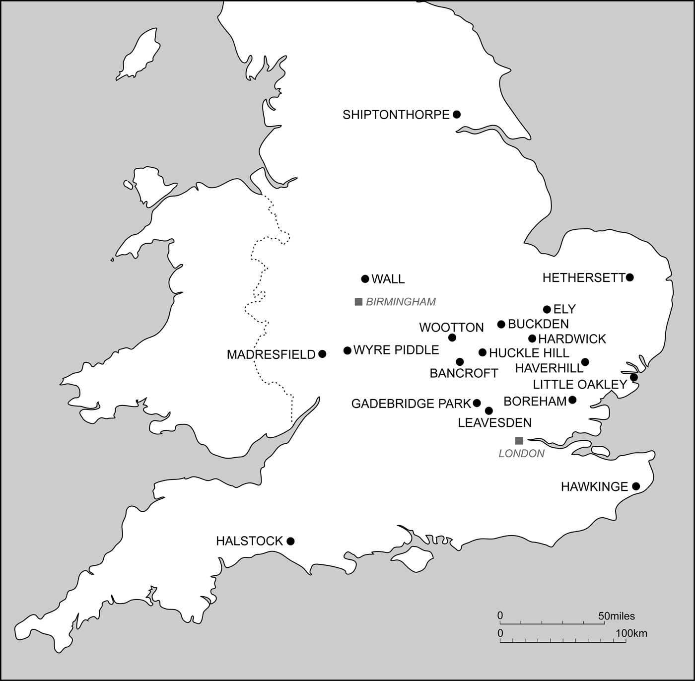
This article is particularly concerned with examples of Type (d). In relatively few cases is the identification of humanly constructed ponds clearly stated in the reporting of a site. In even fewer cases is function backed up with scientific investigation to establish firmer evidence for this identification (see fig. 7 for location of similar sites mentioned below).
Sites of Roman ponds mentioned in the text.

A good example of such a pond of similar size to that at Wyre Piddle is from Haverhill (Essex), which measures 21.5 by 18.4 m and 1.22 m deep and is described as an ‘irregular ovoid’.Footnote 60 Unlike in some other reports, the ‘pond’ here features prominently and is discussed carefully; in the process some familiar issues are raised, such as the difficulty of establishing a foundation date and the tendency for the fills of any intercutting features to disappear as they entered the pond. While there was some uncertainty as to whether it was partly natural, a deeper section in the centre suggested that it had at least been artificially deepened at this point to enhance its water storage capacity. The plentiful dating evidence here indicated construction in the mid-first century, with silting up taking place during the second century. There was no specific discussion of the character of the finds assemblage, suggesting that it was typical for that period. This description otherwise has many echoes with that of the Wyre Piddle pond, for instance the similar dating, quantity of finds and issues associated with excavation. Despite being unusual, the Haverhill pond was not that extensively explored, nor were the deposits checked for pollen. How far this was a result of the remains being unexpected, despite evaluation, is unclear, but typically resources could have been a problem with the discovery of such a large feature; even so its environmental potential had clearly been recognised and become a focus of the fieldwork.
At Ely (Cambs.) another pond was also of similar size, measuring 25 by 15 m. It was ovoid in plan and was associated with organically rich fills, though, in this case, mostly charred cereal waste.Footnote 61 This had been used in the mid-first to second centuries, and, while it was seen as eventually serving as a dumping ground for crop-processing waste, its original purpose was not debated and its fuller environmental potential (i.e. pollen) was not examined. Though this was again an evaluation exercise, the extent of any further and final investigations remains unspecified.
There are some examples where there has been careful and in-depth study of the deposits in a more research-orientated environment, as at Shiptonthorpe (Yorks.),Footnote 62 where a water-hole within a settlement was ramped on one side to provide easy access; while it produced insect evidence for the presence of dung, generally it had a suite of evidence more indicative of settlement than the surrounding landscape, due to its location. The fills also revealed signs of ritual deposition in the presence of complete pots early in its life and the patterns of animal remains incorporated both during use and after infilling. Here attention was particularly drawn to the animal skulls and cattle mandibles, with dog skulls being the most obviously placed items, though horse, cattle and dog skulls all occur around the edge of the feature.
Smaller examples have also been found. Thorough work at Buckden (Cambs.) demonstrated similar conclusions about the use of the pond and its environsFootnote 63 to that at Wyre Piddle. This smaller pond, dating to the first to third century, was 10 m in diameter and of a similar depth. An example at Hethersett (Cambs.), measuring c. 13 by 10 m, was trenched and subjected to environmental sampling. This produced evidence for a grassland setting and seasonally standing water in the first to third centuries;Footnote 64 in this case the site on clay was difficult to dig because of too dry conditions, again indicating the practical difficulties this type of site can present. Though reference was made to votive activity elsewhere on the site, no special attention was given to the finds from the pond, the latter being considered to be part of a farmyard with associated stock enclosures. Another similarly sized example from Huckle Hill (Beds.), measuring 13.6 by 10.8 m and 1.32 m deep, is also assigned a stock-watering function,Footnote 65 but without the corroborative evidence either to link it into the wider landscape or to support the interpretation offered.
In some cases, however, distinguishing artificial ponds has been problematic and excavators may instead have identified natural wet depressions (e.g. Hawkinge Aerodrome, Kent)Footnote 66 or a modified watercourse (e.g. Crane Brook, Wall, Staffs.).Footnote 67 In other cases distinguishing the type of pond has been difficult, as at Little Oakley (Essex), where a pond seemed too steep-sided for a stock pond and so was interpreted as a fish pond, especially given its villa setting, even though it was not in the typical position or constructed in the typical way for such a purpose.Footnote 68
The difficulty of even determining whether a pond was actually present at all has been regularly encountered, particularly in the course of evaluation work, where resources were probably insufficient to establish the full character of larger features, and especially where wet deposits have rendered the fieldwork difficult. At the Wyre Piddle site a second stage of prospective work, before excavation, was required to show the full extent of the pond. Other examples of this type come from Cambridgeshire (at Hardwick)Footnote 69 and Essex (at Generals Farm, Boreham).Footnote 70 From the available literature it is far from clear that where possible ponds were encountered during evaluation, they were the focus of further (i.e. subsequent) investigation, in order to resolve the uncertainties which these features tend to present or to realise their fuller potential. Their relatively large size compared with the more regular features and the difficult excavation conditions invariably associated with them, would often demand far greater resources than were originally available or anticipated. Therefore, they present a particular challenge on many fronts.
Meanwhile, purpose-built reservoirs, such as that at Nantwich for holding brine, can clearly be distinguished from ponds and are better classified as tanks; also, because of their industrial associations, they can more readily command archaeological attention and resources. Study of these could, however, still be useful, as their remains may still reflect practices which also applied to ponds. The great quantity and range of finds in the Nantwich tank fills, for instance, struck the excavators as likely evidence for structured deposition, while there was some sign of dismembered animal limbs, as at Wyre Piddle, as well as whole carcasses (calf, dogs). It may well be possible, therefore, to draw on the wider phenomenon of the purpose-built, usually industrial, reservoir-type features to help explain parts of the life-history of other specific types, such as agricultural ponds.
This is by no means an exhaustive survey of possible Roman ponds, as the distribution recorded in fig. 7 should not be seen as truly representative of the wider picture; indeed its apparent bias towards the East Midlands and East Anglia is more likely to reflect where organisations are more regularly reporting via OASIS and where HERs have more obviously classified the relevant evidence for it to be researched on Heritage Gateway — the two main sources used in this survey.
CONCLUSIONS
The humanly constructed Roman pond seems to be a relatively unusual feature, though it is clear that more ponds are likely to come to light with the routine evaluation of rural sites in the wake of development. Where identified, Roman ponds for stock watering do not vary that much in size and are generally found in close association with contemporary settlement rather than being set in isolation. Their principal purpose and use may be primarily inferred from their characteristic scale and profile and, where environmental (especially palynological) investigation has been carried out, confirmation of this likely role has been forthcoming (as at Wyre Piddle and Hethersett). At Wyre Piddle, the pond's location on higher ground and on a spring line could have met the practical need for a water supply for grazing animals, typically in spring/summer, though winter flooding on the flood-plain could have extended the grazing season on more elevated pasture, as long as efforts had been made to drain any excess water. These features can, therefore, be seen as a significant indicator of farming practice, by showing where pastoral farming had become firmly established. Other areas dominated by grassland have been recorded elsewhere across Roman Britain through palynology,Footnote 71 which helps to build up a picture of extensive livestock farming during the Roman period, as has been proposed by Grant.Footnote 72 Though this could not be readily assessed for the other Roman ponds mentioned above, the location of the Wyre Piddle pond also approximates to the pattern seen by Upex for later periods,Footnote 73 by being a likely location for a stock-watering pond, based on both geological criteria and distance from the nearest watercourse. This begins to provide some reassurance that the requirement for establishing Roman ponds was not much different from what applied later.
When such features went out of use, they sometimes seem to have attracted a significant quantity of finds. However, it is rare that such features are fully excavated and so it is not yet possible to make a detailed comparison with other sites for the results from Wyre Piddle. Here such material has been taken to represent a special event when the pond was finally silting up, possibly therefore representing its formal closure. Where dated, there is some indication that these features are more often early to mid-Roman, rather than still being open later in the Roman period, which raises questions about the changing nature of rural settlement and farming, with considerable agrarian change possibly occurring within the Roman period.
The Wyre Piddle pond, by virtue of its extensive excavation, has provided a large and unusual dataset towards the interpretation of this type of feature; its extensive environmental sampling has also contributed considerably to the interpretation of the wider landscape in the Roman period. Such features clearly have great archaeological potential, compared with other common features (such as ditches and pits), an importance which could usefully be recognised in the future. As new ponds are found, greater effort should perhaps be made to realise their full potential. This feature type might also be an appropriate subject for prospection (i.e. especially along spring lines) to ensure that such sites can then be appropriately managed in the interests of future research. Relatively newly available LiDAR data may be useful as a first stage, as silted-up ponds (and those just below the surface) may still be visible on LiDAR images.Footnote 74
ACKNOWLEDGEMENTS
The main specialist contributions were provided by Worcestershire Archive and Archaeology Service (WAAS) staff as follows: Laura Griffin (ceramics and other artefacts); Nicholas Daffern and Katie Head (pollen); Christine Elgy (chemical analysis); Andrew Mann (mollusca); Elizabeth Pearson (environmental archaeology); Sylvia Warman (animal bone); and Carolyn Hunt (illustrator). General assistance with the grey literature search was provided by Tim Cornah, Peter Lovett and Graham Arnold (WAAS). Numerous HERs, particularly for Cambridgeshire and Norfolk, are to be thanked for their prompt and informative response to enquiries. The helpful comments from the anonymous referees were much appreciated for providing further evidence in discriminating purpose-made water features of the period. The assistance of Severn Waste Services staff, especially John Harper (site foreman) and Ian Barber (director), and their support throughout the project are also gratefully acknowledged.
This paper is published with the aid of a grant from Historic England