Rapp and Hill (2006:1) provide a useful definition of geoarchaeology as “the application of any earth-science concept, technique, or knowledge base to the study of artifacts and the processes involved in the creation of the archaeological record.” Geoarchaeology is now recognized as a legitimate subfield of inquiry, with textbooks (Dincauze 2000; Goldberg and Macphail 2006; Rapp and Hill 2006; Waters 1992), the journal Geoarchaeology published since 1986, and advanced courses taught in many universities. The subfield includes topics such as the natural aspects of archaeological site formation and preservation, stratigraphy, sedimentation, erosion, reconstruction of ancient environments and climates, natural-cultural disasters and their aftermaths, resilience to unanticipated stresses, geochemistry, natural materials as resources, determining sources of materials in sites, ceramic and lithic petrography, dating, remote sensing, and geophysical exploration. Rapp and Hill (2006:273–275) are determinedly and exclusively scientific, but I argue here that avoiding the humanistic is unfortunate. I believe the more successful geoarchaeological research projects in Mesoamerica are those that do not stop at academic boundaries, but rather seek relevant data and insights from the full range of physical sciences, social sciences, and the humanities. Even the hallowed journal Science recently reported the beginnings of multidisciplinary research in geophysical disasters that highlight mythology, oral history and religion of native peoples, in addition to scientific geophysical and geoarchaeological components (Krajic 2005). And volcanologists in Costa Rica, at the southernmost end of Mesoamerica, are beginning to explore how eruptions may have affected ancient peoples and become preserved in legend (Alvarado and Soto 2008). Significant human events, be they crises or successes, rarely occur within the tight boundaries of a traditional Western scholarly subfield.
EARLY STUDIES
Geology as a discipline developed about a century before archaeology, and archaeologists in the late nineteenth and early twentieth centuries adopted geological concepts such as type fossils (archaeologists' “diagnostic” artifacts), uniformitarianism, stratigraphy, and relative dating. They were also aware of context, as nineteenth-century European scholars found handaxes in ice-age gravels associated with extinct megafauna, finally followed by somewhat similar discoveries at Paleoindian sites in the American Southwest and in Mesoamerica. Early archaeologists were not shy about borrowing theory and methods from geology, and thus it would be difficult to find a significant Mesoamerican research project conducted during recent decades that did not incorporate some aspects of geology.
During the second half of the twentieth century Mesoamerican archaeologists were increasingly exploiting geological techniques such as quantitative dating, petrography, and instrumentation to determine sources of materials such as obsidian and jade and methods to reconstruct past environments (Rapp and Hill 2006; Waters 1992). They were gaining sophistication in understanding modes of emplacement of various natural and anthropogenic sediments and the numerous natural processes that affect sites after abandonment.
THE PRESENT KATUN : 1990–2009
The katun to which I am referring is not an actual Maya katun but, rather, the completion and celebration of a katun-length period of 20 years of publication of the journal Ancient Mesoamerica. This article is organized geographically from northwest to southeast. Space limitations obviate comprehensive coverage. Rather, topics and examples must suffice.
West Mexico
Some of the best geoarchaeological research in west Mexico focuses on Lake Patzcuaro (Bischoff et al. 2004). Issues include episodes of erosion evidently caused by ancient agriculture (O'Hara et al. 1993; Street-Perrott et al. 1989; but challenged by Fisher 2005). Pollard and Gorenstein (1980) suggest the ancient Tarascans living in the Patzcuaro Basin were not agriculturally self-sufficient and had to rely on imports such as maize. Fowler, McCafferty, and Hirshman (2008) introduce a special section of Ancient Mesoamerica devoted to Tarascan issues—including soils, agricultural productivity, carrying capacities, and paleodemography—in increasingly sophisticated economic, political, and humanistic contexts.
Opportunities abound for integrated future research. For instance, Sieron and Siebe (2008) have dated a large explosive eruption of Ceboruco volcano in Nayarit to about a.d. 1000. It covered over 560 km2 with more than 50 cm of tephra (airfall volcanic ash, cinders, and pumice), and I suspect it buried over one hundred Early Postclassic period villages and towns. Regional survey, testing, and geophysical exploration could encounter exceptionally well-preserved sites that could provide unusually clear windows into west Mexican indigenous life of commoners and elites in the Early Postclassic period.
Central Mexico
Plunket and Uruñuela (1998a) provide a central Mexican example of what could be achieved by west Mexican research under the Ceboruco tephra. They have conducted multidisciplinary geoarchaeology in Puebla, on the eastern slopes of the Popocatepetl volcano since 1993. They documented volcano deity worship from Late Formative times through the Classic period, Spanish Colonial times, and up to the present when the deity is named “Gregorio” (Plunket and Uruñuela 1998b). The ancient residents' perceptions of risk over two millennia certainly have been justified, given two great eruptions and numerous smaller ones. I suggest some of the displaced émigrés from the earlier eruption, about 2,000 years ago, ended up as slaves to the nascent elite at Teotihuacan, convenient for their burgeoning program of monumental construction. Isotopic analyses of possible immigrants at Teotihuacan could test this suggestion. Uruñuela and Plunket's research (2007) is broad-range, encompassing natural science, social science, and humanistic concerns.
An overview of central Mexican volcanism and ancient societies is available elsewhere (Sheets 1999). An important natural product of volcanism is obsidian, geoarchaeologically characterized at Pachuca (Ponomarenko 2004) and elsewhere in Mesoamerica, as well as north of Mesoamerica (see Shackley 1998), and as far southeast as the small sources in Honduras (Aoyama et al. 1999). The literature on sourcing obsidian is of utmost importance, but it is too vast to be included here. Dozens of Mesoamerican sites, from highland Mexico to the southeast periphery, have had their obsidian artifacts analyzed qualitatively and quantitatively, to identify the natural source. More recently some archaeologists have trained themselves to visually identify the sources of artifactual obsidian with a high degree of accuracy (Braswell et al. 2000).
Manzanilla and colleagues have conducted similarly broad-range research, including sophisticated geoarchaeology at Teotihuacan throughout the katun (Barba et al. 2007). They pioneered the use of geochemical analyses of lime-plastered floors to detect human activities at Teotihuacan and other sites, including an ethnoarchaeological case in Tlaxcala that generated known chemical signatures from documented activities of cooking, eating, and storage (Barba and Ortiz 1992).
Perhaps the most sophisticated current project in Mesoamerica to integrate geoarchaeology with the full range of social- and natural-scientific research with the humanities is that directed by Art Joyce (1991) in Oaxaca, spanning the full katun, and boding well for the upcoming one. Working regionally, Joyce and Mueller (1992, 1997) and Gorman et al. (2005) documented accelerated soil erosion in the Oaxacan highlands (Monte Albán and environs) during the Formative period and emplacement of those sediments in the lower Verde Valley near the Pacific Ocean. For centuries prior to 500 b.c. highland sediments were deposited in an open bay, but about that time the sediment load increased sufficiently to create a barrier and estuary environment. People apparently took advantage of the marked increase in life support capacity of the lower floodplain and lagoon-estuary environments, and population densities increased significantly. However, localized flooding also increased, creating difficulties for people living in the lower floodplain (Joyce and Mueller 1997). Such geoarchaeology is integrated with the social science aspects of the project such as paleodemography, politics, economics, and with humanistic aspects such as post-structural theory. The latter is exemplified by Joyce and Weller's (2007) consideration of commoner resistance to elite authority and agency involved with the founding of Monte Albán (Joyce 2000). Barber and Joyce (2007) explore how lower Verde people negotiated social status and political authority in the domain of practice theory, primarily by means of interred caches and monumental construction. Joyce is presently extracting sediment cores from ponds and estuaries to study past environments, and Barber is exploring the monumental center of Rio Viejo with ground-penetrating radar. The integration of geoarchaeology into the full range of scholarship, within a regional research design in Joyce's project, provides a stimulating example for researchers in the next katun.
The Huasteca anchors a northern corner of Mesoamerica, where Hudson (2004) documented the floodplain dynamics of the lower Panuco and Moctezuma Rivers and how those dynamics affected human settlement. Sustained multidisciplinary research inspired by Joyce's research program in Oaxaca could yield compelling understandings of human-environmental relationships in the past three or four millennia to the present day.
The Olmec lowlands and the Isthmus of Tehuantepec
Much of Santley's lifework (2007) was devoted to understanding ancient peoples in the Tuxtla Mountains of Mexico's southern Gulf Coast. He documented the impacts and recoveries of people from six explosive eruptions in the Tuxtla Volcanic Field, from approximately 2500 b.c. to the most recent at about a.d. 600. Santley believed more complex societies were more resilient to natural disasters than simpler societies (but see Sheets 2008). Gorman and Byrne (1998) documented forest cutting for agriculture in the Tuxtlas beginning about 3000 b.c., based on lake cores. The agriculture intensified in the Preclassic to Middle Classic periods. After each episode of agriculture, the forest required about three centuries to regenerate. Just southeast of the Tuxtlas is the major Olmec site of San Lorenzo Tenochtitlan, where Coe and Diehl (1980) conducted intensive archaeological and environmental research in an earlier katun. Still farther south, across the Isthmus of Tehuantepec, is where Voorhies (2004) explored the natural environment in the Chantuto area using geoarchaeology to understand adaptations during the Archaic period (5500–1500 b.c.). A semi-sedentary lifestyle developed early and reached stability in a way strikingly similar to that at Cerro Mangote in Panama (Willey 1971:263). Those two sites are examples of what must have happened dozens of times in estuaries along all Mesoamerican coasts as people learned to exploit the resources, including mangrove oysters, fish, and shrimp, of these richly productive but isolated environments.
The Maya realm
Virtually every type of natural disaster known on earth has been used to try to explain the Classic Maya collapse, including earthquakes, hurricanes, volcanism, drought, soil degradation, disease, grass competition with cultigens, and pestilence. And, of course, scholars have proposed a robust variety of cultural/anthropogenic factors including invasion, peasant revolution, religious failure, and internecine warfare (Culbert 1973). Few geoarchaeological causes have stood the test of time and evidence. However, in lake cores in the Maya Lowlands Brenner et al. (2001, 2002) have found compelling evidence of drought from a.d. 800–1000. I believe drought may have accelerated the collapse of the Southern Maya Lowlands, but the Maya in the area had crossed the threshold of sustainability a few centuries earlier and were insuring their crisis of adaptation through overpopulation, environmental degradation, and resultant societal stresses that included malnutrition and warfare. Common difficulties that scholars encounter who are promoting a single geophysical cause of the collapse are that they do not consider the interplay of social factors and cultural adjustments to external stresses. For instance, drought does not invariably lead to collapse.
A range of geoarchaeological-ecological topics interested Maya researchers during the katun. Wetlands and water management continue to be controversial issues (Dunning et al. 1998, 2002; Lucero 2002; Sluyter 1994). Gunn et al. (2002) trace climate changes over the past 4,000 years, and find correlations with the time breaks that begin and end periods, thus indicating the effects of natural factors on ancient peoples. Masson (1995) argued that stratigraphic factors led to underestimates of Postclassic period populations in Belize, and the collapse there was not as severe as many had thought. Postclassic period deposits are generally on the surface and are thus greatly affected by the elements post-abandonment with few chances for radiocarbon dating from sealed contexts and thus are under-recognized (Masson, personal communication 2008).
Inspired by successes in central Mexico, the detailed analyses of soil chemistry and chemical residues in floors have developed dramatically during the katun (Fernández et al. 2002; Jensen et al. 2007; Johnson et al. 2007; Parnell et al. 2001; Terry et al. 2000; and Webb et al. 2007). For instance, at the site of Joya de Cerén, Parnell et al. (2002) discovered high phosphate concentrations just south of the wall of the community ritual/feasting structure. The wastage from processing deer within the building apparently was tossed over the wall in provisional discard and left its chemical signature on the outside floor.
Isotopic study of human remains is an important development during the katun, especially compelling when combined with osteology. Buikstra et al. (2004) provide an excellent example from Copan. The injuries sustained in battle or on the ballcourt by the founding king K'inich Yax K'uk' Mo' would have been exceedingly painful day and night. Strontium and oxygen isotopes indicate he grew up in the central Peten and moved to Copan as a young adult. This evidence contradicts interpretations based upon artistic and epigraphic sources. An inspiration for scholars interested in isotopic signatures of an individual's past loci of residence is provided by the analyses of Ötzi, the “Alpine iceman” who lived in what is now northern Italy over 5,000 years ago (Mueller et al. 2003). The future of isotopic studies in Mesoamerica is a bright one, especially when combined with and contrasted to other data sets.
Dull (2007) analyzed sediments from Laguna Cuzcachapa, in Chalchuapa, El Salvador, for pollen, charcoal, magnetic susceptibility, and sediment influx. He found clear evidence of intensive maize cultivation by 1700 b.c. His research on the cataclysmic Tierra Blanca Joven (TBJ) eruption (Dull 2007; Dull et al. 2001) deserves greater attention by archeologists for its effects on demography, culture, religion, and legend. That eruption was the greatest in Central America in the past 84,000 years, and its demographic, ecologic, societal, and humanistic impacts have only begun to be understood.
Volcanism has been studied in the Maya Highlands (Sheets 1999, 2007) with the pattern emerging that most societies were resilient to the sudden massive stresses of unanticipated eruptions (Sheets 2004). Only the greatest of eruptions exceeded the local people's abilities to cope and had effects that lasted for centuries, such as the Ilopango eruption in El Salvador (Dull et al. 2001). Geophysical instrumentation, including magnetometers, seismographs, electromagnetic induction, resistivity, and ground-penetrating radar have been used to explore occupied surfaces below the Ilopango tephra and particularly below later tephra deposits (Conyers 1995; Sheets 2002). The latter two instrument systems have been successful in detecting buildings as anomalies, and imaging the Classic period ground surface in patios, a plaza, and agricultural fields.
The study of caves in the Maya area provides an excellent example of research that has matured into the full spectrum of humanistic-to-scientific approaches during this katun (Brady 1997). Caves and their speleothems are studied geoarchaeologically (Brady, Scott, Neff, and Glascock 1997) and as portals into the supernatural domain in terms of origins (Nielsen and Brady 2006) and their economic and political implications as exemplified by Stone Houses and Earth Lords: Maya Religion in the Cave Context (Prufer and Brady 2005). Prufer and Brady compellingly show how the Maya viewed caves as mouths of the underworld deity, with stalactites representing fangs, and the air moving in and out of the caves being the breathing of the deity. Because atmospheric pressure oscillates so much on a daily-to-weekly basis, it is understandable why the Maya believed the cave was breathing. An atmospheric high causes inhalation by pushing air into the cave, and a low causes exhalation. A cave with greater internal volume breathes more exuberantly and thus forms an integral part of the Maya understanding of the world as animate, and the elements such as caves with agency.
The nature and breadth of research at Copan in the past two decades is exemplary. Two recent volumes on Copan (Andrews and Fash 2005; Bell et al. 2004) illustrate the role that geoarchaeological studies can play in understanding aspects of the emergence, functioning, and demise of this southeasternmost Maya polity. Those studies include resources and their exploitation (Davis-Salazar 2006), isotopes, and soils. It appears that Copan crossed the threshold of ecological sustainability early in the sixth century (Webster et al. 2000). Yet population continued to increase, concomitant with nutritional problems, deforestation, and soil erosion, all reaching a peak by the mid-eighth century. Thus, an ecologist could extol the successes of the Copan Maya in the fifth century. But a humanist would note the apex of artistic-architectural-epigraphic developments much later, in the eighth century. Tikal may have followed a similar trajectory, with the apex of cultural development occurring in the late seventh to early eighth centuries (Harrison 1999) but the threshold of sustainability having been crossed much earlier. I am hopeful that geoarchaeology can continue to contribute to future studies incorporating ecology and sustainability with social science and the humanities to investigate the interplay of factors in the great trajectory of ancient Maya civilization.
The Intermediate Area
Geoarchaeological research has been spotty here compared to Mesoamerica. For instance, the fascinating sets of human and animal footprints at Acahualinca in Managua, Nicaragua, have been studied informally by many with claims of dates to Paleoindian and virtually all other pre-Columbian periods. The discoverer suggested they could date to 200,000 years ago (Flint 1884), and some argued that because there were so many prints people must have been living in cities of 30,000 or more. Fortunately Hans-Ulrich Schmincke (personal communication 2007) has done the first sophisticated geoarchaeology of the prints and their context, and dated them to about 100 b.c. He interprets them as one group of about six people and two smaller groups on either side, for a total of about 15. Both genders and all ages were walking rapidly toward the shore of Lake Managua. They probably were escaping from an eruption of the Masaya Volcano.
Lange et al. (1992) published the results of their survey and testing program along the western margin of Nicaragua, which included geochemical analyses of obsidian and ceramic artifacts along with suggestions on cultural patterns and variations as well as external relationships with Mesoamerica and Lower Central America.
Evans (2008a:182–184) provides an overview of southeastern Mesoamerica past the Maya, an ethnically and linguistically complex zone to some degree affected by the Maya but in many cases resistant to Maya culture. Douglass (2002) reports on how commoner agrarian households in northwest Honduras achieved a high degree of economic self-sufficiency by relying on local natural resources during the Classic period. The earliest Mesoamerican influences date back to Olmec times in the mid-Formative period in the western portion of Honduras (Evans 2008a:183). And some Olmec jades have been found in Costa Rica, mostly by illicit excavations, but I believe they were sent south by Classic period Maya along with large amounts of Maya jades in exchange for quetzal feathers from the high cloud forest. Thus, Olmec artifacts in Costa Rica do not signify Olmec trading relations with native Costa Ricans.
The Southern Periphery: Costa Rica
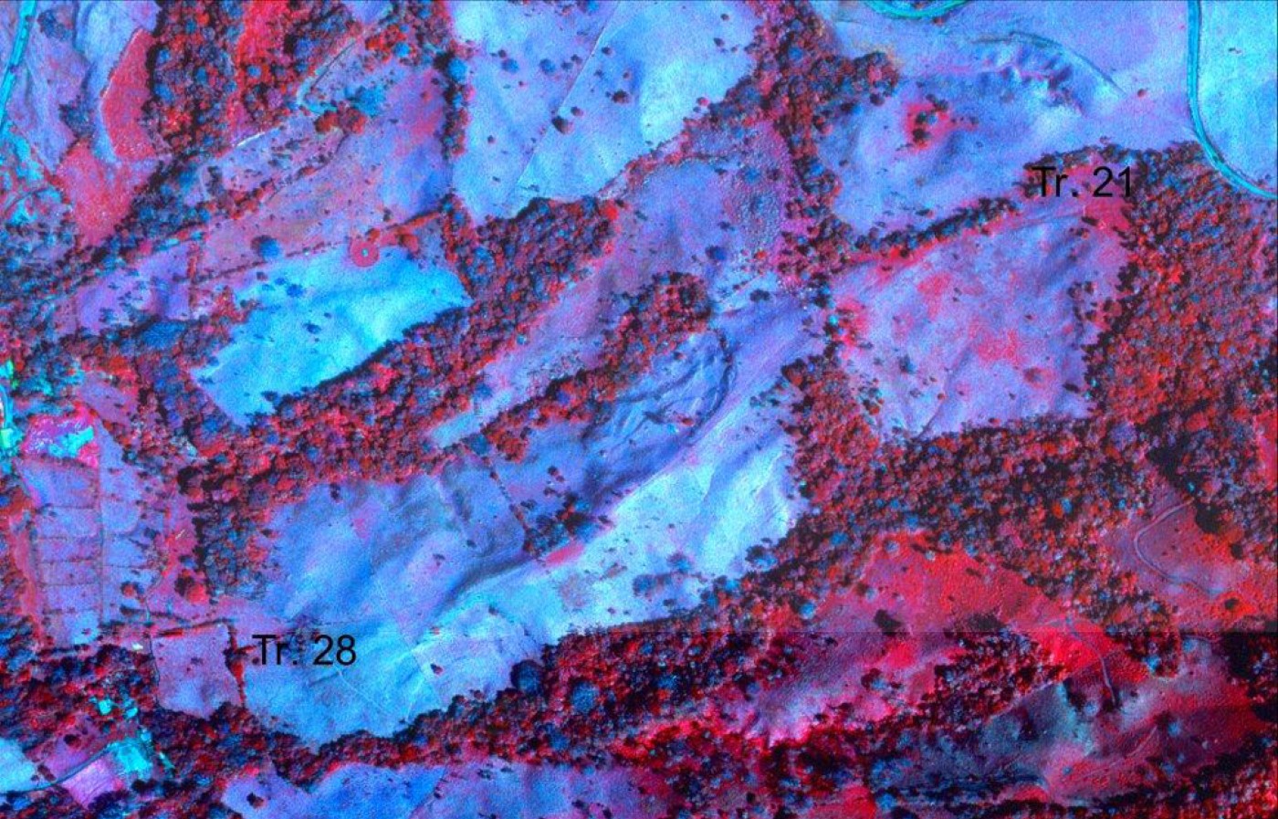
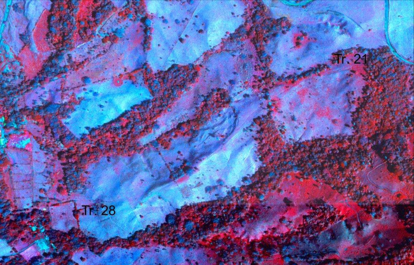
Willey (1966:85), following Kirchhoff (1943), extended the southern boundary of Mesoamerica all the way down into Central America to include northwestern Costa Rica. Thus the Arenal area could be considered barely within Mesoamerica. The Arenal project was designed to incorporate the most sophisticated remote sensing that NASA could provide (Sheets and Sever 2006), along with detailed volcanology, in a regional research design (Sheets and McKee 1994). The most dramatic culture change in the 10,000 years of occupation was a religious change or conversion that occurred at about 500 b.c., when people separated their cemetery from their village and began walking the same exact single-file processional path between them (Figure 1) (Sheets and McKee 1994). The greatest environmental change occurred at about that same time, from dryer to wetter conditions, based on paleolimnological evidence (Arford 2000). It is unknown if the cultural and environmental changes were related. Villages regularly were recolonized following explosive eruptions of Arenal volcano after ecological recovery had occurred, which probably required a decade, or few decades. Using all the analytical tools at our disposal we were unable to answer the question “were the reoccupants the descendants of the original villagers before the eruption, or were they unrelated people simply taking advantage of a habitable location?” The decidedly humanistic direction of the project recently has provided the beginnings of an answer, as we realized people recolonized their villages in order to reestablish long-distance paths to their cemeteries to reconnect with the spirits of their deceased ancestors (Sheets and Sever 2007). Because the path was buried by a volcanic ash layer and was barely visible, it would be difficult for someone reoccupying the village to follow that path. And if the people reoccupying the village were unrelated to those who lived there before the eruption, they would have had no reason to begin using an obscure path to someone else's cemetery. We believe this is strong evidence of direct descent, and we are thinking that refugees even may have returned to the locus of the village to perform single-file pilgrimages to their cemetery and rituals there before they reestablished the village itself. In retrospect we recognize the importance of ecological-volcanological research and remote sensing to create the foundations on which we can explore religious/humanistic interpretations of past belief and practice. We believe all elements are of great importance to understanding what people did in the ancient past.
IKONOS satellite image of Arenal-Tilaran area in northwestern Costa Rica, emphasizing color infrared. The Arenal phase ancient footpath is the faint darker line running from Trench 21 in the upper right, downhill to Trench 28 in the lower left. The village is 10 km farther west of Trench 21 and the cemetery is 2 km to the east of Trench 28.
CONCLUSIONS
In this brief overview of geoarchaeology in Mesoamerica during this expiring katun, two research projects are identified that are not artificially circumscribed by Western disciplinary boundaries. One is the research in Oaxaca directed by Joyce (1991, 2000) and the other on caves conducted by Brady (1997) and associates. Both projects overtly include a full range of human and natural phenomena. Their setting a high and broad-range standard bodes well for the next katun. With more space, other examples could have been developed in this article, such as broad-range projects within which geochemical studies of residues and isotopic studies of human remains could support or challenge interpretations based on epigraphy, iconography, art, or other aspects of culture.
The most common theoretical orientation to geoarchaeological research conducted in Mesoamerica during the expiring katun has been processual, viewing societies as integrated systems. Thus, a responsibility of the elite was to keep societies functioning within their environments as they controlled adaptations, economics, politics, and religious belief and practice. Such a “top-down” view of societies in their environments, with elites in control, presents a crisp and clear view of human-cultural-environmental relationships. But it may be far from the whole story. During this katun a small but growing group of scholars has reversed the directionality and has explored societal functioning from the “bottom-up” as commoners develop, experiment with, or enhance their adaptations, beliefs, and practices. Commoners can resist decisions or pressures from the elite by quiet or, occasionally, overt means. Commoners have agency in the sense that they can make decisions that affect their lives and the lives of others at various levels of a society. I suspect many aspects of elite practice developed from, and were elaborated upon, practice of commoners. Scholars exploring this new approach often use practice theory, agency, and resistance. Commoners, as well as others at any locus in a social system, can either sustain or modify their society. Thus there are no people who are powerless automatons acting as gears in the machine of society. I look forward to the dawning katun with theoretical diversity more compellingly representing the full range of ancient societal functioning and with geoarchaeology being a contributing component to many research projects. It is my hope that isolated/defensive geoarchaeology is a thing of the past.
RESUMEN
La geoarqueología se ha definido como "la aplicación de cualquier concepto, técnica o base de conocimiento de geología al estudio de los artefactos y los procesos involucrados en la creación del registro arqueológico” (Rapp y Hill 2006:1). La geoarqueología incluye temas como los aspectos naturales de la formación de sitios arqueológicos y su preservación, la estratigrafía, la sedimentación, la erosión, la reconstrucción de ambientes antiguos y climas, los desastres naturales-culturales y sus consecuencias, la geoquímica, los materiales naturales como los recursos, la determinación de fuentes de materiales en los sitios, el fechamiento, la prospección remota y la exploración geofísica. Este estudio de la literatura geofísica en el katun que empezó en 1990 y está terminando este año muestra una amplia gama de proyectos, desde los que usan sólo un aspecto particular de la geoarquelogía, hasta los que emplean muchos aspectos distintos. Hay también un rango llamativo de proyectos y estudios, de aquellos que sólo hacen la geoarqueología con una orientación científica, hasta los que emplean la geoarqueología dentro de un marco más amplio. Dos programas de la investigación ejemplifican la última aproximación.
Un proyecto destacado aquí está dirigido por Arthur Joyce (1991, 2000) en Oaxaca. Joyce y sus colegas han documentado la erosión en las montañas de Oaxaca durante el período preclásico, probablemente causado por la intensificación de agricultura y la deposición de sedimentos en el valle bajo del río Verde. Desde hace aproximadamente 2500 años los sedimentos acumulados crearon una barrera y una albufera, resultando en un aumento en la capacidad de apoyo de vida del medio ambiente. Los aumentos demográficos, junto con el desarrollo de sociedades más complejas y los intercambios de larga distancia en el bajo Verde estaban claramente relacionados a estos cambios geofísicos. Además, el proyecto está investigando la capacidad de fenómenos naturales y culturales de penetrar profundamente en los aspectos humanísticos de la vida considerando, desde la perspectiva de la teoría de la práctica, como las personas negociaban el estado social y la autoridad política. Así que, se emplea la teoría post-estructural para ayudar a entender que personas de todos niveles de sociedad y autoridad participaron en la Oaxaca antigua.
El otro proyecto destacado es el estudio de extensión amplia de cuevas mayas llevado a cabo por James Brady (1997). Brady y sus colegas estudian las cuevas como fenómenos naturales con sus espeleotemas, y los relacionan a la arquitectura y las viviendas. También consideran la cosmología y como se puede entender los rituales por medio del estudio de las cuevas y sus contenidos. Las interpretaciones de simbolismo de las cuevas en el arte, particularmente en los vasos cerámicos pintados y en los murales, nos informan sobre las creencias de los mayas.
Durante el katun de 1990 al presente, ha habido un aumento general en la sofisticación de arqueólogos que usan la geoarqueología para ayudar a resolver problemas analíticos y formular preguntas para investigar. Además, algunos proyectos han integrado la geoarqueología dentro de un plan de investigación de extensión amplia que aprovecha una amplia gama de conocimientos, de las ciencias naturales y las ciencias sociales y también incluyendo perspectivas de las humanidades. Estas tendencias presagian buenos resultados para los estudios geoarqueológicos en el próximo katun de investigación en Mesoamérica.
ACKNOWLEDGEMENTS
I appreciate the invitation by Geoffrey McCafferty, Bill Fowler, and the Ancient Mesoamerica editorial board to write this article on geoarchaeology in Mesoamerica. I thank Adam Blanford for references for West Mexico. I heartily thank my Colorado colleagues for their careful and thorough critiques of an earlier draft. Cathy Cameron, Art Joyce, and Beth Dusinberre were particularly helpful. I thank Hans-Ulrich Schmincke for sharing with me the results of his recent research on the human and animal footprints in the tephra in Pacific Nicaragua.