INTRODUCTION
Archaeological earthen mounds in South America have been analyzed under different perspectives and for variable purposes (Bracco et al. Reference Bracco, Cabrera and López2000, Reference Bracco, del Puerto and Inda2008; Gianotti Reference Gianotti2000; Lopez Mazz 2001; Boado et al. Reference Boado, Gianotti and Borrazás2006; Iriarte Reference Iriarte2006; Bonomo et al. Reference Bonomo, Politis and Gianotti2011; Gianotti García Reference Gianotti2015). Known as aterros in Portuguese, and cerritos in Spanish, these sites have been mapped along the lowlands of the Pampas biome and La Plata Basin in Brazil, Uruguay, and Argentina (Figure 1). Cerritos are usually interpreted as constructions made by complex ancient societies with a mixed economy that includes fishing and hunting medium and small mammals, as well as the handling of some plants such as corn (Zea mays), pumpkin (Cucurbitaceae sp.), peanuts (Arachis hypogaea), and medicinal and narcotic herbs (Iriarte Reference Iriarte2006; Bracco et al. Reference Bracco, del Puerto and Inda2008; Lopez Mazz and Bracco Reference Lopez Mazz and Bracco2010; Bonomo et al. Reference Bonomo, Politis and Gianotti2011). These settlements date from around 5000 cal BP to 200 cal BP (Schmitz Reference Schmitz1976; Iriarte Reference Iriarte2006; Bracco et al. Reference Bracco, del Puerto and Inda2008), constituting a phenomenon from the mid-Holocene to the colonial period with more than 1500 mounds registered (Bracco et al. Reference Bracco, Cabrera and López2000, Reference Bracco, del Puerto and Inda2008; Gianotti Reference Gianotti2000, Reference Gianotti2015; Boado et al. Reference Boado, Gianotti and Borrazás2006; Iriarte Reference Iriarte2006; Lopez Mazz and Bracco Reference Lopez Mazz and Bracco2010; Bonomo et al. Reference Bonomo, Politis and Gianotti2011).
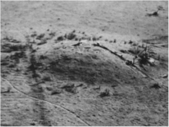
Cerrito of San Luís, Uruguay. Modified from Lopez Mazz (Reference Lopez Mazz2001).

In the 1970s, these earthen mounds were thought as non-intentional fishing camps, passively raised because of the seasonal occupation year after year. The people would spend the hot periods, during fishing season, above the swamps at the shore of the Patos Lagoon, as an evolutionary adaptation to aquatic environments (known as the classic model by Schmitz Reference Schmitz1976). However, from the 1990s onward, this simplistic view has been revised with new archaeological data showing a relationship between these mounds and burial practices, as well as adjacent areas used for living, agriculture, and waste disposal (Iriarte Reference Iriarte2006; Bracco et al. Reference Bracco, del Puerto and Inda2008). Topographical transformations including micro-reliefs (mounds with less than 30 cm high), elongated platforms, borrow pits, tracks, pathways, and artificial lakes have been registered around the mounds and linked the occupational sites to the surrounding environments, suggesting a systematic long-term landscape management (Villagran and Gianotti 2013). Currently, the archaeological perception of the mounds is that they are part of a complex engineering system involving monumentality, landscape transformation and territory aggregation (Bracco et al. Reference Bracco, del Puerto and Inda2008; Bonomo et al. Reference Bonomo, Politis and Gianotti2011; Villagran and Gianotti 2013).
To study the environmental aspects of such complex settlements, it is crucial to understand their chronology and evaluate the synchronicity of their occupation. As chronological records, archaeological remains such as charcoal, fish otolith and bones are the options for radiocarbon (14C) dating. Among those, fish otoliths are the most abundant in such context and, therefore, a nice option for acquiring a more statistically robust set of results. However, when dealing with coastal samples it is crucial to take into account both the marine reservoir effect (MRE) and the freshwater reservoir effect (FRE).
Background on Marine and Freshwater Reservoir Corrections
The MRE arises from the fact that the carbon cycle in the ocean is quite different from the terrestrial one. Indeed, the MRE is related to the incorporation and distribution of 14C in the marine environment, being dependent on factors such as the air–sea gas exchange and the ocean dynamics (Stuiver and Braziunas Reference Stuiver and Braziunas1993). These factors alongside other geographical and climate conditions lead to an offset in 14C age between global ocean surface waters and atmosphere, the so-called R(t) (Stuiver et al. Reference Stuiver, Gordon and Braziunas1986). R(t) is a time-varying value that reflects shifts in atmospheric 14C, albeit a more damped response due to ocean circulation. Even though there is an available average value for this offset (405±22 14C yr in the Northern Hemisphere [Hughen et al. Reference Hughen, Baillie, Bard, Beck, Bertrand, Blackwell, Buck, Burr, Cutler, Damon, Edwards, Fairbanks, Friedrich, Guilderson, Kromer, McCormac, Manning, Ramsey, Reimer, Reimer, Remmele, Southon, Stuiver, Talamo, Taylor, van der Plicht and Weyhenmeyer2004]), deviations from the marine calibration curve (the most recent being the Marine13 [Reimer et al. Reference Reimer, Bard, Bayliss, Beck, Blackwell, Bronk Ramsey, Grootes, Guilderson, Haflidason, Hajdas, Hatté, Heaton, Hoffmann, Hogg, Hughen, Kaiser, Kromer, Manning, Niu, Reimer, Richards, Scott, Southon, Staff, Turney and van der Plicht2013]), known as ∆R values, present large geographical variability and can be remarkably significant for the accurate calibration of marine ages (Ascough et al. Reference Ascough, Cook, Church, Dugmore, Arge and McGovern2006). Stuiver et al. (Reference Stuiver, Gordon and Braziunas1986) introduced the concept of ∆R as being the difference in reservoir age between the regional (from where the marine sample is derived) and their modeled ocean (represented by the marine calibration curve). For this reason, whenever 14C measurements are performed in marine influenced material, a relevant ∆R should be considered when correcting for MRE. On the other hand, systems such as lakes or rivers may be better described as freshwater reservoirs, influenced by groundwater input of dissolved inorganic carbon (DIC), restriction of atmosphere-water CO2 exchange or derived from terrestrial catchment, leading to a FRE (Ascough et al. Reference Ascough, Cook, Church, Dunbar, Einarsson, McGovern, Dugmore, Perdikaris, Hastie, Friðriksson and Gestsdóttir2010; Keaveney and Reimer Reference Keaveney and Reimer2012; Keaveney et al. Reference Keaveney, Reimer and Foy2015a, Reference Keaveney, Reimer and Foy2015b). Catchment changes or flood events may lead to the export of terrestrial carbon derived from material of different ages. Terrestrial carbon can be derived from photosynthetic material, deposited right after death, hence contemporary with the coeval atmosphere, lowering R values in these regions. On the other hand, subsurface carbon previously sequestered in soil/peat stocks can be decades to centuries older than atmosphere (Trumbore Reference Trumbore2000; Douglas et al. Reference Douglas, Pagani, Eglinton, Brenner, Hodell, Curtis, Ma and Breckenridge2014; Keaveney et al. Reference Keaveney, Reimer and Foy2015a, Reference Keaveney, Reimer and Foy2015b). The presence of old carbonate sources in the surrounding geology (e.g. limestone strata), will also increase R values in freshwater systems (Broecker and Walton Reference Broecker and Walton1959). Olsen et al. (Reference Olsen, Heinemejer, Lübcke, Lüth and Terberger2010) observed apparent ages of up to 800 14C yr when studying dietary habits and freshwater effects through 13C/12C and 14C dating analyses of animal and human bones from a German cemetery. Keaveney and Reimer (Reference Keaveney and Reimer2012) have surveyed samples from lakes and rivers in different geological settings in Britain and Ireland to study variability in FRE, obtaining a maximum offset of 1638 14C yr.
In environments, such as estuaries and lagoons, the situation is even more complex, since carbon from either modern or ancient carbonate sources or terrestrial plant detritus can be introduced by rivers and this has the effect of changing what would be MRE values, already influenced by ocean dynamics (Keith et al. Reference Keith, Anderson and Eichler1964; Schell Reference Schell1983; Fry and Sherr Reference Fry and Sherr1984; Tanaka et al. Reference Tanaka, Monaghan and Rye1986; Krantz et al. Reference Krantz, Williams and Jones1987). Estuaries and lagoons are, therefore, environments where reservoir corrections can vary from atmospheric values to highly depleted 14C concentrations. Several examples can be found in literature where coastal systems are both influenced by marine and continental carbon sources. Keith et al. (Reference Keith, Anderson and Eichler1964) have conducted a systematic survey exploring the isotopic composition of mollusk shells from different environments. Although their results showed that freshwater shells were 13C and 18O depleted in comparison to their marine counterparts, differences within subgroups could not be neglected. Offsets in 13C composition among freshwater species were attributed to the environment (e.g. lakes and rivers) and the authors concluded that mollusk shells exhibit a carbon isotopic ratio strongly controlled by their diet and humus decay in the water.
The environment control on the isotopic composition of shells is also supported by the work of Schell (Reference Schell1983) in an estuarine region in Alaska. His analyses of 13C and 14C compositions of a wide range of organisms demonstrate that the absorption of terrestrial carbon by high trophic levels is larger in freshwater environments than it is in the ocean. According to the author, this phenomenon would be due to the abundant presence of organisms which are dependent on peat at the bottom of freshwater reservoir’s food chains. In 1986, Tanaka and colleagues measured the ratios 14C/12C and 13C/12C of sea water, shell and meat of barnacles and mollusks collected alive in three different sites in Connecticut. They also analyzed sediments and seaweed from one of the sites and phytoplankton from another. Based on the results obtained, the authors conclude that ~50% of the carbonate present in the shells are derived from metabolic carbon. Thus, metabolic terrestrial organic matter incorporated by organisms in near shore environments is likely to be present in the shells of these animals. Krantz et al. (Reference Krantz, Williams and Jones1987) analyzed both 18O and 13C contents of two species of mollusks collected off the Virginia coast. The carbon results reinforced the idea of environmental influences on the shell composition since seasonal trends associated to phytoplankton productivity were observed in both species. Moreover, epifaunal/infaunal carbon offsets were also present.
Little (Reference Little1993) analyzed shells from coastal Massachusetts and argued that transient events introduced modern terrestrial material into tidal marshes, which explains the low ∆R value observed (∆R=–200±135 14C yr).
Zoppi et al. (Reference Zoppi, Albani, Ammerman, Hua, Lawson and Barbero2001) calculated a reservoir effect of 1200 14C yr for the Lagoon of Venice, Italy. This value was also considered unusual for the region and the authors attributed it to the input of freshwater containing 14C free residues from the erosion of the Dolomites.
Indeed, lagoons are particularly complex reservoirs subjected to different degrees of both continental and marine influences, which makes them very characteristic environments. Such reservoirs can, therefore, yield a wide range of R values. A more complete discussion about freshwater reservoir effects can be found in Philippsen (Reference Philippsen2013).
Although the introduction of a reservoir offset may decrease precision in ages, for settlements in which aquatic samples, such as mollusk shells and otoliths, are not only abundant but constitute important evidence of the natives’ habits, the analysis of these materials can contribute to increasing the statistical ensemble and generate a more robust probability distribution of dates. Therefore, as far as possible, the set of sample materials to be dated should include both terrestrial and marine samples, so that, as long as the local reservoir can be understood, a self-consistent chronology can be derived. On the other hand, uncertainties in archaeological chronologies limit our capacity to reconstruct past reservoir effects. Moreover, for such brackish environment, the mixing of marine and freshwater prevents us to calculate a marine ∆R, strictly speaking. For this reason, a reservoir offset from the atmospheric curve should be taken into account through the application of a relevant R correction.
Study Area
The study was performed in a coastal province of southern Brazil, originated 400 ka ago through a formation process linked to discontinuous events of sedimentary deposition parallel to the coast, known as a lagoon-barrier system. This process is marked by at least four sedimentary barriers of transported sediments during the last marine transgression and regression in the Quaternary that isolated and formed lagoon bodies. This is the case of the Patos-Mirim lagoon system originated in the mid-Holocene around 5500 BP (Villwock et al. Reference Villwock, Tomazelli, Loss, Dehnhardt, Horn Filho, Bachi and Dehnhardt1986).
Because of these transgressive-regressive processes, few lagoons were formed along the coastal province fed by fluvial draining from the mountain range on the west, the flow rate of Guaíba basin on the north and by the ocean on east and the rain. The Patos Lagoon (Lagoa dos Patos in Portuguese) has an area of approximately 10,227 km² between the Rio Grande do Sul state and the east coast of Uruguay. It is linked to the Mirim Lagoon through the 75-km-long São Gonçalo Channel, with sinusoidal shape, approximately 200 m wide and with maximum depth of 6 m (Simon and Silva Reference Simon and Silva2015).
The study area is located at the south of Patos Lagoon, an estuary that shows a wide salinity variability ranging between 0 and 34 ppm. The intensity of vertical salinity gradient and the limit of the saltwater penetration depend on the fluvial discharge and the wind action. The low fluvial discharge in the summer and autumn and the winds from SE and SW contribute to the flowing of salty water in the estuary (mostly in January, February and March), which can penetrate 150 km inside the lagoon. On the other hand, winds from NE and high fluvial discharge reduce the salinity of the estuary, which keeps the freshwater in the lagoon for days, weeks or even months (Hartmann and Schettini Reference Hartmann and Schettini1991; Nogueira Reference Nogueira2006).
The wide geomorphological variability is responsible for a complex vegetation mosaic including herbaceous, shrubby, and arboreal plants: a system classified as Restinga (Rizzini Reference Rizzini1997). Small woods with tree species well adapted to the effects of coastal winds are commonly located by the edge of the lagoon. They comprise swamp and psammophyte forests characterized by covering old dunes, where bush capons grow parallel to the coast and archaeological mounds are commonly identified (Mauhs and Marchioretto Reference Mauhs and Marchioretto2006; Venzke et al. Reference Venzke, Ferrer and Costa2012).
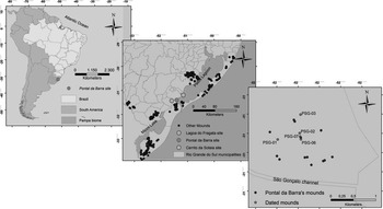
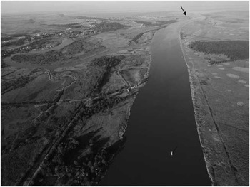
In the surroundings of Patos Lagoon, three different areas with earthen mounds have been studied from a systematic view to understand the process of regional occupation by the indigenous populations. These areas comprise the Cerrito da Soteia settlement, which was previously dated at 1400±40 BP (BETA 234207) and 1360±40 BP (BETA 234206), both dates from fish otolith samples (Loureiro Reference Loureiro2008); the Lagoa do Fragata settlement with 13 mounds not yet dated; and the Pontal da Barra settlement (Figures 2 and 3). The latter is located at south of Patos Lagoon, up to 2 m asl. The archaeological site is named after an intersection between the Patos Lagoon and the São Gonçalo Channel (Barra) (Figure 4). It is an archaeological settlement comprising 18 earthen mounds, each about 1 m high and in elliptical plans, distributed along the swamp. This site was registered in 2006, and three field trips were undertaken between 2010 and 2013 (Milheira et al. Reference Milheira, Garcia, Ulguim, Silveira and Ricardo Ribeiro2016) to describe the architectural features, understand the formation processes, and collect samples to obtain a complete 14C chronology.
Maps showing the location of the investigated archaeological sites.

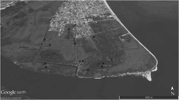
Satellite image showing the earthen mounds of Pontal da Barra site. Adapted from Google Earth, 2016.

Aerial view of São Gonçalo Channel. The arrow points to the location of the Pontal da Barra site on the shore of Patos Lagoon.

Archaeological Description
The archaeological fieldwork at Pontal da Barra consisted of targeted excavations of the mounds with the purpose of determining their formation processes and the chronology of each structure. Profile rectifying revealed the stratigraphic components of the sites, their archaeological features and material culture. From the 18 earthen mounds at Pontal da Barra archaeological settlement, 5 were studied: PSG-01, PSG-02, PSG-03, PSG-06, and PSG-07.
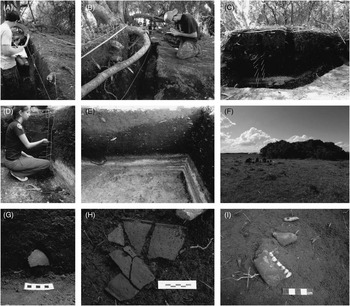
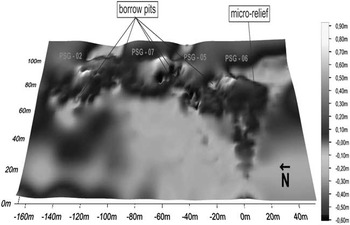
These mounds were chosen because they are easily accessible. The PSG2, PSG5 (not excavated yet), PSG-06, and PSG-07 form a complex of mounds aligned in the north–south direction (Figures 5–7). Besides, PSG-01, PSG-02, and PSG-03 mounds have been illegally exploited by the local community because of their dark earth component, rich in organic material. This activity of soil exploitation has even destroyed parts of the mounds as can be seen in the east portion of PSG-02 (see Figure 7). Another problem for the preservation of the earthen mounds is the urbanization advancing on the ground damming water in some terrain points and affecting the integrity of the archaeological sites by candles built for draining the swamp (as can be seen in Figure 3).
A) rectified profile in the PSG-01. B) rectified profile in PSG-02. C) rectified profile in PSG-03 and collection of soil samples in columns. D) rectified profile in PSG-06 and collection soil samples in columns. E) east profile of mound PSG-07 with the contrast between the anthropogenic dark earth and the natural soil of the swamp (light grey). See the convex shape of hearth at the base of mound. F) panoramic view of the archaeological excavation in PSG-06. H) sherds of a ceramic vessel collected in PSG-07. I) part of human mandible associated with ceramics and a pendant made from dolphin tooth.

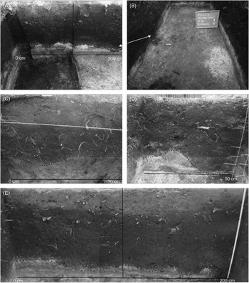
A) west profile of mound PSG-07, grid 1000N/1000E, 1001N/1000E indicating hearth features in the base of the mound. B) level 18 (90 cm deep) of the mound PSG-07, grid 1001N/1000E, 1002N/1000E, indicating similar hearth features at the base of the mound. C) hearth feature evidenced at the south of the mound PSG-01. D) similar hearth feature evidenced at the south of the grid 1000N/1000E of the mound PSG-06. E) hearth features on the north profile of grid 1000N/999E e 1000N/1000E in the mound PSG-02. Photos by Rafael Milheira.

Topographic map of the earthen mound complex PSG-02, PSG-05, PSG-06, and PSG-07, pointing to the borrow pits and the micro-relief in the mounds. Elaborated by Cleiton Silveira.

Considering the disturbance of stratigraphy caused by modern activities, the archaeological interventions were limited to profile rectifying (except for PSG-02) to prevent further impacts to archaeological sites, as archaeological activities are also destructive to some extent. Moreover, the calibration model was limited to grouping each mound results since stratigraphy could have been compromised.
The excavations performed in the Pontal da Barra’s mounds comprise an area of 15.5 m² of grid squares divided in artificial layers with 5 cm and 14.55 m of rectified profiles.
The PSG-01 mound has 22 m in the north–south axis, 28 m in the east–west axis and 60 cm in height and a 3.35 m profile was made in the north zone of mound. The recovered material consists of 231 ceramic sherds, 31 pieces of lithic material, 38 human bones, and 2.5 kg of faunal remains.
The PSG-02 was already deformed but it was estimated that the original matrix should have had a north–south axis with 46 m, east–west axis with 29 m and 1.15 m in height. On the top of this mound we excavated a trench of 3 m². At the west slope, an area of 2 m² in a T shape was dug. We also excavated two shovel test pits with 50 cm × 50 cm at the east and north parts of the site. Besides, a rectification profile of 6.5 m × 1.20 m deep was made in the east zone of the mound. The recovered material consists of 1220 ceramic sherds, 112 pieces of lithic material, 44 human bones, and 26.7 kg of faunal remains.
The PSG-03 mound was approximately 75 m long on north–south axis, 41 m on east–west axis and had 1 m in height. At the southern part of the mound, two profiles with extensions of 2.4 and 2.3 m were rectified and 132 ceramic sherds, 6 pieces of lithic material, and 6.5 kg of faunal remains were recovered.
The PSG-06 is the most prominent mound of the complex, with an elongated platform that extended to the south zone and was interpreted as micro-relief. The mound has 47 m on north–south axis, 30 m on the east–west axis and 1 m in height. On the top of the mound a trench of 3 m² was excavated. In the adjacent area, on the south, another grid square with 1 m² and a trench with 3 m² were excavated. Recovered were 801 ceramic sherds, 91 pieces of lithic material, 3 human bones, and 15.3 kg of faunal remains.
The mound PSG-07 has an almost circular shape with approximately 36 m on the north–south axis, 30 m on the east–west axis and 1.15 m in height. The excavation was performed on the top of the mound with a trench of 3 m². The recovered material consisted of 864 ceramic sherds, 47 pieces of lithic material, 4 human bones, and 0.3 kg of faunal remains.
These mounds had hearths with convex shape at their bases, verified by the contrast between anthropogenic dark earth that compose the mounds and the natural soil of the swamp (light grey). Hearths contained charcoal and fire ash and are correlated to many faunal remains, which are commonly carbonized and calcinated. These hearths can eventually appear in the upper layers, containing predominantly fire ash.
The chronology of the settlement was based on the 14C dating of fish otolith, charcoal from hearths, one human bone and one animal bone. Therefore, concerning the aquatic samples, reservoir corrections, and species habits were taken into account. The otoliths sampled are from two species of fish: Pogonias cromis (common name miraguaia/black drum) and Micropogonias furnieri (common name corvina/whitemouth croaker).
Whitemouth croaker is a migratory teleostean demersal fish found in the Atlantic Ocean from the Gulf of St. Mathias (41°S), Argentina, to northern Venezuela (20°N) (Gonçalves and Passos Reference Gonçalves and Passos2010; de Andrade Ferreira et al. 2013), whereas black drum is a demersal coastal species distributed along the western Atlantic Ocean, from Massachusetts, USA, to the south of Buenos Aires Province in Argentina (Macchi 2002).
Both species are euryhaline and have a wide distribution range in the brackish and coastal waters up to 100 m deep (Mianzan et al. 2001). These seasonal fishes spawn mainly at the bottom salinity front of the estuary, in the inner region (Militelli Reference Militelli2007). They are commonly found at the estuary of the Patos Lagoon in the summer when they migrate for breeding and spawning. They are estuarine-dependent species and live in sandy or muddy bottom. Both are carnivorous with preference for benthic organisms, feeding on crustaceans, bivalve siphons, and polychaetes (Pattillo et al. Reference Pattillo, Czapla, Nelson and Monaco1997; Denadai et al. Reference Denadai, Santos, Bessa, Fernandez, Luvisaro and Turra2015).
Pogonias cromis and the Micropogonias furnieri were, among other fish species, very significant to the economy of the mound builders of Patos Lagoon, representing around 90% of their diet (Milheira et al. Reference Milheira, Garcia, Ulguim, Silveira and Ricardo Ribeiro2016; Ulguim Reference Ulguim2010). However, farther south, the frequency of both species decline giving space to other continental animals as the Ozotoceros besoarticus, Blastocerus dichotomus, Myocastor coipus, Cavia sp., Rhea Americana and Hydrochoeris hydrachaeris (Moreno Reference Moreno2014).
MATERIALS AND METHODS
To construct a chronological model in which the marine reservoir effect is taken into account, different kinds of samples were collected including charcoal, fish otoliths, animal bones (commonly associated to hearths), and human bones possibly from secondary burials. It is important to mention that otoliths are very resistant aragonite structures not as susceptible to diagenetic processes as fish bone (Aguilera et al. Reference Aguilera, Belem, Angelica, Macario, Crapez, Nepomuceno, Paes, Tenório, Dias, Souza and Rapagnã2016; Carvalho et al. in preparation). Unlike calcinated bones, fish otolith should reflect the aquatic 14C concentration while the animals were alive.
In the laboratory, the samples were air dried for at least one week before 14C analysis. Three samples were analyzed in the Center for Applied Isotope Studies at the University of Georgia (UGAMS), 4 samples in Beta Analytic labs (BETA), and 17 in the Radiocarbon Laboratory at the Fluminense Federal University (LAC-UFF).
Each laboratory follows slightly different protocols for sample preparation and measurement. For bone samples, the collagen fraction was used. We describe the standard protocols for carbonate and charcoal at LAC-UFF, where most of the samples were analyzed. Further details on sample preparation at UGAMS and BETA labs can be found in Cherkinsky et al. (Reference Cherkinsky, Culp, Dvoracek and Noakes2010) and radiocarbon.com, respectively.
For charcoal samples, an acid-base-acid (ABA) treatment was employed with 1.0M hydrochloric acid (HCl) (2 hr at 90°C) and 1.0M sodium hydroxide (NaOH) (1 hr at 90°C). Pretreated organic samples were combusted in prebaked quartz tubes containing a silver (Ag) wire and cupric oxide (CuO) at 900°C for 3 hr in a muffle oven. Otolith samples were chemically treated with 0.5M HCl to remove the outer layer, which could be contaminated. Phosphoric acid (H3PO4) was injected with a gas tight syringe into evacuated vials to obtain CO2. Chemistry blanks used were optical calcite and reactor graphite and combustion blank was reactor graphite. The gas was purified by means of dry ice/ethanol traps in the graphitization line (Macario et al. Reference Macario, Gomes, Anjos, Carvalho, Linares, Alves, Oliveira, Castro, Chanca, Silveira and Pessenda2013). Graphitization was performed using the zinc (Zn)/titanium hydride (TiH2) method with iron (Fe) catalyst (Xu et al. 2007). Individual torch sealed tubes were heated at 520°C for 7 hr in a muffle oven (Macario et al. Reference Macario, Oliveira, Carvalho, Santos, Xu, Chanca, Alves, Jou, Oliveira, Pereira, Moreira, Muniz, Linares, Gomes, Anjos, Castro, Anjos, Marques and Rodrigues2015a). Calcite and graphite blanks as well as IAEA reference materials C2, C4, C5, and C6 are routinely prepared as control samples. Graphitized samples were pressed in aluminium cathodes, positioned into the wheel of the ion source and measured in a NEC 250 kV single-stage accelerator system (SSAMS). The isotopic fractionation was corrected by measuring the δ13C on-line in the accelerator. Background was measured using processed calcite blanks for carbonate samples and processed graphite for organic samples. Graphite and calcite processed blanks yielded average 14C/13C ratios of 6 × 10–13 and 7 × 10–13, respectively. Average machine background was 10–13 for unprocessed graphite. Accuracy was checked by measuring reference materials within the 2-σ range of consensus values.
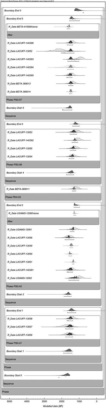
Conventional 14C results for PSG-07 were previously published in Guedes Milheira et al. (Reference Guedes Milheira, Loponte, García Esponda, Acosta and Ulguim2016). Calibration was performed with OxCal v4.2.4 (Bronk Ramsey 2009) using the atmospheric curve SHCal13 (Hogg et al. Reference Hogg, Hua, Blackwell, Niu, Buck, Guilderson, Heaton, Palmer, Reimer, Reimer and Turney2013) for all samples. For otolith samples an undetermined offset R from the atmospheric curve was considered. For bone samples a termini post quos “After” command was used to account for unknown dietary effects in both human and dog. The OxCal software performs the Bayesian analysis of the results, not only subjecting the values to the fluctuations of the calibration curves and deriving individual probability distributions of occurrence for each calibrated year, but also allowing the construction of a statistical model where groups of ages can be related in different ways and, especially in the absence of strictly paired marine/terrestrial samples, the reservoir effect can be considered for the whole set of samples (Bronk Ramsey and Lee Reference Bronk Ramsey and Lee2013; Alves et al. Reference Alves, Macario, Souza, Aguilera, Goulart, Scheel-Ybert, Bachelet, Carvalho, Oliveira and Douka2015b; Carvalho et al. Reference Carvalho, Macario, Oliveira, Oliveira, Chanca, Alves, Souza, Aguilera and Douka2015; Macario et al. Reference Macario, Souza, Aguilera, Carvalho, Oliveira, Alves, Chanca, Silva, Douka, Decco, Trindade, Marques, Anjos and Pamplona2015b; Macario et al. Reference Macario, Alves, Chanca, Oliveira, Carvalho, Souza, Aguilera, Tenório, Rapagnã, Douka and Silva2016). A group of independent phases was considered in the chronological model with a common undetermined offset from the atmospheric curve (Delta_R(“psg”,U(-100,400))) to account for local corrections for carbonate samples (Bronk Ramsey and Lee Reference Bronk Ramsey and Lee2013). It is important to note that this is a general offset command, not directly related to ΔR, defined as the difference between the local marine reservoir age and the global ocean age. Since there could be mixing of material from different archaeological contexts, we have considered a simple phase for each mound containing all the respective dates with no internal sequence assumed. Moreover, boundaries for the whole occupational period were applied. The mean value and standard deviation were calculated considering the probability function of the resulting Delta_R distribution by the OxCal software.
As an example, the code for one of the phases is detailed below. The complete code is available as supplementary material in the online version.
Sequence()
{
Boundary(“Start 4”);
Phase(“PSG-06”)
{
Curve(“=ShCal13”);
Delta_R(“=psg”);
R_Date(“LACUFF-13054”, 1652, 33)
{
color=“blue”;
Outlier(0.05);
};
Curve(“=ShCal13”);
Delta_R(“=psg”);
R_Date(“LACUFF-13055”, 1548, 59)
{
color=“blue”;
Outlier(0.05);
};
Curve(“=ShCal13”);
Delta_R(“=psg”);
R_Date(“LACUFF-140392”, 1355, 37)
{
color=“blue”;
Outlier(0.05);
};
Curve(“=ShCal13”);
Delta_R(“=psg”);
R_Date(“LACUFF-13053”, 1480, 130)
{
color=“blue”;
Outlier(0.05);
};
};
Boundary(“End 4”);
};
RESULTS
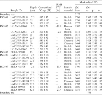
Table 1 shows the conventional 14C dates obtained for each of the 24 samples analyzed from the 5 mounds studied (PSG-01, PSG-02, PSG-03, PSG-06, and PSG-07) and the range of the modeled dates.
Depth within the mound, conventional and modeled 14C dates for each sample measured, available IRMS results. Mean values (μ) and standard deviations (σ) for the probability distributions are also presented.

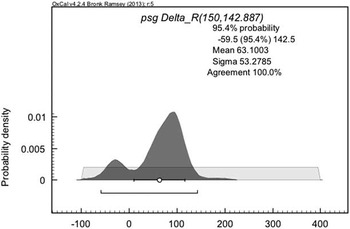
For the fish otolith samples, the isotopic concentration should reflect the surficial marine reservoir effect in this region, but the presence of the lagoonal system could cause the introduction of continental freshwater inputs. Therefore, we have used a phase model (Figure 8) in the OxCal software with an undetermined offset (representing R), ranging from –100 to 400 14C yr from the SHCal13 curve and this has produced an R value of 63±53 14C yr (μ±σ) (Figure 9).
Modeled radiocarbon dates for earthen mounds of Pontal da Barra, Southern Brazil. Probability distributions for otolith, bone, and charcoal samples. Boundaries for each phase are also shown. Lines indicate the 2-σ range, and dots mark the mean values of each distribution.

Probability distribution for the local radiocarbon reservoir offset R.

DISCUSSION
Care should be taken when comparing conventional 14C dates from different periods and especially from different materials. Due to the non-linearity of the calibration curves, different periods generate varied ranges and probability distributions of calibrated ages. As previously discussed, marine samples must be calibrated with the proper curve and, whenever available, the local reservoir effect correction has to be taken into account. Nevertheless, for aquatic samples highly influenced by terrestrial carbon sources, the use of an atmospheric curve presents itself as a reasonable option and can derive useful 14C depletion information for other local environmental or archaeological studies.
The low R value found here is discordant with available data from the marine environment of the same region (Nadal de Masi Reference Nadal de Masi2001; Eastoe et al. Reference Eastoe, Fish, Fish, Gaspar and Long2002; Angulo et al. Reference Angulo, Souza, Reimer and Sasaoka2005; Alves et al. Reference Alves, Macario, Souza, Pimenta, Douka, Oliveira, Chanca and Angulo2015a). The available data for São José do Norte, the closest to the Patos Lagoon, is a ∆R of 17±29 14C corresponding to a reservoir effect of 324±30 14C yr (Alves et al. Reference Alves, Macario, Souza, Pimenta, Douka, Oliveira, Chanca and Angulo2015a). However, to understand this apparent inconsistency, it is crucial to note that previous studies have always used samples collected from open sea localities and, therefore, less influenced by continental freshwater inputs.
In aquatic reservoirs, carbon is present in three different forms: dissolved inorganic carbon (DIC), particulate organic carbon (POC), and dissolved organic carbon (DOC). DIC comprises ionic bicarbonate, carbonate, carbonic acid and dissolved gaseous carbon dioxide (Fernandes et al. Reference Fernandes, Rinne, Nadeau and Grootes2014; Hope et al. Reference Hope, Billett and Cresser1994). Old carbonates dissolved in water (DIC) can give origin to reservoir effects of thousands of years (Lanting and van der Plicht Reference Lanting and van der Plicht1998; Hall and Henderson Reference Hall and Henderson2001; Ascough et al. Reference Ascough, Cook, Church, Dunbar, Einarsson, McGovern, Dugmore, Perdikaris, Hastie, Friðriksson and Gestsdóttir2010). POC and DOC are distinguished by the particles’ size, which is between 0.45 μm and 1 mm for the former and smaller than 0.45 μm for the latter (Hope et al. Reference Hope, Billett and Cresser1994; Fernandes et al. Reference Fernandes, Rinne, Nadeau and Grootes2014). Terrestrial inputs from rivers will contribute to organic detritus in the estuarine system. According to Attayde and Ripa (Reference Attayde and Ripa2008), aquatic systems’ food chains can be divided into two categories based on the source of energy and nutrients for the first-level consumers. While in a detritus food chain, such sources are dead organic matter, in a grazing food chain, the source of energy and nutrients is living plant biomass. Generalist carnivorous species, as top predators, may feed on both food chains but prey preferences will reflect on the sources of carbon in their composition.
Considering the feeding habits of the studied fish species, both carnivorous with preference for benthic fauna, we conclude that the low R value obtained for the Patos Lagoon reflects a mixture of both marine and atmospheric carbon signal, with enhanced contribution of detritus food chain. Seasonal variations of continental input due to winds and rain would probably lead to fluctuations in the reservoir effect. Since otoliths grow in rings composed of incremental zones (in which CaCO3 predominates) and discontinuous zones of organic matrix (Watabe et al. Reference Watabe, Tanaka, Yamada and Dean1982), a possible means to infer such variations would be the dating of such growth layers.
From the archaeological point of view, the results from Pontal da Barra reveal a long-term indigenous occupation of the site ranging from 2177 to 754 cal BP (2σ), based on the modeled calibrated dates shown in Figure 8. However, most of the dates fall within 1800 and 1200 cal BP, which indicate the period of most intense activity. Moreover, it is important to note that such wide range does not mean that the occupation has lasted for 1400 years, but that such period comprises the probability of occurrence of the dated remains.
The interpretative model is that the human occupation of Pontal da Barra started with sporadic events marked by hearths found on the base of all the excavated mounds. The hearths (Figure 6) are usually associated to ephemeral activities such as reconnaissance, temporary use and limited resource exploitation that comes before territory establishment (Iriarte Reference Iriarte2006). Hence, the mounds within Pontal da Barra were firstly occupied as camp sites when the swamp was likely explored for fishing and hunting the Patos Lagoon resources.
The intensive occupation and societal stability that incorporated the Pontal da Barra as part of the mound builders’ territory correspond to the highest frequency of dates between 1800 and 1200 cal yr BP. In a similar pattern to that described by Iriarte (Reference Iriarte2006) for Los Ajos, and Villagran and Gianotti (Reference Villagran and Gianotti2013) for Pago Lindo, archaeological sites (both located in Uruguay), the Pontal da Barra became a village with prolonged use, associated with architectural complexity marked by ritual facilities (secondary burials), disposal areas (fish secondary refuse), permanent or semi-permanent settlements, and possibly agricultural features (Milheira et al. Reference Milheira, Garcia, Ulguim, Silveira and Ricardo Ribeiro2016).
Another important question is the possible contemporaneity of the earthen mounds occupation at the Pontal da Barra. The simultaneous occupation, evidenced around 1500 BP, denotes a complex and synchronic village occupied by groups of perhaps hundreds of individuals. In this period, the significance of the Pontal da Barra has shifted from a transient fish camp, occupied seasonally, to an important permanent and sedentary settlement inside the territory of mound builders of Patos Lagoon. Obviously, during this large period of occupation, moments of abandonment must have occurred but the 14C data does not allow such precise determinations. In this way, the sedentary lifestyle is a concept that must be relativized, because abandonment and reoccupation moments were certainly dependent on the environmental conditions, political, economic, and symbolical decisions and the pressure of other human groups.
Simultaneous occupation of mounds has been described for cerritos around the Pampas and other archaeological contexts of American lowland. Iriarte (Reference Iriarte2006) published the case of the archaeological settlement Los Ajos, occupied since approximately 5000 BP, that can be described as a circular village composed of mounds used for residential function. In the central Amazon, Moraes and Neves (Reference Moraes and Neves2012) have published the case of the Laguinho do Limão site, with the mounds occupied around 1000 BP and connected to other sites of the same chronological horizon. The connection of the mound and other kinds of built structures have been described also at the Llanos de Mojos site in Bolivia (Erickson Reference Erickson2006, Reference Erickson2009), as well in the plans of the French Guiana shore (Rostain Reference Rostain2010), in the plans of Orinoco River in Venezuela (Gassón Reference Gassón2002), in Marajó Island, in the delta of the Amazon River, northern Brazil (Schaan Reference Schaan2007). In the Amazon, on the Xingu basin, there are mounds connected to villages, ports and pathways precisely described by Heckenberger (2001), as well there are mounds clearly used as burial facilities, known as danceiros, articulated to house pits in the southern plateau of Brazil (Iriarte et al. Reference Iriarte, Copé, Fradley, Lockhart and Gillam2013; Copé Reference Copé2015).
According to the 14C dates, the abandonment of Pontal da Barra occurred around 800 cal BP, reasons for which remain unclear. It is important to note that the Guarani occupation in the southern Brazilian coastline occurred from around 1000 yr ago and may have resulted in a territorial dispute, changing the cultural landscape along the coast (Noelli et al. Reference Noelli, Milheira and Wagner2014). However, in the Pontal da Barra settlement there is no evidence of external or internal violence, nor signs of strong environmental or climatic changes that could explain the abandonment. In this case, we suggest that the abandonment could have occurred through cultural decisions related to territorial mobility and the aggregation of other places around the Pampas.
The study of the Pontal da Barra archaeological complex improves our understanding of three distinct stages of human activity: exploration, colonization, and settlement. This process converted the Pontal da Barra to an important and meaningful place, abandoned only after centuries of systematic occupation. The reason of the abandonment of Pontal da Barra is not clear and remains as a relevant focus for future research.
Through the stable isotopes analysis, we shall be able to determine dietary patterns of these ancient groups. Therefore, we need not only the δ13C and δ15N data from the bones but also the stable isotopes data from the web food sources. These quantities will be part of a subsequent paper, since the right choice of the representative web food sources and their measurement require time and a solid study on the environment comprising these settlements. To promote a substantial work, we intend to include both 14C and stable isotope data from collagen of other human bone samples from the same sites, building a more complete discussion about this issue.
CONCLUSION
The earthen mounds located at the Patos Lagoon were built for different functions over time including temporary camps and residential household, refuse disposal areas, ritual places (marked by burials), and perhaps agriculture. The archaeological record indicates that hearths found on the base of the mounds suggest the beginning of occupation around 2200 cal BP, when the Pontal da Barra swamp was occupied as transient fish camps. After that, there is a clear process of architectural complexity between 1800 and 1200 cal BP, evident by the transformation of adjacent topography, including micro-relief from residential areas and borrow pits from where sediment was taken to build earthen mounds. The later period of occupation, according to the 14C dates was approximately 800 cal BP.
Finally, the chronological model allowed us to infer the freshwater influence in the aquatic samples reflected in the 14C reservoir offset R estimated in 63±53 14C yr. Such value applies only to the Patos Lagoon for the studied time period and should not be extrapolated to other regions or other time ranges. Such highly freshwater influenced value stresses the importance of specific and accurate calibration, especially when dealing with aquatic samples from estuary regions. Ongoing work on dietary effects may help to understand the freshwater influence in the area.
Acknowledgments
The authors acknowledge the National Council for Scientific and Technological Development (CNPq-Brazil) for financial support (470178/2013-2). We also thank archaeologists Tiago Atorre and Paulo DeBlasis for intellectual discussions and Dr Orangel Aguilera, Dr Rafael Tubino, and Dr Marcus Rodrigues da Costa for information on fish species and the anonymous reviewers for the useful comments and suggestions.
SUPPLEMENTARY MATERIAL
To view supplementary material for this article, please visit https://doi.org/10.1017/RDC.2017.5