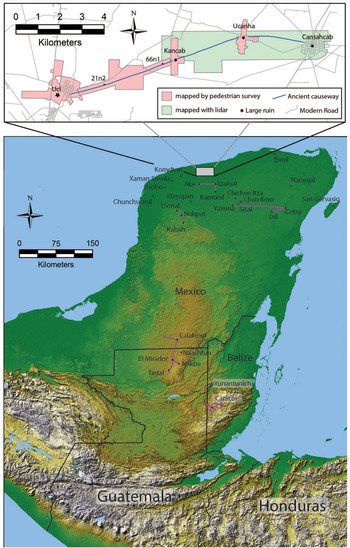
The ancient Maya of northern Yucatan built an 18 km long east–west chain of three intersite causeways linking four sites (from west to east: Uci, Kancab, Ucanha, and Cansahcab; Figure 1) and rural settlements in between. Stone causeways are a major feature of Maya landscapes, beginning as early as the Middle Preclassic (800–300 BC) and continuing even into the twentieth century at the village of Sisal, Yucatan (see Villa Rojas Reference Villa Rojas1934:197). In a sample of 293 causeways, Shaw (Reference Shaw2008:84) found that 78% measure less than 1 km long and connect buildings within sites. Most of the others measure between 1 km and 5 km. Uci and perhaps a dozen other sites, such as Calakmul, Caracol, Chichen Itza, Coba, El Mirador, Emal, Izamal, Naachtun, San Gervasio, Tintal, and Uxmal, have one or more causeways longer than 5 km (Shaw Reference Shaw2008:173). The longest of these intersite causeways spans 100 km between Coba and Yaxuna. The ancient Maya name for causeway—sakbih—appears in texts found on the Coba end of this causeway (Stuart Reference Stuart2006). Sak means white, likely referring to white plaster coatings or white limestone in the fill and retaining walls. Bih means path or road. Archaeologists often use the term sacbé, the twentieth-century Yucatec Maya word for sakbih.
Map of sites mentioned in the text (topographic map courtesy of Samantha Krause). (Color online)

In this article, we begin by arguing that pilgrimage is the usage that best accounts for these causeways’ specific form and physicality (see also Bennett Reference Bennett1930; Roys and Shook Reference Roys and Shook1966:45). Among other things, the causeways work on bodies in such a way that the experience of walking them facilitated the goals of pilgrimage. We also argue that causeways supported the formation of multicommunity polities and allowed for competition within and between them. Causeways can also symbolize local authority, but following a semiotic approach (Preucel Reference Preucel2006:55) that treats causeways as signs that are open to interpretation (Hutson et al. Reference Hutson, Magnoni and Stanton2012), we argue that such authority is negotiated in the practice of labor. Obviously, planners must convince people to put in the work to build causeways, but in many senses, there is more to work than just collecting and assembling materials.
In Yucatan and other parts of the Maya world, building, hunting, and many other activities that sustain life always take place within a moral relationship with other-than-human persons, such as the guardian spirits of field and forest (Redfield and Villa Rojas Reference Redfield and Rojas1934). Success, be it in farming, beekeeping, or other pursuits, requires feeding the guardians at every step. Thus, work involves making both things and relations, an insight highlighted by Marx (Graeber Reference Graeber2001:45). From a Western perspective, this kind of feeding—praying, burning incense, tossing maize gruel to the four directions—has an otherworldly quality. Yet Maya ontologies are monist: entities that we would sort out as sacred or profane all belong to the same (and only) order of being (Astor-Aguilera Reference Astor-Aguilera2010:6; Monaghan Reference Monaghan and Monaghan2000). Thus, making an offering to an other-than-human being is not conceptually different from sweeping a patio or clearing the weeds from a maize field. It is all work, and in Yucatan, it all falls under a single term: meyaj (Hanks Reference Hanks1990; Taube Reference Taube, Pompa, Allen, Fedick and Osorio2003:463). We argue that this relational work was critical to generating authority. In this article, we also draw attention to variation in the quality of work. Details of the Uci–Cansahcab causeways suggest that authority behind their construction was contested. Labor was a practice: a social action experienced in a context of power relations (Silliman Reference Silliman2001).
In sum, “roadwork” as explored in this article refers to the ways in which causeways contribute to the experience of pilgrimage, the symbolic work that roads do, the relational labor of satisfying reciprocal obligations between humans and nonhuman beings, and the manual task of building them.
Background
Following fieldwork between 1979 and 1982 by Maldonado Cárdenas (Reference Maldonado Cárdenas and Pacheco1995), research on the Uci–Cansahcab causeways took place as part of the Uci–Cansahcab Regional Integration Project (UCRIP; PASUC in Spanish). Beginning in 2008, UCRIP conducted extensive mapping and excavations within and beyond three of the four sites linked by the intersite causeways: Uci, Kancab, and Ucanha (Hutson and Welch Reference Hutson and Welch2014; Hutson et al. Reference Hutson, Welch, Plank, Kidder, Kosiba, Janusek and Cummins2020). We call these three sites “centers” because they have higher population densities than the surrounding terrain and architectural features (pyramids ranging from 7 to 13 m high and intrasite causeways) not seen in their hinterlands. We know less about Cansahcab because it was heavily damaged in the colonial period.
Excavations at Uci, Kancab, and Ucanha show that these sites each have Middle Preclassic occupations, dating from approximately 800 to 300 BC. In each case, the areas that would later become the Late Preclassic (300 BC–AD 250) monumental cores contain Middle Preclassic ceramics and, at Uci, major Middle Preclassic ceremonial architecture. All three sites reached population peaks in the Late Preclassic. Uci is the largest site, covering up to 7 km2, with an estimate of more than 800 households in the Late Preclassic (Hutson and Welch Reference Hutson and Welch2014). Ucanha was the next largest site, with slightly less than half as many households, but with nearly triple the number of households as Kancab. Systematic survey suggests two clear settlement clusters—one consisting of Uci and Kancab and the other consisting of Ucanha and Cansahcab (Hutson et al. Reference Hutson, Kidder, Lamb, Vallejo-Cáliz and Welch2016). These two clusters may have comprised two political units. A buffer zone of lightly populated space exists between them. Both clusters have a dominant site: Uci on the west, Ucanha on the east.
The causeways range from 5 to 9 m wide (averaging 6 m) and from 0.2 to 1.1 m high (averaging 0.5 m). We excavated six 16 m2 trenches across them: two in the Uci–Kancab causeway, three in the Kancab–Ucanha causeway, and one in the Ucanha–Cansahcab causeway. The trenches revealed that each causeway had a single construction phase. In nearby causeways that have an earlier construction phase (intrasite Causeway 6 at Uci, the Ake–Izamal causeway), their surfaces have plaster preserved under fill from later causeways. The lack of plaster surfaces in the Uci causeways means that we have no sealed contexts for secure dating. Although Maldonado Cárdenas (Reference Maldonado Cárdenas and Pacheco1995) stated that the causeways were Late Classic, the informes from the 1979–1982 fieldwork contain no report on excavations associated with the causeway.
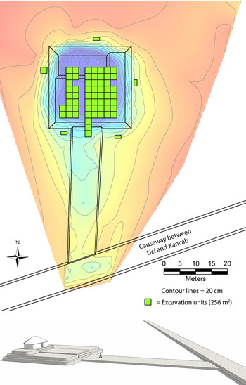
Our extensive excavations of two buildings directly associated with the Uci–Kancab causeway suggest it was built in the Late Preclassic. Structure 21N2, located 40 m north of the Uci–Kancab causeway at a distance 3 km east of the Uci site core, connects with the intersite causeway via its own 40 m long causeway, a unique occurrence in the Uci–Cansahcab causeway system (Figure 2). Ceramic evidence from 258 m2 of excavation indicates that this megalithic structure and its causeway were constructed at the end of the Late Preclassic or the beginning of the Early Classic but had a Postclassic reoccupation. Of the 826 sherds recovered, only four date to the Late Classic. The intersection of the 21N2 causeway and the Uci–Kancab causeway shows that the Uci–Kancab causeway predates 21N2, and from this we infer a Late Preclassic construction for the Uci–Kancab causeway.
Plan of Structure 21N2 showing excavation units (top) and reconstruction drawing (bottom). (Color online)

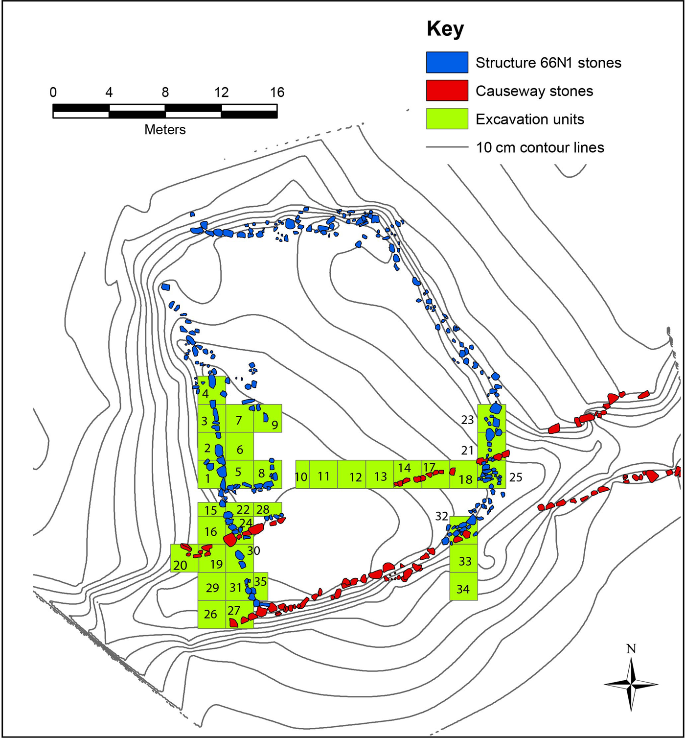
Kancab Structure 66N1, located 600 m west of Kancab's main plaza, is directly on the causeway itself (Figure 3). Excavations of 140 m2 of this megalithic platform and the causeway yielded 184 Preclassic sherds, 22 Late Classic sherds, and 52 Postclassic sherds. Units 5–9 date the western superstructure: they yielded 78 Preclassic sherds, 1 Late Classic sherd, and 23 Postclassic sherds. Because Megalithic construction is not known for the Postclassic, the structure most likely dates to the Preclassic. The structure articulates with the west retaining wall of the 66N1 basal platform, which continues southward and passes above the causeway. Thus, Late Preclassic 66N1 postdates the causeway, although the scattered Late Classic sherds suggest that the platform had a Late Classic reoccupation. Stones from the causeway's north retaining wall (in units 14 and 17) rest on bedrock and were partly buried in fill from the 66N1 basal platform, also suggesting that 66N1 postdates the causeway. Excavation units 19, 20, 26, 27, 29, 30, 31, and 35 (Figure 3) went deep into the causeway, and pottery from the lower levels dates exclusively to the Middle and Late Preclassic. Thus, three lines of evidence from 66N1 suggest a Late Preclassic date for the Uci–Kancab causeway.
Plan of Kancab Structure 66N1. (Color online)

We recognize that long-distance causeway systems at Uxmal, Izamal, and Coba date to the Late Classic but draw attention to Preclassic intersite causeways at El Mirador (Hansen Reference Hansen1991), Yaxuna (Hutson et al. Reference Hutson, Magnoni and Stanton2012), and Naranjal (possibly Early Classic; see Mathews Reference Mathews1998); Late Preclassic Causeway 6 within Uci; and several Preclassic intrasite causeways at sites near Uci, including Komchen (Ringle Reference Ringle, Grove and Joyce1999), Xaman Susula (Peniche May Reference Peniche May and Braswell2012), Yaxuna (Stanton and Freidel Reference Stanton and Freidel2005), and Xtobo (Anderson Reference Anderson2011). In the Classic period and afterward, UCRIP settlements had various historical trajectories that are not described here.
In addition to physically connecting settlements, the causeways could play several other roles (Folan Reference Folan and Trombold1991). Many ancient Maya roads facilitated the movement of goods (Carrasco Reference Carrasco, Ponce de Leon and Perramon1993; Chase and Chase Reference Chase and Chase2014; Cobos and Winemiller Reference Cobos and Winemiller2001). This is a plausible role for the causeways between Uci and Cansahcab, yet with no beasts of burden or wheeled vehicles, people did not need wide causeways just to accommodate a small amount of commerce. Causeways also helped people travel. People at northern Lowland cities like Chunchucmil and Coba had to use causeways in the course of their daily lives (Dahlin Reference Dahlin2009; Folan Reference Folan and Trombold1991). We therefore believe that, unlike Inka roads, regular people could use some causeways at least some of the time. In some places, long-distance causeways elevate the traveler above seasonal swamps (Bolles and Folan Reference Bolles and Folan2001:304) or estuaries (Covarrubias et al. Reference Covarrubias Reyna, Villanueva and Carrillo2012). Yet there are no bodies of water between Uci and Cansahcab. Thus, traveling between these two places did not require a causeway. Indeed, for millennia, most people walked long distances on narrow, unbuilt footpaths (Shaw Reference Shaw2008:129). A paved, relatively straight causeway does have advantages—it makes the route more direct, avoids mud, and would make it easier to spot venomous creatures—but a causeway does not need to be 6 m wide and 0.5 m high to afford these benefits. Such dimensions, however, work very well for ceremonial walking, as described in the next section.
Processions and Pilgrimage
Commenting on causeways at Izamal, located 33 km southwest of Uci, Diego de Landa (Reference Landa and Gates1978 [1566]) wrote that people used them for pilgrimages and processions. This should not surprise Mesoamericanists, given how common pilgrimages were and are in this region (Palka Reference Palka2014:5). The key aspect of pilgrimage in Mesoamerica is the journey from daily settings to ritual landscapes (Palka Reference Palka2014:38). Maya pilgrims both past and present had a remarkable variety of goals—maintaining cosmic balance, upholding covenants with gods, reinforcing group identity, bridging generational divides, political aggrandizing, mitigating disasters (droughts, conflicts), healing, inaugurating cycles of time, and seeking individual fulfillment, earthly renewal, rain, food, fertility, and more (Astor-Aguilera and Jarvenpa Reference Astor-Aguilera and Jarvenpa2008; Palka Reference Palka2014; Patel Reference Patel, Brady and Prufer2005).
Processions and pilgrimages can be difficult to disentangle in the Maya world because the routes for both were often sacred and the destinations ceremonially charged (Freidel Reference Freidel and Ashmore1981; Patel Reference Patel, Brady and Prufer2005). As compared to pilgrimages, which often involved many days (Astor-Aguilera and Jarvenpa Reference Astor-Aguilera and Jarvenpa2008), processions tended to be shorter. Freidel and Sabloff (Reference Freidel and Sabloff1984:82) suggested that processions took place on causeways that link major buildings and plazas within sites, whereas intersite causeways served pilgrims. Processions took many forms in the ancient Maya world (Reese-Taylor Reference Reese-Taylor and Stone2002; Sanchez Reference Sanchez2007) and often accomplished various tasks. For example, conquest-era processions from town centers to town edges in Yucatan described by Bishop Landa not only celebrated the new year and sacralized new idols but also marked the passage of political power among different segments of a town (Coe Reference Coe1965). Processions, like those depicted on the Classic period murals of Bonampak and several painted vases, involved theatrical performances, with elaborate costumes and musicians playing a variety of instruments. Those that reenacted myths of creation, such as the Maize God creating the three world realms and four cardinal directions (as described in texts from the Tablet of the Cross from Palenque), also served to legitimize the sacred authority of those performing them (Freidel and MacLeod Reference Freidel and MacLeod2000; Reese-Taylor Reference Reese-Taylor and Stone2002:147–150).
Focusing on Late Preclassic causeways, such as the one at Komchen, 40 km west of Uci, William Ringle (Reference Ringle, Grove and Joyce1999) makes several useful points about processions. Ringle proposes that processions on the causeway from a site core outward and back are attempts to mediate the concepts of center and periphery. Late Preclassic sites like Komchen were substantially larger than previous sites nearby, and emerging leaders had a stake in successfully integrating larger numbers of people for the purposes of community projects and defense. Following Victor Turner, Ringle argues that pilgrimages from a center to a symbolically untamed, dangerous periphery involve a structural inversion that brings about communitas and re-creates bonds between otherwise unequal segments of society. Helaine Silverman (Reference Silverman1994) makes a similar case for the Nazca Lines, which she argues functioned as ceremonial routes to and from the pilgrimage site of Cahuachi, Peru. Pilgrimage to Cahuachi allowed a dispersed Nasca population to contest, negotiate, or maintain social and political hierarchies under the guise of ritual (Silverman and Proulx Reference Silverman and Proulx2002). Movement along the many straight, zigzag, and figural geoglyphs of the Pampa de Nazca into and out of Cahuachi helped attendees commemorate and remember these ceremonial events in which social order was renewed or established (Silverman Reference Silverman1994).
The importance of circulation from center to periphery fits the Maya case well, given the archaeologically, epigraphically, and ethnographically documented importance of journeys to powerful places such as caves, mountaintops, and sinkholes; it is also in accord with Maya understandings of how chu'lel, the vital life force, circulates from the heart to extremities and back. Thus, Ringle argues that causeways hosted pilgrimages that provided a language for mediating and making sense of much larger and more unequal communities. Students of pilgrimage have documented discord among pilgrims (and between pilgrims and locals) and have shown that symbolic aspects of the journey and destination can be interpreted in conflicting ways, thus challenging the notion of communitas (Coleman Reference Coleman2002; Eade and Sallnow Reference Eade and Sallnow1991). Fortunately, interpretations of causeways can accommodate both notions of contestation and competition, a point to which we return.
Do data from Uci meet any expectations that causeways were used for pilgrimages or processions? We focus on four lines of evidence: physicality and experience, artifacts, way stations, and end points. The physicality of intersite causeways at Uci certainly conforms with what we would expect if they had served as procession routes. They are elevated above the ground like stages, thus not only enhancing the theatrical aspect of processions but also starkly differentiating the space of procession from the natural ground surface on either side. Unlike regular trails, their width provides space not just for walking in a line but also for dancing laterally or for multiple columns of people, at least six, parading abreast. The width and smoothness of the surface also made it easier to carry people on litters/palanquins.
The physical features of causeways also make them excellent for pilgrimages. A pilgrimage must separate pilgrims from daily life. The unusual embodied experience of walking on causeways accomplishes this task. In making this point, we follow Palka's (Reference Palka2014:42) argument that the “movement of and impacts on the human body are central to the experience of undertaking ritual pilgrimage” (see also Coleman and Elsner Reference Coleman and Elsner1994; Harrison-Buck et al. Reference Harrison-Buck, Runggaldier and Gantos2018; Skousen Reference Skousen2018). Specifically, we highlight the following aspects of embodied experience: footing, sound, smell, and atmosphere. In and around Uci, people walked on uneven, winding dirt paths the moment they left their homes. Walking normally required picking one's way with dexterity (Ingold Reference Ingold2004:325), watching for roots, rocks, and other obstacles. But smooth, paved causeways allow people to walk carelessly; pilgrims could therefore walk differently. They could try out a new gait or let the feet become “stepping machines” (Ingold Reference Ingold2004:329), thus allowing attention to shift from the ground to somewhere else: into the distance, off to the side, toward other people. These new forms of attentiveness permit learning new things as part of movement, what Ingold calls “motional thought” and knowing as you go. Yet whereas Ingold (Reference Ingold2010:S127) wrote that walking straight lines on paved surfaces normally leaves the walker in “a condition identical to that in which he set out,” we place causeway walking in another category of movement—wayfaring—in which the journey can transform the walker. Weather is important (Ingold Reference Ingold2010:S132), because rain inverts the situation, making causeways slick and grounding attention back down to footing. Sound and smell also differ between plastered causeways and dirt paths. Paths have more organic matter and leaf litter to crinkle underfoot, making sounds not heard on a causeway and emitting stronger odors. Though you may not be able to see a person 50 m ahead on a narrow, winding path, you can sometimes hear them. On causeways, you may not hear a person 50 m ahead but can certainly see them, except at night.
By atmosphere, we refer to shade, brightness, and heat. In this part of Yucatan, forests are low and scrubby. Though the canopy can reach as high as 10 m, canopy height generally ranges between 3.5 and 6.5 m high (Hutson Reference Hutson2015:253). In such forests, clearing a 6 m wide swath for the causeway would get rid of the shade, opening the causeway to the sky. Thus, constructing a causeway opened a clear, well-lit space. Sunlight made these white-plastered roads brilliantly white, contrasting with an ek beh (black road), which is a narrow path darkened by the shade of the forest above (Bolles and Folan Reference Bolles and Folan2001). The sun also heats the surface, which reflects light back upward. Spending any time on sun-soaked white plaster is a bright, sweltering experience, as many archaeologists have learned during excavations. This experience contrasts sharply with walking on a shaded, narrow path.
Thus, causeways afford a new kind of walking, out of step with the embodied dispositions durably inculcated through the much more common experience of walking along paths (Hutson Reference Hutson2010:148; see also Fisher Reference Fisher2021). This contributes to the liminality, learning, and new encounters that make pilgrimages transformative (Skousen Reference Skousen2018:265). Maya gods also go on pilgrimages, and if the movement of human pilgrims references the movement of gods (and celestial bodies; Palka Reference Palka2014:11, 58), we would expect technologies that make the experience of movement out of the ordinary.
What about artifactual evidence? In the monumental core of Xunantunich, Belize, excavations at Sacbé I and II recovered fragments of ceramic drums and items of personal adornment (a shell pendant, a jade bead, and pyrite mirror fragments), suggesting music and costuming, as well as possible offerings (Keller Reference Keller, LeCount and Yaeger2010a:199). Shell adornments were found in association with an intrasite causeway at Uci, but no excavations directly associated with the Uci–Cansahcab intersite causeways revealed fragments of musical instruments or costuming. Yet given that the Uci intersite causeway system spanned 18 km (more than 40 times the combined length of the causeways at Xunantunich), such excavations hardly even scratch the surface. Because finding musical instruments would be like finding a needle in a haystack, their absence in excavations does not indicate that they were not used in the past.
As Freidel and Sabloff (Reference Freidel and Sabloff1984) argued for Postclassic causeways on Cozumel Island, pilgrimages consisted of ritual circuits with several way stations. Pilgrims to Cozumel in the contact era were said to stop at temples along the way (Villa Rojas Reference Villa Rojas1934:207–208). Thus, we might expect stations along the route where people stopped for varied rites and activities. Structure 21N2 is an excellent candidate because it faces the intersite causeway and connects with it via its own causeway (Figure 2). Structure 21N2 consists of a 26 × 26 × 2 m basal platform and, above it on the north side, a 16 × 8 × 1 m building platform supporting a superstructure with a stone foundation brace and perishable walls and roof. Excavations identified evidence that the 40 m long connecting causeway continued on top of the 21N2 basal platform, directing pedestrians to the superstructure. The sample of Terminal Preclassic pottery and Early Classic pottery is heavily weighted toward fancy service vessels (Shangurro and Timucuy groups), suggesting ceremonial meals or offerings. Structure 21N2 required a substantial amount of work to build but has no residential community near it, suggesting that leaders at Uci commissioned its construction. 66N1 may also have been a way station, though we lack evidence for ceremonies there.
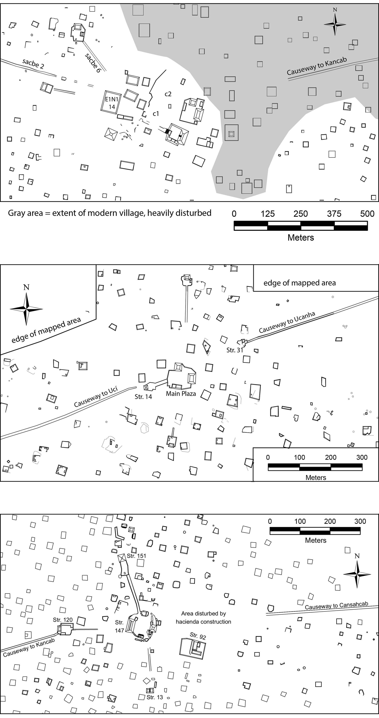
If causeways served as procession routes, we might also expect them to connect with plazas and temples. The three causeways linking Uci, Kancab, Ucanha, and Cansahcab have six end points (Figure 4):
1. The Uci end of the Uci–Kancab causeway stops about 300 m short of the monumental core, near a low platform that has been badly disturbed by settlement in the modern village of Uci.
2. The Kancab end of the Uci–Kancab causeway stops 20 m short of the back (west side) of Structure 14, a 5 m high mound that fronts its own raised plaza on its east side. A 40 m long intrasite causeway connects the Structure 14 plaza to the site's main plaza, but the intersite causeway does not provide direct access to either of these plazas.
3. The Kancab end of the Kancab–Ucanha causeway terminates at a 60 cm high basal platform that supports Structure 31 on its north side. This basal platform covers about 330 m2, whereas Structure 31 rises about 1.5 m above the platform. No intrasite causeway spans the 180 m between this compound and the Main Plaza.
4. The Ucanha end of the Kancab–Ucanha causeway terminates at the southwest corner of Structure 120. This corner gives access to the 1 m high Structure 120 plaza, which measures about 900 m2 and connects with an intrasite causeway on its east side. This intrasite causeway extends 80 m toward the Ucanha Main Plaza but stops 90 m short of Structure 147, an 8 m tall pyramid on the west side of the plaza.
5. The Ucanha end of the Ucanha–Cansahcab causeway stops about 350 m east of the Ucanha Main Plaza. The area in between the final trace of the causeway and the Main Plaza has been disturbed by late nineteenth-century construction and occupation of Hacienda Ukaná. The Main Plaza, however, is well preserved and has no trace of the intersite causeway and no space where a causeway could enter the plaza from the east.
6. The Cansahcab end of the Ucanha–Cansahcab causeway is not visible near Cansahcab due to colonial and historic period disturbance.
Maps of Uci (top), Kancab (middle), and Ucanha (bottom) site cores.

The pattern is clear: the intersite causeways do not give direct access to the main plazas at Uci, Kancab, and Ucanha. Site cores follow their own planning principles without accommodating the arrival of intersite causeways. But the causeways do get close to site cores; they do not begin at the outer edges of sites. Thus, pilgrimages brought people to the vicinity of the main performative spaces of site cores. At the east and west ends of the Kancab–Ucanha causeway, pilgrims arrive directly at architectural complexes where they may have participated in rituals that altered their state of liminality or prepared them for the next step of their journey. Most other major intersite causeways in Yucatan also do not end at major buildings or plazas. In particular, Landa correctly noted more than 400 years ago that the causeway between Izamal and Ake (only 19.5 km south of Uci) does not connect to any plaza or pyramid at Ake (Roys and Shook Reference Roys and Shook1966). The contemporary city of Izamal obscures the Izamal terminus.
Political Integration
Although the Uci–Cansahcab intersite causeways did not link people directly to major plazas, they obviously integrated multiple sites. If, as Ringle argues, Late Preclassic intrasite causeways hosted processions that provided a language for mediating and making sense of newly enlarged and more unequal communities, intersite causeways may have hosted processions and pilgrimages that provided a language for mediating and making sense of multicommunity polities. Intercommunity pilgrimages documented ethnographically in Yucatan foment intercommunity solidarity (Astor-Aguilera and Jarvenpa Reference Astor-Aguilera and Jarvenpa2008). Even without formal pilgrimages, the use of causeways to get from one site to another produces and reproduces the awareness of integration. Because Uci was the largest site linked by these causeways, it is tempting to see the construction of the causeways as a demonstration of Uci's emergence as a regional capital. Yet UCRIP research suggests that other sites on the causeway retained at least some independence (Hutson and Welch Reference Hutson and Welch2014). Excavations at Ucanha, the second-largest site in terms of both population and monumental architecture, revealed evidence of Late Preclassic politico-religious innovations at Structure 92, including a structure adorned with a mat design, which likely signifies its function as a popol nah, or council house, and a building adorned with two large stucco masks (Hutson et al. Reference Hutson, Welch, Plank, Kidder, Kosiba, Janusek and Cummins2020). Uci also had large stucco masks bracketing a stairway, although they are no longer preserved.
We have argued elsewhere that Uci and Ucanha each headed small, independent polities in the Late Preclassic and may have been in competition (Hutson et al. Reference Hutson, Kidder, Lamb, Vallejo-Cáliz and Welch2016). The Uci polity encompassed Kancab, and the Ucanha polity encompassed Cansahcab. Settlement in between these two projected polities, in the buffer zone between Kancab and Ucanha, was sparse. Ringle (Reference Ringle, Grove and Joyce1999:211–212) suggests that pilgrimage to Late Preclassic religious cults was a means for recruiting labor and wealth amid intercommunity competition. Insofar as natural landscape features, such as caves and cenotes (wet sinkholes), can be important pilgrimage destinations often envisioned as dwellings of deities (Palka Reference Palka2014; Patel Reference Patel, Brady and Prufer2005), it makes sense that both Ucanha and Uci contain multiple cenotes, whereas Kancab and Cansahcab do not. In fact, people at Uci and Ucanha appear to have chosen the location of their site cores based on the presence of caves that reach the water table (Hutson and Welch Reference Hutson and Welch2014:434). Furthermore, Uci may have established itself as a cult center in the Middle Preclassic with the construction of a temple with serpent iconography in the earliest levels of Structure E1N1–14. Maya pilgrims often bring offerings that can be appropriated by leaders (Palka Reference Palka2014:47). Leaders promote pilgrimage shrines as a way of competing for settlers and other benefits (Freidel Reference Freidel and Ashmore1981; Palka Reference Palka2014:56, 95). Causeways may have facilitated pilgrimages from Kancab to Uci, and from Cansahcab to Ucanha, helping centralize wealth and labor in those two sites.
The construction of the Kancab-Ucanha causeway linked all four sites; following Kurjack and Andrews (Reference Kurjack and Wyllis Andrews V1976) we infer an alliance among these four. Though Uci was largest, just because a settlement dwarfs its neighbors does not mean it also dominates them politically. The new causeway that finally linked all four sites may have signified not the capitulation of Ucanha to Uci but rather the expansion of pilgrimage routes, scaling up the geographic extent of intersite competition and facilitating centralization. Thus, it is possible that causeway construction did not result from political centralization, but rather political centralization resulted from causeway construction, perhaps unintentionally. Such an outcome, if it occurred, was short-lived. Instead of a single site emerging as politically dominant in the Classic period, Uci, Ucanha, and Kancab saw major population declines concomitant with the meteoric rise of nearby Izamal (Millet Cámara and Burgos Villanueva Reference Millet Cámara, Villanueva, Rubio and Gubler2006).
To summarize, ethnohistorical sources, the form of the intersite causeways (elevated and wide), the Structure 21N2 way station outside Uci, causeway end points, and the presence of watery caves in Uci and Ucanha all suggest the causeways were used for pilgrimages and processions. We also argue that causeways and pilgrimage make intelligible the emergence of novel multicommunity polities and provide avenues for competition between and within such polities, paving the way for even more complex conjunctions. Though intersite causeways and pilgrimage may not factor into the smooth succession of leadership positions (Coe Reference Coe1965) or the synthesis of site center and site periphery (Ringle Reference Ringle, Grove and Joyce1999), they may benefit local leaders by attracting pilgrims and offerings. We now turn explicitly to additional ways in which causeways and local authorities worked together.
Avenues of Authority: Relationality and Rectitude
As mentioned earlier, certain processions reenact creation, endowing performers with primordial authority. In this section we explore additional meanings of causeways that make them a means for leaders to communicate and reproduce authority. Specifically, we suggest that causeways helped leaders (1) demonstrate their ability to stabilize relations with other-than-human beings, (2) provide symbolically safe spaces, and (3) promote a veneer of rectitude. Each of these could have helped overcome social divisions within communities.
Ringle (Reference Ringle, Grove and Joyce1999:202) wrote that “pilgrimages mark a transition from the protective sphere of culture to the very edges of the world, and hence involve danger.” Many Maya speakers recognize a distinction between human space, seen as ordered, and forest, seen as a chaotic, dangerous place inhabited by potentially malevolent spirits (Hanks Reference Hanks1990:306–307; Taube Reference Taube, Pompa, Allen, Fedick and Osorio2003:466; Wisdom Reference Wisdom1940:426). The three intersite causeways in the Uci–Canshacab system extend several kilometers into less densely populated terrain. In between Kancab and Ucanha, the area of lowest density, some segments of the causeway are more than 500 m from the nearest residential compound. Although perhaps none of this space should be considered “wild” in the sense of being unaffected by humans, forests likely covered portions of it. In between Uci and Kancab and between Ucanha and Cansahcab, rural settlement is denser, but the path of the causeway is often at least 200 m away from the nearest residential compounds, not all of which were occupied at the same time. To achieve sustainability, both large sites like Uci and rural communities must have maintained forests for firewood and other needs (Robin Reference Robin2013). Thus, the causeways likely passed through forest, in addition to agricultural fields and fallow brush.
Brown and Emery (Reference Brown and Emery2008) argue that the danger is not so much in the forest itself but in crossing the threshold into and out of forests. Although the time depth of these notions of danger can be questioned (the forest–nonforest boundary sharpened with Spanish colonial policies that congregated homes into towns), the covenant-like relations between humans and powerful nonhumans run well into the Preclassic. Safely conducting any enterprise in the forest requires making offerings to these other-than-human beings. Thus, the work of building a causeway represents not just cutting through forest and assembling thousands of cubic meters of limestone but also the knowledge and resources for making offerings. Leaders who organized and funded such work displayed their ability to manage relations with other-than-human beings.
The fact that the intersite causeways passed through at least some patches of forest might also account for causeway width. As Hanks (Reference Hanks1990:306–311) and Taube (Reference Taube, Pompa, Allen, Fedick and Osorio2003:467) note, Maya conceptions of being “in” the forest mean being “under” it, in the darkness amid danger. In contrast, open spaces (milpas or plazas) are in the light and are made safe through appropriate forms of work: they have been cleared and spiritually ordered. As we noted earlier, constructing a causeway opened a clear, well-lit space that is no longer under the forest. In addition to showing the ability to manage relations with other-than-human beings, causeway builders provided their polity a symbolically tamed, safe space for travel. Could the process of linking settlements via causeways be seen as a taming of the spaces between those settlements, a service to the people traversing them, and a testament to the strength of those who brought these ambitious projects to life?
Bih, the second part of sakbih, the Classic period word for a stone causeway, means path or road. Both bih and b'eh/bej (the colonial/modern Yucatec version of bih) refer to much more than a physical road. “The image of the road,” wrote Munro Edmonson (Reference Edmonson1982:76), “is central to Yucatecan cosmology. Life is a road. Fulfilling one's road is achieving one's destiny.”
The Maya envisioned an ideal road as a long, orderly, and straight journey through one's work and life (Keller Reference Keller, Snead, Erickson and Darling2010b:145). Maya words for straight, such as toh in Yucatec, mean not just linear but also truthful, just, and morally righteous (Taube Reference Taube, Pompa, Allen, Fedick and Osorio2003:465). This may help account for the straightness of causeways that link leaders’ residences, plazas, and temples within civic centers. Portions of the causeways between Uci and Cansahcab are extremely straight, as we discuss later, in contrast to smaller, maze-like pathways (cf. Hare and Masson Reference Hare, Masson, Marken and Arnauld2021; Hutson Reference Hutson2010:148–149) not constructed under the auspices of central authorities. Straight roads also make pedestrians more visible and legible, a common project in certain forms of statecraft (Foucault Reference Foucault and Sheridan1977; Scott Reference Scott1998). Several authors have argued that part of Maya rulers’ authority depended on their ability to provide a coherent moral order and to build trust among followers (Golden and Scherer Reference Golden and Scherer2013). Insofar as long-distance causeways are emblems of one's status and destiny as a ruler, building them straight may have communicated the metaphorically straight and morally righteous nature of the ruler's work and bearing.
Work as Labor
In the previous section, we suggested that causeways did more than just provide infrastructure for pilgrimages and mark alliances between sites: they also created and reinforced local authority by communicating a leader's moral rectitude and ability to overcome danger by working to satisfy obligations with other-than-human beings. Causeways benefited both leaders and followers, and their construction attests to collaboration. Yet not everyone accepts leadership to the same degree. Details of the actual paths of these causeways suggest the tenuousness of the authority described in the previous section. By highlighting the possibility of struggle, we treat labor as practice (Silliman Reference Silliman2001). For Marx, work becomes labor when someone else requires it or appropriates its fruits. Treating causeway building as labor therefore presumes unequal relations. Although the causeways themselves do not tower over the landscape, their construction required a massive amount of effort: the volume of any of the three causeways exceeds the volume of any pyramids in the area. Thus, getting the job done required both collaboration and inequality: hundreds of people following the plans of or taking orders from a much smaller number of leaders.
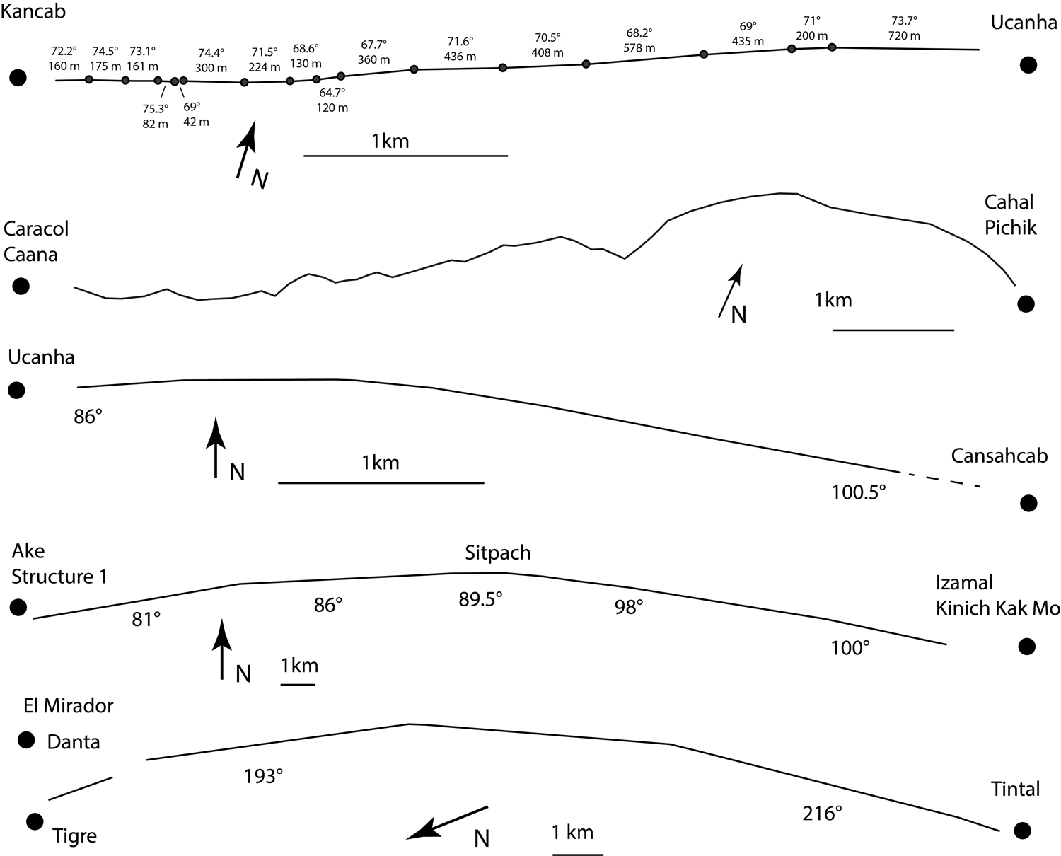
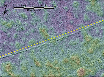
The details that suggest the tenuousness of authority include two patterns that are also visible in other Maya long-distance causeways: (1) a big bend in the causeway between Ucanha and Cansahcab and (2) many small bends (a zigzag pattern) on the other two causeways. Pedestrian survey and lidar revealed both patterns. It is no secret that intersite causeways bend (Shaw Reference Shaw2008:67–69). From the perspective of labor as practice, we suggest that both patterns (big and small bends) represent negotiation and compromise. Figure 5a shows the zigzag pattern of relatively small bends on the Kancab–Ucanha causeway (see also Figure 6). In other regions, hills partly explain such bends. For example, the causeway from the Caracol site core to Cahal Pichik (Chase and Chase Reference Chase and Chase2014; Figure 4), located 10.5 km east–northeast as the crow flies, meanders between 22° and 112° across notoriously uneven terrain (Figure 5b). For the Coba–Yaxuna causeway, Rohrer and Stanton (Reference Rohrer, Stanton, Pennanen and Goosney2019) argue that small hills blocked straight lines of sight during the construction process, resulting in subtle bends. Yet bends in the causeway between Kancab and Ucanha cannot be explained by hills, because hills reach only 1.2 m tall, not high enough to block vision. Indeed, we have cases where causeways keep the exact same orientation on both sides of a (low) hill. In addition, there are bends without hills (also the case for the Yaxuna–Coba causeway; see Rohrer and Stanton Reference Rohrer, Stanton, Pennanen and Goosney2019:Figure 8). Nor can the slight changes in orientation be due to builders’ attempts to avoid sinkholes or preexisting platforms, because none exist along the course of the causeway between Kancab and Ucanha.
Precisely mapped long-distance causeways: Kancab–Ucanha, Caracol–Cahal Pichik (adapted from Chase and Chase Reference Chase and Chase2014), Ucanha–Cansahcab, Ake–Izamal (from Google maps), and El Mirador–Tintal (adapted from Morales-Aguilar et al. Reference Morales-Aguilar, Douglas Mauricio, Hansen, Hernández, Arroyo, Méndez Salinas and Paiz Aragón2015).

Lidar digital elevation model (DEM) of a portion of the Kancab–Ucanha causeway, showing bend and imaginary straight line. (Color online)

Unfortunately, we know rather little about ancient Maya surveying. Colonial land title documents from Yucatan and El Salvador indicate that landmarks that delimited boundaries (often stone piles in Yucatan) were more important than the distance between landmarks or the straightness of lines between them. Distances (and routes) were often incorrectly recorded or not mentioned at all (Hanks Reference Hanks2010:289–290; Restall Reference Restall1997:201–203; Sampeck Reference Sampeck2014). In 1931, ethnographer Robert Redfield observed people from the village of Chan Kom, including his informant Eustaquio Ceme, cut a straight, 13 km path from their village to Chichen Itza. They built a tower of wood and vine to establish sight lines, but Ceme also climbed trees and consulted with a professional surveyor from Mérida (Redfield and Villa Rojas Reference Redfield and Rojas1934:285–290).
Whatever the method, the surveyors/builders of the Uci–Cansahcab causeways could certainly keep a straight line for an appreciable distance when they wanted to. There is a perfectly straight 500 m segment near Uci and a 720 m segment at the east end of the Kancab–Ucanha causeway whose orientation varies only by 0.2°. The builders repeated this feat on the eastern half of the Ucanha–Cansahcab causeway, which contains an almost perfectly straight 800 m stretch embedded within a 1.95 km segment whose orientation varies by less than one degree. Rohrer and Stanton (Reference Rohrer, Stanton, Pennanen and Goosney2019) note that the Yaxuna–Coba causeway is quite straight as it leaves Coba and suggest that, near this enormous ancient city, planners could count on better engineers and larger labor crews. As causeways approach big sites, their qualities were open to evaluation by many more people, perhaps motivating leaders to make causeways straighter in those places where they were most commonly observed. Along the Uci–Cansahcab causeways, sometimes the straight segments are near the big sites (for example, the western end of the Uci–Kancab causeway, the eastern end of the Kancab–Ucanha causeway, and the east end of the Ucanha–Cansahcab causeway), but sometimes they are not (for example, the west end of the Kancab–Ucanha causeway and the west end of the Ucanha–Cansahcab causeway).
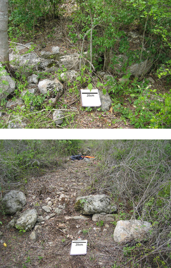
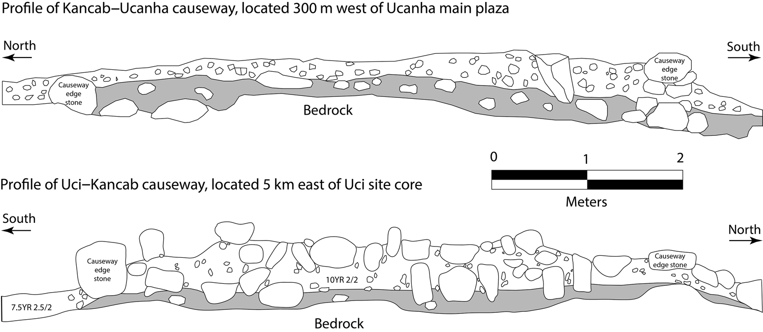
Perhaps the existence of different work crews (Folan et al. Reference Folan, Kintz and Fletcher1983:82; Keller Reference Keller, LeCount and Yaeger2010a) explains the fact that some parts of causeways run straight and others bend. Four lines of evidence suggest there were multiple work crews on the Uci–Cansahcab intersite causeways. First, the size of retention stones varies from place to place. In a spot 3 km east of Uci, stones in the retaining wall measure up to 1.2 m (Figure 7). Along most of the rest of the intersite causeways, retention stones average 0.6 m. Second, in most places the retaining walls consist of a single course of facing stones, whereas 1 km east of the Uci site core, the causeway was built with two courses of stone (Figure 7). Third, the two trenches across the Uci–Kancab causeway east of Uci revealed long, unworked stones set vertically in the fill, whereas such fill stones are absent in the other five causeway excavations (Figure 8). Fourth, in a spot 1.2 km east of the Uci site core, there is a stone alignment in the fill of the causeway running perpendicular to the causeway's direction, suggesting the end of one section and the beginning of the next. Did such an alignment mark the bounds of responsibility of different crews?
Uci–Kancab causeway showing large stones (top) and a two-course retaining wall (bottom). (Color online)

Causeway profiles showing different types of fill.

Assuming that there were different work crews, it could be that one crew labored under more exacting standards than another crew, thus building straighter causeway segments.
But why would one crew have worked harder than another? Were some laborers less committed to the project, perhaps just doing what was minimally necessary to get the job done? Interpretations of monumental building projects have softened over the years. From Giza to Cahokia, archaeologists have settled on the position that leaders could not coerce laborers. Instead, laborers’ motivation came from the lure of a good feast, the drive to make something valuable for the community, competition between work gangs or factions, or the prospect of social integration (Hawass Reference Hawass1997; Lehner Reference Lehner, Pacifico and Truex2019; Lucero Reference Lucero2007; Pauketat Reference Pauketat, Dobres and Robb2000). Theories of practice, which cast laborers as savvy actors with at least a partial understanding of the awards and constraints structuring their participation in building projects, rightfully inform these ideas. Those who built the Uci–Cansahcab causeways had good reason to collaborate with leaders in constructing them: the causeways, we have argued, boosted their experience of pilgrimage, and successful pilgrimages have many collective benefits both for humans and spiritual entities (Palka Reference Palka2014:11). But moving heavy rocks in the hot sun is hard work. A laborer can recognize how joining a work crew preserves or advances his or her own (or group) interests while at the same time wanting to get the job done without extraordinary sacrifice, perhaps easing effort here and there in subtle, hidden ways (Scott Reference Scott1985). This would not be accidental human error but rather an intentional cutting of corners.
If the bends in the causeway are part of a hidden transcript, were they truly hidden? Though lidar allows us to detect these relatively minor changes in the direction of the causeway, some bends might be undetectable to the naked eye while walking the causeway during the day. Yet things change at night (Gonlin and Nowell Reference Gonlin and Nowell2018). For example, due to a 9.5° bend, burning torches in a nocturnal procession on the Kancab–Ucanha causeway 800 m east of the Kancab terminus would not be visible from a spot on the causeway 650 m to the east (Figure 6). Still, we doubt anyone noticed this lapse in rectitude, even if there were nocturnal processions. Can we read in this lapse of exact surveying a concealed form of resistance, or is it simply the case that some crews had more experience than others, such that small lapses in rectitude were not purposeful but merely accidental? We may never know, but we feel that inferring muted inconformity is just as plausible an explanation as human error.
The Ucanha–Cansahcab causeway has a single big curve as opposed to small zigzags. A walker moving eastward from Ucanha encounters a consistent bend to the south (to the right) (Figure 5c). The causeway begins at an orientation of 86° and then gradually curves 14.5° southward to 100.5° at 2 km into the walk. If the goal of the causeway were simply to build a straight road from the monumental core of Ucanha to the monumental core of Cansahcab, we would expect a causeway that begins and ends with a bearing of 95.6°. Yet the Ucanha–Cansahcab causeway bends 14.5°, a clear detour north of the straightest possible route, adding additional labor. The Ake–Izamal causeway, 29.5 km long as measured in GIS, makes a 17° detour. It heads east from Ake and, in the vicinity of the site of Sitpach, gradually curves toward Izamal (Figure 5d). The El Mirador–Tintal Causeway gradually curves 23°, from 193° to 216°, passing through multiple sites (Figure 5e). Yet for the Ucanha–Cansahcab causeway, the lidar map shows no plausible destinations—no large architectural group or other salient feature—toward which the causeway bends nor any topographic features on the straight-line route that would require a change of direction.
Another explanation would be to say that the causeway is not just a route but is also an integral part of city planning, and therefore its alignment as it leaves Ucanha would conform to the Ucanha city plan, not the bearing of the destination. This is precisely the case with Sacbé I at Xunantunich (Keller Reference Keller, LeCount and Yaeger2010a). But the Ucanha–Cansahcab causeway's starting alignment, 86°, is not in line with any of the major buildings in the Ucanha site core, which have orientations of between 101° and 110°.
We suspect the causeway planners chose the 86° alignment so they could avoid hitting residential compounds that would have been in the way. Five residential platforms would block the causeway if it began at the Main Plaza and followed the most direct line to Cansahcab, an orientation of 96.5°. Though none of these five platforms have been excavated, excavations at two nearby platforms (Structures 459 and 546) revealed major Late Preclassic occupation (excavations at a third nearby platform did not provide a sufficient sample of pottery for dating). Thus, it is likely that people occupied some of the platforms along the straightest possible route of the Ucanha–Cansahcab causeway when it was being planned. It is tempting to say that the causeway bends because its designers and backers lacked the clout or the will to dispossess these people of their homes. If this is correct, it stands as another reminder of the partial nature of authority.
Conclusion
Of the many functions posited for long-distance causeways in the Maya area, ceremonial and political ones best fit the Uci–Cansahcab causeways. Various lines of data presented here expand on several dynamic processes, which we group under the term “roadwork.” The height and width of the Uci–Cansahcab causeways, the sensory experience of walking them, and the way station at Structure 21N2 indicate that people used them for processions and pilgrimages. Such usage would familiarize people with the emergence of novel multicommunity polities. Though Uci was the largest of the centers connected by the causeways, innovative politico-religious architecture at the second largest site, Ucanha, suggests some degree of independence between the two sites, allowing for continued competition between them. Both sites were constructed among caves reaching the water table and may have been cult centers vying for pilgrims who would bring labor and resources. Thus, the causeways do not just signify a particular political arrangement but also serve as roads to further political developments among competing centers.
The causeways are also advocates for the authority of leaders. Construction of a straight physical road across forested terrain is a way for a leader to show moral righteousness and that he or she works to fulfill reciprocal obligations with other-than-human entities that make life and prosperity possible. To the extent that relations with other-than-human beings are uncertain, authority accrues from demonstrating the capacity to manage these relations and forces from putting in the work.
The physical work on Uci's causeways was of uneven quality. The roads were straight in some places but not in others. In one case, a large bend suggests that leaders lacked the will or clout to remove people settled on the straightest route and had to commit extra resources to divert the causeway around existing houses. In other cases, little bends in the path of the causeway might attest to some laborers’ wavering commitment to the construction project. Though one could instead attribute these erratic bends to unintentional human error, such a conclusion ignores the view that labor is practice. This view explores the actual experience of work from the bottom up and posits that labor is a nexus of contestation. Labor is practice, but we also suggest that practice, in this case walking, calls attention back to labor. The very different kind of walking afforded by causeways may have called attention to the achievements and choices of laborers themselves as opposed to the leaders who organized the labor and may have claimed credit. Walking politicizes.
In sum, roadwork involves many processes with a variety of outcomes. One can infer both constitution and contestation of authority, depending on one's point of view. Admittedly, some of these interpretations suffer the same weakness as other interpretations of causeways: we do not know why people built intersite causeways in some places but not elsewhere. When people did build them, settlement survey, excavation, and close attention to the materiality and embodied experience of causeways and associated features help inject dynamic social processes into features set in stone.
Acknowledgments
We thank the Consejo de Arqueología (INAH) for permitting this work (oficios 401-36/1032, 401-36/0296, 401-36/1454, 401-36/0588, 401.B(4)19.2013/36/0320, and 401.B(4)19.2013/36/2418). Funds came the National Science Foundation (BCS-1063667), the Waitt Foundation (#W10-08), and the University of Kentucky. We thank Bill Ringle, Chelsea Fisher, Céline Lamb, Daniel Vallejo-Cáliz, Barry Kidder, Megan Parker, and four anonymous reviewers for helpful suggestions. We thank Rubén Maldonado for giving us access to unpublished data.
Data Availability Statement
Most data are available as field season reports archived at http://mesoweb.com/informes/informes.html. Due to data sensitivity issues, lidar DEMs are not publicly available.