

The ḥaḍar/sedentary versus badū/nomadic distinction has for centuries been “the axis dividing the population [of Arabia] into two districts.”Footnote 1 However, as Madawi Al-Rasheed argues, historically ḥaḍar and badū were not necessarily isolated groups. Though they developed their own identities through the ages, the oases and towns of the region “had always been engaged in intense social, economic, and political interaction” with the desert, which “fostered the existence of cultural continuity rather than dichotomy.”Footnote 2 This was certainly true of Kuwait's population historically. Kuwait Town was settled in 1716 by a group of families of the ʿAnizah tribal confederation that migrated from central Arabia to the Gulf coast to escape drought and famine. Over the ensuing centuries Kuwait developed into a prosperous trading and maritime town that regularly attracted immigrant groups (both nomadic and settled) from Najd, southern Iraq, Iran, Baluchistan, Yemen, Oman, and the southern Arab Gulf coast. By 1904 the territory of Kuwait consisted of the town with 35,000 inhabitants, a handful of agricultural and fishing villages with a total of 2,000 residents, and an expanse of desert containing around 13,000 nomadic Bedouin (badū in local parlance). The latter were tribes whose dīras or tribal territories were within the jurisdiction of the ruling Al Sabah.Footnote 3 Though they adopted new social and economic lifestyles after settlement, most town-dwellers and practically all villagers (such as the ʿAwazim, settled in Dimna, present-day Salmiya) shared lineage with the desert tribes, reflecting the porosity of these social categories.Footnote 4
With the launch of the oil industry in the late 1940s, Kuwait's nomadic Bedouin began settling in large numbers as new employment opportunities became available in the country's burgeoning oil and industrial sectors. Abandoning their nomadic pastoral lifestyle, Kuwait's last remaining Bedouin began their transition into urban life. This process was documented by Zahra Freeth—the daughter of the British political agent H.R.P. Dickson, who grew up in Kuwait in the 1930s—during a trip back to the country in 1970:
Just as the conditions of the desert shaped the rules by which they lived . . . the new settled life which so many badu are adopting when they become wage-earners will in its turn suggest a new set of rules to meet the demands of a sedentary suburban existence. So the badu will change . . . To the children who are going to school today the old values and traditions will be largely irrelevant, for they will be trained to a way of thought suited to the competitive world of a modern industrial society. They may still take a pride [sic] in their tribal origins, may still say for a generation or two ‘our people were badu’, but those who grow up never having lived in a tent nor taken flocks and herds to pasture will not be badu . . . They will be town Arabs. The word badawin cannot be applied to those who work for wages, live in a house, eat regularly and well, and find their amusement in the cinema. At the moment the badu are still in a stage of transition, marked by a curious intermingling of old customs and new ways.Footnote 5
Today, nearly 99 percent of the country's population is settled, and Kuwait hardly contains any Bedouin who practice a nomadic or pastoral lifestyle. Practically all Kuwaitis are now urbanized, and ḥaḍar and badū therefore do not exist as distinct, ontological entities. Yet as cultural anthropologist Anh Nga Longva argues, “far from slipping into oblivion as a result of urbanization,” and despite Freeth's predictions in 1970, the term badū remains in popular use in Kuwait today to designate a group considered sociologically and culturally distinct from the ḥaḍar (the townspeople).Footnote 6 Moreover, as Longva demonstrates in her 2006 analysis of this ḥaḍar/badū dichotomy in Kuwait, popular discourse reflects a deep-seated animosity between these two groups, one that is assumed to reflect a historical opposition between ḥaḍar and badū that existed well before the coming of oil. This article continues Longva's search for why this dichotomy still exists in Kuwait, but with some significant analytical differences.
While popular discourse in Kuwait today primarily cites cultural incompatibility as the reason for this dichotomy, wide and discordant cultural gaps between ḥaḍar and badū were not pronounced in the pre-oil era.Footnote 7 Longva argues that “we need to understand the ongoing hadhar criticism of the badu as an expression of anti-immigration feelings, of the kind one commonly hears in societies where the state has pledged to take in charge the cradle to grave welfare of its citizens.”Footnote 8 That is, ḥaḍar animosity toward the badū stems from not wanting to share the nation's wealth with perceived newcomers. While Longva's analysis provides an important contribution to our understanding of this dichotomy, it is incomplete, because not all who are designated as badū in Kuwait today are in fact newcomers. Longva's study, which focuses primarily on discourse and perceptions that existed at the time of her research between 1997 and 2004, contains some historical gaps that the current article seeks to fill. To explain the existence of a ḥaḍar/badū dichotomy today despite the fact that nearly all of Kuwait's inhabitants are now settled urbanites, we need to identify the historical factors that contributed to this dichotomy. What hindered the outcome Freeth envisioned in 1970, whereby the badū would be assimilated and the term no longer used to designate a distinct social group?
While agreeing with Longva that historical–cultural incompatibility is not a sufficient explanation, the main argument of this paper is that the existence of the ḥaḍar/badū dichotomy in Kuwait today is an outcome of state-building strategies adopted in the early oil decades of the 1950s and 1960s, and maintained through the 1980s. It has been well-established by political scientists like Jill Crystal, Nicolas Gavrielides, Shafeeq Ghabra, and Abdullah Alhajeri that after the creation of the Kuwaiti parliament in 1963 the badū became the primary political allies of the Al Sabah rulers and a counterbalance to the long-standing political opposition of the merchants (the rulers’ historical adversaries, whose demands for power-sharing escalated in the 1930s) and nationalist progressives (who became the dominant opposition force in the 1950s), both of which were urban groups. Certain naturalization and electoral districting policies implemented from the late 1960s onwards established the “tribes” (qabāʾil) as a distinct political category and ensured their political support for the government. Though discussing these particular state-building strategies that, whether intentionally or inadvertently, pitted the ḥaḍar and badū against each other in the realm of politics, this paper steps away from the common political analysis and examines the implementation and impact of various state policies at the more micro level of lived reality to explain why the ḥaḍar/badū dichotomy still exists and where the antagonistic sentiments that frame this dichotomy come from. Against this historical background, we can better understand a new and perhaps unexpected development that has occurred in Kuwaiti politics in the years since Longva's 2006 article: the transformation of the badū from the Al Sabah's main loyalty base to their primary and arguably most confrontational opposition in history.
The fact that the rulers’ erstwhile supporters have become their principal adversaries suggests a failure in early state-building strategies that sought to use the badū to offset other oppositional forces. In her article on state-building in kin-based societies in the Middle East, Mounira Charrad identifies three strategies that central powers in postcolonial nation-states have used toward local patrimonial networks (specifically tribes) in processes of state formation: full marginalization, full integration, or shifts between periods of one or the other.Footnote 9 In Kuwait's case, although we see evidence of both integration and marginalization in the state's treatment of the badū from the 1950s onwards, these did not occur in shifts; rather, political integration and social marginalization occurred simultaneously. This incoherent reality made state strategies toward the badū untenable in the long term.
It is important to note here that tribes have not been the only group to be co-opted as political allies by the government. Several studies on Kuwaiti parliamentary politics have clearly demonstrated how, after independence in 1961 and the loss of British backing, Kuwait's rulers regularly searched for political allies to balance their old urban merchant adversaries with Bedouin, Shiʿa, nationalist progressives, and Islamists, “in turn politicizing each community” and constantly needing to restrategize to maintain political equilibrium.Footnote 10 Such strategies are of course common in many political systems, and it is not my objective to assess their validity, success, or failure in the Kuwaiti context. Rather, my aim is to analyze how such strategies relate to questions of integration and marginalization in the particular case of Kuwait's badū population, and to highlight the spatial dimensions of these issues in an attempt to answer Longva's question as to why ḥaḍar and badū still exist as seemingly fixed and mutually exclusive social categories today. This dichotomy cannot be divorced from a discussion of a spatial politics that fixed the ḥaḍar and badū as not only distinct but also geographically bounded groups.
French urban theorist Henri Lefebvre argues that in order to impose and consolidate its control, the modern state apparatus organizes both space and society in a manner that ensures “the homogeneity of the whole, and the segregation of the parts.”Footnote 11 In Kuwait, the homogeneity of the whole was established through the provision of Kuwaiti citizenship and access to cradle-to-grave welfare benefits, which ensured citizens’ full dependence on the state. The “segregation of the parts” was primarily realized through state housing policies that divided the population into discrete social residential zones and, through the provision of different and unequal standards and facilities within these different districts, created a “hierarchy of spaces” associated with particular social groups (with the former townspeople at the top and the newly sedentarizing badū at the bottom).Footnote 12 The bulk of this article focuses on state housing policies implemented from the 1950s through the 1980s which, I argue, prevented the integration of the badū into Kuwaiti urban society despite the fact that they were no longer technically Bedouin (hence the persistence of the dichotomy). While these state policies helped establish the badū as a separate political faction, maintaining the badū's long-term loyalty was impossible as the same policies made them an excluded and marginalized group in Kuwaiti society (hence their present-day opposition).
PRE-OIL COMMUNITIES
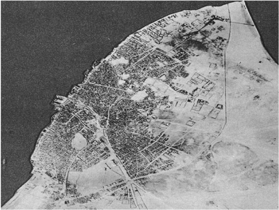
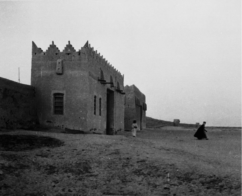
Though they lived in different spatial and social worlds before oil, regular and close interaction occurred between Kuwait's townspeople, Bedouin, and villagers that “blurred the divisions” between them.Footnote 13 Trade relations were strong, and the land- and sea-based economies were intrinsically linked. Bedouin traders often pitched their tents in the open space beyond the town market when they came to trade and buy supplies, creating a tribal “suburb” just outside the urban limits.Footnote 14 By the early 20th century up to 90 percent of Kuwait's pearling fleet consisted of Bedouin divers and sailors.Footnote 15 During the pearling season from May to September, the tribes’ women and children were settled in large camps on the edge of Kuwait Town to be protected by the ruler and townspeople in the men's absence.Footnote 16 Today, however, this interdependence between Kuwait's pre-oil sedentary and nomadic worlds has been replaced with a popular rhetoric that identifies the badū as antagonistic outsiders. The building of a fortified town wall (sūr) in 1920 has become emblematic of this supposed conflict between town and desert. It is commonly, though inaccurately, assumed that the sūr's original purpose was to protect the townspeople on the inside from hostile tribes on the outside. In reality, the wall was built in the summer of 1920 to safeguard the town from an impending attack by the puritanical Ikhwan forces of the Najdi ruler ʿAbd al-ʿAziz ibn Saʿud—with whom Kuwait's ruler Salim al-Sabah was in conflict—who had begun attacking tribes within Kuwaiti territory.Footnote 17 In October the Ikhwan clashed with Salim's forces in a bloody battle in the agricultural village of Jahra, though Kuwait Town itself was never attacked.Footnote 18 The sūr—extending in a rough semi-circle behind the town with five gates—was Kuwait's first fortified defense that “completely [shut] off the city from the landward side” (see Figure 1 and Figure 2).Footnote 19
The pre-oil town with the sūr (photo taken 1950). From Planning and Urban Development in Kuwait (Kuwait: Kuwait Municipality, 1980), 11. Courtesy of the Kuwait Municipality Master Planning Department.

One of the gates. Courtesy of the Kuwait Oil Company archives.
Despite the clear and present Ikhwan threat that prompted its construction, present-day commentators suggest that the wall was built to deflect the danger of the desert more generally, reinventing the sūr as a divisive barrier between ḥaḍar and badū. For instance, a Kuwait News Agency article on the history of the sūr published on 21 February 2009 mentions only that the wall was constructed to ward off enemy attacks (li-darʿ hajāmāt al-aʿdāʾ).Footnote 20 Similarly, a children's book entitled The Wall of Kuwait by Yaʿqub al-Ghunaim (published in English and Arabic) claims that the wall was built to protect the town “against raiders.”Footnote 21 Neither source refers to the Ikhwan or the battle of Jahra; al-Ghunaim simply says that “Kuwait faced some threats that year” and the wall was built to “[prevent] any aggression from reaching the capital and [ensure] security for all residents.”Footnote 22 These accounts evoke the image of an ambiguous and constant menace against the townspeople from outside Bedouin “raiders,” rather than the immediate and finite threat posed by the Ikhwan. Sources produced at the time, by contrast, reflect the sudden urgency that went into the wall's construction in late May 1920: though the British high commissioner assured Salim of air and naval assistance in the event of an assault on the town, the ruler did not allow the pearling fleet to leave that summer so the men could build the wall before the Ikhwan had a chance to attack.Footnote 23
Recent accounts also fail to mention that when the wall was constructed, a large open space was retained between the wall and the town limits so that “friendly tribesmen, with their herds, may obtain protection there from raiding Bedouins.”Footnote 24 On the day of the battle of Jahra the American missionary doctor Stanley Mylrea observed that “refugees from Jahra and the desert were pouring in at the gate, whole families with their household effects.”Footnote 25 British gunboats stationed at either end of the sūr had been instructed to shoot anyone they saw approaching the town, so a group of Bedouin camped nearby was brought inside the gates to avoid being accidentally fired upon.Footnote 26 The wall was thus a source of mutual protection against the Ikhwan for tribes, villagers, and townspeople alike, rather than simply protecting those on the “inside” from those on the “outside.” Though the wall separated town from desert, its gates were situated on existing roads leading to the main villages like Jahra and Fahaheel and to the known caravan routes, thus maintaining (and reflecting) their historical interdependence.
STATE-BUILDING, CITIZENSHIP, AND THE HOMOGENEITY OF THE WHOLE
Despite this history, perceptions of the badū today remain similar to those expressed by Saif al-Shamlan in his 1975 memoirs: “the people of the desert—let the truth be said—have had only a slender positive impact on the life of Kuwait. The raids and troubles that have affected Kuwait and Kuwaitis have come from the desert.” It was the townspeople who “formed the foundation of the state,” al-Shamlan continues, thereby alienating the badū from Kuwaiti nationhood.Footnote 27 In 2009, controversial politician Mohammed al-Juwaihel stated on his private television station (aptly called al-Sur) that “true” Kuwaiti citizens consist solely of those families who resided inside the sūr and in villages like Jahra and Fahaheel before oil, making the badū sector of society not “real” Kuwaitis.Footnote 28
The genesis of this ḥaḍar/badū dichotomy can be traced back not to the pre-oil period but rather to the advent of new state-building strategies developed during the early years of rapid change after the launch of the oil industry. Before oil there was, as the British Political Resident put it in 1865, “little Government interference of any kind” in everyday public life.Footnote 29 The rulers were dependent on merchant capital for the town's administration, the financing of public services, and the provision of money and materiel to safeguard Kuwait's independence. In the absence of a state bureaucratic administration, urban Kuwaitis before oil were dependent on their families, firjān (neighborhoods, sing. farīj), and/or merchant patrons, and the Bedouin and villagers on their tribes, for their everyday welfare. With the advent of oil, however, Kuwait's ruler ʿAbd Allah al-Salim launched a massive state-led modernization scheme in 1950 that rapidly put the government at the center of every Kuwaiti citizen's life and welfare. The institution of Kuwaiti citizenship was key to this state-building project, and to maintaining the stability of the new state. The creation of a singular Kuwaiti national community through citizenship subordinated to the nation-state previous loyalties to farīj, sect, family, or tribe. As a citizen, regardless of socioeconomic status, occupation, or ethnic background, each Kuwaiti (in theory) had equal access to new privileges such as healthcare, education, food, employment, land, and housing. All Kuwaitis thus became dependent on the state for their wellbeing, and the merging of citizenship and state welfare served to homogenize the Kuwaiti population into a manageable, dependent, and loyal whole.
And yet this homogenizing process did not eliminate the social category of “badū,” as Freeth believed would occur. This was partly due to the nature of the country's nationality law. The first attempt at defining the requirements for Kuwaiti nationality was made in 1948, two years after the launch of the oil industry. Residents whose ancestors had been in Kuwait since 1899 were defined as citizens, as were children born in Kuwait to non-Kuwaitis, while Arabs or Muslims living there for up to ten years could apply for citizenship.Footnote 30 However, Kuwait's first census in 1957 revealed that foreigners flocking to the country for work opportunities already constituted 45 percent of the population.Footnote 31 A more restrictive nationality law was therefore passed in 1959 that removed the options of citizenship by birthright or long-term residence. The law defined Kuwaitis “originally” (asāsan) as those persons whose families were “settled in Kuwait” (al-mutawaṭṭinūn fī al-kuwayt) by 1920.Footnote 32 The only option for people who did not meet these requirements to be naturalized as Kuwaiti was by decree from the minister of interior.
The authorities attempted to identify and register Kuwaiti citizens for the first time in preparation for independence in 1961, and all people who considered themselves Kuwaiti had to apply to special committees during fixed enrollment periods to prove their status. The townspeople could furnish adequate documentation—land deeds, birth and death certificates, travel documents—as proof of settlement in Kuwait by 1920. The tribes that grazed and camped beyond the sūr, however, were not permanently settled and did not possess such documentary evidence. About one-third of the Kuwaiti population (not counting recently arriving foreigners with nationality papers from other countries) was recognized as qualifying for “original” citizenship and classified as Kuwaitis bi-l-taʾsīs, meaning “by establishment” or founding. These were predominantly town-dwellers and some villagers. Another third, consisting mainly of members of Bedouin tribes who had not been permanently settled in Kuwait Town before oil,
either because [they] failed to understand the importance of citizenship or, given their centuries-old nomadic way of life, demurred at the idea of belonging to any one country, or because they were living outside the city walls, in the desert or ‘badiya,’ and often illiterate, they could not furnish adequate proof that they were settled in the country . . . were consequently classified as stateless.Footnote 33
These stateless people were designated as “without citizenship” or bidūn jinsiyya (more commonly known simply as bidūn).
The remaining third of the population occupied a more ambiguous category. These were individuals or families who did not meet the legal requirements for citizenship bi-l-taʾsīs but were naturalized as citizens by ministerial decree.Footnote 34 Though some villagers and Arab expatriates were part of this group, the majority were badū granted citizenship in exchange for joining the army (particularly after the attempt of Iraq's ruler ʿAbd al-Karim Qasim to annex Kuwait in 1961).Footnote 35 Those Kuwaitis who became citizens through naturalization (bi-l-tajnīs) were classified differently from citizens bi-l-taʾsīs (who carry jinsiyya ūla or “first-level citizenship”). While members of the two categories held equal rights to employment, land ownership, and welfare benefits, naturalized citizens could not vote or run for parliament until thirty years after their naturalization.Footnote 36
The 1959 nationality law thus created fixed categories of Kuwaiti citizens in relation to time of settlement. The term bi-l-taʾsīs emphasized the difference between “original” and “newcomer” that has become such a prominent part of the ḥaḍar/badū discourse in Kuwait. Those who were settled by 1920—the townspeople and, to some extent, the villagers—were fixed as original Kuwaitis by law. Those who were not settled, even if naturalized as Kuwaitis, were inherently newcomers regardless of their historic ties to or length of residence in Kuwait. The changing of the cut-off date for Kuwaiti nationality bi-l-taʾsīs from 1899 (in the 1948 law) to 1920 (in the 1959 law) further emphasized the law's privileging of the urban: 1920 was popularly known as sanat al-jahra (the year of Jahra, referring to the Ikhwan's assault on the village that October) and closely associated with the building of the wall.Footnote 37 In a sense, then, by fixing 1920 as the new foundation upon which Kuwaiti nationality became based, the law constituted the sūr as the socio-spatial boundary for original Kuwaiti identity (rather than, for instance, the national borders drawn in 1922). This explains why the sūr remains, in Longva's words, “a powerful trope in the discursive construction of hadhar identity.” As she notes, urban Kuwaitis rarely refer to themselves as ḥaḍar and more commonly express their collective identity against the badū as simply “Kuwaitis” or as ahl al-sūr, people inside the wall.Footnote 38
The new nationality law was passed in the wake of the 1950s Arab nationalist movement that gained much popular support in Kuwait. Kuwait's nationalists—who were primarily from the urban middle class—aligned their Pan-Arab agenda with demands for social and political reforms at home. When one of their leaders, Jassim al-Qatami, called for the end of “tribal family rule” (al-ḥukm al-ʿashāʾirī) at a public rally in 1959 (a barely veiled attack against the Al Sabah), ʿAbd Allah al-Salim banned all nationalist activities for two years.Footnote 39 It was in this context that the 1959 law supplanted the 1948 law. The new law distanced Kuwaitis from potentially contaminating Arab expatriates—who began to outnumber Kuwaitis during this early oil period of rapid modernization and increased immigration—by denying the latter the right to apply for citizenship. It also created a singular and exclusive national community to replace all other loyalties, including Arab nationalism. This may explain the law's privileging of the townspeople, the group the state most needed to appease in this era of regional unrest.Footnote 40
Whatever the intentions, the nationality law's emphasis on origin played a significant role in fixing the badū as newcomers. This was exacerbated by developments after 1967 when, in exchange for electoral loyalty to counter the nationalist opposition in parliament, the government began granting citizenship by decree to tens of thousands of nonlocal badū, mostly from Saudi Arabia.Footnote 41 Most were given jinsiyya ūla so they could vote and bolster progovernment forces in the legislature. Despite obtaining full citizenship, the language of the nationality law kept these “new immigrants” permanently outside the contours of what it means (legally and discursively) to be Kuwaiti.Footnote 42 Nor were they fully integrated into Kuwaiti society in practice, as will be seen below, which further reinforced their status as “outsiders.” Also, the granting of citizenship bi-l-taʾsīs to people who were not original to Kuwait (though they were to the deserts of the region) confounded the notions of origin first created by the 1959 nationality law and created myriad tensions. First, it fostered ḥaḍar perceptions of the badū as newcomers and a sociopolitical threat to their own identity. Second, it shifted the meaning of the term badū, which in Kuwaiti discourse now focuses almost entirely on this group. As Longva demonstrates, whereas ḥaḍar “designates Kuwaitis whose forefathers lived in Kuwait before the launch of the oil era (1946),” the term badū “designates a specific group of newcomers: these are immigrants, mostly from Saudi Arabia, who used to live on animal pastoralism; they moved to Kuwait between 1960 and 1980 . . . and have been granted Kuwaiti nationality over the years since then.”Footnote 43 Whereas the village residents tend to be identified as ḥaḍar, the Bedouin tribes who were historically recognized as being tied to Kuwait do not fit in either social category in present-day discourse. Many of these badū, who had “[fallen] through the cracks” of the 1959 nationality law,Footnote 44 became “resentful at the inclusion of recently settled badu among first-category citizens when so many of their own number have been denied that status.”Footnote 45 In addition to being excluded from present-day perceptions of “original” Kuwaitis despite their long-standing history with the place, as well as from the category of badū (which focuses on the “new immigrant” tribes), those who became stateless or bidūn are also often excluded from popular perceptions of that social category. There is a misconception in Kuwaiti discourse today that the stateless or bidūn are people who came from somewhere else (Syria, Jordan, Iraq) and destroyed their original nationality papers. Though such groups certainly exist within the stateless population, a substantial proportion consists of local badū who were never granted citizenship.Footnote 46 As such, these long-standing tribes are entirely misplaced in popular perceptions and definitions of the various social groups that exist in Kuwait today.
While recognizing that terms like ḥaḍar and badū have little analytical validity today as the vast majority of Kuwaitis are settled urbanites who live similar lifestyles, the terms are used throughout this article to designate the following socially constructed categories, based on nationality policies. While ḥaḍar relates to the people who had been settled in the town and villages before oil, badū relates to all tribes who had not been permanently settled in Kuwait Town or the villages prior to the advent of the oil industry in 1946, and who are now Kuwaiti citizens (bi-l-taʾsīs and bi-l-tajnīs). In my use of the term badū I include both the tribes closely associated with Kuwait who began settling in shantytowns from the 1940s onwards, as well as those brought in by the state from Saudi Arabia beginning in the late 1960s for political purposes. This combined group, it is believed, now constitutes around 60 percent of the Kuwaiti national population, though the Kuwaiti census does not give specific information based on such social designations.Footnote 47 As the main focus of the remainder of this article is on state housing policies, I do not include in my use of the term badū the tribes historically associated with Kuwait who became and remain bidūn. The stateless people do not have access to state welfare schemes nor do they possess political rights; they therefore fall outside the scope of this article's main arguments. In Kuwaiti popular discourse, the word qabāʾil (tribes) is used when referring to the badū as a political faction, and is therefore also used below in relation to political opposition, though the terms refer to the same social sector.
STATE HOUSING POLICY AND THE SEGREGATION OF THE PARTS
While the advent of the nationality law created a binary distinction between citizens and noncitizens, the restrictive requirements of the 1959 law coupled with the state's controversial naturalization policies contributed to the creation of two distinct categories of citizens: originals versus newcomers. State welfare also played a key role in this process. Though welfare services including education, healthcare, and housing were provided to all citizens in law, in reality stark inequalities in benefits accorded to the former townspeople and the sedentarizing badū fostered perceptions of these as mutually exclusive groups rather than unifying them as equal Kuwaiti citizens. There is a conceptual distinction between nationality and citizenship in Kuwait. While nationality is defined by law and conferred at the age of eighteen in a nationality document or jinsiyya, citizenship (one's status as a member of the Kuwaiti national community) is largely associated with the access to state welfare benefits that comes with this nationality.Footnote 48 Ali Madanipour argues that social integration largely revolves around access to equitable resources; restricted access to such resources fosters exclusion.Footnote 49 Furthermore, “Many of these forms of access have clear spatial manifestations, as space is the site in which these different forms of access are made possible or denied.”Footnote 50 State housing policies implemented from the 1950s to the 1980s, which spatially segregated sectors of Kuwaiti society and explicitly differentiated between them in styles and standards, relegated the badū to an inferior status as citizens. Such policies are arguably the most important factor in answering Longva's question as to why ḥaḍar and badū still exist as mutually exclusive and oppositional social categories in Kuwait.
“The distribution of land and government-built houses,” Longva argues, “does not take into consideration the recipient's background and thus is leading to a gradual lowering of social barriers in the newer residential areas.”Footnote 51 Though this may be said of state housing policies today, when such policies were introduced in the early 1950s they were designed precisely according to the recipient's background. With the advent of oil, housing became the primary method of wealth distribution and the most important state benefit promising to improve the living standards of Kuwaitis. Moving the population into modern accommodations was also a principal component of the government's new urban development plans. The 1952 master plan required the relocation of the townspeople out of the old town so that the city center could be redeveloped. In the 1960s, plans were made to develop villages like Jahra and Salmiya and to move their inhabitants into modern housing, while the sedentarizing badū were also to be permanently settled. The government did not develop one state-wide housing scheme equally and simultaneously applicable to all these groups, but rather developed three separate schemes that not only kept them segregated but also contributed to fixing them as socio-spatially distinct categories.
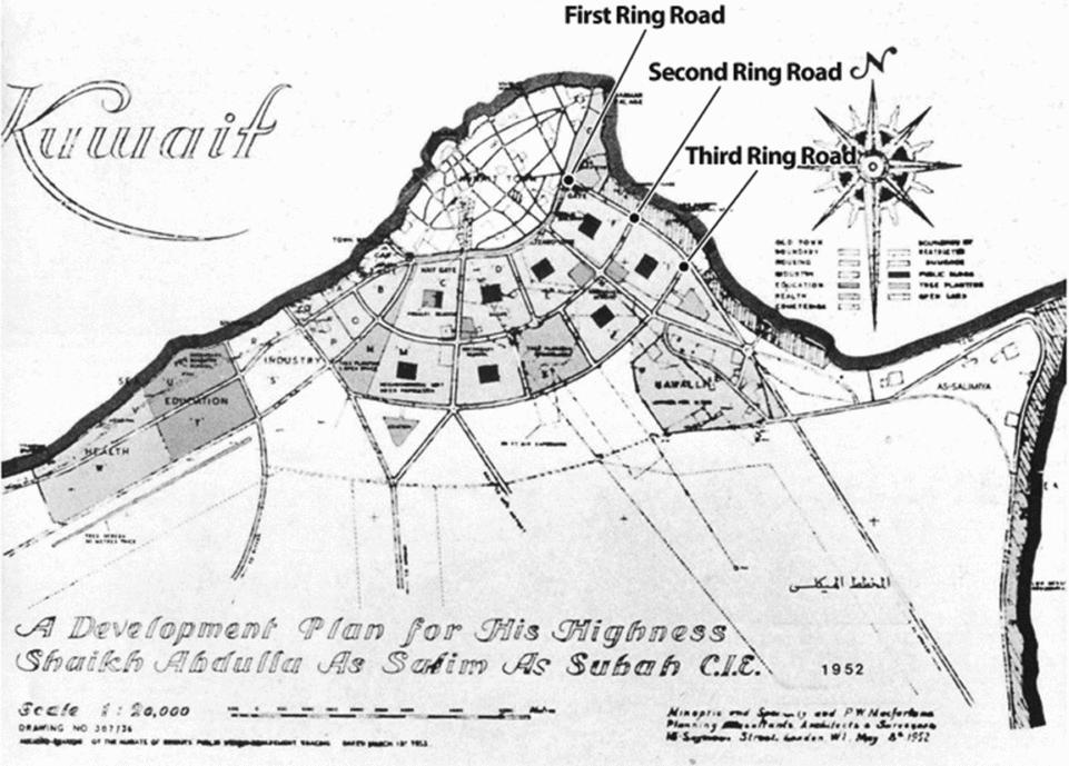
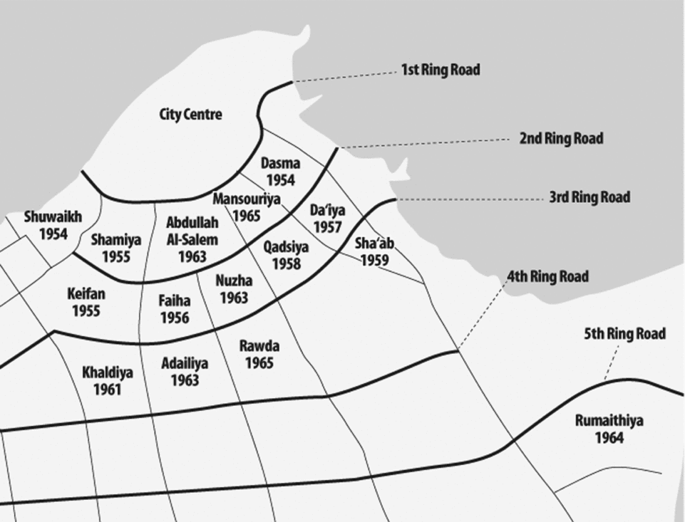
The townspeople were targeted first. The state-commissioned master plan for Kuwait City, designed by a British town planning firm in 1952, designated the space of the old town as a commercial and government center that needed to become more accommodating to cars. The old clusters of courtyard houses were demolished, and new suburbs were constructed just outside the wall to re-house the displaced townspeople. A new ring and radial road system was created; the First Ring Road was constructed just outside and parallel to the semi-circular path of the sūr (demolished in 1957), and the additional rings mimicked its shape as they emanated away from the urban center.Footnote 52 The five gates were physically preserved and it was from these points that the radial roads connecting the ring roads extended. The sūr thus served as the basis of Kuwait's now familiar highway system, which established the boundaries of the new residential suburbs. Eight suburbs were constructed within three ring roads in the 1950s; in 1960 a fourth ring was added and seven additional neighborhoods were built by 1968. These fifteen suburbs became known in official and popular discourse as al-manāṭiq al-numūdhajiyya or the “model areas” (see Figure 3 and Figure 4).
The 1952 Master Plan. Adapted from Stephen Gardiner, Kuwait: The Making of a City (Essex: Longman Group Ltd., 1983), 41. Courtesy of the Kuwait Municipality Master Planning Department.
Al-manāṭiq al-numūdhajiyya between the First and Fourth Ring Roads. Courtesy of Patrick Semaan.
To facilitate the relocation of urban families, the government established a land acquisition scheme (tathmīn al-araḍī) in 1951 whereby land inside the sūr was purchased from the townspeople at deliberately inflated prices, to be used for public or commercial development. The state viewed tathmīn as the quickest form of oil revenue distribution, and it was the principal form of wealth accumulation for most urban Kuwaitis after oil.Footnote 53 It also helped accelerate “an almost wholesale exodus” to the suburbs.Footnote 54 Three housing options were made available to the townspeople in the new suburbs, depending on income: they could obtain a plot of residential land on which to build their home, a plot in conjunction with an interest-free thirty-year loan to build, or a government-built “limited-income group” (LIG) house.Footnote 55
In 1964 a new scheme was developed for re-housing the residents of the villages of Salmiya, Jahra, Farwaniya, and the southern coastal Adan district who had obtained Kuwaiti nationality. Like the townspeople, citizens in these villages whose property was acquired by the state were entitled to a plot of land or LIG housing. However, whereas the townspeople were relocated to new suburbs between the First and Fourth Ring Roads, the villagers could only procure new housing in the same village in which their previous property had been acquired, limiting their ability to move to the more central urban areas (see Figure 5).Footnote 56
The villages. Courtesy of Patrick Semaan.
The only group without access to tathmīn income was the badū, who from the late 1940s began settling in spontaneous shanty settlements. Most of these badū had worked in the now-collapsed pearling industry and began working as laborers in the oil sector or in the country's new army and police forces. The shantytowns also attracted low-income expatriate laborers who could not afford to pay rent elsewhere. Originally, they were located in close proximity to the residents’ place of employment: Maqwaʿ and Waraʾ served the oil center of Ahmadi, Jleeb Al-Shuyukh served the industrial center of Shuwaikh,Footnote 57 and Shamiya (just beyond the sūr) served the city. However, “when Kuwait found a new sense of its own self-importance” during the 1950s, the shantytowns near the city center “were considered degrading to the town's modern image.”Footnote 58 By the 1960s they had all been moved far away from the city and the new suburbs.
In 1965 there were 11,659 shanty homes, made out of palm thatching, wood, and corrugated iron. By 1970, Colin Buchanan and Partners (CBP, the British firm that designed Kuwait's second master plan) estimated that the number had doubled to around 20,400. The shanty population rose from 64,800 in 1965 to 113,400 in 1970. CBP estimated that about 80 percent of these were Kuwaitis.Footnote 59 The reports claim that the reason for the doubling of shanty-dwellers was the inflow of badū who had been settled and granted citizenship in these years, “partly for reasons of political stability.”Footnote 60 They estimated that some 70,000 shanty dwellers were from this group.Footnote 61
Freeth described the shanties she saw in 1970 as having “an air of depressing squalor.”Footnote 62 Their residents had “fallen through the sieve of the welfare state” and worked in the lowest-paying jobs.Footnote 63 Most men in the shantytowns earned salaries of around 40 to 60 Kuwaiti dinars per month. Though many of the residents were Kuwaiti nationals or bidūn employed in the military, and thus legally eligible for state housing, until the early 1970s few measures were taken to re-house them in state-provided accommodation. Many shanty-dwellers began petitioning the Ministry of Social Affairs and Labor for new housing in the mid-1960s, to no avail.Footnote 64 The townspeople had been moved out of the city because the government needed the space to implement the 1952 master plan; the shanty areas lay well beyond the planned urban development area in the 1950s and 1960s, and so remained outside the immediate sphere of state concern.
That is not to say that nothing was done in the 1960s to solve the shanty problem. After independence in 1961, Kuwait began positioning itself to take up “a distinct position alongside the civilised and developed world states,”Footnote 65 and the presence of these “aesthetic blotches on the landscape”Footnote 66 did not align with its nahḍa al-ʿumrāniyya (architectural awakening).Footnote 67 Between 1962 and 1968 around 1,400 LIG homes were therefore allocated for taḥḍīr al-badū (badū settlement) in new areas like Omariya, Sabahiya, and Badawiya.Footnote 68 But it was not until 1970, with the significant growth of the shanty population, that the government, in conjunction with the CBP planners, began to seriously plan for the re-housing of Kuwaiti shanty residents (though foreign and bidūn residents were not part of this scheme).
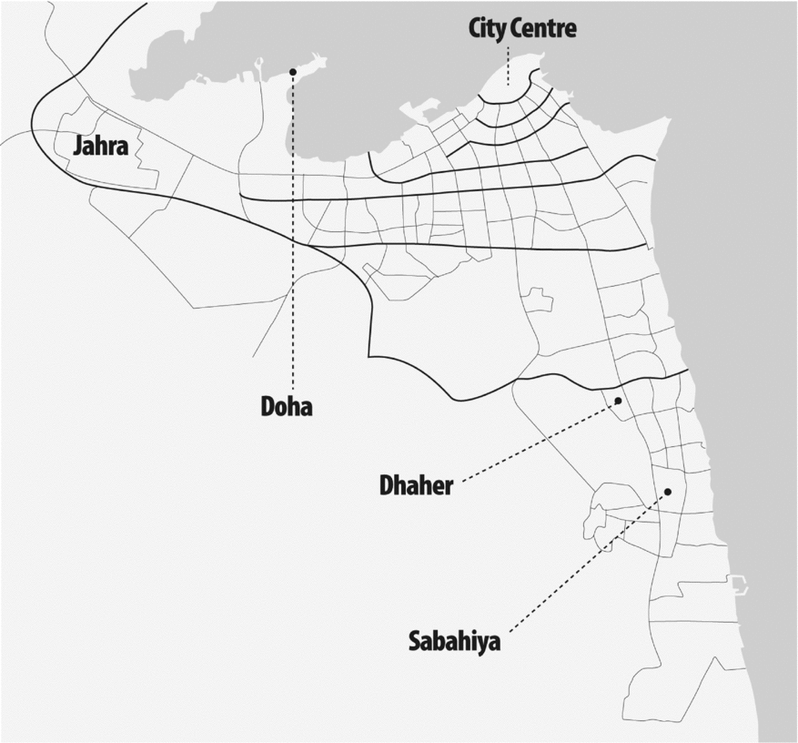
The objective of this mashruʿ al-bādiya (desert project)Footnote 69 was not just to provide better housing and services to Kuwaiti citizens living in appalling conditions but also to facilitate “as smooth a transition as possible from tribal life to urban life.”Footnote 70 A staging process for badū settlement was therefore adopted. First, in the early 1970s the many scattered and spontaneously built shantytowns were consolidated into three large settlements in Shadadiya, Sayhad, and Doha as a temporary solution.Footnote 71 These government-designated shanty areas were bound by high-wire perimeter fences, giving them “the rather forbidding aspect of a concentration camp.”Footnote 72 The next step was to move shanty residents into temporary housing known as shaʿbiyya or “popular” housing in areas like Sulaibiya, Jleeb al-Shuyukh, and Jahra. Though more solid than shanties, shaʿbiyya houses were constructed very cheaply, using locally made gray concrete bricks without any plastering, painting, or other finishing applied, and the settlement areas contained no paved roads, “just the sandy surface of the desert.”Footnote 73 By the mid-1970s, plans were made for more permanent large-scale Bedouin LIG housing projects in areas like Mina Abdullah, Jahra, and ʿArdhiya, and private international firms were commissioned to finance, design, and build a “completely new suburbia in the desert.”Footnote 74 Most residents of the shaʿbiyya areas like Sulaibiya were eventually transferred to these new projects. The shaʿbiyya houses were then populated by bidūn shanty-dwellers not eligible for state housing, who remain there today.
Despite claims to be introducing the badū to al-ḥayāt al-ḥaḍariyya or settled urban life,Footnote 75 this complex process kept the badū in a state of impermanence well into the 1980s. Though the original shantytowns were successfully consolidated into three main areas, families were often forced to move from one new settlement to another. For instance, in 1978 6,000 families in Shadadiya (forced to move there from another shantytown three years earlier) had to move to Sayhad due to the planning of a new national park nearby.Footnote 76 Nor did things improve once the badū moved out of the new settlements into shaʿbiyya housing. In 1979, families arriving in Sulaibiya found that the area still had no electricity. By summer the brick houses became so hot that the residents moved into tents (buyūt shaʿar) in the desert.Footnote 77 Many families also moved back into buyūt shaʿar after the municipality demolished 16,000 shanties en masse in 1978 before sufficient replacement housing was prepared. According to Khalaf Madlul, “In the beginning we lived in shanties in Doha, then were moved to Sayhad, then to Shadadiya, and then when they were demolished we had no choice but to start over in a tent.”Footnote 78 By 1982 new spontaneous shanty settlements had emerged again on the outskirts of Jahra.Footnote 79
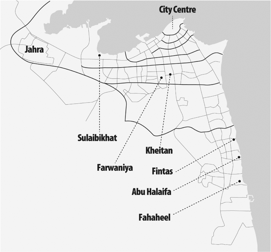
The purported aim of the badū settlement program was to integrate the tribes into “Kuwait's urbanized society” (mujtamaʿ al-kuwayt al-mutaḥaḍir).Footnote 80 In reality, it fostered the exclusion of the badū from that society, making many feel as though they were “cut off from everything but the grace of God.”Footnote 81 The most noteworthy aspect of all the taḥḍīr al-badū settlement schemes was the distance between these areas and the city center (see Figure 6). Rather than incorporating these projects within the new residential districts between the First and Fourth Ring Roads, the government constructed separate areas well beyond the Fifth and Sixth Ring Roads.Footnote 82 These areas were cut off from the city and from al-manāṭiq al-numūdhajiyya. Large-scale shanty camps like Shadadiya had no paved access roads, though residents regularly asked that roads be built to “link us to Kuwait City.”Footnote 83 The desert path leading to and from Shadadiya was riddled with nails and construction debris, and the high risk of tire damage prohibited buses, taxis, and even ambulances from getting to the settlement.Footnote 84 Things did not improve in the new large-scale LIG housing projects. When Sabahiya was built, for instance, once again no access roads were prepared and residents without cars had to walk across two kilometers of desert before reaching the highway to catch a ride to work.Footnote 85
Some of the outlying badū settlement areas. Courtesy of Patrick Semaan.
The justification for locating their areas far away from the city was that badū needed easy access to open desert for grazing and also had “the emotional need to be in an environment which is not completely cut off from the desert open spaces.”Footnote 86 The viability of this argument is questionable, however, as many badū who were allocated houses in outlying areas like Riqqa, Omariya, and Sabahiya in the early 1970s rejected them due to the distance from the urban center where they worked (exacerbated by the lack of sufficient roads).Footnote 87 The Undersecretary of Social Affairs and Labor admitted in 1971 that the majority of applicants for government housing, including badū, specified the city as their preferred residence. The fact that at the peak of the new settlement scheme “the number of people rejecting their new houses outnumbered the people applying for a new house”Footnote 88 calls into question the notion that the badū had “special needs” that required them to be settled in distant areas.Footnote 89 After all, the urbanization of the badū was nothing new to Kuwait; historically “the transition from badu to hadhar [was] . . . the very condition for its existence.”Footnote 90 In 1963 a Maqwaʿ resident demanded that if the government was not going to give him and his fellow shanty-dwellers houses they should at least be allowed to build their shanties closer to the city, like the earliest settlement in Shamiya.Footnote 91 Since the 1940s the badū had been drawn toward the city, but state housing policies pushed them back out to the desert.
This segregation contributed to fixing ḥaḍar and badū as mutually exclusive, and spatially bounded, social categories. In contrast to al-manāṭiq al-numūdhajiyya, the areas created for badū settlement were known in official discourse as al-manāṭiq al-khārijiyya or the “outlying areas.” As Longva argues, “In naming the badu areas in terms that remind of their original status as outsiders, the state contributes to keeping alive the perception of difference between hadhar and badu and the battery of cultural images that goes with it.”Footnote 92 Dividing these two worlds were the country's ring roads—the Third by the end of the fifties, the Fourth by the end of the sixties, and the Fifth by the early eighties—encircling the neighborhoods that were “undisputedly ‘hadhar.’” By 2006, Longva determined that “the concrete dividing line between the two social worlds is generally considered to be the Sixth,” beyond which lies “‘badu territory.’”Footnote 93 The fact that the sūr served as the basis of Kuwait's ring road system inadvertently adds to its association as a symbolic barrier dividing two different and seemingly incompatible social worlds.
Contributing to the isolation of the new LIG housing estates for badū settlement was the fact that, because they were situated “beyond the so-called planning limits of the city,”Footnote 94 they were designed to be self-contained with full shopping facilities, community and leisure centers, government offices, schools, clinics, and police stations.Footnote 95 The plan was to obviate the need for their residents to commute to commercial or service centers within the Kuwait City metropolitan area, thereby reducing traffic congestion in the urban center.Footnote 96 While al-manāṭiq al-numūdhajiyya also contained neighborhood co-operative centers with a supermarket, pharmacy, clinic, and police station, as well as their own schools, their residents still relied on the city center and commercial districts like Salmiya for leisure, shopping, and other services. The spatial distance between al-manāṭiq al-numūdhajiyya and al-manāṭiq al-khārijiyya prevented much social mixing between their residents. Though many badū held low-paying clerical positions in government bureaucracies where many ḥaḍar also worked (albeit usually in higher positions), this contact was insufficient to foster integration. Ash Amin and Nigel Thrift argue that cultural hybridization requires meaningful and repeated contact: the slow experience of working, living, and playing with others.Footnote 97 However, ḥaḍar and badū were not experiencing much meaningful and repeated contact outside the workplace that could create deeper social ties between them. As an article in the local newspaper al-Raʾi al-ʿAmm explained in 1978, “The workplace in Kuwait creates an environment that combines different social groups, but since these groups have nothing in common with each other there is no mixing or social integration. Under these circumstances, the social adaptation of the badū in society is slow due to restricted social relations.”Footnote 98
In addition to their spatial isolation, the badū settlements also received significantly inferior state-provided services. Most significant was the size and quality of housing. Residential plots inside the Fourth Ring Road—where the average family size in 1970 was seven people—were between 400 and 750 square meters for government-built houses, and 750 and 1,000 square meters for self-built homes; all were detached villas with ample space for gardens and garages.Footnote 99 A shaʿbiyya house, by contrast, was only fifty square meters with two or three bedrooms and a small living room, though the average badū family size was fifteen.Footnote 100 Even in the new housing estates like Sabahiya, plots were normally only 150 square meters and walls were shared between neighbors in attached row houses.Footnote 101
Free education and healthcare, like housing, are critical pillars of the state welfare system to which Kuwaiti citizens have access. However, the residents of the badū settlement areas did not have sufficient access to these services until the late 1980s. Entrance into public schools and district clinics was based on residential area. When they lived in shantytowns they were not registered in any district and could therefore only go to government hospitals in the city and, because they had no legal registered address, were forced to pay.Footnote 102 “We are told that medical care is a right of all citizens,” said one Maqwaʿ resident in 1965, “but we are denied access as if we weren't citizens.”Footnote 103 Things only slightly improved after they moved into their permanent housing estates. In 1971, Sabahiya's clinic consisted of a single small room for an area that by 1970 contained 866 households.Footnote 104 There were no schools, and children who were able to attend school in the village of Abu Halaifa had to wake up very early in the morning to make it on time.Footnote 105 Throughout the 1960s and 1970s the badū residents of these areas demanded access to the same modern services that Kuwaitis living in the inner suburbs were getting: education in modern schools, proper healthcare, water and electricity, permanent housing, and parks and libraries for their children.Footnote 106
The stark disparities in housing and public services between the inner and outer districts, social geographer Abdulrasool al-Moosa argues, imposed “severe social barriers inside the Kuwaiti community.”Footnote 107 As a 1971 newspaper article on Sabahiya put it: “The face of Kuwait is what we witness in the luxurious houses and villas . . . of those with envied incomes; its bowels are the houses of those with limited incomes.”Footnote 108 This reality created feelings of superiority among the former vis-à-vis the latter. In a 1982 housing survey, al-Moosa questioned urban Kuwaitis on the desirability of mixing all nationals together in the same residential districts regardless of wealth or social origin. One third of respondents strongly resisted integration, and another third remained apprehensive. Al-Moosa's respondents considered residents of the new LIG housing projects “as inferiors and [treated] them accordingly, a factor that makes integration more difficult.”Footnote 109 The latter, meanwhile, as expressed in another newspaper article in 1971, found it increasingly “hard to believe that they live in a country with a three billion dinar budget and in the same country as the residents of the [inner] suburbs.”Footnote 110 Many felt excluded from full integration into Kuwaiti society despite being lawful and equal citizens. Residents of the Maqwaʿ shantytown in 1965 insisted that they had built and defended Kuwait, “yet here we are living a life of misery and poverty. They don't grant us our rights or listen to us.”Footnote 111 Their long history of association with Kuwait was regularly cited in newspaper articles on the plight of the shanty-dwellers. “My father, grandfather, grandfather's grandfather were all born in Kuwait,” Khalaf Madlul from Sulaibiyya stated in 1979, “and we don't have anywhere else.”Footnote 112
Residents of the former villages felt a similar sense of exclusion. As a 1979 newspaper article on Egaila, a coastal village south of Kuwait City, stated:
Kuwait is witnessing an awakening in different architectural and administrative fields . . . [with] whole cities being built using the most up-to-date techniques, where citizens are offered all the services needed to implement the government's policy of creating a society built on equality and luxury. And yet there are still areas that lack such services and facilities, [whose residents] are demanding the bare minimum to foster an equal living standard between them and the other modern areas, so that citizens don't feel a gap between what is available to others and what they are deprived of.Footnote 113
Egaila's residents were still waiting for their old traditional houses to be acquired by the government with compensation so the area could be properly planned, and new government housing provided. Most houses were dilapidated and on the verge of collapse. With a population of 3,000, the area contained no schools, supermarkets, police stations, paved roads, municipal services, or medical facilities. According to Humud al-Sahli, “It's as if the people living in Egaila are not sons of Kuwait . . . Where is the equality that all citizens in all areas should be entitled to?”Footnote 114 Thus, while today ḥaḍar like the politician Mohammed al-Juwaihel consider the village residents “real” Kuwaitis, they themselves felt excluded from the privileged status of the townspeople.
By the early 1980s, most mudbrick houses, tents, and shanties had been removed from Kuwait's modern landscape, and the task of re-housing all citizens in new residential districts with the country's newfound oil income was complete. In 1984 the National Housing Authority standardized the options available for all subsequent housing applicants, whereby residential plots and government-built houses were allocated in integrated areas that no longer differentiated citizens by income bracket or background.Footnote 115 However, the economic slump of the 1980s coupled with the Iraqi invasion of 1990 and its aftermath meant that such standardized government housing did not start to be allocated to newly applying citizens until the late 1990s. New residential districts developed between the Fifth and Seventh Ring Roads over the past fifteen years are more socially integrated than the older manāṭiq al-numūdhajiyya and manāṭiq al-khārijiyya. Furthermore, the residents of the latter now have better access to education and other social services, and improved road networks mean they are no longer spatially cut off from the main metropolitan areas. Nonetheless, the stigma of their long-term spatial isolation and distance from the city center continues to differentiate the badū in Kuwaiti society despite these changes.
This stigma is poignantly reflected in the 2007 film Sharq, written by a group of young ḥaḍar men. The film is about six “small-town Kuwaiti boys” from Jahra who decide to venture into “the sprawling metropolis of Kuwait City” to buy a new soccer ball.Footnote 116 The film begins with boys playing soccer barefoot in the desert with no sign of nearby buildings or roads. Kuwait City is a place they point to on the horizon but which none of the boys has ever visited because, as one of them puts it, “we are at the end of the world.” They walk across the empty desert (complete with shots of camels to emphasize their badū identity) back to their quiet Jahra neighborhood of run-down shaʿbiyya housing to steal their father's pick-up truck (another stereotypical badū trademark). During the drive, the boys speak mockingly about “them” (the city-dwellers) and their lifestyle. When they finally reach the city the Jahra boys are exposed to an exciting new world: busy markets, highways, expensive cars, grand villas, high-rise buildings, and luxurious shopping malls. After a long day they end up playing soccer in the grass by the sea with a group of urban boys. In making the two groups of boys get along despite their supposed cultural differences, the filmmakers suggest that such differences can be easily overcome with greater contact and social mixing. Despite this message, and though ostensibly a sympathetic depiction of badū experiences, the film encompasses the us/them discourse that shapes the ḥaḍar/badū dichotomy today, both in the boys’ conversation and in the film's depiction of the badū in their isolated, simple, and mundane world far from the bright lights of Sharq.
OPPOSITIONAL POLITICS
The spatial isolation of the badū, though resulting in their social marginalization, contributed to the government's strategy of using the tribes to stabilize the existing political paradigm and therefore facilitated their political integration. Prior to the 1981 elections, after parliament had been unconstitutionally suspended for five years, the ruler Jabir al-Ahmad changed the number of voting districts in Kuwait from ten (with five MPs per district) to twenty-five (with two representatives each). Most of the new districts were the outlying badū settlement areas that had been established after the original ten districts were drawn in 1963.Footnote 117 This redistricting guaranteed badū representation in parliament, where the government could then buy their legislative votes. The state's turn to the badū as key allies against urban opposition forces was made evident during the so-called dīwaniyya movement of 1989. Every Monday for seven weeks, a public gathering was held in the private dīwaniyya (majlis) of a member of the defunct parliament unconstitutionally dissolved in 1986, to discuss the restoration of the constitution. The government tolerated these gatherings when held in the inner suburbs. But when the fifth meeting was planned at a parliamentarian's home in Jahra, the National Guard used direct force against the thousands of attendees. Youssef al-Mubaraki attributes these extreme measures to the fact that the gathering was in a progovernment stronghold, putting its residents at risk of political contamination.Footnote 118
However, while the state's spatial policies to keep the badū segregated was key to maintaining a political balance between loyal and oppositional forces, the fact that the badū were not only spatially isolated but also socially excluded through inferior benefits and services made it difficult to maintain their long-term loyalty. According to Ghabra, as younger generations of badū became better educated, they realized they had been serving the needs of the political system at the expense of their own needs and rights, and therefore remained socially weaker than, despite the fact that were starting to outnumber, the ḥaḍar.Footnote 119 As Kuwaiti writer Mohammed al-Jassim put it in 2006: “The ḥaḍar bemoan that ‘we have become the minority,’ while the badū say ‘we are the oppressed majority.’”Footnote 120
In 2006, a youth-based campaign to curb electoral corruption and vote buying successfully led to the reduction of electoral districts from twenty-five to five. With ten representatives now elected per district and with the fourth and fifth districts constituting the predominantly badū “outlying areas,” tribal representation in parliament increased in the May 2008 elections, with the qabāʾil winning twenty-three out of the fifty seats.Footnote 121 The fourth and fifth districts contained 38 percent of the national population (with more than half a million citizens in the fifth alone), and 54 percent of registered voters in 2008.Footnote 122 The fact that the tribal deputies now represented such sizeable populations made it difficult for the government to buy them out, as MPs began listening to their constituencies instead.Footnote 123 This resulted in numerous interpellations of cabinet ministers (popularly known as grillings) by tribal MPs; in 2007, for instance, Minister of Health Maʿsuma al-Mubarak was grilled for a fire that broke out in Jahra's only hospital, killing two patients.
Whereas Longva's ḥaḍar informants criticized the badū for their “purported blind obedience toward the power holders” and claimed that “a critical attitude toward the government” was an important ḥaḍar attribute,Footnote 124 today the tribes (aligned with the Islamists) have become the principal opposition to the government. A full exploration of the current political standoff between the government and the tribal-Islamic opposition is beyond the scope of this article, but it is important to identify the conflict's impact on the ḥaḍar/badū dichotomy. Though most tribal opposition leaders, such as Musallam al-Barrak (the most prominent and contentious current challenger to the Al Sabah), do not explicitly articulate badū inequalities as part of their political agenda, decades of exclusion, marginalization, and inequality help explain why their badū constituents support them. But this is something that many ḥaḍar find difficult to grasp. A 2009 blog post entitled “Kuwait is not just for the badū,” by a young ḥaḍar man under the pseudonym “Frankom,” is a case in point.Footnote 125 The post was in response to a controversy over an accidental fire in a wedding hall in Jahra that killed two people. When residents demanded that someone from government be held accountable, as the hall had no fire extinguishers and emergency rescue services took too long to arrive on the scene, the district's MP immediately called for the grilling of the minister of health. Frankom characterized such reactions as “racist” and “divisive” on the part of the badū; he claimed that hundreds of accidents happened every day in Kuwait, but only “when something happens to them over there” do the badū react “like they are God's chosen people.” By interpreting their reactions to the fire (which occurred a year after the Jahra hospital fire) as a sign of self-importance, Frankom failed to critically grasp why residents of a neglected and underprivileged area like Jahra might react politically to such an accident.
The recent political empowerment of the tribes has increased ḥaḍar perceptions of the badū as newcomers and an encroaching threat. As one commentator wrote on Frankom's blog post:
[W]henever I watch old TV shows . . . or see pictures of old Kuwait . . . or the names of former parliament members . . . I wonder, where were these people who now cause all the problems in the city and in parliament? . . . The families of [Kuwait Town] are known, the families of Jahra are known, the families of Fahaheel are known, and that was all of Kuwait. So did these others just pop out of the desert from nothing, like truffles?
As already mentioned, a similar statement was made by parliamentary candidate Mohammed al-Juwaihel in 2009 when he said that only families who lived inside the town wall and in the villages before oil are real Kuwaitis. A year later al-Juwaihel was beaten unconscious at a political rally by tribal followers of his political adversary al-Barrak.Footnote 126 This did not deter him from verbally insulting another candidate, Obayd al-Wasmi, and his Mutair tribe in campaign speeches during the February 2012 parliamentary elections, leading to the burning down of al-Juwaihel's campaign tent by Mutairi tribesmen.Footnote 127 That al-Juwaihel was one of only a few nontribal and non-Islamist candidates to be elected to the February 2012 parliament signifies that many Kuwaitis agree with his “aggressively intolerant rhetoric.”Footnote 128
And yet, though ḥaḍar rhetoric branding the badū as a threat to Kuwaiti social and political culture remains alive and well, there are signs that it is becoming less palatable. One example is the public outcry against Shaykha Fariha al-Sabah, the amir's sister, in January 2013. Over the previous two months, thousands of demonstrators of all backgrounds had been protesting the amir's controversial November decree that reduced the number of votes per citizen from four to one. Shayhka Fariha described the protestors as lafu (a derogatory slang word for newly naturalized citizens) and “not Kuwaiti.” The uproar in the press and social media, from ḥaḍar and badū alike, was considerable. Large numbers of citizens flocked to their local police stations, including in some of the inner suburbs such as Nuzha and Faiha, to file official complaints against her. Her statements were described as uneducated, insulting to the Kuwaiti people, and harmful to the social fabric, particularly coming from an Al Sabah.Footnote 129
CONCLUSION
In 2007 Frankom wrote that: “Kuwait is ḥaḍar and badū . . . Kuwait is for all of us.” Though seemingly inclusive, this sentiment actually recognizes the existence of these as mutually exclusive groups; in fact, he also wrote that people who say there are no differences between ḥaḍar and badū in Kuwait should wake up to reality. But since the escalation of political tensions in more recent years, and perhaps in response to the heightened anti-badū polemics expressed by people like al-Juwaihel and Shaykha Fariha, a new discourse is slowly emerging among younger figures on both sides. It is becoming more common in social media to hear sentiments like those expressed by the journalist ʿAbd al-Muhsin al-Mishari in July 2012, in which he appealed to his fellow Kuwaitis to stand together for the sake of the country's future: “No majority or minority, no ḥaḍar or badū, no Sunni or Shiʿi. We are all Kuwaitis fighting against disorder.”Footnote 130 This newly emerging though still nascent discourse that seeks to eliminate the ḥaḍar/badū dichotomy—a dichotomy with little analytical validity in Kuwait today given that most ḥaḍar have tribal lineage and all badū are now urbanized—has arguably come about precisely because the badū have become such a vocal and visible opposition force. Once the badū stopped engaging in “obsequious hand kissing” of the power-holders, as Longva put it, the ḥaḍar not only had to contend with the badū infringing on their historic status as Kuwait's leading political opposition.Footnote 131 They also have had to come to terms with the fact that those still labeled as “badū” now constitute the demographic majority and can no longer be marginalized. In a 2010 article unpacking ḥaḍar/badū relations, journalist Ahmad al-Mudaf called for a reconceptualization of Kuwaiti citizenship to be more inclusive for all members of society, but without erasing the differences that exist between them. He suggested a heterogeneous but shared Kuwaiti nationality through which markers of difference—which are neither erased nor excluded but retained as sub-identities—become less antagonistic.Footnote 132
The objective of this article has been to build on Longva's analysis of the ḥaḍar/badū dichotomy by filling in the historical gap to reveal the various factors that have contributed to its persistence—especially naturalization, housing, and electoral policies implemented in the first three decades of oil. Furthermore, analyzing developments in ḥaḍar/badū relations over the eight years since her article was published is necessary not only to understand how and why the badū have become so oppositional today, but also to highlight the subtle changes emerging in the discourse that have the potential to finally eliminate this contentious dichotomy.