Introduction
Twenty years of archaeological survey and fieldwork in the territory and suburbs of Lepcis Magna have given us a unique opportunity to observe the development of the landscape through both peace and war. The survey project of the Archaeological Mission of Roma Tre University in Libya, initiated in 1995, was not targeted to a specific historical period but conceived to understand patterns and trends of settlement since the earliest forms of human presence up to contemporary times. In the same manner, our approach to the issue of the preservation of the cultural heritage will retain a diachronic character, focusing the narrative on the long term.
We intend to describe the events and attitudes toward the cultural landscape of rural Tripolitania, following the changes from the beginning of the twentieth century, when Italy initiated a colonial war for the conquest of Libya, to the troubled present.
Paul Bennett and Graeme Barker (Reference Bennett and Barker2011) have presented the fragile situation regarding the cultural heritage in Libya – especially in Cyrenaica – just before the Revolution broke out in 2011. From that year onwards, due to the unstable political situation, the archaeological landscape is even more at risk. The case study of the territory of Lepcis Magna shows how this area, already looted and damaged in the last century, is currently suffering from a serious lack of control and protection.
1. Italo-Turkish War and World War I
During the Italo-Turkish conflict (1911–12) and in the following years (1913–23), in order to build military structures urgently, the opposing armies used or destroyed ancient mausolea, villas and gsur, especially along and around the defensive lines that were designed by the Regio Esercito (Royal Italian Army) from the city of Khoms to the eastern suburb of Lepcis Magna (see IGM 1913).
Khoms and Lebda remained an isolated Italian bridgehead in a region outside colonial control until 1923, when the reconquest of Tripolitania began with the occupation of Misurata Marina. Both the military and construction activities of the Regio Esercito often came across finds and ancient structures in the rich Lepcitanian archaeological suburban landscape. For the Army the archaeological remains represented a resource rather than a problem, both for propaganda reasons (when important finds were discovered by soldiers) and through the practice of reusing ancient structures or their limestone ashlar blocks, very useful for quickly building the new military fortifications.
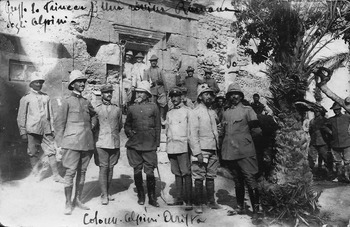
In the first years of the Italian administration, at Khoms – north-west of Lepcis – for example, two mausolea were reused for military purposes by the 82nd Regiment (Mondovì) of the Alpini Corps (Figure 1; see Matoug Reference Matoug1997, 214, pl. 90b; Munzi et al. Reference Munzi, Cirelli, Felici and Zocchi2013, 20, fig. 9), and another mausoleum on the western outskirts of the city known as Gasr el-Fituri was reused by the Italian troops to build a strongpoint (Aurigemma Reference Aurigemma1925, 11; Cesàro Reference Cesàro1933, 48; IGM 1913; Sjöström Reference Sjöström1993, 132 nr. 6).
Italian Alpini posing in front of a mausoleum at Khoms, 1912 (A. Zocchi, personal archive).

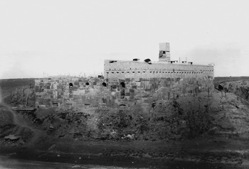
Also the south and eastern suburbs of Lepcis were affected by battles and skirmishes and by the construction of military structures. In particular, the ancient earthen bank of the Monticelli with the necropolis around it as well as different ruins were disturbed, damaged or even destroyed by hasty excavations, related to the construction of military roads, trenches, redoubts and strongholds (Aurigemma Reference Aurigemma1929, 246–47; Reference Aurigemma1930, 76, 84; Romanelli Reference Romanelli1925a, 63). An emblematic example is that of the Wadi Lebda fort, built above a Roman cistern, at that time one of the highest and most visible structures south of the ancient city (Figure 2; see Romanelli Reference Romanelli1925a, 143–44; Reference Romanelli1925b, 215–16).
Italian ‘Uadi Lebda’ (Wadi Lebda) fort set on the Roman cistern south of Lepcis Magna, 1912–13 (Courtesy of Giovanni Marieni Saredo).

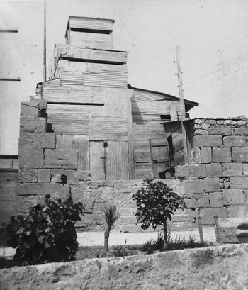
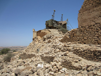
The events concerning Ras el-Mergheb are also typical: the strategic hilltop, overlooking Khoms and the road towards Tripoli, was the theatre of three battles between October 1911 and March 1912. Once conquered, the Roman ruins which stood there were transformed into a fort (Forte Italia) by the Italian Army (Munzi et al. Reference Munzi, Cirelli, Felici and Zocchi2013, 21–24). Part of the ancient structures on the hilltop, such as a monumental arch, are still in situ while a quadrangular gasr built with limestone ashlar blocks was reused by the Italian Army and in part obliterated (Figure 3; see I. Sjöström in Munzi et al. Reference Munzi, Felici, Sjöström and Zocchi2014, 230–32; Reference Munzi, Dridi and Mezzolani Andreose2016, 74–76).
Ashlar structures of the gasr of Ras el-Mergheb (KHM 108) reused by the Italian Army, 1913 (A. Zocchi, personal archive).

On the other hand, we should also remember that, thanks to the military activities and to the personal interest of the soldiers towards the antiquities, important documents were published related to Lepcis and its adjacent suburbium. This is the case of the accurate map Lebda (Lepcis Magna) realised by the two topographers Enrico Grupelli and Randolfo Alessandrini of the Istituto Geografico Militare in 1915 and the valuable account entitled Lebda nel Maggio 1912, published by the lieutenant Francesco Stroppa (Reference Stroppa1912).
Archaeological evidence of the battlefields, military reuse of farms and mausolea, was also identified by our surveys in the area between Ras al-Mergheb and Ras el-Hammam (Munzi et al. Reference Munzi, Cirelli, Felici and Zocchi2013; cfr. part 4, infra).
2. World War II
Some thirty years later, Libya became one of major theatres of World War II. However, if Cyrenaica was seriously affected, Tripolitania was largely spared the ravages of war.
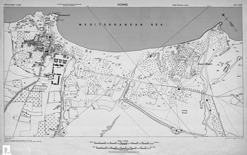
While in a context of general risk and even if some Italian troops were scattered in light fortifications around Khoms and Lepcis (Figure 4), the ancient city and its suburb were not seriously disturbed, except for the frequent visits of soldiers in their free time. The areas most affected by military installations seem to be those close to the main roads. Furthermore, particularly sensitive from a military point of view was the landing area built during the 1920s between Via Balbia and the Monticelli agger, a few hundred metres south of the Severan Arch. Both the levelling carried out during its construction and its use may have caused disturbance to this portion of land so close to the ancient urban fabric.
Plan of the city of Khoms and Lepcis Magna, 1943 (US Army Map Service, 1:5,000 scale).

The defences around Ras el-Mergheb realised by the Regio Esercito were extended and improved. An aerial photograph taken by the Royal Air Force in 1942 and stored at the National Archives in London (TNA, War Office, 234–84) shows the area equipped with several military observation posts on the hills both north and south of the road that led from Khoms to Cussabat. In the same aerial photographs an anti-tank ditch is clearly visible, running all around the Ras el-Mergheb hill (well documented in USACE 1962). This ditch, partially identified by our survey (cfr. part 4), may have caused serious damage – due to its length and depth – to the numerous archaeological sites in the area.
During the war the Italian Soprintendenza, with lorries supplied by the Army, saved the mobile archaeological heritage, moving it away from the combat areas and sending part of it to Italy. The task was accomplished mainly by Gennaro Pesce, the deputy superintendent left in Libya during the Italo-German retreat and the Allied occupation.
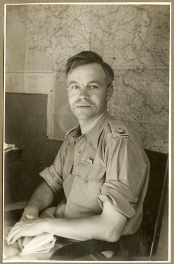
When the Eighth Army arrived in Tripolitania in January 1943, Mortimer Wheeler and John Bryan Ward-Perkins (Figure 5) were serving in it. Once in Lepcis Magna, the two officers (and archaeologists) found that a unit of the Royal Air Force was about to build a radio station among the ruins (252 AMES). Thanks to their intervention the station was established elsewhere (Munzi Reference Munzi2012, 97–99; Reference Munzi, Dridi and Mezzolani Andreose2016, 97–100).
John Bryan Ward-Perkins (1943–45; Courtesy of BSR Photographic Archive and the Ward-Perkins family).

The Italian landing ground south of Lepcis was immediately (February 1943) put back in operation by the Allies; this was at the time considered a military target by German reconnaissance aircrafts,Footnote 1 probably together with a radar station (275 AMES: TNA, AIR 29-175) and units camped near the Wadi Lebda, south of Lepcis Magna.Footnote 2 Luckily there was no bombing, the war in Libya being de facto at an end. British and Allied soldiers could spend their leisure time visiting sites and museums, and archaeological guides were written for them, but it was impossible to avoid some minor losses. Ward-Perkins meticulously records these in his reports, preserved in the National Archives in London.
In the memorandum dated August 1943 addressed to Mr Edward Warner (political officer of the British Embassy to the Greek government-in-exile in Cairo), Major Ward-Perkins described the situation of Lepcis Magna as soon as he visited the ancient ruins a few days after the Eighth Army had entered Khoms:
The initial damage was heaviest on this site, whence all the staff had been withdrawn on the approach of the British Forces, and could not be reinstated before 29 January. The museum was broken into, but except for two vases deliberately smashed, damage was confined to the looting of offices and stores. […] All stores and magazines throughout the area of excavations were broken open and the contents scattered by British Troops who signed their names. In some cases however, the initial looting was the work of local Arabs, who organised a raid on a cache of archaeological material, known only to the Italian staff and to their native workmen, which had been placed in the vaults of the Roman Theatre and sealed with heavy masonry. In addition two statues were overturned and damaged, a marble capital thrown down onto the marble seat of the ancient public lavatory, smashing it, and many names were written, and in some cases carved, on various monuments. (TNA, Foreign Office, 371/37330/1)
Further damage was reported in the period between February and May 1943: two marble columns were smashed and a statue overturned in the Severan Forum, a magazine in the Old Forum was partially looted and several decorations on a frieze of the Severan Arch were mutilated. However, the main concern of Ward-Perkins appears to have been the lack of proper safeguards in the ancient city, especially on the occasion of concerts performed at the Roman Theatre during those months, when some 4,000 troops passed through the ruins, often after dusk and without any supervision.
Before the end of the war new finds around Lepcis Magna were also registered by the British military administration. In his account entitled ‘Reports on Tripolitania and Cyrenaica war damage to monuments’ addressed to Mr James Mann (Wallace Collection, London), Brigadier Mortimer Wheeler mentioned the discovery in 1943 of a ‘suburban villa three miles east of Lepcis with mosaic pavements and unusually complete wall-paintings’ and the site ‘of a pottery kiln six miles west of Homs’ (TNA, T 209-19).Footnote 3
3. Kingdom of Libya and Jamahiriya
After WWII, and especially after the 1960s, the archaeological landscape around Lepcis Magna suffered intense overbuilding. The main reason of this urbanisation was the expansion of the city of Khoms, whose eastern built-up areas have almost reached the ancient city walls. Moreover, both the Suk el-Khamis–Khoms motorway and the Misurata–Tripoli highway have enabled in the last decades the spread of new houses and also the birth of several industrial and commercial buildings along their paths. Recently, the unfinished railroad that is intended to link the modern Khoms harbour with Misurata has also cut through wide portions of ancient landscape.
The population growth of the last seventy years and the consequent need for infrastructures unavoidably and immediately clashed with the heritage preservation of the area. For instance, several hypogean tombs were found during the first years of the fifties during the building of the ‘British Officers’ Club’ barracks at a short distance from Wadi er-Rsaf (c. 700 m north-west from Lepcis Magna's Late Antique wall) and during the construction of other structures between the Severan arch and the Suk el-Khamis–Khoms motorway (Vergara Caffarelli Reference Vergara Caffarelli1953; Reference Vergara Caffarelli1954). From the sixties onwards, the local Department of Antiquities (DoA) was often involved in the monitoring of new building developments. A significant example is the excavation of numerous hypogea in the 1970s during the construction of a hospital in the same location as the British barracks, west of Wadi er-Rsaf. In those years other cemeteries were discovered and partially investigated on the occasion of different rescue excavations in the suburban areas of Lepcis Magna (D. Baldoni in Musso et al. Reference Musso, Baldoni, Bianchi, Calì, Davidde, Di Vita-Evrard, Munzi, Petriaggi, Pinna Caboni, Ponti and Shebani2010, 60–61).
Several ancient sites were also explored or just noted by the DoA, often in the course of emergency rescue excavations: for instance, at the end of the 1970s, the construction of a power plant and a desalter, c. 4 km south-east of Lepcis and a short distance from the seashore, revealed the presence of a Roman villa. This lavish coastal residence, equipped with painted plaster and mosaics and opus sectile floors, was only partially excavated and scantily documented before its demolition (L. Musso and B. Bianchi in Musso et al. Reference Musso, Baldoni, Bianchi, Cilla, Di Vita-Evrard, Felici, Fontana, Mallegni, Masturzo, Munzi and Usai1998, 186, 216–18). Another modern infrastructure that has heavily modified the landscape was the building of the new harbour of Khoms, located c. 5 km north-west of Lepcis Magna. During the construction activities in 2000 of the related facilities the DoA, together with a team of the University of Roma Tre Archaeological Mission, surveyed the area, noticing the presence of several ancient villas and mausolea just a few months before they were destroyed.Footnote 4 Unfortunately, many other areas around Lepcis Magna and Khoms were urbanised without any archaeological inspection, leaving unanswered questions and uncertainties relating to wide portions of the ancient suburban landscape, above all the outskirts of Khoms and the flat area south-east of Lepcis, now densely urbanised with fenced private properties.
The pharaonic works of digging a canal to carry the fossil waters of the Sahara to the coastal cities (Gheddafi's Great Man-made River) also caused great losses to the Tripolitanian cultural landscape. Our surveys of the Bendar basin (1995) and of the Silin area (1996–97) both came across the artificial channel and its ancillary building activities, and the consequent destruction of rural archaeological sites.
4. The archaeological survey of the Lepcitanian suburbs (2007–13)
The recent survey of the area behind Lepcis Magna and Khoms carried out by the Archaeological Mission of Roma Tre University in 2007, 2009 and 2013 (Munzi et al. Reference Munzi, Felici, Cirelli, Schingo, Zocchi, Milanese, Ruggeri and Vismara2010; Reference Munzi, Cirelli, Felici and Zocchi2013; Reference Munzi, Felici, Sjöström and Zocchi2014; Reference Munzi, Felici, Matoug, Sjöström and Zocchi2016; Musso et al. Reference Musso, Baldoni, Baroni, Bessi, Bianchi, Bruno, Buccino, Davidde Petriaggi, Felici, al-Hadad, Munzi, Petriaggi, Shebani, Sjöström and Zocchi2013–2014, 28–38) has allowed us to register and better understand the type and extent of damage to the cultural heritage from the Italo-Turkish War through to the present day (2016). In the course of three survey campaigns 168 sites have been recorded, from the Punico-Numidian to the Ottoman period. At each site the land use at the time of the visit was also documented and, if appropriate, any damage or modern disturbance. Moreover, the possibility of comparing this information with the latest satellite images available on Google Earth has enabled us to determine any further damage or destruction at the sites in recent years.
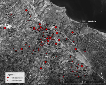
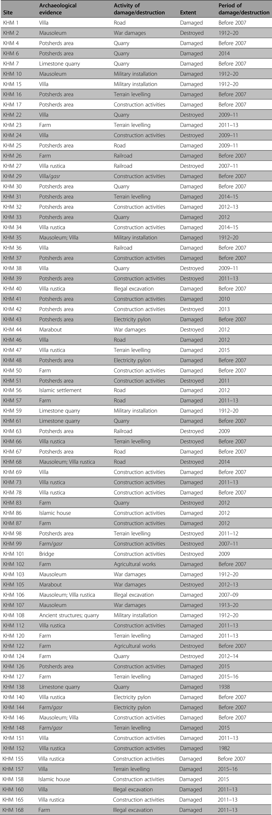
Out of a total of 168 sites, 78 (46.4%) have been damaged or destroyed in little more than a century; of these 78 sites, 19 (11.3% of the total) were completely destroyed for varying reasons (see Table 1 and Figure 6). However, we have to consider that these percentages would increase if we were to take into account that many other sites in the same area were not registered within the Lepcitanian survey, because they were already heavily damaged or destroyed and were therefore not visible.
Sites of the archaeological survey behind Lepcis Magna and Khoms (2007–13) damaged or destroyed (Background image: Google Earth).

Sites documented by the Lepcitanian survey that have been damaged or destroyed since 1911–12.

4.1. Causes of damage/destruction
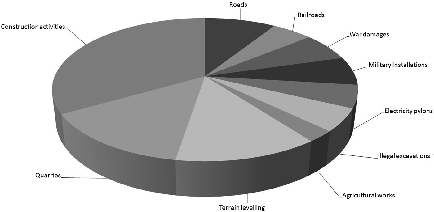
Observing the major causes of damage/destruction (Figure 7) it seems clear that the main one is related to the recent building activities. Indeed, the percentage of this type of damage (33.3%), together with other disturbances almost always related to the exploitation of building material or to creating space for quarries (14.1%) and terrain levelling (12.8%), comfortably exceeds half of the total, reaching 60.2%. Damage or destruction was also caused by the building of infrastructures like roads (8.9%), railroads (5.1%), electricity pylons (5.1%) and military installations related to the forts and strongholds of the colonial period (6.4%). The total percentage caused by these ‘government’ infrastructures exceeds a quarter of the total (25.5%).
Lepcitanian survey: causes of the damage/destruction of the sites.

Five sites (6.4%) were instead damaged or destroyed by clashes during the Italo-Turkish War or caused by the recent unstable political and religious situation. In both cases a conflict, armed or ideological, is the cause of these heritage losses. Four sites in the survey area (5.1%) were found to have been disturbed by illegal excavations often made with excavators, a detail that leads us to think that this damage may have occurred in association with building activities.
Finally, minor disturbances seem to be related to purely agricultural activities (2.5%). The reasons of this low percentage could be explained both by the type of cultivation and by their location. Indeed, the majority of the survey area that is not urbanised is used for pasture or left uncultivated, while most of the cultivated areas are occupied by olive trees: both these factors have favoured the preservation of the topsoil. Furthermore, most of the cultivated areas are located along the wadi beds that usually are not occupied by ancient settlements.
4.2. Periods of damage/destruction
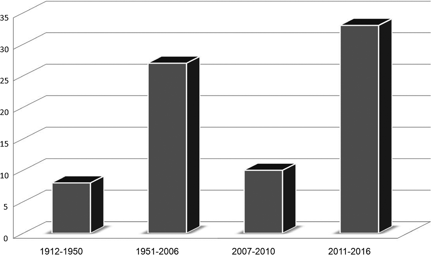
The damage/destruction related to the survey's sites can be divided into four principal periods, from the Italo-Turkish/Libyan War until the ongoing conflict (Figure 8). The previous phases (related to the damage occurred in the Karamanli and Ottoman periods) are not included in this discussion even if the reuse of building material from ancient sites – and the resulting damage – must also have been a common practice in those centuries. For instance, almost certainly, the capitals, the column bases and shafts and the numerous ashlar blocks reused in the eighteenth/nineteenth-century Ras el-Hammam mosque (Figure 6, KHM 105) were looted from the nearby villa and mausolea (KHM 106) or from the adjacent Gasr el-Hammam (A. Zocchi in Munzi et al. Reference Munzi, Felici, Sjöström and Zocchi2014, 236). The seeking out and reuse of ancient material from the Lepcitanian suburban sites to build or restore mosques, marabouts and government buildings in Khoms and its surroundings were recorded up to the end of the Ottoman period (Aurigemma Reference Aurigemma1914, 473; Lothringen 1874, 165–67).
Lepcitanian survey: number of sites damaged or destroyed divided in periods from 1912 to 2016.

Out of a total of 78 sites, eight (10.2%) were damaged or destroyed during the Italo-Turkish War (1911–12) and during the subsequent phase of the Italian military deployment to keep the area safe against the rebel uprisings (1913–23). However, it is plausible to hypothesise that further damages or losses – currently impossible to detect – occurred in archaeological areas close to the Italian defensive line from Lebda to Khoms, where numerous ridotte (redoubts) and forts were built.
In the following years (1923–50), associated with the colonial and WWII periods, the main damage caused to the archaeological landscape in the survey area seems to have been brought about by the construction of the Italian anti-tank ditch around the Ras el-Mergheb hill (cfr. part 2).
In the period between 1951 and 2006 (the year before the beginning of the suburban survey) the percentage of damaged/destroyed sites reached one third of the total (34.6%). Unfortunately it is difficult to determine further subdivisions within this long period, essentially due to a scarcity of available sources (aerial photos and satellite imagery). However it seems reasonable to hypothesise that the majority of the damage/losses related to this phase occurred after the 1960s/70s, when Khoms and its hinterland began to expand quickly. Indeed, almost all the damage wrought in this period (96.2%) is related to construction activities.
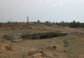
In the four years 2007–10, i.e. between beginning the survey and before the civil war, 10 sites (12.8%) were damaged or destroyed. Also in this case the majority of the disturbances (90%) were related to building activities. One of the main losses in those years was the destruction of the Roman bridge (Figure 6, KHM 101) of the via in Mediterraneum, located a few hundred metres south of Lepcis Magna. Briefly described by Francesco Stroppa (Reference Stroppa1912, 72) and Pietro Romanelli (Reference Romanelli1925a, 73), it was built over the canal realised in the second century AD to divert the Wadi Lebda and prevent flood and siltation damage. The opus caementicium structure, which was still clearly visible in 2007, much as Stroppa and Romanelli saw it (Figure 9), was destroyed in 2009 and the area surrounding it levelled to facilitate the building of houses and commercial activities. The same fate befell large portions of the nearby ancient earthen bank of the Monticelli, as well as the remains of Fort Lebda, now largely demolished.
The bridge (KHM 101) of the Monticelli agger, 2007 (Photo: Archaeological Mission, Roma Tre University).

The heritage losses increased significantly between 2011 and 2016: in six years of political crisis and instability 33 sites out of a total of 78 (42.3%) have been destroyed or damaged. Once again, most of the losses and damage has been caused by uncontrolled overbuilding (88%), now favoured by a substantial decrease in, or even by an absence of, government controls. The other types of devastation have been caused by both Islamic fundamentalists (6%), who seem to have systematically destroyed the ancient marabouts of the area (cfr. part 5), and illegal excavations (6%). The most worrying data related to this period is, however, the overall outrageous increase in the damage or destruction of the archaeological and historical sites of this unique landscape: in only six years 19.6% of the 168 sites recorded in the Lepcitanian survey have been blighted or destroyed.
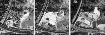
Besides the uncontrolled overbuilding and the activity of religious fundamentalists, these last six years were also characterised by a significant increase in land exploitation to provide the el-Mergheb Cement Factory with gravel and sand. Since it was opened in 1969, the industrial complex (located c. 6 km west of Lepcis Magna) had already consumed a surface of 25 hectares of soil at the time of the survey and destroyed an entire hill named Ras el-Manubia (IGM 1918; 1937).Footnote 5 From 2012 onwards a new area of c. 2 hectares has been added, destroying the remains of a Roman farm together with most of its potsherd area of c. 2,000 sq. m (Figures 6 (KHM 124) and 10).
The site of an ancient farm (KHM 124) destroyed by quarry activities, related to the el-Mergheb Cement Factory, from 2006 to 2016.

5. The disappearance of the marabouts (2011–16)
The unstable political situation in Libya has caused and is still causing noticeable losses to the cultural heritage of Tripolitania. In particular, the territory of Lepcis Magna is suffering on the one hand from the lack of surveillance to monitor new construction activities, on the other from the driven destruction of the marabouts by Islamic fundamentalists, probably – according to witnesses – adhering to the Salafi movement.
Apart from the two main causes of damage mentioned above, it is also appropriate to remember that in the first phase of the Libyan crisis an important site of the territory around Lepcis Magna was directly involved in the war: once again the Roman (and colonial) site on the hilltop of Ras el-Mergheb (Figure 6, KHM 108). Indeed, since the Jamahiriya period the Mergheb hilltop has hosted a military radar station that was bombed by a NATO airstrike during spring/summer 2011 (Figure 11). Luckily, the accuracy of the bombardment was able to target only the military facilities, leaving intact the adjacent Roman arch (I. Sjöström in Munzi et al. Reference Munzi, Felici, Sjöström and Zocchi2014, 230–32; Reference Munzi, Felici, Matoug, Sjöström and Zocchi2016, 75) but damaging the surviving remains of the Italian fort, built reusing part of the ancient structures (see part 1).
Remains of the military radar station at Ras el-Mergheb after the airstrike, 2013 (Photo: Archaeological Mission, Roma Tre University).

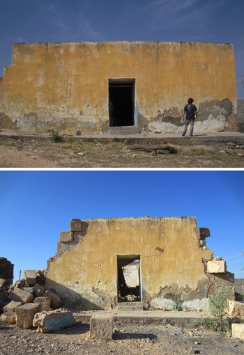
The historical landscape of the Lepcis Magna suburbs suffered two heavy losses in 2012–13. The eighteenth/nineteenth-century Ras el-Hammam mosque (Figure 6, KHM 105), known by the name of al-Saba or Sidi Ahmed el-Gandur (A. Zocchi in Munzi et al. Reference Munzi, Felici, Sjöström and Zocchi2014, 236; Reference Munzi, Felici, Matoug, Sjöström and Zocchi2016, 105) was almost completely demolished in 2012–13 using an excavator, leaving the majority of the ancient building material on the site (Figure 12). This destruction revealed that the mosque/marabout had been restored recently due to the presence of plaster rendering and a concrete roof; however, originally it had been built reusing as part of its main walls the Roman external enclosure of a gasr characterised by limestone ashlar blocks. These ancient walls, already detected by Romanelli and Ward-Perkins, are now partially visible, even if heavily damaged by the excavator (I. Sjöström in Munzi et al. Reference Munzi, Felici, Matoug, Sjöström and Zocchi2016, 98).
The facade of the Ras el-Hammam mosque (KHM 105) in 2009 (top) and 2013 (bottom) (Photo: Archaeological Mission, Roma Tre University).

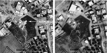
The Sidi Zaid el-Garib marabout (Figure 6, KHM 44; A. Zocchi in Munzi et al. Reference Munzi, Felici, Sjöström and Zocchi2014, 236; Reference Munzi, Felici, Matoug, Sjöström and Zocchi2016, 105–106) was instead completely obliterated, including its peripheral cemetery in 2012 (Figure 13). This monument was built near the village of Leggata (now part the southern outskirts of Khoms) and was mentioned by Sheikh Abdussalam el-Alem el-Tagiuri in the seventeenth century (Cesàro Reference Cesàro1933, 47–48). Its original square plan, with the ribbed gubba (dome) set on an octagonal drum, probably dated to the sixteenth century and it constituted one of the oldest and best-preserved marabouts of the area.
Sidi Zaid el-Garib marabout (KHM 44) before (2011, on the left) and after (2013, on the right) its destruction (Background image: Google Earth).

Unfortunately, destruction in our survey area has not been limited to the main religious structures, but it appears to have also involved the minor rural marabouts. Small structures such Sidi Raquid al-‘Arsah and Sidi al-Gharid (A. Zocchi in Munzi et al. Reference Munzi, Felici, Sjöström and Zocchi2014, 236) were bulldozed between 2012 and 2013.
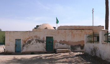
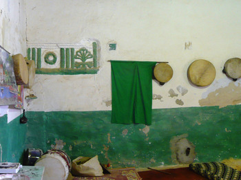
The driven destruction of the marabouts of course goes beyond the survey area: for instance, the seventeenth-century Sidi Azzaz marabout in the Silin area (Munzi et al. Reference Munzi, Felici, Cifani, Cirelli, Gaudiosi, Lucarini and Matug2004, 59, site 63) and the eighteenth-century Sidi Hassen marabout and Coranic school at Suk el-Juma (c. 25 km south-east of Lepcis Magna) have been completely destroyed (Figure 14). In the latter case, together with the demolition of the marabout, several ancient architectural elements reused inside the religious structure were lost, such as a fragment of a Doric frieze (Figure 15), probably related to the large adjacent Roman mausoleum known by the name of Gasr el-Giuma (Bartoccini Reference Bartoccini1926, fig. 41; Merighi Reference Merighi1940, 2, 157–58).
Sidi Hassen marabout and Coranic school at Suk el-Juma before its destruction, 2009 (Photo: Archaeological Mission, Roma Tre University).

The Doric frieze reused inside the Sidi Hassen marabout at Suk el-Juma, 2009 (Photo: Archaeological Mission, Roma Tre University).

6. Concluding remarks
The present analysis, based on twenty years of field experience, allows us to identify constants and variables in the destruction/damage phenomena across the twentieth and twenty-first centuries. In extreme synthesis, two major causes appear, related on the one hand to military activities and on the other to civilian ones.
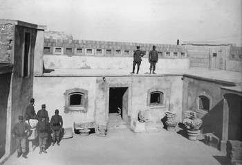
Conflict causes: Colonial wars (1911–23), WWII and the recent civil war have resulted in the reuse, damage and destruction of ancient rural sites. However, we must point out a major variation in the attitudes towards the heritage. In the colonial period the military needs led to substantial destruction of ancient villas-farms, mausolea and infrastructures (for comparison with French North Africa, see Greenhalgh Reference Greenhalgh2014), but at the same time this resulted in partial archaeological documentation by the same military officers or by the archaeologists of the Soprintendenza, also because in the colonial discourse the ‘Roman’ heritage was considered as a fundamental element, promoting the legitimacy of the conquest (Figure 16). By contrast, the recent civil war resulted mainly in a selective and deliberate destruction, ideological and religious in character, targeted against African Sufism. The marabouts – primary elements of the cultural landscape of Tripolitania and more generally of North Africa – have disappeared almost everywhere, targeted for destruction by Salafi fundamentalists. In Tripolitania this is a serious cultural loss, which erases most of the rural religious architecture of the Karamanli/Ottoman age. The destruction of Sufi shrines in Tripolitania is part of a much broader phenomenon which spans from Tunisia to Mali (Desmarais and Eloundou Assomo Reference Desmarais and Eloundou Assomo2013; Prince Reference Prince2013; Reference Prince2015).
Archaeological material collected by the Italian soldiers and stored at ‘Forte Settimio Severo’, eastern Lepcitanian suburb, 1912–13 (Courtesy of Giovanni Marieni Saredo).

Civilian causes: Agricultural, building and industrial activities have impacted constantly on the cultural heritage, particularly since the second half of the twentieth century. The el-Mergheb cement factory, Gheddafi's Great Man-made River and, more generally, the diffuse and uncontrolled development of the town of Khoms, which expanded its periphery without proper urban planning especially since the last years of the Jamahiriya, have deeply and rapidly disfigured the traditional landscape: villas and farms in the hinterland, coastal villas on the Khoms seashore and in the new harbour zone, large sectors of the Monticelli agger were and are still being sacrificed.
Currently the local armed volunteer guards, together with the personnel of the local Department of Antiquities are protecting the site of Lepcis Magna, preventing looting and damage within the UNESCO World Heritage Site (Semgupta Reference Semgupta2015). However, the situation in the nearby territory and hinterland is different and largely out of control. There is a lack of proper information for many other historical Islamic monuments, for example for those on the coastal strip east of Lepcis, which have been surveyed and documented in 1999–2000. In particular there is concern for the mosque and madrasa of Sidi Ali el-Fergiáni, dating back to the sixteenth/seventeenth century, located in the oasis between the centre of Suq al-Khamis and the course of Wadi Caam, known for the numerous reused architectural elements from Lepcis Magna, particularly from Porta Oea (Bianchi Reference Bianchi2009, 63–66; Cirelli et al. Reference Cirelli, Felici, Munzi and Galetti2012, 773). However, the religious building, according to the most recent satellite images available (end of 2016), is still standing and no damage seems to have occurred.
It appears clear that only a return to political stability and consequently to strong central government control will discourage the continued depredation of the cultural heritage.