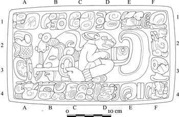
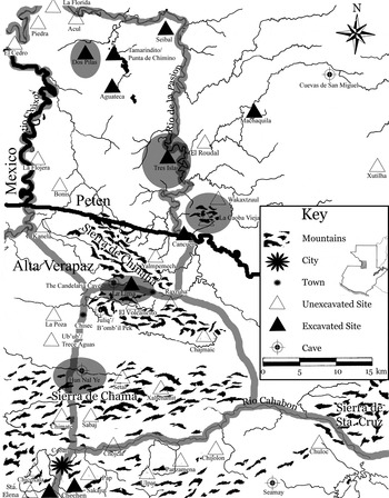
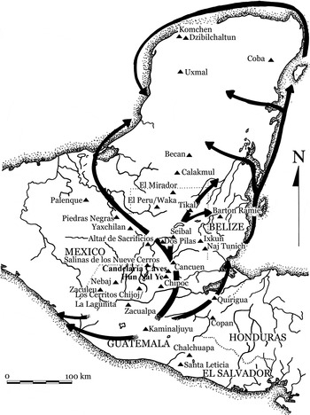
In 2005, a stone coffer (Figure 1) was found in the Cave of Hun Nal Ye, located 20 km north of the modern highland city of Coban (Figure 2) (Woodfill Reference Woodfill2007, Reference Woodfill2010; Woodfill et al. Reference Woodfill, Fahsen, Monterroso, Laporte, Arroyo and Mejía2006). It dates to the Early Classic and although it was found in the northern highlands, it was carved in a strong Tikaleño tradition. The lid depicted a lowland-style deity in low relief ringed by glyphs, while the four sides depicted various gods and artisans, each associated with more glyphic texts.
Stone box lid from the Cave of Hun Nal Ye. Drawing by Luís Luin.

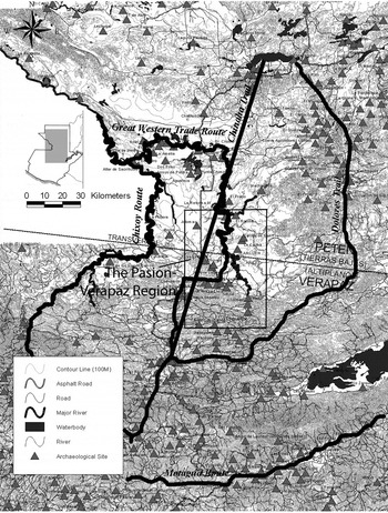
Map of the Pasion-Verapaz Region highlighting caves and sites discussed in this article. The probable location of the Great Western Trade Route is indicated in grey. Drawing by the author (adapted from an original drawing by Walter Burgos).

What was such a box doing deep in a cave in the northern highlands, far from any known centers? To make matters stranger, all of the whole pots with the box were in the styles of various regions further into the highlands—the Verapaz, the Valley of Guatemala, the Salama and Motagua valleys, and southeastern El Salvador.
While our team was originally interested in this cave as a way to explore ancient Maya ritual activity, with the combination of the lowland coffer and the highland vessels, we quickly realized its potential to fill in gaps in the culture history of the region. In the end, this turned out to be but one of many caves that are providing information central to understanding local culture-history and highland-lowland interaction in the Maya world.
This article is based around a single argument: cave archaeology should be taken as seriously as other methodological specialties like epigraphy, household archaeology, and geographical information systems (GIS). After a brief history of cave archaeology and a summary of ways other scholars have used cave assemblages to answer questions outside of the “black box” of religion and ritual I will give several examples showing how cave archaeology has been essential to the reconstruction of culture history, ceramic production, trade routes, and economy at the highland-lowland transition in central Guatemala.
EARLY MESOAMERICAN CAVE ARCHAEOLOGY
Inquiry into Mesoamerican caves has a particularly old pedigree. It began during the early Colonial period when Diego de Landa (Reference Landa and Gates1978 [1566]) noted that the Maya used caves for a variety of ritual activities; this same observation was echoed by missionaries and explorers in the following centuries (Fuentes y Guzman 1957 [1690], Gage Reference Gage and Kahn1928 [1648], Stephens Reference Stephens and Ackerman1993 [1842]). The first report on archaeological investigations in caves in the Maya world was written by Henry Mercer (1975 [1896]) at the end of the nineteenth century, and it was soon followed by E.H. Thompson's (Reference Thompson1897) report on the Cave of Loltun, and Gordon (Reference Gordon1898) and Seler's (Reference Seler and Weeks2003 [1901]) work in caves in opposite ends of the Maya highlands.
In spite of the ethnographic and ethnohistoric evidence to the contrary, each of these nineteenth-century archaeologists treated caves as habitational contexts, ignoring or remaining ambivalent to any potential ritual activity, a trend that persisted for the next 80 years (Andrews Reference Andrews1961, Reference Andrews1965; Healy Reference Healy1974; Joyce Reference Joyce1929; Joyce et al. Reference Joyce, Gann, Gruning and Long1928; Pendergast Reference Pendergast1964, Reference Pendergast1969, Reference Pendergast1971, Reference Pendergast1974; Pope and Sibberenson Reference Pope and Sibberenson1981; see also Ball and Ladd Reference Ball, Ladd, Coggins and Shane1992; Healy Reference Healy2007; Varela Torrecilla and Bonor Villarejo Reference Varela Torrecilla, Juan Luís Bonor, Breton, Becquelin and Ruz2003). The notable exception to this occurred in 1959, when J.E.S. Thompson (Reference Thompson1959) published “The Role of Caves in Maya Culture,” in which he posited that caves were fundamentally ritual places. As a German museum publication with little circulation outside of central Europe the publication had little impact on the field (Brady Reference Brady and Mercer2005a). A modified version of the paper was published shortly before his death (Thompson Reference Thompson and Mercer1975) as the introduction to the reprint of Mercer's report, but again this was mostly overlooked.
THE RITUAL REVOLUTION AND THE PETEXBATUN ARCHAEOLOGICAL CAVE SURVEY
Although there had been several archaeological projects examining caves through the lens of ritual (Carot Reference Carot1976, Reference Carot1987, Reference Carot1989; Heyden Reference Heyden1973, Reference Heyden1975; MacLeod and Puleston Reference MacLeod, Puleston, Robertson and Jeffers1978), James Brady's (Reference Brady1982, 1989; see also Stone Reference Stone1995) investigation of Naj Tunich, Guatemala, was the first long-term, systematic study of a single cave in Mesoamerica. Unlike earlier cave investigations, it combined intensive field research, laboratory analysis, and a comprehensive survey of extant cave literature, and, for the first time, provided conclusive evidence that caves were a central and universal part of Maya cosmovision, not a peripheral phenomenon.
As Brady was finishing up his dissertation, Arthur Demarest (Reference Demarest, Demarest, Houston, Inomata, Escobedo and Palka1990, Reference Demarest2006) was beginning a multi-year and multi-site project in the Petexbatun region. In 1990, project members began discovering caves underneath major architectural complexes at Dos Pilas (Houston Reference Houston, Demarest, Houston, Inomata, Escobedo and Palka1990). After an initial foray into one of the caves, during which Demarest (Reference Demarest1997:218, Reference Demarest2006) found a large quantity of artifacts, fell through a hole in the floor, got lost, and had to be rescued by a small squad of workmen, he realized two things: (1) that a cave subproject would be essential to understanding the history of Dos Pilas; and, (2) that such projects should be the work of specialists. Brady was invited onto the project mid-season, and began investigations almost immediately (Brady Reference Brady, Demarest, Houston, Inomata, Escobedo and Palka1990; Brady et al. Reference Brady, Scott, Cobb, Rodas, Fogarty and Sánchez1997).
Although an earlier regional cave project had been conducted by Bonor Villarejo (Reference Bonor Villarejo1987; Bonor Villarejo and Sanchez y Pinto Reference Bonor Villarejo and Pinto1991), the Petexbatun Archaeological Cave Survey was the first project to systematically study caves in tandem with a larger settlement survey, and several breakthroughs were soon made by collaborations between the two camps. For example, these studies proved that the layout of Dos Pilas was strongly influenced by the placement of caves, with several of the principal structures located above or facing caves (Brady Reference Brady1991; Brady et al. Reference Brady, Scott, Cobb, Rodas, Fogarty and Sánchez1997; Demarest et al. Reference Demarest, Morgan, Wolley, Escobedo and Christie2003), a pattern which Brady has also identified at other sites (Brady Reference Brady1997, Reference Brady, Colas, Delvendahl, Kuhnert and Schubart2000a; Brady and Ashmore Reference Brady, Ashmore, Ashmore and Knapp1999; Brady and Veni Reference Brady and Veni1992). In addition, the project reported that over half of all of the jade recovered by the Petexbatun project (with the exception of a massive funerary cache from Dos Pilas) and between 20% and 50% of most other artifact classes were found in caves (Brady Reference Brady, Laporte and Escobedo1994, Reference Brady, Prufer and Brady2005b). Many of these objects had little evidence of use (or were made of materials that never “wore out,” like jade and pyrite), and Brady (Reference Brady, Laporte and Escobedo1994, Reference Brady, Prufer and Brady2005b) postulated that cave ritual might have functioned as a way to take items out of circulation, necessitating the production of more goods.
While Dos Pilas was the initial focus of the cave investigation, the team proved to be so successful that it expanded into other sites in the region (Brady and Rodas Reference Brady, Rodas, Laporte and Escobedo1994), and was even exported to another project directed by Juan Pedro Laporte in the southeastern Peten (Brady et al. Reference Brady, Cobb, Garza, Burnett and Laporte2003; Garza et al. Reference Garza, Brady and Christensen2001).
Since the Petexbatun Archaeological Cave Survey, a subterranean component has been included in a variety of archaeological projects (Brady Reference Brady1995; Ishihara Reference Ishihara2007; McAnany et al. Reference McAnany, Harrison-Buck and Morandi2004; Peterson Reference Peterson2006; Prufer Reference Prufer2002; Rissolo Reference Rissolo2003). Cave-centric projects (Aguilar et al. Reference Aguilar, Jaen, Tucker, Brady, Brady and Prufer2005; Bassie Reference Bassie2002; Brady Reference Brady2000b, Reference Brady2009; Anda Reference Anda2009; Fitzsimmons Reference Fitzsimmons, Brady and Prufer2005; Patel Reference Patel, Prufer and Brady2005; Tucker et al. Reference Tucker, Garcia, Jaen and Brady2006) have been undertaken in all corners of Mesoamerica, including the extensive Western Belize Regional Cave Project (Awe et al. Reference Awe, Griffith, Gibbs, Brady and Prufer2005; Gibbs Reference Gibbs2000; Helmke Reference Helmke2009; Mirro Reference Mirro2007; Morehart Reference Morehart2002; Moyes Reference Moyes2006; Owen Reference Owen2002, Reference Owen, Prufer and Brady2005). Demarest has continued to champion cave archaeology, which has played an important role in his Petexbatun and Cancuen projects over the past 20 years (Brady Reference Brady, Demarest, Houston, Inomata, Escobedo and Palka1990, Reference Brady1997; Brady et al. Reference Brady, Scott, Cobb, Rodas, Fogarty and Sánchez1997; Spenard Reference Spenard2006; Woodfill Reference Woodfill2007, Reference Woodfill2010; Woodfill et al. Reference Woodfill, Fahsen, Monterroso, Laporte, Arroyo and Mejía2006; Woodfill and Spenard Reference Woodfill and Spenard2001).
MESOAMERICAN CAVE ARCHAEOLOGY TODAY
The original—and follow-up—work of Brady, Demarest, and others has been promoting (and rightfully so!) the fact that caves were critical ritual spaces in Mesoamerica and fruitful and important avenues toward understanding ancient ritual and religion. This interpretive thrust has somewhat limited the dialogue about caves in Mesoamerica and overshadowed their utility in addressing a variety of issues beyond ritual. Still, there have been several notable exceptions to this trend.
Cave assemblages have proven to be important windows into ancient power systems. Since power for Mesoamerican elites derives largely from their “shamanic” role as intermediaries between the human and supernatural realms (Demarest Reference Demarest1984, Reference Demarest, Demarest and Conrad1992; Hammond Reference Hammond and Culbert1991; McAnany Reference McAnany1995; Prufer Reference Prufer2002; Schele and Freidel Reference Schele and Freidel1990; Schele and Miller Reference Linda and Miller1986; Sharer Reference Sharer, Sabloff and Henderson1993), elite ritual was one of the principal methods employed to articulate elite power and buttress its hegemony. In a similar manner, elites reified the institutional inequality through restricted access to and control of sacred space, including caves (Brady Reference Brady1989, Reference Brady, Colas, Delvendahl, Kuhnert and Schubart2000a; Brady and Colas Reference Brady, Colas, Prufer and Brady2005; Durán Reference Durán, Horcasitas and Heyden1971). Rulers and other high-ranking elites often visited caves to perform a variety of public (Demarest Reference Demarest, Demarest and Conrad1992; Hammond Reference Hammond and Culbert1991; Houston Reference Houston, Inomata and Coben2006; Inomata Reference Inomata, Inomata and Coben2006; McAnany Reference McAnany1995; Vogt Reference Vogt1964a, Reference Vogt1964b), and closed-door (Brady Reference Brady1989; Vogt Reference Vogt1964a, Reference Vogt1964b; Woodfill Reference Woodfill2007, Reference Woodfill2010) rituals.
As the role of ritual in ancient Maya life and power structures has become more widely acknowledged by the discipline, archaeologists have begun to address the importance of cave ritual in a variety of contexts beyond religion. Brady and Colas (Reference Brady, Colas, Prufer and Brady2005), for example, showed that cave termination rituals were sometimes part of the violence that Maya states suffered after their defeat at the hands of another. Moyes et al. (Reference Moyes, Awe, Brook and Webster2009) used the ritual assemblage from several caves in the Belize Valley to address the drought hypothesis of the Classic Maya collapse, and Patel (Reference Patel, Prufer and Brady2005) used cave assemblages on the island of Cozumel to critique the earlier Harvard-Arizona Project's paradigm (e.g., Rathje Reference Rathje1973), convincingly arguing that Cozumel was a pilgrimage center and not a stopping point along a trade route.
Several archaeologists have also moved beyond ritual to address other issues. Cave ceramic data is often integrated in regional or site-specific ceramic reports with little or no fanfare (e.g., Butler Reference Butler, Hay, Linton, Lothrop, Shapiro and Valiant1940; Foias Reference Foias1996; Forné et al. 2008; Laporte and Corzo Reference Laporte, Corzo, Laporte, Escobedo and Arroyo2002; Monterroso Reference Monterroso2006; Woodfill Reference Woodfill2007, Reference Woodfill2010), and Brady et al. (Reference Brady, Ball, Bishop, Pring, Hammond and Housley1998) successfully used the Naj Tunich ceramic sequence to critically examine a major issue in ceramic analysis and culture-history—the Maya “Protoclassic.” Andrea Stone (Reference Stone1995) added art from caves throughout Mesoamerica to the growing iconographic and epigraphic corpus. Brady and Rissolo (Reference Brady and Rissolo2006) sidestepped the ritual nature of activities performed in Mesoamerican caves in a recent publication, noting the evidence for cave mining of different minerals, albeit for largely ritual purposes.
NEW AVENUES OF INQUIRY FOR CAVE ASSEMBLAGES
While more work needs to be done in order to understand ancient Mesoamerican religion and ritual, with the proliferation of cave projects and the data they are acquiring, the time is now ripe for cave assemblages to be exploited for a wider range of issues. The ritual nature of caves has now been generally accepted, and the rise in the number of cave projects and sub-projects speaks to the interest of a growing number of “mainstream” archaeologists. What follows are several new avenues of inquiry for cave assemblages, written with the hope of sparking more higher-level collaboration and coordination between cave and “surface” archaeology as a standard element of multi-disciplinary archaeology (Demarest Reference Demarest2006:110–112; Woodfill Reference Woodfill2007).
Cave Ceramics and Local Culture-History
After over a decade of investigations in the Pasion-Verapaz region (Figure 2) by the Cancuen Project and various subprojects, we still have very little data on populations before or after the Late Classic, as the vast majority of settlements that have been identified have had a very limited window of occupation. In spite of this, the cave materials date almost exclusively to earlier time periods not adequately represented in the settlement assemblages. Of the 20,701 sherds recovered in caves between 2001 and 2007, 91.6% belonged to periods predating the Late Classic, with the earliest material dating to roughly 1000 b.c. (Woodfill Reference Woodfill2007, Reference Woodfill2010) and the bulk (approximately 80%) dating to the Early Classic period.
A disjunction between the settlement and cave chronologies is in no way unique to this region. A similar pattern was found in the Yalahau region of Quintana Roo (Rissolo Reference Rissolo2003), the upper Belize Valley (Griffith and Morehart Reference Griffith, Morehart, Cameron, Ishihara and Awe2000), the Sibun Valley (Peterson Reference Peterson2006), and the Petexbatun (Brady et al. Reference Brady, Scott, Cobb, Rodas, Fogarty and Sánchez1997), where gaps in the settlement record were filled in by looking at the cave assemblages. While it is tempting to posit that the material is simply the result of pilgrimage into a region largely devoid of inhabitants (e.g., McAnany and Peterson Reference McAnany, Peterson and McAnany2004; Woodfill Reference Woodfill2002; Woodfill and Spenard Reference Woodfill and Spenard2001), the dichotomy is much more likely due to one principal advantage of cave survey. While settlements are often overlain by later occupations, destroyed, or remain undiscovered, caves often have most of their archaeological material sitting on the surface, so it is possible to get a relatively complete chronological picture of the use of any particular cave. Combining the cave material with other regional collections allows for a more detailed and, at times, more complete chronological picture. But it also can have a profound and positive influence on the project as a whole.
Comparing Caves and Settlements in Tandem
While the Cancuen project initially based its ceramic analysis (Bill Reference Bill, Demarest and Barrientos2001) primarily on the results of the Petexbatun material (Foias Reference Foias1996), the ceramics proved resistant to these efforts and, as the project expanded into other sites in the region (Bill et al. Reference Bill, Callaghan and Castellanos2003), they became impossible to classify using extant lowland ceramic studies. The breakthrough allowing for a better ceramic typology came in 2005, when members of the cave project invited Marion Hatch to look at some then-unidentifiable ceramics from caves and associated settlements near Cancuen that we suspected to be from the highlands. While our suspicions were correct, Hatch noted that several of the other ceramic types that had been classified as standard, Petexbatun-style material were actually northern highland types. Working back from the caves, we had to completely overhaul our understanding of not only secondary and tertiary settlements in the region, but of Cancuen itself, a process that five years later is still underway (e.g., Andrieu et al. Reference Andrieu, Forné, Demarest, Walburga and Guzzy2011; Demarest et al. Reference Demarest, Barrientos, Forné, Wolf, Bishop, Laporte, Arroyo and Mejía2008; Forné et al. Reference Forné, Alvarado and Monterroso2007).
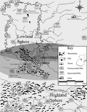
We now know that the Pasion-Verapaz straddles three distinct culture areas (Figure 3)—the northern highlands, the transversal, and the southwestern lowlands. Of the three, only the last has been studied in detail (Adams Reference Adams1971; Foias Reference Foias1996; Sabloff Reference Sabloff1975), although preliminary ceramic typologies were made in the other two regions (Arnauld Reference Arnauld1986; Dillon Reference Dillon1979; Smith Reference Smith1952). Making matters even more difficult was the intermixing of modes among the three assemblages, especially in the Late Classic period—each of the three regions had different technologies, forms, and decorations, but here the same vessel could have characteristics of two or even three of the regional traditions.
Map of the Pasion-Verapaz Region showing the three different cultural regions represented in the Late Classic assemblage. Drawing by the author (adapted from an original drawing by Walter Burgos).

Because of its high level of preservation and the large sample size due to its ease of access, the cave assemblage has become the basis of a new ceramic typology for the region (Monterroso Reference Monterroso2006; Woodfill Reference Woodfill2007, Reference Woodfill2010). This proved to be especially important for understanding the northern highland material, as the most detailed previous analysis of these ceramics (Arnauld Reference Arnauld1986) was largely unable to distinguish between Early and Late Classic materials. Because of the associated lowland wares in stratified cave deposits, lowland “flourishes,” and significant changes in ritual activity and spatial focus between the two time periods, the cave material proved to be conducive to refining the chronology.
Caves and the Ceramic Record
The cave material has also proven essential to reconstructing local culture history. Selected ceramic samples were subjected to instrumental neutron activation analysis (INAA) by Ronald Bishop, James Blackman, and Erin Sears of the Smithsonian Institution, which showed that the vessels were made with local clays with few imported vessels (Woodfill Reference Woodfill2007). Especially in the Early Classic, to which the majority of the cave assemblage dates, the ceramics were highly standardized in form, paste, and decoration within specific cave systems. When comparing the cave material from the region as a whole, however, the traditions diverged greatly over time and showed a strong break in ceramic technology at the beginning of the Late Classic. Together, these strands of data have allowed us to paint a regional culture history in broad strokes, which will be tested and refined as the Cancuen Project settlement survey continues to expand further into the Pasion-Verapaz zone.
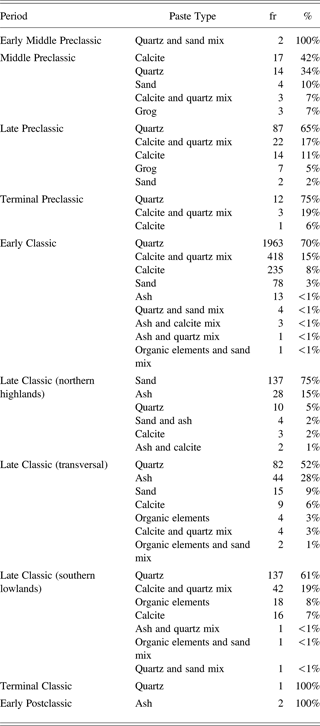
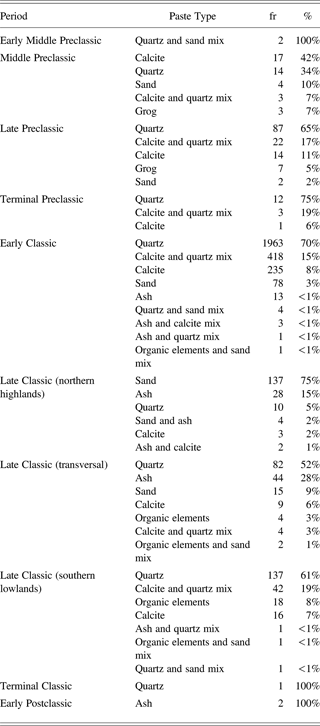
By examining the fundamental technology used to create the ceramic vessels it is possible to glean insight about the people who made them. While the surface treatment, forms, and decoration that form the basis of the Type–Variety system are constantly changing, paste—especially in utilitarian wares—tends to be much more conservative (Berlin and Slane 1997; Sanders Reference Sanders, Sanders and Michels1977; Spence Reference Spence, Mastache, Parsons, Santley and Puche1996). Analysis of ceramic variability over time in this region (Table 1) shows that ceramics were made of a typical lowland paste through the Early Classic period, one dominated by quartz and limestone tempers. During the Late Classic, however, there was a strong shift toward compositional variability in many ceramic pastes. Vessels made with ash, sand, and organic inclusions—temper types more commonly found in ceramics from the northern highlands (Arnauld Reference Arnauld1986; Butler Reference Butler, Hay, Linton, Lothrop, Shapiro and Valiant1940; Ichon and Hatch Reference Ichon and Hatch1980)—become more commonplace in the local archaeological assemblages during this period.
Paste types in the cave assemblage broken down by chronological period. The frequency (fr) and percent (%) of the paste types within the assemblage from each period are listed. The Late Classic has been further divided based on the three regional cultural affiliations shown in Figure 3
This shift was also associated with a strong break in other ceramic modes. During earlier periods, most notably the Early Classic, much of the ceramic sample was closely tied to fashions from distant centers in the central lowlands and the highlands, while the Late Classic material was highly local, idiosyncratic, and largely derived from northern highland and transversal traditions. Most strikingly, this shift occurred at roughly the same time that the majority of known settlements in the region were founded, all of which show varying degrees of the same northern highland and transversal ties. It thus appears highly probable that there was a movement of people into the region from the south around a.d. 600. The reasons for this entrada and the shift from international to local ceramic styles appear to be related to major shifts in ancient trade routes.
AN EXAMINATION OF ANCIENT TRADE ROUTES
The nature of highland-lowland trade has been of significant and lasting interest among Mayanists. One particular aspect of this, the location and history of the trade routes, has been primarily examined through ethnohistoric sources, contemporary and historic population movements, and indirect archaeological evidence (Figure 4). The earliest sources for such forays began in the seventeenth century, when Thomas Gage (Adams Reference Adams, Lee and Navarrete1978:32) reported two routes connecting the Guatemalan highlands to the Peten—the “Chinaja Trail,”—which Gage drew as a straight line connecting Coban and Lake Peten-Itza, and an eastern route passing through Dolores, Peten. Around the turn of the twentieth century, Eduard Seler speculated about two possible trade routes connecting the highlands and lowlands—the Chixoy or Chajul rivers (Seler Reference Seler, Thompson and Richardson1993a:351), and Motagua Valley (Seler Reference Seler, Thompson and Richardson1993b:324).
Approximate location of proposed highland-lowland trade routes. The Chinaha Trail (Adams Reference Adams, Lee and Navarrete1978), the Dolores Trail (Adams Reference Adams, Lee and Navarrete1978), the Chixoy Route (Arnauld Reference Arnauld1990; Seler Reference Seler, Thompson and Richardson1993a), the Motagua Route (Arnauld Reference Arnauld1990; Seler Reference Seler, Thompson and Richardson1993b), and the Great Western Trade Route (Adams Reference Adams, Lee and Navarrete1978; Arnauld Reference Arnauld1990; Demarest and Fahsen Reference Demarest, Fahsen, Laporte, Arroyo, Escobedo and Mejía2003 Hammond Reference Hammond1972). Drawing by the author (adapted from an original map by Marc Wolf).

More recently, Adams (Reference Adams, Lee and Navarrete1978), Hammond (Reference Hammond1972), and Arnauld (Reference Arnauld1990) have looked at highland-lowland trade patterns. Comparing the relative benefits of the Chinaja, Chixoy, and Motagua trails, Arnauld (Reference Arnauld1990) notes that: (1) the Chixoy is not navigable for the majority of the descent into the lowlands; (2) the Chinaja trail is the shortest route between the two regions, but it is more appropriate for lightweight materials, since everything has to be carried for a substantial part of the journey; and, (3) the Motagua—which could have been traversed completely by boat—would have been used for most of the heavy, bulky goods.
Arnauld (Reference Arnauld1990) also created a preliminary chronology for the trade routes, proposing that the Motagua was the primary route at roughly a.d. 400, but that by a.d. 600 the Chinaja trail began to compete due to increasing political instability in the southeastern Maya region. By about a.d. 750, however, the Motagua route dominated again as maritime trade became more popular, and the route has continued to attract the majority of merchants and travelers up to the present day. Nearby Lake Izabal and Río Dulce were used as a major thoroughfare for pirates during the Colonial period, necessitating the construction of a Spanish fort in the sixteenth century. The Carretera al Atlántico, the highway that runs from Guatemala City to the Caribbean along the Motagua River, is still one of the most highly-trafficked roads in Central America.
Since 1998, the Cancuen Archaeological Project and its sub-projects have been using the Petexbatun material as a starting point to create a detailed history of the Great Western Trade Route (Figure 5) (Demarest Reference Demarest2006; Demarest and Fahsen Reference Demarest, Fahsen, Laporte, Arroyo, Escobedo and Mejía2003; Demarest et al. Reference Demarest, Barrientos, Forné, Wolf, Bishop, Laporte, Arroyo and Mejía2008). Our plan (Demarest Reference Demarest2006; Demarest and Barrientos Reference Demarest, Barrientos, Demarest and Barrientos1999, Demarest and Fahsen Reference Demarest, Fahsen, Laporte, Arroyo, Escobedo and Mejía2003) was simple and direct—to explore the actual interface zone between the highlands and lowlands and document the history of interaction at the highland-lowland divide. Research has focused on what appears to have been the true Chinaja Trail, instead of the idealized line drawn by Gage (1928 [1648]) (see Figure 5), which followed a series of interconnected valleys down from Salama and Carcha to the Pasión River, at which point it would have been possible to travel by boat to most of the western lowlands.
The Great Western and Eastern Trade Routes connecting the Maya highlands and lowlands. Drawing by the author (adapted from an original drawing by Luís Luin).

Early investigations at Cancuen by Demarest and his team focused on its role as the head of navigation for the riverine half of the Great Western Trade Route in the Late Classic period (Barrientos and Demarest Reference Barrientos and Demarest2000; Demarest and Barrientos Reference Demarest, Barrientos, Demarest and Barrientos1999; Demarest and Fahsen Reference Demarest, Fahsen, Laporte, Arroyo, Escobedo and Mejía2003), and its importance as transport center of precious material from the highlands (jade, pyrite, obsidian, etc.), traveling down the valley to the river route (Barrientos and Demarest Reference Barrientos and Demarest2000). When subsequent investigations recovered apparent production areas for obsidian and jade goods, interest shifted to the possible role of Cancuen as a production center for sumptuary goods made from highland materials (Demarest et al. Reference Demarest, Barrientos, Fahsen, Laporte, Arroyo and Mejía2006; Demarest et al. 2007; Kovacevich Reference Kovacevich2006). More recent investigations (Demarest et al. 2008, 2009) and new lab work (Andrieu Reference Andrieu2009; Andrieu et al. 2011) have negated many of these earlier interpretations—while Cancuen was indeed near the head of navigation, it served as more of a transport hub than a production center. There was some final-stage obsidian production for local consumption and at least one large jade workshop, where laborers under elite supervision conducted the initial “grunt work,” transforming the jade boulders into large beads and “preforms” that were then exported for final processing by palace artisans at other major centers in the Peten (Andrieu Reference Andrieu2009; Andrieu et al. 2011).
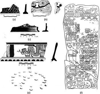
All of this activity is limited to the Late Classic period, however, beginning with Cancuen's florescence throughout the eighth century a.d and ending with its dramatic collapse around a.d 800 (Demarest Reference Demarest2006). But did the route exist in earlier time periods? With the exception of Tres Islas, an Early Classic shrine with stelae depicting Tikal-style Teotihuacano warriors (see, for example, Figure 6f) (Barrios Villar Reference Villar and Alejandro2006; Graham Reference Graham1965), the only solid evidence for interregional interaction that comes from the settlements is the newly-discovered hieroglyphic steps from Dos Pilas, which show that Tikal founded Dos Pilas to maintain control over the route before the founding of Cancuen (Demarest and Fahsen Reference Demarest, Fahsen, Laporte, Arroyo, Escobedo and Mejía2003). The cave data, however, covers a span of nearly two millennia and has proven to be a refined barometer of changes in traffic along the route.
The majority of the cave materials (16,320 sherds, 79% of the cave assemblage) dates to the latter part of the Early Classic (ca. a.d 460–550). The lion's share of this material (14,638 sherds) comes from the Candelaria Caves, the second-largest cave system in Central America, located underneath the last foothills of the Guatemalan highlands. The system appears to have been the principal shrine in the region during the Early Classic. While the instrumental neutron activation analysis mentioned above indicates that ceramics were locally produced (Woodfill Reference Woodfill2007, Reference Woodfill2010), they are done in a conspicuously central Peten style. This contrasts heavily with the few contemporaneous sherds from the region's settlements, which are technological and stylistic holdovers from the Late Preclassic, the “peripheral Chicanel” defined by Laporte and his team in the southeastern Peten (Laporte Reference Laporte, Laporte and Escobedo1995; Laporte and Corzo Reference Laporte, Corzo, Laporte, Escobedo and Arroyo2002; Laporte and Mejía Reference Laporte and Mejía2005). There as here (Woodfill Reference Woodfill2007, Reference Woodfill2010), the glossy slips and thin-walled vessels so common to the Classic period in the central Peten are largely limited to elite contexts and special ritual deposits.
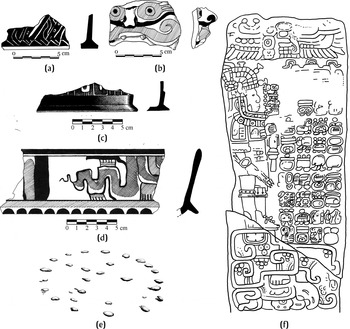
The technological and stylistic differences between the cave and settlement ceramics speaks to a strong disjoint between the ritual activity and the quotidian life of the region's population, one which becomes apparent in other parts of the cave assemblage. In addition to the lowland stone box described at the beginning of this article (Figure 1), ceramics and iconographic evidence from caves tie the ritual activity to the central Peten through slab-footed tripod cylinders (Figure 6a and 6c) (Dreux Reference Dreux1968; Woodfill Reference Woodfill2007, Reference Woodfill2010), a depiction of Tlaloc (Figure 6b) (Woodfill Reference Woodfill2007, Reference Woodfill2010), Dos Arroyos Orange polychrome basal-flanged bowls (Figure 6d), and a pecked cross (Figure 6e) (Carot Reference Carot1989). This material, combined with the evidence from Tres Islas and Dos Pilas, allowed us to push back intense use of the Great Western Trade Route to about a.d. 460.
Evidence of central Peten influence in the Pasion-Verapaz region in the Early Classic: (a) Urita Gouged-Incised slab-footed cylindrical tripod vessel (drawing by Walter Burgos); (b) polychrome Tlaloc mask (drawing by Water Burgos); (c) Urita Gouged-Incised slab-footed cylindrical tripod vessel (drawing by Luís Luin); (d) Dos Arroyos Orange Polychrome basal-flanged bowl; (e) pecked stone cross (drawing by Luís Luin based on original photograph in Carot Reference Carot1989; and, (f) Tres Islas Stela 1 (drawing by Luís Luin).
RITUAL AS ECONOMIC RESOURCE
As mentioned earlier, Brady (Reference Brady, Laporte and Escobedo1994, Reference Brady, Prufer and Brady2005b) has detailed the economic ramifications of cave ritual in the ancient Maya economy. Another related line of investigation has to do with the impact of this ritual activity on the local population (Adams and Brady Reference Adams, Brady, Laporte and Escobedo1994, Reference Adams, Brady, Brady and Prufer2005; Monterroso Reference Monterroso2006; Monterroso and Woodfill Reference Monterroso and Woodfill2006; Woodfill Reference Woodfill2007, Reference Woodfill2010). This is most obvious in the Candelaria cave system—while the caves were heavily used throughout the Classic period, there was never a large local population, even though the vast majority of ceramic material appears to have been made locally. Through production of ritual paraphernalia for the ritual practitioners using the cave system, ritual activity became an economic resource for the local population, one that would have provided material, cultural, and symbolic capital.
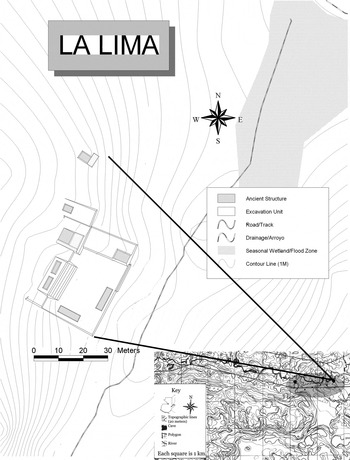
La Lima (Figure 7), a small Late Classic community at the edge of the Candelaria system, appears to have exploited the caves and cave ritual as economic resources (Monterroso Reference Monterroso2006). Every detail of the layout of La Lima created a direct association with the caves. Instead of being organized in a traditional way, the site was arranged in a linear fashion, with each architectural group several hundred meters from the next, and the two largest groups placed at opposite entrances of the last river cave of the system. The layout had the added advantage of forcing any visitors to the caves coming from the east (which is where most of the traffic likely came from) to traverse tended fields and pass alongside residences.
La Lima Group A with inset map showing location of La Lima's principal groups at eastern edge of the Candelaria Caves. Map by the author (adapted from original by Marc Wolf. Inset modified from 1:50,000 topographic map, Instituto Geográfico Nacional de Guatemala).

This would have served two principal advantages for the residents of La Lima: (1) it would have allowed them to exert a level of symbolic ownership over the caves, which would have increased their prestige; and, (2) it would likely have allowed the residents to acquire material and symbolic capital through potential “tolls,” donations, or the sale or exchange of ritual paraphernalia to visitors.
Although their Early Classic counterparts have not been identified in the incomplete settlement survey, evidence suggests that they had a similar relationship to the caves, depending on cave ritual for their livelihood. The most striking evidence for this is the noted disjoint between settlement and cave ceramic modes, even though both were locally produced. This, coupled with the sheer quantity of sherds found in caves dating to this time, indicates that there was a significant local industry based on the production of ritual paraphernalia for foreign visitors to the site.
CONCLUSIONS
The principal goal of this article is to promote the recognition that caves can provide critical—and at times central—evidence in regional culture-history aspects of ancient life. Caves often provide better-preserved ceramics and different artifacts, variants, types, and forms of the regional assemblages, and can even be used as the central thread of evidence when surface sites have been destroyed, buried, or remain undiscovered.
Caves were and are a central part of Maya religion. The material evidence found in them not only allows us insight into the nature of the rituals in which they were used, but also gives us clues about how they ended up there, who produced them, who the intended consumers were, and the myriad ways that they reflected and reinforced hierarchies of power and modes of exchange. Their role in ritual throughout history in Mesoamerica makes caves a rich source of evidence on interregional contact.
Results of the 20 years of cave investigations in the Petexbatun and Cancuen projects clearly illustrate the need to conduct a comprehensive research program that includes both settlement and sacred sites. Running a cave investigation in tandem with a regional settlement survey will provide a more holistic perspective on the history of the region and fill in gaps in the record. The relative speed at which a cave survey can acquire a large sample of material from disparate time periods can create an engaging model for regional culture history to be tested by future research.
Caves and surface assemblages have specific advantages and disadvantages. Cave materials are, for the most part, much more easily accessible due to the lack of deep depositional processes that bury most of the archaeological record. They also tend to have much better preservation, allowing for quick comparisons to assemblages from other sites and regions, and allowing rough culture-historical models to be created. Cave assemblages are still fundamentally the result of ritual activity and the majority of people's lives did take place outside of cave contexts, so caves should be considered to be an initial foray into culture-historical models, ones which should be tested with subsequent research both on and under the ground.
Coordination of subterranean and surface archaeology has had significant advantages during the past 20 years of the Petexbatun and Cancuen project research, and the incorporation of a cave sub-project into more regional investigations in Mesoamerica would result in similar breakthroughs. Cave archaeologists should use their data to address a wider range of issues which will, fundamentally, do much to promote the utility of their sub-discipline and its unity with the general discipline of archaeology. For while caves are—and shall forever remain—sacred places and the focus of ritual activities, they can successfully be used to inform on a wide variety of major questions on ancient Mesoamerica.
RESUMEN
Las cuevas eran (y todavía son) una parte central de la cosmología, ritual y religión de Mesoamérica. Aunque los datos de cuevas han estado creciendo exponencialmente desde los años ochenta, una incompatibilidad percibida todavía existe entre los ensamblajes de cuevas y superficie. Aún así, en la región Pasión-Verapaz, las cuevas han sido una parte integral de las investigaciones regionales, normalmente dirigiendo subsecuentes reconocimientos, estudios de patrones de asentimiento y excavaciones de sitios mayores y menores.
Este artículo es un intento para casar la arqueología de cuevas con la arqueología tradicional, dando ejemplos de como se puede usar datos de cuevas para examinar los problemas principales en interpretación arqueológica. En particular, los datos de cuevas están usados para examinar la naturaleza de poder élite, patrones de asentimiento, cronología cerámica, la historia de intercambio interregional y la economía precolombina.
El poder élite fue establecido por su relación con los dioses y el mundo sobrenatural, una relación que enseñaron por extravagantes ritos enfrente de una audiencia y ritos hechos “bajo puertas cerradas”; evidencia de los dos existen en el ensamblaje de cuevas. En igual forma, cuevas eran lugares sagrados, y los patrones de uso muestran las funciones y cambios por tiempo de la geografía sagrada.
Aparte de eso, las cuevas pueden ser buena fuente de datos sobre otros asuntos lejanos de lo ritual. En la región estudiada por el autor, las cuevas tienen amplia evidencia de una población local antes del clásico tardío, una época casi invisible en los sitios de la superficie hasta el presente. Por su buena preservación y asociación con tipos mayormente definidos, la cerámica de estas cuevas también nos ha ayudado a construir una mejor cronología cerámica en una región pocamente entendida y estudiada.
Las cuevas estudiadas por el autor se encuentran a la par de la Gran Ruta Occidental de Intercambio, una de las dos arterias principales que conecta las Tierras Bajas mayas con el Altiplano, y resultan ser barómetros muy sensitivos para examinar cambios de tráfico en la ruta. También resultan ser importantes fuentes para entender la economía precolombina—no solo que las cuevas son el destino final de una gran parte de las bienes no perecederas como jade, piedra tallada y cerámica de alta calidad (Brady Reference Brady, Laporte and Escobedo1994, Reference Brady, Prufer and Brady2005b), pero también, en el caso de las cuevas usadas por peregrinos y mercaderes de intercambio de larga distancia, formaron la base de la economía local para las aldeas cercanas que produjeron la parafernalia ritual usada en ceremonias.
ACKNOWLEDGMENTS
This paper came out of a series of talks with Arthur Demarest, Jon Spenard, Jim Brady, Ron Bishop, and Mirza Monterroso.
Thanks to Arthur Demarest for making suggestions on several drafts of this paper, to Vilma Anleu for helping to decipher said suggestions, to Mirza Monterroso for proofing the Spanish summary and editing the figures, to the reviewers of the original submission of this article for their helpful critiques, and to the editors and board of Ancient Mesoamerica for getting this article out quickly and in good shape.
The research that formed the basis of this article was made possible through the assistance of the Foundation for the Advancement of Mesoamerican Archaeology, Inc.; the United States Agency for International Development; Chemonics, Inc.; Fortalecimiento Institucional de Políticos Ambientales; the Ahau Foundation; and the Vanderbilt Institute of Mesoamerican Archaeology.