INTRODUCTION
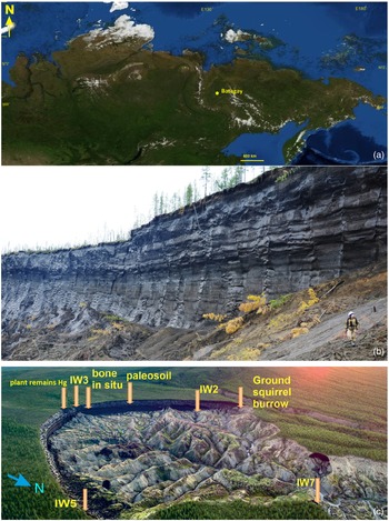
The Batagay megaslump (67.58°N, 134.77°E) is the largest one on Earth and located close to the Batagay settlement on the right bank of the Yana River in Yakutia, eastern Siberia (Figure 1a). The megaslump of the Batagay yedoma is located higher than other outcrops of the yedoma strata, at an altitude of 320 m above sea level (a.s.l.). It is further one of the largest permafrost thaw features (retrogressive thaw slumps) on Earth. The depth of the outcrop varied in separate parts from about 92 m (referring to the maximum height differences between the top of the ravine in the center and the bottom of the outflow of the slump into the Batagaika River) to 55 m below ground surface (b.g.s.) and varies from year to year due to thermal erosion. According to Jongejans et al. (Reference Jongejans, Mangelsdorf, Karger, Opel, Wetterich, Courtin, Meyer, Kizyakov, Grosse, Shepelev, Syromyatnikov, Fedorov and Strauss2022) the central headwall rises 50–55 m above the slump floor. Studies of the exposed permafrost strata in recent years provided some interesting results such as the detailed description of the outcrop, the differentiation into stratigraphic units and the application of 14C dating, optically stimulated luminescence (OSL), infrared stimulated luminescence (IRSL), post-infrared infrared luminescence dating of K-feldspar grains (pIRIR) and 36Cl/Cl (Murton et al. Reference Murton, Edwards, Lozhkin, Anderson, Savvinov, Bakulina, Bondarenko, Cherepanova, Danilov and Boeskorov2017, Reference Murton, Opel, Toms, Blinov, Fuchs, Wood, Gärtner, Merchel, Rugel, Savvinov and Wetterich2022; Ashastina et al. Reference Ashastina, Schirrmeister, Fuchs and Kienast2017; Vasil’chuk et al. Reference Vasil’chuk, Vasil’chuk, Budantseva, Vasil’chuk and Trishin2017, Reference Vasil’chuk, Vasil’chuk, Budantseva, Vasil’chuk and Trishin2019, Reference Vasil’chuk, Vasil’chuk, Budantseva and Vasil’chuk2020; Opel et al. Reference Opel, Murton, Wetterich, Meyer, Ashastina, Günther, Grotheer, Mollenhauer, Danilov and Boeskorov2019). Additionally, paleobotanical and pollen data as well as stable isotope records have been obtained (Murton et al. Reference Murton, Edwards, Lozhkin, Anderson, Savvinov, Bakulina, Bondarenko, Cherepanova, Danilov and Boeskorov2017, Reference Murton, Opel, Toms, Blinov, Fuchs, Wood, Gärtner, Merchel, Rugel, Savvinov and Wetterich2022; Vasil’chuk et al. Reference Vasil’chuk, Vasil’chuk, Budantseva, Vasil’chuk and Trishin2017, Reference Vasil’chuk, Vasil’chuk, Budantseva, Vasil’chuk and Trishin2019, Reference Vasil’chuk, Vasil’chuk, Budantseva and Vasil’chuk2020; Ashastina et al. Reference Ashastina, Kuzmina, Rudaya, Troeva, Schoch, Römermann and Reinecke2018; Opel et al. Reference Opel, Murton, Wetterich, Meyer, Ashastina, Günther, Grotheer, Mollenhauer, Danilov and Boeskorov2019). However, the paleochronology and paleoclimate records of the Batagay yedoma require further studies including Accelerator Mass Spectrometry (AMS) 14C dating and isotope studies of wedge ice (Opel et al. Reference Opel, Murton, Wetterich, Meyer, Ashastina, Günther, Grotheer, Mollenhauer, Danilov and Boeskorov2019). Variations in stable water isotopes of ice wedges preserve information on air temperature and moisture source for the cold season. The δ18O values of ice wedges have been previously interpreted as a proxy of winter air temperature (e.g., Vasil’chuk Reference Vasil’chuk1991; Opel et al. Reference Opel, Meyer, Wetterich, Laepple and Murton2018; Porter and Opel Reference Porter and Opel2020; Campbell-Heaton et al. Reference Campbell-Heaton, Lacelle and Fisher2021). If combined with other paleoclimate approaches, ice-wedge stable isotope can enhance our understanding of seasonality of past climates. Here, we present results of our work at the Batagay megaslump carried out in 2017–2021 (Figure 1c). The objective of this study is to deduce paleo winter temperatures from MIS 3–2 wedge-ice stable water isotopic compositions and 14C dating of syngenetic permafrost and ice wedges exposed in the Batagay permafrost sequence.
(a) Location map of Batagay megaslump in northeast Siberia (Yandex maps), (b) general view of main wall of Batagay exposure (photo by Y.K. Vasil’chuk), (c) approximate sampling locations of ice wedges and host sediments (orange arrows) (photo credit: K. Orlinsky).

METHODS
Fieldwork
Three ice wedges named as IW-3, IW-5, IW-7 were sampled with cordless drills BOSCH GSR 18V-EC TE and Makita DDF481RTE 188 equipped with special titan drilling nozzles. Samples were taken in at least 0.2–0.3 m distance, along both the vertical and horizontal axes of exposed wedge ice. Samples for isotope analysis were taken from the same ice wedges along the vertical and horizontal axes to compare the spatial isotopic variations inside distinct ice wedges. In order to exclude the possible participation of modern water entering the surface of the ice and modern organic material, the outermost about 5–10 cm of the ice was removed before sampling as the samples were taken at a temperature above the freezing point. The cleaver blade and drilling nozzle were cleaned before sampling of each new sample. The sample volume for isotope analysis was 10–15 cm3, the number of single veins in each sample did not exceed 10. Each ice sample for 14C dating was scraped off with clean blades to remove surface dirt and washed with clean melt water from the same sample of ice. Single veins were counted in each sample. Ice samples for 14C dating melted at a temperature of about 5°C for 24 hr. The residue was then collected in plastic vials. The ice samples for stable isotope analyses melted on site in double plastic zip-bags, and 25 mL plastic vials were filled with melt water, then tightly closed and sealed with parafilm to avoid evaporation. They were stored under cool conditions. We traced the axial part of the ice wedge by all means. Since the Batagay ice wedges are characterized by frequent intersections, the axial part may be visually located close to the edge of the ice wedge in photo. The host sediments with organic material were sampled for conventional 14С dating from the frozen wall after removal of the outermost thawed material. We have visited the Batagay megaslump three times in 2017–2021 and made height measurements with a laser rangefinder Leica DISTO 5910. The height interval ranges from 227 to 320 m a.s.l. between the lowest and the highest surface of the slump edge, respectively.
Radiocarbon Age Measurements
Pretreatment for counting material was carried out in the Laboratory of Radiocarbon Dating and Electron Microscopy of the Institute of Geography of the Russian Academy of Sciences and AMS radiocarbon dating was conducted in the Center for Applied Isotope Studies at the University of Georgia, United States (lab ID is IGANAMS-). AMS measurements were performed using National Electrostatics Corporation (NEC) model 1.5SDH-1 Pelletron accelerator capable of accelerating the +1 charged ions to about 1 MeV. Conventional radiocarbon dating of organic matter in permafrost sediments was carried out in the Institute of the History of Material Culture of the Russian Academy of Sciences (lab ID is Le).
Stable Isotope Measurements
The oxygen and hydrogen isotope compositions of the ice were measured in a constant helium flux mode (CF-IRMS) on a Delta-V mass spectrometer using a gas-bench complex, at the Isotope Laboratory of the Geography Department, Lomonosov Moscow State University (MSU). Calibration was performed using the Vienna Standard Mean Ocean Water (VSMOW) and Standard Light Antarctic Precipitation (SLAP) international standards, as well as the MSU internal laboratory standard – snow from the Garabashi glacier (Elbrus area, Greater Caucasus), with δ18O = –15.6‰ and δ2H = –110‰. The errors of measurements were ±0.6‰ and ±0.1‰ for δ2H and δ18O, respectively. The total number of isotope samples from ice wedges presented in this paper amounts to 171. Data are given as per mille (‰) difference from VSMOW.
Stable Isotope and Air Temperature Relationship
To establish the relationship between the ice wedge δ18O values and air temperature we compared winter and January air temperatures and the δ18O values of modern ice wedges (or veinlets) in different regions of the Eurasian permafrost area (Vasil’chuk Reference Vasil’chuk1991, Reference Vasil’chuk1992). These relationships are expressed in the following simplified regression equation: tmJ = 1.5δ18Oiw (±3°C) where tmJ is the mean January air temperature of the period of ice wedge formation; δ18Oiw is oxygen isotope composition of the ice wedge. Certainly, the interpretation of ice wedge isotope composition is complex and local processes must be considered as it has been shown by Opel et al. (Reference Opel, Meyer, Wetterich, Laepple and Murton2018) and Campbell-Heaton et al. (Reference Campbell-Heaton, Lacelle and Fisher2021). We took in account edge effects which led to increasing δ18O values towards the contact with the surrounding icy permafrost and collect the ice no closer than 0.3 m from the edge of the wedge.
The data of meteorological observations from 1930 to 2017 and the values of δ18O in the veinlets near weather stations for several regions of the permafrost area in Northern Eurasia are analyzed in order to identify the most obvious and stable dependence of the isotopic composition and winter temperature for relatively warm and cold winter seasons (Vasil’chuk and Surkova Reference Vasil’chuk and Surkova2020). The comparison of the regression equations allowed to conclude that they are quantitatively similar, and corrections for warmer and colder winters are within statistical error (Vasil’chuk and Surkova Reference Vasil’chuk and Surkova2020). This proves the validity of the previously derived relationships from Vasil’chuk (Reference Vasil’chuk1991) and the paleoreconstructions based on them (Vasil’chuk and Vasil’chuk Reference Vasil’chuk and Vasil’chuk2020, Reference Vasil’chuk and Vasil’chuk2021).
RESULTS
Radiocarbon data were obtained to verify the formation time of ice wedges in the Upper Ice Complex of the Batagay yedoma. Furthermore, a cryostratigraphic description and the detailed vertical distribution of the δ18O, δ2H, and dexc values of the three studied ice wedges is provided.
Cryostratigraphy
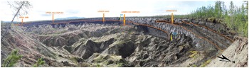
A vertical wall of permafrost deposits is exposed from the surface to a depth of about 55 m b.g.s. (Figure 1b). The permafrost sequence exposed in the Batagay megaslump differentiates into main stratigraphic units (Opel et al. Reference Opel, Murton, Wetterich, Meyer, Ashastina, Günther, Grotheer, Mollenhauer, Danilov and Boeskorov2019) by erosional discordances, differing cryostratigraphic features such as wedge ice volume and according to the dating results by 14C, OSL, IRSL, 36Cl/Cl, pIRIR (Murton et al. Reference Murton, Opel, Toms, Blinov, Fuchs, Wood, Gärtner, Merchel, Rugel, Savvinov and Wetterich2022). The Holocene cover is dated to 10,520 to 390 cal BP, the Upper Sand to 42,390 to 15,090 cal BP; the Upper Ice Complex to 52,210 to 27,160 cal BP; the Lower Sand to >123.2 kyr (OSL), 142.8 ± 25.3 kyr (OSL) and 210 ± 23 kyr (IRSL), and the Lower Ice Complex to 658 ± 74 kyr to 693 ± 97 kyr (pIRIR) and 624 ± 51 kyr (36Cl/Cl). Between the Upper Ice Complex and the Lower Sand there is a wood debris layer up to 3 m in thickness that occurs in distinct lenses (Figure 2). We focused on the study of the MIS 3–2 the Upper Ice Complex. In the westernmost part of the outcrop, the Upper Ice Complex sequence is subdivided into two parts, the upper one was 10–12 m thick and the lower one was about 10–15 m thick (Figure 2). Thin ice wedges of not wider than 1.5–2 m occur in the upper part and in the upper sand unit. The tops of these ice wedges of the upper part of the Upper Ice Complex are located close to the surface, wedges often cross each other. The host sediments bodies separating the ice wedges are 1.5–3 m wide and characterized by micro-lenticular cryostructure. Ice wedge No. 3 (IW-3) occurs at 5–10 m b.g.s. or 315–320 m a.s.l. in a ravine opened to the headwall of the exposure (Figures 1c, 2). Ice wedge No. 5 (IW-5) is located in the southern part of the megaslump between 266 and 282 m a.s.l. (Figure 1c). IW-5 is up to 16 m high, and up to 1.5 m wide, while the upper 8 m are not exposed and covered by a debris talus. Ice wedge No. 7 (IW-7) is more than 13 m high and about 2 m wide at 2.4–12.8 m b.g.s (239–227 m a.s.l.) is exposed east of IW-5 in the narrow part of the megaslump in southwestern wall (Figure 1c).
Panoramic photograph of the Batagay megaslump with main stratigraphic units (according to Opel et al. Reference Opel, Murton, Wetterich, Meyer, Ashastina, Günther, Grotheer, Mollenhauer, Danilov and Boeskorov2019; Murton et al. Reference Murton, Opel, Toms, Blinov, Fuchs, Wood, Gärtner, Merchel, Rugel, Savvinov and Wetterich2022), orange arrows show the main stratigraphic units, yellow arrows show locations of ice wedges mentioned in the text (photo by Y.K. Vasil’chuk).

Radiocarbon Age
Site IW-3
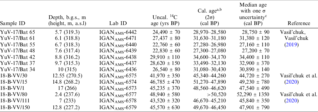
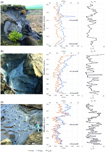
Seven new AMS 14C dates were obtained in the upper generation of ice wedges from the axial part of IW-3; all of them yield finite ages (Table 1). According to the principle of choosing-the-youngest date (Vasil’chuk and Vasil’chuk Reference Vasil’chuk and Vasil’chuk2017), we consider the lowermost dated sample of the youngest age as most likely corresponding to the age of sediment and ice in syngenetic permafrost. We suppose that the dates 30,890 cal BP (10.0 m b.g.s.) and 27,160 cal BP (6.7 m b.g.s.) are valid (Figure 3b). Accordingly, we assume that reworked organic matter in various amounts is present in other ice samples both in the upper and lower parts of the IW-3 (Figure 3: 28,750 cal BP; 31,380 cal BP; 27,150 cal BP; 34,400 cal BP; and 32,900 cal BP).
14C AMS dates of unidentified organic material. from the ice wedges: IW-3, IW-5, IW-7.

a The resulting 14C ages were calibrated using the IntCal20 calibration curve (Reimer et al. Reference Reimer, Austin, Bard, Bayliss, Blackwell, Bronk Ramsey, Butzin, Cheng, Edwards, Friedrich, Grootes, Guilderson, Hajdas, Heaton, Hogg, Hughen, Kromer, Manning, Muscheler, Palmer, Pearson, van der Plicht, Reimer, Richards, Scott, Southon, Turney, Wacker, Adolphi, Büntgen, Capano, Fahrni, Fogtmann-Schulz, Friedrich, Köhler, Kudsk, Miyake, Olsen, Reinig, Sakamoto, Sookdeo and Talamo2020) and the Oxcal version 4.4.4 program (Bronk Ramsey Reference Bronk Ramsey2021).
b Ages were calibrated to calendar years before present (where present is 1950 A.D.) using the IntCal20 calibration curve; age ranges at the 95.4% probability level.
c Calendar ages are the median age with one sigma uncertainty. Sample processing completed at the Institute of Geography of RAS, analyses completed at the University of Georgia radiocarbon facility.
Field photographs and vertical stable isotopic compositions of (a) IW-3, in the upper part of the Upper Ice Complex; (b) IW-5 lower part of Upper Ice Complex; (c) IW-7 lower part of Upper Ice Complex. Note: the elevations indicated in the plots correspond to the scale of the photos. (Photos by Y.K. Vasil’chuk – a, and A. Trishin – b, c).

The 14C dates confirm the time of syngenetic formation of the IW-3 ranging from 30,900 to 27,000 cal BP. A fragment of IW-3 (6.7–10 m b.g.s.) accumulated approximately over 3730 years between 30,890 ± 140 and 27,160 ± 110 cal BP, assuming a constant ice-wedge growth, the entire studied fragment of IW-3 accumulated over 4100 years.
Site IW-5
In the lower generation (lower 10–15 m of Upper Ice Complex) of ice wedges, three samples of organic matter from the axial part of IW-5 were selected for AMS 14C dating. All three yielded a finite age. We suppose that the age 49,230 cal BP (14.8 m b.g.s.), was obtained from the sample with high concentration of reworked organic matter. The obtained ages reflect the overall formation period of the wedge ice and should a priori be omitted if disturbing the age–depth relationship i.e., the older date from the ice-wedge axis is located above. The other obtained dates of 44,720 cal BP (12.5 m b.g.s.) and 47,540 cal BP (17.0 m b.g.s.) are most likely valid (Figure 3b). Based on the assumption that the ice wedges accumulated evenly over 5 m in the entire studied fragment of IW-5, accumulation occurred over about 7800 years.
Site IW-7
This ice wedge also refers to the lower generation of ice wedge formation within Upper Ice Complex. Three samples of organic matter from the axial part of IW-7 were selected for AMS 14C dating. In total, three new dates were obtained (Figure 3c), and all of them are finite. We assume that one of the dates (52,290 cal BP, 2.4 m b.g.s) was obtained from older organic material that had been reworked in the ice. The other two obtained dates of 45,840 cal BP (at a depth b.g.s. of 7 m) and 47,910 cal BP (at a depth b.g.s. of 12.8 m) are most likely, because they do not disturb the age–depth relationship.
The new conventional radiocarbon dates were obtained from the host deposit. In detail, organic material from a paleosoil surrounding IW-3 and from a “in situ” bone and from a ground squirrel burrow in the ravine has been dated (Table 2, Figure 1c), all of them with a finite age and the previously obtained dating of Upper Ice Complex deposits is confirmed (Murton et al. Reference Murton, Edwards, Lozhkin, Anderson, Savvinov, Bakulina, Bondarenko, Cherepanova, Danilov and Boeskorov2017, Reference Murton, Opel, Toms, Blinov, Fuchs, Wood, Gärtner, Merchel, Rugel, Savvinov and Wetterich2022; Ashastina et al. Reference Ashastina, Schirrmeister, Fuchs and Kienast2017, Reference Ashastina, Kuzmina, Rudaya, Troeva, Schoch, Römermann and Reinecke2018; Opel et al. Reference Opel, Murton, Wetterich, Meyer, Ashastina, Günther, Grotheer, Mollenhauer, Danilov and Boeskorov2019). The 14C date 25,150 ± 3000 BP (Table 2) of undefined plant remains of the ground squirrel burrow is close to the 14C date of 26,180 ± 220 BP or from 30,930 to 30,050 (mean 30,470) cal BP of Plantago sp., Artemisia sp. remains in the ground squirrel burrow obtained by Ashastina et al (Reference Ashastina, Schirrmeister, Fuchs and Kienast2017) at 4.5 m b.g.s. in the northwest part of megaslump. Conventional 14C ages of organic material from the paleosoil and bone sampled in vicinity of IW-3 fall within the dating interval obtained by Murton et al. (Reference Murton, Opel, Toms, Blinov, Fuchs, Wood, Gärtner, Merchel, Rugel, Savvinov and Wetterich2022) for the upper ice Upper Ice Complex (52,210–27,160 cal BP). In vicinity of IW-3 at a depth of 0.5 m, undefined plant remains are dated to the Holocene (Table 2, Figure 1c), the date 10,510 cal BP was obtained.
Conventional and AMS radiocarbon dates in the sediments surrounding IW-3 of Batagay yedoma.

a The resulting 14C ages were calibrated using the IntCal20 calibration curve (Reimer et al. Reference Reimer, Austin, Bard, Bayliss, Blackwell, Bronk Ramsey, Butzin, Cheng, Edwards, Friedrich, Grootes, Guilderson, Hajdas, Heaton, Hogg, Hughen, Kromer, Manning, Muscheler, Palmer, Pearson, van der Plicht, Reimer, Richards, Scott, Southon, Turney, Wacker, Adolphi, Büntgen, Capano, Fahrni, Fogtmann-Schulz, Friedrich, Köhler, Kudsk, Miyake, Olsen, Reinig, Sakamoto, Sookdeo and Talamo2020) and the OxCal version 4.4.4 program (Bronk Ramsey Reference Bronk Ramsey2021).
b Ages were calibrated to calendar years before present (where present is 1950 AD) using the IntCal20 calibration curve; age ranges at the 95.4% probability level.
c Calendar ages are the median age with one sigma uncertainty. Sample processing completed at the Institute of the History of Material Culture of the Russian Academy of Sciences. Sample processing completed at the Institute of Geography of RAS, analyses completed at the University of Georgia radiocarbon facility.
The ice wedges were sampled at different altitudes representing different formation periods. These three profiles (Figures 2, 3) allow for a record which differentiates periods: IW-7 (early MIS 3; 47,900–45,800 cal BP); IW-5 (early MIS 3; 47,500–44,700 cal BP); IW-3 (early MIS 2; 30,800–27,100 cal BP).
Stable Isotope Ratios
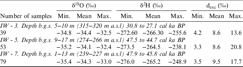
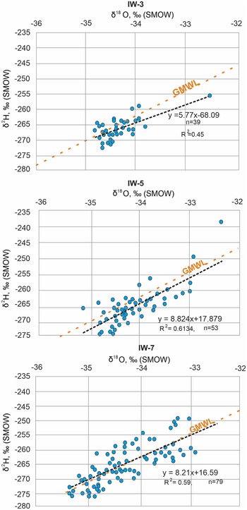
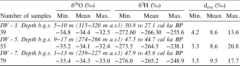
The stable isotope composition of the ice wedges is homogenous, δ18O and δ2H values are strongly depleted (Table 3). IW-3 shows a mean isotopic composition of −34.4‰ for δ18О, −266.3‰ for δ2H, and 8.6‰ for dexc (n = 39; Figure 3A). The co-isotopic regression is δ2H = 5.77 δ18О−68.09 (R2 = 0.45) (Figure 4). The stable isotope composition of the IW-5 fluctuates over a larger range than that of IW-3 (Table 3). The mean values are −34.1‰ for δ18О, −264.5‰ for δ2H, and 8.6‰ for dexc (n=53; Figure 3B). The co-isotopic regression is δ2H = 7.67 δ18О−2.84 (R2 = 0.54) (Figure 4). The plot coincides well with the Global Meteoric Water Line (GMWL, δ2H=8 δ18О + 10; Craig Reference Craig1961). The stable isotope composition of IW-7 is close to that of IW-5. Its mean values are −34.33‰ for δ18О, −265.18‰ for δ2H, and 9.48‰ for dexc, (n=79; Figure 3C). The regression line in a δ18О-δ2H bi-plot is δ2H = 8.21δ18О−16.59 (R2 = 0.59) (Figure 4), which is also close to the GMWL. Poor coefficients R2 given in this section: 0.45 for IW-3, 0.54 for IW-5 and 0.59 for IW-7 may be explained by climatic features during the formation of ice wedges, in particular, the sublimation of snow. Similar values of the coefficients of the regression equation were obtained for Holocene ice wedges in the valley of the Chara River in Transbaikalia in the area of high continentality (Vasil’chuk et al. Reference Vasil’chuk, Vasil’chuk and Stanilovskaya2018; Budantseva and Vasil’chuk Reference Budantseva and Vasil’chuk2021) and for ice wedges of lower stage in Bison on the Kolyma River (unpublished data). Another explanation is the crowding of points on the co-isotope diagram, in this case the regression equation often has an unusual appearance.
Ranges of minimum (Min.), maximum (Max.) and mean of δ18О and δ2H values in ice wedges as well as 14C age ranges of isotope records of Upper Ice Complex of Batagay.
Co-isotopic δ2H-δ18O diagrams of ice wedges IW-3, IW-5, IW-7. GMWL (Global Meteoric Water Line) describes the global annual average relationship between hydrogen and oxygen isotope (Deuterium-Oxygen-18 and) ratios in natural meteoric waters (δ2H=8 δ18О + 10).

DISCUSSION
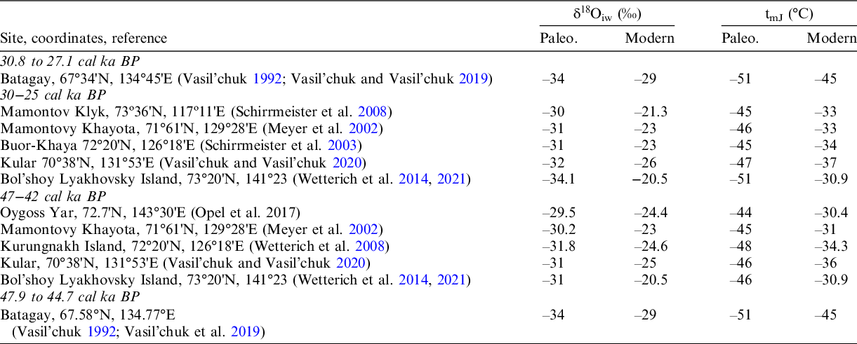
Stable isotope plots were obtained from ice wedges of the Batagay megaslump (Vasil’chuk et al. Reference Vasil’chuk, Vasil’chuk, Budantseva, Vasil’chuk and Trishin2019). These allowed the reconstruction of very severe winter conditions in the Verkhoyansk district of Yakutia during the Late Pleistocene. The chronological setting of ice wedge formation was determined based on the 14C dating of the host sediments (Ashastina et al. Reference Ashastina, Schirrmeister, Fuchs and Kienast2017). Special studies on the accumulation of organic material in the sediments of yedoma allowed us to assume that the accumulation of organics of different ages is characteristic of Ice Complex (Vasil’chuk and Vasil’chuk Reference Vasil’chuk and Vasil’chuk2017). Therefore, a values of the youngest dating most likely reflects age of ice wedges and host sediments of Ice Complex. Several inversions of radiocarbon ages have also been found among the dates obtained from organic matter from the Batagay Upper Ice Complex sediments (Ashastina et al. Reference Ashastina, Schirrmeister, Fuchs and Kienast2017; Murton et al. Reference Murton, Edwards, Lozhkin, Anderson, Savvinov, Bakulina, Bondarenko, Cherepanova, Danilov and Boeskorov2017; Vasil’chuk et al. Reference Vasil’chuk, Vasil’chuk, Budantseva, Vasil’chuk and Trishin2019). In our opinion, the most reliable 14C-ages obtained by Murton et al (Reference Murton, Edwards, Lozhkin, Anderson, Savvinov, Bakulina, Bondarenko, Cherepanova, Danilov and Boeskorov2017) and K. Ashastina et al. (Reference Ashastina, Schirrmeister, Fuchs and Kienast2017) are as follows: 12,660 ± 50 BP (Poz-79756) or from 15,260 to 14,940 (median 15,090) cal BP from 8.5 m b.g.s., 36,300 ± 700 BP (Poz-75782) or from 42,220 to 41,290 BP (median 40,130) cal BP from 18.5 m b.g.s. and 49,320 ± 3150 BP (MAG-2047) or from infinite to 47,730 (median 51,690) cal BP from 47 m b.g.s. Our 14С dates obtained from the ice wedges allowed us to date the formation time of studied ice wedges in the Upper Ice Complex from 47.9 to 27.16 cal ka BP. This matches with previously obtained radiocarbon dating results (Ashastina et al. Reference Ashastina, Schirrmeister, Fuchs and Kienast2017; Murton et al. Reference Murton, Edwards, Lozhkin, Anderson, Savvinov, Bakulina, Bondarenko, Cherepanova, Danilov and Boeskorov2017, Reference Murton, Opel, Toms, Blinov, Fuchs, Wood, Gärtner, Merchel, Rugel, Savvinov and Wetterich2022; Opel et al. Reference Opel, Murton, Wetterich, Meyer, Ashastina, Günther, Grotheer, Mollenhauer, Danilov and Boeskorov2019). It has been shown that the finite age range of the Upper Ice Complex spans from 52.2 to 27.2 cal ka BP (Table 5 in Murton et al. Reference Murton, Opel, Toms, Blinov, Fuchs, Wood, Gärtner, Merchel, Rugel, Savvinov and Wetterich2022). Based on detailed isotope data (171 samples) from three ice wedges of the present study, the average January temperatures of the late Pleistocene were calculated from 30.8 to 27.1 cal ka BP (IW-3), from 47.5 to 44.7 cal ka BP (IW-5) cal BP and from 47.9 to 45.8 cal ka BP (IW-7) cal BP for the Batagay megaslump (Table 4). For comparison, we further calculated average January temperatures from number of other yedoma sequences in the north-west of Yakutia (Table 4). Similar Deuterium excess values indicate comparable moisture sources during MIS 3 and MIS 2 near Batagay.
Average January (tmJ) paleotemperature in the northwest of Yakutia, reconstructed using Vasil’chuk’s (1991) relationship between δ18Oiw and tJ°C: tmJ = 1.5δ18Oiw (±3°C).

It was shown that the lowest average January air temperature during MIS 3–2 prevailed in the Batagay region (–51°С), while in areas located 500–600 km to the north, it was 4–5°С warmer 30 to 25 cal ka BP, and 5–7°С warmer from 47 to 42 cal ka BP. These severe winter climate conditions are explained by the existence of a stable Siberian anticyclone during the Late Pleistocene (from 25,000 to 47,000 cal BP (Vasil’chuk Reference Vasil’chuk1992; Opel et al. Reference Opel, Murton, Wetterich, Meyer, Ashastina, Günther, Grotheer, Mollenhauer, Danilov and Boeskorov2019; Vasil’chuk et al. Reference Vasil’chuk, Vasil’chuk, Budantseva, Vasil’chuk and Trishin2019), which center in MIS 3–2 shifted slightly to the north due to partial drainage of the shelf (Vasil’chuk Reference Vasil’chuk1992). We have not found a MIS 2 winter cooling towards the Last Glacial Maximum (LGM) in our Batagay dataset, which is seen in directly dated ice-wedge stable isotope records from Bol’shoy Lyakhovsky Island (Wetterich et al. Reference Wetterich, Meyer, Fritz, Mollenhauer, Rethemeyer, Kizyakov, Schirrmeister and Opel2021). This can be explained both by regional climatic features and by the fact that the youngest ice presented here slightly predates LGM, and LGM ice has not been captured by our present study. As it has been shown by Porter and Opel (Reference Porter and Opel2020) distinct LGM wedge-ice records showing extremely cold winter conditions are rare on the circum-arctic scale. However, in the Batagay, the lowest δ18O values –37.2‰ were obtained at a depth b.g.s. of 54 m in the ice wedge 2 (Figure 1c) (Vasil’chuk et al. Reference Vasil’chuk, Vasil’chuk, Budantseva, Vasil’chuk and Trishin2017), i.e., a record where indeed extremely winter cooling is seen found in Batagay ice wedges. However, it presumably formed during the MIS 4 since it is located at the bottom of the Upper Ice Complex and its radiocarbon ages are infinite. Based on our tmJ reconstructions a similar mean January temperature of –55.5°C can be assumed for the MIS 2 (LGM) winter cooling on Bol’shoy Lyakhovsky Island (Wetterich et al. Reference Wetterich, Meyer, Fritz, Mollenhauer, Rethemeyer, Kizyakov, Schirrmeister and Opel2021) and for IW-2 formation period in Batagay (Vasil’chuk et al. Reference Vasil’chuk, Vasil’chuk, Budantseva, Vasil’chuk and Trishin2017).
CONCLUSIONS
The high-resolution systematic sampling and dating of ice wedges of Batagay improve the temporal resolution of the Batagay ice wedge record during MIS 3–2. The 14С dates obtained from the ice wedges allowed to date the formation time of studied ice wedges in the Upper Ice Complex from 47.9 to 27.2 cal ka BP. Based on the stable isotope record (171 samples), the average January temperature during the Late Pleistocene was consistently low at –51ºС for both periods from 30,800 to 27,100 cal BP (MIS 2) and from 47,900−44,700 cal BP (MIS 3) in the Verkhoyansk district of Yakutia.
CONFLICT OF INTEREST STATEMENT
The authors state that they have no conflicts of interest.
ACKNOWLEDGMENTS
We would like to express our gratitude to Andrey Trishin and Alexander Ginzburg—our field assistants, also to Dr. Elya Zazovskaya and Dr. Hanna Zaitseva for their help in radiocarbon analyses. The manuscript benefited from constructive reviews by Associate Editor Dr. Yaroslav Kuzmin, and Dr. Sebastian Wetterich, Dr. Thomas Opel, and one anonymous reviewer. This work was supported by the Russian Foundation for Basic Research (grant no. 20-05-00782, stable isotope analysis), the Development Program of the Interdisciplinary Scientific and Educational School of M.V. Lomonosov Moscow State University “Future Planet and Global Environmental Change” and state budget theme 1.4. «Anthropogenic geochemical transformation of the components of landscapes».