

Amelia Evans Barry was distraught. Far from most of her remaining family and friends in London, Amelia was effectively stranded in Pisa, Italy.Footnote 1 Her husband David had died less than 2 months earlier and she was pregnant with four children to care for, while rapidly running out of funds. Writing in December of 1781 to her friend and godfather, Benjamin Franklin, Amelia described how “the calls of poverty, and the cries of infant innocence, equally impel me now to exert every effort to obtain some assistance.”Footnote 2 A former governess and aspiring author, Amelia's source of income lay in her intellectual labors. The support that Amelia sought was from such another source of intellectual labor, left to her by her father, the geographer Lewis Evans, decades before. Referencing “the Sale of the Map & Pamphlet,” Amelia implored Franklin to intervene in a copyright dispute, one that stretched back over 25 years, to the other side of the globe. Amidst a complex web of textual property, intellectual labor, and unclear jurisdictions, Amelia Evans Barry found herself turning to the “benefit of the Act of Parliament” to save her family from destitution.Footnote 3
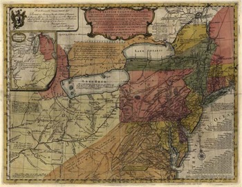
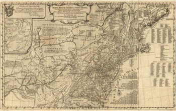
The story of how Amelia came to consider copyright as an option forms the basis of this article. A well-studied map with a little-known feature, A General Map of the Middle British Colonies, In America was the most famous text of Amelia's father, Lewis Evans's, career (Figure 1).Footnote 4 Published a year before his death in 1755, A General Map circulated widely around the British Empire throughout the second half of the eighteenth century, and has received considerable scholarly attention since.Footnote 5 It is a significant artifact in histories of cartography, commerce, business, science, and book history, and in studies of empire, colonialism, land speculation, and knowledge production. What has not yet been considered is how and why Lewis Evans, 30 years before any formal structures existed in North America, came to believe that he held some version of copyright in A General Map.
The first edition of A General Map, published in Philadelphia in June of 1755, in full color. The Library of Congress Geography and Map Division. G3710 1755 .E82.

The reason, this article argues, comes in two parts. The first lies in Lewis and Amelia Evans's unusual interpretation of copyright that pieced together several different stakes and debates around textual property, resulting in what I describe as “copyright consciousness.” Lewis and Amelia's legal consciousness, or “how people think about the law,” considered copyright and textual property distinctly in several respects.Footnote 6 In the eighteenth century, it was unclear whether or not “Acts of Parliament” involving copyright extended to the North American colonies, and there were no equivalent local laws in place until after independence. Further ambiguities existed about exactly what types of expressions, like maps, were eligible for copyright and on what terms. How Lewis and Amelia thought about and interacted with copyright did not necessarily align with the legal, political, and commercial standards of the time, but there were several key ingredients that signaled more collective understandings emerging decades later.
Given these ambiguities, understanding copyright consciousness in early America has historical and methodological challenges; namely, a lack of sources and formal documentation. Materials often associated with copyright, like courtroom records, contracts, and legislation, did not exist in this period, resulting in gaps in the historical record.Footnote 7 While Lewis and Amelia were not obscure figures, their circumstances as working writers as well as the broader realities of their class and gender left less evidence. Nonetheless, surviving fragments provide insight into how they interpreted copyright in relation to the broader jurisdictional problem embedded in the structure of empire itself: who got to claim a copyright, where, and from whom?
Lewis and Amelia's familial understandings of copyright—fragmented, contradictory, and complex—developed amid a central tension of governance in the British Empire, of whether or not rights guaranteed to British subjects extended beyond English soil. The second part of this article considers what this individual instance of copyright consciousness also tells us about how people like Lewis and Amelia understood jurisdictional intersection and separation in the British Empire. By taking English copyright conventions and applying them to colonial contexts, Lewis entered into the broader, percolating imperial conflict of what rights applied to whom and on what terms.
More than 30 years before laws were passed legitimizing intellectual property in North America, writers and mapmakers like Lewis were thinking about copyright. Lewis and Amelia's interpretations were not always consistent, and there are contradictions amid the remaining source materials. However, whether or not Amelia's and her father's interpretations were legally valid is not the focus of this article. That each believed that they had a copyright, or at least a persuasive argument for a version of one, is.
Components of Copyright Consciousness, 1749–56
While the divisions between British subjects and American colonists were less sharp than they became after 1763, the distinction was relevant to the copyright circumstances of A General Map. In a series of texts published in Philadelphia between 1749 and 1755, Lewis Evans produced geographic expressions that contained scientific and commercial data alongside political positions about local and imperial policies. To varying degrees, each of these publications—A Map of Pennsilvania, New-Jersey, New-York, And the Three Delaware Counties, A General Map, and its companion book, Geographical, Historical, Political, Philosophical and Mechanical Essays—were also artifacts of copyright consciousness.
The relevant English laws, The Statute of Anne in 1710 and The Engravers Act of 1735, were not clearly transferable to North American colonies. Nor were local policies established until after independence. Lewis therefore interpreted Pennsylvania and New York as separate spheres from London.Footnote 8 He did so through a series of creative choices that came to be materially embodied in his texts themselves. And yet, within his interpretation of copyright pluralism, Lewis also leveraged an understanding of English laws and commercial networks that extended his copyright consciousness as a British subject to imperial markets as well as to colonial ones. The result was a copyright consciousness that Lewis viewed copyright as simultaneously limited to different jurisdictions while also being relevant in both.
Lewis's copyright consciousness dually emerged from the specific stakes of what Oren Bracha, Mark Rose, and others discuss as the “literary property debate” in England and the broader challenge of competing imperial and colonial jurisdiction.Footnote 9 These two threads, of copyright and jurisdiction, were often intertwined in making geographic expressions. Lewis's interpretation of copyright practices were filtered through what Lauren Benton describes as “the portability of subjecthood and the delegation of legal authority,” where he had a dual awareness of copyright as a right for British subjects and the tension between Parliament and local colonial governance.Footnote 10 Portability and delegation resulted in “uneven imperial geographies,” which both influenced and were depicted in the content of Lewis's geographic expressions. They also provided the framework in which Lewis thought about and interpreted laws and practices involving copyright.
Dating back centuries, writers and booksellers deliberated whether some inherent form of ownership in texts existed, and if it was perpetual or limited. For a colonial subject like Lewis, either interpretation affected his publications, but ultimately the surviving evidence indicates that he and Amelia focused on a more fluid understanding of inherent textual property, further validated by statutory procedure but existing without it. Literary property predated formal structures of copyright, describing the product of a writer's intellectual or creative labor. However, what qualified as literary, and thus as property, was continuously debated alongside the question of whether it was tied to natural rights or to a short-term, positive recognition.Footnote 11 Amid a period of transition from one set of practices to another, the first copyright law, The Statute of Anne of 1710, was passed in response to the collapse of seventeenth-century government censorship and monopolies controlled by trade privileges.Footnote 12 The Statute of Anne granted any eligible text produced on English soil, namely books and pamphlets, 14 years of exclusive printing or reproduction rights, providing forms of recourse if there were unauthorized reprints or piracies of copyrighted texts.Footnote 13 The law was also referred to as “An Act for the Encouragement of Learning,” fusing the rhetoric of intellectual labor with public benefit.
Despite references to authorial labor and collective learning, The Statute of Anne resulted from the lobbying of the Stationers’ Company, a guild of booksellers and printers who had had, until the early eighteenth century, regulatory control over the book trade.Footnote 14 The primary holders of copyright, booksellers were proprietors who bought or acquired copyrights directly from writers, and were often at the heart of disputes. Stationers retained considerable power and were especially influential in overseeing the registration of copyrights, another contested element of English practices required to recover penalties.Footnote 15 The Entry Book of Copies of Stationers’ Company records do not indicate any colonial publication registered for copyright in London by an American.Footnote 16 No equivalent institution existed in North America.
The Engravers Act of 1735 provided a more direct blueprint for Lewis's copyright consciousness.Footnote 17 Expanding what forms of expression were eligible to include images, The Engravers Act recognized 14 years of exclusive rights to anyone who would “invent and design, engrave, etch or work…any historical or other prints.”Footnote 18 The Engravers Act emphasized language of artistic invention and creativity and because of the technology of reproducing prints, the plates that were used in the process were particularly important in denoting proprietary ownership.Footnote 19 Unlike acts pertaining to books, The Engravers Act did not require any registration in order to seek damages, but included a stipulation for the date of publication on the print and the owner's name. The result was a de facto form of copyright notice, which provided details about the publication, a form of paratext that resonated with Lewis.Footnote 20
Even though maps were a type of print, The Engravers Act of 1735 did not directly address them. It was not until the subsequent Engravers Act of 1767 that there was a clear extension.Footnote 21 Part of this owed to the difficulty of copyrighting maps, which as Mary Sponberg Pedley shows was “complicated by the very nature of the map itself: can one copyright geographical information depicting what is already in nature?”Footnote 22 There was a slowly emerging distinction in this period between what was expression and what was fact, as being the line between what is and is not copyrightable.Footnote 23 Geographic texts blurred those already fuzzy lines, particularly since maps were inherently collaborative to make. But as Isabella Alexander and Cristina S. Martinez explain, geographers based their reputations on “accuracy, scientific credentials, and objectivity” as opposed to authors or other artists, who produced “literary” or creative property.Footnote 24 In the developing public recognition of authors and literary property, it was ambiguous if mapmakers were the former and/or maps were the latter. Geographers like Lewis thus had to contend with complications around making any copyright claims, formal or otherwise. While The Statute of Anne and The Engravers Act were not definitive, each was practically limited to England given the location of the Stationers’ Company, other map guilds, and the court system. There are currently no known records indicating that lawyers, booksellers, or writers in England explicitly believed that that statutory copyright protection extended to the colonies.Footnote 25
These issues of what expressions copyright applied to, and where, shaped A General Map as a copyright artifact. The ambiguities, particularly around maps, afforded Lewis an opportunity to construct his own view as to how copyright related to colonial subjects.Footnote 26 His copyright consciousness contained several key ingredients, some of which were pulled from the literary property debates. Identifying as an author specifically, rather than an artist, Lewis first took an implicit position that there was some kind of inherent textual property in maps, property that could be passed on to Amelia after his death. Second, Lewis reinforced his position that maps were textual property by emphasizing his scientific and civic, rather than creative, authority, underscored through his expertise and labor. Third, in his dealings with printers and book and map sellers around the Atlantic, Lewis expressed deliberate legal knowledge that related to The Statute of Anne and The Engravers Act and other adjacent practices of contractual trade arrangements.
Lewis's copyright consciousness also developed closer to home amid the political and commercial circumstances of North America. Lewis's authorial authority drew on the skills and knowledge of others involved in mapmaking, particularly Indigenous people, to demonstrate the value of the texts, and, therefore, Lewis's value as a writer and geographer. Lewis also reinforced his reputation through colonial and imperial patronage. Tapping into political and commercial networks facilitated access to local institutions like the Pennsylvania government, where Lewis's labor was recognized and supported. In the transition from arbitrary sponsorship of creative productions to formal legislation that “encouraged learning,” grants that supported texts with allusions to social benefit vested A General Map with greater legitimacy. Rather than turning to institutions in London, Lewis first etched out a pluralistic view of copyright that functioned in separate jurisdictional spheres.
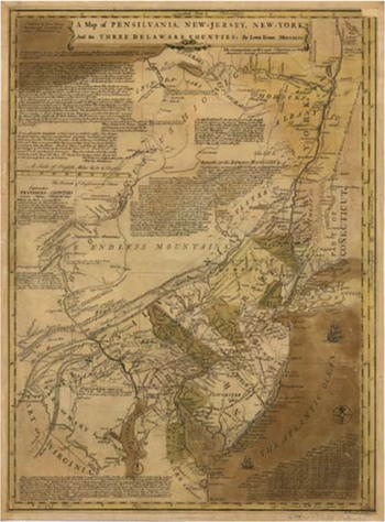
The ingredients that formed Lewis's copyright consciousness both built upon and broke from English practices. Lewis was born in Wales, emigrating to North America sometime in the 1730s. While either in Britain or in Pennsylvania, he became aware of copyright. Involved with the scientific community in Philadelphia, Lewis worked closely with Benjamin Franklin, who had his own extensive experiences with the book and print trades in London.Footnote 27 Whereas many contemporary geographers were either initially trained by or served in the British military or resided in London and relied on imperial archival records, Lewis was not a soldier surveyor. He honed his skills as mapmaker while also working as a draughtsman, a position that required design and legal skills. Draughtsmen “dr[e]w and copie[d] all sorts of maps, plans, sea-charts, prospects, and machines, with the utmost accuracy and exactness,” and also created legal documents.Footnote 28 Lewis's knowledge of copyright likely stemmed from these influences (Figure 2).
The first edition of A Map of Pensilvania, New-Jersey, New-York, and the three Delaware Counties, published in Philadelphia in 1749. The Library of Congress Geography and Map Division. G3790 1749 .E8.

Throughout his career, Lewis cultivated a reputation of expertise and authority that reinforced the authenticity of his expressions. His first effort in that process took place six years before the publication of A General Map. While Lewis may have been involved in mapmaking as early as 1737, his first printed publication was A Map of Pennsilvania, New-Jersey, New-York, And the Three Delaware Counties.Footnote 29 Brought about by travels to the Haudenosaunee capital of Onondaga in the mid-1740s, Lewis described, in the Pennsylvania Gazette, the “opportunity the Author has had of seeing and adjusting the vast Variety of Places and Materials entering into this Composition, his Accuracy, the Assistance he has received from of our Mathematicians, and his having his Map engraved by a good Artist, under his Eye, give us Reason to expect the Geography of these parts of America will be rendered sufficiently exact.”Footnote 30
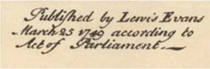
Whereas mapmakers’ authorial status was unclear in Britain, Lewis posited that he had some kind of textual property rights in A Map of Pennsilvania, New-Jersey, New-York, And the Three Delaware Counties. His position was made clear by the rare inclusion of copyright notice, or publication line. Similar to the © symbol today, located in the top left corner of the map was a clear paratextual statement, “Published by Lewis Evans March 25 1749 According to Act of Parliament”Footnote 31 (Figure 3). Lewis may also have put the notice there as a way to ward off reprinting, even if he knew it was not enforceable. Piracy was a term “used by printers and booksellers to denounce various activities that transgressed the shared norms of their community,” Will Slauter describes, but “these range of practices” were not all “illegal at the time.”Footnote 32 Since Lewis's copyright consciousness was informal, any concerns about piracy were also outside the bounds of oversight. It does not appear that Lewis negotiated an authorized English publication, nor does it seem that A Map of Pennsilvania, New-Jersey, New-York, And the Three Delaware Counties was entered at the Stationers’ Company or another mapmakers guild in London.Footnote 33 In this instance, Lewis mimicked the declarative statement of The Engravers Act but did not seemingly take his pursuit further than that.
The publication line or copyright notice of A Map of Pensilvania, New-Jersey, New-York, and the three Delaware Counties (figure three), located in the top left corner of the map adjacent to the cartouche.

It was one thing to say that you were an author of authoritative maps with a proprietary claim, but another to have others believe you. For this validation, Lewis turned to the Pennsylvania House of Representatives.Footnote 34 A Map of Pennsilvania, New-Jersey, New-York, And the Three Delaware Counties, containing “useful Remarks in Physics and Commerce,” was well received. In response, the Pennsylvania government ordered “that a present be made to him … in Reward of his Industry and Ingenuity in Making the said Map.”Footnote 35 Lewis's petition to the Pennsylvania House of Representatives nodded to older systems of patronage and to elements of copyright that became increasingly prominent after independence. Harkening back to The Statute of Anne's perhaps insincere but prominent emphasis on learning and collective benefit, “industry and ingenuity” reflected language circulating around textual property. A “present,” however, was more representative of the arbitrary nature of patronage, and so this language was indicative of a blend of older and emerging practices. The Pennsylvania House of Representatives was neither Parliament nor the Stationers’ Company. But it was a local governing authority that served as a source of recognition and sponsorship. Absent other institutions, turning to the Pennsylvania Assembly helped raise funds in an unstable and financially challenging profession while also drawing attention to Lewis's work. The different elements of Lewis's labor as a mapmaker—he was a geographer, surveyor, draughtsman—were all politically charged. For Lewis, his position as an American colonial geographer and a British subject were sometimes compatible and sometimes not, particularly when his copyright consciousness and textual property linked with views on imperial policy.
Amid the outbreak of the Seven Years War, Lewis sought to put each public or readership, imperial and colonial, in conversation with the other. In describing A General Map, Lewis acknowledged the “Assistance given him” to make a map “Designed intended for public Service.”Footnote 36 Echoing the rhetoric of public benefit embedded in The Statute of Anne and The Engravers Act, he continued, “Such assistance” was particularly necessary in America,” where a “European may be at a Loss to know.”Footnote 37
Lewis's copyright consciousness rested on this dual identity as an imperial subject and colonial geographer. On the one hand, A General Map was, Martin Brückner notes, “a thoroughly local product incorporating eyewitness accounts and personal surveys, colonial artisanship and civic patronage.”Footnote 38 On the other, imperial policies influenced its creation. For example, Lewis's stated goal of A General Map was “render[ing] this map useful in Commerce, and in ascertaining the Boundaries of Lands.”Footnote 39 Initially, Lewis appeared to envision the map for military use, or for the patronage of the Pennsylvania or Maryland proprietary families. Commerce and the boundaries of land were deeply interwoven, inseparable from the politics of imperial expansion.Footnote 40 The very notion of public domain or public dominion is reflective of space—intellectual or physical—that cannot be claimed by one specific person.Footnote 41 The British imperial project advanced the opposite logic, that property was property and needed to be owned and controlled by someone: in this case, the crown and Parliament.Footnote 42
At 50 by 67 cm, A General Map blended pictorial images, topographical renderings, and extensive verbal descriptions.Footnote 43 These included infrastructural and natural resource observations, such as of coal, limestone, petroleum, elephant bones, and pathways and illustrations of topographic formations, currents, and other land formations. The paratextual verbal descriptions contained the most vivid evidence of Lewis's copyright consciousness. Some of these elements were less direct, highlighting the contextual components that shaped Lewis's perspective, while others were lifted from the pages of English law, quite literally, and given a distinctive, colonial spin.
Both the local and imperial dimensions of A General Map were centered in several aspects of the text, particularly in the title. The first portion emphasized British presence: A General Map of the Middle British Colonies, In America; Viz Virgina, Mariland, Delware, Pensilvania, New-Jersey, New-York, Connecticut, and Rhode Island. The second part, Of Aquanishuonigy, the Country of the Confederate Indians, Comprehend Aquanishuonigy proper, their Place of Residence, Ohio and Tiuxsoxruntie, their Deer-Hunting Countries, Coursaxrage and Skanladarade, their Beaver-Hunting Countries; Of the Lakes Erie, Ontario and Champlain, And of Part of New-France: Wherein is also Shewn the Ancient and Present Seats of the Indian Nations, acknowledged Indigenous sovereign territory and knowledge of that space.
Referencing and incorporating Indigenous knowledge was one of several strategies that Lewis deployed to emphasize the Americanness of A General Map, which helps explain his divergent understanding of copyright. The extensive influence of Indigenous knowledge on European and American media and information networks, especially in maps, was present in all of Lewis's works.Footnote 44 Referencing Native knowledge buttressed Lewis’ own expertise and singled the significance of A General Map as an American, rather than an English, product. As a colonial expression, A General Map supported a British imperial project but also implied a different perspective than texts made in London. This in turn made it more compelling to both publics for different reasons. In America, A General Map had day-to-day uses whereas in England it could satisfy anything from reader curiosity to political or commercial planning.
Access to Native knowledge enhanced both of these applications. “For want of Room in the Plate,” Lewis Evans wrote Geographical, Historical, Political, Philosophical and Mechanical Essays, frequently referred to as the Analysis for short.Footnote 45 A collection of companion essays, the Analysis provided supporting details about A General Map and occasional insights into how Lewis thought about his work. In the Analysis, Lewis repeatedly referred to geographers and mapmakers as authors, remarking how “the present, late, and antient Seats of the original Inhabitants are expressed in the Map,” details that other “Authors, for Want of Knowledge in Indian Affairs,” failed to depict accurately.Footnote 46 The claim to knowledge of “Indian Affairs” set A General Map apart from other publications.
In the Analysis we learn of one specific Indigenous guide, referred to as “The Eagle,” whom Lewis likely met in travels to Onondaga. Lewis praised The Eagle's praised “intelligence” and knowledge of the region, alongside several other unnamed Indigenous experts. Fitting with the commercial agenda of A General Map, Lewis emphasized The Eagle's “good Notion of Distances, Bearings and delineating” to further enhance the quality of his own visualizations.Footnote 47 Lewis likely credited The Eagle to reinforce his own knowledge by proxy, but did not foresee any proprietary dimensions in doing so.Footnote 48 The distinction of “composing” as the “skilled practice of a scientist, distinguishable from discovery in nature,” Anjali Vats argues, evokes a “framework of expertise” deployed to “exploit traditional knowledge for its commodity value” while refusing to recognize that knowledge as a form of intellectual property.Footnote 49 Like the existing complications of copyright in maps, specifically the tension between parallel claims of factual representation and expression, Indigenous guides and the sharing of cartographic information were not recognized as proprietary beyond whatever agreements were made during travel.Footnote 50
While Lewis's relationship to The Eagle does not reveal a new aspect of Indigenous knowledge production, it does demonstrate how copyright consciousness in America depended on Indigenous intellectual contributions.Footnote 51 Lewis leveraged Indigenous knowledge in construction a proprietary claim based not on creativity but expertise and labor. Mirroring these contradictions, A General Map was equal parts “a statement of imagined usurpation and the product of collaboration with native people.”Footnote 52 Moreover, Lewis's reliance on contributors like The Eagle underscores the inherently collaborative nature of mapmaking.
In addition to Indigenous experts, Lewis worked closely with Thomas Pownall, Franklin, and another protégé of Franklin, James Turner. Turner was a silversmith who began working with maps as an engraver in the mid-1740s. There were not many well-known engravers in North America in this period, given the expenses involved, but Turner achieved some prominence through several commissions from Franklin.Footnote 53 From a certain angle, The Engravers Act could have vested some form of copyright with Turner rather than Lewis. But since A General Map was “cause[d] to be designed and engraved” by Lewis Evans's “own Works or Invention” rather than drawn by Turner himself, Lewis considered himself to be the primary creator.
Referencing contributors like Turner, the engraver “in Philadelphia,” enhanced the prestige of A General Map while also nodding to the copper plates that made it, technological components so integral in establishing copyright claims. Lewis dedicated A General Map to Thomas Pownall, who ultimately facilitated Amelia's copyright claim decades later.Footnote 54 “By including the dedication, Lewis sought to “reassure the Public, that it has past the Examination of a Gentlemen who I esteem the best Judge of it in America.” Pownall was a bureaucrat who was well known in England but unusually popular in America. The dedication emphasized Lewis's proximity to power in the metropole and to expertise in the colonies while also promoting Pownall's reputation.
Lewis deployed paratextual elements, from the cartouche to the dedication, to evoke both an imperial imaginary and his status as an expert author. These became tied to copyright and jurisdiction directly in another element of A General Map: the copyright notice. In the bottom right corner the map is an easy-to-miss paratextual statement: “Published according to Act of Parliament by Lewis Evans, June 23 1755 and sold by R. Dodsley in Pall-Mall, LONDON, & by the Author in PHILADELPHIA”Footnote 55 (Figure 4). “Published” by or according to an “Act of Parliament” were variants on the English copyright notice that also referenced The Engravers Act, which required any proprietor to state the date of publication along with identifying information in order to recover damages. A General Map's notice included additional details that evoked copyright statutes: the “Act of Parliament,” and “according” to its terms. Lewis described himself clearly and directly as an “author,” even though maps’ eligibility for copyright and property were contested ideas in the 1750s and 1760s. This choice evoked the language of both ownership and recognition. Rather than noting a book or map seller in Philadelphia, like Franklin, Lewis stated that A General Map was sold by himself.
The publication line or copyright notice of A General Map (figure two), located in the bottom right corner of the map.

Including a copyright notice in A General Map, one far more detailed and descriptive than in A Map of Pennsilvania, New-Jersey, New-York, And the Three Delaware Counties, reveals Lewis's growing interest in copyright. What the statement meant beyond that is more complicated. Lewis boldly claimed that A General Map was “Published according to Act of Parliament,” a clear reference to The Engravers Act. What comes after “Published according to Act of Parliament,” however, points to different possibilities. Lewis included two commercial jurisdictions in the line, saying that the map could be purchased from the London-based bookseller, Robert Dodsley, or from “the Author” in “PHILADELPHIA.” But did Lewis mean that he believed The Engravers Act extended to Philadelphia, or that he had some kind of inherent textual property in A General Map and was following the language of recognition?
In extending copyright and authorship to maps, Lewis interpreted The Statute of Anne's emphasis on authorship and The Engravers Act's focus on prints differently from his peers in London, while still recognizing parliamentary authority. But even though he referenced The Engravers Act, it did not necessarily mean that the precise provisions of the law applied in Philadelphia. As Christian Burset notes, common law was “selectively transplanted,” and Lewis could have understood textual property as being something that existed across the empire, even if the structures that enforced it did not.Footnote 56 The practicalities of transatlantic copyright would have been extremely challenging, hence Lewis's inclusion of a London book and map seller like Dodsley. Given these ambiguities, it is also possible that when confronted with new challenges or circumstances between June of 1755 and his death a year later, Lewis simply changed his mind. If nothing else, more deliberately than out of simple mimicry, Lewis included the detailed notice to ward off would-be copiers in England, perhaps anticipating that a different version would be eligible in London and thus avoiding the need for multiple plates or designs.
No explicit sources survive where Lewis clarifies his logic around the copyright notice. Other evidence—government petitions, letters and correspondence, other published works, and Lewis's own will—indicate that he viewed London and Philadelphia as two distinct jurisdictional and commercial spaces. In other words, Lewis took aspects of The Engravers Act, inferring that it was neither enforceable nor directly applicable to colonial writers, and patched together a local version distinct from a formal copyright in London. Differentiating between “those in power” in Britain and in “the Colonies,” Lewis described how he had rushed A General Map's publication because of changing circumstances and “British and French policy” claims to the Ohio River Valley.Footnote 57 In the spring of 1755, Pennsylvania Governor Richard Hunter Morris and General Edward Braddock received copies with the explanation that Lewis was working hard to complete it. Braddock's draft of A General Map, likely on his person when he infamously failed to capture the French Fort Duquesne in the summer of 1755, was nearly complete, save for the copyright notice. In the bottom right corner, the manuscript read, “Lewis Evans By Forthwith, May 6th, 1755.”Footnote 58 Even though the notice was not fully articulated, Lewis still signaled that the space was for the forthcoming details.
Franklin, Lewis's Philadelphia printer, unnamed in A General Map, seemed to agree with him, as his later dealings with Amelia indicate.Footnote 59 Breaking from the common British practice of a bookseller rather than a writer or an artist holding a copyright, Franklin did not pursue copyright in his own endeavors. But he was certainly aware of its existence and shared what he knew with Lewis and later with Amelia.Footnote 60 Franklin published reprints of English books, lending further evidence that Lewis and Franklin believed that copyright law did not extend to Pennsylvania.Footnote 61 This did not mean, however, that it could not exist in some form in North America parallel to or even independently of British oversight.Footnote 62
To cultivate local government support, Lewis Evans foregrounded the idea of public benefit alongside personal labor. Lewis praised “the Encouragement of a Body who devote the Public Money to the Public Service,” a body that resided in Philadelphia and not London.Footnote 63 This was a practical choice as much as a political one: it was much easier to appeal to the Assembly, particularly when he did not have the same relationships in London. Nonetheless, the emphasis on his labor and effort echoed those same far-away statutes, applied abstractly if not materially, in North America.
Having completed the bulk of the work on A General Map by 1754, Lewis needed additional funds, and turned to the Pennsylvania government for support.Footnote 64 His request to the Assembly stated that since Lewis was “unable to support the Ex-pence of Engraving and Printing the said Map, and of printing an Analysis containing his Authority,” he “prays that this House would grant him such Assistant in the Premises, as to their Wisdom shall seem meet.”Footnote 65 Since A General Map and the Analysis were considered useful to the public, the Assembly gave Lewis £50 in recognition of his “labour and expence” and to “better complete and publish” what would be necessary to offset the “Ex-pence of Engraving and Printing the said Map, and of printing an Analysis containing his Authority for every Part thereof.”Footnote 66
These successful appeals further validated Lewis's ownership claim over the map. Once again, Lewis emphasized the American-ness of A General Map through petitions to a local official institution. In contrast with another celebrated map of the period made by John Mitchell, Lewis described how his “labour” included extensive time traveling in North America to produce a map for people who lived there.Footnote 67 Support from the Pennsylvania government validated his claims of labor, expertise, and public utility, vesting Lewis with civic rather than creative authority. The Pennsylvania government's sponsorship of A General Map and the Analysis harkened to traditional forms of patronage for artists and scientists, categories that to an extent, Lewis sought to merge with copyright under the banner of authorial authority. But authority, as presented in the Assembly records, simultaneously validated the Assembly's prerogative to provide that support in the first place.
Such a grant was indicative of the rhetoric of copyright consciousness, past and future, and how it related to government authority to promote works with perceived social value. Franklin observed the role of the Assembly, writing “We have a new Map going forward” which “the Assembly have to encourage him given £50 towards the Expence.”Footnote 68 The “encouragement of a body,” Lewis himself described, was not dissimilar to the stated intention of The Statute of Anne, “An Act for the Encouragement of Learning” and The Engravers Act, “An Act for the encouragement of the arts of designing, engraving, and etching historical and other prints,” or even the first nationwide law in North America, The Copyright Act of 1790 or “An Act for the encouragement of learning, by securing the copies of maps, Charts, And books, to the authors and proprietors of such copies, during the times therein mentioned.”Footnote 69 The language of encouragement incentivized writers and artists, and reflected government ability to support publicly beneficial intellectual labor.Footnote 70
By the end of 1755, Lewis Evans's copyright consciousness culminated in implicit understandings of textual property in Philadelphia and explicit interpretations of it in London. Based on the surviving evidence, Lewis was interested in English options from the early days of his writing and map making, but saw them as distinct from North American ones.Footnote 71 Perhaps even prior to his 1749 map, Lewis was in contact with Robert Dodsley in London about methods to publish his work most effectively in England. As Lewis referred to Dodsley as a friend in his will , we know at the very least that between the manuscript reference to “by forthwith” in May of 1755 and the inclusion of Dodsley in the copyright notice a month later, some plans were in place. A close reading of the use of “saving” the benefit of copyright implies that Lewis thought that something had been lost. Whatever he may have though in June of 1755, by the winter of 1756 he no longer thought the American printing of A General Map would be protected under English laws.
Lewis's letter to Dodsley presents the strongest argument that The Engravers Act did not formally extend to the colonies and that Lewis was in essence on his own in trying to piece a form of copyright together. Lewis began negotiating an authorized, British edition of A General Map with Dodsley. Lewis wrote extensively of his present political circumstances and how they were connected to A General Map's popularity. Embroiled in tensions over French treaty negotiations, border disputes, Indigenous diplomatic policy, and arguments between the colonial proprietors and assemblies, Lewis was accused of defamation by Governor Hunter Morris, and fled to New York.Footnote 72 That Lewis had better relationships with colonial officials, or popular imperial ones like Pownall, contextualizes why his copyright consciousness considered London and Dodsley as distinct from Philadelphia and Franklin. For example, The New York Mercury's critique of Lewis's positioning of boundaries demonstrated the deeply political and commercial interests in textual depictions of land ownership and the risks geographers like Lewis took.
At the core of the controversy was whether or not A General Map was sufficiently pro-British in its depictions of these competing land claims. Again blurring the line between factual depictions and interpretative expression, maps and accompanying commentaries could be manipulated toward a desired political outcome, and the writer of the letter in The New York Mercury was aware of Pownall's relationship with Lewis.Footnote 73 There was also the additional complication of property: Lewis's copyright consciousness in North America was predicated on functioning separately from London and having some degree of ownership over his texts. Since A General Map was used for settling boundary disputes, when Lewis determined certain land to be the dominion of the French or of Indigenous nations and communities, critics reacted intensely.Footnote 74
Public exchanges about Lewis's views on French–British conflict culminated in Lewis's arrest in New York City for libel in 1756.Footnote 75 Lewis's carefully cultivated reputation was directly under attack. Before his incarceration, he encouraged Dodsley to get a formal copyright and make a new version of A General Map, because Lewis had serious concerns about A General Map being “pyrated in England.”Footnote 76 Such a charge of piracy again indicated that Lewis believed that he had some form of proprietary rights to his work, whether or not those were legally valid. In addition to selling “a Box of Maps, containing 24 coloured Maps & 6 plain ones bound in the Pamphlets, which are all I can spare till I get Paper from Europe,” Lewis sought to produce a second, authorized London edition with Pownall acting as a go-between.Footnote 77
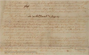
A second edition could theoretically be eligible for more formal protection: although Lewis did not live in England, he was a British subject, and the second edition would be made in London rather than Philadelphia. “It may be done, as by my Assignment, (which if Mr. Pownall and you come to an Agreement, I will send you duly executed)” he wrote, “to save the Benefit of the Act of Parliamt.”Footnote 78 Demonstrating an awareness of the relevant laws in England, Lewis's skills as a draughtsman were as relevant to the planning as his being a geographer. Should A General Map be produced in England, it would be eligible for the benefit of copyright. For this reason, Lewis concluded, a second, authorized edition, must not “be sent for Sale to America,” where it would compete with the first American edition, undermining his textual property in Pennsylvania.Footnote 79 This required two maps, two copyrights, and two jurisdictions (Figure 5).
Lewis explicitly addressed “the Act of Parliament” towards the end of his letter to Robert Dodsley. Underlined for emphasis. The Library of Congress. Lewis Evans correspondence, 1756. mm 79004680.

Lewis's letter to Dodsley demonstrated that he believed that he had separate, plural ownership of his maps in North America and in England, even if we cannot be sure as to how that would have functioned. Walter Klinefelter determined that “Pownall does not appear to have concluded an agreement with them [Dodsley and his son] or with any other London publishers.” If Lewis had been able to advocate for himself, Dodsley may well have followed more formal channels in London. But given Lewis's death and the limited provenance of his letter, we can only speculate as to what might have happened next if the proposed edition had come to pass under these terms.Footnote 80
An authorized, second London edition of A General Map was eventually published in the winter of 1776. It took decades longer than expected and resulted from extensive efforts by Amelia rather than her father. Lewis never went to trial, but was held in prison for several months on ambiguous charges of libel. When his health so declined to the point that it was clear that he would not survive, he was released only to die several days later. With all thoughts directed toward his soon-to-be orphaned daughter, Lewis charged Pownall with advocating for Amelia's textual property in England while Franklin would do so in America.Footnote 81 In the final evidence of Lewis Evans's copyright consciousness, his plans shifted from the “Act of Parliamt” to what benefits it might eventually provide his daughter.
Claiming Copyright Across the Atlantic, 1766–81
In the decades following Lewis's death, Amelia pressed her claim to A General Map through multiple channels, creating a genealogy of copyright in the process.Footnote 82 It was only until two issues that complicated her father's experience were resolved that she was able to move forward. When an authorized reissue of A General Map called A Map of the Middle British Colonies was published in 1776, it was eligible for copyright because it was printed in London and the 1767 revision of the Engravers Act included maps. Such eligibility reveals how prescient Lewis's copyright consciousness was, shared within the people closest to him. Amelia's continued focus on an inheritable textual property in A General Map also points to an interpretation of copyright that both traversed and was limited by jurisdictional boundaries.Footnote 83
Published on the eve of the American Revolution, A Map of the Middle British Colonies was promoted concurrently as a product distinct that was distinct, yet equally as authoritative as the original. Amelia, Pownall, and others involved struck a balance between emphasizing A Map of the Middle British Colonies's connection to its predecessor and presenting the second edition as being different enough to constitute a new expression. They did so by accentuating how several features of Lewis's copyright consciousness in the 1750s remained relevant: scientific expertise and authority, civic and public value, and authentic, rather than unauthorized, labor were all brought to bear. Amelia and Pownall struck a balance between their rights as proprietors rather than “authors,” and Lewis's contributions as a geographer, bridging the two largely through rhetoric of improvement and recognition. The intended audience, unlike for the first edition, was explicitly imperial and thus public opinion in London was courted in deliberate ways. Both the first and second editions of A General Map did not necessarily align fully with official terms of copyright, but rather, in Pownall's own words, addressed “the spirit of Copyright” instead.Footnote 84
The “spirit of copyright” was, in this instance, about directing the benefit or results of Lewis's labor to Amelia, unobstructed by unauthorized reprintings. Resolving the tension between her rights as a British subject and her residence in North America, the second edition drew upon the terms described in Lewis's will that sought to resolve the issue. Lewis left his property, “whether real or personal,” to Amelia and her heirs.Footnote 85 Martha Hoskins, Amelia's mother, predeceased Lewis by two years, and given Amelia's young age, she was not yet married, thus avoiding the issue of coverture and familial (intellectual) property.Footnote 86 “Lewis appointed his brother John and friend William Coxe as his executors.Footnote 87 Among this property were the copper plates of A General Map, an essential technology to ensuring a copyright claim for prints.
For Lewis to leave the plates and prints of A General Map to Amelia in perpetuity meant that he believed that he had some kind of perpetual right to them. The connection between the copper plates and the resulting texts materialized the claim by ensuring that Amelia would have a practical way of controlling how future copies were made. Looking backwards and ahead to another edition of A General Map, Lewis elaborated on his plan with Dodsley and how it should benefit Amelia. On “January 24th, 1756,” Lewis described, “I empowered Mr. Thomas Pownall to treat with my friend Dodsley in London about reprinting my general Map and promised to execute a Deed to confirm the agreement they should make.”Footnote 88 “If such a Deed is sent after my death,” Lewis continued, “and the Tenour of it be Lawful and reasonable I do hereby confirm the same.”Footnote 89 Any “profits that shall accrue on such Deed and contract” he stipulated, belonged to Amelia, and her descendants. While not the same thing as a formal copyright—again, it was unclear as to whether maps were eligible, even in England, in 1756—such an agreement echoed features of Lewis's copyright consciousness, particularly the request to “save the benefit of the Act of Parliamt.” The contract with Dodsley to reprint A General Map in London reaffirmed that whatever form such a copyright took belonged to Amelia and her children.
In a microhistory in which the limited existing sources speak often to male figures, property, and governance, the copyright consciousness of these texts makes clear that those histories are also fundamentally Amelia's. Her role in the story of A General Map was as a proprietor, specifically once she turned 16 years of age. Before then, such rights and property were overseen by her uncle and Coxe. Because Amelia controlled the copper plates of A General Map, she had the ability to back up what her father had left to her.Footnote 90
Amelia's life was, as was the case for many orphaned children through the present day, traumatic and financially precarious. She lived first with her uncle John Evans until his death in 1759, then under the guardianship of John Gay, spending considerable time with Deborah Read Franklin, her godmother.Footnote 91 Around 1762, Amelia traveled to England to continue her education and work as a governess for the family of James Traill, the British consul-designate in Tunisia. Amelia was interested in ancient history, and through that interest struck up a friendship with a young Thomas Erskine, Thomas Paine's future libel lawyer. Franklin described Amelia as a “great Traveller,” who went to all corners of the world, and he facilitated several introductions for her once she left Philadelphia.
Amelia never returned to North America, and the copper plates of A General Map as well as of A Map of Pennsilvania, New-Jersey, New-York, And the Three Delaware Counties went with her to England.Footnote 92 A version made in England made a stronger case for copyright, and Amelia was aware of this from the time she left Philadelphia. Needing funds prior to her departure in February of 1766, Amelia arranged to use the plates of A General Map and the “Right to the Copy” of the companion book as collateral for a loan from Franklin.Footnote 93 When she began her travels around Europe and Asia, Amelia left these materials behind in London with Franklin; they eventually passed on to Pownall.
Amelia's career as a writer began during this period, and she was sharply aware of the importance of creative as well as financial autonomy over authorial work. While working in Tunis, Amelia met her husband, David Barry. Born in Ireland, Barry was involved in the Levant, or Eastern Mediterranean, trade, and he and Amelia spent considerable time in Tunisia, Turkey, Greece, and Italy. Marrying in 1770, Amelia had five children born on four continents and was frequently short of money. She learned early the precarity of intellectual labor and the necessity of structures of support in order to ensure that writers, teachers, and artists could provide for themselves.
Amelia's framing of copyright consciousness was vivid in her correspondence with Franklin. Consistently trying to arrange stable employment for her husband and education for her children—including her daughters—Amelia pursued sources of support in multiple locations.Footnote 94 Her sympathy to United States independence, reflected in comments about “my country,” were at odds with those about “necessary regulations of a great Commercial Empire whose views must extend to every part of the World.”Footnote 95 In 1778, she drew attention to government support of her father's map, suggesting that its civic value was something that she also saw as inheritable. She imagined that Congress “cannot then be unwilling to preserve his only remaining descendant from indigence.”Footnote 96
Emphasizing the history of how A General Map was made in North America, Amelia pursued channels for compensation in the Continental Congress and in London. It was the pursuit of the latter that prompted her grief-stricken letter to Franklin in 1781. That message came on the heels of nearly 4 years of waiting for the profits of A Map of the Middle British Colonies to materialize. In March of 1775, Pownall re-entered the story by obtaining the “broad Copper Plate” and “one of the Prints” from Franklin's hastily vacated London residence.Footnote 97 Amelia and Franklin were in conversation about the Barrys’ challenging financial state, and Franklin coordinated with Pownall to assist. A General Map's plates were in London for nearly a decade, but there is no record in the Stationer's Company logs that Pownall made any effort until entering into production on a revised version of A General Map. Since Pownall ignored his promise to Lewis and largely neglected Amelia after her father's death—Amelia thanked him for the support but not without observing that she “did not believe that he recollected my ever having had an existence”—he decided to revise A General Map and create a new edition at Amelia's behest.Footnote 98
It was Pownall and not Amelia who was credited in A Map of the Middle British Colonies.Footnote 99 John Almon, the printer and bookseller, took charge of the production while Pownall identified himself an editor. “Printed & published according to Act of Parliament” for book and mapseller “J. Almon” was front and center in the cartouche. Replacing statements of Indigenous sovereignty with statements of imperial ownership, where the “ancient and present seat of Indian nations” was once centered, Pownall instead positioned a copyright notice. Book and map sellers continued to hold copyrights during this period, so Pownall and Almon followed common practices, despite the agreement that the proceeds belonged to Amelia.Footnote 100 Framing Amelia's involvement in philanthropic rather than contractual terms, Pownall wrote that any profit that “should accrue … will be given to Mr. Evan's Daughter or her Children.”Footnote 101 Drawing on notes that Lewis recorded before his death, which do not survive, Pownall also published a companion book, A Topographical Description of Such Parts of North America As Are Contained in The (Annexed) Map of the Middle British Colonies, &c, In North America.
Revising the title as A Map of the MIDDLE BRITISH COLONIES IN NORTH AMERICA. First Published by Mr. Lewis Evans, of PHILADELPHIA, in 1755; and since corrected and improved, as also extended, with the Addition of NEW ENGLAND, and bordering Parts of CANADA: from ACTUAL SURVEYS now lying at the Board of Trade, Pownall simultaneously emphasized how A General Map was appropriated by London map sellers while avoiding a similar charge of appropriation himself (Figure 6). Describing A Map of the Middle British Colonies as an improvement rather than a reprint, Pownall lambasted booksellers and mapmakers who had reprinted or repackaged A General Map without permission.Footnote 102 The “Pirated Copy of this Map,” he fumed, “came to England, [and] was in a most audacious Manner published by the late Thomas Jefferys, under a false Pretence of Improvements.”Footnote 103 Pownall was enraged that Jefferys, official geographer to the Prince of Wales and one of the best-known mapmakers of his day, was making copies that Pownall found to be illegitimate.Footnote 104
The first authorized revised edition of A General Map, retitled A Map of the Middle British Colonies in North America, published in London in 1776. The Library of Congress Geography and Map Division. G3710 1776 .P61.

The public tension between Pownall and map sellers like Jefferys hinged on Lewis's copyright consciousness, particularly the aspects of civic value and authorial reputation. Whether or not “blundering copyists” were legally allowed to “improve upon” or outright reprint maps made in North America or down the street in London, in the 1750s, was not Pownall's focus.Footnote 105 Pownall believed that Lewis's labor and authority as a geographer gave him an inherent right to A General Map. Given Lewis's “scrupulous Caution not to deceive,” he had produced an authentic text with civic value.Footnote 106 The “pirated Copy” was “so totally ignorant of the Principles on which the Original was Formed,” that it resulted in a publication that was riddled with errors and besmirched Lewis's name.Footnote 107 Moreover, Pownall continued, when Lewis's “Name [was] put to it,” readers had a misleading sense of his involvement. “This Plagiarism was falsely sold as Evans's Map improved,” Pownall concluded, “by which that very laborious and ingenious, but poor Man, was deprived of the Benefit of his work.”Footnote 108
Even if such maps were legal, Pownall argued, they undermined the encouragement or benefit that copyright was supposed to provide. In reprinting A General Map without permission or compensation, Pownall wrote, “neither the Eye, the Ideas, nor the Spirit of the Copyright went to Making this; and all Parts stand equal in Authority in his false Copy.”Footnote 109 This framing spoke directly to Lewis's copyright. While A General Map was realistically not protected under English laws, it was nonetheless a form of textual property that benefited Lewis as a writer and geographer and “encouraged learning” amid broader publics.
While the proceeds of the 1776 edition were designed to restore the benefits from whatever form of copyright Amelia successfully argued that she had, she faced obstacles in actually getting any money from Almon.Footnote 110 Since he was the stated copyright-holder, Amelia had to rely on informal agreements to get what Almon owed her. Writing to Franklin, she asked for “an order upon Govr. Pownal or Mr. Almon for the payment of such profits as may have arisen from the Sale of the Map & Pamphlet.” While she had initial updates, Amelia struggled to receive the money.Footnote 111 Franklin had to intervene several times, especially when Almon tried to avoid giving Amelia the £29.50 he owed her. Almon eventually made good on the modest payment, but the stress in obtaining the funds is illustrative of how unstable these proprietary arrangements were, particularly for women, who had to tolerate others acting in their name.Footnote 112
Almon's delays may have prompted Amelia to use a different printer when she published a subscription anonymous novel, Memoirs of Maria, a Persian Slave, 1790, in London while living in Livorno. A fictionalized account of an enslaved woman of Middle Eastern descent, the novel reflected Amelia's time living in Turkey as well as her ties to the Mediterranean merchant community.Footnote 113 This is the only surviving text currently attributed to Amelia, but there were others written in the 1780s, anonymously, which either are not definitively corroborated or do not survive.Footnote 114 Living abroad until shortly before her death in England in 1835, she remained close to Pownall and Franklin. As Franklin leveraged the copyright and plates from her initially, he and Pownall recognized the principles of her claim and supported it. Whether that was driven by copyright consciousness or remorse for what had happened to her father, we can only speculate.
Produced in England where maps were by then covered by copyright, A Map of the Middle British Colonies addressed two of A General Map's challenges, one of jurisdiction, the other of expression. In doing so, the publication campaign around A Map of the Middle British Colonies validated Lewis's and Amelia's copyright consciousness, transported quite literally across time and space. The legacy of Lewis's copyright consciousness blended an interpretation of maps as textual property, framed by English laws like The Engravers Act but applied to colonial jurisdictions, with a cultivation of authority and ownership grounded in geographic labor and reputation. As Pownall himself wrote during this period, there was a “spirit of copyright,” not unlike copyright consciousness, which held sway.
While the formal copyright obtained for A Map of the Middle British Colonies followed the standards of English law and practice, A General Map complicated those categories. A legal, political, commercial, and family history, what Lewis pieced together about copyright in the late 1740s and 1750s and passed on to Amelia was fragmented and ambiguous, a product of the limited surviving evidence grounded as much in the realities of Philadelphia as in those of London. In applying copyright to North America, Lewis engaged in elements of extra-legal imitation, but the performance of copyright was no less significant because it may not have been legally valid. Reinforced by a pluralistic perspective, Lewis's copyright consciousness at once drew on traditional copyright parameters and reframed them. In doing so, Lewis's claims to textual property echoed the central fault line of eighteenth-century empire, one centered on the issue of who was included in the rights of subjecthood, including a right to make copies.
Acknowledgments
Thank you to the editor of the Law and History Review for his support and encouragement, and the anonymous reviewers for their comments. Versions of this article were shared at the McNeil Center for Early American Studies Friday seminar, the Writers Bloc legal history group at the University of Pennsylvania, the Yale Early American History (YEAH) seminar, the Stanford Center for Law and History, the Columbia Journalism School Colloquium, and the City University of New York (CUNY) Graduate Center Early American Republic (EARS) seminar, and each community provided tremendous feedback. All my thanks to Isabella Alexander, Cristina S. Martinez, and Mary Sponberg Pedley for their patience and generosity in answering numerous questions. Richard H. Brown and Michael McNamara also shared key sources with me: my thanks to them as well. Lastly, Mark Boonshoft, Lauren Duval, Hayley Negrin, and Kara Swanson read and responded to multiple drafts of this article, and it would not be published without their insights. Due to the limits of space, there are also several other institutions and individuals who made research for this article possible that I instead acknowledge throughout the notes. All figures in this article are from the Library of Congress.