
Introduction
The history of Ethiopia between the fall of the kingdom of Aksum (seventh century AD) and the rise of the Zagwe Dynasty (eleventh to late thirteenth centuries) remains clouded in obscurity. Very little is known about the shift that drove royal power southward, or about the Christianisation that occurred during this period. This gap makes questions related to Lalibela—the famous complex of rock-cut churches in the central Ethiopian Highlands—all the more important. What was the significance of this southern region for the kingdom of Aksum and the Zagwe Dynasty, and what was its cultural environment? Why was the site of Lalibela chosen as the kingdom's spiritual centre during the reign of the sovereign of the same name (c. AD 1204–1225)? Was it also a royal residence?
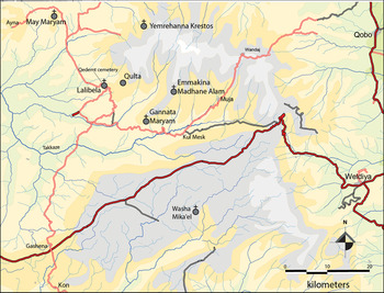
The only extant documents from the reign of King Lalibela comprise a few land grants copied in manuscripts and inscriptions on altar stands, which are still kept in churches at the site today (Bosc-Tiessé Reference Bosc-Tiessé2010; Derat Reference Derat2018: 29–86). Thus, while these small documentary windows enable us to confirm that at least some of the site's churches were in existence in the thirteenth century, they contribute little to answering the questions raised above. Two recent investigations, comprising excavations of the spoil heaps at Lalibela and the study of the nearby rock-cut site of Washa Mika'el, have illuminated the region's pre-Christian environment, the modalities of its Christianisation and the continuation of non-Christian elements in the region (Figure 1). Regarding this cultural ‘substrate’, it seems that rock-cutting building techniques were of major importance. These two sites enable us to clarify the relationships between rock-cut and built structures, and to study how different cultures occupied the landscape.
Map of Lalibela, Washa Mika'el and other rock-cut sites in the vicinity (map from Ege (Reference Ege2002: pl. 25), adapted by M.-L. Derat/Lalibela Mission).

Rock-cut sites are numerous in the northern half of Ethiopia, and churches have formed a particular focus of research (e.g. Buxton Reference Buxton1946; Sauter Reference Sauter1963, Reference Sauter1976; Tewelde Medhin Reference Tewelde Medhin1970; Lepage Reference Lepage1972, Reference Lepage1973; Lepage & Mercier Reference Lepage and Mercier2005; Phillipson Reference Phillipson2009). These churches have generally been interpreted through the lens of their presumed function, during the initial phase of Christianisation, for funerary purposes (Lepage Reference Lepage1972: 196, Reference Lepage1997), while others were for eremitical use (Anfray Reference Anfray1985: 33; following Matthews & Mordini Reference Matthews and Mordini1959: 48–49). Scholars, however, have overlooked the possibility that the chambers may have been cut for non-religious reasons. As early as the 1520s, the Portuguese priest and diplomat Francisco Alvares evoked the troglodytic practices of “a country of pagans called Gorages”—a cultural group occupying the region south of present-day Addis Ababa (Beckingham & Huntingford Reference Beckingham and Huntingford1961: 397–98). Furthermore, in 1905, Carlo Conti Rossini observed that another cultural group, the Agaws, performed their cultic practices in caves, and that it was common for them to transform such cultic sites into churches (Conti Rossini Reference Conti Rossini1905: 115–17), indicating the Christianisation of space and possibly, initially at least, syncretic practice. Today, the Agaws, or more correctly the Agaw-speaking people, comprise groups scattered across northern Ethiopia and Eritrea, namely in the Soqota region and in the Wag Hamera zone close to Lalibela (Appleyard Reference Appleyard1987). The Agaws are generally considered to be “the remnants of what must have been the original population of much of the highland region of northern and central Ethiopia” (Appleyard Reference Appleyard2006: 1). Many historians of medieval Ethiopia believe that the rise of the Zagwe Dynasty, following the fall of Aksum, occurred against the background of a resurgence in the power of the Agaws (Tamrat Reference Tamrat1988). Whether the Zagwe monarchs were themselves of Agaw ethnicity is still debated (Derat Reference Derat2018: 242–56), and we must also be careful not to project back twentieth-century settlement patterns to the first centuries of the second millennium.
All this evidence draws our attention to the cultural background against which the Christianisation of the Lalibela region took place, including troglodytism. Here, this term is used to refer both to the architectural elements cut directly into the substrate and the monumental structures built of dressed-stone quarried from this same substrate, especially at Lalibela. Hence, the choice of rock is the defining characteristic of troglodytism, rather than the cavity itself. The interweaving between the rock and the built structures combines forms of habitat and occupation, so that it is difficult to differentiate rock-cut and built structures, subterranean and surface structures. We therefore consider troglodytism from a technological perspective, rather than one of cultural practice. Elaborating on the idea that medieval Ethiopia was a cosmopolitan (i.e. multi-religion, multi-political and multi-ethnic) society, we examine here the intersectionality between technological and religious development. Using data obtained from both Lalibela and Washa Mika'el, this article interrogates the relationship between the pre-existing troglodytic and the incoming Christian cultures by highlighting the transformation of the sites, the interplay of the built and the rock-cut techniques and the forms of landscape occupation. This also enables a stratigraphic approach to understanding how the rock was worked during the different phases, from the carving of raw rock at the initial stage to sculpting and painting at the later stages.
Lalibela before and after King Lalibela
It is now clear, from the work carried out over the past ten years (Phillipson Reference Phillipson2009; Fauvelle et al. Reference Fauvelle-Aymar, Bruxelles, Mensan, Bosc-Tiessé, Derat and Fritsch2010), that the churches of Lalibela were not all cut at the same time as part of an architectural programme undertaken and completed under King Lalibela. The site of Lalibela has revealed several phases of cutting that pre-date the creation of the churches or the transformation of pre-existing structures into churches. Structures from these pre-thirteenth-century phases consist either of immense hypostyle chambers, galleries and subterranean rooms cut into the substrate (Fauvelle et al. Reference Fauvelle-Aymar, Bruxelles, Mensan, Bosc-Tiessé, Derat and Fritsch2010), or of monumental architecture built in dressed-stone on the surface of the rock. Both of these construction types testify to a centuries-long occupation of the site before its architectural transformation into a religious centre under King Lalibela. Our landscape archaeological surveys of a large area around the site, however, show that the human impact on the region was very low until the nineteenth century (Bosc-Tiessé et al. Reference Bosc-Tiessé, Derat, Bruxelles, Fauvelle-Aymar, Gleize and Mensan2014: 151–52; for a different view, see Finneran Reference Finneran2009, Reference Finneran2012). How can we reconcile these apparently contradictory observations? The apparent ‘emptiness’ of the landscape may be a consequence of how the territory was occupied in the past—occupation that was centred in or around troglodytic features that are both ubiquitous in the landscape and difficult to document due to recent disturbance, as is the case for the remains of dwellings, monolithic structures, granaries and tombs in the vicinity of rock-cut structures at Qulta, Gannata Maryam and May Maryam (Figure 1; Bosc-Tiessé et al. Reference Bosc-Tiessé, Derat, Bruxelles, Fauvelle-Aymar, Gleize and Mensan2014).
The identification of the spoil heaps resulting from the cutting of the churches at Lalibela represents a major advance in the knowledge of the site's transformation (Fauvelle et al. Reference Fauvelle-Aymar, Bruxelles, Mensan, Bosc-Tiessé, Derat and Fritsch2010). Forming large mounds on each side of the rock-cut churches, the spoil heaps cover occupation levels that pre-date the cutting. Hence, their archaeological potential for better understanding the site is clear.
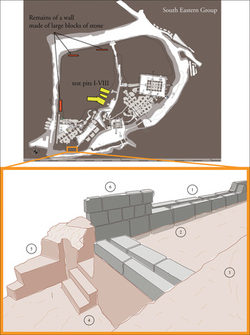
Previous investigations have recorded a short segment of dressed-stone wall running along the northern trench (itself cut during church construction) that borders the south-east group of churches at Lalibela (Angelini Reference Angelini1967; Taffesse Reference Taffesse1983). Our excavation indicates that the same wall running beneath the spoil heaps dates to between the early tenth and early eleventh centuries. Abundant pottery fragments and faunal remains were also recovered, attesting secular occupation (Bosc-Tiessé et al. Reference Bosc-Tiessé, Derat, Bruxelles, Fauvelle-Aymar, Gleize and Mensan2014: 156–57). Finally, other architectural features have provided evidence for a monumental wall that once surrounded the entire complex, as indicated by segments of the wall found in situ in various places at Lalibela (Figure 2: inset map).
Inset map: south-eastern group of rock-cut churches of Lalibela, showing the location of wall segments along the great north and west trenches, and on the roof of Gabre'el-Rufa'el church (outlined in orange). Structure on the roof of Gabre'el-Rufa'el: 1) double-sided, 1.10–1.15m-thick wall, consisting of a double row of ashlar blocks; 2) shallow wall trenches dug into the natural rock; 3) traces of walls anchored into the natural rock are also observed on the roof; 4) rock-cut stairs; 5) remains of partial, rock-cut walls with off-set vertical joints; 6) partial remains of a three-course wall of large dressed stones (illustration by A. Garric/Lalibela Mission).

Additionally, segments of a similar wall, preserved to a height of three courses, are recorded on the roof of the church of Gabre'el-Rufa'el (see also Phillipson Reference Phillipson2009: 146; Mercier & Lepage Reference Mercier and Lepage2012: 227). An entryway, sculpted stairs and the remains of rock-cut walls—evidence for a chamber hanging above the church's rear courtyard—were also recorded here (Figure 2). These testify to the existence of a wall system built two centuries before the transformation of the site by King Lalibela. The walls were partly destroyed in the thirteenth century by the cutting of the churches and trenches, with what remained covered by the resultant debris.
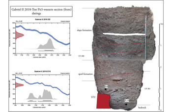
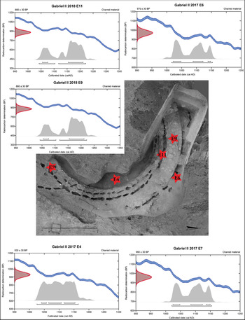
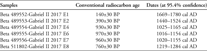
Excavation of the enormous southern spoil heap associated with the south-eastern church group has revealed a succession of occupation and abandonment phases from the eleventh–thirteenth centuries to the present. Starting from the top of the spoil heap, recent commingled human remains were found at a depth of 1.50m below the surface, thus confirming a pattern of reburial within spoil heaps that had previously been observed around the first group of churches, in the north-west of the site (Bosc-Tiessé et al. Reference Bosc-Tiessé, Derat, Bruxelles, Fauvelle-Aymar, Gleize and Mensan2014: 154). Beneath these burials, three occupation levels were recorded, the most recent of which—approximately 0.50m thick—was found 1.50m below the surface, and contained the remains of a collapsed stone house dated to between the late seventeenth and late eighteenth centuries. This building rested upon another 1.20m-thick, homogeneous occupation level dated to between the mid fifteenth and mid sixteenth centuries. The lowest stratigraphic level within the spoil heap was located between 3.20 and 4.70m below the surface, and contained several structures. The more recent of these were two poorly constructed alignments of basalt flagstones (ST4) associated with a fireplace, and dated to the thirteenth century (Figure 3). Next, some 0.45m below the flagstones, was a portion of wall (ST3) built of carefully squared, basaltic rubble. Then, below this, a third structure was found in direct contact with the natural substrate, and comprised both cut and built elements, including a carved, circular groove, 9m in diameter and 0.90m deep (ST1). Surrounding the carved groove was a 1m-wide wall built of mortar and basalt (ST2), and of the same diameter as ST1 (Figure 4). Finally, a rubble partition wall (ST5) adjoining ST2 and associated with a floor and a ceramic pot, the latter broken in situ, was revealed. This wall covered ST1 and was dated to between the early eleventh and the mid twelfth centuries (for the relevant radiocarbon dates, see Table 1).
Stratigraphic log and radiocarbon dates for ST4 in the south-east spoil heap at Lalibela. Dates calibrated by Beta Analytic using BetaCal 3.21 (Bronk Ramsey Reference Bronk Ramsey2009) and the IntCal13 calibration curve (Reimer et al. Reference Reimer2013) (figure by R. Mensan/Lalibela Mission).

Radiocarbon dates for ST1 and ST2 in the south-east spoil heap at Lalibela. Dates calibrated by Beta Analytic using BetaCal 3.21 (Bronk Ramsey Reference Bronk Ramsey2009) and the IntCal13 calibration curve (Reimer et al. Reference Reimer2013) (figure by R. Mensan/Lalibela Mission).

Radiocarbon dates obtained (dates calibrated by Beta Analytic using BetaCal 3.21 (Bronk Ramsey Reference Bronk Ramsey2009) and the IntCal13 calibration curve (Reimer et al. Reference Reimer2013))

Although the material associated with these structures, including the ceramics, is still undergoing study, it is already apparent that the wall surrounding the entire complex at Lalibela is stratigraphically associated with several construction stages that date to the mid tenth/mid twelfth centuries. Once certainly very impressive, these monumental built and carved structures belong to the earliest documented occupation phase at the site. These works were covered by debris of the thirteenth-century cutting of the churches. For now, we are unable to assess the function of either the earlier, circular carved and built structures, which could have served defensive, domestic, religious or funerary purposes, and the significance of the entire walled complex of which they were part. Whatever the case, the cutting of the churches in the thirteenth century represented both a complete departure in terms of the morphology of the site and a continuity in terms of the technology. The transformation of the site of Lalibela into a fully Christian religious complex represents an entirely new architectural programme that resulted in the burial of previous features under huge piles of debris, which physically effaced them from the landscape. There can be little doubt, however, that the technology involved in the cutting of these churches represented a continuation of local troglodytic practice and expertise. It is therefore not possible to perceive thirteenth-century changes at Lalibela strictly in terms of parallel religious and cultural shifts, but rather as the intersection of a transformative, Christian architectural programme (with probable elite ideological input) and a local culture whose ethnic, linguistic and religious affiliations remain obscure, but whose defining characteristic was troglodytism.
Documenting a wider troglodytic culture around Lalibela: Washa Mika'el
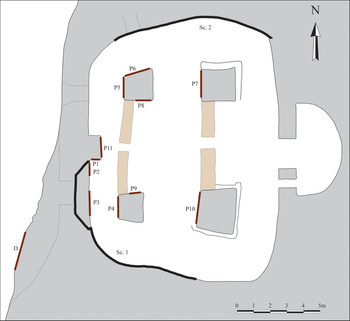
Lalibela is not unique in the local region. The cave of Washa Mika'el is cut into the interior of an ignimbrite massif (natural caves do not form in ignimbrite) located at an altitude of 3118m on the highland plateau, facing Lalibela to the north-west (Figure 1). Washa Mika'el's current façade exhibits carved and eroded sculptures belonging to an initial stage of cutting, as well as evidence for later natural and anthropogenic alterations (Figure 5). The eroded sculptures on the façade suggest that there were other rooms in front of it, which have now entirely collapsed. Sculpted friezes decorate the cave's northern, southern and eastern walls (Figure 6. 1–2), with the sculptures covering the full length of the northern and southern walls (just over 2m in height and 6m in length on the southern wall, and approximately 1.50m in height and 9m in length on the northern).
External western façade of Washa Mika'el cave church: entrance to the church and remains of animals sculpted on an earlier wall (photograph by R. Mensan/Lalibela Mission, 2017).

Layout of Washa Mika'el: Sc.) sculpted scenes; P) paintings; D) sculpted animal on the façade; dotted lines represent small galleries opening to doors and windows (figure by A. Garric/Lalibela Mission).

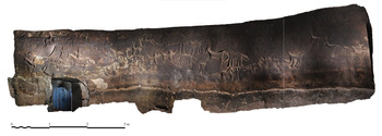
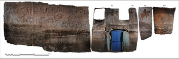
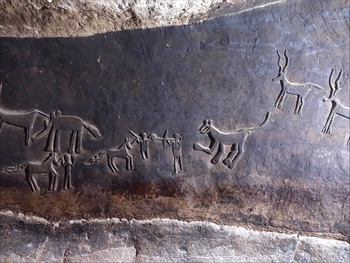
The northern wall is covered entirely in soot and one of the animal figures is damaged, while the sculptures on the southern wall are generally more eroded (Figures 7–8). The stone on the ceiling and the lower part of the walls is flaking, with large pieces having detached. Certain animal figures retain traces of paint (vertical bands) and engraved lines marking anatomical details or other patterns. The sculptures feature both adult and juvenile animals, particularly humpback cattle, birds, giraffes, elephants, camelids and some other possibly feline mythical creatures. Human figures, some clearly displaying male sexual attributes, stand blowing horns, brandishing staves or other weapons, or straddling mounts, while others stand on their mounts also brandishing staves, weapons and other objects. The figures follow one another in single file, fighting with or fleeing from each other. The northern wall features one to three registers, and the southern wall six (Figures 7–8). While such sculptures are commonly found in the rock art sites of Ethiopia and Eritrea (e.g. Brandt & Carder Reference Brandt and Carder1987; Calegari Reference Calegari1999; Le Quellec & Abegaz Reference Le Quellec and Abegaz2001; Le Quellec Reference Le Quellec2003; Hagos Reference Hagos2011; Insoll et al. Reference Insoll, Clack and Rege2015; Tsehaye Reference Tsehaye2019), the iconography and technique on display at Washa Mika'el are distinctive, as is the exceptional length of the carved surfaces. These sculptures date to a phase when Washa Mika'el had yet to be transformed into a church.
Northern wall of Washa Mika'el cave church (photogrammetry and orthophotography by A. Garric/Lalibela Mission 2017).

Southern and western walls of Washa Mika'el cave church (photogrammetry and orthophotography by A. Garric/Lalibela Mission 2017).

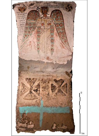
The site opens to the exterior via three small doors to the west and north-west, which are overlooked by three small windows (Figure 6). The interior layout is divided by three massive rock pillars and an approximately 2m-high rock wall that is surmounted by an arch, which demarcates the sanctuary. Other walls were built later in order to subdivide the central space. After the cave was converted into a church, paintings were added. These can be precisely dated to between 1270 and 1285, as their inscriptions mention contemporaries of King Yekuno Amlak (r. 1270–1285), the founder of the so-called Solomonic Dynasty that succeeded the Zagwe (see Insoll Reference Insoll2021). Five icon-like paintings feature saints (Saint George, Saint Cyriac/Qirqos and the Archangel Michael) and the Virgin and Child surrounded by archangels. Contemporaneous historical figures are also depicted, including the patron, Mahari Amlak (who first dedicated the church to Saint George before its name was changed to Mika'el), Her Amlak (the scribe), and governor [seyum] Newaya Krestos. These figures are accompanied by inscriptions asking the saints represented in the paintings to pray for both these men and for King Yekuno Amlak (Figure 6: P1–5; Figure 9) (Mercier Reference Mercier2002; Derat Reference Derat2018: 196–200).
Pillar facing the western entrance, with two sculpted crosses and a depiction of the archangel Michael (P4) from the time of King Yekuno Amlak (1270–1285), commissioned by Mahari Amlak. The inscription asks the saint to pray for the patron (photogrammetry and orthophotography by A. Garric/Lalibela Mission 2017).

The paintings were executed on white plaster and, when viewed in low-angled light, traces of application by hand can be observed. Although there was no plaster present beneath the painted remnants on the sculptures, and only a very thin layer under the painted sculptures in Lalibela's church of Beta Maryam, this plaster seems similar (subject to further investigation) to that used in the church of Gannata Maryam built under the patronage of King Yekuno Amlak. These paintings coincide with a second floruit of Christian power in the region, 50–70 years after King Lalibela's patronage of the site that now bears his name. They were already located in the western bay when later paintings—the majority stylistically dated to between the sixteenth and eighteenth centuries—were added throughout the church interior, demonstrating a new visual investment in the space (Figure 6.P6–10). At a later stage, and at different times, graffiti were carved or painted onto both the sculpted and painted scenes. This activity at Washa Mika'el indicates the transformation of the space from pre-Christian to Christian, mirroring the contemporaneous political and religious changes occurring in Ethiopia.
Discussion
The process of Christianisation and the transformation of troglodytic space is evident in paintings and sculptures of Lalibela and Washa Mika'el, and in their relationship with the transformation of the caves. The pre-Christian carved animal friezes on the northern and southern walls at Washa Mika'el are located at shoulder height, approximately 1.30m. The inside of the artificial cave was originally no more than 2m high. In a second phase, the ground was lowered, as indicated by the water-dissolution levels on the pillars, which formed at the original ground level. The lowering of the entire inner space of the cave may have been carried out in tandem with its transformation into a church. Alternatively, the cave could have been first transformed into a church, and the Christian paintings added on the upper register; the interior was then lowered, with the result being that all the paintings were now on the highest part of the walls. Either way, those transforming the cave chose not to erase the extant carved animal friezes.
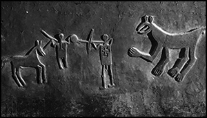
Further evidence of the efforts to Christianise the pre-Christian space are found on the walls of the lowered level, which bear crosses carved in low relief over the western interior door and on the two pillars facing the two western entrances (Figure 9). The date of these crosses is unknown, but they could only have been carved after lowering of the ground level had enabled the transformation of the cavity into a church. Other evidence of Christianisation is apparent through the carving of a cross onto the abdomen of one of the earlier, carved human figures on the northern wall (Figure 10). Taken together, this evidence indicates that the people who transformed the previous cavity into a church did not judge it necessary to remove the sculptures. Rather, they appropriated and lightly transformed them to fit the new religious function of the site, with the remarkable result that Washa Mika'el now displays a combination of Christian and non-Christian imagery. It cannot yet be established, however, whether the cavity was initially a secular or a religious place, such as a traditional religious shrine.
A cross carved on the extant figure's abdomen (see Figure 7)—a sign of Christianisation (photograph by C. Bosc-Tiessé/Lalibela Mission 2017).

Other types of data can be used to contextualise the sculptures at Washa Mika'el. From a technical point of view, the semi-flat, low-relief sculptures could be compared to those of Chabbe-Galma in the Rift Valley of south-eastern Ethiopia, which are dated to 6500–2500 BP (Le Quellec Reference Le Quellec2003: 63–64). At this unique site, however, the depth of the engravings gives the illusion of rounded relief (Le Quellec Reference Le Quellec2003: 64), which contrasts with the low-relief sculptures with two flat planes at Washa Mika'el. The depictions further vary with representation of the body in simplified profile at Chabbe-Galma, as opposed to the rendering of four limbs at Washa Mika'el, which gives the illusion of depth. The types of cattle depicted also differ, with humpless cattle (Bos primigenius f. taurus) at Chabbe-Galma and humpbacked oxen (Bos primigenius f. indicus) in Washa Mika'el. The introduction of humpbacked cattle, either directly from India or through the Arabian Peninsula, is believed to have occurred when the region began to experience increased aridity shortly after the last wet phase of the Holocene, most likely during the third to fourth centuries AD (Brandt & Carder Reference Brandt and Carder1987: 207; Le Quellec Reference Le Quellec2003: 65; Lesur-Gebremariam Reference Lesur-Gebremariam2009: 178). This implies that the sculptures at Washa Mika'el do not pre-date this period. Moreover, the scenes of a feline attacking other animals resemble rock paintings in northern Ethiopia and Eritrea, and are considered to be the most recent type of representations depicted at these sites (Calegari Reference Calegari1999: 19).
It appears that whoever carved the Washa Mika'el's sculptures used a similar method to that employed in Lalibela on the bas-relief above the western porch of the Beta Maryam church, which hypothetically dates from the thirteenth century. While intriguing, it is nevertheless premature to draw conclusions on dating based on this similarity alone. It is perhaps even more remarkable that the Washa Mika'el cave church and other early Christian sites of the Lalibela region display both sculptures and paintings, a combination of techniques that did not exist prior to the introduction of Christianity (painting being an exclusively Christian innovation in this context), and which disappeared in later periods. Representing more than the mixing of non-Christian and Christian elements, this technical syncretism constitutes an interesting fossile directeur of the moment of transition between two religious cultures.
While it is difficult to date the sculptures of Washa Mika'el, they nevertheless strongly evoke a troglodytic culture apparent elsewhere in the region. At Lalibela, the conversion of the rock-cut monument now known as Gabre'el-Rufa'el into a church was also characterised by profound transformations in the cutting phases. One of the pilasters in the monument's southern courtyard, for example, was truncated to enable the construction of windows opening to the east—an essential precondition for installing the sanctuary and the altar on which the Eucharistic liturgy is practised (Fritsch Reference Fritsch2008: 88). A clear clue to the timing of this architectural transformation is the altar: it was made for King Lalibela, dedicated to the Archangel Gabriel and is still kept in the church today (Bosc-Tiessé & Derat Reference Bosc-Tiessé and Derat2019: 112). Sculpted crosses on the eastern wall at the entrance to Gabre'el-Rufa'el mark the process of the monument's conversion into a church. While nothing can objectively establish that these alterations were contemporaneous, analysis of written evidence confirms the role of King Lalibela. There is therefore a strong probability that the transformation of the monument into a Christian chapel was initiated during his reign.
Conclusions
The cultural setting of the Lalibela region, starting from at least the eleventh to twelfth centuries AD, appears to have been troglodytic. As a rock-cutting technology, ‘troglodytism’ can be identified at Lalibela in the early architectural features revealed beneath the spoil heap associated with the south-eastern group of churches and in the initial church-cutting phases, as well as in the sculptures and the rock-cut transformations at Washa Mika'el. Troglodytism is thus an indicator of cultural continuity that was instrumental in the early introduction of Christianity and the Christianisation of previously non-Christian sites in the Lalibela region. As such, this continuity in sacred place is similar to the phenomena noted in other African contexts (e.g. Nicolas Reference Nicolas1966; Abungu Reference Abungu, Carmicheal, Hubert, Reeves and Schanche1994), and in India, for example (e.g. Chakrabarti Reference Chakrabarti and Insoll2001; Haaland & Haaland Reference Haaland, Haaland and Insoll2012).
The sites of Lalibela and Washa Mika'el are evidence of the diachronic persistence of troglodytism, and those who carved the rock-cut churches were the heirs of this culture. Both Lalibela and Washa Mika'el testify to the growing influence of Christianity and the transformation of troglodytic spaces in tandem with Christianisation. The pace at which the Ethiopian society at large became Christian remains to be determined, although excavations carried out in the cemetery of Qedemt, to the north-east of the churches of Lalibela, offer further clues (Gleize et al. Reference Gleize2015). This cemetery saw several phases of use between the eleventh and the eighteenth centuries. The oldest phase, between the eleventh and thirteenth centuries (phase A), is characterised by broad variability in the orientation of the graves, which suggests that such orientation was not a distinguishing feature in marking the religion of the deceased. While some graves (41.67 per cent) were oriented east–west in accordance with Christian rites, many others (58.33 per cent) were oriented differently and contained ceramics (Gleize et al. Reference Gleize2015: 239–42). In phase B (thirteenth to mid fifteenth centuries), 60 per cent of the graves were oriented east–west, with the remaining 40 per cent on different orientations. In phase C (mid fifteenth to eighteenth centuries), 94 per cent were oriented east–west, with only six per cent on a different orientation. This notable shift in favour of an east–west orientation suggests that this became a recognisably Christian indicator.
While numerous aspects, such as the function of the subterranean spaces or the date of the rock-cut caves before their transformation into churches, remain unclear, it now seems difficult to reflect on the rock-cut churches of Lalibela without taking into account the troglodytic aspects of the earlier society that occupied the central Ethiopian plateau in the eleventh and twelfth centuries. Continuity rather than change appears to have been key, with Christianity accommodating older ways of creating and transforming underground spaces. This certainly provides new elements for reinterpreting Ethiopian cosmopolitanism. While Christianity can be understood as the main agent in exposing Ethiopian societies to global influences, it can also be considered a unifying factor within a social environment whose cosmopolitan nature has long been overlooked. Indeed, although modern Ethiopia is particularly diverse in terms of religious faiths, material culture, languages spoken, and economic and political organisation, attention to troglodytism can only increase our understanding of past diversity in other social dimensions, such as territorial occupation and landscape exploitation.
Acknowledgements
This article is based on the results of multidisciplinary missions carried out since May 2009 at Lalibela and in its vicinity, under the guidance of the Ethiopian Authority for Research and Conservation of Cultural Heritage (ARCCH, Addis Ababa and Baher Dar); the Cultural and Tourism Office; the ecclesiastical authorities of Lalibela; and the French Center for Ethiopian Studies, based in Addis Ababa. The mission at Washa Mika'el was carried out in 2008 and 2017 with the approval of the ARCCH. Kidanemariam Woldegiorgis Ayalew, Emmanuel Fritsch, Nafisa Valieva and Laurence Meslin were part of our most recent field mission.
Funding statement
The fieldwork was funded by the Commission consultative des fouilles à l’étranger of the French Ministry of Foreign Affairs and the University of Paris I Panthéon-Sorbonne.