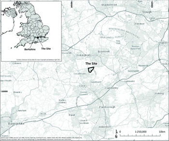


The term ‘burnt mounds’ refers to a group of largely later prehistoric archaeological features found across Britain and Ireland. These features consist of mounds of fire-cracked flint, fractured through heating and then rapid cooling on contact with water. The mounds are often associated with wells and rectangular troughs and are interpreted as having accumulated during the heating of water for a range of possible tasks. This paper presents new evidence on burnt mounds from the Bagshot Heath in southern England, deriving from a regionally significant site that was used and revisited at different points between the Early Bronze Age and Middle Iron Age. The site, at Bucklers Park, Crowthorne, Berkshire (NGR 484672, 165395) covered c. 102 ha and was excavated ahead of residential development by AOC Archaeology Group, who were commissioned by RPS on behalf of Legal & General Homes (Westall & Chittock Reference Westall and Chittock2019; Edwards Reference Edwards2020) (Fig. 1). This paper summarises the results of the excavations and specialist analyses, contextualising the results through the use of Bayesian modelling and placing them within wider research on later prehistoric burnt mounds, adding to discussions of these enigmatic features.
Site location. The area of the Bagshot Heath is visible directly to the east of the site

A SITE ON THE BAGSHOT HEATH, A REMOTE AREA IN LATER PREHISTORY
The site of Bucklers Park is in the Solent-Thames region (Hey & Hind Reference Hey and Hind2014) as well as the Middle Thames Valley (Lambrick et al. Reference Lambrick, Robinson and Dodd2009; Davies Reference Davies2017). The later prehistoric period in this area of southern England is generally thought of as being characterised by increasing sedentism and permanent settlement, with a transition from open to enclosed land occurring between 1600 and 800 bc (Lambrick Reference Lambrick2014, 124). The site is situated in an area known as the Bagshot Heath, which is a remote area today, straddling the borders of Berkshire, Hampshire, and Surrey (Fig. 1). Its soils are of sandy acidic composition and are consequently very poor for agricultural purposes. Such soils are typical of formerly fertile ‘forest brown earth’ in prehistory that was susceptible to exhaustion and erosion (Wessex Archaeology 1992; Oxford Archaeology 2011), meaning that their low agricultural potential has not always been the case. Examining archaeological evidence from the Bagshot Heath, however, shows that it was also a very sparsely populated area during later prehistory, making the site at Bucklers Park highly regionally significant.
Early Bronze Age evidence manifests across the region primarily in the form of round barrows. These funerary monuments are often associated with upland locations, but Bradley (Reference Bradley2014, 87–91) suggests that they were distributed more widely throughout the landscape, simply not surviving well in valley locations. The closest known barrows to the site are bowl barrows located at Woodenhill, Bracknell, c. 0.50 km north of the north-east corner of the site (SM1007929), and further afield to the north-east of the site at Bill Hill (SM1012921) and Swinley Park (SM1007944), Bracknell. Bell barrows are present on Bowledge Hill, Ascot (SM1013012) and Warren Lodge, near Finchampsted (SM1013244). By the Middle Bronze Age, permanent sedentary farming settlements are assumed to have emerged across the Solent-Thames region (Lambrick Reference Lambrick2014) and rectilinear field systems emerged and developed in lowland southern Britain during the Middle and Late Bronze Ages (Yates Reference Yates2007), although no sites of these dates have been identified in the immediate vicinity of the site. Similarly, an investigation by Davies (Reference Davies2017, 37–8; 119–20) of the Late Bronze Age and Early Iron Age in the Upper and Middle Thames region identifies no sites of this date in the Bagshot Heath area. Rather, activity seems to have been clustered along the waterways of the region, particularly in the Middle Thames Valley, with concentrations of sites along the Thames between Weybridge and Cookham and directly to the east in the area of Heathrow Airport (Davies Reference Davies2017, 37–8; 119–20; see also Lewis et al. Reference Lewis, Brown, Batt, Cooke, Barrett, Every, Mepham, Brown, Cramp, Lawson, Roe, Allen, Petts, McKinley, Carruthers, Challinor, Wiltshire, Robinson, Lewis and Bates2006; Reference Lewis, Leivers, Brown, Smith, Cramp, Mepham and Phillpotts2010).
The Early–Middle Iron Age witnessed the construction of hillforts across southern England. In the region around the site, hillforts are clustered along the Chiltern Hills and on the north Wessex Downs. A univallate hillfort known as Caesar’s Camp lies 1.20 km to the east of the site at Bucklers Park (SM1016334), representing an isolated geographical outlier, being the only recorded hillfort within a >10 km radius. It comprises a 10 ha area of spur, enclosed by a rampart up to 4.0 m in height (Lock & Ralston Reference Lock and Ralston2017), and it has been suggested that its location was related to the exploitation of iron deposits in tertiary geological outcrops nearby (Lambrick Reference Lambrick2014, 131). Test pits excavated to investigate geophysical anomalies at the hillfort identified features dating from the Late Neolithic/Early Bronze Age, Middle–Late Iron Age, and post-medieval periods, dated through lithics and pottery (Linford Reference Linford1995). A surface find of a coin of Cunobelin (Stukeley Reference Stukeley1724) also suggests early 1st century ad occupation.
The site at Bucklers Park adds important new evidence to understandings of later prehistoric East Berkshire. As summarised, Bronze and Iron Age evidence from the Bagshot Heath area consists of funerary monuments and a hillfort, but evidence for settlement and other types of land use have not previously been found. Bucklers Park provides evidence for long-lived activity over time, but questions of where settlements were located still remain, and they are revisited later in this paper.
The site itself was situated on a slope rising from c. 77.0 mOD in the far north-western corner to c. 100.0–105.0 mOD along its south-eastern edge, rising towards an area of higher ground directly to the south-east. Two streams, which were later culverted, probably relate to an aquifer and are shown on maps of the site pre-dating its development. These ran off the higher ground to the south-east, joining at a confluence towards the north-west of the site. The site overlaid Camberley Sand, Windlesham, and Bagshot formations that together form the Bracklesham Group, with superficial deposits of Quaternary River Terrace Gravels recorded in the north-western corner and in a small area in the centre of the site (British Geological Survey 2020). The underlying geology is described as clayey silt with gravel (Thames Valley Archaeological Service 2002), which was correlated with Bracklesham Beds (British Geological Survey 1981).
EXCAVATIONS AT BUCKLERS PARK, CROWTHORNE
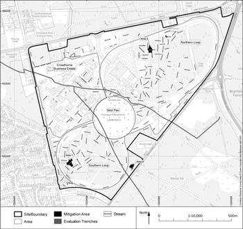
Three stages of archaeological evaluation took place at Bucklers Park during 2016–17 (site code CRW16). A total of 106 trenches were opened during Stages 1–3 (Fig. 2). Stages 1 and 2 did not uncover archaeology of enough significance to warrant mitigation. However, Stage 3 identified concentrations of burnt flint within three trenches and these areas were extended to expose these flint deposits and carry out three mitigation excavations (Areas 1–3) (Westall & Chittock Reference Westall and Chittock2019; see Edwards Reference Edwards2020 for two further phases of trial trenching). The natural deposit throughout all three areas (83.80–87.72 mOD) was dark grey sand (Roy Reference Roy2019) with frequent gravel in some places, overlain by clay, sand, and silty sand layers, varying across the site. The earliest cut feature dates to the Early Bronze Age (c. 1800 bc) and the establishment of a series of wells began in the early Middle Bronze Age, with one well located in each area of mitigation. Each well was associated with a disturbed mound of burnt flint, in addition to other cut features. The wells were revisited and recut over time until at least the beginning of the Middle Iron Age (c. 400 bc), when a possible roundhouse or ring-gully was also established at the site.
Plan of the site, showing the locations of the Stage 1–3 Evaluation Trenches, Mitigation Areas, and infrastructure relating to the former Transport Research Laboratory

Area 1
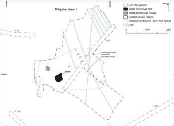
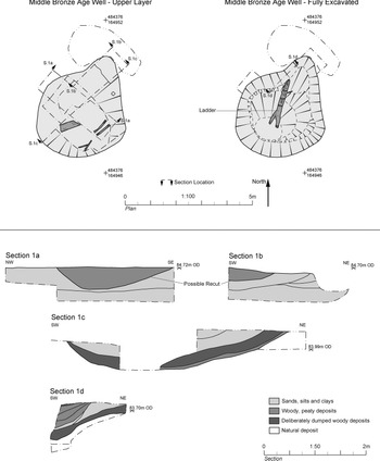
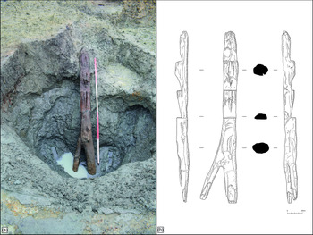
Area 1, located in the south-west corner of the site, consisted of a well, associated trough, and a burnt mound, all situated in the western part of the area (Fig. 3). The Middle Bronze Age well in Area 1 measured 4.0 × 5.0 m in diameter at its upper edge, narrowing to 1.30 × 1.0 m at its base, and was approximately 2.60 m in depth (Fig. 4). The sides of the well were, for the most part, almost vertical, but the northern edge formed a gradual slope. Leaning against the slope was a large, notched birch log ladder (Fig. 5), radiocarbon dated to 1263–1114 cal bc (95% probability; SUERC-80280). Ladders such as these, with simple notched steps down one face, are the most commonly known design used to access later prehistoric field wells and waterholes in England, many of which have been revealed in recent housing and infrastructure projects (ie Allen Reference Allen2010, 11–15). The species of wood used to make these ladders varied, with hazel and maple used at Briggs Farm, Priors Fen (Bamforth Reference Bamforth2011) and alder used at Fengate (Pryor Reference Pryor1978), both in Cambridgeshire, and Heathrow T5 (Allen Reference Allen2010, 11, 14). A poplar or willow ladder was found at the Early Iron Age ‘marsh fort’ of Sutton Common, south Yorkshire (Parker Pearson & Sydes Reference Parker Pearson and Sydes1997). However, oak was probably the species most commonly used. While all known non-oak ladders were fashioned from roundwood logs, both oak roundwood and cleft oak were used. Examples of later prehistoric ladders made from different forms of oak wood include a ladder of oak roundwood from Eight-Acre Field, Radley, Oxfordshire (Taylor Reference Taylor1995); radially-split oak examples from Bishops Cleeve, Gloucestershire (Bamforth Reference Bamforth2020), and Milton Keynes (Crank Reference Crank2013); a quartered oak example from Heathrow T5 (Allen Reference Allen2010, 12); and a cleft half-log of oak from Turing College, University of Kent, Canterbury (Goodburn Reference Goodburn2020). The forked base of the Bucklers Park ladder is unusual. Most of the examples mentioned above have bases sharpened to a point for insertion into the base of the well or waterhole. The ladder from Bishops Cleeve had a blunt base, but it had been set into a small stone-filled pit to ensure stability (Bamforth Reference Bamforth2020).
Plan of Area 1, showing the location of excavation areas and features

Area 1 well plans and sections

The log ladder in situ

In addition to the ladder, an assemblage of varied pieces of oak and birch may have formed revetments or supports within the Area 1 well or may have entered the well during episodes of deliberate dumping (see Appx S.4). Four stakes cleft from small oak roundwood with simply facetted tips and charring on and above the tips were present. Radially-split oak fragments and a birch splinter may represent woodworking offcuts from the working of larger timbers. A number of birch and oak planks and plank fragments were also present, with charring on two examples suggesting that they may have been recycled from other uses, such as within a building, perhaps one that burnt down. Similar planks were used as steps, held in place by stakes, at a well complex at Swalecliffe in Kent (Masefield et al. Reference Masefield, Branch, Couldrey, Goodburn and Tyres2003) and the planks and stakes from Bucklers Park may represent similar but dislodged steps. Dendrochronological analysis established a floating 76-year chronology for two of the oak stakes (see dating section below).
The Area 1 well was filled with a series of accumulations of sands, silts, and clays, and woody, peaty deposits, representing the silting up of the well and episodes of deliberate dumping. A possible recut of the well was also recorded, filled with a peaty deposit. Varying quantities of burnt flint and charcoal were present throughout the well’s stratigraphy, relating to the adjacent burnt mound. Two deposits containing large amounts of varied plant litter were interpreted as deliberate dumps, with the species present representing a damp woodland or meadow environment, including alder fruits, birch fruits, bracken, grass caryopses, and a raspberry seed. The two dumps differed in composition, with one containing larger wood fragments and the other containing a higher proportion of leaves. This may reflect seasonality, representing disposal events at different times of year (Robertson Reference Robertson2019). Insect remains identified from within the well were generally derived from natural habitats, but the head of a human flea was recovered from one of the dumped deposits along with other species suggestive of a ‘house fauna’ (see Appx S.1). It may be that the dumps of plant material within the well were waste derived from household environments. A small body sherd of Middle Bronze Age flint-tempered pottery was recovered (Doherty Reference Doherty2019) and birch charcoal was radiocarbon dated to 1607–1423 cal bc (95% probability; SUERC-77774), both deriving from peaty layers towards the centre of the well’s stratigraphy (Fig. 4: Sections 1c & 1d). The charcoal pre-dates the log ladder by several centuries and potentially represents redeposited material from outside the well or disturbed from earlier deposits during the recutting of the well.
Located c. 3.0 m to the north-west of the well was a sub-rectangular pit or trough with a relatively flat base, measuring 1.50 × 1.0 m in plan and c. 0.15 m deep (Fig. 3). The trough was filled with loose sandy silt and gravel containing burnt flint and charcoal, which produced a radiocarbon determination of 1495–1300 cal bc (95% probability; SUERC-88430). Approximately 8.0 m east of the trough was an undated circular feature measuring 0.40 m in diameter and 0.15 m deep, cut into the natural deposit and filled with topsoil.
Overlaying the fills of the well and trough was a spread of burnt flint, largely contained within a thin subsoil horizon, covering an area of c. 28.0 × 20.0 m, representing a burnt mound disturbed by modern forestry practices and probably by at least one phase of ploughing (Fig. 3). A less disturbed area of burnt flint and charcoal rich sandy clay silt is interpreted as representing the rough location of the original burnt mound. It was 0.26 m thick and extended over an area roughly 10.0 × 12.0 m to the north-west and north of the well. Charcoal from the burnt mound produced a radiocarbon determination of 1397–1215 cal bc (95% probability; SUERC-88431). This date, combined with the other dating evidence from Area 1, implies that this complex of features was perhaps in use over several centuries, with the log ladder representing the final phase of the well’s use.
Area 2
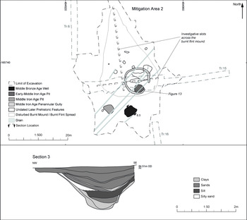
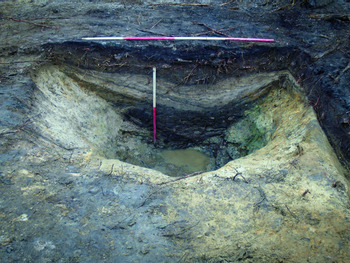
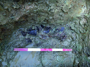
Area 2 was in the northern part of the site, consisting of a Middle Bronze Age well and associated disturbed burnt mound, a series of pits, and a Middle Iron Age penannular gully. The well measured approximately 4.0 m in diameter by 1.50 m in depth (Figs 6 & 7). A deposit of clay at the base contained 100 sherds of pottery belonging to a single vessel in a fairly coarse flint-tempered fabric (Fig. 8). A partial plain rim and a few sherds from the join of the base and lower wall, together with the fabric and thick-walled body profile, are strongly suggestive of the Middle Bronze Age Deverel-Rimbury urn tradition (Doherty Reference Doherty2019). It is likely that the deposition of this vessel was deliberate, though it may also represent the loss of a vessel used to draw water from the well, like the bucket found in a waterhole at Swalecliffe, Kent (Masefield et al. Reference Masefield, Branch, Couldrey, Goodburn and Tyres2003). Three body sherds of slightly finer Deverel-Rimbury wares of the Middle Bronze Age were also noted in the fill, along with two pieces of burnt flint.
Plan of Area 2, showing the location of excavation areas and features, with a section drawing of the Area 2 well

The Area 2 well section

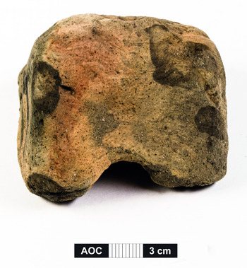
Fragmented ceramic vessel from the base of the Area 2 well in situ

Overlaying the well’s primary fill was a series of clays, sands, and silt. Micromorphological assessment suggested that they were generally formed through the natural silting of the well and the slumping of its sides. The source material for clay and silt layers included developed soils on land within or close to human settlement, as evidenced by anthropic inclusions within them. The sediment from one sand layer was interpreted as being derived from a bare surface or one that has been cleared of vegetation, perhaps to allow for occupation and cultivation (Roy Reference Roy2019). The age-depth model produced during the examination of the sediment sequence within the well suggests that the sequence of fills dates from the 11th century bc through to the medieval period, with the incorporation of earlier material into some fills (the secondary fill was the earliest fill sampled). Occasional pieces of burnt flint were found in the secondary fill, which also contained a single sherd of pottery in an iron-rich sandy fabric characteristic of the Early–Middle Iron Age assemblage on site, which may represent the carinated shoulder of a vessel (Doherty Reference Doherty2019). The silt layer within the well (Fig. 6: Section 3) contained a triangular loomweight fragment dating to the Middle Iron Age or later and a further sherd of pottery in iron-rich sandy fabric (Fig. 9). A radiocarbon date from a piece of oak charcoal from this fill produced a determination in the 14th–12th centuries cal bc (SUERC-77775), suggesting it was either redeposited from outside the well or from an earlier well fill.
Loomweight from the silt layer in the Area 2 well (see Fig. 6)

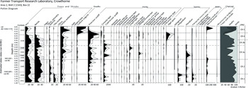
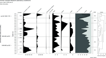
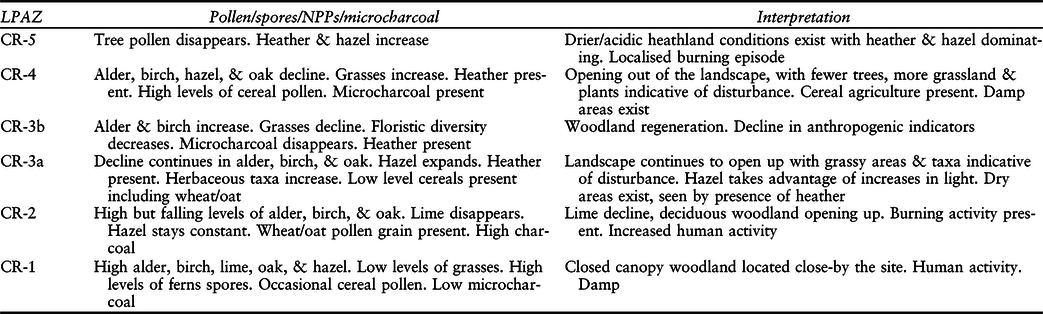
Insect remains from the fills of the Area 2 well were suggestive of a damp grassland environment in the immediate area with nearby oak trees. Scarabaeoid beetles indicated the presence of herbivore dung, possibly from livestock (see Appx S.1). Macroplant remains collected from the secondary fill and silt layer included a wide range of weed taxa, also indicating a damp environment: sedge, rush, greater plantain, grasses, and lesser chickweed (Robertson Reference Robertson2019). Examination of the pollen from the well indicates the landscape becoming increasingly open between the Bronze Age and the medieval period, but with periods of both increased human activity and woodland regeneration (Figs 10–11). Mixed woodland composed of alder, birch, lime, oak, and hazel dominated at the start of the sequence in the Middle Bronze Age, however even at this time there was evidence of disturbance in the landscape and limited evidence for cereal agriculture (Table 1). Human influence increased from around 1000 cal bc, seen through a rise in burning activity, limited evidence of agriculture, and the disappearance of small-leaved lime. Throughout the Iron Age the landscape continued to open up and evidence of cereal cultivation in the area was present. The late Roman/post-Roman period saw a temporary resurgence in tree pollen as secondary woodland took over before a dramatic decrease in tree pollen and an increase in cereal pollen in the medieval period. The wooded landscape did not recover after this time. Instead, the exploited (and likely degraded) soils allowed for the expansion of heather in the area.
Pollen percentage diagram from Bucklers Park, Area 2, Well 2, Sample 22. Percentages are shown on the x axis. LPAZ = Local Pollen Assemblage Zone (S. Richer)

Diagram showing summary pollen curves and other information from Bucklers Park, Area 2, Well 2, Sample 22. LPAZ = Local Pollen Assemblage Zone (S. Richer)

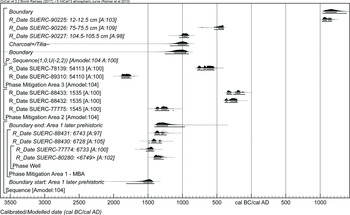
A chronological model for Middle Bronze Age activity from Area 1. Each distribution represents the relative probability that an event occurred at some particular time. For each of the radiocarbon measurements two distributions have been plotted, one in outline, which is the result of simple radiocarbon calibration, and a solid one, which is based on the chronological model use. The other distributions correspond to aspects of the model. For example, ‘start: Area 1 later prehistoric’ is the estimated date that this period of activity began in this area of the site, based on the radiocarbon dating results. The large square ‘brackets’ along with the OxCal keywords define the overall model exactly

SUMMARY OF THE MAIN CHANGES SEEN IN THE POLLEN DIAGRAM FROM BUCKLERS PARK, AREA 2, WELL 2, SAMPLE 22 AND VEGETATION HISTORY

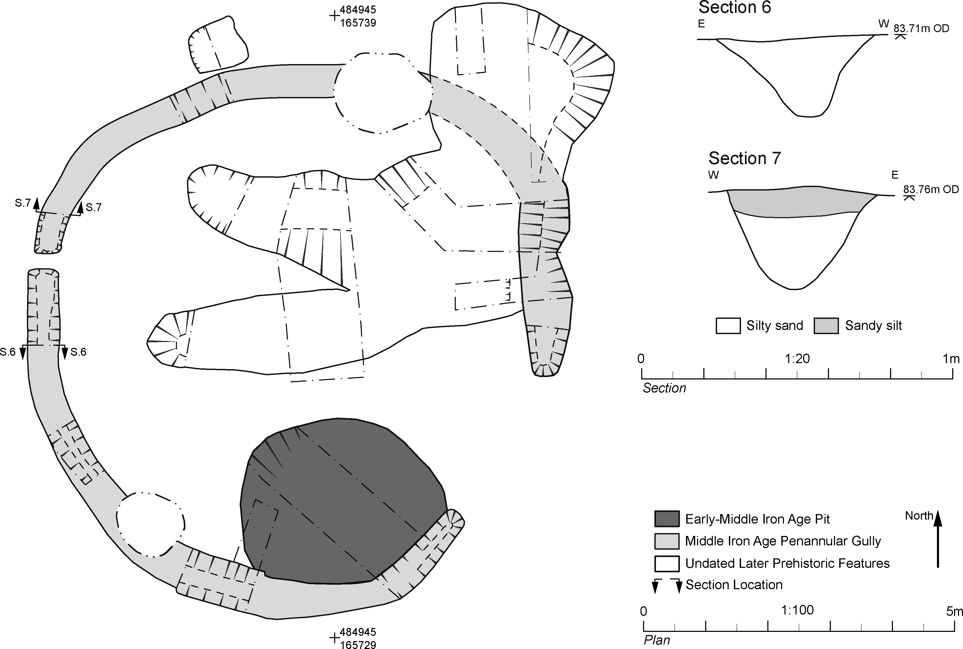
In addition to the Middle Bronze Age well recut during the Iron Age, there was also a distinct phase of Middle–Late Iron Age activity in Area 2, represented by other cut features. Approximately 3.75 m to the west of the well was a large sub-triangular pit of 4th–late 3rd century bc date (SUERC-88432 and -88433), approximately 3.0 × 4.0 m in plan and 0.62 m deep (Fig. 6). The primary fill of this pit was a layer of naturally accumulated sand. This was overlain by bands of silty sand, sandy clay, and a localised deposit of charcoal-rich silt containing degraded lumps of fired clay. Over these deposits lay the main fill, a friable dark grey sandy silt, with frequent inclusions of burnt flint. Above this were layers of charcoal rich sandy silt. The secondary fill contained a large fragment of triangular loomweight in a fine silty orange fabric with two partial, abraded perforations surviving (Raemen Reference Raemen2019). Given the burnt nature of the fills of the sub-triangular pit, it is possible that it represents a trough associated with a disturbed burnt mound (discussed below), although its form and late date are not consistent with the other more certain troughs on the site, and the burnt flint within it may represent redeposited material. Alternatively, it represents a working-pit, perhaps used in processes including burning. The two radiocarbon dates from the pit are statistically consistent and could be the same actual age. The later date provides the best estimate for the date of this feature in either 360–280 cal bc (37% probability; SUERC-88433: 1535) or 260–90 cal bc (58% probability). A possible post-hole was located to the immediate southwest of the pit. Its fills were similar to the upper fills of the pit, making it potentially contemporary, although no other dating evidence was recovered.
A large pit was located approximately 4.80 m north-east of the Area 2 well. Its primary fill comprised redeposited natural sand and contained seven undiagnostic sherds in iron-rich sandy fabric, fitting either an earliest Iron Age or Middle Iron Age date (Doherty Reference Doherty2019). The fills of this pit were truncated by a shallow penannular gully with an internal diameter of c. 8.0 m, which also cut the fills of several other features in Area 2 (Fig. 13), representing the drainage gully of a small Iron Age roundhouse. Although no evidence for walling was recovered, the break in the circuit to the south-east of the gully is interpreted as a doorway entrance. A smaller break in the north-west of the gully’s circuit is more unusual and may represent a secondary entrance. The penannular gully was c. 0.50 m wide by 0.25–0.30 m deep, with a U- to V-shaped profile and contained two fills: mid-grey-brown silty sand capped by mid-yellow-brown sandy silt. Dating evidence within the primary fill of the penannular gully included 47 sherds of iron-rich sandy pottery. The diagnostic sherds included sherds from two round-shouldered jar forms, one of which had finger-tipping on its rim. These characteristics suggest a transitional Early/Middle Iron Age date probably in the 5th–4th centuries bc (Doherty Reference Doherty2019). A fragment of fired clay, possibly representing a loomweight or daub, was also recovered from a gully fill (Raemen Reference Raemen2019).
Detailed plan and sections of the penannular gully in Area 2

The topsoil in Area 2 sealed a 0.10–0.15 m thick redeposited subsoil deposit containing charcoal and burnt flint. Although it overlaid the fills of the penannular gully and other cut features, this deposit is interpreted as deriving from an earlier burnt mound that has become spread over a much wider area through a combination of later ploughing and modern forestry activity (Fig. 6). It contained no dating evidence, but burnt flint from Middle Bronze Age deposits within the Area 2 well suggests that the burnt flint within the disturbed mound was also deposited during this period.
There were a number of features in Area 2 that contained no firm dating evidence and, because of the evident long history of use of this area during the Bronze and Iron Ages, may have dated to either period (see Fig. 6). These features contained burnt flint, suggesting they may relate to the same phase of prehistoric activity that resulted in the production of the burnt mound in this area. Alternatively, fire-cracked flint may have been deposited within it as a result of the burnt mound being spread by later activity. The undated features included two elongated oval pits and located within the circuit of the penannular gully. The eastern ends of these two pits were interpreted as having been cut by a later, roughly circular pit or well measuring 4.60 m and up to 1.62 m deep. The eastern and southern sides of the feature were fairly steep but the northern edge appeared to be more gradual, perhaps providing ramped access to the water source, as observed in excavations at Perry Oaks, Heathrow Airport (Lewis et al. Reference Lewis, Brown, Batt, Cooke, Barrett, Every, Mepham, Brown, Cramp, Lawson, Roe, Allen, Petts, McKinley, Carruthers, Challinor, Wiltshire, Robinson, Lewis and Bates2006).
Area 3
Area 3 produced a well containing Late Bronze Age–Early Iron Age evidence adjacent to a disturbed burnt mound and associated trough (Fig. 14). The well was approximately 2.60 m in diameter, narrowing to around 0.50 m in diameter at 2.25 m deep. The feature was not excavated to its base for health and safety reasons. However, as in Area 1, a lower level of geology was exposed in the form of a fine grey sand, suggesting it may almost have been bottomed.
Plan of Area 3, showing the location of excavation areas and features. Section drawings of the Area 3 well and trough

The deepest fill observed within the well (at 84.98 mOD, not illustrated in Fig. 14) was a pale mauve sand, overlain by a clayey silt containing two small, conjoining rim-sherds in a well-finished flint-tempered fabric. They formed part of the rim from a thin-walled fineware bowl, post-dating the Middle Bronze Age. The vessel may represent a bipartite bowl, more typical of the Late Bronze Age/Earliest Iron Age post-Deverel-Rimbury (c. 1150–600 bc), or a more strongly flaring type, associated with Early Iron Age traditions such as the Park Brow-Caesar’s Camp or Darmsden-Linton groups (c. 600–400/300 bc; Doherty Reference Doherty2019).
The remainder of the well was filled by a series of alternating sand, clay, and gravel deposits suggesting collapse or silting from the sides of the well, the lowest of which is the lowest represented fill in Figure 14, Section 10. Micromorphological assessment of this deposit suggested that the base of the well was filled either through mass movement or intermittent deposits that were reworked or mixed by repeated bioturbation. The material within the base of the well was influenced over time by vegetation and was rich in organic matter, which was the subject of bioturbation even in deeper parts of the horizon. Phytoliths were indicative of grass vegetation. Diatoms were also observed and indicate prevailing damp conditions within the base of the well (Roy Reference Roy2019).
The upper fills of the well comprised a deposit of charcoal-rich material, which produced an Early Iron Age determination of 790–540 cal bc (95% probability; SUERC-78139), and a deposit of peaty, sandy, clayey silt. The Early Iron Age date supports the dating of pottery from the base of the well to the earliest or Early Iron Age, although the charcoal rich fill may have been deposited significantly later than the earliest fills making a Late Bronze Age date for the pottery also possible.
A sub-rectangular trough lay approximately 2.0 m to the south-east of the Area 3 well (Fig. 14). It measured 1.90 m long by 0.85 m wide and approximately 0.29 m deep with a flat base. The fills of the trough were a slightly peaty sand and a sand layer with occasional lenses of clayey silt. A potential recut was filled by layers of clayey sand, sandy silt, and silty sand. All fills contained burnt flint with the highest concentrations in alternating fills, suggesting cyclical activity. Radiocarbon dating has provided a terminus post quem for the infilling of this feature in or after 1890–1740 cal bc (95% probability; SUERC-89310). This Early Bronze Age date means the burnt mound Area 3 is potentially considerably earlier than the waterhole, suggesting the main water source for the burnt mound may have been the nearby stream. Alternatively, the well may have been substantially recut.
The remains of the largely extant burnt mound in Area 3 covered a roughly rectangular area, 12.0 × c. 7.50 m, the core of which lay to the south of the well and the trough, although the trough was also covered by and partially infilled with a spread of disturbed mound material (Fig. 14). The core of the mound was 0.14–0.18 m thick, but it had been disturbed by modern managed forestry activity and a series of ridges and furrows.
DATING BUCKLERS PARK: DENDROCHRONOLOGY, RADIOCARBON DATING, AND BAYESIAN MODELLING
In order to establish a firm chronological sequence of site use at Bucklers Park, a multidisciplinary approach was used, including dendrochronology, radiocarbon dating, and Bayesian modelling. Four pieces of oak (two stakes, an offcut, and a plank), were considered suitable for dendrochronological analysis (Table 2, see also Appx S.4). None retained their outermost rings, either because they had been trimmed off or had decayed. Although the two stakes were small they were slow-grown, with a similar growth-rate to the offcut. In contrast the plank was relatively fast-grown.
OAK SAMPLES USED FOR DENDROCHRONOLOGICAL ANALYSIS

The four sequences were compared against each other. This produced only one acceptable correlation, between the stakes (t=4.33) and a sub-chronology, 35_36mn, 76 years long was constructed. The sequence 35_36mn was compared with all available prehistoric chronologies in England, but this did not produce any significant correlations and so it remains undated. This is probably because 35_36mn is a short, poorly replicated sequence (ie with only two components) and dendrochronological coverage in the Bronze Age is patchy (Cathy Tyers pers. comm.).
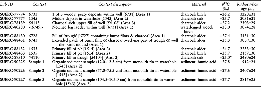
Twelve samples were submitted for radiocarbon dating, results of which are presented in Table 3 as conventional radiocarbon ages (Stuiver & Polach Reference Stuiver and Polach1977). In the modelling, they have been calibrated using the internationally agreed terrestrial calibration curve (IntCal13; Reimer et al. Reference Reimer, Bard, Bayliss, Beck, Blackwell, Bronk Ramsey, Buck, Cheng, Edwards, Friedrich, Grootes, Guilderson, Haflidason, Hajdas, Hatté, Heaton, Hoffmann, Hogg, Hughen, Kaiser, Kromer, Manning, Niu, Reimer, Richards, Scott, Southon, Staff, Turney and van der Plicht2013) and OxCal v. 4.3 (Bronk Ramsey Reference Bronk Ramsey2009). Simple calibrated results are presented in plain text and rounded outward to 10 years. The italicised dates presented in the text below are posterior density estimates derived from mathematical modelling of archaeological problems and have been rounded outward to 5 years. These dates can change with the addition of new data or when the modeling choices are varied.
SAMPLES AND RESULTS OF THE RADIOCARBON DATING PROGRAMME FROM BUCKLERS PARK

δ13C value marked with an asterisk (*) denotes an assumed value
A Bayesian approach has been applied to the interpretation of the chronology of some of the Middle Bronze Age activity at Bucklers Park (Buck et al. Reference Buck, Cavanagh and Litton1996). For further methodological information, see Appendix S.3.
Samples and models
The excavation and radiocarbon dating at Bucklers Park can be defined as four discrete areas for consideration: Areas 1, 2, and 3, and the pollen sequence. The radiocarbon dating is presented below spatially related to these areas, and with the later prehistoric dates in Area 1 and the pollen sequence subsequently modelled within OxCal v. 4.3.
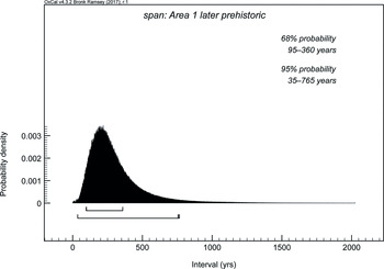
Area 1. There are four radiocarbon dates available from features in Area 1. The samples were associated with the well (SUERC-77774 & -80280), the burnt mound (SUERC-88430), and the trough (SUERC-88431). The two samples from the well were initially considered to have a stratigraphic relationship. SUERC-80280 is from the birch ladder, while SUERC-77774 is from a fragment of charcoal from a fill towards the centre of the stratigraphic sequence. The fill is actually earlier than the ladder and suggests the charcoal and associated sediment were redeposited from earlier activity on site or from earlier use of the well itself. As such, no stratigraphic relationship is modelled. However, the four dates can be modelled together, following the simple Bounded Phase model described in Hamilton and Kenney (Reference Hamilton and Kenney2015), to provide a robust date for the associated later prehistoric activity in Area 1. The model has good agreement (Amodel=104) and estimates the activity here started in 1815–1410 cal bc (95% probability; Fig. 12; start: Area 1 later prehistoric), and probably in 1565–1435 cal bc (68% probability). The activity ended in 1405–970 cal bc (95% probability; Fig. 12; end: Area 1 later prehistoric), and probably in 1375–1215 cal bc (68% probability). The overall temporal span of this dated activity was 35–765 years (95% probability; Fig. 15; span: Area 1 later prehistoric), and probably 95–360 years (68% probability).
The span of dated activity in Area 1 as derived from the chronological model shown in Fig. 12

Age-depth model for the pollen sequence in the Area 2 well

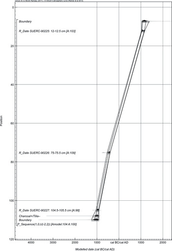
Area 2. Six radiocarbon dates come from features in Area 2. Three of these are on single fragments of charcoal from a fill towards the centre of the stratigraphic sequence (SUERC-77775) and the primary fill of the sub-triangular pit (SUERC-88432 and -88433). Additionally, there are three measurements (SUERC-90225–7) on the humic fractions of highly organic sediment samples from within the well. The aim of these samples was to provide a chronology for the pollen analysis through the feature. The two results from the pit are statistically consistent (T’=3.2; ν=;1 T’(5%)=3.8) and could be the same actual age. The later date (SUERC-88433) provides the best estimate for the date of this feature in either 360–280 cal bc (37% probability; Fig. 16; SUERC-88433: 1535) or 260–90 cal bc (58% probability). The charcoal sample from the well produced a Bronze Age result (Fig. 16; SUERC-77775: 1545) in the 14th–12th centuries cal bc, whereas the sediment sequence within which it was recovered dates from the 11th century cal bc to the medieval period. The charcoal corresponds to a depth of ∼94 cm in the pollen sequence, which would equate to the Early Iron Age. Given the nature of the deposit and the likelihood that residual fragments of charcoal could be incorporated into the fills, this result is excluded directly from the age-depth model that was created for the sequence of dates on organic sediment.
The age-depth model follows the approach laid out in Bronk Ramsey (Reference Bronk Ramsey2008), and most of the samples derived from the sediment at the depth of particular interest. The lowest result (SUERC-90227) came from a depth of ∼105 cm, yet a rise in charcoal and rapid decrease in Tilia were noted at 108 cm, so the age-depth model provides an estimate for when that ‘event’ occurred. At 108 cm depth there is a rise in charcoal and the disappearance of Tilia, suggesting the landscape was being opened up at this time. The modelling estimates this occurred in 1180–905 cal bc (95% probability; Fig. 16; Charcoal+/Tilia–), and probably in 1065–940 cal bc (68% probability). There are further indicators of increasing human activity from about 75 cm depth. From here all the tree species, with the exception of hazel, decrease dramatically while there is a rise in Plantago. This period of deforestation and disturbance begins in 540–400 cal bc (95% probability; Fig. 16; SUERC-90226: 75-75.5 cm), and probably 480–405 cal bc (68% probability). The waterhole continued infilling throughout the Iron Age and Roman periods with the sample from near the top of the sequence at 12 cm indicating that for all intents and purposes it was completely infilled by cal ad 1030–1170 (95% probability; Fig. 16; SUERC-90225: 12–12.5 cm), and probably either cal ad 1040–1095 (52% probability) or cal ad 1120–1160 (16% probability).
Area 3. There are two radiocarbon dates from Area 3. The first (SUERC-78139) is on a fragment of alder charcoal recovered from the charcoal-rich upper fill of the well. This result calibrates to 790–540 cal bc (95% probability; Fig. 12; SUERC-78139: 54113). The second (SUERC-89310) is on a fragment of oak charcoal that was recovered from the primary fill of the trough. The single measurement on oak charcoal, which has not been clearly identified as roundwood or blocky heartwood, provides an Early Bronze Age terminus post quem for the infilling of this feature in or after 1890–1740 cal bc (95% probability; Fig. 12; SUERC-89310: 54110).
DISCUSSION: TEMPORAL SCALES AT BUCKLERS PARK
The site at Bucklers Park has provided a detailed record of Bronze and Iron Age activity centring on the drawing and heating of water. The earliest feature on site was the trough in Area 3, which dated to the end of the Early Bronze Age and contained burnt material relating to the adjacent burnt mound, thought to have formed through the heating of water from the nearby stream. Wells were dug in Area 1 and 2 during the Middle Bronze Age, when heating of water from these features also produced burnt mounds in these areas. The 12th–13th century bc ladder in the Area 1 well marks its final phase, but the Area 2 well remained functional, continuing to silt up into the medieval period. A third well was established in Area 3 during the Late Bronze or Early Iron Age and during the Middle Iron Age a single roundhouse was established at the site, which evidently retained its significance long after the use of hot stone technology ceased to be its focus.
The wells at Bucklers Park fit into a much wider group of later prehistoric wells in southern Britain and beyond, features of key importance for obtaining water. The log ladder and potential revetments relate to accessing the water within the Area 1 well during the Middle Bronze Age but finds from within the wells indicate other potential uses that go beyond the collection of water. Deposits of plant matter, possibly deriving from household contexts, were dumped within the Area 1 well, suggesting it may have been used as a place for the disposal of rubbish towards the end of its life. Later in the Bronze Age, a near complete ceramic vessel was deposited at the base of the Area 2 well, possibly representing the loss of this vessel within the well, but more likely a deliberate deposition: a special or ‘odd’ deposit (see Garrow Reference Garrow2012), fitting into a strong tradition of ‘structured deposition’ in rivers and other watery places in the wider Upper Thames region (eg, Sidell et al. Reference Sidell, Cotton, Rayner and Wheeler2002, 30–2; Poulton Reference Poulton, Hayman, Jones and Poulton2012, 22–6). The waterholes investigated at Perry Oaks, Heathrow (Lewis et al. Reference Lewis, Brown, Batt, Cooke, Barrett, Every, Mepham, Brown, Cramp, Lawson, Roe, Allen, Petts, McKinley, Carruthers, Challinor, Wiltshire, Robinson, Lewis and Bates2006, 142–5) also contained objects such as adze and axe hafts, wooden beaters, and polished stone axes deposited in their lower fills. Further afield, at Swalecliffe in Kent, a near complete pottery bucket associated with a withy sling was found at the base of a Late Bronze Age waterhole and an adjacent Late Bronze Age waterhole contained an oak yoke for human use (Masefield et al. Reference Masefield, Branch, Couldrey, Goodburn and Tyres2003). These objects were interpreted as equipment used for the collection and transportation of water from the well for use nearby. The pottery bucket at Swalecliffe had been placed upside down at the base of the waterhole, an act of inversion interpreted as an offering, perhaps made in a time of drought. With these examples in mind, the ceramic vessel deposited in the Area 1 well at Bucklers Park may be a similar type of deposition. Although this vessel was incomplete and highly fragmented, deposition of complete or partially complete pottery vessels in rivers or channels is known in the region (Lambrick et al. Reference Lambrick, Robinson and Dodd2009, 288–9) and, at Heathrow, it was noted that waterholes appeared to be a particular focus for the deposition of large parts of Middle Bronze Age vessels (Leivers et al. Reference Leivers, Every and Mepham2010).
The wooden planks found within the Area 2 well are interpreted as revetments, although they may also have been dumped within the well along with household plant material. The charred plank perhaps represents a re-used structural component. The re-use of charred planks from presumably above ground structures is also documented at Swalecliffe, Kent, where one of 17 wells and waterholes contained a 2.0 m long charred oak plank supported by two stakes used as a step set into the side of a large Late Bronze Age waterhole (Masefield et al. Reference Masefield, Branch, Couldrey, Goodburn and Tyres2003, 74–5).
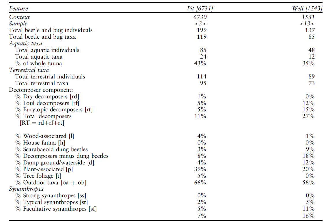
Detailed analysis of insect remains from the Area 1 and 2 wells and pollen remains from the Area 2 well at Bucklers Park have provided insights into the formation of the site over time (see Appendices S.1 & S.2). An abundance of aquatic beetles in all the samples analysed was indicative of the presence of standing water in the wells for at least some of the time during the periods that the deposits accumulated (Table 4). Preservation was less good in the uppermost of the two samples from the Area 2 well, which might perhaps reflect less complete waterlogging caused by periodic reductions in water level. Fluctuating ground water levels around burnt mound sites has also been found at Meriden in the West Midlands (Richer Reference Richer2020), however the pollen evidence suggests a general drying out of the landscape during the life of the Area 2 well, indicated by the increasing presence of heather in the area. Insect remains from the site have also provided information about the changing environments present in the local area, as remains of terrestrial insects recovered from small water bodies generally reflect the ecological conditions in their near vicinity. While some insect remains in both wells almost certainly represent local habitats and vegetation, there was good evidence from macroplant remains in the Area 1 well that two distinct episodes involving the deliberate dumping of woody plant matter into the feature (Robertson Reference Robertson2019). Insects associated with the foliage of trees and shrubs, and with wood and bark, in sample <3> from the Area 1 well could have arrived with this material, although it seems likely that trees and shrubs were also present close by. The local presence of trees and shrubs is supported by the pollen evidence, with high percentages of alder, birch, oak, and hazel existing in the area until the start of the Iron Age.
MAIN STATISTICS FOR INSECT ASSEMBLAGES WITH >100 INDIVIDUALS

Ecological codes shown in square brackets are: d – damp ground/waterside; h – house/building; l – wood/timber; oa – outdoor taxa not usually found within buildings or in accumulations of decomposing matter; ob – probable outdoor taxa; p – plant-associated; sf – facultative synanthropes; ss – strong synanthropes; st – typical synanthropes; t – tree-associated; u – uncoded; w – aquatic. A full species list can be found in Table S.1
Ground conditions close to the wells in Area 1 and 2 were probably somewhat damper than the surrounding land. There were indications that rushes (Juncus) and semi-aquatic grasses such as reed sweet-grass (Glyceria maxima) grew close to the Area 1 well. Sedges (Cyperaceae) were present close to the Area 2 well, and insects generally associated with damp ground were commonest in this feature. Pits and wells often function as pitfall traps for ground beetles (Carabidae) and the range of species identified reflects damp conditions around the Area 2 well, as well as dryer open ground in the vicinity of both wells. There were hints of disturbed ground in the assemblages from the Area 1 well, and various species in both features were particularly suggestive of grassland. Grasses are represented in the pollen throughout the life of the Area 2 well with periods of disturbance seen through the presence of plantain (Plantago lanceolata-type) in the Early Bronze Age and the later Iron Age.
Scarabaeoid dung beetles from the Area 1 and 2 wells accounted for 3% and 9% of the terrestrial insect fauna, respectively, indicating low-level or ‘naturalistic’ grazing activity in the vicinity of the Area 1 well, and grazing herbivores close to Area 2 well or more intensive use of nearby land for grazing by the time the well was in use (Smith et al. Reference Smith, Whitehouse, Bunting and Chapman2010; Reference Smith, Nayyar, Schreve, Thomas and Whitehouse2014). The scarabaeoid beetles represented are all primarily associated with herbivore dung but some of the species represented will also exploit other foul matter (Jessop Reference Jessop1986, 19–25), so it is conceivable that the higher proportion in the Area 2 well might relate to the proximity of settlement as well as to the presence of livestock in the local environment. A notably low presence of dung fungal spores in the pollen assemblage may be due to the disturbance of the dung by scarabaeoid beetles preventing the growth of the spores, or a low moisture content within the dung (Perrotti & van Asperen Reference Perrotti and van Asperen2019). Alternatively, growth is inhibited if conditions are too wet, which is highly likely given the presence of aquatic beetles in the well.
There were hints, particularly in the Area 1 well, that some of the litter dumped within it was associated with buildings, indicated by a human flea (Pulex irritans) and a few beetles suggestive of a ‘house fauna’. A riffle beetle (Elmis aenea), found exclusively in clear running water, may suggest the disposal of waste water, as the species would not naturally occur in a still water body. A bread beetle (Stegobium paniceum), a strongly synanthropic species primarily associated with cereal products, was recorded from the uppermost sample from the Area 2 well together with a range of decomposer taxa suggestive of occupation. The presence of cereal pollen throughout the samples from this well potentially attests to cereal cultivation in the local area. However, the reed sweet-grass (Glyceria maxima) produces a pollen grain that is often indistinguishable from cultivated cereals and, given that it was found in the archaeobotanical samples, it cannot be ruled out that the early cerealia-type pollen is actually this species. Despite some indications of probable small-scale occupation and cereal production in the site’s vicinity, the widespread trenching undertaken at the site did not result in the identification of Bronze Age field systems (Yates Reference Yates2007). The absence of direct evidence for Bronze Age roundhouses, enclosures, and of evidence for co-axial or aggregate field-systems, accompanied with the environmental evidence for pastoral farming, strongly suggests a sparsely occupied landscape including tracts of unbounded open grasslands suitable for the grazing of wide-roaming livestock.
Radiocarbon dating has suggested that the formation of burnt mounds at Bucklers Park may have commenced several centuries before the wells were first established, perhaps initially being formed using water from the nearby streams. The burnt flint throughout the fills of the wells suggests that the mounds continued to form following the establishment of the wells, or that this material was redeposited. Burnt mounds are common throughout the north and west of Britain and in Ireland (Buckley Reference Buckley1990; Ó’Néill Reference Ó’Néill2009; Hawkes Reference Hawkes2018) and are becoming increasingly recognised in the Midlands (Beamish & Ripper Reference Beamish and Ripper2000) and the south of England (Ford Reference Ford2007, 2–3; Simmonds et al. Reference Simmonds, Cook, Biddulph and Score2009), with two examples of burnt mound troughs recently excavated at Kilsby in Northamptonshire (Hart & Mudd Reference Hart and Mudd2015, 250). A small number of burnt mounds have been recorded within Berkshire. At Jennett’s Park, Bracknell, for example, three mounds were radiocarbon dated to between 1630 and 1260 cal bc (Simmonds et al. Reference Simmonds, Cook, Biddulph and Score2009). The closest known burnt mound site to Bucklers Park is at Barkham Square, Wokingham (Torrance & Ford Reference Torrance, Ford and Preston2003, 88–97), c. 6.0 km to the north-west, where the mound was dated by two determinations of 1400–800 and 810–410 cal. bc (Ford & Torrance Reference Torrance, Ford and Preston2003, 93). Many more exist across southern England including within the New Forest, East and West Sussex, and Kent. Instances of burnt mounds with waterholes have also been recognised at Perry Oaks, Heathrow (Lewis et al. Reference Lewis, Brown, Batt, Cooke, Barrett, Every, Mepham, Brown, Cramp, Lawson, Roe, Allen, Petts, McKinley, Carruthers, Challinor, Wiltshire, Robinson, Lewis and Bates2006, 145) and Bradley Fen, Cambridgeshire (Parker Pearson Reference Parker Pearson2005).
The accumulation of burnt stone on these mounds is thought to result from the heating of water using hot stones for one or more of a variety of proposed activities. The pits or troughs often associated with burnt mounds are generally thought of as being used to contain and heat the water. The troughs in Areas 1 and 2 at Bucklers Park fall into Ó’Néill’s Type 1, unlined rectangular pits, whereas other types are less rectangular and/or are lined with wood, wicker, or stone, for example (Ó’Néill Reference Ó’Néill2009, 80). The duration of burnt mound use is also a matter of debate. A study of a large Early–Middle Bronze Age burnt mound at Hoppenwood Bank, Northumberland utilised an integrated microarchaeological methodology and silicic microfossil analyses (Gardner Reference Gardner2019). It was concluded that hiatuses in the deposition sequence could represent periodic or seasonal use whilst deposition may have spanned as much as 500–700 years. The burnt mound deposits at Bucklers Park were too disturbed to attempt such analyses, with very limited evidence for stratigraphic episodes of deposition visible within the Area 3 mound. However, the Bayesian modelling of radiocarbon date ranges for each of the three burnt mound sites may support long use-periods. These might correlate with agricultural or pastoral cycles, such as transhumance, which may have brought itinerant herders to the area on a seasonal basis and at which times craft and industry tasks were also undertaken.
Existing interpretations of the processes involved in creating burnt mounds include food processing or cooking, brewing, bathing, the creation of steam for sweat lodges or saunas, textile production, the working of wood and leather, and even copper production (Barfield & Hodder Reference Barfield and Hodder1987; Thelin Reference Thelin2007; Ó’Néill Reference Ó’Néill2009 17–19; Hart & Mudd Reference Hart and Mudd2015, 250; Hawkes Reference Hawkes2018). Thelin (Reference Thelin2007) has provided a particularly useful overview of the history of burnt mound research and their possible functions. Brown and colleagues (Reference Brown, David, Hatton, O’Brian, Reilly, Taylor, Dennehy, O’Donnell, Bermingham, Mighall, Timpany, Tetlow, Wheeler and Wynne2016, 3) and Ó’Néill (Reference Ó’Néill2009, 188) have also considered the archaeological remains that might be expected of the varied interpretations of burnt mounds. A general absence of animal bone debris from burnt mound sites in Britain perhaps discounts hypotheses relating to cooking and certainly episodes of feasting, although Hawkes (Reference Hawkes2018, 166–70) favours this interpretation based on evidence from Ireland. No animal bone was found at Bucklers Park, even within the adjacent wells where organic preservation was good. The sweat lodge hypothesis is based on ethnographic studies (Barfield & Hodder Reference Barfield and Hodder1987) but, though use of lightweight tents is possible, lodge-like structures have not been certainly identified at burnt mound sites, with structural remains of any kind found at only around 5% of them (Ó’Néill Reference Ó’Néill2009). Bathing functions might be supported by three human fleas found within a waterlogged Early Middle Bronze Age pit associated with a number of burnt mounds, excavated as part of fieldwork relating to the Bexhill to Hastings Road Link in East Sussex (Champness et al. Reference Champness, Donnelly, Davies and Boothroyd2019, 81). The recovery of a single human flea head from Bucklers Park may also support this hypothesis, although it is thought most likely to have entered the Area 1 well along with plant matter deriving from a household context. Use of hot stones for bathing in relatively small pits would also appear a risky endeavour!
Although evidence for the production of Bronze Age fabrics and clothing is uncommon archaeologically, some archaeologists have suggested a possible function of burnt mounds sites in fabric and/or leather production (see Hawkes Reference Hawkes2018, 177–8). The presence of very fine textile production in the Bronze Age, using plant (‘bast’) fibres, which include flax, to produce linen has been spectacularly demonstrated at the domestic roundhouse riverine settlement at Must Farm, near Peterborough, Cambridgeshire, dating to c. 850 bc (with fine preservation due to a combination of charring and waterlogging; Harris Reference Harris2019a; Reference Harris2019b; Reference Harris2019c). More generally linen is known to have been in production from the Early Bronze Age beyond the British Isles and is inferred in Britain by the presence of flax as a crop. A Middle Bronze Age activity area at Nortoft Lane, Kilsby, in Northamptonshire included cremations and paired waterholes associated with burnt flint filled troughs, but no direct evidence of associated settlement (Hart & Mudd Reference Hart and Mudd2015; Mudd & Masefield Reference Mudd and Masefield2015, 250). A small pit nearby was interpreted as having been cut to contain an offering, comprising a complete cylindrical loom weight and a high concentration of flax seeds. It was suggested that the offering may have been made by, or for the memory of, an individual involved with the production of linen. Burnt mounds at this specific site were interpreted as potentially being related to flax processing, the ability to produce finer linen potentially being enhanced through the exposure of the fibrous material to heated water (Hart & Mudd Reference Hart and Mudd2015; Mudd & Masefield Reference Mudd and Masefield2015, 250).
Linen production requires a series of primary processes, including retting, which involves the decomposition of the pectin binding together the plant fibres using microorganisms and can take the form of dew/field retting, water retting, or snow retting (Ejstrud et al. Reference Ejstrud, Andresen, Appel, Gjerlevsen and Thomsen2011, 9). Water retting involves the submersion of the flax ‘beets’ in lakes, ponds, excavated pits, or running water (Andresen & Karg Reference Andresen and Karg2011), and the decomposition process produces an acidic, unpleasant odour, meaning that retting is often undertaken away from settlements (Townley Reference Townley2019, although see Andresen & Karg Reference Andresen and Karg2011). Heating the water accelerates the retting process (Ejstrud et al. Reference Ejstrud, Andresen, Appel, Gjerlevsen and Thomsen2011, 47). For example, with water temperatures of 17–20°C, water retting can take 5–10 days, whereas field or dew retting takes 2–5 weeks (Andresen & Karg Reference Andresen and Karg2011). Whilst use of heated water may also have been useful in leather production (J. Sidell pers. comm. with R. Masefield) the advantage of retting in troughs of warm water should also be considered in the context of interpreting burnt mounds, although it must be noted that no flax seeds were recovered from the site at Bucklers Park, as at Nortoft Lane, Kilsby. The troughs at Bucklers Park perhaps performed the same functions as the lined retting pits at locations with high water tables known in prehistoric Danish archaeology (Andresen & Karg Reference Andresen and Karg2011). The optimum temperature for retting could have been maintained by continuously adding controlled quantities of heated stone to a water-filled pit over a few days. Brown and colleagues (Brown et al. Reference Brown, David, Hatton, O’Brian, Reilly, Taylor, Dennehy, O’Donnell, Bermingham, Mighall, Timpany, Tetlow, Wheeler and Wynne2016, 259), in relation to an interpretation of Irish burnt mounds (fulachtaí fiadh), include dying in their favoured association with textile production, stating that: ‘… the most likely function for these sites is textile production involving both cleaning and/or dyeing of wool and/or natural plant fibres and as a functionally related activity to hide cleaning and tanning. Whilst further research is clearly needed to confirm if fulachtaí fiadh are part of the ‘textile revolution’ we should also recognise their important role in the rapid deforestation of the wetter parts of primary woodland and the expansion of agriculture into marginal areas during the Irish and British Bronze Ages’. Unfortunately, though unsurprisingly, the Bucklers Park site held no specific evidence to confirm a particular use for the evident hot stone technology taking place there. As such it remains entirely possible this technology was used for a range of different processes at the site.
As an additional aspect of their significance, it has also been suggested that Middle–Late Bronze Age waterholes and burnt flint complexes at Perry Oaks fulfilled similar social roles to the monuments of the 4th and 3rd millennia bc, ‘but within a different structure, architecture and pattern in the landscape’ (Lewis et al. Reference Lewis, Brown, Batt, Cooke, Barrett, Every, Mepham, Brown, Cramp, Lawson, Roe, Allen, Petts, McKinley, Carruthers, Challinor, Wiltshire, Robinson, Lewis and Bates2006, 147). Given the very long history of occupation at Bucklers Park, it is possible that the site had a role as a gathering place in addition to its other potential functions. Ultimately, it seems possible that burnt mounds and their associated features were not a single category of sites. Hot stone technology was in use across a very wide geographical area at various points during prehistory (Ó’Néill Reference Ó’Néill2009, 7–12; Hawkes Reference Hawkes2018 33–50), its remains taking diverse forms, potentially representing a range of different practices. It is also possible that burnt mound sites had multiple functions (Hawkes Reference Hawkes2018, 166). However, considering the emergence of burnt mounds in Britain and Ireland during the Early Bronze Age, with some Neolithic examples also known, it is possible they represent a new technology adopted during these periods of long-distance contact, being interpreted slightly differently in different localities.
The use of the Area 2 and 3 wells at Bucklers Park for water collection continued into the Early–Middle Iron Age. The 5th–4th century bc penannular gully in Area 2 may have been used for a variety of purposes. It may represent the drainage gully of a small Iron Age roundhouse (such as a shepherd’s hut) or a non-structural enclosure, with the break in circuit to the south-east representing a doorway or entranceway. South-east facing roundhouse entrances are by far the most prevalent in the Middle Iron Age, when gully defined roundhouses tend to replace the post-hole defined roundhouses of the Bronze Age (Lambrick et al. Reference Lambrick, Robinson and Dodd2009, see also Lewis et al. Reference Lewis, Brown, Batt, Cooke, Barrett, Every, Mepham, Brown, Cramp, Lawson, Roe, Allen, Petts, McKinley, Carruthers, Challinor, Wiltshire, Robinson, Lewis and Bates2006, 176; Masefield Reference Masefield2015, 288). This trend in orientation will have allowed maximum light into houses, potentially relating to both practical and cosmological motivations (eg, Fitzpatrick Reference Fitzpatrick, Gwilt and Haselgrove1997; Oswald Reference Oswald, Gwilt and Haselgrove1997; see also Pope Reference Pope, Haselgrove and Pope2007). Although no evidence for walling was recovered, the entrance orientation of the penannular gulley at Bucklers Park supports interpretation as a roundhouse. The smaller break in the north-west of the gully is more unusual, though this feature was also noted in three Iron Age roundhouses at Perry Oaks (Lewis et al. Reference Lewis, Brown, Batt, Cooke, Barrett, Every, Mepham, Brown, Cramp, Lawson, Roe, Allen, Petts, McKinley, Carruthers, Challinor, Wiltshire, Robinson, Lewis and Bates2006, 176), where they are interpreted as evidence for smaller secondary entrances. Ample examples of similar Iron Age gullies classified as roundhouses have been identified in the Upper and Middle Thames valleys (eg, Lewis et al. Reference Lewis, Brown, Batt, Cooke, Barrett, Every, Mepham, Brown, Cramp, Lawson, Roe, Allen, Petts, McKinley, Carruthers, Challinor, Wiltshire, Robinson, Lewis and Bates2006, 176). The micromorphological and palynological evidence from within the Area 2 well suggested the deposits within derived from a settlement or cultivated environment with far fewer trees in the immediate area around the site, supporting that idea that the area was occupied (Roy Reference Roy2019).
It is likely that the modest occupation at Bucklers Park overlapped temporally with occupation at Caesar’s Camp hillfort (Lock & Ralston Reference Lock and Ralston2017), c. 1.50 km to the east of the site, and the occupation of the two sites is likely to have been linked, particularly as Caesar’s Camp is the only hillfort within a c. 10 km radius. However, it is significant that there was only one penannular gully found at Bucklers Park, despite extensive trial trenching across the site, and that, in choosing a location, it was positioned in an area previously used for waterholes and hot stone activity. The gulley cut the fills of an undated possible well or waterhole and two elongated pit features that will have been vulnerable to slumping and may have been represented by damp hollows prior to the cutting of the gully. This leads to a question mark over the penannular gulley’s function and positioning, suggesting they may relate to the site’s history, rather than topographic factors, although the fact that the gully does not respect earlier features may imply that any historic significance did not relate to individual features, rather to the wider place itself.
The overall lack of later prehistoric settlement evidence in the Bagshot Heath area was highlighted in the introduction to this paper. Whilst the site at Bucklers Park has added important evidence for the long-lived use of the area, hinting at settlement, it is significant that the settlement evidence uncovered during the excavation was so minimal, dating only to the latter phases of the site’s occupation. It is possible that settlement in this heathland area is yet to be found, or that settlements were located on the fringes of the area. Other later prehistoric sites in the vicinity include two sites on the outskirts of Bracknell directly to the north of Bagshot Heath: former RAF Staff College, where Middle Bronze Age pits, a cremation burial, and Middle Iron Age pits and possible ring-gullies were found (Lowe Reference Lowe2013); and Jennett’s Park, where a small Iron Age farmstead was established at the site of a Middle Bronze Age burnt mound site (Simmonds et al. Reference Simmonds, Cook, Biddulph and Score2009). As at Bucklers Park the Iron Age phases at these sites could be seen as relating to the occupation of the Iron Age hillfort at Caesar’s Camp but Bronze Age settlement evidence remains minimal.
The site at Bucklers Park emerged within a Bronze Age world where past human interventions in the landscape were incorporated into later activity. In the Solent-Thames region, Early Bronze Age barrows were sometimes re-used in the setting out of Middle–Late Bronze Age and Iron Age boundary ditches and field systems and may have held significance within them (Lambrick Reference Lambrick2014, 122). Middle Bronze Age secondary burials are also recognised within these earlier barrows (ibid.). In contrast, Davies (Reference Davies2017, 59) suggests that Late Bronze Age settlements in the Upper–Middle Thames Valley tended to be short lived. Sixty-eight percent of 50 Late Bronze Age sites taken in consideration by Davies were single phased, relating to a single generation of occupation. Against this backdrop, the continued use of the site at Bucklers Park, intermittently or continuously, over such a long time period will have been of significance. The site was not located at a prominent point in the landscape, but the unusual sights and sounds associated with hot stone technology may have been what made it a memorable and persistent place. Perhaps then, the former burnt mounds and waterholes remained clear visual indications of past activity, and a wish to associate with past generations within an otherwise sparsely populated landscape drew people back to the site.
Acknowledgements
AOC Archaeology Group would like to thank RPS and Legal & General Homes for the opportunity to carry out the work described in this article, in addition to providing the associated funding. We are grateful to Roland Smith of Berkshire Archaeology, the archaeological planning advisor to Bracknell Forest Borough, for monitoring the works, and to Robert Masefield of RPS for his management of the project for RPS and his vital contributions to both the Post-Excavation Assessment and to this article. Many thanks are also due to all the archaeological specialists who have contributed to the project, and to the field archaeologists who carried out the excavations and post-excavation analyses. The fantastic illustrations for this article were produced by Jamie Humble (log ladder) and Andrej Čelovský (site drawings). Specialist finds assessments were produced by Anna Doherty (prehistoric pottery), Rob Engl (lithics), Damian Goodburn (wood), Elke Raemen (fired clay), Jackaline Robertson (environmental assessment), and Lynne Roy (soil micromorphology). Finally, thank you to Alan Hawkes for sending us text from his excellent book on burnt mounds and to Jennifer Beamer for providing advice on retting.
Supplementary material
To view supplementary material for this article, please visit https://doi.org/10.1017/ppr.2021.8