

INTRODUCTION
The Younger Dryas (YD) cold event (12.9–11.7 ka) has long been recognized as one of the preeminent abrupt climate change events of the recent geologic past (Alley and Clark, Reference Alley and Clark1999). The YD began and ended abruptly, with the warm-to-cold onset occurring over just a few decades and the cold-to-warm termination happening even faster, over decades to years (Alley et al., Reference Alley, Meese, Shuman, Gow, Taylor, Grootes and White1993; Stuiver and Grootes, Reference Stuiver and Grootes2000; Steffensen et al., Reference Steffensen, Andersen, Bigler, Clausen, Dahl-Jensen, Fischer and Goto-Azuma2008). Cooling during the YD was most pronounced at high latitudes in the northern hemisphere, particularly in the North Atlantic region where temperatures in central Greenland were as much as 15±3°C cooler than today (Severinghaus et al., Reference Severinghaus, Sowers, Brook, Alley and Bender1998). Although the YD did not signal a return to full glacial conditions on a global scale, significant environmental changes associated with the cold event have been identified in a wide array of proxy records in both marine and terrestrial settings (see, for example, Shakun and Carlson, Reference Shakun and Carlson2010, and references therein). Most of the work related to the YD has focused on the timing and nature of the onset or termination of the event, and on differences between climatic, ecologic, and hydrologic conditions during the YD and those that prevailed either before or after. Increasingly, however, as more highly resolved proxy records are being developed, researchers are looking at how conditions may have varied within the YD chronozone itself (Ebbesen and Hald, Reference Ebbesen and Hald2004; Carlson et al., Reference Carlson, Clark, Haley, Klinkhammer, Simmons, Brook and Meissner2007; Bakke et al., Reference Bakke, Lie, Heegaard, Dokken, Haug, Birks, Dulski and Nilsen2009; Elmore and Wright, Reference Elmore and Wright2011; Ma et al., Reference Ma, Cheng, Tan, Edwards, Li, You, Duan, Wang and Kelly2012; Liu et al., Reference Liu, Wang, Cheng, Kong and Chen2013; Vincent and Cwynar, Reference Vincent and Cwynar2016).
Examining conditions within the YD is challenging because it requires proxy records to meet at least three criteria. First, the record in question must date to between 12.9 and 11.7 ka, the currently established ages of the onset and termination of the YD, respectively (Rasmussen et al., Reference Rasmussen, Andersen, Svensson, Steffensen, Vinther, Clausen and Siggaard-Andersen2006). Second, the system under study must be highly sensitive to climate change and exhibit a clear signal-to-noise ratio. Finally, issues related to potential temporal lags within the system under study must be investigated in detail. If there are significant delays (on the order of decades to centuries) between when climate changes and when the effects are recorded, it may not be possible to directly relate measured changes in the proxy record to specific climatic events. Thus far, geologic proxy records that meet all three criteria and clearly show intra-YD variability are limited to marine and lake settings in and around the North Atlantic (Ebbesen and Hald, Reference Ebbesen and Hald2004; Carlson et al., Reference Carlson, Clark, Haley, Klinkhammer, Simmons, Brook and Meissner2007; Bakke et al., Reference Bakke, Lie, Heegaard, Dokken, Haug, Birks, Dulski and Nilsen2009; Elmore and Wright, Reference Elmore and Wright2011; Vincent and Cwynar, Reference Vincent and Cwynar2016), and speleothems in China (Wang et al., Reference Wang, Cheng, Edwards, An, Wu, Shen and Dorale2001; Ma et al., Reference Ma, Cheng, Tan, Edwards, Li, You, Duan, Wang and Kelly2012; Liu et al., Reference Liu, Wang, Cheng, Kong and Chen2013).
In the southwestern United States, the YD cold event was manifested in a complex manner in both nearshore marine and terrestrial settings, and has been identified on land in a number of different proxy systems, including speleothems, packrat middens and pollen, lacustrine sediments, dunes, and paleowetland deposits (see reviews by Meltzer and Holliday, Reference Meltzer and Holliday2010; Ballenger et al., Reference Ballenger, Holliday, Kowler, Reitze, Prasciunas, Miller and Windingstad2011). Of these, only speleothems (Oster et al., Reference Oster, Montanez, Sharp and Cooper2009; Asmerom et al., Reference Asmerom, Polyak and Burns2010; Wagner et al., Reference Wagner, Cole, Beck, Patchett, Henderson and Barnett2010; Polyak et al., Reference Polyak, Asmerom, Burns and Lachniet2012; Lachniet et al., Reference Lachniet, Denniston, Asmerom and Polyak2014; Steponaitis et al., Reference Steponaitis, Andrews, McGee, Quade, Hsieh, Broecker, Shuman, Burns and Cheng2015) exhibit evidence of significant intra-YD variability, although it is not clear if the small isotopic variations observed in these records reflect changes in climate conditions, minor changes in the environment above the caves (e.g., vegetation cover or soil moisture), and/or small atmospheric disturbances within the caves.
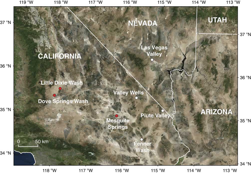
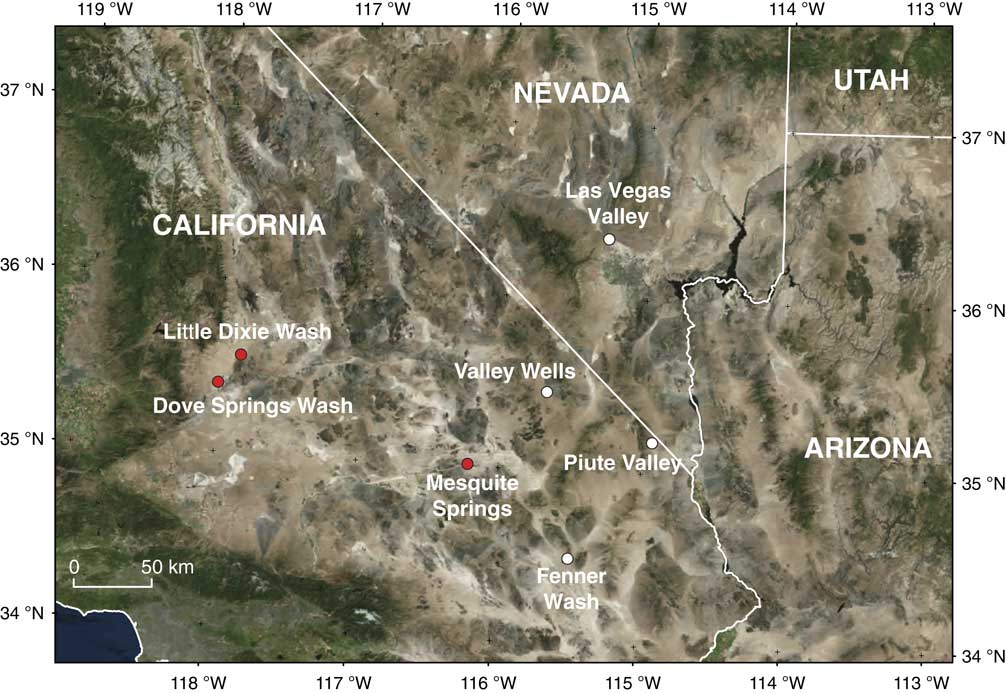
In this study, we focus on the response of desert wetlands to climatic perturbations during the YD by investigating paleowetland deposits in the Mojave Desert and southern Great Basin. Paleowetland deposits are formed in and around springs and desert wetlands, and consist of a combination of clastic sediments, chemical precipitates, and organic matter. Where preserved, they contain information on the timing and magnitude of past changes in water-table levels (Pigati et al., Reference Pigati, Rech, Quade and Bright2014). Haynes (Reference Haynes1967) was the first to show that desert wetlands (or ciénegas, as he called them) in the southwestern United States responded to past changes in climate. Subsequent studies have documented evidence of millennial-scale hydrologic changes in paleowetland systems at multiple localities in the deserts of the American Southwest (Quade, Reference Quade1986; Quade and Pratt, 1989; Quade et al., Reference Quade, Mifflin, Pratt, McCoy and Burckle1995, Reference Quade, Forester, Pratt and Carter1998, Reference Quade, Forester and Whelan2003; Haynes, Reference Haynes2007, Reference Haynes2008; Pigati et al., Reference Pigati, Bright, Shanahan and Mahan2009, Reference Pigati, Miller, Bright, Mahan, Nekola and Paces2011). Recent work in the Las Vegas Valley of southern Nevada has shown that desert wetlands are more dynamic than previously observed, having responded to abrupt climate change events on submillennial timescales (Springer et al., Reference Springer, Manker and Pigati2015, Reference Springer, Pigati, Manker and Mahan2018). Here, we show that under the right conditions, the sensitivity of desert wetlands can rival even the most highly resolved proxy systems, as paleowetland deposits at Dove Springs Wash, Mesquite Springs, and Little Dixie Wash in southern California (Fig. 1) all record multiple wet and dry cycles that fall entirely within the ~1200 year period of the YD chronozone.
Landsat image showing the locations of paleowetland deposit included in this study. Sites shown as white dots were used to evaluate potential lags in the wetland systems. Sites shown as red dots exhibit evidence of hydrologic variability that occurred within the Younger Dryas chronozone. Landsat image courtesy of the Earth Resources Observation and Science (EROS) Center. (For interpretation of the references to color in this figure legend, the reader is referred to the web version of this article.)
Study sites
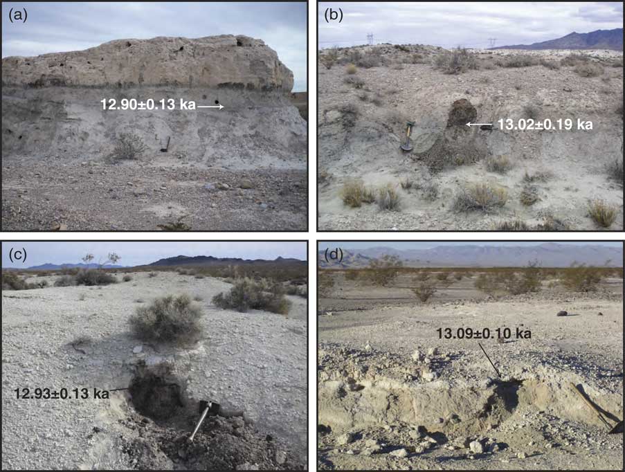
Over the past decade, our research group has sought to understand how springs and desert wetlands responded to climate change in the recent geologic past. As part of this work, we have developed stratigraphic and chronologic frameworks for paleowetland deposits at sites throughout the American Southwest. Sites were selected for this study based on the presence of a wetland stratigraphic unit that dates to the YD cold event. In the Las Vegas Valley, Nevada (Fig. 1), for example, bed E2a of the Las Vegas Formation consists of 1–2 m of massive, olive-green silts and sands (Fig. 2a) and is interpreted as representing an ancient marsh (Springer et al., Reference Springer, Pigati, Manker and Mahan2018). This unit contains charcoal and terrestrial gastropod shells (Succineidae) that previously yielded calibrated 14C ages between 12.90 and 12.35 ka (Springer et al., Reference Springer, Manker and Pigati2015), placing it squarely within the YD chronozone.
(color online) Paleowetland deposits dating to the Younger Dryas cold event and the associated basal dates of the unit at (a) Las Vegas, Nevada; (b) Valley Wells, California; (c) Piute Valley, California; and (d) Fenner Wash, California.
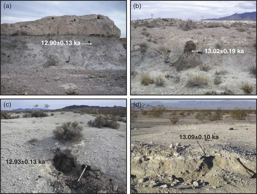
Similarly, at Valley Wells, California (Fig. 1), sediments dating to the YD consist of ~40–50 cm of olive-green silty clay that are overlain by 20–40 cm of organic-rich silt (Fig. 2b), which we interpret as representing a marsh that became choked with vegetation shortly after its inception. The base-insoluble (or “A”) fraction of the organic material previously yielded ages between 13.02 and 11.51 ka (Pigati et al., Reference Pigati, Miller, Bright, Mahan, Nekola and Paces2011), also correlative with the YD cold event.
Elsewhere, sediments at Piute Valley, California (Fig. 1) dating to the YD event consist of 20–40 cm of white diatomite (diatom-rich silt and clay) with abundant organic matter (Fig. 2c), which we interpret as representing a wetland fed by silica-rich waters. At Fenner Wash, California (Fig. 1), YD-age deposits consist of 15–20 cm of massive, white silty clay that contain Succineidae shells (Fig. 2d), which we interpret as representing a wet meadow supported by carbonate-rich water. In-stream paleowetland deposits at Dove Springs Wash and Little Dixie Wash, as well as a faulted wetland sequence at Mesquite Springs (all California; Fig. 1) were chosen for detailed stratigraphic and chronologic analysis because the deposits at each locality are unusually thick (1–5m), exhibit multiple organic-rich silts and clay interbedded with organic-poor alluvial, colluvial, or aeolian sediments that together represent a series of wet-dry cycles, and importantly, contain material suitable for radiocarbon dating. The stratigraphy and chronology of these deposits are discussed in detail below. Finally, we note that the units that were ultimately selected for study at Piute Valley, Fenner Wash, and Mesquite Spring were not known a priori to date to the YD chronozone (ages for the other four sites had been published previously). However, we targeted them for investigation based on: (1) similarities between their physical characteristics and those of bed E2a in the Las Vegas Valley and its equivalent at Valley Wells, including a lack of secondary carbonate, mottled colors, and other redoxymorphic features that tend to increase with age; (2) their position on the landscape (YD-age units are typically inset within or are lower in elevation than paleowetland units dating to the last full glacial period); and (3) the presence of charcoal, organic material, and/or terrestrial snail shells that could be used for 14C dating.
METHODS
Field methods
At each locality, we described and measured stratigraphic and sedimentologic properties of paleowetland deposits at both the outcrop scale (e.g., bedding, unit thickness, and stratigraphic relations) and hand-sample scale (e.g., grain size, sorting, and color). Field textures were determined using procedures described in the United States Department of Agriculture’s Soil Survey Manual (1951). All described sections were photographically documented, and their positions were recorded with handheld GPS units, which are reported relative to the 1984 World Geodetic System (WGS84) reference datum.
Dating methods
We used radiocarbon (14C) dating of charcoal (charred vascular plants), organic material, and small terrestrial gastropod shells of the Succineidae family establish age control for the deposits. Charcoal and organic material are recognized as suitable material for 14C dating paleowetland deposits (Quade et al., Reference Quade, Forester, Pratt and Carter1998; Haynes, Reference Haynes2008; Jull and Burr, Reference Jull and Burr2015) and were treated using the standard acid-base-acid (ABA) procedure. Previous work has shown the Succineidae shells also yield reliable 14C ages regardless of the local habitat, environmental conditions, and geologic substrate (Pigati et al., Reference Pigati, Rech and Nekola2010; Reference Pigati, McGeehin, Muhs and Bettis2013), including desert wetland ecosystems in the southwestern U.S. (Pigati et al., Reference Pigati, Bright, Shanahan and Mahan2009, Reference Pigati, Miller, Bright, Mahan, Nekola and Paces2011; Springer et al., Reference Springer, Manker and Pigati2015, Reference Springer, Pigati, Manker and Mahan2018). Clean, dry gastropod shells selected for 14C dating were broken and examined under a dissecting microscope to ensure that the interior whorls were free of secondary carbonate and detritus. Fossil shells that were free of detritus were etched with dilute HCl to remove 30–50% of the total mass prior to hydrolysis. We selected several shells at random for x-ray diffraction analysis to verify that only shell aragonite remained prior to preparation for 14C analysis. None of the shells that we analyzed contained measurable quantities of calcite.
Wetland deposits at Mesquite Springs, California did not contain sufficient carbon for processing using standard techniques, so we concentrated the organic matter by removing carbonates and siliciclastic materials. To begin, large (~250 g) mineral-rich samples were soaked in deionized (DI) water overnight and screened at 150 µm using copious amounts of deionized water to remove coarse sand and gravel. The samples were then stirred in beakers, given 3 to 5 seconds to settle, and the supernatant liquid (which contained the majority of the organic material) was then decanted and saved. This procedure removes silicates and other minerals that are denser than typical organic matter, thereby reducing the amount of acid required in subsequent steps. The samples were then centrifuged for several minutes to isolate particles larger than 8 µm in diameter and the supernatant was discarded. This was repeated until the supernatant was clear.
The resulting 8–150 μm fraction was treated initially with 1.2N HCl and allowed to react until the reaction was visually complete (~1 hr). The samples were then centrifuged, decanted, and treated overnight with 6N HCl to ensure complete removal of all carbonate minerals. After rinsing, centrifuging, and decanting again, a small amount (5 mL, to prevent a violent reaction) of concentrated HF was added to the sample and stirred using a vortex mixer to begin dissolving siliciclastic minerals. After 1 hour, additional HF was added slowly and the solution was allowed to react for at least 12 hours. The acidic solution was then decanted after centrifugation. Concentrated HF was then reintroduced to the tubes, mixed on the vortex mixer, and placed in a hot water bath at 80°C for approximately 4 hours to further remove silicates. The samples were once again centrifuged and decanted, and 6N HCl was reintroduced to the sample to prevent the precipitation of fluorides. Finally, the samples were centrifuged, decanted, and rinsed repeatedly with ASTM Type 1, 18.2 MΩ water before being placed in glass vials and dried overnight at 60°C.
Concentration of organic matter in this manner allowed the combustion, extraction, CO2 purification, and graphitization steps to proceed without the difficulties of small-sample analyses, and also permitted the direct application of standards and blank corrections (e.g., Donahue et al., Reference Donahue, Linick and Jull1990). A secondary effect of the processing is that labile and partially degraded organic matter is removed during pretreatment, further concentrating the targeted carbon pool. Previous efforts have shown that 14C ages of organic material concentrated using the procedures employed in this study are similar to ages derived from terrestrial plant macrofossils collected from the same stratigraphic horizons (Pigati et al., Reference Pigati, Reheis, McGeehin, Honke and Bright2016).
Pretreated organic samples were combusted online in the presence of excess high-purity oxygen, whereas shell carbonate was converted to CO2 using American Chemical Society (ACS) reagent grade 85% H3PO4 under vacuum at 50°C until the reaction was visibly complete (~1 hr). For all samples, water and other contaminant gases (including SOx, NOx, and halide species) were removed using a combination of cryogenic separation and high-temperature fine wire copper and silver traps. The resulting purified CO2 gas was measured manometrically and split into two aliquots. One aliquot was converted to graphite using either an iron catalyst and the standard hydrogen reduction process or catalytic reduction of CO using zinc powder (modified after Slota et al., Reference Slota, Jull, Linick and Toolin1987) and submitted for accelerator mass spectrometry (AMS) 14C analysis. For samples processed at the Arizona AMS Laboratory and the U.S. Geological Survey’s radiocarbon lab (denoted by AA and CAMS numbers, respectively, in Table 1), the second aliquot of CO2 was submitted for δ13C analysis in order to correct the measured 14C activity of the shell carbonate for isotopic fractionation. This was not required for samples processed by Aeon Laboratories, L.L.C. (denoted by Aeon numbers in Table 1).
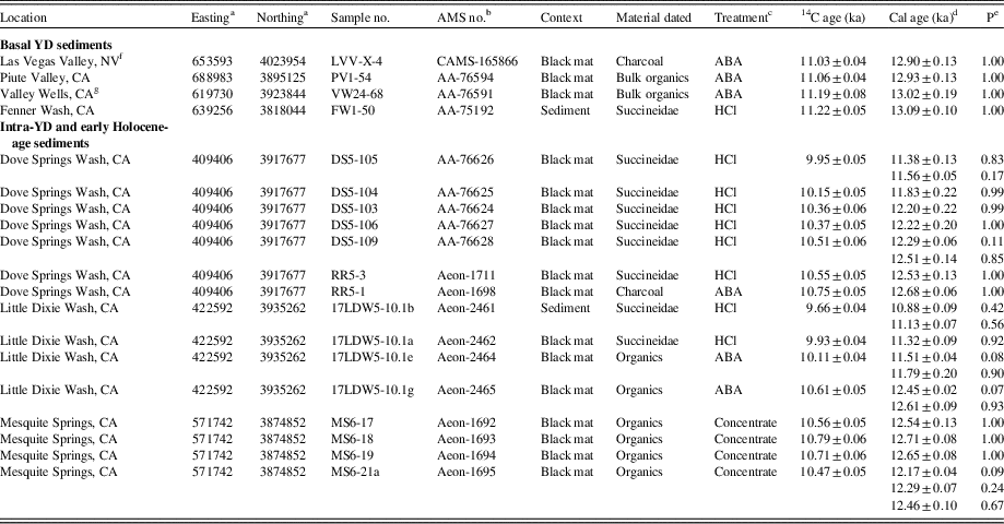
Summary of sample information, 14C ages, and calibrated ages. Uncertainties for the calibrated ages are given at the 2-sigma (95%) confidence level. All other uncertainties are given at 1-sigma (68%).
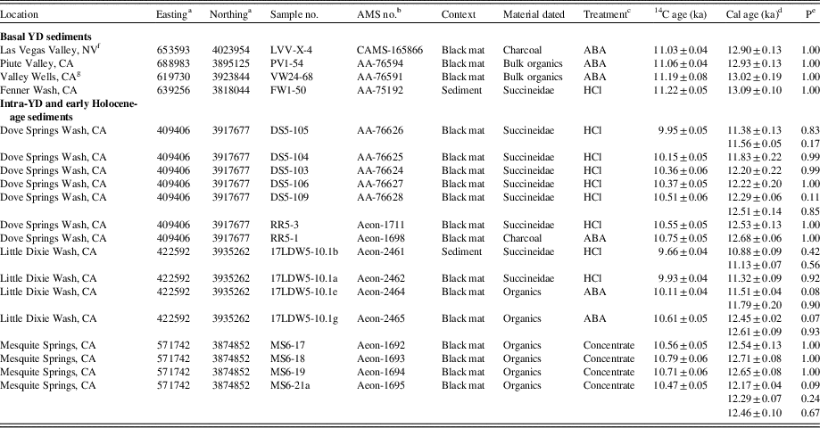
a UTM coordinates are all in zone 11S; WGS-84.
b AA, Arizona AMS Laboratory; Aeon, Aeon Laboratories, LLC; CAMS, Lawrence Livermore National Laboratory.
c ABA, acid-base-acid; HC, acid leach; concentrate, acid-HF-acid.
d Calibrated ages were calculated using CALIB v.7.1html, IntCal13.14C dataset; limit 50.0 calendar ka BP. Calibrated ages are reported as the midpoint of the calibrated range. Uncertainties are calculated as the difference between the midpoint and either the upper or lower limit of the calibrated age range, whichever is greater (reported at the 95% confidence level; 2-sigma). Multiple ages are reported when the probability of a calibrated age range exceeds 0.05.
e P=probability of the calibrated age falling within the reported range as calculated by CALIB.
f Date originally published in Springer et al. (Reference Springer, Manker and Pigati2015).
g Date originally published in Pigati et al. (Reference Pigati, Miller, Bright, Mahan, Nekola and Paces2011).
All 14C ages were calibrated using the IntCal13 dataset and CALIB 7.1html (Stuiver and Reimer, Reference Stuiver and Reimer1993; Reimer et al., Reference Reimer, Bard, Bayliss, Beck, Blackwell, Bronk Ramsey and Grootes2013). Ages are presented in thousands of calibrated years (ka) before present (BP; 0 yr BP = 1950 AD), and uncertainties are given at the 95% (2 sigma) confidence level. In the event that multiple ranges were permitted during calibration, ages discussed in the text and shown in the figures are based on the mean of the ranges weighted by their probabilities and are presented without uncertainties. For example, an age of a single calibrated range would be given as 13.09±0.10 ka, whereas it would be presented as ~13.1 ka if multiple ranges were permitted.
RESULTS AND DISCUSSION
Lag time test
Springs and wetlands in arid environments are typically fed by alluvial aquifers that are recharged by precipitation falling in nearby mountains. Water falling as rain or snow at high elevation percolates into the subsurface through fractured bedrock, enters an aquifer, and moves down gradient until it reaches the discharge area. The elapsed time between recharge and discharge is considered to be the lag time of the aquifer system.
There are two different types of lag times that could potentially affect how we evaluate hydrologic records derived from paleowetland deposits. The first is related to the time it takes for individual water molecules to enter the subsurface in the recharge area, travel through an aquifer, and emerge as discharge in a spring or wetland. This type of lag only affects records involving the chemical or physical properties of the discharging water molecules themselves, such as the isotopic composition of the water or chemical precipitates derived from the water (e.g., Devils Hole calcite; Winograd et al., Reference Winograd, Coplen, Landwehr, Riggs, Ludwig, Szabo, Colesar and Revesz1992). Since we are not measuring stable isotopes and the sample materials we used for 14C dating are not derived from groundwater, this type of lag is not relevant for this study.
The second type of lag is related to the time it takes for a pressure pulse caused by an increase in hydraulic head in the recharge area to be transmitted through an aquifer to the area of discharge. For fully confined aquifers, and assuming negligible compression of water molecules, the pressure pulse is propagated instantaneously through the aquifer. Thus, by definition, there is no lag between changes in recharge and the corresponding changes in discharge for wetlands fed by confined aquifers. For unconfined aquifers, on the other hand, at least some of the water introduced by an increase in precipitation in the recharge area is used to fill pore spaces in the aquifer that were previously empty. This could potentially slow transmission of the pressure pulse and create a temporal lag between changes in recharge and discharge. For wetlands fed by unconfined aquifers, this lag time could be on the scale of tens, hundreds, or even thousands of years, depending on the size, transmissivity, distance from source of recharge, and complexity of the aquifer system (Manga, Reference Manga1999; Fenelon and Moreo, Reference Fenelon and Moreo2002). To properly evaluate paleowetland deposits supported by unconfined aquifers, this means that the physical properties of the aquifers would have to be known a priori or be characterized in detail for every wetland system under study so that the lag time could be quantified and taken into account.
The paleowetland systems studied here are probably fed by a combination of confined and unconfined aquifers (e.g., Maxey and Jameson, Reference Maxey and Jameson1948; Harrill, Reference Harrill1976; Morgan and Dettinger, Reference Morgan and Dettinger1996; Bell et al., Reference Bell, Amelung, Ramelli and Blewitt2002). To determine if potential lags are an important consideration at our sites, we compared the basal age of bed E2a in the Las Vegas Valley and its equivalents at Valley Wells, Piute Valley, and Fenner Wash with the age of their associated climate event, the onset of the YD cold event (12.9 ka; Rasmussen et al., Reference Rasmussen, Andersen, Svensson, Steffensen, Vinther, Clausen and Siggaard-Andersen2006). At each locality, the base of the unit is clearly exposed and contains material suitable for 14C dating. We did not choose the uppermost age of the unit for comparison with the terminal age of the YD because the top of the bed is often bioturbated, eroded, or contains rootlets from younger vegetation that could compromise 14C ages. If the basal ages vary significantly between the four sites or are significantly younger than 12.9 ka, then potential lag times would have to be addressed explicitly. Conversely, if the basal ages are all ~12.9 ka, then potential lag times associated with the transmission of the pressure pulse through the aquifers are minimal and can be ignored.
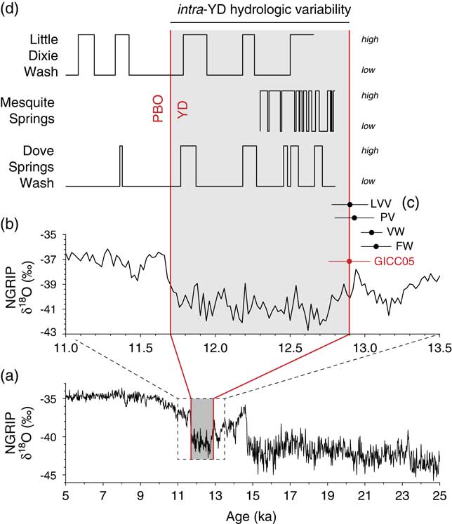
We obtained basal ages from the four sites that range from 13.09±0.10 to 12.90±0.13 ka, (Table 1; Fig. 2), which are statistically indistinguishable from each other and the age of the onset of the YD cold event. These wetland systems are fed by aquifers emanating from different mountain ranges, and are different from one another in terms of their size, elevation, gradient, lithologic composition, and, presumably, transmissivity. The similarity in the basal ages at these disparate locations shows that the wetlands responded to the abrupt change in climate associated with the YD cold event faster than we can delineate using radiocarbon dating. Based on these results, it follows that ages determined for paleowetland units can be viewed as representing the actual timing of climate change events, without having to correct for lag times, at least within the uncertainties of the 14C dating technique.
Evidence of intra-YD hydrologic variability in paleowetland deposits
Sedimentary sequences at Dove Springs Wash, Mesquite Springs, and Little Dixie Wash (all California) exhibit multiple horizons of organic-rich silts and clays, informally referred to as “black mats,” which are common features in paleowetland deposits (Quade et al., Reference Quade, Forester, Pratt and Carter1998; Haynes, Reference Haynes2008). Black mats consist of silt and clay mixed with abundant fine (5–20 μm) plant fragments, humic acids, and phytoliths from herbaceous plants that colonize emergent groundwater soon after it appears on the landscape (Harris-Parks, Reference Harris-Parks2016). Black mats typically contain 0.5–4% primary organic matter (Quade et al., Reference Quade, Forester, Pratt and Carter1998), although identifiable plant macrofossils are rarely preserved and pollen is usually heavily degraded, if it is present at all. In contrast, shells and tests of gastropods, ostracodes, and diatoms that require moist conditions and/or standing water to survive are commonly preserved in black mats. The amount of time required to form the mats is unknown, but we speculate that it is on the order of years to decades for weakly developed, lighter-colored mats, and decades to centuries for well-developed, darker-colored mats (with the difference in color determined by the amount of organic matter present). Overall, black mats in paleowetland sedimentary sequences represent times of wet ground conditions and dense vegetation supported by groundwater discharge.
At each of our sites, black mats are interbedded with inorganic sediments, including colluvial silt, sand, and gravel (Dove Springs Wash), aeolian sand (Mesquite Springs), and alluvial sand and gravel (Little Dixie Wash). These sediments do not contain plant remains, microfauna, or other evidence of groundwater discharge, and are interpreted to have been deposited under dry conditions when groundwater tables were relatively low. The presence of alternating organic-rich black mats and organic-poor sediments at these sites, therefore, represents oscillations in groundwater levels related to variable wet and dry climate conditions, a hallmark of desert wetland ecosystems (Pigati et al., Reference Pigati, Rech, Quade and Bright2014).
Dove Springs Wash
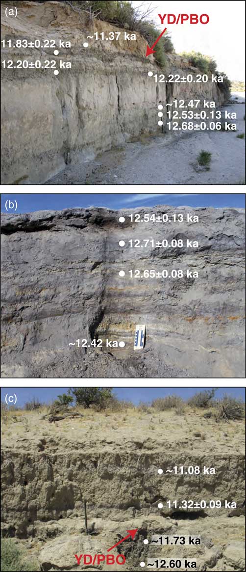
Late Quaternary sediments exposed at Dove Springs Wash in Red Rock Canyon, California, are inset into Miocene-age fluvial, lacustrine, and volcanic rocks of the Dove Spring Formation (Whistler and Burbank, Reference Whistler and Burbank1992). Sediments of the Dove Spring Formation are weakly to moderately cemented and easily eroded, leading to abundant colluvial material in the local canyons. Along a ~1 km stretch of the active Dove Springs Wash, the late Quaternary sediments are as much as 4–5 m thick, and exhibit multiple black mats interbedded with colluvial silt, sand, and gravel (Pigati et al., Reference Pigati, Latorre, Rech, Betancourt, Martínez and Budahn2012). At the outcrop shown in Figure 3a, the exposed face is a little more than 3 m thick, with an additional 1–2 m of younger, gently sloping silt and sand above. At least five distinct black mats are present in the outcrop (Fig. 4a), all of which contain abundant Succineidae shells and a variety of ostracodes indicative of cool, dilute spring discharge waters, including Candona sp. and Scottia sp., some Cypridopsis okeechobei, a few Candocyprinotus ovatus, and rare Cavernocypris wardi (ostracodes were identified by Jordon Bright, University of Arizona).
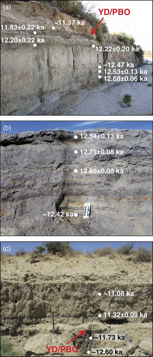
(color online) Photographs of the measured sections and calibrated 14C ages at (a) Dove Springs Wash, California; (b) Mesquite Springs, California; and (c) Little Dixie Wash, California. The boundary between the Younger Dryas (YD) cold event and Preboreal Oscillation (PBO) was determined by a combination of stratigraphic and chronologic evidence.
(color online) Detailed stratigraphic sections with locations (UTM) and calibrated 14C ages at (a) Dove Springs Wash, California; (b) Mesquite Springs, California; and (c) Little Dixie Wash, California. Note the difference in vertical scales for the different exposures. The deposits shown for Dove Springs Wash and Little Dixie Wash were both overlain by 1–2 m of gently sloping, unconsolidated sand and gravel.
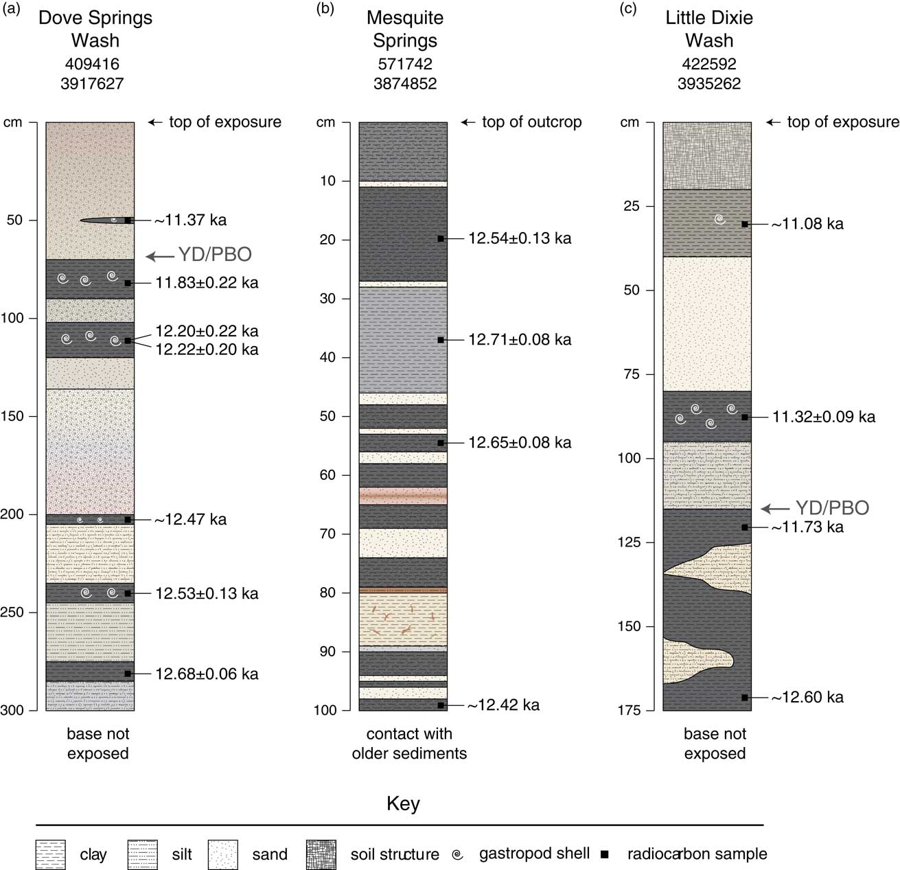
Calibrated 14C ages from Succineidae shells (n=5) and charcoal (n=1) collected from the black mats maintain stratigraphic order and range from 12.68±0.06 to ~11.37 ka, including several that fall squarely within the YD chronozone (Table 1). The calibrated ages indicate wet periods within the YD were centered at ~12.7, 12.5, 12.2, and 11.8 ka, and were separated by dry periods characterized by low water table levels that lasted ~200–400 years. Based on our measured sections and chronologic data, sedimentation rates in Dove Spring during the Younger Dryas were exceptionally high, averaging ~2.5 mm/yr. One additional calibrated 14C age (~11.37 ka; Table 1) was obtained from a Succineidae shell recovered from a thin, discontinuous black mat near the top of the exposure, which represents a brief wet period that occurred during the Preboreal oscillation (PBO; Fisher et al., Reference Fisher, Smith and Andrews2002) of the early Holocene. This indicates the variable climate conditions that prevailed during the YD cold event continued for at least a few centuries into the early Holocene in this area of the Mojave Desert. The deposits at Dove Springs Wash represents the thickest package of YD-age paleowetland sediments that we have observed anywhere in the southwestern United States.
Mesquite Springs
A series of thin black mats interbedded with light brown and reddish-brown, oxidized aeolian sand are present at Mesquite Springs, California, near the toe of a large, low-gradient, faulted alluvial fan just south of Soda Lake playa (Fig. 1). Collectively, these sediments are ~1 m thick and contain at least 10 black mats that are all less than 2–3 cm thick (Fig. 3b and 4b). Neither the black mats nor the aeolian sand contain gastropods, ostracodes, or charcoal.
We obtained four calibrated 14C ages from concentrated organic matter from the black mats that range from 12.71±0.08 to ~12.42 ka, again squarely within the YD chronozone (Table 1). These results indicate the sediments were deposited in a short amount of time, probably no more than a few centuries, but the ages do not maintain stratigraphic order, so we cannot determine the duration of each discharge episode (or the duration of dry conditions between episodes), nor can we correlate any of the individual black mats to those at our other sites. Regardless, it is clear that climate alternated rapidly and repeatedly between wet and dry conditions at this location during the Younger Dryas cold event.
Little Dixie Wash
Late Quaternary wetland deposits in the lower reaches of Little Dixie Wash, California (Fig. 1) were first investigated by Rosenthal et al. (Reference Rosenthal, Meyer, Palacios-Fest, Young, Ugan, Byrd, Gobalet and Giacomo2017) in the context of early human occupation of China Lake Basin and nearby areas. Those researchers obtained a series of radiocarbon ages from black mats exposed in several different sections in the wash that collectively date to the YD, PBO, and Holocene (n=12), including one site (their locality 3) that yielded multiple black mats that dated to the YD.
The wetland sediments in Little Dixie Wash are up to ~2 m thick, and contain multiple black mats that are interbedded with sand and gravel sourced from an alluvial fan emanating from the southern Sierra Nevada mountain range. The outcrop shown in Figures 3c and 4c is likely the same as locality 3 of Rosenthal et al. (2017), and is among the thickest sequence of sediments exposed in the wash, contains multiple black mats, and also contains Succineidae shells at two different horizons that can be utilized for radiocarbon dating. We obtained a total of four calibrated 14C ages from this section, including two from Succineidae shells and two from black mat organics, which ranged from ~12.60 to ~11.08 ka and maintained stratigraphic order (Table 1). As with Dove Springs Wash and Mesquite Springs, the wetland deposits at Little Dixie Wash record multiple wet and dry cycles within the YD chronozone, which continued into the early Holocene.
Paleowetland deposits as a high-resolution proxy record
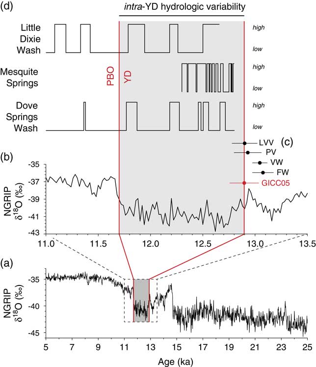
In the southwestern United States, paleowetland deposits dating to the YD chronozone are common and have been identified at sites throughout the southern Great Basin (Haynes, Reference Haynes1967; Quade, Reference Quade1986; Quade and Pratt, Reference Quade and Pratt1989, Quade et al., Reference Quade, Mifflin, Pratt, McCoy and Burckle1995, Reference Quade, Forester, Pratt and Carter1998, Reference Quade, Forester and Whelan2003; Springer et al., Reference Springer, Manker and Pigati2015, Reference Springer, Pigati, Manker and Mahan2018), Mojave Desert (Pigati et al., Reference Pigati, Miller, Bright, Mahan, Nekola and Paces2011), and Sonoran Desert (Haynes, Reference Haynes2007; Ballenger et al., Reference Ballenger, Holliday, Kowler, Reitze, Prasciunas, Miller and Windingstad2011). At most of these locations, the YD-age deposits are a few centimeters to a few tens of centimeters thick, and are often bioturbated, which limits their potential temporal resolution. The three sites studied here in detail, Dove Springs Wash, Mesquite Springs, and Little Dixie Wash, California, are unusual in that they all exhibit extremely high sedimentation rates (up to ~2.5 mm/yr), which allows for a higher temporal resolution than is typically achieved in wetland settings (Fig. 5). As researchers continue to discover and investigate new outcrops and exposures of paleowetland deposits in the region, we anticipate that additional high-resolution records rivaling or exceeding those presented here will come to light for a variety of time periods, not just the YD cold event.
(color online) North Greenland Ice Core Project (NGRIP) δ18O data using the GICC05 chronology (Svensson et al., 2008) for the time periods (a) 25–5 ka and (b) 13.5–11.0 ka. (c) Basal ages for bed E2a of the Las Vegas Formation in the Las Vegas Valley (2018) and its equivalents in Valley Wells (VW; Pigati et al., 2011), Piute Valley (PV; this study), and Fenner Wash (FW; this study) compared to the onset of the Younger Dryas (YD) cold event (Rasmussen et al., 2006). Dark filled circles represent calibrated radiocarbon ages with uncertainties presented at the 95% (2-sigma) confidence level; the red filled circle and associated error bars denote the timing (12.896 ka) and associated maximum counting errors (0.138 ka; equivalent to 2-sigma) for the initiation of the Younger Dryas (Andersen et al., 2006). (d) Hydrographs showing relative groundwater levels at Dove Springs Wash, Mesquite Springs, and Little Dixie Wash (all California). High water table levels represent periods of active groundwater discharge and formation of organic-rich black mats (see Fig. 3 and 4), whereas low water table levels represent deposition of aeolian, alluvial, or colluvial sediments under dry conditions. Each period of high water table conditions at Dove Springs Wash and Little Dixie Wash are radiocarbon dated, whereas the entirety of the Mesquite Springs record was assigned to the interval 12.8–12.3 ka based on dating of concentrated organic matter. The width of the wet and dry cycles at each site are scaled to the site stratigraphy with the idea that thick black mats require more time to develop than thin mats. YD, Younger Dryas; PBO, Pre-Boreal Oscillation.
What might be responsible for driving high-frequency hydrologic or climatic changes during the YD cold event? Only a few researchers have speculated on potential drivers of intra-YD variability, thus far with little consensus or agreement. Proposed drivers for intra-YD variability include fluctuations in the input of freshwater to the North Atlantic (Carlson et al., Reference Carlson, Clark, Haley, Klinkhammer, Simmons, Brook and Meissner2007), storm track changes related to sea-ice extent and salinity in the North Atlantic (Bakke et al., Reference Bakke, Lie, Heegaard, Dokken, Haug, Birks, Dulski and Nilsen2009), and perturbations in the Atlantic meridional overturning circulation resulting in changes in transport of heat from the equator to higher latitudes (Vincent and Cwynar, Reference Vincent and Cwynar2016). The impact of each of these processes would be greatest in and around the North Atlantic, and would presumably decrease with distance from the region. If one or more of these mechanisms were responsible for the high-resolution changes observed in the North Atlantic proxy records and also influenced climate conditions in the southwestern United States, this would imply that some type of quickly transmitted teleconnection existed between the two regions, possibly related to reorganizations of atmospheric circulation patterns, since the variations are all temporally within the YD chronozone.
As an alternative, Liu et al. (Reference Liu, Wang, Cheng, Kong and Chen2013) cited similarities in the temporal frequencies of isotopic changes in their speleothem record at Qingtian Cave, China, variations in the combined 10Be flux in the GISP2 and GRIP ice cores (Muscheler et al., Reference Muscheler, Beer, Wagner, Laj, Kissel, Raisbeck, Yiou and Kubik2004), and the 205-year periodicity of the solar de Vries cycle (Bond et al., Reference Bond, Kromer, Beer, Muscheler, Evans, Showers, Hoffmann, Lotti-Bond, Hajdas and Bonani2001; Wagner et al., Reference Wagner, Beer, Masarik, Muscheler, Kubik, Mende, Laj, Raisbeck and Yiou2001) as evidence for centennial-scale solar activity as a possible forcing mechanism. This would affect ecosystems and hydrologic processes worldwide without regard for proximity to the North Atlantic, and would not require transmission of changes in physical states or properties through teleconnections between disparate regions.
In the Mojave Desert and southern Great Basin, there are discrepancies between different hydrologic systems regarding the nature of the YD cold event as a whole, and essentially no speculation as to the drivers of intra-YD variability. Lake records along the Mojave River system, for example, seem to suggest a reduction in winter precipitation and an overall return to drier conditions during the YD (Kirby et al., Reference Kirby, Knell, Anderson, Lachniet, Palermo, Eeg and Lucero2015; Glover, et al., 2017), whereas a speleothem record from Leviathan Cave, Nevada, indicates a shift to colder temperatures (Lachniet et al., Reference Lachniet, Denniston, Asmerom and Polyak2014) and wetland systems throughout the region clearly show that wet conditions prevailed at this time (Haynes, Reference Haynes1967; Quade, Reference Quade1986; Quade and Pratt, Reference Quade and Pratt1989; Quade et al., Reference Quade, Mifflin, Pratt, McCoy and Burckle1995, Reference Quade, Forester, Pratt and Carter1998, Reference Quade, Forester and Whelan2003; Pigati et al., Reference Pigati, Miller, Bright, Mahan, Nekola and Paces2011; Springer et al., Reference Springer, Manker and Pigati2015, Reference Springer, Pigati, Manker and Mahan2018). In our view, it is premature to speculate about potential drivers of intra-YD hydrologic variability in the southwestern United States (and probably worldwide) until more high-resolution records are developed. We expect, however, that additional work on paleowetland deposits and other hydrologic systems over large geographic areas will shed light on what was ultimately responsible for the unstable climate within the YD cold event.
CONCLUSIONS
Paleowetland deposits are common features in the deserts of the American Southwest and can be queried on a variety of spatial and temporal scales. Researchers have known that wetlands responded to climate change on at least glacial-to-interglacial cycles for more than half a century, and recent work has demonstrated that they respond even faster, on millennial and submillennial timescales. Here, we have shown that paleowetland deposits record hydrologic changes on centennial, and possibly decadal, timescales in areas where sedimentation rates are unusually high. Wetland deposits at Dove Springs Wash, Mesquite Springs, and Little Dixie Wash, all located in the Mojave Desert of southern California, exhibit evidence of multiple wet and dry cycles in the form of organic-rich black mats interbedded with colluvial, aeolian, and alluvial sediments that fall temporally within the YD chronozone. These results mark the first time that intra-YD variability has been documented in paleowetland deposits, and is the only terrestrial proxy record in the southwestern United States thus far that shows unequivocal evidence of significant climate or hydrologic variability within the YD chronozone.
Our results show that desert wetland ecosystems are extremely sensitive to climate change, and respond to climatic perturbations on timescales that are relevant to human society. Given that springs and desert wetlands are home to many threatened and endangered species, these results can inform efforts to manage and preserve these fragile ecosystems in light of the potential range of environmental changes forecasted for the near future.
ACKNOWLEDGMENTS
We thank the management and staff at Tule Springs Fossils Beds National Monument (TUSK) for their support and continued access under permit TUSK-2015-SCI-001 (to KBS). We thank Lesleigh Anderson, Adam Hudson, an anonymous reviewer, and Janet Slate who provided constructive reviews of this manuscript. We also thank Jordon Bright (University of Arizona) for identifying the ostracodes from Dove Springs Wash and Paco van Sistine (USGS) for assistance with the site location figure. This project was funded in part by the United States Geological Survey’s Climate and Land Use Change Research and Development Program through the Paleohydrology of Desert Wetlands project. Any use of trade, product, or firm names is for descriptive purposes only and does not imply endorsement by the United States Government.