1. INTRODUCTION
Location information of mobile nodes including pedestrians has become one of the most important data that yields higher value-added services such as Location-Based Services (LBS) (Kolodziej and Hjelm, Reference Kolodziej and Hjelm2006; Xue et al., Reference Xue, Shi and Dong2012; Ahn and Ko, Reference Ahn and Ko2009). The most popular localisation method is to use the Global Positioning System (GPS). In outdoor areas, the mobile node such as smart phone or tablet PC containing a GPS chipset can easily provide the location information with a bounded error. However, the GPS signal cannot be used in indoor environments due to signal blockage or weakness (Kaplan, Reference Kaplan1996). In indoor environments, infra-based wireless localisation technologies can be used instead of GPS (Hazas et al., Reference Hazas, Scott and Krumm2004; Hightower and Borriello, Reference Hightower and Borriello2001). The wireless localisation infra includes Wi-Fi (Cho, Reference Cho2010; Kitasuka et al., Reference Kitasuka, Nakanishi and Fukuda2003), ZigBee (Sugano et al., Reference Sugano, Kawazoe, Ohta and Murata2006), Ultra Wideband (UWB) (Navarro and Najar, Reference Navarro and Najar2011; Chen et al., Reference Chen, Wang, Wang, So and Poor2012; Poturalski et al., Reference Poturalski, Flury, Papadimitratos, Hubaux and Le Boudec2012; Shen et al., Reference Shen, Molisch and Salmi2012; Cho and Choi Reference Cho and Choi2010), Chirp Spread Spectrum (CSS) (Hur and Ahn, Reference Hur and Ahn2010; Kang et al., Reference Kang, Seo and Lee2009; Cho and Kim, Reference Cho and Kim2010) and so on (Zhou and Pollard, Reference Zhou and Pollard2006; Park and Lee, Reference Park and Lee2013; Song et al., Reference Song, Shin and Jeon2012). To localise the mobile node based on the wireless infra, the mobile node has to measure some data such as Time of Arrival (ToA) (Navarro and Najar, Reference Navarro and Najar2011; Shen et al., Reference Shen, Molisch and Salmi2012; Jhi et al., Reference Jhi, Chen, Lin and Huang2012), Time Difference of Arrival (TDoA) (Yu et al., Reference Yu, Huang, Gao and Liu2012), Round Trip Time (RTT), Angle of Arrival (AoA) (Navarro and Najar, Reference Navarro and Najar2011; Lu and Wu, Reference Lu and Wu2012) or Received Signal Strength (RSS) (Sugano et al., Reference Sugano, Kawazoe, Ohta and Murata2006; Salman et al., Reference Salman, Ghogho and Kemp2012; Wang et al., Reference Wang, Chen, Li and Jin2012). These data are used to localise the mobile node based on a wireless localisation algorithms such as trilateration, triangulation, cell-ID, fingerprinting or Kalman filtering.
A common and critical problem in the implementation of wireless localisation is that there could be lots of measurement errors including multipath errors as well as thermal noise. It is certain that the measurement contaminated by these errors degrades the localisation performance (Ahn and Ko, Reference Ahn and Ko2009). It is well known that UWB or CSS-based range measurement is very accurate owing to the physical layer (PHY) characteristics (Hur and Ahn, Reference Hur and Ahn2010). Moreover, it is easy to obtain the range data through measuring the RTT using UWB or CSS module without time synchronisation. In this paper, CSS is selected because it is easy to buy the chipset in the commercial market.
A common approach of the conventional wireless localisation technologies is to localise the mobile node based on the fixed reference nodes with known location data. However, it is difficult to set the reference nodes for wireless localisation in special environments such as the scene of a battle; besides it is assumed that GPS cannot be used owing to jamming signals. In this environment, location information for soldiers is very important for safe conduct of operations. To provide a good localisation solution for a group of soldiers, a concept of mobile wireless sensor network (MWSN) is employed in this paper. It is assumed that there is no anchor node in the area where the MWSN is applied. Each mobile node contains a CSS chipset with a different identification (ID). Among the mobile nodes, Peer-To-Peer (P2P) ranging is processed periodically. The connection data, including the IDs of connected nodes, measuring range data, and local connection time must be gathered in a searching node possessed by a commander who wants to find the location of his troops. Then, the searching node estimates the location of the mobile nodes using the gathered data based on a proper localisation algorithm. This is one scenario for application of this system.
However, it is difficult to achieve the iterative P2P ranging and fast data transformation using single channel CSS chipsets on the MWSN successfully. Another problem occurs in the conventional localisation algorithms due to the errors caused in the linearization process of a nonlinear ranging equation and bad geographic relationship among the reference nodes and mobile node to be localised. For example, the Iterative Least Ssquares (ILS) method may give rise to two problems: one is the local minimum problem and the other is high computational burden owing to the iteration process (Cho and Choi, Reference Cho and Choi2010). In the Direct Solution (DS) method, both candidate solutions have large errors in specific situations (Cho and Kim, Reference Cho and Kim2013).
Motivated by these problems, a simple but practical implementation technology for localising a group of mobile nodes is established in this paper. The implementation technology includes the P2P ranging and connection data sharing procedures for the MWSN with single channel CSS chipsets and an adaptive localisation algorithm that can avoid the problems occurring in the conventional localisation algorithms by taking the features of the CSS chipset and simulation results of conventional localisation algorithms into account. To verify the performance of the presented procedures and algorithm, a localisation system prototype is developed using CSS chipsets. Then, actual tests are performed using the system.
This paper is structured as follows. In Section 2, simple P2P ranging and connection data sharing procedures are established. In Section 3, an adaptive localisation algorithm is addressed and the developed localisation system is described in Section 4. Experimental tests are conducted to validate the proposed implementation technology in Section 5, and the paper is concluded in the final section.
2. MWSN-BASED P2P RANGING AND DATA SHARING PROCEDURES FOR LOCALISATION
2.1. Concept of MWSN-based localisation
Figure 1 shows the concept of MWSN for localisation of the mobile nodes. It is supposed that several pedestrians with a mobile node move freely in a searching area where there is no anchor node that can be used for localisation. Each mobile node has its own coverage and tries to connect with all of the mobile nodes located in the coverage for ranging and sharing the connection data periodically. All the connection data can be shared among mobile nodes as time passes and can be updated cyclically. This is the concept of MWSN defined in this paper. That is, there is no anchor node. For localising the mobile nodes, connection information among the mobile nodes is used instead of connection information among anchor nodes and mobile nodes.
Concept of MWSN for localisation of the mobile nodes.

When an observer or commander in the group of pedestrians possessing the mobile node wants to search the mobile nodes, he places a mobile node0 on the right side of him at intervals of several metres and turns on a searching node. The searching node and mobile node0 start to connect with the mobile nodes in their own coverage. Consequently, the connection data is gathered in the searching node and is updated periodically. Only using the connection data, the searching node estimates the location of the mobile nodes.
This is the basic idea for anchor-free localisation presented in this paper. It is obvious that accurate ranging and fast data sharing are required for accurate and fast periodic localisation. To achieve accurate ranging, UWB or CSS can be used. In this paper, CSS is selected by reason of easy purchase in the commercial market. However, it is difficult to quickly share the connection data in the case of multi-nodes owing to there being only a single channel in the CSS chipset. During actual experiments, this phenomenon has been observed frequently. Thus, it is obvious that the localisation performance will be enhanced if the ranging and data sharing performance can be improved. Based on this motivation, new P2P ranging and connection data sharing procedures are presented in this section, based on some heuristic features of the CSS chipset.
2.2. RTT-based Ranging
The ranging technique outlined in IEEE 802.15.4a, which is the standard for CSS, is called Symmetric Double-Sided two way ranging (SDS-TWR) and is one of methods for measuring RTT (Ahn and Ko, Reference Ahn and Ko2009). RTT error is caused by a clock error in the CSS chipset. The RTT error of the SDS-TWR method is less than that of the other methods. Therefore, the SDS-TWR method is used in this paper.
Figure 2 shows the concept of the SDS-TWR method. RTT can be calculated as
 $$t_{rt} = \displaystyle{{t_{r(1)} - t_{d(2)} + t_{r(2)} - t_{d(1)}} \over 2}$$
where t r(i) is a round trip time with delay time and t d(i) is a delay time in the CSS module i. t rt is a RTT without delay time.
Concept of the SDS-TWR method.
Ranging can be achieved as
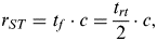 $$r_{ST} = t_f \cdot c = \displaystyle{{t_{rt}} \over 2} \cdot c,$$
where t f is flight time from a CSS module to another CSS module, r ST is the measured range date based on the SDS-TWR method, and c is light speed.
Inserting Equation (1) into (2) and adding clock errors, ranging error can be calculated as
 $$\eqalign{\tilde r_{ST} & = \displaystyle{{t_{r(1)} + t_{r(2)} - t_{d(1)} - t_{d(2)}} \over 4}c + \displaystyle{{(\delta _{1 - 1} - \delta _{1 - 2} ) + (\delta _{2 - 2} - \delta _{2 - 1} )} \over 4}c \cr & \equiv r_{ST} + \delta r_{ST}} $$
where  $\tilde r_{ST} $ is measured range data with error due to the clock error, δ i-i is a clock error caused by the CSS module i in the calculation of t r(i) and δ j-i is a clock error caused by the CSS module j in the calculation of t d(j). r ST and δr ST are true range data and range measurement error, respectively.
In Equation (3), δ i-i is almost equal to δ i-j over a short time. Therefore, accurate ranging can be achieved by the SDS-TWR method.
2.3. P2P Ranging Procedure
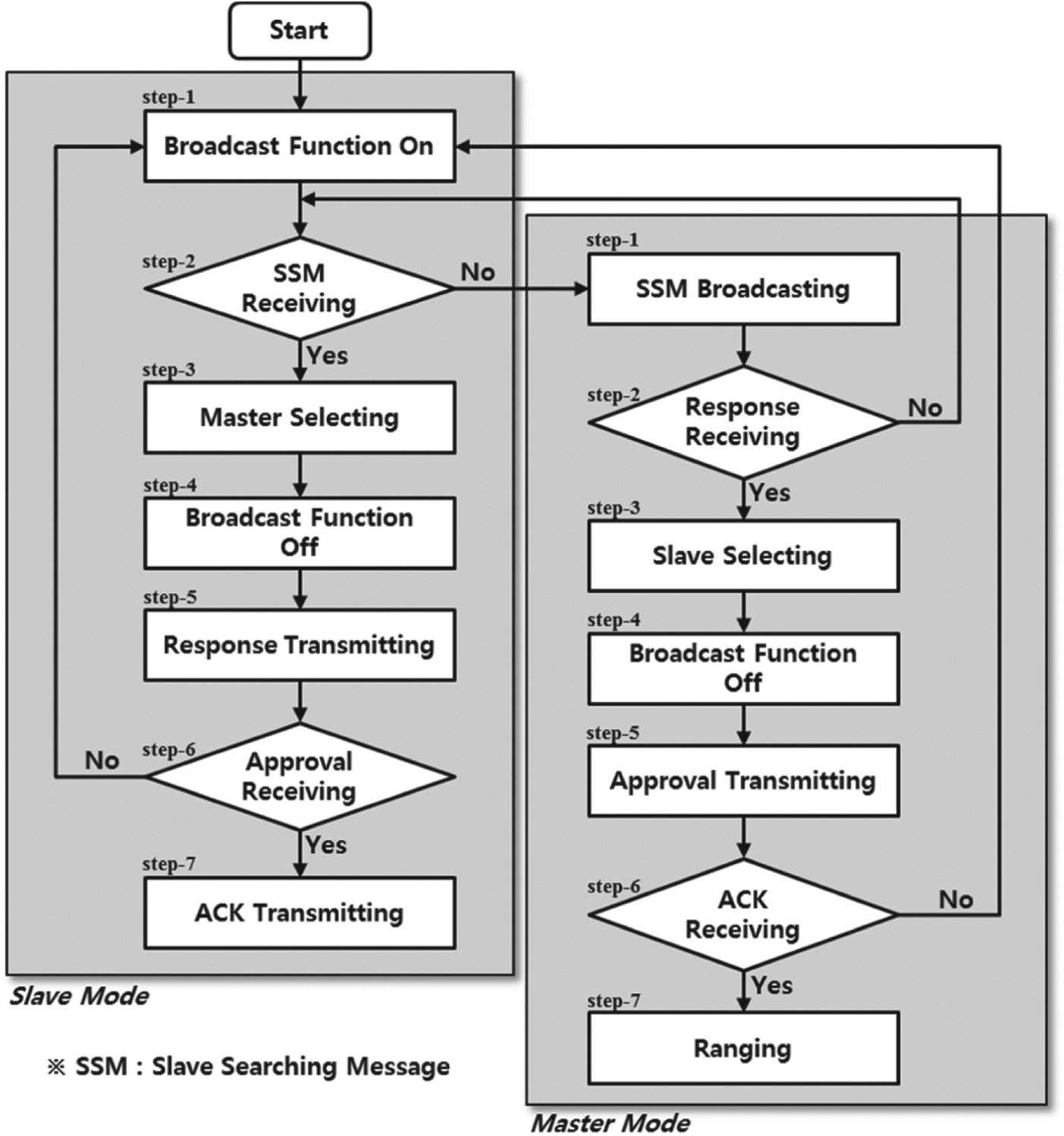
Each node in a group has periodic connections with other nodes in its own coverage individually. In these connections, ranging between two nodes connected to each other is performed based on the SDS-TWR method. To achieve this, a P2P ranging procedure is established as shown in Figure 3.
P2P ranging procedure.
First, a structure of connection data is designed as [ID of master node; ID of slave node; measured range data; local connection time]. The mode of each mobile node is set as slave mode operating broadcast function. The mobile node waits to receive slave searching messages for a while. If the waiting time expires without receiving any slave searching message, the mode of the mobile node is changed to master mode. The searching node operates only as master mode. Each node operates according to the following procedure as master mode or slave mode. The procedure for a master mode in the P2P ranging procedure is as follows: In Step 1, the master node broadcasts a slave searching message whose destination ID is not important. In Step 2, the master node waits to receive response messages from surrounding slave nodes for a while. If the waiting time expires without receiving any response message, the node is initialised to slave mode. The waiting time is set previously through a heuristic approach (e.g. 1 ms). If the master node receives two or more response messages from the surrounding nodes in Step 3, one of them is selected based on the connection data. The priority of a new connection is high. Among the update connections, one whose update time is earliest has high priority. In Step 4, the master node deactivates the broadcast function, that is the node can receive only messages whose destination ID is equal to the ID of the node. The master node transmits an approval message to the selected slave node in Step 5. In Step 6, the master node waits for an acknowledgment (ACK) message from the selected slave node for a while. If the waiting time expires without receiving an ACK message, the node is initialised as slave mode to avoid communication breakdown due to interference in the single channel. After receiving an ACK message, ranging is performed between the connected nodes based on the SDS-TWR method in the final step.
The procedure for a slave mode in the P2P ranging procedure is as follows: In Step 1, the slave node can receive every message regardless of the destination ID. In Step 2, the slave node waits to receive the slave searching messages. If the waiting time expires without receiving any slave searching message, the mode of the slave node is changed to master mode. If the slave node receives two or more slave searching messages from the surrounding nodes, one of them is selected based on the connection data in Step 3. The priority of a new connection is high. Among the update connections, one whose update time is earliest has highest priority. In Step 4, the slave node deactivates the broadcast function, that is the node can receive only messages whose destination ID is equal to the ID of the node. In Step 5, the slave node transmits a response message to the selected master node. The slave node waits for an approval message from the selected master node for a while in Step 6. If the waiting time expires without receiving an approval message, the node is initialised to avoid communication breakdown due to interference in the single channel. After receiving an approval message from the selected master node, the slave node transmits an ACK message to the master node in the final step.
2.4. Connection Data Sharing Procedure
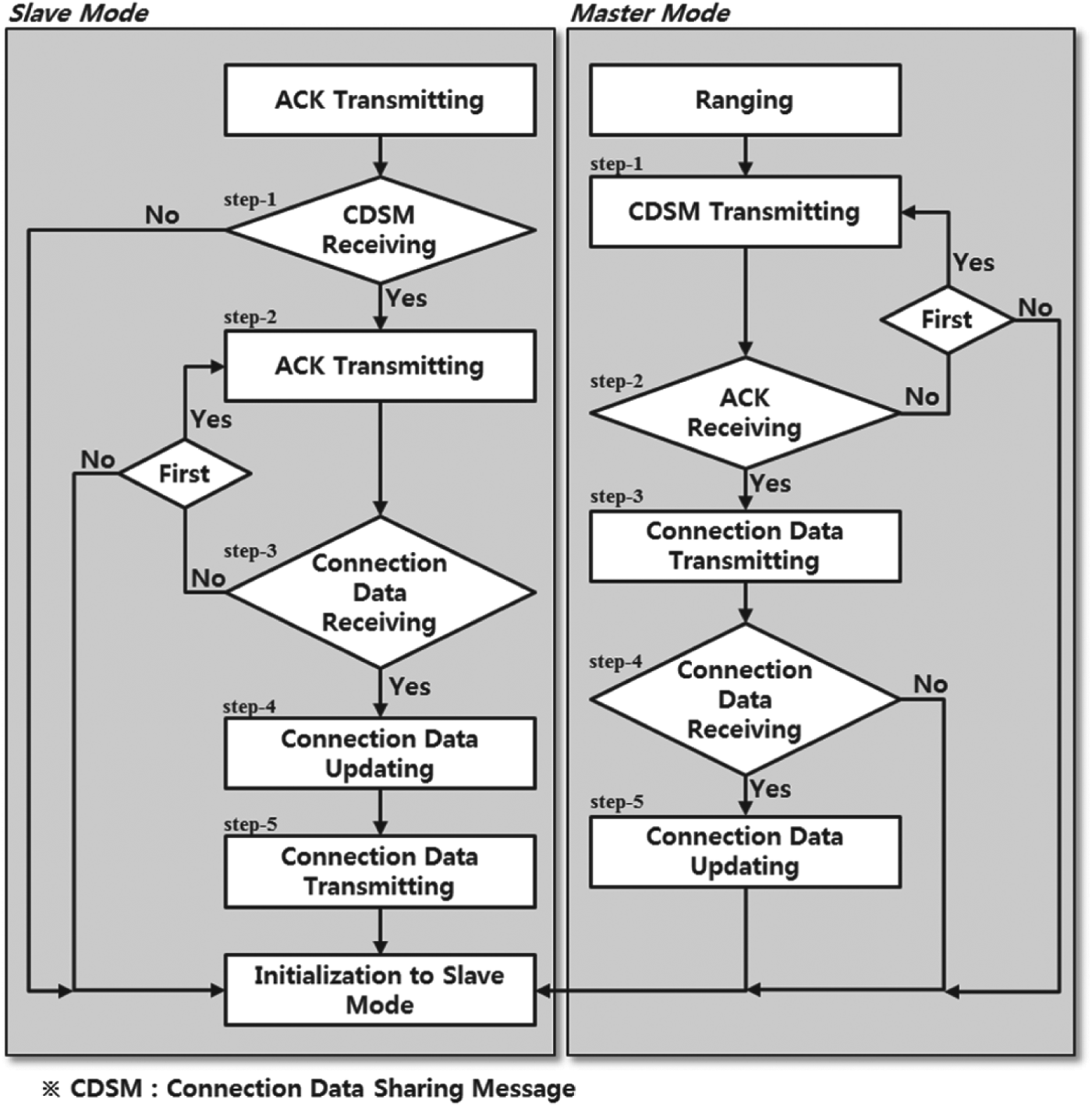
After processing the P2P ranging procedure successfully, a connection data sharing procedure is performed as shown in Figure 4. The procedure for a master mode in the connection data sharing procedure is as follows: After ranging, the master node transmits a connection data-sharing message to the slave node in Step 1. In the next step, the master node waits to receive an ACK message from the slave node for a while. If the waiting time expires without receiving an ACK message, the master node transmits one more connection data-sharing message. If the master node cannot receive any ACK message, the node is initialised to slave mode. After receiving an ACK message from the slave node, the master node transmits a set of connection data saved in the master node in Step 3. In Step 4, the master node waits to receive a set of connection data from the slave node for a while. If the waiting time expires without receiving any connection data, the node is initialised to slave mode, then communication breakdown owing to interference in the single channel can be avoided. After receiving the connection data of the slave node, the connection data of the master node is updated in the final step. Then, the node is initialised a slave mode.
Connection data sharing procedure.
The procedure for a slave mode in the connection data sharing procedure is as follows: After transmitting an ACK message in the P2P ranging step, the slave node waits to receive a connection data sharing message from the master node in the first step. If the waiting time expires without receiving a connection data-sharing message, the node is initialised. In Step 2, the slave node transmits an ACK message for starting the connection data sharing procedure. In the next step, the slave node waits to receive a set of connection data from the master node for a while. If the waiting time expires without receiving the connection data, the slave node transmits one more ACK message. If the slave node cannot receive any connection data, the node is initialised to avoid communication breakdown due to interference in the single channel. After receiving a set of connection data from the master node, the connection data of the slave node is updated in Step 4. In the final step, the slave node transmits a set of the latest connection data made by comparing the original connection data saved in its own node and the connection data received in Step 3. Then, the node is initialised.
3. ADAPTIVE LOCALISATION ALGORITHM
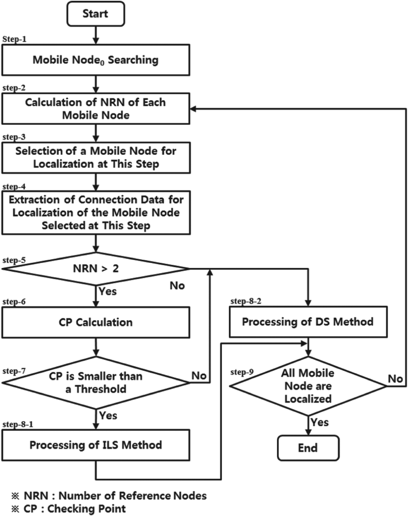
The connection data can be stored in the memory of the searching node and can be updated periodically as time passes through real-time processing of the P2P ranging procedure and the connection data sharing procedure. The searching node estimates the location of the mobile nodes using the connection data based on an adaptive localisation algorithm as shown in Figure 5.
Adaptive localisation algorithm.
It is supposed that multi-mobile nodes are processing at the scene of the operation. To localise the mobile nodes, an observer or commander possessing the searching node puts a mobile node whose ID is 0 on the x-axis of his right side first. This mobile node can be considered as a kind of a virtual anchor node in the local coordinate frame. Thus, the relative direction of the mobile nodes from the searching node can be calculated. After this act, the observer pushes the start button on the searching node to process the following adaptive localisation algorithm.
In Step 1, the searching node measures a range data between the mobile node0 and itself through processing the P2P ranging procedure. Then the locations of the searching node and mobile node0 are set equal to (r s,0, 0·0001 m) and (0·0001 m, 0·0001 m), respectivelyFootnote 1. In the next step, the number of reference nodes of each mobile node are calculated using the connection data. Reference node denotes a node with a location solution; that is, the mobile nodes localised in the previous steps and the searching node can be a reference node. The reference node is considered as a mobile anchor node. The mobile nodes are localised sequentially according to the numbers of reference nodes. In Step 3, a mobile node whose number of reference nodes is largest is selected for localisation at this step. The connection data corresponding to the mobile node selected at Step 3 is extracted for localisation in Step 4. The connection data includes the ranging data between the reference nodes and mobile node to be localised at this step and location data of the reference nodes. Then, the mobile node is localised based on a proper estimation method.
There are several methods such as the Iterative Least Squares (ILS) method, Direct Solution (DS) method, etc. for estimating the location parameter from the nonlinear ranging equation. In Step 5, the number of reference nodes of the selected mobile node is checked. If the number of reference nodes is larger than two, one of these methods can be used. The ILS method may yield two problems: one is a local minimum problem and the other is high computational burden owing to the iteration process. The local minimum problem can be solved using an appropriate method (Cho and Choi, Reference Cho and Choi2010). To solve the second problem, the DS method can be used (Biton et al., Reference Biton, Koifman and Bar-Itzhack1998). However, the DS method has another problem in that it yields two candidate solutions. Generally, one of them is near the true location and the other is far from the true location. So, it is easy to select the correct solution. In specific situations, however, both candidate solutions are far from the true location. This phenomenon can occur due to bad relative locations of the reference nodes and mobile node. To check whether the problem occurs, a checking point is inspected in Step 6. The checking point is selected for checking the possibility of complex numbers of localised solutions. The checking point is used in localisation Equation (12) and is calculated as
 $$Checking\,Poin\,t = b^2 - 4ac,$$
where
 $$a = (LR_b )^T (LR_b ),$$
 $$b = 2(LR_a )^T (LR_b ) - 1,$$
 $$c = (LR_a )^T (LR_a ),$$
where
 $$L = (H^T H)^{ - 1} H^T, $$
 $$R_a = \left[ {\matrix{ {r_{1,m}^2 - (x_1^2 + y_1^2 )} \cr \vdots \cr {r_{n,m}^2 - (x_n^2 + y_n^2 )} \cr}} \right],$$
 $$R_b = [\overbrace {\matrix{ { - 1} & \cdots & { - 1} \cr}} ^n]^T, $$
where n is the number of reference nodes, [x iyi]T is the location of the reference node i, r i,m is a measured range data between the reference node i and selected mobile node for localisation, and
 $$H = \left[ {\matrix{ { - 2x_1} & { - 2y_1} \cr \vdots & \vdots \cr { - 2x_n} & { - 2y_n} \cr}} \right].$$
Figure 6 shows the estimation problem caused in the DS method. Simulation conditions are as follows:
DS method estimation problem.
• location of mobile node0: (10·0 m, 0·0001 m) ;
• estimated location of mobile node1: (5·0 m, 12·0 m);
• simulation area for localisation: (2·0 m, 20·0 m, 2·0 m, 20·0 m);
• localisation interval: 1·0 m;
• number of Monte-Carlo simulations: 100;
• reference nodes: searching node, mobile node0 and mobile node1; and
• ranging error: N(0·0 m, 0·3 m).
Under this simulation condition, the checking point in the simulation area is denoted in Figure 6(a). The estimates of the mobile nodes on the localisation points are denoted in Figure 6(b). As shown in this figure, the checking points are close to zero in the area surrounding the straight line connecting mobile node0 and mobile node1. As a result, the DS method yields wrong estimates in the area where the checking point is close to zero as shown in Figure 6(b) because the square root of the checking point is used in the localisation Equation (12).
To avoid this problem, the ILS method is chosen when the calculated checking point is smaller than a threshold in Step 7. Otherwise, the DS method is chosen. The threshold is set to 0·15 heuristically based on Figure 6. In Step 8-1, a mobile node is localised using the ILS method as
 $$\left[ {\matrix{ {\hat x_m} \cr {\hat y_m} \cr}} \right] = \left[ {\matrix{ {\hat x_m^ *} \cr {\hat y_m^ *} \cr}} \right] + (M^T M)^{ - 1} M^T \delta R,$$
where  $[\matrix{ {\hat x_m^ * } \tab {\hat y_m^ * } \cr} ]^T $ is a nominal point for linearization of a nonlinear ranging equation,
 $$M = \left[ {\matrix{ {\displaystyle{{\hat x_m^ * - x_1} \over {\hat r_{m,1}}}} & {\displaystyle{{\hat y_m^ * - y_1} \over {\hat r_{m,1}}}} \cr \vdots & \vdots \cr {\displaystyle{{\hat x_m^ * - x_n} \over {\hat r_{m,n}}}} & {\displaystyle{{\hat y_m^ * - y_n} \over {\hat r_{m,n}}}} \cr}} \right]$$
 $$\delta R = \left[ {\matrix{ {\tilde r_{m,1} - \hat r_{m,1}} \cr \vdots \cr {\tilde r_{m,n} - \hat r_{m,n}} \cr}} \right],\,{\rm and}$$
 $$\hat r_{m,i} = \sqrt {(x_i - \hat x_m^ * )^2 + (y_i - \hat y_m^ * )^2}, $$
where  $\tilde r_{m,i} $ is measured range data between the mobile node and reference node i.
The estimated value in Equation (8) is set as a new nominal point then the above process is iterated until the estimated value converges into a true value.
In Step 8-2, the DS method is processed. In the DS method, there are two candidate solutions as (Biton et al., Reference Biton, Koifman and Bar-Itzhack1998)
 $$\left[ {\matrix{ {\hat x_m (k)} \cr {\hat y_m (k)} \cr}} \right] = L\left( {R_a + R_b \displaystyle{{ - b + ( - 1)^k \sqrt {CP}} \over {2a}}} \right),$$
where k∈{1, 2}.
If the number of reference nodes is larger than two, a correct solution is selected whose residual is smaller than the other. The residuals are calculated as
 $$e(k) = \sqrt {\displaystyle{1 \over n}\sum\limits_{i - 1}^n {\left( {r_{i,m} - \sqrt {\left( {x_i - \hat x_m (k)} \right)^2 + \left( {y_i - \hat y_m (k)} \right)^2}} \right)}}. $$
If the number of reference nodes is equal to two, a correct solution cannot be chosen based on the residual check. In this case, two rules are employed. First, it is assumed that all of the mobile nodes are in front of the searching node, that is ŷ m>0. Also, if both candidate solutions satisfy the first rule, a candidate solution that isn't located within coverage of the pre-localised mobile nodes that are not included in the reference nodes for this step is selected as a correct solution.
If all of the mobile nodes are localised, the adaptive localisation algorithm is terminated in the final step. Otherwise, the previous steps are iterated from Step 2.
Figure 7 shows the results of the adaptive localisation algorithm. By comparing Figure 7(a) with Figure 6(b) and by inspecting Figure 7(b), it can be concluded that the adaptive localisation algorithm can be employed in the territory of wireless localisation with reliability as well as accuracy.
Adaptive localisation algorithm results.
4. LOCALISATION SYSTEM PROTOTYPE
Figure 8 shows the implemented localisation system prototype, which consists of a CSS chipset (nanoLOC TRX Transceiver), GPS receiver (GTPA010), magnetic compass (HMC6343), μ-controller (MSP430F5438) and CSS antenna. In a mobile node, a magnetic compass is excluded. The GPS receiver is used for measuring the update time and localising the searching node in the cases of outdoor environments. The magnetic compass is used only in the searching node for measuring the direction of the y-axis on the navigation frame (North-East) in the open air as occasion demands. The estimated location data of the mobile nodes is displayed on the monitor of a notebook connected to the searching node. The estimated location data can be displayed both on a local coordinate window and global coordinate map window, where Master denotes the searching node.
Developed nodes for localisation system.
5. EXPERIMENTAL TESTS
For experimental verification of the algorithms, the algorithms were embedded in the μ-controller denoted in Figure 8. Test results were saved in the notebook connected to the searching node. The saved data was displayed using the MATLAB toolbox. The following are presented to address empirical observations from the experimental tests.
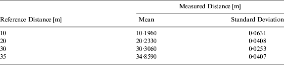
Ranging coverage and ranging accuracy tests were carried out. In this test, Cycle Error Rate (CER) is defined as connection failure rate occurring in a series of connections for P2P ranging and connection data sharing. Ten measurements were obtained on the each reference distance – 10 m, 20 m, 30 m and 35 m. In the case of reference distance more than 35 m, CER increases rapidly. Therefore, it is concluded in this test that ranging coverage of the CSS is 35 m.
The results of ranging accuracy tests in the coverage are summarised in Table 1. Also, this data is displayed in Figure 9 with curve fitting. The curve fitted equation is
 $$\tilde r = 0 {\cdot} 9912r + 0 {\cdot} 3570$$
where r and  $\tilde r$ mean reference distance and measured distance, respectively.
Curve fitting using the measurements obtained in the ranging accuracy test. (circles: measurements, ten measurements per distance).
Numerical results of ranging accuracy test (10 measurements per distance).
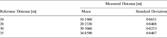
The results show that the measured distance in the outdoor environment using the CSS is so accurate in the coverage that ranging-based accurate localisation can be achieved.
A localisation accuracy test according to the baseline distance between the searching node and mobile node0 was carried out. Figure 10 shows the results of this test. Three nodes were installed at places with coordinate values of (0·0 m, 0·0 m) for the searching node, (σ m, 0·0 m) for the mobile node0, and (3·0 m, 20·0 m) for the mobile node1. σ means the baseline distance changed to 3·0 m, 6·0 m, 9·0 m and 12·0 m. 30 data sets were obtained at each baseline distance. Where triangles denote the true location of the mobile node1, spots denote estimated locations, and circles denote mean and standard deviation of estimation errors. As shown from the plots, the localisation accuracy is enhanced in proportion to the baseline distance; the reason is that the larger the baseline distance, the smaller the dilution of precision (DOP) value. However, it is difficult to place the mobile node0 far from the searching node. So, the location of the mobile node0 can be decided according to the surrounding environment of the searching node in the application area.
Localisation accuracy test according to baseline distance. (triangle: true location, spots: estimated 30 locations, error: root mean squared error (RMSE), SN: searching node, MN: mobile node).
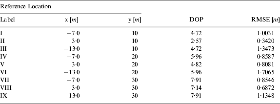
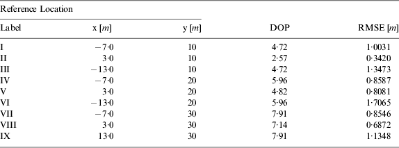
A localisation accuracy test of a mobile node according to relative locations of the mobile node and reference nodes was performed. Test results are shown in Figure 11 and Table 2. The mobile node0 was placed with baseline distance of 6·0 m. Nine reference locations were selected. At each reference location, 30 estimates were obtained. In Figure 11(a), triangles denote the true location of the target mobile node, and spots denote estimated locations. Also, DOP and root mean squared error (RMSE) of the estimated locations are denoted in Figure 11(b). As shown in the results, the RMSE of the estimated locations increases with distance between the searching node and target mobile node. Some RMSE values seem to be symmetrical: Locations 1 and 3, Locations 4 and 6, and Locations 7 and 9. The reason is that the estimation error trend is reflected on DOP decided based on the relative locations of the mobile node and reference nodes. Also, the accuracy on the y-axis is better than on the x-axis because the reference nodes are only on the x-axis. Therefore, we can state that the localisation accuracy is related to the relative locations of the mobile node to be localised at this step and reference nodes as well as the ranging accuracy, and base line distance.
Localisation accuracy test according to relative locations of a mobile node and reference nodes.
Numerical results of localisation accuracy test according to relative locations of a mobile node and reference nodes. (30 measurements at each reference locations of the mobile node and reference nodes)
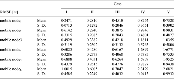
A number of localisation accuracy tests for multi-mobile nodes changing the mobile nodes' positions were carried out. In this test, six mobile nodes were used in light communication traffic. Five test cases were established and a series of algorithms were processed in each node under the five cases 30 times. Figure 12 shows the situations of the test cases and the test results and Table 3 denotes the numerical results of the test. As shown from the results, the arbitrary deployed mobile nodes can be localised accurately using the implemented system with the proposed P2P ranging procedure, connection data sharing procedure, and adaptive localisation algorithm. Also, it can be seen that the localisation accuracy is reliable even in the case of 2-hop localisation (Case V).
Localisation accuracy test for multi mobile nodes. (SN: searching node, MN: mobile node).
Numerical results of localisation accuracy test for multi mobile nodes. (30 measurements at each case)
Figure 13 shows a magnification of Figure 12(e) and connection data between the deployed mobile nodes and searching node. In this plot, dotted lines are direct connections between a conclusive reference node – one of the searching node and mobile node0 and a mobile node located in the coverage of the conclusive reference nodes. Dashed lines are secondary connections between a non-estimated mobile node and one of pre-determined reference nodes such as mobile node1, mobile node2 and mobile node3. Dash-dotted lines are tertiary conditions between a non-estimated mobile node and one of the secondary determined reference nodes such as mobile node4 and mobile node5. Estimation order and reference nodes are decided as follows: mobile node1 is localised using two reference nodes (searching node and mobile node0); mobile node2 is localised using three reference nodes (searching node, mobile node0 and mobile node1); mobile node3 is localised using four reference nodes (searching node, mobile node0, mobile node1 and mobile node2); mobile node4 is localised using three reference nodes (mobile node1, mobile node2 and mobile node3); mobile node5 is localised using four reference nodes (mobile node1, mobile node2, mobile node3 and mobile node4); and mobile node6 is localised using five reference nodes (mobile node1, mobile node2, mobile node3, mobile node4 and mobile node5).
Magnification of Figure 12(e) and connection data between nodes.
As shown in Figure 13 and Table 3, localisation errors increase with estimation order. Moreover, error trend of the estimated location is reflected on that of the reference nodes. That is, all of the estimates have errors biased to the left side. The reason is that the estimation error is caused by the location errors of the reference nodes, ranging errors and DOP. However, it can be concluded that the localisation performance of the proposed system containing the P2P ranging procedure, connection data sharing procedure and adaptive localisation algorithm is good for accurate localisation for a group of mobile nodes.
A mobility test of single mobile node was performed. Figure 14 and Table 4 show the test results. A pedestrian walked with a mobile node on the trajectory set previously at a rate of about 1 m a second. The proposed algorithms were processed periodically. The update time interval was set to 0·5 s. As shown in this figure, estimation accuracy is reliable. Also, the accuracy on the y-axis is excellent in comparison with the x-axis. Moreover, the moving path tracked in this test accurately corresponds with the true trajectory. Therefore, it can be stated that the proposed localisation system can also be used as a tracking system for a mobile node.
Mobility test of single mobile node.
Numerical results of mobility test of single mobile node.

It is remarkable that from a number of experimental tests, it can be found that a localisation service for a group of pedestrians such as soldiers in the particular area can be provided using the implemented localisation system with the proposed algorithms. A constraint condition of this system is the number of operating mobile nodes in an application area. In the operations of the P2P ranging procedure and connection data sharing procedure, communication congestion occurs because the CSS has only a single channel. To overcome this problem, it is necessary to secure additional high-speed channels using another PHY.
6. CONCLUSION
In this paper, two communication procedures and a localisation algorithm were established for a group of mobile nodes' localisation in anchor-free environments: a P2P ranging procedure, a connection data sharing procedure, and an adaptive localisation algorithm. The procedures and algorithm are designed such that they take into account features of a single channel CSS chipset on mobile wireless sensor networks in an attempt to localise a group of mobile nodes only with P2P ranging data among the nodes. Using the implemented nodes containing a CSS chipset, which is a state-of-the-art localisation sensor based on the standard of IEEE 802.15.4a, good localisation performance of the implemented localisation system containing the proposed methods (procedures and algorithm) was demonstrated with five tests. The author believes that the solutions in this paper are particularly beneficial in the territory of group navigation from a practical point of view, because they do not require any spatial and infrastructure constraints, or movement constraints on mobile nodes.