1. Introduction
The Zagros chain is among the most famous geological provinces in the world, renowned for its spectacular whaleback anticlines, extreme seismic activity and its textbook modern carbonate system, in addition to containing abundant oil and gas reserves. Many studies have covered the Zagros in terms of petroleum research (Ala, Kinghorn & Rahman, Reference Ala, Kinghorn and Rahman1980; Ala, Reference Ala1982; Bordenave & Burwood, Reference Bordenave and Burwood1990; Ghasemi-Nejad, Head & Naderi, Reference Ghasemi-Nejad, Head and Naderi2009), structural geology (Stocklin, 1968; Falcon, Reference Falcon and Spencer1974; Colman-Sadd, Reference Colman-Sadd1978; Bahroudi & Koyi, Reference Bahroudi and Koyi2003, Reference Bahroudi and Koyi2004; McQuarrie, Reference McQuarrie2004; Sherkati & Letouzey, Reference Sherkati and Letouzey2004; Sepehr & Cosgrove, Reference Sepehr and Cosgrove2004; Molinaro, Zeyen & Laurencin, Reference Molinaro, Zeyen and Laurencin2005; Lacombe et al. Reference Lacombe, Mouthereau, Kargar and Meyer2006, Reference Lacombe, Amrouch, Mouthereau and Dissez2007; Mouthereau et al. Reference Mouthereau, Tensi, Bellahsen, Lacombe, De Boisgrollier and Kargar2007; Aubourg et al. Reference Aubourg, Smith, Bakhtari, Guya and Eshtaghi2008; Jahani et al. Reference Jahani, Callot, Letouzey and Lamotte2009), basin evolution (Alavi, Reference Alavi2004, Reference Alavi2007) and carbonate stratigraphy (e.g. from the Oligo-Miocene Asmari limestone and older units, e.g. Szabo & Kheradpir, Reference Szabo and Kheradpir1978; Nadjafi et al. Reference Nadjafi, Mahboubi, Mossavi-Harami and Mirzaee2004; Vaziri-moghaddam, Kimiagari & Taheri, Reference Vaziri-moghaddam, Kimiagari and Taheri2006; Razin, Taati & van Buchem, Reference Razin, Taati, van Buchem, van Buchem, Gerdes and Esteban2010), while the younger mainly clastic Neogene deposits have received less investigation, at least until recently (Homke et al. Reference Homke, Verges, Garces, Emami and Karpuz2004; H. Emami, unpub. Ph.D. thesis, Univ. de Barcelona, 2008; Fakhari et al. Reference Fakhari, Axen, Horton, Hassanzadeh and Amini2008; Khadivi et al. Reference Khadivi, Mouthereau, Larrasoaña, Vergés, Lacombe, Khademi, Beamud, Melinte-Dobrinescu and Suc2010). This is probably because most petroleum is held within older units and because the younger sediments tend to be relatively homogeneous and more difficult to date and map as coherent units. This is unfortunate because the Neogene deposits form part of an exceptionally well-exposed foreland basin succession that records the evolving landscape along with local climate and tectonics in the region over the last 20 million years.
The purpose of this paper is to document in some detail the sediments composing the Neogene foreland basin in the Zagros, based largely on our own field investigation across the region over the last few years. In doing so, we aim to place the various deposits observed within the context of foreland basin depozones (see also Alavi, Reference Alavi2004, Reference Alavi2007), as already established for many other foreland basin systems (e.g. Sinclair et al. Reference Sinclair, Coakley, Allen and Watts1991; DeCelles et al. Reference DeCelles, Gehrels, Quade and Ojha1998; Mutti et al. Reference Mutti, Tinterri, Benevelli, Biase and Cavanna2003). The Zagros system offers an advantage over many other foreland basins in that it is currently active and has been so for a considerable time period. Thus, it provides an ideal case where one can investigate the transition in time and space between the modern-day palaeoenvironments (e.g. wedge-top, foredeep) and older deposits that were progressively buried and incorporated into the orogen as it widened through time. Our investigation shows a strong link between the various Neogene deposits and the modern depositional environments, which suggests that the previously described Neogene formations are likely to be strongly diachronous. Indeed, this is consistent with several recent studies that have shown that the age of the Agha Jari and Bakhtyari formations vary across the region (Homke et al. Reference Homke, Verges, Garces, Emami and Karpuz2004; H. Emami, unpub. Ph.D. thesis, Univ. de Barcelona, 2008; Fakhari et al. Reference Fakhari, Axen, Horton, Hassanzadeh and Amini2008; Khadivi et al. Reference Khadivi, Mouthereau, Larrasoaña, Vergés, Lacombe, Khademi, Beamud, Melinte-Dobrinescu and Suc2010; see also Saura et al. Reference Saura, Vergés, Homke, Blanc, Serra-Kiel, Bernaola, Casciello, Fernández, Romaire, Casini, Embry, Sharp and Hunt2011).
2. Geological setting
The Zagros is a mountain belt that extends more than 2000 km between the Hormuz strait and NW Iran. The tectonic history of the Zagros can be divided into four main stages (e.g. Stöcklin, Reference Stöcklin1968, Reference Stöcklin, Burk and Drake1974, Reference Stöcklin1977; Adamia et al. Reference Adamia, Chkhotua, Kekelia, Lordkipanidze and Shavishvili1981; Berberian & King, Reference Berberian and King1981; Koop & Stoneley, Reference Koop and Stoneley1982; Sengor, Reference Sengor, Robertson, Searle and Ries1990; Beydoun, Reference Beydoun1991; Beydoun, Clarke & Stoneley, Reference Beydoun, Clarke, Stoneley, Macqueen and Leckie1992; Sepehr & Cosgrove, Reference Sepehr and Cosgrove2004):
(1) Early Palaeozoic stable passive margin. During this period the region was part of a stable passive margin of Gondwana bordering the Palaeo-Tethys ocean to the north (Berberian & King, Reference Berberian and King1981). The oldest well-known sediment deposited during this stage is the Lower Cambrian Hormuz salt (R. A. Player, unpub. Ph.D. thesis, Univ. Reading, 1969; Kent, Reference Kent1970), which occurs mainly east of the Kazerun fault zone, where it can attain a thickness of 2000 m (Falcon, Reference Falcon and Spencer1974; Beydoun, Clarke & Stoneley, Reference Beydoun, Clarke, Stoneley, Macqueen and Leckie1992; Talbot & Alavi, Reference Talbot, Alavi, Alsop, Blundell and Davison1996; Sepehr & Cosgrove, Reference Sepehr and Cosgrove2005).
(2) Permo-Triassic rifting. Extension during this time led to opening of the Neo-Tethys ocean separating the Iranian microplate to the north from the Arabian plate to the south. At the same time the Palaeo-Tethys basin to the north was closed. During this period a considerable amount of sediments, dominated by carbonate and volcanic rocks, were deposited and many NW–SE-trending normal faults were active.
(3) Jurassic passive continental margin. During this time a passive margin continued to develop on the northern part of the Arabian plate. However, the characteristics of this margin vary considerably in an E–W direction, with major changes coinciding with N–S structures such as the Kazerun and Izeh fault zones. To the east, in the Fars region where the margin was relatively elevated, mainly shallow marine carbonates and marls were deposited. In the Lorestan region further to the west, the margin was deeper and contains deep water sediments (Setudehnia, Reference Setudehnia1978; Sepehr & Cosgrove, Reference Sepehr and Cosgrove2004).
(4) Cretaceous–Recent subduction and collision. Subduction of the Neo-Tethys ocean during Cretaceous time (which possibly initiated even earlier) eventually led to continent–continent collision between the Arabian and Iranian plates, which began some time in the middle Tertiary, though the exact timing is still debated (e.g. see Agard et al. Reference Agard, Omrani, Jolivet and Mouthereau2005; Mouthereau et al. Reference Mouthereau, Tensi, Bellahsen, Lacombe, De Boisgrollier and Kargar2007; Allen & Armstrong, Reference Allen and Armstrong2008; Ballato et al. Reference Ballato, Uba, Landgraf, Strecker, Sudo, Stockli, Friedrich and Tabatabaei2011). Collision led to deformation, uplift and erosion of the Arabian passive margin sequence in the Zagros Mountains, while towards the south a foreland basin was formed. The Zagros Mountains and the foreland are currently seismically extremely active. Recent GPS measurements indicate that the Arabian plate continues to move northwards relative to the Iranian microplate at rates of 20 ± 5 mm yr−1 (Tatar et al. Reference Tatar, Hatzfeld, Martinod, Walpersdolf, Ghafori-Ashtiany and Chery2002; Blanc et al. Reference Blanc, Allen, Inger and Hassani2003; Nilforoushan et al. Reference Nilforoushan, Masson, Vernant, Vigny, Martinod, Abbassi, Nankali, Hatzfeld, Bayer, Tavakoli, Ashtiani, Doerflinger, Daignieres, Collard and Chery2003; Allen, Jackson & Walker, Reference Allen, Jackson and Walker2004; Allen et al. Reference Allen, Blanc, Walker, Jackson, Talebian and Ghassemi2006; Vernant et al. Reference Vernant, Nilforoushan, Hatzfeld, Abbassi, Vigny, Masson, Nankali, Martinod, Ashtiani, Bayer, Tavakoli and Chéry2004; Rielinger et al. 2006; Walpersdorf et al. Reference Walpersdorf, Hatzfeld, Nankali, Tavakoli, Nilforoushan, Tatar, Vernant, Chéry and Masson2006).
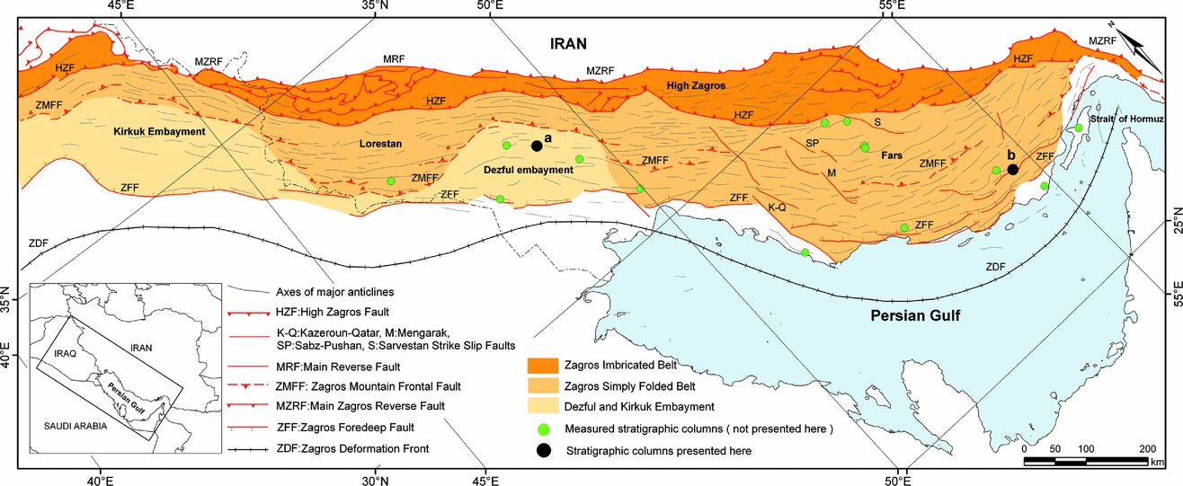
At the present day, the Zagros region can be divided into three main tectonic units. From north to south they are the Urumieh–Dokhtar volcanic belt, the Sanandaj–Sirjan metamorphic belt and the Zagros fold–thrust belt. The latter two units are separated by the Main Zagros Reverse Fault. The Zagros fold–thrust belt can itself be divided into two main zones, the High Zagros Imbricated Zone to the north and the Zagros Simply Folded Belt, separated by the High Zagros Fault. The Zagros Mountain Frontal Fault separates the Simply Folded Belt from the Dezful Embayment, while the Zagros Foredeep Fault separates the Dezful Embayment from the undeformed foreland to the south (Fig. 1). In addition to these tectonic subdivisions, the Zagros region can be separated into three main geological provinces. From west to east, these are the Lorestan, Khuzestan (Izeh Zone and Dezful Embayment) and Fars provinces. The boundaries between these provinces coincide with major N–S faults that were formed before collision (Bahroudi & Talbot, Reference Bahroudi and Talbot2003).
Structural setting and tectonic subdivisions of the Zagros fold–thrust belt and foreland basin of southwestern Iran and Northern Iraq (after Berberian, 1995). Also indicated are the positions of several major faults and the locations of the stratigraphic columns (indicated with black dots labelled a and b) shown in Figure 6.

3. Modern Zagros foreland basin
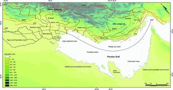
We begin our study by summarizing the main features of the foreland basin as observed today in the Zagros. Investigating the modern system is important because it provides a key to understanding the ancient deposits. The modern foreland basin can be broadly subdivided into wedge-top and foredeep following the classification scheme of DeCelles & Giles (Reference DeCelles and Giles1996). No forebulge is clearly distinguishable on the basis of present-day topography. The boundary between wedge-top and foredeep coincides with the current deformation front, which occurs somewhere near the northern coastline of the Persian Gulf before continuing northwestward into terrestrial Iraq (Fig. 2).
Zagros foreland basin divisions and modern sedimentary environments. MZRF – Main Zagros Reverse Fault; HZF – High Zagros Fault; ZMFF – Zagros Mountain Frontal Fault; ZFF – Zagros Foredeep Fault; and ZDF – Zagros Deformation Front.

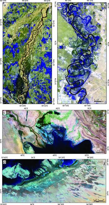
In the eastern part of the Zagros within the Fars region, the wedge-top consists of a series of sub-parallel, roughly E–W-trending anticlines and synclines with wavelengths of 20–40 km and topographic relief of approximately 1500 m (Mouthereau, Lacombe & Meyer, Reference Mouthereau, Lacombe and Meyer2006; Mouthereau et al. Reference Mouthereau, Tensi, Bellahsen, Lacombe, De Boisgrollier and Kargar2007). Major rivers in this region are rare (but include the Mand, Heleh and Kal rivers) and are ephemeral (Fig. 2). They wind their way across the fold belt, avoiding most major structures by passing around the noses of plunging anticlines before eventually reaching the Persian Gulf in the south. In the western part of the Iranian Zagros within the Dezful Embayment, the wedge-top can be divided into two main regions. North of the Zagros Mountain Frontal Fault, the wedge-top consists of mainly mountainous terrane reaching elevations of close to 3000 m. This region mainly undergoes erosion but local deposition does occur along some major river valleys which cut transversely to the NW–SE-trending structures. These rivers are either braided (Fig. 3a) or cut directly into bedrock along deep river gorges. South of the Zagros Mountain Frontal Fault the mountainous topography gives way to an extensive, low relief, depositional flood plain broken only occasionally by linear ridges associated with growing anticlines. In this region, the rivers that exit the mountains to the north eventually become meandering (Fig. 3b) before reaching the northwestern corner of the Persian Gulf (Fig. 3c). The major river systems draining this part of the wedge-top basin are the Karkheh and Karun rivers and contain water all year round (Fig. 2).
Satellite images of different modern sedimentary environments in the Zagros foreland basin. (a) Braided river system in the northern Dezful area. (b) Meandering river system in the southern part of the Dezful Embayment. (c) Coastal plain and shallow marine environments where several major meandering rivers enter the northwestern corner of the Persian Gulf. (d) The southern coast of the Persian Gulf east of the Qatar Peninsula showing supratidal and sabkha environments in light blue (mid grey). Note also sand dunes related to the Shamal wind.

The foredeep of the Zagros foreland basin is marine where it coincides with the Persian Gulf, while it is non-marine in Iraq and the southwestern corner of Iran. The terrestrial part of the foredeep consists of an extensive, low relief flood plain occupied by several major meandering rivers (such as the Tigris and Euphrates rivers) that flow mainly axially along the foredeep, parallel to the deformation front, before eventually entering into the Persian Gulf (Fig. 2). The Persian Gulf itself is a major semi-closed basin approximately 1000 km long and 85 to 350 km wide. The Persian Gulf lacks major wave swell and has small tides. The median water depth is 35 m and a maximum depth of 100 m occurs in the Strait of Hormuz (Emery, Reference Emery1956; Purser & Seibold, Reference Purser, Seibold and Purser1973). The northern part of the Persian Gulf includes a belt affected by Plio-Pleistocene Zagros folding, faulting and salt diapirism, and thus is part of the wedge-top, whereas only the southern portion can be considered proper foredeep. The northern shoreline is mostly rocky and linear with estuaries and flood plains that are associated with rivers draining the Zagros fold belt to the north. The southern shoreline is mostly linear but is broken by the Qatar Peninsula, which has an important role in the sedimentary environment on either side (Purser & Seibold, Reference Purser, Seibold and Purser1973). Towards the east of the peninsula occurs one of the classic modern-day carbonate–evaporite systems of the world. From south to north it includes lagoon, restricted shelf, open shelf, ramp and basin (Fig. 2). The coast of the United Arab Emirates is a shallow (< 20 m), high-energy environment where clastic input is low and bioclastic and oolitic sands dominate (Purser & Seibold, Reference Purser, Seibold and Purser1973). The deeper parts of the Persian Gulf to the north have a low to moderate energy where fine-grained argillaceous and micritic sands accumulate (Houbolt, Reference Houbolt1957; Purser & Seibold, Reference Purser, Seibold and Purser1973). On the western side of the Qatar Peninsula, the basin has a high aeolian sediment supply (owing to the Shamal wind), which is reworked by tidal currents in a shallow marine environment. The aeolian terrigenous sediments consist of fine sand to clay with high contents of carbonate particles (Foda, Khaiaf & Al-kadi, Reference Foda, Khaiaf and Al-Kadi1985). The northwestern corner of the Persian Gulf has a high clastic sediment input owing to the presence of major river systems draining the Zagros mountain belt to the north (Figs 2, 3c). In some places on the southern coast of the Persian Gulf, quartzite dunes are presently entering the Persian Gulf (Fryberger, Al-Sari & Clisham, Reference Fryberger, Al-Sari and Clisham1983).
4. Neogene foreland basin deposits
In this Section we provide a detailed description of the sedimentary deposits that compose the Neogene foreland basin. This Section is based mainly upon our own studies during which we have measured a total of 16 stratigraphic columns (see Fig. 1) at metre-scale resolution, amounting to a total stratigraphic thickness of approximately 35 km. Two of these stratigraphic columns, one located in the Dezful province and the other in the Fars region, are presented in Figure 6. Our description begins with the Gachsaran Formation, which is the first deposit after the Asmari limestone that provides evidence for significant clastic input related to collision. In the following Section we largely sidestep the issue of time, placing greater emphasis on depositional facies (Reading, Reference Reading1986, pp. 20–342; Reineck & Singh, Reference Reineck and Singh1980, pp. 257–456). The reason for this is partly because we currently do not have good time constraints and partly because, based on our field study, we suspect that the Neogene formations’ boundaries must be diachronous (as shown recently by Homke et al. Reference Homke, Verges, Garces, Emami and Karpuz2004; H. Emami, unpub. Ph.D. thesis, Univ. de Barcelona, 2008; Fakhari et al. Reference Fakhari, Axen, Horton, Hassanzadeh and Amini2008; Khadivi et al. Reference Khadivi, Mouthereau, Larrasoaña, Vergés, Lacombe, Khademi, Beamud, Melinte-Dobrinescu and Suc2010). This point will be elaborated upon in greater detail in Section 5.
4.a. Gachsaran Formation
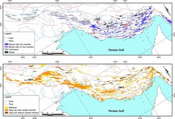
The Gachsaran Formation is one of the most important formations in the Zagros foreland basin. On the one hand, it acts as a cap rock for the Asmari Formation petroleum reservoir and on the other hand, it forms a detachment level above which the overlying formations can be decoupled from deeper structures. Different sedimentary facies and sudden changes in the thickness have added to its complexity (O'Brien, Reference O'Brien1957; Dunnington, Reference Dunnington1968; Stocklin, 1968; Bahroudi & Koyi, Reference Bahroudi and Koyi2004). This formation extends across the whole of the Zagros foreland basin (Fig. 4a) and consists of three main lithofacies associations in the 16 sections studied.
Maps showing the distribution of major Neogene formations in the Zagros foreland basin based on published geological maps. (a) Distribution of the Razak, Gachsaran, Guri Member and Mishan units. (b) Distribution of the Agha Jari and Bakhtyari units. K-Q – Kazeroun-Qatar fault; M – Mengarak fault; ZMFF – Zagros Mountain Frontal Fault.

4.a.1. GS1
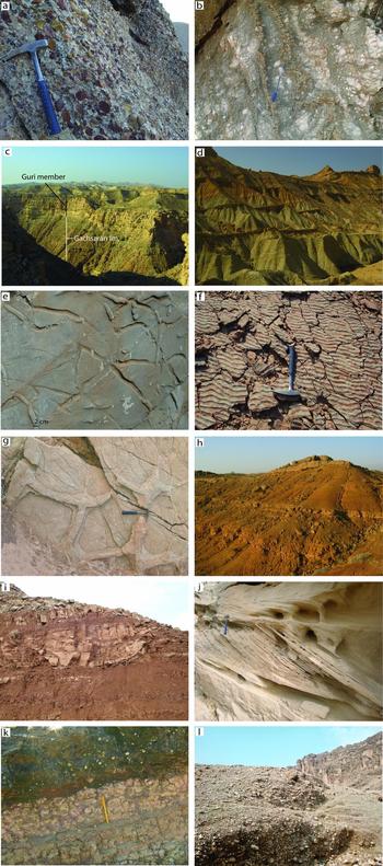
This lithofacies association consists of a basal conglomerate bed overlain by red mudstones along with siltstone interbeds, sandstone bodies and bioclastic limestones. The basal conglomerate is massive to faintly bedded, grain supported, well cemented and includes in situ marine fossils (Fig. 5a). The clasts of the conglomerate have a high sphericity, are medium sized (3–8 cm), well sorted and well rounded. Lenticular sandstones exhibit cross-bedding and are less than 2 m thick. This lithofacies association is known as the Razak Formation in the High Zagros region and the interior Fars area (Fig. 4a). The general thickness of this formation decreases towards the south away from the Zagros mountain belt where it may be tens of metres to 750 m thick.
Field photos of the Neogene foreland basin sediments in the Zagros. (a) Basal conglomerate of the Razak Formation (lower part of lithofacies association GS1). (b) Gypsum and evaporate layers of the Gachsaran Formation (GS3). (c) Massive limestone of the Guri Member overlying the Gachsaran Formation (MN2). (d) Easily erodible green marls of the Mishan Formation (MN3). (e) Horizontal bioturbation in a sandstone bed in the lower part of the Agha Jari Formation (AJ1). (f) Wave ripple marks in a mottled sandstone interbed (AJ1). (g) Mud cracks in the Agha Jari Formation (AJ1). (h) Repetition of sheet-like sandstone bodies and red flood plain silty-marls (AJ2). (i) Lenticular channel type sandstone body enclosed within red silty-mudstones (AJ2). (j) Cross-bedded sandstone in the Agha Jari Formation (AJ2). (k) Palaeosoil horizon with calcite nodules overlain by a sandstone channel (AJ2). (l) Massive gravel conglomerate of the Bakhtyari Formation (BK1a). Length of rock hammer is 33 cm and pen is 15 cm.

4.a.2. GS2
This unit, which crops out mainly in the coastal Fars and northern part of Persian Gulf, consists of about 250 m of carbonate rocks, green marls, mudstones and evaporite deposits. This unit can be subdivided into three main sub-facies (GS2a–c). The GS2a sub-lithofacies association includes gypsum, anhydrite, red and green marl and marly limestone interbeds, and is widely known as the Chehel Member. This sub-unit contains abundant brachiopods, miliolids, globigerinids and Peneroplis evolutus. The next sub-unit (GS2b), known as the Champeh Member, consists of almost 120 m of fossiliferous limestones, dolomite and resistant green marls that exhibit sharp morphologies in outcrop. This sub-unit contains Peneroplis farsensis, Miogypsina sp., Dendritina rangi, rotalids and bryozoans. The next sub-lithofacies association (GS2c), known as the Mol Member, includes approximately 60 m of easily erodible red, grey and green mudstones and also evaporitic sediments. This sub-lithofacies association contains Miogypsina sp., Peneroplis farsensis, Taberina sp., rotalids and bryozoans (James & Wynd, Reference James and Wynd1965).
4.a.3. GS3
The last major lithofacies association of the Gachsaran Formation includes abundant gypsum, salt, anhydrite and also coloured marls (Fig. 5b). This unit is extensive in the southern part of the Persian Gulf and western part of the Zagros foreland basin where it may attain a thickness of 1500 m. This sub-lithofacies association is dominated by salt layers in the extreme eastern part of the Zagros (Strait of Hormuz) where it is called the Qeshm Formation. This lithofacies association is commonly highly deformed owing to its ductile nature related to abundant evaporites.
4.a.4. Interpretation
The Razak Formation (GS1) is a synorogenic deposit that was most likely produced by a fluvial system, probably braided rivers, in a coastal plain environment. This clastic lithofacies association (GS1) is replaced by an open shallow marine carbonate system (GS2) in the eastern part of the Zagros foreland basin in the Fars area. Also, this clastic system (GS1) is replaced by supratidal and sabkha depositional environments (GS3) in the western and extreme eastern parts of the Zagros foreland basin (Dezful and Bandar Abbas regions, respectively) and the southern part of the Persian Gulf (Fig. 4a).
4.b. Mishan Formation
The Mishan Formation consists of easily erodible green and grey marls with thin ridge-forming carbonates, oyster beds and shelly detrital limestones. It becomes conglomeratic near the top in some places. This formation also includes a massive limestone bed, occasionally with thin green marl interbeds, close to the bottom, which is commonly called the Guri Member. The Guri Member does not exist in the western part of the Zagros foreland basin (Fig. 4a). It is thin in the eastern part of Dezful area (tens of metres) and increases in thickness towards the ESE where it may reach a thickness of 1600 m in the Bandar Abbas area. Three main lithofacies associations can be identified (MN1–3).
4.b.1. MN1
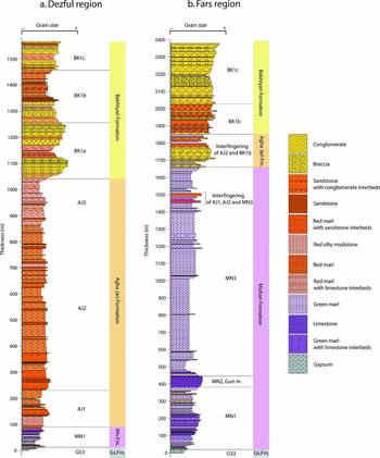
The lower lithofacies association consists of evaporite deposits, red mudstones, sandy-limestones, limestones and green marls. In its upper part, this unit is mostly dominated by green marl and coquina limestone interbeds containing bryozoans, ostracods and foraminifera. The foraminifera are essentially small benthic species with some larger Miogypsina spp. The benthic foraminifera include Miogypsina globulina, anomalinids, textulariids, rotalids, asterigerinids and Clavulina sp. Planktonic foraminifera are extremely rare but consist of Globigerinoides trilobus, G. bisphericus, G. sacculifer, G. immaturus, G. quadrilobatus, G. parawoodi, Globigerinoides spp., Globoquadrina cf. praedehiscens, Catapsydrax martini, Globoturborotalia woodi, Globigerina cf. praebulloides, G. cf. eamesi and Globigerina spp. The thickness of this unit is variable from several metres to 400 m, increasing towards the southeast (Fig. 6a, b).
Measured stratigraphic columns through the post-Asmari Neogene formations in the Dezful (a) and Fars (b) regions (only the upper part of the Gachsaran is shown). Also shown are major lithofacies associations as discussed in the main text. The location of these stratigraphic profiles is shown on Figure 1.

4.b.2. MN2
The next lithofacies association, commonly known as the Guri Member, consists of massive to thick-bedded, brownly weathered, biosparite and biomicrite limestones that occur mainly in the Fars area where it may reach a thickness of up to 1200 m (Fig. 5c). This unit consists of abundant benthic foraminifera and coral. The identified microfauna include Operculina complanata, Nephrolepidina sp., Miogypsina sp., Flosculinella bontangensis, Dendritina cf. rangi, Taberina malabarica and Neoalveolina (Borelis) melo (James & Wynd, Reference James and Wynd1965). This unit also contains planktonic foraminifera, including Globigerinoides triloba, G. sacculifera, G. cf. rubra and Orbulina universa (James & Wynd, Reference James and Wynd1965). The MN2 lithofacies association is reefal in many places in the eastern Fars, whereas in the west it occurs as interbedded resistant limestone separated by thin green marls. This unit makes a salient morphology in the Fars area (Fig. 6b).
4.b.3. MN3
The last lithofacies association tends to be dominated by thick-bedded to massive green marls with occasional thin limestone interbeds (< 2 m) and thin oyster beds (< 0.5 m) (Fig. 5d). The thickness of this unit increases towards the SSE in the Fars area where it can be up to 700 m thick (Fig. 6b).
4.b.4. Interpretation
The Mishan Formation is interpreted to be deposited in a shallow marine environment within a generally upward-deepening (transgressive) trend. The MN1 lithofacies association probably represents a lagoon or similar restricted environment, which was sometimes replaced by supratidal and sabkha environments. The next lithofacies association (MN2) containing the Guri Member reefal limestone is interpreted to be deposited in a low-energy shallow carbonate system that deepened towards the north. The MN3 lithofacies association dominated by fine-grained marls is interpreted to be the deeper open marine part of the carbonate system.
4.c. Agha Jari Formation
The Agha Jari Formation consists of repetitively interbedded resistant sandstone beds separated by easily erodible mudstones. The proportion of mud-rich to sand-rich units is typically approximately 75%/25%. This formation is the thickest formation in the Zagros foreland basin (James & Wynd, Reference James and Wynd1965; Setudehnia, Reference Setudehnia1972; Favre, Reference Favre1974; Motiei, Reference Motiei1993).The thickest part is usually situated along the axis of synclines and in front of major thrusts. The overall thickness of the formation decreases towards the southeast away from Zagros Mountains where it may be more than 3000 m thick (Fig. 4b). Three main lithofacies associations can be identified (AJ1–3).
4.c.1. AJ1
In the lower part of the Agha Jari Formation, sandstone units tend to be thin (< 1 m), parallel laminated and laterally extensive over hundreds of metres. These units display abundant (both horizontal and vertical) bioturbation (Fig. 5e), along with ripple marks (Fig. 5f), mud cracks (Fig. 5g), load casts, unidirectional flute casts and oxidized plant fragments. Flaser bedding and small (centimetre)-scale climbing ripples are also sometimes observed, both of which contain mud drapes. The sandstones are fine-grained, well-sorted litharenites containing sub-rounded grains with low sphericity. Lithic fragments consist mainly of carbonate clasts and occasional shell fragments derived from older carbonate units. The sandstones do not contain any ‘in place’ fossils except in the more proximal part of the basin where the Agha Jari Formation overlies the Razak Formation (Khadivi et al. Reference Khadivi, Mouthereau, Larrasoaña, Vergés, Lacombe, Khademi, Beamud, Melinte-Dobrinescu and Suc2010). The sandstones are separated along sharp parallel contacts with reddish-grey coloured mudstones with thicknesses of less than 10 m (and more typically 1 m thick). The entire thickness of this part of the formation does not exceed approximately 300 m.
4.c.2. AJ2
Higher in the Agha Jari Formation, the sandstones are thicker (up to 30 m) and vary between sheet-like (Fig. 5h) and lenticular (Fig. 5i). The lenticular bodies extend laterally over distances of tens to hundreds of metres whereas the sheets may continue for several kilometres (Fig. 5h). The sandy units display impressive (mostly unidirectional) cross-stratification at a scale from 30 cm to several metres, with foreset angles ranging from 10° to 45° (Fig. 5j). These units themselves are not bioturbated, though directly adjacent thin sandstone beds may rarely show bioturbation. The sandstones are well-sorted, mature calcareous litharenites. These sandstones are separated by thick (5–100 m) units of red silty-mudstone (Fig. 5h, i) displaying mottled textures, mud cracks and calcite nodules (Fig. 5k).
4.c.3. AJ3
The upper part of the Agha Jari Formation is separated into the Lahbari Member in front of the Zagros Mountain Frontal Fault, which consists of about 1600 m of siltstone, silty mudstone and cross-bedded, lenticular sandstone bodies (Figs 4b, 6a). The Lahbari Member is typically light coloured, poorly indurated and highly porous, and it consists of poorly sorted, low maturity sandstone with low sphericity and sub-angular grains.
4.c.4. Interpretation
The Agha Jari Formation is a synorogenic deposit produced by erosion of the uplifting Zagros mountain belt during collision. The lower part of the Agha Jari Formation (AJ1) is interpreted to be deposited on a low relief, low energy, tidal flat or estuarine environment probably influenced by both fluvial and marine processes. Similar deposits have been summarized by Reineck & Singh (Reference Reineck and Singh1980, pp. 315–20). In the more distal part of the foreland basin, the Agha Jari Formation is likely to be more fully marine, as indicated by the more common occurrence of homogeneous grey silty marls, possibly deposited in a delta or pro-delta setting. The second lithofacies association of the Agha Jari Formation (AJ2) is interpreted to be formed by a laterally migrating, high sinuosity (probably meandering) sandy river system developing on a flat extensive foreland plain. Sandstone bodies are interpreted to represent point bars, channels and levée deposits, whereas the red coloured silty mudstones are interpreted as adjacent flood pain deposits, which is also consistent with the presence of interpreted palaeosoil horizons. Note that this lithofacies has a broadly bimodal grain-size distribution, with sand (e.g. in channels) and silt-mud (in floodplains). In comparison to the AJ1 and AJ2, the Lahbari Member (AJ3) is interpreted to represent a lower sinuosity, more laterally confined river system depositing during a period of relatively high generation of accommodation space. This member does not exist in the internal part of the wedge-top basin.
4.d. Bakhtyari Formation
The Bakhtyari Formation is traditionally considered to be the youngest synorogenic deposit of the Zagros foreland basin (Fakhari et al. Reference Fakhari, Axen, Horton, Hassanzadeh and Amini2008). It consists mainly of massive conglomerates along with cross-bedded gravels, sandstones and mudstones (Figs 4b, 6a, b). The general thickness of the formation decreases towards the south away from Zagros Mountains where it may be several metres to 2400 m thick. Clasts in the Bakhtyari conglomerates are mostly derived from formations that are exposed in nearby anticlines and salt diapir structures. The transition from the Agha Jari Formation to the Bakhtyari Formation can be either an angular unconformity, a paraconformity or continuous (i.e. gradational). Within the Bakhtyari Formation two main lithofacies associations can be identified in the Zagros foreland basin (BK1–2).
4.d.1. BK1
This lithofacies association consists of large amounts of gravels and can be regarded as the typical deposits by which the Bakhtyari Formation is known. Its thickness and make-up are extremely variable from place to place. This lithofacies association can be further divided into three sub-lithofacies associations (BK1a–c).
4.d.1.a. BK1a
This sub-lithofacies association of the Bakhtyari Formation consists of massive to faintly bedded (on a scale from 3 m to tens of metres), coarse-grained (mostly 10–50 cm and sometimes over 1 m), clast-supported, well-cemented, polymictic conglomerates (Fig. 5l). It contains well-rounded clasts with medium sphericity and shows poor to medium sorting. Most clasts are Cretaceous and Jurassic carbonates, igneous rocks derived from the suture zone and plutonic rocks of the Sanandaj–Sirjan zone in the High Zagros. It also consists of chert clasts which are recycled from the Razak Formation in the Interior Fars and carbonates and radiolarian cherts from the Amiran and Kashkan formations in the Dezful area (Fig. 6a).
4.d.1.b. BK1b
This sub-lithofacies association of the Bakhtyari Formation consists of repeated upward-coarsening sandstones and conglomerate beds in a brownish red silty mudstone and siltstone. The thickness of conglomerate and sandstone beds is 2 to 6 m whereas the thickness of silty mudstones is 12 to 20 m. These bodies tend to be lenticular and extend laterally for several hundred metres. The size of boulders is several centimetres to 20 cm and sometimes over 50 cm. The sandstones are coarse grained, medium cemented, immature, poorly sorted and exhibit cross-bedding and numerous erosional surfaces. The conglomerate bodies display cross-bedding, graded bedding and clast imbrications. This sub-lithofacies association is especially well represented in the eastern part of the Dezful area where it is normally observed above BK1a (Fig. 6a, b).
4.d.1.c. BK1c
This sub-lithofacies association consists of matrix- or clast-supported, very poorly sorted, poorly cemented conglomerate or breccia containing sub-angular, low sphericity boulders (10 cm to several metres in diameter) embedded within a brownish muddy silty matrix. This sub-unit consists of clasts that are mostly locally derived. This unit is only locally represented where it tends to be near the top of the Bakhtyari Formation. Its maximum thickness is in the order of 100 m (Fig. 6a, b).
4.d.2. BK2
This lithofacies association, which is observed only in the High Zagros (Fakhari et al. Reference Fakhari, Axen, Horton, Hassanzadeh and Amini2008) and was not observed in our sections, consists of limestone, grey marl and occasionally sandstone which can attain a thickness of 40 m. The limestones and marls consist of in situ corals, Miogypsinoides complanatus, Miogypsinoides sp., Subterraniphyllum thomasi, Lithophyllum sp. and Ammonia beccarii, which indicate an Early Miocene age (Elliott, Reference Elliott1957; Fakhari et al. Reference Fakhari, Axen, Horton, Hassanzadeh and Amini2008). This lithofacies association also includes pollen, spores and dinoflagellate cysts comprising Slowakipollenites sp., Periporopollenites sp., Monoporopollenites sp., Compositae-type pollen, Saxosporis sp., Verucatosporites sp., Homotrydium oceanicum, Hystrichokolpoma rigaudiae, Spiniferites mirabilis, Cleistosphaeridium placacanthum, Fibrocysta sp. and Deflandrea sp. (Fakhari et al. Reference Fakhari, Axen, Horton, Hassanzadeh and Amini2008).
4.d.3. Interpretation
The ‘typical’ Bakhtyari Formation is interpreted to be a fluvial syntectonic wedge-top basin deposit. The BK1a sub-lithofacies association is interpreted to be deposited by a very low sinuosity (probably braided) fluvial system on a wide, low relief, gravel-dominated flood plain. These extensive sheet-like deposits were probably formed by the amalgamation of smaller fans related to individual river systems draining the Zagros Mountains. The BK1b sub-lithofacies association occurs above BK1a and differs from BK1a in that it is finer grained and shows distinctly different channel versus flood plain deposits. The BK1b association most likely represents a retrograding system where the finer grained, higher sinuosity river systems of the foreland stepped backwards towards the mountain front, replacing the previously deposited braided river deposits. The cause for such a retrogression is unknown but could for example be linked to a relative base level rise. The last fan-shaped sub-lithofacies association (BK1c) is interpreted to be deposited on an alluvial fan by intermittent mass flows within an overall braided river system. The second major lithofacies association (BK2) is interpreted to be a marine deposit and represents a transgressive system related probably to a relative base level rise in the Zagros area during Early Miocene time. BK1b is overlain by BK1a or locally by BK1c, which indicates a return to the ‘normal’ foreland-advancing prograding braided river system. It is important to bear in mind that in the High Zagros this deposit is significantly older than typical Bakhtyari deposits exposed in more external parts of the Zagros foreland basin (Fakhari et al. Reference Fakhari, Axen, Horton, Hassanzadeh and Amini2008; Khadivi et al. Reference Khadivi, Mouthereau, Larrasoaña, Vergés, Lacombe, Khademi, Beamud, Melinte-Dobrinescu and Suc2010).
5. Discussion
The Neogene foreland basin sediments investigated as part of our study display a broadly coarsening-upward, regressive mega-cycle that presumably records the progressive uplift and southward migration of the Zagros mountain belt through time, as has been recognized by numerous other authors (e.g. Alavi, Reference Alavi2004, Reference Alavi2007; Fakhari et al. Reference Fakhari, Axen, Horton, Hassanzadeh and Amini2008; Heydari, Reference Heydari2008; Khadivi et al. Reference Khadivi, Mouthereau, Larrasoaña, Vergés, Lacombe, Khademi, Beamud, Melinte-Dobrinescu and Suc2010). This succession passes upwards from shallow marine supratidal and sabkha deposits at the base (Gachsaran Formation), into reefal carbonates (Guri Member present mainly in the eastern Zagros) and shallow marine marls (Mishan Formation) into marginal marine estuarine or tidal flat sediments (basal part of Agha Jari Formation) and finally into sand- and then gravel-dominated fluvial deposits at the top (middle–upper Agha Jari and Bakhtyari formations).
As for many other peripheral foreland basin systems (e.g. Sinclair et al. Reference Sinclair, Coakley, Allen and Watts1991; DeCelles et al. Reference DeCelles, Gehrels, Quade and Ojha1998; Mutti et al. Reference Mutti, Tinterri, Benevelli, Biase and Cavanna2003), this succession can be interpreted in terms of migrating depozones (see also Alavi, Reference Alavi2004 for the Zagros). In the Zagros, the wedge-top depozone is represented mainly by the Agha Jari and Bakhtyari formations, though in the Fars region, part of the Mishan also occupies a wedge-top position. The Zagros foredeep is represented mainly by the marine Mishan Formation, except towards the northwest (i.e. southwestern Iran and Iraq) where the Agha Jari Formation can be found in a foredeep position. The Gachsaran Formation is probably deposited in either a distal foredeep or proximal forebulge position.
It is important to emphasize that the lithofacies associations identified in the previous Section are not restricted to occurring within specific formations. For example, it is common to observe inter-fingering of the BK1b and AJ2 associations (Fig. 6b), which we interpret to indicate repeated oscillation of the braided to meandering transition through time. Although this observation makes sense in terms of depositional environments, it is problematic in terms of formation boundaries, since they are often transitional and difficult to define at an outcrop scale.
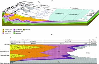
Our investigation highlights a close link between the main Neogene foreland basin deposits and the modern sedimentary environments (Fig. 7a). For example, the Bakhtyari Formation consists of mainly gravel sheets, which are interpreted to represent braided river deposits. The modern braided rivers (Fig. 3a) which are active in the Zagros foreland basin are modern analogues of the Bakhtyari Formation. Not only do the palaeoenvironments of the Bakhtyari Formation correspond to the modern braided river systems but the spatial distribution of modern braided river deposits matches the outcrops of the Bakhtyari Formation. In the downstream direction, these modern braided rivers become meandering systems (Fig. 3b), which can be considered equivalents of the Agha Jari palaeoenvironment. The modern meandering system includes sand bars and sandy channel deposits within muddy flood plain deposits, which would correspond with the cross-bedded sandstone bodies and red mudstones of the Agha Jari Formation. These deposits are particularly thick in the Dezful area owing to a combination of high sediment input related to several large rivers, along with high subsidence linked with major crustal thickening in the adjacent Zagros Mountains. In comparison, these deposits are relatively thin in the Fars region where sediment supply and total subsidence are lower and the wedge-top contains a greater proportion of marine sediments. In foreland basin terminology, this region can be considered as ‘under filled’. Eventually, the meandering rivers meet the Persian Gulf leading to the deposition of fine-grained argillaceous and micritic sandy sediments along its low–moderate energy northern portion. This is the site of the ‘modern-day’ Mishan shallow marine marls. Along the southeastern portion of the Persian Gulf is a high-energy, low water depth (< 20 m) carbonate ramp dominated by bioclastic and oolitic sands and reefs, representing the ‘Guri Member palaeoenvironment’. In the modern marine foredeep, the carbonate system only occurs to the east of the Qatar Peninsula. A similar spatial pattern is observed with the Guri Member that is thick in the Fars region but absent or very thin further to the west (e.g. in the Dezful Embayment) (Fig. 4a). Finally, the Gachsaran Formation consists of mainly evaporite sediments and coloured marls that were deposited in supratidal and sabkha type environments. Similar deposits are currently being deposited today along the southern coast of the Persian Gulf (Fig. 3d). Thus, this region can be considered a modern equivalent of the Gachsaran deposits.
Schematic block diagram (a) and chronostratigraphic diagram (b) of the Zagros foreland basin showing the proposed link between Neogene units and the modern-day environments.

Our interpretation of foreland basin depozones requires that the Zagros fold–thrust belt has migrated southwards over a distance of at least the flexural wavelength of the entire foreland basin system, because distal foredeep deposits (i.e. the Gachsaran Formation) are now exposed within the northern part of the Zagros Simply Folded Belt. Based on the present-day distance between the southern coast of the Persian coast, which is where modern equivalents of the Guri Member are found, and ‘ancient’ Guri Member outcrops in the Zagros Simply Folded Belt, this would require approximately 400 km of southward migration. Although the age of the Guri Member is not well constrained, it is thought to be approximately Middle Miocene (James & Wynd, Reference James and Wynd1965; Kashfi, Reference Kashfi1984; Fakhari et al. Reference Fakhari, Axen, Horton, Hassanzadeh and Amini2008). Taking an age of 15 Ma for the Guri Member deposits in the north would imply a southward depozone migration rate of about 27 mm yr−1. Interestingly, this rate is comparable to the present-day motion of the Arabian plate relative to the Iranian microplate (Hessami, Nilforoushan & Talbot, Reference Hessami, Nilforoushan and Talbot2006; Tatar et al. Reference Tatar, Hatzfeld, Martinod, Walpersdolf, Ghafori-Ashtiany and Chery2002). An important point of this simple calculation and of this conceptual model in general is that it predicts significant differences in age (in a N–S direction) for units that were deposited within a single depozone (Fig. 7b). This prediction is consistent with recent dating studies that have shown that the age of the Bakhtyari and Agha Jari formations between the northern and southern Zagros are significantly different (Homke et al. Reference Homke, Verges, Garces, Emami and Karpuz2004; Fakhari et al. Reference Fakhari, Axen, Horton, Hassanzadeh and Amini2008; Khadivi et al. Reference Khadivi, Mouthereau, Larrasoaña, Vergés, Lacombe, Khademi, Beamud, Melinte-Dobrinescu and Suc2010).
6. Concluding remarks
Today the Zagros foreland exhibits a variety of different active depositional environments. From the Arabian craton towards the Zagros Mountains in the north, one typically observes a transition from sabkha and supratidal environments to carbonate ramp (distal foredeep), marine basin and coastal plain (foredeep) and finally to meandering and braided river systems (wedge-top). This horizontal transition in depozones also approximately matches the vertical passage in interpreted palaeoenvironments for sedimentary deposits of the foreland basin during the Neogene. These deposits include the mainly evaporitic Gachsaran Formation (dominantly supratidal and sabkha), the Mishan (mainly shallow to open marine marls), Agha Jari (mainly meandering river and flood plain deposits), and the Bakhtyari Formation (dominated by braided river deposits). We interpret this vertical succession to reflect the progressive evolution of the basin from distal to proximal as the mountain front and foredeep migrate southwards with time. Moreover, we suggest that the link between modern and Neogene deposits implies that the various formations are strongly diachronous. Thus, rather than being regarded as time surfaces, the Neogene formations in the Zagros are probably best thought of as diachronous depozone markers.