Introduction
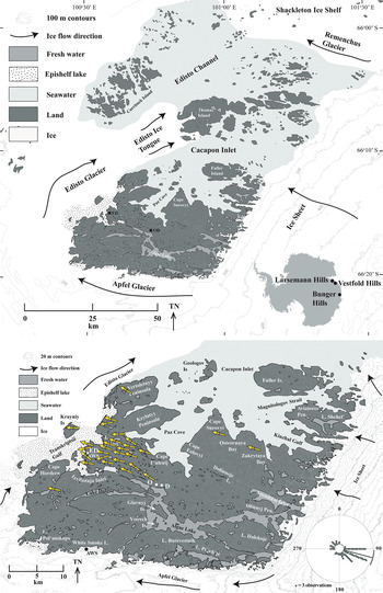
East Antarctica has recently been the focus of research into the magnitude and timing of its potential contribution to postglacial sea-level rise (Mackintosh et al. Reference Mackintosh, White, Fink, Gore, Pickard and Fanning2007, Reference Mackintosh, Golledge, Domack, Dunbar, Leventer and White2011, Reference Mackintosh, Verleyan, O'Brien, White, Jones and McKay2014, Bentley et al. Reference Bentley, Ó Cofaigh, Anderson, Conway, Davies and Graham2014), but one of the constraints in understanding regional ice loadings is the scarcity of presently ice-free land from which to reconstruct former ice sheet geometries. With a land area of > 400 km2, Bunger Hills is the second largest ice-free area in coastal East Antarctica, after Amery Oasis. Much of the land area is low lying, with heights of hilltops typically < 150 m above sea level (a.s.l.). Along the coastline of East Antarctica, where ice-free land is scarce, Bunger Hills contains important repositories of information regarding the deglaciation history of the ice sheet to the east, Apfel Glacier to the south and west and Shackleton Ice Shelf to the north (Fig. 1). Because of this regional significance for understanding former ice sheet geometries, contributions to late Pleistocene and Holocene sea levels and postglacial palaeoenvironments, it is important to continue to evolve our understanding of the surface environments of Bunger Hills.
Location of Bunger Hills and places noted in the text. Directions of orientated tafoni are shown as arrows. AWS = automatic weather station at Edgeworth David Base in the west and White Smoke Lake in the south.

Postglacial environments at Bunger Hills remain cryptic. In particular, although detailed lake and marine sedimentary archives are available (Melles et al. Reference Melles, Verkulich and Hermichen1994, Reference Melles, Kulbe, Verkulich, Pushina, Hubberten and Ricci1997, Verkulich et al. Reference Verkulich, Melles, Hubberten and Pushina2002, Berg et al. Reference Berg, Melles, Gore, Verkulich and Pushina2020), they are difficult to translate into an understanding of terrestrial environments. Lake cores 6078, 6082 and 6069 in Algae Lake (also known as Lake Figurnoe; Fig. 1), the largest lake in Bunger Hills and part of the Algae River drainage system (Gibson et al. Reference Gibson, Gore and Kaup2002), are particularly important as they contain marine diatom frustules (Verkulich et al. Reference Verkulich, Melles, Hubberten and Pushina2002) that might contain evidence of former wind directions that are different from those of the present day. Although they have been lacustrine cores since deglaciation, the oldest lacustrine parts of the cores from c. 9.9 to c. 6 14C ka bp contain a diverse but low-abundance marine diatom frustule assemblage (Verkulich et al. Reference Verkulich, Melles, Hubberten and Pushina2002). Mechanisms of emplacement of these marine diatoms in a freshwater core are: 1) erosion and redeposition of older, possibly glacially transported marine sediments, 2) rare incursions of seawater from Izvilistaya Inlet downstream (Verkulich et al. Reference Verkulich, Melles, Hubberten and Pushina2002) during an early Holocene part of a sea-level highstand, or 3) strong winds from the direction of marine inlets that may have entrained marine diatoms within sea spray.
The first of these alternatives is unlikely, as the former ice flow direction was towards the north-west (Adamson & Colhoun Reference Adamson and Colhoun1992, Augustinus et al. Reference Augustinus, Gore, Leishman, Zwartz and Colhoun1997), from the ice sheet and not across marine sediments. The second alternative is possible, although it is unclear why marine incursions were not common at the mid-Holocene sea-level highstand, unless epishelf Transkriptsii Gulf downstream had by that time developed a thick freshwater lens, as it has in the present day (Gibson & Andersen Reference Gibson and Andersen2002). This would preclude the presence of marine diatoms in the surface waters. Iceberg rollover in the narrow, shallow Izvilistaya Inlet would be unlikely to create waves large enough to wash over the c. 10 m a.s.l. sill into present-day Algae Lake. The final mechanism of emplacement is by dispersal of diatom frustules in sea spray from marine inlets. Long-range aeolian transport of marine diatoms has been invoked as a mechanism to account for a marine fossil component of glacial tills elsewhere in Antarctica (Scherer et al. Reference Scherer, DeConto, Pollard and Alley2016), and it may also be possible at Bunger Hills for wind to deposit marine diatoms in Algae Lake. This is most likely should strong winds blow from Paz Cove to the north at times when the sea ice had broken out (see also the discussion in Berg et al. Reference Berg, Melles, Gore, Verkulich and Pushina2020). This would imply strong winds that were different in direction from the dominant wind direction of today.
This paper summarizes the direction of modern-day winds and compares them with the orientations of elongated weathering pits, which can be considered to be a form of tafoni (sensu Groom et al. Reference Groom, Allen, Mol, Paradise and Hall2015) eroded into bedrock. We have observed identical elongated tafoni in similar, gneissic bedrock at Vestfold Hills, East Antarctica, which Pickard (Reference Pickard1982) used to reconstruct Holocene (postglacial) wind directions. We know that these elongated tafoni are old because they are not found in areas that have deglaciated recently, and if modern winds created them, then glacial erosional forms such as polish and striations would not survive anywhere. These are old features that have formed slowly. They have also formed under a strongly directional wind field, otherwise they could not have become elongated in one direction, and rather they would have widened to appear closer in form to honeycomb weathering.
Tafoni manifest in a range of forms across lithologies and climates (Groom et al. Reference Groom, Allen, Mol, Paradise and Hall2015) from continental (e.g. Calkin & Cailleux Reference Calkin and Cailleux1962, Prebble Reference Prebble1967, Strini et al. Reference Strini, Guglielmin and Hall2008) and maritime (e.g. Hall & André Reference Hall and André2006) Antarctica, to hot deserts (Mustoe Reference Mustoe1983). How tafoni - and particularly orientated tafoni - form in Antarctica remains little understood (Strini et al. Reference Strini, Guglielmin and Hall2008), but in Bunger Hills the process of chance coalescence of two or more nested tafone (see Paradise Reference Paradise and Shroder2013, stage 5, p. 117) is unlikely. At Vestfold Hills and Bunger Hills, tafoni were only found in areas of the most salt-weathered bedrock, suggesting a causal linkage between the intensity of physical weathering and the occurrence of tafoni, as occurs in deserts elsewhere and has been recognized for over a century (e.g. Jutson Reference Jutson1918). The presence of orientated tafoni appears unrelated to bedrock fractures (Strini et al. Reference Strini, Guglielmin and Hall2008) or chasmoendolithic lichens, which occupy fine cracks that connect to the rock surface (Guglielmin et al. Reference Guglielmin, Cannone, Strini and Lewkowicz2005, DiRuggiero et al. Reference DiRuggiero, Wierzchos, Robinson, Souterre, Ravel and Artieda2013). Chance formation of a small depression in the rock surface might allow hydraulic and salt crystallization (Bruthans et al. Reference Bruthans, Filippi, Slavík and Svobodová2018) mechanisms to perpetuate the pit, but the role of wind in the process of orientated tafoni initiation remains little understood. However, strong, directional winds must be implicit in their formation, as weak winds would be unable to carry abrasive sand-sized particles or remove sand particles from the rock surfaces.
Methods
Few weather data exist for Bunger Hills, as Oasis and Dobrowolski stations and Edgeworth David Base are occupied infrequently and for short durations. Weather data are presented from manual observations from Edgeworth David Base (January–March 1986; Bureau of Meteorology 2017) or from automatic weather stations (AWS) at White Smoke Lake (January 1992–July 1993; Doran et al. Reference Doran, McKay, Meyer, Andersen, Wharton and Hastings1996) and Apfel Glacier (January 2000–July 2001; Australian Antarctic Division 2017). Different forms of wind data were available from these sources, but they provide similar information. Where possible, data were collated from 2 m heights and only strong winds (> 10 m s−1; ‘strong breeze’, which is Beaufort wind force scale 6) were included, as only they are strong enough to create salty spray from the marine inlets and saline lakes and transport salt aerosols across the Bunger Hills.
Orientated tafoni were located while walking across every grid kilometre in southern Bunger Hills, and they were recorded where there were at least 20 clear occurrences at a site, except for one site where only six tafoni were found and measured. Some rock clasts were sampled and the geometry of the tafoni measured in the laboratory using three-dimensional scanning (0.1 mm resolution), with additional measurements using a digital depth meter (0.01 mm resolution). In the field, the orientations of tafoni eroded into bedrock and the valleys they were found in (where present; approximately half of the tafoni were found on flat-lying topography) were measured (n = 28 sites, n = 685 measurements). Summary statistics for tafoni and wind were calculated, pit size was compared using a t-test (Minitab Express 1.5.1, Minitab; α = 0.05) and tafoni orientations were compared with wind direction data using the Watson–Williams F-test, which is appropriate for circular data (Oriana 4.02, Kovach Computing Services; α = 0.05).
Results
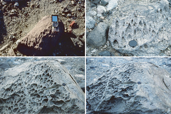
Orientated tafoni are relatively abundant in the north and north-western parts of Bunger Hills (Fig. 1 & Table SI) on coarse-grained granitic erratics and metamorphic erratics and basement. Fine grained rocks, which are relatively rare in Bunger Hills, become wind-polished ventifacts through abrasion from blowing sand, while medium- and coarse-grained rocks develop tafoni or undergo granular disintegration rather than cavernous weathering. Reasons for the development of orientated tafoni instead of the more abundant, unorientated tafoni remain unclear. Differences between some of these erosional forms (Fig. 2) reflect dip and dip azimuth of the eroding rock surface.
Orientated tafoni. Top left. Tafoni on granite, showing sharp demarcation between windward (bottom) and downwind (top) sides. Compass is 80 mm long. Top right. Orientated tafoni with well-developed downwind elongation, with apices pointed downwind. Wind direction bottom to top of photograph. Lens cap is 50 mm in diameter. Bottom left. Tafoni showing larger forms below, with orientated tafoni towards the top of the boulder. Wind direction bottom to top of photograph. Lens cap is 50 mm in diameter. Bottom right. The same boulder from a side elevation showing pit alignment and development on upwind (left) and downwind (right) sides of the boulder. Lens cap is 50 mm in diameter.

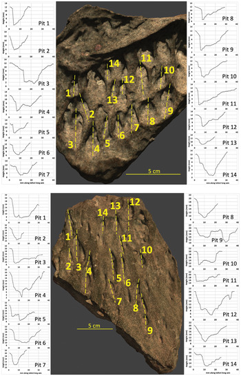
Orientated tafoni are only found in salt-enriched areas downstream of salt spray from marine inlets, particularly Paz Cove and Ostrovnaya Bay (Fig. 1). Orientated tafoni are asymmetric in the direction of wind and symmetric across wind direction (Figs 2 & 3), with the long axes parallel to former wind direction. Their forms are unrelated to grain boundaries, although rock mass strength must control their forms to an extent. Figure 3 shows the depth profiles of 14 orientated tafoni pits from each of a hard microgranite and a much softer gneiss. In the upwind direction, the pits are more open with a larger width/depth in the upwind direction (Fig. 3). In the downwind direction, the tafoni are typically asymmetric, being steeper, narrower and deeper than at the upwind end, and often close downwind in a characteristic pointed arch (Figs 2 & 3). On softer rock, tafoni are longer, wider and deeper than on harder rock (Fig. 3). The average width/depth ratio midway along the tafoni pits is greater in the softer gneiss (4.2 ± 1.2) than in the harder microgranite (2.6 ± 0.8).
Typical size and geometry of orientated tafoni in hand specimens, recorded in three-dimensional scans. Yellow numbers identify the tafoni pits; dashed lines show the long axes of the pits that were measured. Pit longitudinal profiles are sized similarly for comparison. For the rocks, palaeowind was towards the top of the page; for the charts, palaeowind was towards the left (0 mm on the x-axis). A distinct asymmetry (steeper on the downwind side) is apparent in most pits.

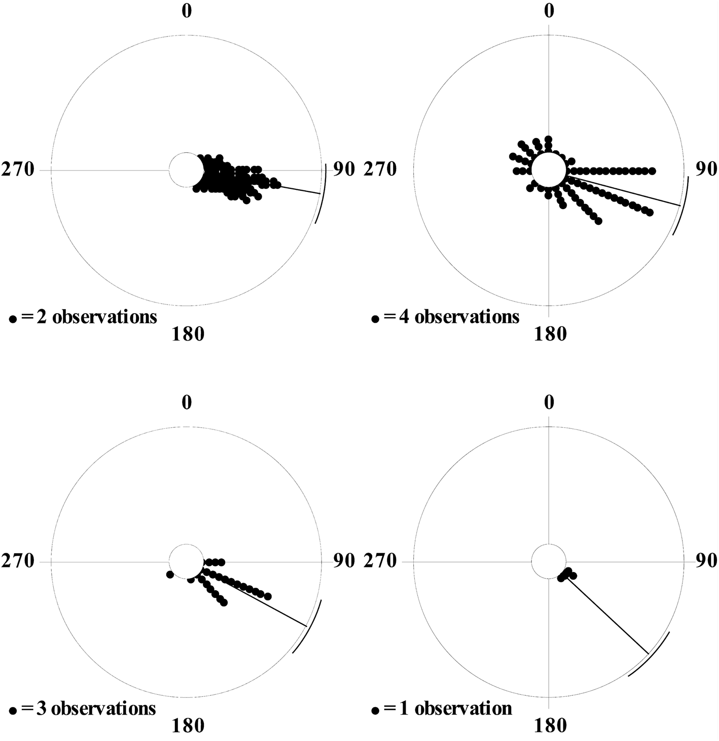
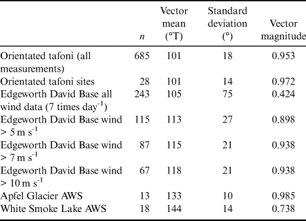
Mean orientations at each of the 28 tafoni measurement sites ranged from 070 to 126 degrees true (°T), with a mean of all sites of 101 ± 18°T (± 1 SD) (Figs 1 & 4, Table I & Table SI). There was no observable effect of valley alignment on the orientation of tafoni at the 28 sites, and so topography is discounted as having a significant effect on the orientation of the tafoni. Wind strength and azimuth were recorded on 243 occasions (seven times daily) at Edgeworth David Base from January to March 1986. Wind at Edgeworth David Base in 1986 had a binary distribution in direction, with stronger winds blowing from the ESE and gentler winds from the west on clear, sunny days with the formation of a gentle sea breeze. Winds > 10 m s−1 at Edgeworth David Base (n = 67 measurements) had a mean direction of 118 ± 21°T (± 1 SD). The AWS at the edge of Apfel Glacier (Fig. 1) from January 2000 to July 2001 recorded a remarkably uniform wind direction with a mean of 133 ± 10°T (± 1 SD), which is slightly more southerly than the wind data from the ice-free area of Bunger Hills just to the north, consistent with the slope of the ice surface near to where the AWS was installed.
Wind roses in degrees true for orientated tafoni and winds; means (radii) and standard deviations (arcs) are shown as solid lines. Top left. Orientated tafoni (each point is two measurements). Top right. Wind at Edgeworth David Base, January–March 1986 (each point is four measurements, each consisting of a 15 min mean direction). Bottom left. Strong winds (> 10 m s-1) at Edgeworth David Base, January–March 1986 (each point is three measurements, each consisting of a 15 min mean direction). Bottom right. Winds at Apfel Glacier automatic weather station, January 2000–January 2001 (each point is one measurement consisting of a monthly mean direction).

Summary statistics for the orientated tafoni and wind direction data.

Data sources: Edgeworth David Base AWS) (Bureau of Meteorology 2017), Apfel Glacier AWS data (Australian Antarctic Division 2017) and White Smoke Lake AWS monthly mean wind speed data (Doran et al. Reference Doran, McKay, Meyer, Andersen, Wharton and Hastings1996).
°T = degrees true; AWS = automatic weather station.
Orientated tafoni have similar orientations to strong winds (> 10 m s−1) recorded at Edgeworth David Base (F-test, F = 51.3, P < 0.001) and to winds at Apfel Glacier AWS (F-test, F = 42.0, P < 0.001). Orientations of strong winds at Edgeworth David Base and Apfel Glacier were also similar (F-test, F = 7.02, P = 0.01).
Discussion
The processes of formation and decay of the orientated tafoni (weathering pits) remain unclear. They have never been observed at Bunger Hills as large features, and while they only occur in areas with strong sea salt accumulation and rock weathering, it is not clear whether the main agent assisting orientated tafoni formation is salt crystallization pressure (Desarnaud et al. Reference Desarnaud, Bonn and Shahidzadeh2016), abrasion and plucking by fast-moving sand grains or both. Their orientation parallel to wind direction and consistently asymmetric geometries (Fig. 3) make them distinct from other tafoni forms, which are often circular, elongated along metamorphic grain and grow to large sizes (Fig. 2) through enlargement and coalescence with other tafoni. Orientated tafoni tend to remain small, and their morphology suggests that they deepen and elongate at the downwind end and erode out to form part of the rock surface at the upwind end. If this process is correct, orientated tafoni might be small erosional forms that can traverse slowly downwind along the surface of the rock, making them distinct in an additional way from other tafoni forms, which grow in situ.
The orientated tafoni show a similar orientation to that of present-day strong winds (Fig. 1 & Table I). Present-day strong winds are partly synoptic from passing low-pressure systems and partly katabatic due to gravity drainage of cold, dense air along the energy slope of the ice sheet. At Bunger Hills, these directions coincide, leading to a coincidence of strong winds from the ESE blowing to the WNW (Figs 1 & 4) that has persisted for thousands of years since the ice sheet attained its present orientation (Gore et al. Reference Gore, Rhodes, Augustinus, Leishman, Colhoun and Rees-Jones2001). Luminescence dating of glacial lake shorelines and glaciofluvial sediments (Gore et al. Reference Gore, Rhodes, Augustinus, Leishman, Colhoun and Rees-Jones2001) shows that the orientated tafoni occur only in areas exposed for at least the 10 000 year duration of the Holocene, and bedrock surfaces along the glacier edge and ice sheet margin do not exhibit these erosional forms. The presence of tafoni on ancient surfaces reinforces the idea that these features were formed by thousands of years exposure to palaeowinds rather than present-day winds, and that those palaeowinds have remained exceptionally uniform in direction. However, these ancient surfaces and the orientated tafoni also lie downwind of marine inlets, and it is also possible that the distribution of the tafoni is more related to extent of exposure to salty sea spray than to time since deglaciation (Gore et al. Reference Gore, Rhodes, Augustinus, Leishman, Colhoun and Rees-Jones2001). Further dating of the exposure ages of bedrock surfaces upon which the orientated tafoni occur might help to resolve the processes of their formation.
Reconstructed winds from Bunger Hills have blown from the ESE since deglaciation, as they do in the present day (Fig. 1). Consequently, every summer when lake and sea ice melt, salt spray blows over the land towards the west–north-west from every marine inlet and saline or hypersaline lake. This causes sea salt to be found on land surfaces downwind (WNW) of marine inlets and salt lakes (Gore & Leishman Reference Gore and Leishman2020) (Fig. 2). The surface sediments in those areas have become enriched in sea salt, forming evaporites seen in the present day in sediments and rock surfaces. As brine dries on rock surfaces, the growing salt crystals exert pressure (Desarnaud et al. Reference Desarnaud, Bonn and Shahidzadeh2016) on the rock surface, loosening mineral grains and leading to intense physical weathering of rock and glacial debris. At Vestfold Hills, where this phenomenon also occurs, the line delineating the salt-enriched area is known as the ‘salt line’ (Adamson & Pickard Reference Adamson, Pickard and Pickard1986, Gore et al. Reference Gore, Creagh, Burgess, Colhoun, Spate and Baird1996), which divides an area to the east that is rich in vegetation and with relatively unweathered bedrock from an area to the west where physical weathering of the metamorphic basement creates abundant sand and inhibits the growth of lichen and moss vegetation (Adamson & Pickard Reference Adamson, Pickard and Pickard1986). The uniform wind direction over many thousands of years has created a similar ‘salt line’ at Bunger Hills, affecting the distribution of rock weathering and the distribution and growth of salt-sensitive plants such as mosses and lichens (Gore & Leishman Reference Gore and Leishman2019, Leishman et al. Reference Leishman, Gibson and Gore2020). The direction of these strong winds is important for the distribution of salt spray, rock weathering and the distribution of vegetation at Bunger Hills, just as it is at Vestfold Hills (Pickard Reference Pickard1982, Adamson & Pickard Reference Adamson, Pickard and Pickard1986, Gore et al. Reference Gore, Creagh, Burgess, Colhoun, Spate and Baird1996) and Larsemann Hills (Kiernan et al. Reference Kiernan, Gore, Fink, McConnell, Sigurdsson and White2009) to the west.
Conclusions
Orientated tafoni (weathering pits) form in the central and north-western parts of Bunger Hills, where salt-enhanced physical weathering of bedrock and glacial debris occurs. The orientations of the tafoni indicate that strong winds since deglaciation have blown from the same direction: 101 ± 14°T (± 1 SD). This direction is similar to present-day strong winds, which blow from 118 ± 21°T (± 1 SD). Thus, ice sheet geometry has probably been stable for many thousands of years. The direction of these strong winds is important for the distribution of salt spray, rock weathering and the distribution of vegetation in Bunger Hills.
Acknowledgements
We thank the Australian Antarctic Division for logistical and financial support under grant AAS 926. We thank the Australian Antarctic Division and Australian Bureau of Meteorology for supply of and permission to use weather data, and we thank Sonja Berg, Martin Melles and Bernd Wagner for discussions on the diatoms of the Algae Lake cores. We thank Dan Zwartz for discussions on circular statistics, Mike Ashelford for help drafting Fig. 1, Michael Rampe for 3D scanning the specimens in Fig. 3 and John Pickard, David Hedding and Jeronimo Lopez-Martinez for helpful comments on the manuscript.
Author contributions
Both authors conceived the ideas and conducted the fieldwork, data analysis, writing and proofing of the manuscript.
Supplemental material
One supplemental Excel file will be found at https://doi.org/10.1017/S095410201900035X.