Introduction
Accurate and objective measurement of pasture biomass is a key requirement for producers for improving grazing system productivity, allowing graziers to better meet the feed requirements of their livestock. Accurate, real-time biomass estimates also enable producers to meet residual pasture targets, resulting in increased pasture utilisation, subsequently increasing pasture growth rates along with overall productivity (MLA, 2004; Westwood, Reference Westwood2008). Henry et al. (Reference Henry, Shovelton, de Fegely, Manning, Beattie and Trotter2013) estimate that improved grazing management decisions based on accurate estimates of pasture biomass has the potential to increase farm profitability by approximately 10% in Australian beef and sheep enterprises.
Current handheld technologies available for real-time pasture biomass estimation include rulers, light sensors, rising plates, capacitance probes, or vertical height and texture sensors. However, most commercially-available tools have been targeted at the dairy industry with relatively homogenous pastures. Their application to the generally more variable red meat pastures is limited due to cost, mode of deployment, and an inability to delineate the green fraction (Trotter et al., Reference Trotter, Lamb, Donald and Schneider2010). Active Optical Sensors (AOS) use their own light source to measure optical reflectance of the target canopy unaffected by ambient light conditions. Sensors that use red and near-infrared light reflected from the plant can provide the normalised difference vegetation index (NDVI) which correlates to the photosynthetically active biomass of the canopy. Active optical sensors have been used in the cropping industry (e.g. to infer crop nitrogen levels), however recent research has demonstrated the potential for applying the same technology to estimate the green fraction of pastures (Flynn et al., Reference Flynn, Dougherty and Wendroth2008; Trotter et al., Reference Trotter, Lamb, Donald and Schneider2010; Trotter et al., Reference Trotter, Schneider, Lamb, Edwards and McPhee2012). Although these sensors have been used in commercial arable crop production for some time (>10 years) their application and uptake in pasture has been slower than cropping due to the difficulties around deriving accurate calibration data. In previous work these sensors have been shown to accurately estimate pasture biomass up to 3 000 kg green dry matter (GDM) per hectare (Trotter et al., Reference Trotter, Lamb, Donald and Schneider2010). This range in biomass identifies AOS as a potential tool for pasture managers seeking to non-destructively monitor biomass within the optimal production range of 1 000 to 2 500 kg GDM/ha (MLA, 2004).
Here the potential of a relatively low-cost AOS (Trimble® GreenSeeker® Handheld (GS), approximately $700AUD) is assessed to estimate pasture biomass on grass-based pastures in northern New South Wales (NSW), Victoria and Tasmania, Australia. The reliability of the GS combined with height data was evaluated across a range of monocultures and mixed swards, across different seasons, regions and pasture growth stages.
Methods
Calibration cuts were collected over 2014–2015 from high rainfall zones (>700 mm per annum) at five locations in northern NSW, ten locations throughout Victoria, and four locations in Tasmania. Measurements were made during winter and spring in Victoria, also in autumn in Tasmania, and year-round in the Northern Tablelands of NSW. The sites grew tall fescue (Festuca arundinacea), perennial ryegrass (Lolium perenne), phalaris (Phalaris aquatica), and mixed-sward pastures with variable amounts of clovers. Data were collected from between 8 and 15 samples per site, obtaining a range in pasture biomass, pasture height, and NDVI values. Each set of cuts at a site represented a campaign. Before cutting the pasture, the NDVI was recorded using the AOS measured from 1 m, centered over the sample area. Height measure refers to that of the compressed pasture measured using a plate meter (Rayburn and Lozier, Reference Rayburn and Lozier2003). Then the pasture was cut in a 70 cm x 30 cm quadrat, designed to fit the footprint of the AOS. Post-cut NDVI was recorded, and photos were taken before and after cutting for quality control. The mass of the samples was recorded, then a subsample (at least 30 g) was sorted into green and senescent material. The subsamples and remaining samples were then oven dried for at least 48 hours at 70°C until a stable mass was achieved, and dry weights were recorded. The GDM and total dry matter (TDM) per hectare were then calculated. The groups collecting the cuts were trained to ensure consistent data quality, however samples that were not adequately cut (assessed from the site photos) were excluded from further analysis. Data analysis and modelling was performed in MS Excel (2013) and R (version 3.2.5, R Development Core Team, 2014). Campaigns were combined into regional groups according to season, proximity and pasture type, providing one regional dataset for the Northern Tablelands (NSW), three datasets in Victoria, and one in Tasmania. The distance between the locales representing the regions in Victoria was over 200 km, and was greater than 600 km between other regional sites (direct distances). ‘Season’ refers to a growing period, so winter to early spring were further combined, and a later spring campaign affected by hot or dry conditions was combined with summer. From these datasets, GDM was fitted against: NDVI; height; a combined NDVI x height index; and a log transformed height x NDVI. In each of the presented groups, the NDVI x height index model represented the best fits. Sampling in 2016 at the same sites and new sites will be used to test the validity of the models.
Results and Discussion
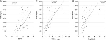
Green dry matter ranged from less than 60 kg/ha (ryegrass and phalaris pastures in autumn and early winter in Tasmania, Victoria and the Northern Tablelands) to 10 700 kg/ha (ryegrass in spring on the northern Tablelands), with 80% of the GDM between 370 and 3 800 kg/ha. In many campaigns, the NDVI ‘saturates’ with the GDM increasing steeply for only a limited increase in NDVI values (e.g. Figure 1a) as the scanned canopy prevents detection of the GDM below (Liu et al., Reference Liu, Qin and Zhan2012). This NDVI saturation necessitates the inclusion of height in the calibration models (Figure 1b) (King et al., Reference King, Sim and Barthram1986; Schaefer and Lamb, Reference Schaefer and Lamb2016). In some individual campaigns, height alone provided the better model, though this was uncommon, and occurred when only a restricted NDVI range (e.g. less than 0.2 NDVI units) could be sampled. These limited ranges in NDVI occurred in actively growing, relatively homogeneous green pastures. The combined NDVI x height was previously found by Schaefer and Lamb (Reference Schaefer and Lamb2016) to provide an improved correlation with GDM of tall fescue compared to the individual measures of NDVI and height for a single campaign. The example provided in Figure 1, with data from ten campaigns collected during winter-spring on four properties throughout the Northern Tablelands and includes ryegrass, phalaris and mixed sward pastures. The RMSE of the GDM for the ten combined campaigns improved from 735 kgha−1 forNDVI and 626 kgha−1 for height, to 537 kg ha−1 for the combined index. The results of the broader Northern Tablelands region was comparable to Schaefer and Lamb’s (Reference Schaefer and Lamb2016) data, indicating that it is feasible to develop regional calibrations of green dry biomass estimates for grass-based pastures.
GDM against a) NDVI, b) NDVI x falling plate height, and c) falling plate height relationships for combined data from ten winter-spring campaigns in the Northern Tablelands of NSW.

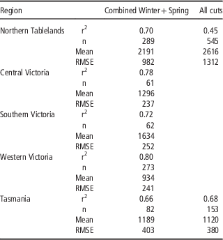
The calibrations of individual species were not significantly different from each other, so the data were grouped. The calibrations of combined GDM measurements made in winter to early spring more broadly in each region were moderately well correlated with the NDVI x height index (r2=0.62 to 0.77, Table 1). The winter-spring period is of key importance for southern producers, and the strength of the combined data provides confidence that regional calibrations can be deployed to provide objective estimates of GDM. The relatively large error (RMSE) associated with the models indicates the constraints when combining datasets, and further investigation into the pasture and environmental conditions (e.g. seasonal conditions, soil moisture, clover content) leading up to sampling are warranted. The combined data for the Victorian regions (spanning a direct distance of 450 km between sampling sites) had an r2=0.73 and RMSE=361 kg ha−1. The calibrations are presented for each region because the RMSE increased to too high a level for useful estimation (~600 kg/ha). Further refinement needs to consider the effects of bare soil and of senescent material in the pasture canopy that influence the NDVI measurement.
Statistical measures for the calibrations of green dry biomass against NDVI x falling plate height in grass-based pastures in NSW, Victoria and Tasmania

The effect of varying conditions on the calibrations is shown by the decreased reliability of the model when including the autumn and the summer cuts in the Northern Tablelands (Table 1). The majority of the additional cuts in the Northern Tablelands were taken on pure swards of the target species. The differences that emerged may reflect the different phenological responses of the species measured; these differences may not be so distinct in more mixed swards. In contrast, some individual campaigns taken at each site yielded better results (r2 up to 0.97). Such high individual correlations provide the scope for producers to tailor calibrations to their conditions.
The results highlight the ability of combined AOS and height measurements to estimate GDM. As the aim of developing accurate calibrations is to enable farmers to rapidly and objectively estimate biomass, a ready estimate of height is also required. To address this requirement, lidar has been flagged as a device to collect height data (Trotter et al., Reference Trotter, Andersson, Welch, Chau, Frizell and Schneider2016; Schaefer and Lamb Reference Schaefer and Lamb2016). In addition, a mobile phone application is being developed to calculate biomass in real-time using the calibrations. This application will also enable producers to generate and access their own new local calibrations that may provide more precise biomass estimates than the regional calibrations. There is also the potential to locally calibrate satellite remote sensing systems, thereby expanding the area and decreasing the frequency of manual pasture biomass assessments for livestock producers. Ideally, the development of combined units measuring height and NDVI, and providing real-time biomass estimates will provide a package that can be adopted by producers and lead to productivity gains in grass-based red meat production systems.
Conclusion
Accurate and reliable assessment of pasture biomass remains a key challenge for grazing industries. The GDM of tall fescue, phalaris, and perennial ryegrass, and mixed sward pastures in high rainfall zones of south eastern Australia was correlated with a combined NDVI x height index. The index was consistent with that found previously at a single site in northern NSW, providing encouraging signs that reliable regional calibrations for pasture biomass may be established that will improve graziers’ ability to manage their forage budgets. Remaining challenges in estimating the total pasture biomass accurately include the influence of mixed species within the pasture sward on NDVI, masking effect of senescent material and inability to measure it with an active optical sensor, and developing an optical means for easily obtaining a measure of height.
Acknowledgements
This work has been supported by the Cooperative Research Centre for Spatial Information (CRCSI, Project 4.18), whose activities are funded by the Business Cooperative Research Centres Programme and Meat and Livestock Australia (MLA, Project B.GSM.0010).