

1. Expert-influence in flood governance
Delta regions offer fertile agricultural land, provide good conditions for industrial production and are strategically located for international shipping and commerce. Historically, people have always been drawn to delta regions to utilize these benefits. However, life and work in the delta has always been challenged by severe flood incidents. Of all natural catastrophes, floods already cause most insured damages world-wide and more losses are projected in the years to come (Swiss Re, Reference Swiss2012; UNISDR, 2015).
In standard governance approaches, the risk of flooding is dealt with by national governments. They invest in levees, floodwalls and other structural flood defenses to keep floods at bay, and often also compensate the private losses in case this protection fails. In recent decades, this standard governance approach has come under pressure. In an era where climate change drives up the flood risk, levees and floodwalls may create a ‘false’ sense of safety that draws more people to flood-prone areas, only adding lives and value to flood-prone areas, while public compensation schemes do not offer any incentive to limit or reduce flood damage at the local level (Hartmann, Reference Hartmann2009; Kunreuther, Reference Kunreuther2006).
Against this background, many national governments have started to diversify their ‘safety’ approaches by incorporating ‘spatial-planning measures’ in their governance strategy (Bubeck et al., Reference Bubeck, Botzen and Aerts2012; Hegger et al., Reference Hegger, Driessen, Dieperink, Wiering, Raadgever and Van Rijkswick2014). Spatial-planning measures consist of a combination of land-use management regulations (e.g. restricting developments in high-risk areas) and price incentives (e.g. reflecting the costs of floods in insurance premiums) to encourage damage mitigation at the local level (Woltjer and Al, Reference Woltjer and Al2007). While spatial-planning measures are generally presented as a ‘cost-effective’ alternative to state-funded flood protection (Botzen and Van den Bergh, Reference Botzen and van den Bergh2008), this shift significantly changes the distribution of costs and responsibilities in flood governance. Responsibilities are transferred from the national to the local and individual level where planning, location and building choices are made, and costs shift accordingly (Bergsma et al., Reference Bergsma, Gupta and Jong2012; Butler and Pidgeon, Reference Butler and Pidgeon2011; Meijerink and Dicke, Reference Meijerink and Dicke2008; Penning-Rowsell and Pardoe, Reference Penning-Rowsell and Pardoe2012).
From a democratic perspective, it is important that such distributive shifts in public governance are dealt with by democratic decision-making bodies, which ensure the representation of different views and interests in the decision-making process (Rawls, Reference Rawls1999). With the recognition that climate change can be postured as a new threat that needs to be ‘securitized’ in order to maintain basic human wellbeing, the procedures under which adaptation solutions are formulated have been questioned (Corry, Reference Corry2012; Lange and Garrelts, Reference Lange and Garrelts2007; Von Lucke et al., Reference Von Lucke, Wellmann and Diez2014). As pointed out by scholars of the risk-society, in such situations of threat policymakers tend to rely heavily on the rational-technical knowledge of experts to reduce uncertainty and maintain their authority (Beck, Reference Beck1992; Ewald, Reference Ewald, Burchell, Gordon and Miller1991). Consequently, concerns have risen about the scope of expert-influence in risk governance (Habermas, Reference Habermas and Regh1996; Jasanoff, Reference Jasanoff2004; Rosanvallon, Reference Rosanvallon2008). Authors have started to explore the possibilities of implementing more direct (Rosanvallon, Reference Rosanvallon2008), deliberative (Warren, Reference Warren2006), associative (Hirst, Reference Hirst2002) or regulatory (Majone, Reference Majone1999) forms of democratic governance to better ‘control’ and ‘check’ the influence of experts in risk governance. However, such studies are often very theoretical and do not consider the way in which experts actually influence democratic decision-making (Spruijt et al., Reference Spruijt, Knol, Vasileiadou, Devilee and Lebret2014). This paper takes a step back in this development. It aims to analyze the effects of expert-influence on distributive decision-making in the empirical context of the turn to spatial-planning measures in flood governance.
These effects are explored in two national case studies. The first case study analyzes the turn to spatial-planning measures in the United States (US), where a spatial-planning approach emerged in the 1940s and institutionalized over time. The second case study analyzes this turn in the Netherlands, where flood governance has been dominated by a safety paradigm and spatial-planning measures have recently been implemented in addition to structural flood defenses. The question guiding the analysis is: What experts were involved in the Dutch and US turns to spatial-planning measures in flood governance, and how have these experts influenced distributive decision-making in this process?
The paper is structured as follows. In the next section, the theoretical framework and research approach are presented. Section 3 describes the turn to spatial-planning measures in US flood governance, and Section 4 describes this turn in the Netherlands. Section 5 comparatively analyses the case-study findings to draw conclusions about the constitution of experts and the effects of their influence in the turn to spatial-planning measures in both countries, which may be relevant for other countries that are currently seeking to implement spatial-planning measures as part of a new flood governance strategy. The conclusion reflects on these findings from a theoretical perspective.
2. Theoretical and analytical framework
A micro-perspective on institutional change
This paper uses institutional theory to grasp the move to spatial-planning measures in flood governance. In the broadest sense, institutional theory looks at the structures that shape social interaction. These structures emerge from regularities in actors’ daily behaviors that solidify as patterns that continue to structure actors’ behavior over time (e.g. social conventions or norms, see Weber, Reference Weber, Roth and Wittich1978: 23–31; Giddens, Reference Giddens1984). Thus, institutions have strong path-dependent characteristics. As March and Olson (Reference March and Olsen1989) and North (Reference North1990) famously argued, this structuring force of institutions can be strengthened as behavioral patterns are incorporated in formal rules and formalized practices in different (political, economic, cultural) domains of life.
From this basic understanding of institutions, different strands of institutional theory have been developed (Lowndes, Reference Lowndes, March and Stoker2010). Historical institutionalism, for example, focuses on explaining the durability and change of large-scale socio-political systems such as communism or certain forms of democracy. Institutional economics or rational-choice institutionalism typically analyses patterns in rational-economic behavior. Sociological institutionalism aims to understand how institutions are shaped and reshaped in their (political, cultural, economic, etc.) context.
This article builds on the sociological strand. It understands institutions to be embedded in a wider political, cultural, economic and physical context. Institutions emerge from this context and are reproduced in this context. Within this strand, institutional change is usually explained from changes in this external context, which create openings for prevalent institutions to be questioned, challenged and changed (Kingdon, Reference Kingdon1995). Over the years, the role of political agency in creating these openings and steering the direction of institutional change has been highlighted (Arts and Van Tatenhove, Reference Arts and Van Tatenhove2004; Clemens and Cook, Reference Clemens and Cook1999).
Within the sociological strand, there is a quite some ambiguity as to how context and agency factors relate to each other in processes of institutional change (Brousseau et al., Reference Brousseau, Garrouste and Raynaud2011; Fuenfschilling and Truffer, Reference Fuenfschilling and Truffer2014; Hodgson, Reference Hodgson2007; Kingston and Caballero, 2009). Big institutional transformations are often explained from a combination of external shock events and political agency (Birkland, Reference Birkland1997; Hajer, Reference Hajer1995). However, it is increasingly recognized that institutions are constantly in flux. Such ongoing changes can best be analyzed from a micro-perspective that conceptualizes institutional change as a gradual process of institutional adaptations to changing contextual circumstances and strategic action, working both to produce and resist change (Gray et al., Reference Gray, Purdy and Ansari2015; Hall and Taylor, Reference Hall and Taylor1996; Mahoney and Thelen, Reference Mahoney, Thelen, Mahoney and Thelen2010).
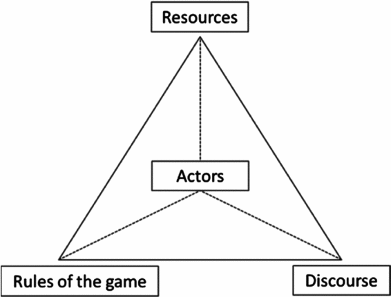
To grasp the micro-dynamics underlying institutional change, the policy arrangements framework developed by Van Tatenhove et al. (Reference Van Tatenhove, Arts and Leroy2000), Arts and Van Tatenhove (Reference Arts and Van Tatenhove2004) and Arts, Leroy and Van Tatenhove (Reference Arts, Leroy and Van Tatenhove2006) provides useful concepts. In this framework, institutions are located in policy fields as ‘policy arrangements’, which denote ‘temporary stabilizations in the content and organization of a policy domain’ (Van Tatenhove et al., Reference Van Tatenhove, Arts and Leroy2000: 54). The framework distinguishes between different elements of a policy arrangement: a discourse dimension, an actor dimension, a rules dimension and a resources dimension (see Figure 1). The discourse dimension structures the content of a policy field. It refers to the interpretative repertoire actors use to provide meaning to, and derive meaning from, a situation (Hajer, Reference Hajer1995; Wetherell and Potter, 1988). The actor, rules and resources dimensions structure the organization of a policy field. The actor dimension encapsulates the array of actors at play in a policy field. The rules dimension encompasses the formal and informal rules that guide actors’ actions. And the resources dimension comprises the allocation of resources over different actors.
The policy arrangements framework (Arts et al., Reference Arts, Leroy and Van Tatenhove2006: 99).

The policy arrangements framework can be used to analyze the drivers behind institutional change at a micro-level. In the policy arrangements framework, change can occur at every dimension of a policy arrangement, the structural features of the policy arrangement determining the opportunities for and directions of change at each dimension (Arts and Van Tatenhove, Reference Arts and Van Tatenhove2004: 5). Because all dimensions are interrelated, change brought about at one dimension can prompt shifts at other dimensions as well, causing gradual shifts in the policy arrangement. With the framework, the authors take an empirical stance in the structure-agency discussion. The relative weight of contextual and strategic drivers of change can differ along dimensions, policy fields and temporal areas and should therefore be analyzed empirically.
In this paper, the policy arrangements framework will be used to analyze the effects of expert-influence on the turn to spatial-planning measures in flood governance in the US and the Netherlands. Understanding this turn in terms of a process of institutional change, the policy arrangements framework can help to understand how expert-influence is constituted at the actor dimension of the policy arrangement in US and Dutch flood governance, and how this institutionalized expert-structure changes, or endures, in response to external (e.g. climate change may challenge existing policy approaches and the body of expertise on which they rely) or agency (e.g., when actors highlight the (in)appropriateness of existing policy approaches) drivers.
When it is understood how expert-influence is constituted in US and Dutch flood governance, the effects on distributive decision-making can also be analyzed. For this, the policy arrangements framework also offers a useful starting point. Changes in the constitution of expert-influence at the actor dimension may have impact on the other dimensions of the policy arrangement in flood governance. For example, a new type of expert may change the policy discourse on floods, based on which new policies are developed that bring forward new distributions of costs and responsibilities in flood governance.
Case studies and data
As explained above, the transition to a spatial-planning approach in flood governance is understood as a gradual and contextually embedded process. This research topic is well suited for a case study approach, as it allows incorporating a multitude of internal, external and agency factors, as well as their interplay (Yin, 2009: 13). Considering the institutional spectrum encompassing the turn to spatial-planning measures, Dutch and US flood governance are two ‘extreme cases’; in the US, a spatial-planning approach already institutionalized in the mid-20th century, whereas spatial-planning measures have only recently and moderately been incorporated in Dutch flood governance. According to Yin (Reference Yin2009, p. 52), extreme cases may ‘reveal insights about normal processes’, which are more difficult to detect in ‘typical’ cases. Their findings may spotlight certain issues, which may provide valuable starting points for further analysis in typical cases (Seawright and Gerring, Reference Seawright and Gerring2008: 298).
While US and Dutch flood governance are extreme cases, both countries face comparable flood risks. They share some important characteristics that have been identified by Bolognesi (Reference Bolognesi2015) as decisive factors in determining water-related risks (both type and intensity). The US and the Netherlands have a similar level of socio-economic development, their coastal and river-basin areas are already highly developed and constantly face new claims on land, and socio-economic centers are relatively evenly distributed over the national territory. This means that the lessons drawn from the case studies will particularly be of relevance to countries that share these characteristics.
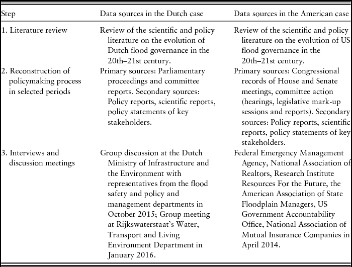
Because institutional change is understood as a long-term process, institutional analyses require a long-time frame (Hajer and Laws, Reference Hajer, Laws, Goodin, Moran and Rein2008). The case studies underlying this paper cover a time period of roughly a century, from the early decades of the 20th century up to recent decades. To focus the analysis, a three-step approach was followed. First, the main policy developments in 20th and 21st century Dutch and US flood governance were mapped out based on a literature review to identify the underlying structures of expertise. Second, the analysis zoomed in on certain moments in this evolutionary path during which important distributive aspects in flood governance were shaped. For these periods, the policymaking process was reconstructed based on transcripts of parliamentary and congressional records to trace back how experts influenced distributive decision-making. Third, the conclusions of each case study were checked and fine-tuned through stakeholder interviews and discussion meetings. In the Dutch case study, the discussion meetings mainly served to check the findings with (knowledge) actors involved in the ‘executive’ domain of Dutch policymaking on floods whose role was not well documented in the parliamentary records; in the US case, the interviews were used to generate insight into the contextual factors that impacted on recent policy developments. Table 1 provides an overview of data sources.
Overview of data sources

3. The US spatial approach to floods
The institutionalization of the spatial-planning approach in US flood governance
In the early decades of the 20th century, US flood governance was characterized by a strong reliance on technical flood protection. However, the engineering solutions that characterize the safety approach always met with a great deal of controversy in the American society. The federal resources that were needed to build levees and floodwalls, deepen out rivers and widen flood streams conflicted with leading political principles such as individual responsibility and the local autonomy of states (Barry, Reference Barry1997).Footnote 1 Their implementation involved a continuous struggle over the level of state funding vis-à-vis that of ‘local contributions’ of states, and rising federal payments on disaster relief met with increased opposition as well (Arnold, Reference Arnold1988).
In the 1940s, a new group of experts connected to the Chicago School of behavioral sciences – a scientific movement that studied possibilities for adjusting behavioral patterns through governmental policy – started to criticize engineering solutions in US flood governance (Platt, Reference Platt, Kates and Burton1986). It were in particular social geographers connected to this school who argued that levees make people feel safe and therefore allow value to accumulate in flood-prone areas. Absent in the engineering approach, geographers argued, was a consideration of the costs of damage; because these costs were shouldered by the federal government through disaster relief, there was no incentive to mitigate flood damage at the local level (White, Reference White1945). In the geographers’ ‘rational floodplain management’ alternative, these costs would be reflected in price incentives that would encourage local actors to make a rational trade-off between the costs and benefits involved with living in a floodplain. While in some cases technical flood protection would still be cost-effective, geographers argued that in many other cases investing in damage mitigation measures or relocating developments to less flood-prone areas provided a more cost-efficient alternative.
The geographers’ spatial approach sided well with American politics of the 1950s and 1960s, where Chicago School scientists had fostered a discourse of rational state planning. A proposal was drafted for a National Flood Insurance Program (NFIP) that would offer price incentives for rational floodplain management. This would be done by linking the availability of flood insurance to local communities’ enactment of building codes and zoning requirements in flood-prone areas (which meant no insurance was offered in communities that had not imposed land-use restrictions on high-risk areas), and by charging risk-based premiums to encourage property owners to take damage mitigation measures (e.g. using water-resistant building materials or elevating the ground floor). When this proposal was discussed in Congress, concerns arose over the high costs of flood insurance in high-risk (mainly coastal) areas (90 Cong. Rec., 1967: H17279). With its adoption in 1968, important decision-making responsibilities for flood governance were decentralized to the local level. However, Congress also set a cap on annual premium increases and included a federal subsidy on premiums of existing properties in high-risk areas to ensure the affordability of flood insurance.
From the start, the insurance program struggled. To get the program up and running, all the flood hazards in the US needed to be identified and mapped, which proved an immense task (Riebau, Reference Riebau, Marsalek, Watt, Zeman and Sieker2000). Mapping delays undercut community participation in the program which hampered the build-up of sufficient financial reserves (Pasterick, Reference Pasterick, Marsalek, Watt, Zeman and Sieker2000). This led to discussions on the need to allow communities to enroll based on non-actuarial or subsidized rates. Another discussion centered on the prolonged use of structural flood defenses by local communities: What rules should be set regarding land-use and risk-based pricing in levee-protected areas? These discussions reduced political support for the NFIP as a policy approach for flood governance.
Support for the program was upheld by a strong collaboration between geographers and environmental organizations in the 1970s, whose nature protection goals coincided well with the NFIP´s aim to limit developments in coastal and riverine areas (Reuss, Reference Reuss1992). Through this collaboration, a Water Resources Council was formed as a federal advisory body on water management, which issued a great number of reports that outlined new and stricter building and zoning guidelines for the NFIP (e.g. US Water Resources Council, 1971). However, this growing emphasis on spatial-planning restrictions within the NFIP elicited concerns from local-communities, who feared new land-use requirements would bring ‘economic disaster’ to their regions (Subcommittee on Housing and Urban Affairs, 1973: 85).
In 1973, major reforms were made to the insurance program. Land-use and building regulations were tightened and flood insurance was mandated for federally-backed properties in high-risk areas. At the same time, federal subsidies on insurance premiums were increased and hazard mitigation grants were made available to assist individuals and local communities to mitigate flood damage (Subcommittee on Housing and Urban Affairs, 1973: 47–70). Through these reforms, the federal government extended its influence on local spatial-planning and in return increased its financial contributions to the program (Arnell, Reference Arnell1984).
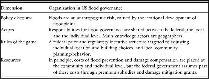
In the 1940s to 1970s, US flood governance ‘turned’ from a safety to a spatial-planning approach. Through this turn, policy institutions changed (see Table 2). A new policy discourse emerged that relied on the geographers’ often paraphrased claim that while ‘[f]loods are the acts of God, flood damages are the results of the acts of men’ (HUD, 1966: 14). The policy solution that was developed (the NFIP) addressed the human causes behind flood risks by encouraging individuals and local communities to stay away from high-risk areas. This new policy fundamentally altered the constitutions of actors, rules and resources in the policy field. Geographers became key knowledge holders in US flood governance. Under their guidance, important responsibilities and costs for dealing with floods shifted from the federal to the local level as a result of the implementation of the NFIP. By providing information about local flood risks and about the options available to individuals and communities to mitigate flood damage, these experts offered insight into the local-level impacts of this new policy approach in flood governance. This facilitated an evaluation of its distributive consequences at the federal level; in the policy discussions on the NFIP, affordability was always factored in.Footnote 2
The policy arrangement underlying the US spatial-planning approach

The further development of the US spatial-planning approach
The 1970s reforms helped to increase participation in the NFIP (Platt, Reference Platt, Kates and Burton1986). However, many insurance policies were subsidized and the program regularly had to borrow money from the Federal Treasury to cover the damage after a flood. When Reagan's conservative regime rose to power in the 1980s, the large federal contributions to the program backlashed against its neo-liberalist ideology. Again, reforms were made. In 1981, the management of the NFIP was delegated to the Federal Emergency Management Agency (FEMA), a newly created federal agency for disaster management. Under FEMA's supervision, the program was directed towards fiscal independence, which meant that mean annual losses (calculated based on historical claim data) should be covered by mean annual premium revenues (Committee on Appropriations, 1981). By reducing subsidies on premiums, FEMA obtained a self-supportive status in 1986.
These positive developments generated confidence in FEMA's management capacities. The organization was trusted with the daily operation of the NFIP and policymakers turned their attention to more pressing threats such as international security and terrorism in the 1990s. Attention for the insurance program was again raised by hurricane Katrina, which broke through all records as the costliest natural disaster ever experienced in the US (Michel-Kerjan et al., Reference Michel-Kerjan, Lemoyne de Forges and Kunreuther2012: 645). After more than nineteen years of fiscal independence, FEMA borrowed an exceptional amount of 19 billion US$ dollars from the Federal Treasury to cover all claims (Michel-Kerjan Reference Michel-Kerjan2010: 176). Soon after the hurricane, questions were raised about the functioning of the program: Wasn't the NFIP designed to reduce flood damage, and the role of the federal government in damage compensation, in the first place?
After a long line of policy discussions, Congress reformed the insurance program in 2012. These ‘Biggert-Waters reforms’ aimed to improve the financial and regulatory structure of the NFIP by phasing out subsidized premiums and phasing in risk-based rates that instead of looking backwards, took account of future catastrophic losses (Subcommittee on Housing and Community Opportunity, 2010: 1–9; 156 Cong. Rec., 2010: H5625; 158 Cong. Rec., 2012: H4621-23). When the reforms started to be implemented, they produced sky-high premium increases that in some cases even went up as high as the whole value worth of the property (New York Times, 2013).Footnote 3 In Congress, everyone looked at FEMA to stop these extraordinary rate increases, but FEMA's hands were tied by the new law (Subcommittee on Economic Policy, 2013). In 2014, Congress passed the Homeowners Flood Insurance Affordability Act to scale back the rate increases triggered by the Bigger-Waters Act. When hurricane Sandy in 2012 again cut into the NFIP's budget, new directions have been explored in US flood governance. With projects such as ‘rebuild by design’ – a design competition between different options for a resilient rebuilding of Sandy-affected areas – more emphasis seems to be placed on structural flood protection.
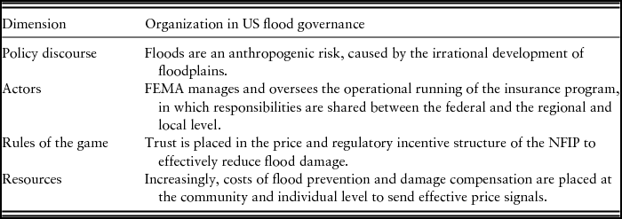
As the spatial-planning approach further institutionalized in US flood governance in the 1980s, trust was placed in the self-regulatory character of the spatial-planning measures included under the NFIP and FEMA's operational expertise in managing this program (see Table 3). However, while on paper the NFIP's financial balance continued to match up, in practice the flood risk had exacerbated due to a complex combination of factors including climate change, overdue technical maintenance of levees, a difficult enforcement regime for damage mitigation regulations and population dynamics.Footnote 4 However, because the program's management was entrusted to FEMA, its principles were not re-evaluated in the light of these changed circumstances. Because of this, the impact of Katrina was unanticipated and the distributive implications of new reform measures were hard to grasp.
Shifts in the policy arrangement underlying the US spatial-planning approach

4. The turn to spatial-planning measures in the Netherlands: From engineering protection to engineering space
The engineering approach to flood protection
In the Netherlands, centralized flood management emerged in the late 19th century. Against the background of an internationally rapidly developing science on floods and water management, Dutch civil engineers sought to expand their influence by highlighting the benefits of large-scale water engineering works for the Netherlands (Lintsen, Reference Lintsen1980). Joining hands with macro-economists, their plans typically not only specified the technical aspects of engineering works but just as important also their national costs and benefits (Den Hoed and Keizer, Reference Den Hoed and Keizer2007).
These engineering plans corresponded well with the ideology of the rising progressive-liberal elite in Dutch politics around the end of the 19th century, whose members preferred a more active role of the central state in public affairs (Baneke, Reference Baneke2011). Close bonds developed between members of this new elite and engineering association. Under their collaborative efforts, engineering plans were further tailored to specific political needs, which often generated the necessary support for the realization of engineering plans in Dutch politics.
A good example of this is provided by the construction of the Afsluitdijk, a 32-kilometer long dam that enclosed the former inlet of the Zuider Sea, turning it into a large freshwater body that rich plots of agricultural land. Inspired by successful inland land reclamations in the second half of the 19th century, engineers started to explore the possibility of damming a whole sea – the Zuider Sea – to reclaim land. Organized into the ‘Zuider Sea Society’, engineers closely collaborated with national economists and business leaders to advocate their Afsluitdijk plan in Dutch politics. At first, it encountered much resistance. The plan was technically unprecedented, required vast governmental investments and would dissolve the fisheries sector operating on the Zuider Sea. By building strong bonds with the rising progressive-liberal elite, the Zuider Sea Society became well aware of the doubts and questions that obstructed the realization of their plan. The organization put a lot of effort in addressing these concerns. Numerous reports were produced in which the technical aspects were worked out in more detail (Zuiderzeevereeniging, 1892), the costs were better specified and the long-term benefits were quantified (Van der Houven van Oordt and Vissering, Reference Van der Houven van Oordt and Vissering1901), the ‘bad shape’ of this fisheries sector was underlined (Zuiderzeevereeniging, 1905), and the urgency of the project for flood protection and economic growth was highlighted (Zuiderzeevereeniging, 1916). By tailoring their knowledge to political concerns, the Zuider Sea Society managed to generate political acceptance for their project. The plan was formally approved in 1918 and the Afsluitdijk was completed in 1932.
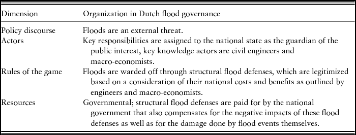
The Afsluitdijk represents a formative moment in the history of Dutch flood governance. In the policy discourse, floods were understood as an external threat to the optimal functioning of society that should be dealt with by the central state in its capacity as guardian of the public interest. Policy solutions rested on a combination of engineering and macro-economic expertise that specified the national costs and benefits involved with engineering solutions. These cost-benefit analyses provided the evaluation framework for decision-making. Dealing with the local-level disadvantages of engineering projects, such as that for fishermen, was left to democratic politics as this involved a question of national solidarity. In case of the Afsluitdijk, fishermen were partly compensated for their losses by the national government.
This policy arrangement institutionalized and came to underlie the safety approach in Dutch flood governance (see Table 4). It, for example, supported the realization of the famous Dutch Delta Works, a system of ‘movable floodwalls’ devised by a leading Dutch engineering organization and constructed after a devastating storm surge in 1953. These works were funded by the national government, and negative local-level impacts (e.g. on the fisheries industry and on communities that had to make way for construction) were compensated (Stb. 1958, 246).Footnote 5 Dutch flood governance thus developed as a national-state responsibility, where decisions were made based on national cost-benefit analyses produced by engineers and macro-economists. Under this institutional arrangement, distributive questions were settled by Dutch parliament on an ad-hoc basis. Over the years, a generous damage compensation practice emerged in which the national government not only compensated for the negative effects of flood protection works themselves, but increasingly also for the damage done in case these defense structures failed (Kuks, Reference Kuks2004: 96).
The policy arrangement underlying the Dutch safety approach

The spatial turn in Dutch flood governance
As a flood control strategy, spatial-planning measures were for the first time discussed in the 1990s. In this decade, high water levels in some of the country's main rivers accumulated into riverine floods in 1993 and a near-flooding disaster 1995. In addition, recurring rainfall extremes between 1998 and 2002 led to a number of flood incidents that caused repeated damages. A policy advisory committee on water management set up in 2000 argued that rather than to continue relying on flood protection, the Dutch needed to start accepting floods from time to time and focus on reducing their consequences by reserving more space for water in the national landscape (WB21, 2000). Following this advice, a number of policies have been introduced to implement spatial-planning measures (Jong and Van den Brink, Reference Jong and Van den Brink2013). Below, three of these policies are discussed in more detail: the Room for the River project, flood insurance and the Second Delta Program.
Under the general header of Room for the River, several river-widening projects were launched to create more space for water. As this Room for the River program started out in 1996, the national government assumed a leading role. Leaving the technical design options to engineers, it used its authority to designate areas for river-widening and restricted building activities in riverbeds. Foregone revenues lost due to these planning restrictions were reimbursed through a special damage compensation arrangement (Kamerstukken II, 1996/1997a). Still, however, the planning restrictions often conflicted with local community's spatial-planning goals, as river beds provided productive development areas (Kuks, Reference Kuks2004: 121–129). In 2006, the national government loosened its building requirements but – after years of guaranteeing flood safety to its residents – started to emphasize the responsibility of local actors in the riverbed to deal with the damage caused by possible flood events (VenW and VROM, Reference VenW and VROM2006). Flood insurance was proposed as a means to help local actors cope with this new responsibility (Kamerstukken II, 2005/2006).
Flood insurance was already discussed in the subdomain of flood damage compensation. The 1990 floods not only challenged the arbitrary nature of the ad-hoc damage compensation arrangements that characterized Dutch flood governance, but also these arrangements were after the 1990 floods criticized for creating a moral hazard because people have no incentive to prevent damage as long as they know the government will compensate their losses (Kamerstukken II, 1994/1995). Flood insurance would solve these issues by providing an orderly method of damage compensation and providing local-level actors with an incentive for damage mitigation. While different proposals were made to set up a public-private flood insurance scheme, these proposals always encountered resistance. Policymakers generally felt that flood damage compensation was a matter of national solidarity that should be dealt with by the national-democratic parliament (Kamerstukken II, 1995/1996).
Instead of flood insurance, a new damage compensation law was adopted in 1998. This law not only laid out standard rules for damage compensation, but also preserved the national government's freedom to adjust these rules to specific cases and situations. The law explicitly only arranged for partial damage compensation and excluded the compensation of insurable damage to emphasize citizens’ responsibilities in the area damage mitigation (Kamerstukken II, 1996/1997b). However, in the policy discussions leading up to this law, the implications of this new responsibility put on the shoulders of individuals were scarcely recognized. While policymakers generally agreed that individuals should be encouraged to take flood damage compensation measures themselves, questions about the options citizens actually have in this respect, and how much this would cost them, were barely discussed. Also in subsequent discussions on flood insurance in the Netherlands – which up to today has still not been implemented – questions of this sort have seldom been raised.
In 2008, the launch of the Dutch Second Delta Program – the first was set up after the devastating flood in 1953 – put a new emphasis on spatial-planning measures. With this program, the national government wants to bring its flood protection policies up to speed with climate change. Within this program, a group of professionals affiliated with key Dutch engineering organizations were tasked to developed new ‘economically efficient’ protection standards for the Netherlands (IJgenraam et al., Reference Eijgenraam, Kind, Bak, Brekelmans, Den Hertog, Duits, Roos, Vermeer and Kuijken2014). These norms will provide every Dutch citizen with a basic safety level expressed as a chance of being killed by a flood of no more than once every 100 years. In addition, flood protection will be reinforced in areas that represent important economic value or where there are a lot of people at risk. For low- to medium-risk (mainly rural) areas, the Delta Plan forwards spatial-planning measures as a more cost-efficient alternative. Because spatial-planning measures require ‘shared ownership’ and ‘self-regulation’ (Delta Program, 2014: 8), the new norms require a larger contribution of individuals and businesses in low-risk areas than in high-risk areas. These distributive implications were, however, not discussed in the policymaking process leading up to the adoption of the new safety norms. Spatial-planning measures were generally justified as a ‘cost-efficient’ option in low- to medium-risk areas (Kamerstukken II, 2010/2011, 2013/2014, 2015/2016), but questions related to which actors would actually take on ‘shared responsibility’ in self-regulatory governance networks were not raised.
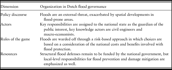
Since the 1990s, some elements of the institutional arrangement in Dutch flood governance shifted (see Table 5). The policy discourse no longer understood floods solely as an external threat but as a problem partly caused by local-level planning and building decisions. New spatial-planning policies were devised that aimed to better address these causes. As the spatial turn in Dutch flood governance started out under the Room for the River project, responsibilities remained largely governmental. Gradually, however, spatial-planning policies started to emphasize local-level responsibilities for flood prevention and damage mitigation. However, because these measures were legitimized through the national cost-benefit analyses produced by engineers and macro-economists, who continued to provide the dominant source of expertise in Dutch flood governance. Under their national-level focus, local-level distributive implications of spatial-planning measures were not always recognized in the policymaking process. Strikingly, the implementation of spatial-planning measures has been examined within geography and spatial economy departments of major Dutch knowledge institutes (e.g. Aerts and Botzen, Reference Aerts and Botzen2011; De Moel et al., Reference De Moel, Van Vliet and Aerts2014; Kok et al., Reference Kok, Van Vliet and Klijn2014; Paudel et al., Reference Paudel, Botzen, Aerts and Dijkstra2015; Wolsink, Reference Wolsink2006). However, the institutionalized science-policy interactions at the actor dimension of the Dutch policy arrangement seemingly prevented the uptake of this new body of knowledge in the policymaking process.
The policy arrangement underlying the Dutch spatial-planning approach

5. Conclusions and discussion
This paper provided an account of expert-influence in the turn to spatial-planning measures in US and Dutch flood governance, in order to analyze the effects of expert-influence on distributive decision-making underlying these turns. This was done against the background of concerns about the increased reliance on expert-knowledge in risk governance, which has been documented to not only shape the ‘technical’ aspects of new policy approaches but also their ‘political’ or ‘distributive’ underpinnings. The question this paper set out to answer was: What experts were involved in the US and Dutch turns to spatial-planning measures, and how have these experts influenced distributive decision-making in this process?
First, a conclusion can be drawn about the constitution of expert-influence in US and Dutch flood governance. As the case studies described in this paper reveal, a safety approach developed both in the Netherlands and the US at the end of the nineteenth century as it was based on the expertise available at that time, i.e. engineering rivers and building levees to ward off floods. Consequently, flood governance emerged as a central-state responsibility in both countries. However, this safety approach developed in two very different contexts. In the Netherlands, it fitted in nicely with the political landscape of the Netherlands at the late 19th century where the rise of progressive liberalism paved the way for larger state involvement in Dutch flood governance. However, the safety approach never fully landed in the US where values of individual responsibility and local state autonomy were prioritized over large-scale state involvement. In addition, the specific nature of flooding in the US, where hurricane-driven storm surges can cause catastrophic flooding disasters, has always put the effectiveness of safety measures to the test; it is a famous American saying that there are only two kinds of levees, those that have failed and those that will fail. Whereas the safety approach institutionalized in Dutch flood governance, US policy makers willingly embraced the alternative floodplain management approach developed by geographers.
Based on these insights, the paper concludes that expert-influence in Dutch and US flood governance can best be described as ‘contextually-embedded’. While policymakers were dependent on expert-knowledge to develop flood governance strategies, the case studies show that the influence of experts was also shaped by interactions with policymakers who drew up the boundaries within which experts could organize their solutions in flood governance. This was not only so in the emergence of the safety and spatial-planning approach in Dutch and US flood governance. The US case study in particular demonstrates that expert-influence can also be adjusted to changing political goals and values. When market regulation became the cornerstone of US politics in the 1980s, trust was placed in the management capacities of the FEMA and important management responsibilities for the NFIP shifted to this regulatory agency.
A second insight derived from the case studies is that contrary to general assumptions, the involvement of experts in Dutch and US flood governance did not automatically imply that the distributive implications of policy approaches were downscaled to technical discussions and overlooked in the policymaking process. Due to the contextually embedded nature of expert-influence, the close relationships that developed between experts and policymakers pushed experts to better outline the (distributive) implications of their plans, which actually facilitated the recognition of potential areas of conflicting needs and interests. In the Netherlands, the socio-economic costs-benefit analyses produced by engineers provided insight into the (national to local-level) disadvantages of large-scale flood defense works, which could be dealt with by additional democratic decision-making on an ad-hoc basis. In the US, the interaction with social geographers provided policymakers with information on local insurance premiums and (the costs involved with) damage mitigation measures, implications which could be traded off against the aim to send effective price incentives for damage mitigation under a spatial-planning approach.
Third, however, this does not mean that no problems were identified with the involvement of experts in the turn to spatial-planning measures in US and Dutch flood governance. However, rather than connecting these problems to the involvement of experts per se, the findings of the case studies warrant a more nuanced conclusion that looks at the involvement of specific types of expert-groups in specific governance settings. While more so in the US than in the Netherlands, costs and responsibilities shifted to the local level under the move to spatial-planning measures in flood governance. In the US, the distributive implications of this turn were specified by social geographers whose affiliation with the Chicago School of Behavioral Sciences implied a focus on implications for individual behavior. In the Netherlands, spatial-planning measures were outlined by institutionalized engineering experts. Under their guidance, Dutch spatial-planning measures have been justified based on their national-level cost-efficiency; they are seen as a legitimate option for low- to moderate-risk areas where the investments in structural flood protection do not outweigh the expected benefits created by defense works. Under this nationally oriented engineering focus, the local-level distributive implications of spatial-planning measures were, however, not recognized in the policymaking process.
In the US, the challenge was different. While new forms of ‘geographical’ expertise were organized into the policymaking process on floods in the mid-20th century, the main challenge in this context has been to uphold the interaction between spatial experts and policymakers in flood governance in order to ensure a continuous re-evaluation of the distributive implications of the spatial-planning policy. When management responsibilities for the NFIP shifted to FEMA in the 1980s, the focus came to lie on the operational running of the program which directed the attention away from changing distributive implications under the increased flood risks posed by climate change.
As the results of this paper indicate, there is a lot more to be said about how experts impact on distributive decision-making than is usually credited for in the literature on this topic. The conclusions call for further research that looks beyond the role of experts as a general category in public policymaking, but that instead focuses on the effects of the inclusion of specific types of expert-groups in a contextualized governance setting. It is important that these effects are better understood in the context of flood governance. When new allocations of costs and responsibilities brought about by the turn to spatial-planning measures are not recognized and dealt with, this can not only hamper an effective implementation of new spatial-planning approaches as actors may be unaware of the new responsibilities assigned to them, but it may also undermine the legitimacy of this new policy approach because their distributive outcomes are insufficiently legitimized in the policymaking process.
In this paper, US and Dutch flood governance were analyzed as ‘extreme’ cases in the turn to spatial-planning measures. The policy arrangements framework was used to understand how expert-influence was constituted in these two cases, and how this impacted on distributive decision-making. This research set-up provided a useful starting point to identify challenges with respect to the involvement of experts in this institutional turn. To refine the conclusions of this article, future research could use the policy arrangements framework to explore the extent to which these challenges apply in more ‘typical cases’ where safety and spatial-planning elements are combined in more ‘integrated’ approaches to flood governance.