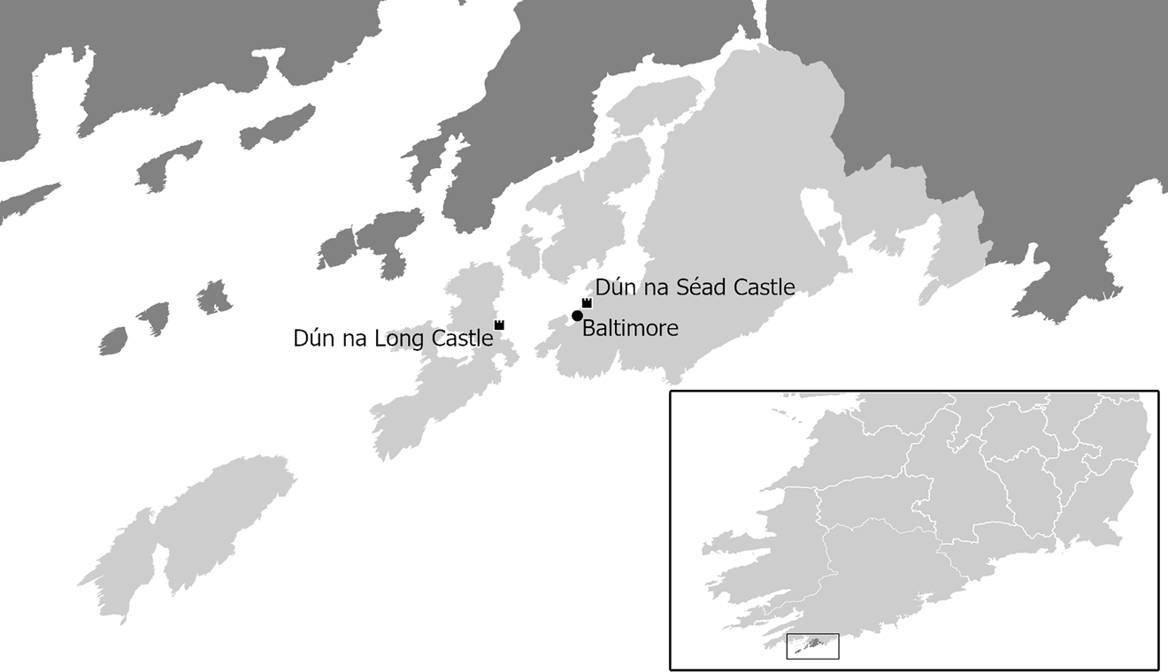



In 1628, Donnchadh Carrach O'Driscoll of Sherkin Island, County Cork, brought a chancery suit against his relative, Sir Finghín O'Driscoll of Ballyisland, over possession of Collymore, the coastal territory that centred on the bustling port of Baltimore.Footnote 1 (See Figures 1 and 2.) Donnchadh complained that, decades earlier, his father Finghín Carrach O'Driscoll had been wrongfully deprived of his half of Collymore by Sir Finghín, who had been aided in his incursion by his father-in-law and overlord, Sir Owen MacCarthy Reagh.Footnote 2 Donnchadh sought redress in the form of the lands and rents that (he argued) by tradition and legal precedent should have descended to him. There was little hope of success. By the time of the suit, nearly all of the original parties were dead and there was little money or property to collect in the slim chance that he was successful. Just three years later, the sack of Baltimore by pirates would further devastate the region, and the subsequent decades of rebellion and land confiscation would damage the O'Driscolls’ standing beyond recovery.Footnote 3 However, Donnchadh's suit was about more than reclaiming the vestiges of his ancestors’ inheritance. At stake were the legal foundations of Gaelic land tenure and property ownership in the evolving legal landscape of plantation Ireland.
O'Driscoll Mór family tree delineating the two branches. This data is compiled from the primary sources discussed throughout this article.

Map of Collymore, approximated by comparing modern townland boundaries and those marked on the Down Survey against locations referenced throughout the legal documents surrounding the disputes. This map uses two shapefiles from the Ordnance Survey Ireland National Statutory Boundaries dataset, both licensed under a Creative Commons Attribution licence: townlands, available at https://data.gov.ie/dataset/townlands-osi-national-statutory-boundaries1 (accessed 20 July 2021), and counties, available at https://data.gov.ie/dataset/counties-osi-national-statutory-boundaries1 (accessed 23 July 2021). The digitised Down Survey maps and terriers are available via the Down Survey Project at Trinity College Dublin, https://downsurvey.tcd.ie/ (accessed 16 May 2021). Collymore is represented across three parish maps: Creagh, Baltemore [sic], and Castlehaven, all in the barony of Carbury [sic], County Cork.

The lordship of Collymore was no stranger to litigation. Donnchadh's 1628 suit was just one in a long series of similar legal entanglements about the territory's ownership that stretched back over several centuries. The conflict to which Donnchadh sought resolution was on the surface merely an inheritance dispute between two cousins. As that internal dispute escalated, however, each claimant turned to external authorities and sought the support of settlers and local power brokers, enmeshing the land and lordship of Collymore in a legal and bureaucratic morass from which it could not be extricated.
These conflicts derived in large part from a tension between the two prevailing legal systems. On one hand were the customary practices of partible inheritance and Gaelic lordship. Most notable among these practices was that referred to by English contemporaries as tanistry, in which the lordship descended to the most eligible among a group of relatives and potential heirs, rather than a direct patrilineal descendant.Footnote 4 Native systems of inheritance, including the practice of tanistry, had been subject to internal pressures since the fifteenth century.Footnote 5 But stronger efforts at anglicisation through the Tudor reconquest and plantation sped up and intensified the process. By the late sixteenth and early seventeenth centuries, customary practices were gradually eroding in the face of stricter implementation of English common law, which sought to replace tanistry with primogeniture and in general enforce Englishness through legal mechanisms. Tanistry was a particular target of Sir John Davies, who waged a deliberate and sustained campaign against it via the Irish judiciary.Footnote 6 The result was a wide spectrum of hybrid practices as various constituents attempted to bend these systems in their favour.Footnote 7
Legal hybridity or pluralism in early modern Ireland produced an adaptable suite of tools and strategies for defending or pursuing one's interests amid the overlapping, sometimes contradictory, legal jurisdictions. ‘Forum shopping’ constituted one such strategy. In her work on Sumatra, Keebet Von Benda-Beckmann uses the term ‘forum shopping’ to describe the practice of litigants ‘bas[ing] their choice [between different institutions] on what they hope the outcome of the dispute will be, however vague or ill-founded their expectations may be’. For early modern Irish litigants, available fora for civil suits included the common law courts in Dublin (the four courts of king's bench, common pleas, exchequer and chancery), the assize circuits, and regional and local courts, as well as local arbitration outside the court.Footnote 8 Notably, von Benda-Beckmann's use of the forum shopping paradigm also recognises the existence of ‘shopping forums’, in which legal venues choose and arbitrate cases to suit the political ends of the institution. The paradigm, therefore, also accounts for Davies's use of the courts to combat tanistry and other Irish precedents, even as parties to the Collymore case forum shopped to defend it. Parties ‘forum shopped’ for the most beneficial site of arbitration, evaluating the merits of each legal system for their own interests, borrowing from one or the other, or moving fluidly between them as it suited their present needs.Footnote 9 Chancery was a particularly popular site of arbitration, thanks in part to its favourable view of precedent, even when it contradicted the tenets of common law.Footnote 10 Surviving chancery records document a broad spectrum of legal pluralism: plaintiffs asking English administrators to uphold Irish practices that were technically illegal; Irish suitors deploying arguments rooted in English law; and occasionally Old English families following Irish customs like partible inheritance.Footnote 11 Because of this reputation for flexibility, the court of chancery became one of the primary stages on which the tensions and cultural exchanges of plantation Munster played out, drawing cases from all levels and sectors of Irish society.Footnote 12 Much of the drama surrounding Collymore is preserved in chancery records. However, the courts were only one site and strategy of several employed by the territory's claimants.
Collymore was a microcosm of the tensions between the systems of inheritance, systems of land tenure, and sources of authority that characterised Gaelic and English lordship in the early modern period. In addition to internecine conflict over the lordship's title, the disputes surrounding Collymore also drew into question the relationship between the O'Driscolls’ traditional MacCarthy Reagh overlords and the planters who had rented or mortgaged the land.Footnote 13 The escalating conflicts over this lordship between cousin and cousin, overlord and underlord, and native and Munster plantation settler (the plantation having been revived after the Nine Years War) were symptomatic of shifting fault lines in the legal institutions and principles governing land ownership in plantation Ireland. In response to broad legal transitions occurring at the highest levels of society, the ever-increasing number of claimants to Collymore employed a wide array of legal strategies, some calling on medieval precedents and others reimagining their legal standing in light of these new norms. Collymore, became a battleground on which ideological conflicts over the source and nature of authority and land tenure were waged.
The parties to these conflicts included not only Sir Finghín and Donnchadh Carrach, but their fathers, grandfathers, and children; the MacCarthy Reagh lords who enjoyed a long history as O'Driscoll overlords; Old English neighbours, like Sir Walter Coppinger; and newcomers to the Munster plantation like Thomas Crooke. Motives were similarly varied. For Sir Finghín and Donnchadh Carrach, the stakes were rightful inheritance and the historical precedent that underpinned their claims. The MacCarthy Reagh lords were concerned with the nature of their authority (if any) over this small but significant corner of their lordship of Carbery. For Thomas Crooke and Walter Coppinger, the issue was in part a financial one. They had invested a great deal of capital in Collymore and needed to protect their assets. But for Coppinger, Crooke and their compatriots, the financial stakes were also contingent upon their commitment to the larger Tudor-Stuart project of plantation and their personal investment in the communities in which they lived. The men at the centre of these suits thus also represented the wide array of motives and conflicts within the broader plantation project.
It is a truism that these transitions within Irish society in the sixteenth and seventeenth centuries and native responses to them were intensely regionalised. Harold O'Sullivan persuasively laid out this case in 2004, but even before his formulation, regional histories marked out peculiarities of place.Footnote 14 The social, political and economic particulars and historical contingencies of Ireland's distinct regions ensured that English settlers and the plantation project were received differently in each community. For that matter, the same historical contingencies shaped English policy toward those regions, where plantation was only one of many possible outcomes. Less often noted, however, are the variations within individual lordships at the local level. The case of Collymore isolates points of dissension within a small kingroup and reveals how legal mechanisms were weaponised not only on the large scale along ethnic, economic and political lines, but on the smallest, most granular levels by rival claimants to a lordship, a title, or just a particular parcel of land. It also illuminates the agency with which individuals received, rejected, or negotiated Tudor-Stuart policy toward Ireland and understood national trajectories through the lens of local circumstance.
The struggle for control of Collymore is captured by an unusually intact record. At the centre are three chancery cases that reveal distinct dimensions of contestation: the internecine conflict between Donnchadh Carrach and Sir Finghín; a dispute between Owen MacCarthy Reagh and the planter Thomas Crooke over MacCarthy Reagh overlordship; and a belated attempt by Sir Finghín to reclaim the lands and authority he had ceded to Walter Coppinger.Footnote 15 The chancery records are supplemented with fiants, patent rolls, inquisitions, and other materials. Together, this corpus sheds new light on evolving patterns of land tenure and sources of authority.
I
While this drama played out on an early modern stage, the roots of the conflict were medieval. O'Driscoll lordship over Collymore stretched back centuries, predating the arrival of both Anglo-Norman settlers and the MacCarthys, who would assert themselves as the O'Driscolls’ overlords as they dominated the region in the twelfth and thirteenth centuries.Footnote 16 Like many of their neighbours, the O'Driscolls had experienced a great deal of factionalism within the lordship over the thirteenth through fifteenth centuries. Across Carbery and across Ireland, inheritance and succession disputes gave rise to new, distinct kingroups.Footnote 17 So although the 1620s conflict was the most significant and impactful in the longue durée of the lordship, it was certainly not the first.Footnote 18
The most recent phase of reorganisation of the O'Driscoll lordship, which precipitated the seventeenth-century disputes, had begun in the early sixteenth century when the lordship of Collymore was split in two by Conor mac Finghín, father of Finghín Carrach, and Conor mac Conor, father of Sir Finghín.Footnote 19 Under the initial agreement, Conor mac Finghín received the demesne of Dún na Long, along with half the lands and rents of the O'Driscolls and half the royalties of Baltimore Harbour. Conor mac Conor received the demesne of Dún na Séad (Baltimore), along with the other half of all the lands, rents, and royalties. The division of Collymore between Conor mac Finghín and Conor mac Conor in effect hybridised the English and Irish systems of inheritance, preserving a semblance of collective ownership of the lordship while also reifying the two lines and ensuring that each parcel was inherited through primogeniture from that point onward. While the origins of the dispute that led to this settlement are obscure, the conflict and resolution fit a broader pattern of disputes over seniority and succession taking place in Gaelic lordships throughout the preceding century.Footnote 20
This clean, even division of lands between the two O'Driscoll lines lasted only a generation, and the new emerging conflict bore key differences from earlier iterations of inheritance disputes. Upon Conor mac Conor's death in 1573, Sir Finghín inherited Dún na Séad and his father's half of the income. However, when Conor mac Finghín died, Sir Finghín intruded upon that half too, depriving Finghín Carrach of his inheritance and violating the terms of the agreement. Previous internecine conflicts had resulted in new lineages and distinct lordships, but in each case, the resulting kingroup and polity still maintained some continuity of identity — that is to say, while the two O'Driscoll lines of the sixteenth century had become distinct political and territorial units, they were both still O'Driscolls. The 1628 case had begun much the same way with Sir Finghín's intrusion on the land. But the disposition of the ill-gotten lands was essentially different. Within fifteen years, Sir Finghín had mortgaged the bulk of the lordship to planters like Thomas Crooke, alienating it from O'Driscoll ownership entirely. What had begun as an internal fracture became a mechanism by which Sir Finghín aided the plantation of the O'Driscoll lands in exchange for financial security (which, though he did not know it, would be fleeting).
II
At the centre of the web of suits and testimonies was the inheritance dispute between Donnchadh Carrach and Sir Finghín. This dispute began with the alleged intrusion of Sir Finghín upon Finghín Carrach's lands in the 1580s, and the ensuing legal battle carried on for decades. As a result, many of the details of the case come from the Donnchadh Carrach's 1628 suit. This suit illustrates the range of legal strategies available to these two Irish claimants to a Gaelic lordship, with Donnchadh Carrach deploying Irish law, Sir Finghín rooting his claims in the English concept of land tenure, and both wielding their social networks as political leverage.
Born around 1588, Donnchadh Carrach was too young to have participated directly in the initial proceedings himself (he testified in 1628 that his father's death in 1600 had left him ‘an infant of the age of twelve yeares’), yet he constructed a compelling historical narrative for the court.Footnote 21 He made two main allegations: first, Sir Finghín had unlawfully deprived Finghín Carrach of lands that by longstanding tradition should have been his; and secondly, because of their personal ties, the O'Driscolls’ overlord Owen MacCarthy Reagh (‘a man of verie great power & com[m]and’) had unjustly aided Sir Finghín in doing so by bestowing upon him the white rod that symbolised the title of O'Driscoll and all the concomitant political and financial benefits.Footnote 22 At the core of the case, therefore, were two complaints rooted in Irish law and custom: a violation of established inheritance practices and a violation of the proper relationship between overlord and underlord. These two complaints rested on a common assumption of the validity of Irish legal practice and asked the court of chancery to uphold precedent and custom rather than the letter of English law.
In his response to Donnchadh Carrach's suit, Sir Finghín denied the allegations completely. He in turn accused Donnchadh Carrach of weaponising his own family connections, alleging that he
[bore] himself upp stiffe as well uppon the strenght and countenance of Sr Walter Coppinger knight (a powerfull and potent gentleman) as also uppon the Might, and great Meanes of Richard Coppinger, whose daughter is Married to the Compl[ainan]t, And therefore labo[re]th to vex and molest these defend[an]tes uniustly and to putt them to unnecessary Expences in lawe.Footnote 23
Sir Finghín also rejected Donnchadh Carrach's historical narrative, denying that the earlier settlement had ever taken place. He asserted that he had always been in possession of the entire territory of Collymore and that Donnchadh Carrach was his tenant rather than a rival claimant. While Sir Finghín also sought to establish a veneer of precedent, employing the ubiquitous ‘time out of mind of man’ trope, his main strategy hinged upon discrediting Donnchadh Carrach on both personal and historical grounds — despite an inquisition in 1608 that supported the latter's narrative.
These two chancery records speak to a wide spectrum of legal strategy, rhetoric and social and political networks deployed by Sir Finghín and Donnchadh Carrach. In addition to direct testimony, other sources reveal a rich web of conflicting interests and challenges to legitimacy in which the parties took to the courts and other sites of arbitration to lay out their legal claims. The comments of administrators and other contemporaries fill out the narrative of this internecine dispute. They paint a rich picture of Sir Finghín's early strategies for establishing and defending his authority and legitimacy in the wake first of his inheritance and second of his incursions, as well as Finghín Carrach and Donnchadh Carrach's efforts to combat him.
After his father's death in 1573, Sir Finghín immediately moved to secure his inheritance. Even at this early stage, a decade before his own incursions, Sir Finghín was mindful of the legal threats to his land tenure. Finghín Carrach did not yet have cause to undermine his claims, but Sir Finghín faced early challenges to his legitimacy from Sir Peter Carew. Carew claimed descent from Robert Fitzstephen, one of the original grantees of Cork under Henry II, and on that basis argued that a vast swathe of Irish lands, including much of Cork, rightfully belonged to him.Footnote 24 In 1568, Carew began a lengthy legal campaign to reclaim his alleged inheritance. By 1573, Carew and his attorney John Hooker believed that they had the current landholders on the defensive, including Sir Finghín. Hooker wrote to Carew that the nobility of Munster
for the most have given over their own titles, and taken their livings of the prince, and daily doth like; and now presently Fynon O'Drisco is come hither to Dublin for the same purpose, and mindeth very shortly to come over unto you. They think by these means to avoid you.Footnote 25
Sir Finghín had indeed approached the queen in order to surrender his lands for regrant, backed by the commendations of both Lord Deputy Fitzwilliam and Sir John Perrot.Footnote 26 He expressed a great deal of urgency, noting that the lack of response to his repeated petitions was ‘a greate hinderaunce and not without sore losses to your highnes pore suppliant’, although it is unclear whether he was motivated by Carew's counterclaims or merely by a desire to secure his standing following his father's recent death.Footnote 27
The support of influential voices in court like Perrot, Fitzwilliam and Sir Henry Sidney was an important resource for Sir Finghín, who had evidently petitioned the queen without success prior to their vouching for him. This leveraging of social and political connections, even minor ones, was a strategy he would employ in his later dealings. Their support derived from shared concerns about eliminating Irish legal precedents and circumventing Carew's claims. Although various parties acknowledged that Carew's claims had some technical merit, his plan alienated many of the gentry and threatened to upset the delicate balance of power within Munster, a region which spent much of the sixteenth century on the brink of rebellion or in all-out war. Carlow offered a warning: there, Henry Sidney's support of Carew's claims was one of the factors that prompted the Butler revolt in 1569. When tasked with evaluating the merits of Carew's claims in Munster and redistributing land accordingly, Sir John Perrot (then lord president of Munster) declined, noting ‘what hazard the state was brought vnto’ by the Carlow case and arguing that Munster would be far worse, as the lands involved belonged to ‘most of the wildest and strongest in Mounster’.Footnote 28 Sir Finghín, on the other hand, had so far proven himself loyal and capable of keeping the peace. In 1576, he was among those Irish lords whom Henry Sidney acknowledged had ‘enough land (with good order) to live like a knight’, indicating both the region's wealth (and the administration's interest in it) and his relatively stable governance.Footnote 29 Moreover, Perrot noted that Sir Finghín's surrender and regrant would disincentivise mischief and ‘drown the yll custome of the Thaniste’.Footnote 30 In 1583, he was at court again, where he received approbation from both William Cecil and the privy council. He maintained this good reputation for decades.
Sir Finghín's visible, consistent loyalty and connections to the crown were particularly important for maintaining his legitimacy in the eyes of the crown and the colonial administration as Munster slipped further into rebellion. Besides being of interest as a potential revenue generator, Baltimore's strategic coastal location made it a suspected hub for Spanish spies carrying information to and from Ireland and a potential landing point for enemy ships.Footnote 31 With the threat of Spanish intervention looming (through both the Second Desmond Rebellion and the Nine Years War), the administration maintained a vested interest in the loyalties of the region's leaders. Courting the good graces of the government, therefore, required active work on Sir Finghín's part, for instance by levying his influence on his father-in-law and overlord Owen MacCarthy Reagh in the crown's favour. In 1583, Sir Warham St Leger vouched for Sir Finghín's loyal behaviour in influencing MacCarthy Reagh to provide one hundred soldiers for the queen's service.Footnote 32 Sir Finghín was, thus, able to utilise his family ties to lend further legitimacy to his political authority over Collymore and Baltimore.
Sir Finghín's relationship with Owen MacCarthy Reagh (r. 1576–93, d. 1594) was a mutually beneficial one, rooted in both political affinity and kinship. This was the crux of Donnchadh Carrach's complaint about their overlord–underlord relationship, that Owen had unfairly granted Sir Finghín unearned authority based on their familial ties. Owen, ‘for the better advancem[en]t of the s[ai]d s[i]r ffinin & his s[ai]d daughter … gave him a rodd in Confirmacion of the s[ai]d Title or Style of ó driskoll morr’.Footnote 33 Donnchadh Carrach claimed that it was upon the authority of this act of investiture (or nepotism, in his view) that Sir Finghín ‘w[i]thowt anie Cullor of r[igh]t wrongfully and w[i]th strong hand hath entered upon the s[ai]d ffinin [Carrach] ó driskoll’.Footnote 34 Owen MacCarthy Reagh's support of Sir Finghín, Donnchadh Carrach argued, had supplied him with the necessary political capital to enact his coup.
The matter of MacCarthy Reagh overlordship was not a settled one, though, and the alliance formed with Sir Finghin through investiture was equally important to Owen's legitimacy. Owen MacCarthy Reagh's position as lord of Carbery was subject to similar tensions as those in the O'Driscoll lordship: Owen had succeeded his three elder brothers as lord of Carbery, following the rule of seniority common to the practice of tanistry. But Owen's position was hotly contested by Domhnall na Pípí MacCarthy Reagh, his nephew by his eldest brother. Domhnall na Pípí maintained (and was supported by the administration in doing so) that he held the more legitimate claim to the lordship by primogeniture.Footnote 35 The support of underlords like Sir Finghín was crucial to maintaining Owen's overlordship in the face of staunch opposition. Thus, Sir Finghín and Owen MacCarthy Reagh were mutually dependent upon one another to support each other's contested lordships.
Meanwhile, by the early 1580s, Conor mac Finghín had died, leaving his half of the lordship of Collymore to Finghín Carrach, who employed his own legal strategies to defend his authority (albeit less successfully than his cousin). Later testimonies establish that Sir Finghín almost immediately intruded upon this land, leaving Finghín Carrach to fight for his inheritance for the next decade and a half.Footnote 36 But in 1585, it was one Finghín mac Conor mac Finghín mac Conor who appeared at Perrot's parliament, along with dozens of other Irish lords.Footnote 37 This has been read by others as an error in the pedigree, intended for Finghín mac Conor mac Conor mac Finghín, i.e. Sir Finghín.Footnote 38 While this is one possible solution, the existence of a Finghín mac Conor mac Finghín with an equal claim to the lordship of Collymore presents the equally plausible answer that Finghín Carrach appeared at Parliament and that he surrendered his lands for regrant. Such a grant under English law would have protected his interests against Sir Finghín. The incident raises the very strong possibility that for a brief time Finghín Carrach successfully acted as the (or a) chief O'Driscoll, or at least the head of his own sept. The identity of the O'Driscoll at parliament hinges upon the pedigree — the exact relationship between Conor mac Conor and Conor mac Finghín is unclear, and therefore it is impossible to say whether the pedigree given in the 1585 annals entry is correct. However, Collymore was surrendered for regrant in that year, and whichever Finghín did the surrendering, the motives were likely the same in either case: to seek local legitimacy from an external authority in the face of internal dissension.Footnote 39
The surrender and regrant of Collymore (certainly by Sir Finghín in 1573, and perhaps again by Finghín Carrach or Sir Finghín in 1585) had ostensibly ‘extinguished the Irish right’ of tanistry and of overlordship, doing away with the ‘former custome … that the eldest of the familie succeeded, unto whome Mac Cartie Reagh did give a rod, and then he was reputed and obeyed as lord of the Countrie of Collimore’.Footnote 40 Yet, Sir Finghín did in fact receive a rod from Owen MacCarthy Reagh. Laying claim to the lordship across these multiple legal contexts displays a strategically flexible identity and an awareness of the looming threats to Irish land tenure. In seeking multiple sources and affirmations of his authority, Sir Finghín followed his father-in-law's example. Owen had spent his tenure as lord of Carbery playing the roles of both Tudor aristocrat and Irish overlord, taking part in the same inauguration rituals (for the O'Donovans and O'Mahonys, as well as the O'Driscolls) that Tudor administrators regarded with such suspicion and disdain, even as he touted his loyal support to queen and privy council. Inaugurations were as important to Owen as to his underlords, affirming his (contested) authority as MacCarthy Reagh and strengthening his local support base.Footnote 41
By 1586, Sir Finghín was confident of his control over Finghín Carrach's possessions. In accounting for his property to the Irish secretary of state, Geoffrey Fenton, Sir Finghín wrote of Sherkin Island that the abbey there (the ruins of a Franciscan friary built by Sir Finghín's great-grandfather) belonged to the queen, and the castle of Dún na Long (on Sherkin Island) to Sir Finghín's kinsman and follower, a clear reference to Finghín Carrach.Footnote 42 As Fenton relayed to Burghley, he learned from Sir Finghín that ‘it would not be hard for her Majesty to have that Castle if it should be required for any necessity of service’.
Meanwhile, Finghín Carrach's continued attempts to regain his lordship during his lifetime met with intermittent successes and frustrating setbacks, thanks in part to his chosen site of mediation in the form of local arbitration. By turning to respected local authorities, both parties could be sure that the judges were intimately knowledgeable of both historical contexts and contemporary concerns. However, the arbitration process was not bound by legal precedent, and the outcomes were not assured. John Meade and Walter Coppinger, two prominent Cork gentlemen who occupied a variety of city offices throughout their careers, were first called upon to arbitrate the dispute in the late sixteenth century. They recognised some validity in Finghín Carrach's claims and determined that, although Sir Finghín could retain possession during his lifetime, Finghín Carrach should be granted a fair living (to be agreed upon by four men from Collymore), and following Sir Finghín's death, the whole lordship should pass to Finghín Carrach.Footnote 43 Upon Finghín Carrach's death, the arbitrators continued, the lordship should once again be divided between the two men's heirs. The arbitration failed, however, for the simple reason that the four appointed men never agreed upon what constituted a fair living.Footnote 44
A 1592 composition that lists two Finghín O'Driscolls among its signatories perhaps indicates that Finghín Carrach maintained some status, if not actual authority. On the composition, one Finghín (presumably Sir Finghín) signed directly after Owen MacCarthy Reagh, while the other was among the very last to sign. The presence of both Finghín O'Driscolls attests that Finghín Carrach's claim was recognised in principle, if not in fact. By 1599, however, Collymore was accounted by the administration as a single unit, under the lordship of O'Driscoll Mór (presumably Sir Finghín).Footnote 45
Owen MacCarthy Reagh died in 1594, and Sir Finghín's claim to the lordship might have suffered thereafter. But by 1594, Sir Finghín had found other patrons and was, therefore, secure against any potential resurgence of Finghín Carrach's supporters. The O'Driscolls also remained tightly enmeshed within the MacCarthy Reagh network. While Domhnall na Pípí and Sir Finghín entered into a new overlord-underlord relationship, Sir Finghín's son Conor (a notorious rebel and spy for the Spanish during the Nine Years War) was drawn into the network of Florence MacCarthy, yet another claimant to the MacCarthy Reagh and MacCarthy Mór lordships and a notorious rebel in his own right.Footnote 46 Conor's alliance with Florence MacCarthy may point to one of Sir Finghín's strategies for maintaining his connections with the administration. In both cases, younger or more peripheral members of the lord's family were able to function outside the law, while the official representative of the lordship maintained a clean reputation.
Just before his death in 1600, Finghín Carrach made one final effort to assert his authority over his portion of Collymore by demising the castle of Dún na Long (rightfully his, according to the terms of the original settlement) to his wife Onora and his heirs, via her brother David Hurley of Ballynacarriga.Footnote 47 Despite this careful planning, Onora's claim (and that of her and Finghín Carrach's heirs) was largely ignored by Sir Finghín. Although Onora lived in the castle until her death around 1616, Sir Finghín immediately began treating it as his own.Footnote 48 In 1604, the castles of Dún na Séad and Dún na Long were granted to Sir Finghín permanently on condition of his good behaviour.Footnote 49
Finghín Carrach's claim to Collymore did not, of course, expire with his death. After first passing to his eldest son Conor, who died without wife or heirs in 1606, the claim to Finghín Carrach's lands next descended to Donnchadh Carrach.Footnote 50 Although Donnchadh Carrach was a child at his father's death, the 1608 inquisition shows that others (perhaps his mother and uncle) continued to contest Sir Finghín's possession on Donnchadh's behalf. But as the 1628 chancery suit demonstrates, even three decades later the contested lands remained out of reach, in part because they were no longer Sir Finghín's to return.
Almost immediately upon the death of Finghín Carrach, Sir Finghín had begun making arrangements to dispose of the contested lands, perhaps believing that Finghín Carrach's death had removed the final obstacle to his peaceful enjoyment of the entire territory. In August of 1600, Sir Finghín and his wife Ellen MacCarthy Reagh, along with local Cork merchant Walter Gould, mortgaged the entire lordship of Collymore to Thomas Crooke.Footnote 51 In doing so, Sir Finghín joined many Irish lords taking part in the growing mortgage economy.
Mortgages were often predatory mechanisms by which the Old and New English enriched themselves at the expense of indigenous land holders, and Coppinger has often been accused of such practices.Footnote 52 Among Gaelic lordships, mortgages were an established means of temporarily distributing land with the mortgagor retaining ownership of it. However, the economic pressures of war and plantation inhibited Irish lords’ ability to redeem their lands, and it became a mechanism by which settler mortgagees obtained permanent conveyances.Footnote 53 Besides Coppinger, others who frequently participated in mortgages included plantation land barons like Richard Boyle and Walter Raleigh. Kenneth Nicholls has argued that Boyle's land acquisitions should perhaps be read more generously, as they often originated in longstanding relationships with neighbouring Irish lords and in many cases permitted the original Irish owners to remain on their lands as renters rather than losing them outright.Footnote 54 For Sir Finghín, this would likely have been a distinction without difference. As political and financial capital, the ownership of Collymore would prove more valuable than short-term residence. At the outset of the arrangement in 1600, however, Sir Finghín calculated that the potential financial and political benefits outweighed the debt and loss of autonomy that might result from the mortgage.
Donnchadh Carrach and his representatives continued to fight the encroachments of Sir Finghín and now the planters in his own right. A second arbitration by Coppinger and Domhnall O'Donovan after Finghín Carrach's death reached the simpler verdict of granting Dún na Séad to Sir Finghín's heirs and Dún na Long to Donnchadh Carrach's heirs forever.Footnote 55 They appended two caveats that Sir Finghín could rent all of Donnchadh Carrach's lands except Dún na Long for the nominal fee of a penny a year during his lifetime and that Sir Finghín must in turn redeem all the lands of Donnchadh Carrach's that he had mortgaged. It was this final provision that undermined the second settlement. Sir Finghín failed to redeem the mortgaged lands and seems to have carried on much as he had previously. Had either of these arbitrations succeeded, the conflict between the two Finghíns would likely have been a momentary hiccup in the hybridised inheritance scheme of the early sixteenth century. Instead, the proposed settlements were merely fragile détentes in an increasingly litigious and complicated conflict.
The next decade saw Collymore change hands repeatedly in part and in whole across a vast web of interested parties. Domhnall na Pípí MacCarthy Reagh continued to claim a share in the ownership of Collymore, which he assigned to Sir James Lancaster, a London-based adventurer.Footnote 56 However, there seems to have been some question as to whether Domhnall na Pípí had any rights to assign (likely as a result of the surrender and regrant that made the O'Driscolls subject directly to the crown), and a year later, Lancaster assigned whatever rights he had to Crooke, who was acting as his attorney.Footnote 57 In 1606, Sir Finghín and Walter Gould again assigned their rights to Thomas Crooke.Footnote 58 In 1607, Sir Finghín and Crooke surrendered Collymore to the crown, but the resulting regrant was in Crooke's name only.Footnote 59 The 1607 surrender and regrant was one of many that took place in the early seventeenth century, part of an effort by James I to clarify issues of land tenure arising from the multiple wars, confiscations, and plantation of the preceding three decades.Footnote 60
In 1608, an inquisition taken before the bishop of Cork attempted to clarify the rightful ownership of Collymore, untangling some of the threads that had complicated its tenure.Footnote 61 Witnesses and documentary evidence spoke to the initial division of the lordship between Conor mac Finghín and Conor mac Conor; the arbitrations, first by Meade and Coppinger and later by Coppinger and O'Donovan; the unlawful intrusion by Sir Finghín; the traditional rents and dues owed to and by the O'Driscolls; and granular territorial divisions within the lordship. This inquisition is a crucial benchmark for evaluating later changes in ownership. It did not, however, issue any judgment or attempt to prioritise Irish or English law.
Around this time, Walter Coppinger entered the fray on his own behalf, purchasing Donnchadh Carrach's rights to Baltimore.Footnote 62 Coppinger, a member of a family of Old English merchants who had lived in Cork for centuries, is perhaps best remembered for his acquisition of vast tracts of Munster land through the same lending practices employed by planters.Footnote 63 His close involvement in the Collymore dispute as a mediator in both arbitrations gave him particular insight into the legal dimensions of the case. Ó Murchadha has suggested that Coppinger identified a loophole or flaw in the settlements and seized upon a piece of the lordship that others had failed to account for — a perfectly plausible explanation.Footnote 64 But some of his motives and access may have derived from more personal entanglements.
Coppinger's family ties to the region long predated the plantation, and by the early seventeenth century he shared both family ties and confessional allegiances with the O'Driscolls Carrach. Donnchadh Carrach, who by this time was in his early twenties, had already or would soon go on to marry the daughter of Walter's brother Richard, leading to Sir Finghín's later accusation of nepotism.Footnote 65 (Richard was certainly personally invested: in his 1651 will, he left the castle and appurtenances of Dún an Óir/Clear Island to his grandchild, named as ‘McTeege Carragh O'Driscoll’).Footnote 66 Walter Coppinger, like many of the Old English of Cork, was also a noted recusant, a fact that featured prominently in accusations of sabotage from the New English of Baltimore. The settlers of Baltimore would later complain that Walter Coppinger, ‘the principal’ among a group of ‘divers Irish recusants’, had no intention of supporting the plantation effort and, in fact, planned to replace the English with native Irish.Footnote 67 While Coppinger's apparent affinity for his Irish neighbours should be tempered with the plentiful accounts of his mistreatment of his tenants, these elements suggest an aristocratic community within the Munster plantation that transcended ethnic categories, even as it drew new boundaries between ‘native’ and ‘newcomer’.Footnote 68
As the internecine suit between Sir Finghín and first Finghín Carrach then Donnchadh Carrach had worn on over decades, it had spiralled out across the region with each party leveraging their social networks and deploying extensive legal mechanisms to support their claims and undermine their rivals. The complicated constellation of alliances and motives among the natives and newcomers of Collymore was fluid and contingent upon shared interests. Aligning interests often helped bridge the disparate factions that were emerging within plantation Carbery. In 1610, for instance, Domhnall na Pípí and Sir Finghín joined with Walter Coppinger and other local magnates to complain about the excessive dues being levied.Footnote 69 These were the rents formerly due to the earl of Desmond. The combination of parties involved, all of whom were at least occasionally antagonistic to one another, suggests first that the rents were genuinely quite heavy and second that, after Desmond's ignominious fall, the landholders of Collymore regarded the rents themselves as illegitimate. Legally, the confiscated Desmond lands and rents underpinned the entire project of plantation and could be assigned at the crown's will.Footnote 70 But, in practice, the gentry objected to the levying of obsolete rents. Once those interests no longer aligned, however, existing conflicts re-emerged and new ones developed, as the chancery suit of Thomas Crooke against Domhnall na Pípí MacCarthy Reagh demonstrates.
III
One of the outcomes of involving external parties in this sprawling internecine dispute was that those parties now also held competing claims to the land. As the seventeenth century progressed, those competing interests manifested in a parallel legal dispute between Domhnall na Pípí MacCarthy Reagh and Thomas Crooke over the nature of their claims to Collymore. This dispute called into question the nature and validity of overlordship in plantation Munster and produced new legal flexibilities. Like his uncle Owen and Sir Finghín, Domhnall na Pípí adjusted his legal rhetoric to maintain the substance of his authority while ceding its vocabulary.
The tensions between Irish and English law that had been simmering since Sir Finghín first took possession of Finghín Carrach's lands raised challenging questions about the nature of land tenure in Collymore for all the parties involved. Sir Finghín claimed ownership of the land under both English law (through surrender and regrant) and Irish law (through his inauguration as the O'Driscoll Mór by Owen MacCarthy Reagh). Domhnall na Pípí, Sir Finghín's overlord, claimed some authority over the land by virtue of that relationship. But Sir Finghín had mortgaged it to Thomas Crooke, who now regarded it as rightfully his to plant and develop in the model of an English town.Footnote 71 That left an ambiguous relationship between Domhnall na Pípí and Crooke that came into question when Domhnall na Pípí attempted to exact his traditional rents from the planter.
For Domhnall na Pípí, the matter of obsolete rents was one of his flexibilities — while he objected to paying the old Desmond rents, he considered the rents on Collymore due to him as overlord valid and non-negotiable. When Crooke failed to pay these rents, Domhnall na Pípí collected anyway, resulting in an altercation which brought the case to chancery.Footnote 72 As Domhnall na Pípí testified, he and his ancestors, ‘tyme beyond the memorie of man’, had collected rents from the manor of Collymore, of which Crooke was now tenant.Footnote 73 The MacCarthy Reagh lords had also maintained their own methods for collecting arrears of that rent if and when they should arise. When Crooke fell behind on his payments, therefore, Domhnall na Pípí first attempted to address the issue face to face. When that failed, he and his followers (he argued) had little choice but to collect on the debt by other means. In this case, they raided forty-six cows that could serve as collateral for the debt. The bill in chancery that prompted the testimony is no longer extant, but Domhnall na Pípí's response paints a fairly clear picture. He and his followers were interrupted in the process of collecting the cattle and assaulted by one John Crooke, presumably a son or brother of Thomas. The raiding party attacked in return, for which they had been brought to court by John. (The cows, Domhnall maintained, were merely impounded until Crooke's servant paid the arrears, at which point they were returned to their owner.)
The altercation reveals a persistent tension among the constituents of Carbery over who ultimately owned the land of Collymore. Domhnall na Pípí, and Owen before him, continued to claim the rents that had been due to them as overlords. However, in his suit, Domhnall na Pípí traded the language of overlordship for that of landlordship. Moreover, the language of the testimony implies that Crooke may have paid the rents at least for a time, suggesting that either legal standing or threat of force lent some weight to Domhnall na Pípí's claims. Yet, Thomas Crooke's grant of Collymore from James I also assigned him duties to the crown, in addition to the mortgage Crooke had paid to Sir Finghín.Footnote 74 Despite Crooke's purchase of the land from Sir Finghín and confirmation by James I, dissension continued to grow over the rights and obligations of Collymore's claimants.
English law and Irish practices produced other tensions for the planter community at Baltimore. Despite promises to abide by English laws as a contingency to their incorporation, the English inhabitants of Baltimore (like their Irish predecessors and neighbours) seem to have dealt willingly with the pirates who frequented the shores of Collymore.Footnote 75 Thomas Crooke himself was accused of piracy, although he was acquitted of the charge.Footnote 76 Baltimore, despite its prime coastal position, safe harbour, and rich fishing, did very little honest business.Footnote 77 Instead, much of its economy was off the books. The reliance on piracy was nothing new for Baltimore. The O'Driscolls had enjoyed a reputation as pirates for centuries, and just a few decades earlier had come to blows with the citizens of Waterford after raiding the city's ships.Footnote 78 But the early years of the seventeenth century were a heyday for piracy, particularly in locations like Baltimore.Footnote 79 Thomas Crooke's alleged piratical activity suggests that while he contested the Irish precedents that imposed rents on his lands, he embraced the ambiguities created by the duelling legal systems when it came to participating in this dimension of the local economy. Thomas Crooke's dealings in Baltimore demonstrate that, like his Irish neighbours and landlords, his legal strategies and legal identity were fluid and flexible.
IV
The flexibilities of legal thought employed by Sir Finghín were effective in the short term but produced tensions that ultimately played out against him. When Donnchadh Carrach filed his suit in 1628, he reignited the conflict over Collymore, and a year later Sir Finghín filed his own suit in turn against Walter Coppinger to regain control over the territory.Footnote 80 Sir Finghín alleged that his transfer of Collymore to the planters thirty years earlier had never been meant as a permanent sale, but rather a mortgage that he had intended to redeem. Coppinger and Sir Finghín's son Donnchadh disputed the exact nature of all the previous transactions in chancery. But the arbitrators to whom it was referred determined that if that was how Sir Finghín had intended the arrangement, he should repay the money laid out by Coppinger in the form of mortgage and improvements.Footnote 81 They set a price of £1,300, due to Walter Coppinger. But Sir Finghín, by now aging and impoverished, did not have the sum.Footnote 82 He and his son both died within the next two years, apparently still destitute.Footnote 83 After nearly sixty years of careful negotiations, alliances and legal manoeuvres, Sir Finghín fell victim to the same tactics he had employed against his cousin. Although he was elegised for his ‘powerful tongue … forcible in time of difficulties’, his noted eloquence was not a match for the political and economic advantages of the now booming economy of Baltimore, where Thomas Crooke had built a thriving plantation town on the vestiges of Collymore.Footnote 84
In 1631 Baltimore was sacked and most of its residents were enslaved by corsairs operating out of Algiers.Footnote 85 After nearly fifty years of litigation, the disputes over Collymore fell silent for a time. But decades later, the petition of Donnchadh Carrach's daughter-in-law Catherine and grandson Donnchadh mac Conor to Charles II offered a postscript to the saga.Footnote 86 Donnchadh mac Conor requested the restoration not of the land Sir Finghín had intruded upon, but the small parcel occupied by Donnchadh Carrach at the outbreak of the 1641 Rebellion. Not only had Donnchadh Carrach conducted himself innocently during the rebellion itself, Donnchadh mac Conor proclaimed, but the family had refrained also from seeking any lands in the Cromwellian settlements. Following the rebellion, his family lands, even those which formed his mother's jointure, were confiscated and distributed to Munster planter names like Henry Beecher. Donnchadh mac Conor hoped that Charles might right this wrong. Purportedly aligned with neither rebel nor Cromwell, Donnchadh Carrach and his descendants had held out hope of Charles's restoration. Although he did not say it outright, Donnchadh mac Conor perhaps deliberately juxtaposed his own story of dispossession with that of the king, overthrown and exiled from his rightful inheritance. Nevertheless, Donnchadh mac Conor's petition failed, and his family lands remained in the hands of the planters.
The vastly shrunken claim of Donnchadh mac Conor speaks to the reality that no matter how deftly the O'Driscolls negotiated, how flexibly they defined their authority, and how many connections and legal strategies they deployed, they were ultimately hampered by the overtly hostile systems of law and governance at work in plantation Ireland. In fact, the O'Driscolls, and the Coppingers along with them, did participate in the 1641 Rebellion, committing a number of property crimes.Footnote 87 As Farrell has argued, the violence of the 1641 Rebellion and the sweeping land confiscations that followed were all part and parcel of a history of legal disenfranchisement and inequality that reached back to the plantations and beyond.Footnote 88 To a large degree, their participation or not was irrelevant. By the time the mechanisms for land restoration had played out in the late seventeenth century, Catholic landownership in Munster had declined from two-thirds prior to Cromwell to just one-fifth.Footnote 89 The O'Driscolls were competing against vast, structural and deliberate inequalities.
Despite the apparent inevitability of outcome, the methods by which they competed matter. The case of Collymore reveals a long period of contestation and negotiation. Over the course of nearly a century, the diverse constituents of the region struggled to reconcile Irish and English law, medieval precedent and early modern bureaucracy. Forum shopping was an important mechanism by which they capitalised on early modern Ireland's legal pluralism, matching argument to institution in an effort to maximise their standing and chance of success. Donnchadh mac Conor's appeal directly to the king was the culmination of over half a century of failed arbitrations, in which his family deployed a wide array of strategies to seek restitution across a variety of legal venues. In hindsight, the outcome often feels preordained. Irish lords (or would-be lords) like Sir Finghín, Domhnall na Pípí and Donnchadh Carrach were operating within a legal system where precedent mattered only so far as it served the needs of an increasingly bureaucratic English state, and where their legal rights were always negotiable. Meanwhile, the legal standing of men like Walter Coppinger and Thomas Crooke was assured so long as they continued to serve the political aims of the plantation project. Nevertheless, the continued efforts of Sir Finghín, Domhnall na Pípí and Donnchadh Carrach to reconcile not only duelling cultures but duelling institutions reveal a fluid and flexible sense of legal identity. Through their negotiations, they reshaped and reframed their own definitions of lordship and the basis of their authority in dialogue with English law and practice. In so doing, they changed the terms on which the Tudor-Stuart state interacted with them, carving out new spaces and developing new strategies within the evolving and increasingly fraught environment of plantation Munster.