

“On Friday, 17 Jumādā II 661/28 April 1263, after riding from Mt Tabor, Sultan al-Ẓāhir Baybars arrived in Jerusalem, where he visited the holy places. He climbed the Dome of the Rock from the outside, accompained by the shaykh (in charge) of the Ḥaram and saw for himself what repairs were needed, he walked around the noble places (al-biqā˓ al-sharīfa) and examined the pious endowments (awqāf) – their records, their income and expenses”.Footnote 2
Amongst his deeds on this visit, one in particular is of special interest – the building of a charitable inn for travellers (khān li'l-sabīl), whose exact location and nature has so far been a puzzle for both historians and archaeologists.Footnote 3
The first attempt to identify the khān with archaeological finds was made by the archaeologist F.M. Abel in 1913.Footnote 4 Abel correlated his finds at the north-western corner of Jerusalem's city wall, at the so-called “Tancred's Tower” (identified by some as Psephinus tower of the Second Temple period) with “Khān al-Ẓāhir”.Footnote 5 Since then, researchers have suggested alternative locations, from a spot immediately west of Notre Dame de France,Footnote 6 to Jerusalem's Central Bus Station and even the neighbouring village of Liftā (ca. 4 km from Jaffa Gate).Footnote 7 Unfortunately, none of these arguments has been sufficiently convincing. Recently, a further building has been identified as the inn erected by Baybars, this time at the City Hall Square (Kikkar Safra), excavated in 1989 by Aren M. Maeir and Dan Bahat.Footnote 8
The objective of this paper is twofold: first, as the documentary data relating to its erection, function and decay is relatively extensive – and few were the khāns that provoked such a documentation in the Arabic sources – it is worthwhile collecting and re-examining the information in hand; second, it will bring forward all the relevant archaeological evidence which adds important information on the khān's appearance, functioning and its proposed location.
Such a revision is of importance as the Arabic sources are not in full agreement. They vary both in the facts being transmitted and in the degree of details rendered. In addition, the differences in the accounts' linguistic choices reflect on different interpretations of certain events. To give an example, the choice of expressions such as khārij al-balad or bi'l-Quds to describe the location of the khān has led to different translations, as well as different interpretations. While the first expression is clearly translated as “outside the city”, the second is more vague and can be translated as “in Jerusalem” (see below), but also as “at/near” and “by Jerusalem”.Footnote 9
Even though these nuances may seem insignificant, they should still be checked. Maybe after all, they do reflect information so far overlooked.
The following section will chronologically survey the main Arabic sources dealing with the erection of the khān by Baybars in thirteenth century Jerusalem. It will try to establish, where possible, the links between the different sources, looking for reasons for resemblance and divergence.
It is important to stress, nevertheless, that other scholars have in the past touched upon the historical evidence on Khān al-Ẓāhir. First and foremost, Max van Berchem, who in his Matériaux pour un Corpus Inscriptionum Arabicarum wrote on the khān, mainly relying on data from then unpublished manuscripts.Footnote 10 In the early 1970s Muṣṭafā Murād al-Dabbāgh published a historical summary concerning the khān of Baybars in his Bilādunā Filasṭīn.Footnote 11 Others, like Kāmil Jamīl al-˓Asalī and Ḥamdān ˓Abd al-Rāziq Ḥusayn Manṣūr, used mainly historical sources which corroborated the material finds they presented.Footnote 12 Nevertheless, they all left out important bits of information, archaeological and documentary. It is my belief that, by looking more extensively at the full range of evidence, we can gain a new understanding of this early Mamlūk foundation.
The Primary Sources
Before embarking on a survey of the primary sources, a few points should be brought forward:
1. Six main subjects, directly or indirectly related to the foundation of the khān in the 1260s, appear in the different sources. They deal with a) Baybars's visit to Jerusalem on 17th Jumādā II 661/April 28th 1263; b) the circumstances in which the khān was erected; c) the reading of its endowment charter; d) its related awqāf; e) its purpose and services; f) its location.
2. There is no homogeneity in the way the chroniclers transmitted the events above. Firstly, we do not find all six subjects in any one of the sources. While some chroniclers referred to only one of the subjects, others have related to two or more of them (see below). Secondly, the degree of detail among the sources varies.
3. The dates associated to the above events sometimes also vary.
Having these observations in mind, the following paragraphs will survey the sources relevant to the period of al-Ẓāhir Baybars's reign. This type of presentation was preferred as it enables the reader to evaluate not only the degrees of transmission but importantly the surprising independence amongst the different accounts.
It seems natural then to start with Ibn ˓Abd al-Ẓāhir (620–692/1223–1293), head of Baybars's chancery and his privy secretary. He writes that “in the month of Ṣafar [662/December 1263], the waqf document of the khān at Jerusalem (bi'l-Quds al-Sharīf) was read out [in Cairo, KCS] in the presence of the sultan and the chief qāḍī Tāj al-Dīn;Footnote 13 its clauses were registered before him and several copies [of the document] were made. . .”.Footnote 14
Unfortunately, Ibn ˓Abd al-Ẓāhir's account is far from satisfactory. Not only does it not answer the “when, where and why” the khān was built, it does not even disclose the content of the endowment charter referred to. By going back to his narrative of Jumādā II 661/April 1263, we do find the account of Baybars's visit to Jerusalem on the 17th of that month, but with no reference whatsoever to his intention of having a khān built there.Footnote 15 Despite the fact that this will not be the only instance this event is omitted from the sources, it seems rather unclear why Baybars's own biographer was silent about this charitable aspect of his patron's visit to Jerusalem.
The sequence of events becomes even more puzzling when we read the biography of Baybars by the historian Shāfi˓ b. ˓Alī al-˓Asqalānī (649–730/1251–1330), nephew of Ibn ˓Abd al-Ẓāhir and also a clerk in the royal chancery in Cairo. Shāfi˓ b. ˓Alī writes that on Ṣafar 663/November 1264, not 662 as mentioned by his uncle, the khān in Jerusalem (bi'l-Quds al-Sharīf), “known nowadays by his [the sultan's] name [al-Ẓāhir], was established as waqf. And he brought witnesses to sign the waqf deed”.Footnote 16 Once more we are left with no clue as to the khān's actual building conception. By going back to Shāfi˓ b. ˓Alī's reference to Baybars's visit to Jerusalem in 661, we do not learn more than a short sentence saying “wa-rasama bi-˓imārat mā yuḥtāju ilayhi, wa-raḥala ilā al-Karak”, i.e., “he ordered for the construction of all that was needed, and set out for al-Karak”.Footnote 17 Despite the hint to some kind of building – or rebuilding – activity following Baybars's visit, no specific structure is referred to here.
˓Izz al-Dīn Muḥammad b. Shaddād al-Ḥalabī (613–684/1217–1285), an administrator under Baybars from 659/1261, adds considerable information regarding the khān's erection and waqf in his geographical historical work al-A˓lāq al-khaṭīra. He writes: “and [Baybars] built outside the city (wa-banā bi-khārij al-balad) a khān li'l-sabīl, and had the gate which used to be at the palace's dihlīz (entrance vestibule),Footnote 18 from where one enters the bīmāristān (hospital for the sick)Footnote 19 in Cairo, transferred there. And he built an oven and a mill. He had three qīrāṭsFootnote 20 [of the lands] of al-ṬurraFootnote 21 of the districts (a˓māl) of Damascus, a third and a quarter [?] of the village of al-Mushārifa,Footnote 22 and half of a village of the district of Jerusalem,Footnote 23 endowed as waqf for that purpose. He stipulated that the [income] would be devoted to [the distribution of] bread, money and shoe repair (zarābīl, sing. zarbūl)Footnote 24 for those wayfarers spending the night at this khān, this was in the year 662”.Footnote 25 In his partly missing Ta'rīkh al-malik al-Ẓāhir (also known as al-Rawḍ al-zāhir fī sīrat al-Malik al-Ẓāhir), Ibn Shaddād adds further data: “he erected a khān li'l-sabīl and had the gate called Bāb al-˓Īd,Footnote 26 from the dihlīz that the Egyptians had in Cairo, transferred to the khān. He built in its properties (fī ḥuqūqihi)Footnote 27 a large and high building (dār) in one of its sides, and had a mosque, a mill, an oven and a garden built in its premises. We have already been reminded what has been endowed as its waqf in the beginning of the biography [missing, KCS]. He arranged for the provision of three loaves of bread (raghīf) and paper (qirṭās) for those who frequented (wārid wa-ṣādir) the khān and for the poor living in Jerusalem; he placed there a cobbler (kharrāz) for repairing shoes, as well as a farrier (bayṭār),Footnote 28 and provided for their salary.”Footnote 29
Al-Yūnīnī (d. 726/1326) also mentions the erection of the khān for the “ibn al-sabīl” at Jerusalem in 662.Footnote 30 His description, nevertheless, adds only a few details absent in Ibn Shaddād's accounts.Footnote 31 First, he mentions the amir Jamāl al-Dīn Muḥammad b. Nahār being entrusted with the building of the khān and later to become its nāẓir.Footnote 32 Second, his list of endowments is slightly different, al-ṬurraFootnote 33 having only one and a half qīrāṭs of its lands mobilised as waqf, al-Mushayrifa, “of the province of Buṣrā”, a third and a quarter [?] as also mentioned by Ibn Shaddād, and Kayfā[=Liftā],Footnote 34 half of the village.
The remaining section of Baybars al-Manṣūrī's (d. 725/1325) chronicle on the general history of Islam also relates to al-Ẓāhir's visit to Jerusalem in Jumādā 661, mentioning his order to [re]build the masjid al-Aqṣā (wa-rasama bi-˓imārat al-masjid al-Aqṣā).Footnote 35 Nevertheless, there is no reference to the khān.
Ibn Kathīr's (d. 774/1373) al-Bidāya wa'l-nihāya, on the other hand, is most revealing in terms of the khān's location: “he [Baybars] built in Jerusalem an enormous (hā'il) khān in Māmillā”.Footnote 36 This passage is followed by what seems to be the reproduction, with slight changes, of Ibn Shaddād's passage from al-A˓lāq al-khaṭīra: “He [Baybars] had the gate of the palace of the Fatimid caliphs in Cairo transferred there [to the khān]. And he had a mill, an oven and a garden built inside its premises, and stipulated [endowments] for expenses for the comers and the repair of their equipment” (wa-ja˓ala li'l-wāridīna ilayhi ashyā' tuṣrafu ilayhim fī nafaqa wa-iṣlāḥ amti˓atihim).Footnote 37
Perhaps the best surviving documentation on the khān in Jerusalem is that of the Egyptian historian Ibn al-Furāt (735–807/1334–1405) in his Ta'rīkh al-Duwal wa'l-mulūk. His account, clearly deriving from both Ibn ˓Abd al-Ẓāhir and Ibn Shaddād from whom he copied verbatim,Footnote 38 also served as the main source for al-Maqrīzī (see below). His first reference to the khān Footnote 39 reproduces Ibn Shaddād's passage from al-A˓lāq al-khaṭīra describing the khān's erection, but omits the detailed description of the lands endowed (see above). Further on, Ibn al-Furāt inserts Ibn ˓Abd al-Ẓāhir's passage on the reading of the endowment charter.Footnote 40 Finally, Ibn al-Furāt goes back to Ibn Shaddād's al-A˓lāq and copies, with slight differences, maybe deriving from al-Yūnīnī's account (see above), the list of endowments and services offered by the khān.Footnote 41
The Cairene historian al-Maqrīzī (766–845/1364–1442) for the most part summarised from Ibn al-Furāt, did not add relevant details on Baybar's khān in Jerusalem. His first reference, based on Ibn al-Furāt's passage extracted from Ibn Shaddād, relates that in 661 Baybars ordered a khān to be built outside the city (khārij al-balad), had the palatial Bāb al-˓Īd transported from Cairo to the khān “and announced that no one would stop over (yanzilu) at sown fields”.Footnote 42 Then he writes, again based on Ibn al-FurātFootnote 43 that in 662 Baybars held an audience in the Citadel in Cairo in the presence of the chief qāḍī Tāj al-Dīn b. bint al-A˓azz, in which the khān built at Jerusalem (al-khān bi-madīnat al-Quds) was made a waqf and several copies of the charter were prepared.Footnote 44 Still on the events of 662, al-Maqrīzī refers to the fact that “the sultan endowed a number of villages in Syria and in Jerusalem, assigning their income to the expenditure of bread and shoes (ni˓āl)Footnote 45 for those coming to Jerusalem, as well as sums of money. He erected a khān, an oven and a mill in Jerusalem (bi'l-Quds) during that year, and appointed the amir Jamāl al-Dīn Muḥammad b. Nahār as its nāẓir.Footnote 46
The Jerusalemite historian Mujīr al-Dīn al-˓Ulaymī (810–928/1456–1522), on the other hand, left us a fairly clear statement concerning the khān: “Baybars is associated with good deeds in Jerusalem: amongst them, he cared for the restoration of the mosque and the renewal of the mosaics of the Noble Ṣakhra which are located above the marble [dado] on the outside. He [also] erected the khān known as Khān al-Ẓāhir, outside the Noble Jerusalem, on its north-western side. Its construction took place in 662. And he had the gate of the Fatimid caliphs' palace transferred there. He endowed to its benefit half of the village of Liftā and, apart from it, villages of the province of Damascus. He placed an oven and a mill inside the khān (bi'l-khān) and an imām for the mosque in its premises. And he stipulated some charitable deeds such as distribution of bread at its gate, improvement of the visitors' conditions (iṣlāḥ ḥāl al-nāzilīn), their meals, and others. But the endowment, which was established in Syria, has long ceased, the conditions stipulated – from the bread to others – have been discontinued, due to decay of times and vanishing of the conditions”.Footnote 47 It is clear that Mujīr al-Dīn drew his information from the previous sources, but his knowledge of the exact location of the structure is an important addition, no doubt resulting from his familiarity with that city. And in fact, further evidence brought forward by Mujīr al-Dīn supports Ibn Kathīr's report that Baybars' khān was located in Māmillā.Footnote 48
But despite the rich information brought forward by Mujīr al-Dīn, some questions remain. Considering the reports by which the khān was located at Māmillā, how far “outside” Jerusalem was the khān? How much to the north-west did Māmillā extend at the time of the khān's erection?
We shall try to address the above questions in the following section, dealing with the archaeological finds related to Khān al-Ẓāhir. Beforehand, nevertheless, we should complete this section with a reference to the endowment charter (waqfiya) of ˓Alā' al-Dīn al-Baṣīr (d. 693/1294)Footnote 49 dated to 741/1340–1, and to two so far unnoticed passages in two important western accounts – Mariano da Siena and Georges Lengherand, who visited the Holy Land in 1431 and 1486 respectively.
The waqfiya of ˓Alā' al-Dīn al-Baṣīr refers to the erection of the ribāṭ and ḥammām in 666/1267 in Jerusalem. Khān al-Ẓāhir is mentioned in one of its clauses, as follows: “the vault of the bath-house (ḥammām) with its fittings and the water pipes from the land of Khān al-Ẓāhir and from the lands of al-Qaymariyya in Jerusalem (bi'l-Quds)”.Footnote 50 This passage is mainly of geographical interest, as it is almost contemporary with Ibn Kathīr's passage, who mentions the khān's location as in Māmillā. Following, bi'l-Quds, should be once again interpreted as “by or near Jerusalem”. Unfortunately, the wording of the above document does not clarify the exact position of the land of the khān.
Turning to the western sources, Mariano da Siena described his party's approach to Jerusalem as follows: “Then, in the third hour, we arrived at the Holy City; and before entering the city, we were placed inside a great palace called David's Old Palace (Palazzo vecchio di David), one balestrata from the city, and [there] we unloaded”.Footnote 51
Georges Lengherand, on the other hand, places “the totally ruined great palace of David” (“le grand pallais de David tout dérompu”) on the road between EmmausFootnote 52 and Jerusalem, definitely beyond the limits of da Siena's “balestrata”. But on the next paragraph he adds: “And we got very close to Jerusalem, facing a fairly big hostelry (“un bien grand hostel”) to which each pilgrim descended by foot, and from there some were directed to lodging at the Church of the Sisters of Mount Syon, others were directed to lodging at the houses of a man called Calis, who calls himself a Turkman from Santa Catharina, and at the house of one called Gazelle, a Christian of the Girdle . . .”
There is no guarantee that either da Siena's Palazzo vecchio di David, or Lengherand's grand hostel is actually Khān al-Ẓāhir. But if to take into consideration both accounts predated that by Mujīr al-Dīn's, in whose time the khān was still functioning, it seems quite possible that they are referring to Baybars' foundation. In this case, we have learned two additional aspects of this khān: first, its use by Christian pilgrims,Footnote 53 second, that it might have been called “The Old Palace of David”.Footnote 54
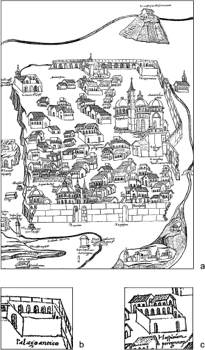
Fifteenth century Jerusalem according to the Comminelli Map (adapted by the author).

If this supposition is right, we know at least one miniature which depicts the Palazo [sic] Antico at the northwestern corner of the city: The Comminelli Map (ill. 1a).Footnote 55 This map appeared in a Latin version of Ptolomeus' geographical treatise written in 1472 by Hugo Comminelli and illustrated by Petrus Massarius from Florence.
The Palazzo Antico (illus. 1b) is depicted in the map as contained inside the city, behind a surviving section of the destroyed walls. The building is portrayed in a similar way to that of the Hospicium Peregrinorum (illus. 1c), i.e., a single-storeyed quadrangular building consisting of an open courtyard enclosed by archways, accessed by a single gate facing south (in the case of the Hospicium at least by two). This schematic illustration leaves no doubt as to the architectural nature of the Palazzo Antico, suitable of the lodging functions mentioned by Mariano da Siena and Georges Lengherand. The main question raised by the illustration is the location of the building, clearly set inside the walls. But as we shall see, the wall track portrayed should be considered as representative, and merely schematic.Footnote 56
The following section will deal with archaeological and material evidence that, amongst others, might also help us in defining the khān's geographical position.
The Archaeological Evidence
“No trace of the caravanserai has been found except for an inscription, now in the Islamic Museum on the Ḥaram.”Footnote 57
In this way M. Burgoyne summarised the archaeological information related to Baybars's khān in Jerusalem in the book Mamlūk Jerusalem which was published in 1987. Notwithstanding this short statement, the following paragraphs will discuss a wider range of direct and indirect evidence.
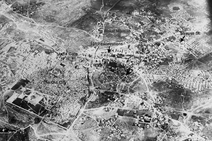
The first archaeological report to discuss the location of Khān al-Ẓāhir was that by F.M. Abel, excavating at the north-western corner of the walls of Jerusalem in 1912.Footnote 58 According to Abel, the excavations revealed a monumental gate with two building stages: the first being dated to the twelfth century and attributed to the Franks, the second being identified as Khān al-Ẓāhir. To support his identification, Abel quoted from Mujīr al-Dīn: “la construction du khân situé en dehors de Qouds l'illustre, au flanc nord-ouest et connu sous le nom de khân ed-Dâher”.Footnote 59 Abel assumed that by writing “min jihati al-gharbī ilā ‘l-shimālī,” Mujīr al-Dīn was referring to a structure in the immediate proximity, or even abutting the north-western side of the city. Nevertheless, the term “jiha”, amongst others, also means “direction”: Mujīr al-Dīn himself used the term to refer both to the Monastery of the Cross, some 2 km south-west from the city, and to Birkat Māmillā, ca. 250 meters west of Jaffa Gate.Footnote 60 Thence Abel's main premise for identifying the excavated gate as belonging to Khān al-Ẓāhir is weak.Footnote 61 In addition, it has been shown that the gate under discussion was part of the Crusader/Ayyubid wall and functioned as its postern.Footnote 62
˓Ārif al-˓Ārif, in his Al-Mufaṣṣal fī Ta'rīkh al-Quds from 1961, stated that the khān still existed at the street-junction inside the Damascus Gate, some 100m to the south of it. According to ˓Ārif al-˓Ārif, the building had four domes, “built in the Mamluk architectural style”. According to his testimony, the families al-Khālidī, al-˓Alamī, Qlaybū and others enjoyed from its [waqf] benefits. Such a proposition, nevertheless, lacks palpable evidence.Footnote 63
Al-˓Asalī's book on Islamic sites in Jerusalem from 1982Footnote 64 also presents a summary on Baybars’ khān. Apart from ˓Ārif al-˓Ārif 's argument, al-˓Asalī also brings forward information drawn from ˓Ali Sa˓īd Khalaf 's book Shay' min Ta'rīkhinā, published in 1979.Footnote 65 Khalaf located Khān al-Ẓāhir at the site of today's Central Bus Station on Jaffa Road in west Jerusalem, stating, with a surprising conviction, that the khān was two or three km north-west of the current city-walls.Footnote 66 Al-˓Asalī also referred to the 1912 French excavations, but dismissed Abel's conclusions on the basis of the archaeological evidence exposed by Bahat and Ben-Ari in 1971–1972 at “Tancred's Tower” in Ẓahal Square.Footnote 67
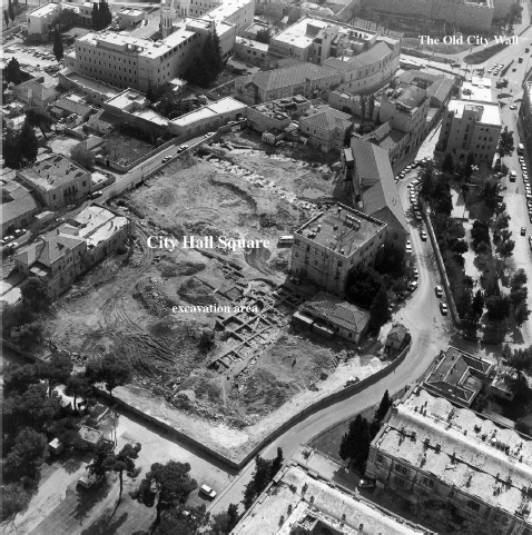
City Hall Square. From Maeir and Bahat, Kikkar Safra. Courtesy of Israel Antiquities Authority.

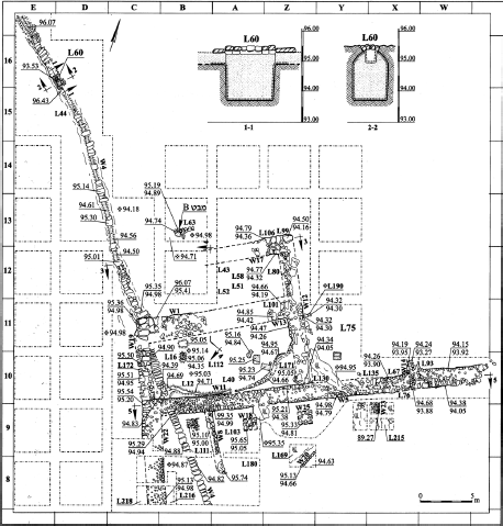
City Hall Square, plan of excavations. From Maeir and Bahat, Kikkar Safra. Courtesy of Israel Antiquities Authority.

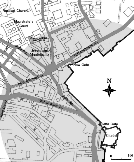
In 1989 Aren M. Maeir and Dan Bahat conducted salvage excavations at the City Hall Square in Jerusalem, south of the Russian Compound, to the north-west of the city wall's corner (ill. 2a).Footnote 68 During their excavations, Maeir and Bahat uncovered a “large medieval building complex” (ill. 2b) in a poor state of preservation, apparently previously excavated by Wilson in the 1860s.Footnote 69 Of this building, whose dimensions could not be determined, two portions were revealed: the northwestern corner of a courtyard, and a northern extension comprising of two rooms.Footnote 70 In addition, a water channel, pre-dating or contemporary with the building, was also uncovered. This channel, unrelated to the Māmillā Channel, carried rainwater (or spring water?) to the north-western corner of the city, and seems to be related to the channel revealed during the excavations at Tancred's Tower in 1971–1972.Footnote 71 As for the dating of the building, the evidence could not determine if it was erected during the Crusader period or later. The fragmentary architectural remains and stratified evidence, and mostly the few remains of floors, posed difficulties on interpreting the nature of the fills uncovered, mainly those containing Crusader-Ayyubid pottery. If contemporary with the building, it would imply a Crusader date for the structure, hence the preliminary identification of the site as the leper's hospital of the Order of St Lazarus.Footnote 72 In their final report this identification was revised, and a later Ayyubid-Mamluk date for the fill, and consequently for the building, was preferred.Footnote 73 Despite the vague evidence, and mostly influenced by the written information drawn from Mujīr al-Dīn, al-Maqrīzī, as well as from Joannes Cotovicus (1598–1599),Footnote 74 Maeir and Bahat concluded that the building in question should be identified as Khān al-Ẓāhir.Footnote 75
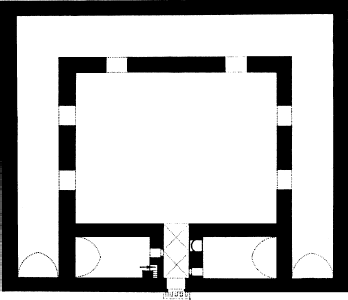
Unfortunately, little has remained of the excavated building to allow its reconstruction. Nevertheless, Khān al-Ẓāhir most probably followed the architectural example of the various Syrian khāns built during the Ayyubid and Early Mamluk periods.Footnote 76 Ibn Shaddād's description of “elevated structures in each of its sides” suits the standard plan of barrel-vaulted halls enclosing an open courtyard, entered through a single gate, facing one of the cardinal points, as in Khān ˓Ayyāsh in Syria, for example (690/1291; ill. 3).Footnote 77 These inns were usually provided with a prayer room; Ibn Shaddād's description, and Mujīr al-Dīn's after him, leave no doubt that that was the case in Jerusalem as well.Footnote 78 To the mill, oven and garden described by Ibn Shaddād, we can add a nearby water source or reservoir, essential for the functioning of a public khān. And as we know that a keeper, a cobbler, a farrier, as well as an imām, were permanent figures at this foundation, we can also reconstruct at least one private cell for them to dwell and store their goods.
Ground plan of Khān ˓Ayyāsh, Syria. After Sauvaget, Caravansérails Mamelouks.

A further architectural feature of this khān, drawn exclusively from the sources, is its gate, the Cairene Bāb al-˓Īd. Unfortunately, the various passages do not specify if they refer to the gate's façade or part thereof (such as a decorative arch), or only to its doors.Footnote 79 When in the fifteenth century al-Maqrīzī described four of the gates of the Greater (eastern) Fāṭimid Palace in Cairo,Footnote 80 Bāb al-˓Īd was still extant. He also added that Baybars had this very gate transferred to his khān in Jerusalem (wa-naqala ilayhi Bāb al-˓Īd hādhā). But as al-Maqrīzī solely described its vaulted interior and its domed superstructure, we do not know if by his time this gate in Cairo was missing its original façade, its original doors (wooden doors?),Footnote 81 or both.
As for the typical accompanying inscriptions and emblems found in Mamluk buildings, see the evidence brought forward in the next section.
The Epigraphic and Emblematic Evidence
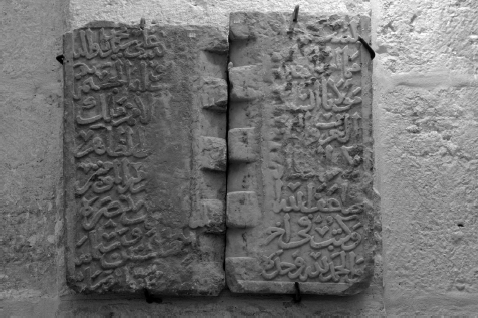
In addition to the above attempts to locate the site of Baybars' khān, discussion has also focused on few finds likely to originate from this building: two fragmentary inscriptions and two pairs of carved lions.Footnote 82
Inscription no. 1. Photo by David Silverman.

Under the definition “XXV (Pl. XVIII B). Construction of a Khān (?) by Sultan Baybars” M. Burgoyne and A. Abul-HajjFootnote 83 presented a fragmentary inscription, sectioned into two fragments (0.55 × 0.28 m and 0.53 × 0.31 m), found during the restoration of the Dome of the Rock in the 1960s and today exhibited at the al-Ḥaram al-Sharīf Islamic Museum in Jerusalem (illus. 4).Footnote 84 The two fragments had been used in the cornice on the outer face of the drum, and both the molding and the remains of mortar attest to that kind of use. The inscription itself was a secondary use of a marble column base, making its “recycling” as a cornice a “tertiary use”. Its translation reads:Footnote 85
1. In the name of G[od, the Compassionate, the Merciful. . ..] God bless our Lord Muḥammad and His family
2. [This is the blessed caravanserai] ordered to be founded by [- - - -] and . . .. . ..Footnote 86
3. His Majesty, the [August] Sul[ṭān - - - - Sovereign of the Heads] of Nations, King
4. of the Arabs and the Persians [and the Turks - - - - al-Ma]lik al-Ẓāhir
5. Rukn al-Dunyā wa'l-D[īn, Abū ‘l-Fatḥ Baybars al-Ṣāliḥī - - - - Associ]ate of the Commander of the Faithful
6. May God double his p[ower - - - -] and may his victory be glorious.
7. Written at the end of [- - - - the year] 662 (1263/1264).
8. Praise be to God Alone [- - - -] and [His] family and grant them salvation.
Three issues brought forward by the above inscription should be emphasised: first, its nature as a foundation inscription, made clear by the words “amara bi-inshā’. . .” in the second line; second, the naming of its patron as disclosed in lines three to five, and “al-Ẓāhir” in line four clarifying that this is a foundation by Baybars; finally, the dating of the foundation to year 662, as it appears in line seven, which links the inscription to the several written sources previously mentioned.
So even though the inscription was found out of context, and despite the fact it does not clearly define the nature of the building involved, this is very palpable evidence. Of course we should not forget that various sources do refer to works done by Baybars at al-Aqṣā (see above). The finding of the two inscribed fragments at the Dome of the Rock could also hint to a nearby work. On the other hand, it is still very tempting to relate this epigraphic evidence to the khān under discussion.
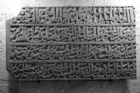
The second inscription (illus. 5), unfortunately also fragmentary, was included by Ḥamdān ˓Abd al-Rāziq Ḥusayn Manṣūr, in his Masters thesis (Dirāsa li'l-Nuqūsh al-˓Arabiyya fī al-Matḥaf al-Islāmī bi'l-Quds) dealing with the inscriptions found at the Islamic Museum at the Ḥaram al-Sharīf.Footnote 87 The inscription, registered as 14/M/S, can be found in the eastern wing of the museum and recorded as of unknown provenance. In fact, the inscription had been already published by van Berchem, in his section on the epigraphic material found at the al-Aqṣā mosque. Van Berchem did not identify it as belonging to Baybars' khān, and even suggested an early fourteenth century date following its epigraphic style.Footnote 88
Inscription no. 2. Photo by David Silverman.

Both from its physical appearance and from its meaning, van Berchem, and later Manṣūr, concluded that the text consists of the second half (0.75 × 0.43 m) of a longer inscription, the beginning of which is on a missing slab. Its translation reads:Footnote 89
1. . . .this blessed khān, 14 qīrāṭ of the totality of the landed estate. . .
2. . . .of the districts (a˓māl) of Buṣra; and the second share: half of Liftā, one of Jerusalem's villages (ḍayā˓). . .
3. . . . three ashum, and a third of a sahm, and a third of the eighth of a tenth sahm of twenty four sahm. . .Footnote 90
4. . . . in order to feed the comers, the poor and the miserable, may God accept it from him, and double his merits.
The Lions' Gate. Photo by David Silverman.

The above text is a portion of the waqf endowed to cover the expenses of a khān. Different from the previous inscription, it does not disclose the patron behind it, neither its date. Notwithstanding these blanks in information, the proximity in content to the data drawn from the sources (see above) on the lands endowed for the maintenance of Khān al-Ẓāhir, one concludes that we are clearly dealing with a remain from Baybars' khān.
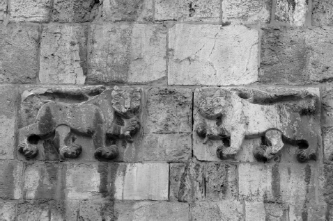
Finally, we should consider the two pairs of carved felines heralding the façade of St Stephen's Gate (The Lions' Gate; illus. 6) on the eastern side of the city wall. Both van Berchem and Creswell believed that they are in secondary use at that place,Footnote 91 following the Ottoman renovations of the city walls between 1537/38–1540/41. By identifying them as the heraldic symbol of Sultan Baybars, and considering that there is no knowledge of repairs being made to the city walls during his reign, it might be assumed that they belonged to his khān, the only building he erected in Jerusalem. In addition, van Berchem's opinion that the facing “fauves” most probably originally flanked an inscription (cf. Jisr Jindās at Lydda),Footnote 92 is strengthened by the finding of the two inscriptions discussed above.
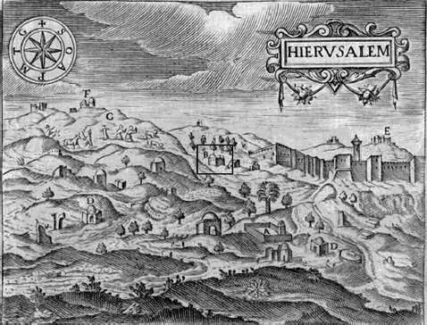
View of Jerusalem's walls and surroundings, as illustrated in J. Zuallart's II devotissimo viaggio di Gerusalemme (1587). According to the key: A- Piscina de Salomon, B- Mezquita de Turcos, C- Peregrinos, D- Sepulcros de Turcos, E- Monte Olivete, F- Silo.

Map of the north-western corner of the Old City of Jerusalem and surrounding area. Boundary of shaded area marks the ca. 500 m distance suggested in Mariano da Siena's account.

Aerial photograph of Jerusalem, April 21, 1918. Photo courtesy, Israel Government Press Office (adapted by the author).

The study of these two sets of felines becomes even more relevant in the framework of the present discussion once we read a passage by the pilgrim Jean Zuallart from 1586: “. . .alle due bande della quale [porta di S. Stefano], contra la lege de Turchi, sono sculpiti duo lioni che si reguardano l'un l'altro; & è il mede[si]mo sopra l'entrata d'una Moschea, dall altra banda della Cittagrave, della quale e fatta mentione dove habbiamo parlato della nostra venuta”.Footnote 93 Van Berchem suggested that the abovementioned mosque should be identified with the building marked B in one of the engravings illustrating the itinerary (illus. 7).Footnote 94 He writes: “C'est probablement celle qu'on voit en B dans sa gravure, au nord de la porte de Jaffa, et qui pourrait bien être ce même khān de Baibars, que le pèlerin flamand aurait pris pour une mosquée. . .”.Footnote 95
Of course one wonders how could the builders of the ‘Lions' Gate’ have used the carved felines from the abovementioned structure, if Zuallart saw them in situ almost fifty years later. Could Zuallart's lioni have been additional carvings, left untouched by the builders? Or were they inserted at the Ottoman gate in a later date?Footnote 96
Is it possible that by this “archaeological” approach to a sixteenth century western source, van Berchem had already solved the “location-enigma” of Baybars' khān as early as in 1922?
Conclusion
The research on Khān al-Ẓāhir is a good example of the potential of an integrated archaeological-historical work. This is one of the few occasions in which so much is known about a building by Baybars in Palestine – the date of its foundation, its related waqf, the purpose of the building, the functions attached, etc. – while little archaeological evidence has so far been indisputably associated with this khān. On the other hand, the combination of the data available allows us to learn a fair amount of details, and even to attempt a reconstruction of its physical characteristics.
As for the unsettled question – “where was the khān?” – we should try to answer it by ruling certain areas out, mainly because they are not in Māmillā as clearly indicated by Ibn Kathīr and indirectly by Mujīr al-Dīn. While Tancred's Tower has been already dismissed, the Central Bus Station is far Māmillā. The Damascus Gate should be also ruled out, at as it is at the northern side of the city, and not at the north-western as stated by Mujīr al-Dīn. On the other hand, and despite the vague material finds from Maeir and Bahat's excavations, Kikkar Safra (illus. 2, 9) seems to fit all criteria: it is at the north-western side of the city, as well as in the main water line providing Jerusalem with water from Hebron. It is also near Birkat Māmillā, even though the excavations did not uncover any connections to this specific water source. Indirectly, it also defines some of the north-eastern extension of Māmillā during the Mamluk period. It corresponds to the region where Zuallart's “mosque” is located, and could well suit Mariano da Siena's estimation of one “balestrata” distance,Footnote 97bi-ẓāhir al-Quds!