The initial colonization of the Americas by the ancestors of the continents’ indigenous peoples has long been a compelling topic of scientific investigation. Over the last 20 years, archaeologists working on the question of how and when people first arrived on the continents of North and South America have demonstrated the plausibility of an initial entry from Asia along the North Pacific Rim (Erlandson et al. Reference Erlandson, Graham, Bourque, Corbett, Estes and Steneck2007; Goebel et al. Reference Goebel, Waters and O'Rourke2008; Madsen Reference Madsen2015). New research indicates that the ice-free corridor was not biologically viable for human migration until 12,600 cal B.P. (Mandryk et al. Reference Mandryk, Josenhans, Fedje and Mathewes2001; Pedersen et al. Reference Pedersen, Ruter, Schweger, Friebe, Staff, Kjeldsen, Mendoza, Beaudoin, Zutter, Larsen, Potter, Nielsen, Rainville, Orlando, Meltzer, Kjaer and Willerslev2016), which shifts greater weight to the hypothesis that the initial human entry into the Americas followed a Pacific coastal route. The early archaeological record from Pacific Rim coastal zones shows that humans made use of marine ecosystems by at least 25,000 B.P. in the western Pacific (Buvit et al. Reference Buvit, Izuho, Terry, Shitaoka, Soda and Knikita2014; Fujita et al. Reference Fujita, Yamasaki, Katagiri, Oshiro, Sano, Kurozumi, Sugawara, Kunikita, Matsuzaki, Kano, Okumura, Sone, Fujita, Kobayashi, Naruse, Kondo, Matsu'ura, Suwa and Kaifu2016; Kuzmin et al. Reference Kuzmin, Vasilevsky, O'Malley and Timothy Jull1998; Matsu'ura and Kondo Reference Matsu'ura and Kondo2011; Takamiya and Obata Reference Takamiya and Obata2002) and 10,600 B.P. along the northwest coast of North America (Fedje et al. Reference Fedje, Mackie, Lacourse and McLaren2011). In addition, people likely occupied older shorelines now submerged beneath rising postglacial sea levels (Davis Reference Davis, Bicho, Haws and Davis2011; Davis et al. Reference Davis, Jenevein, Punke, Noller, Jones, Willis, O'Connor, Dorsey and Madin2009; Gusick and Davis Reference Gusick and Davis2010; Mackie et al. Reference Mackie, Davis, Fedje, McLaren, Gusick, Graf, Ketron and Waters2013; Reeder-Myers et al. Reference Reeder-Myers, Erlandson, Muhs and Rick2015; Westley and Dix Reference Westley and Dix2006). While the North American record signals the presence of early humans along the northeastern Pacific coast by the Late Pleistocene, we know much less about the technological systems employed by these peoples. So far, the artifacts and fauna from North America's Late Pleistocene to early Holocene–aged Pacific coastal sites show an emphasis on littoral and nearshore kelp ecosystems. This is intriguing, particularly considering that Late Pleistocene adaptations to marine ecosystems, such as those along the western Pacific Rim, indicate the use of offshore, deep-sea fishing technologies (Fujita et al. Reference Fujita, Yamasaki, Katagiri, Oshiro, Sano, Kurozumi, Sugawara, Kunikita, Matsuzaki, Kano, Okumura, Sone, Fujita, Kobayashi, Naruse, Kondo, Matsu'ura, Suwa and Kaifu2016; O'Connor et al. Reference O'Connor, Ono and Clarkson2011; Smith and Allen Reference Smith, Allen, Hall and McNiven1999).
Globally, the earliest evidence for the use of marine shell to manufacture fishhooks comes from Sakitari Cave on Okinawa, Japan (22,770–22,380 B.P.; Fujita et al. Reference Fujita, Yamasaki, Katagiri, Oshiro, Sano, Kurozumi, Sugawara, Kunikita, Matsuzaki, Kano, Okumura, Sone, Fujita, Kobayashi, Naruse, Kondo, Matsu'ura, Suwa and Kaifu2016), Jerimalai Shelter, (19,952 ± 235–13,658 ± 91 B.P.; O'Connor et al. Reference O'Connor, Ono and Clarkson2011) and Lene Hara Cave (9741 ± 60 B.P.; O'Connor and Veth Reference O'Connor and Veth2005). Additionally, finds of similar hooks on New Ireland dating to between 20,000 and 18,000 B.P. have also been reported (Smith and Allen Reference Smith, Allen, Hall and McNiven1999). Other early shell fishhooks come from Hayonim Cave B, Israel (14,150 ± 140–11,570 ± 75 B.P.; Bar-Yosef Mayer and Zohar Reference Bar-Yosef Mayer and Zohar2009; Weinstein-Evron et al. Reference Weinstein-Evron, Yeshurun, Kaufman, Eckmeier and Boaretto2012). The presence of fishhooks and the remains of deepwater fish species in archaeological sites provide evidence that prehistoric humans exploited offshore environments beyond tidal pools, surf, and nearshore zones, using watercraft capable of traveling significant distances from the shore to access deeper marine habitats (e.g., Davidson and Leach Reference Davidson, Leach, Clark, Leach and O'Connor2008; Steadman and Jones Reference Steadman David and Jones2006). These discoveries demonstrate the existence of a toolkit focused on aquatic resources along much of the western Pacific Rim during the millennia prior to the dispersal of human populations into the Americas. However, technologies specifically designed to harvest marine resources from beyond the intertidal and/or surf zones have yet to be documented archaeologically in the Americas during time frames relevant to the question of initial peopling.
In the Americas, scholars have long held that single-piece shell fishhooks were employed to recover deepwater fish species only after the middle Holocene (Erlandson et al. Reference Erlandson, Rick and Braje2009). Bipointed items of bone interpreted as possible fishing gorges have been 14C dated to the early Holocene at the Daisy Cave site on San Miguel Island, California, but these cannot be clearly linked to deepwater, offshore fishing for pelagic species (Rick et al. Reference Rick, Erlandson and Vellanoweth2001). Currently, the earliest shell fishhooks from the Pacific coast of South America are from sites in Chile and Peru. At the Quiani site in northern coastal Chile, shell fishhooks date to 6170 ± 220 B.P. (Mostny Reference Mostny1964), and although the site likely contains older examples, none have been dated by 14C. At the sites of Zapatero and Morro Colorado in northern Chile, hooks of similar manufacture made on mussel (Choromytilus chorus) shell are associated with charcoal dates of 7470 ± 30 and 6490 ± 40 B.P., respectively (Flores et al. Reference Flores, Figueroa and Salazar2016:414). It may be significant that Espíritu Santo Island, off Baja California Sur, Mexico, has also produced very early shell fishhooks. Fujita (Reference Fujita2014) reports a fishhook preform directly dated to 8380 ± 50 B.P. from well-preserved strata in the cave site of Covacha Babisuri. Elsewhere on the island, coauthor Davis has discovered multiple early Holocene–aged shell hooks from the Mesa Ballena site complex (personal communication 2017).
The earliest single-piece shell hooks in the Alta California archaeological record date to 2980 ± 35 B.P. (Rick et al. Reference Rick, Vellanoweth, Erlandson and Kennett2002:937). The absence of single-piece shell hooks in early North American Pacific coastal sites raises questions about whether the exploitation of resources beyond littoral and nearshore zones was delayed because of environmental instability caused by postglacial marine transgression, or whether fishing techniques employing shell hooks were developed only in response to a demographically driven need to intensify offshore fishing during the middle to late Holocene (e.g., Rick Reference Rick2007).
Compared to Pleistocene-aged coastal sites from other parts of the world, the early archaeological record of North America's Pacific coast might mean that the first indigenous peoples of the Americas lacked a full mastery of the ocean and were thus compelled to cleave tightly to its terrestrial margins for survival. If they were so well adapted to a marine environment, the argument goes, where are the tools that should be the residue of such a focus? Where were the nets, the hooks, and the specialized technology? If they were not preadapted to a maritime way of life, how could they disperse so rapidly along an unforgiving and rapidly changing Late Pleistocene coastal environment (Westley and Dix Reference Westley and Dix2006)?
We now can report that archaeological excavations conducted on Cedros Island, Baja California, Mexico, during 2008 and 2009 recovered two complete single-piece shell fishhooks, a shell fishhook shank fragment, and an unfinished hook from two stratified archaeological sites (Des Lauriers Reference Des Lauriers2010, Reference Des Lauriers, Bicho, Haws and Davis2011) associated with radiocarbon ages ranging between 10,420 and 8900 B.P. This is the earliest definitive evidence for fishhook manufacture in the New World. These artifacts were associated with fish remains that include offshore, deepwater species, indicating a more expansive adaptation to the Pacific Ocean than previously known. Here we describe the geoarchaeological context and archaeological contents of these sites, and discuss how they change our views of early maritime adaptation in the Americas.
Cedros Island and Investigated Sites
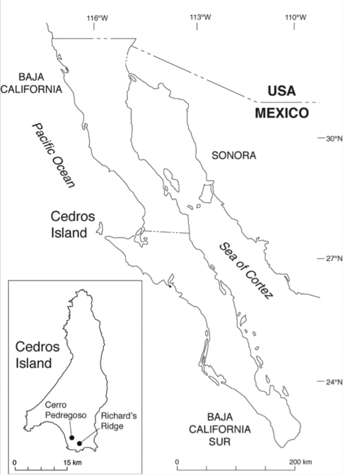
Cedros Island is an arid, rocky island located at the midpoint of the Pacific coast of the Baja California Peninsula in northwest Mexico (Figure 1). It reaches a maximum altitude of 1,350 m asl, measures 35 km north-south, and has a maximum width of 16 km, although the average width is closer to 7 km. The persistence of numerous freshwater springs and seeps up to the present day is something of a hydrological puzzle, as most of the islands of the Baja California Peninsula lack abundant permanent water sources. This feature allowed permanent occupation of the island in the past, including large villages encountered by the earliest Spanish explorers (see Mathes Reference Mathes1968, Reference Mathes and Mathes1990; Montané-Martí Reference Montané-Martí1995). Today the island supports a sizable town (~2,000 residents) whose primary water source is a large spring complex improved with tanks and a pumping station located high on the largest peak of the island. The landscape is extremely arid, with Colorado Desert flora at sea level giving way to juniper (Juniperus sp.) and manzanita (Arctostaphylos sp.) at mid-elevations, and a thin corona of pine (Pinus sp.) forest stands along the crests of the highest west-facing slopes. The primary source of water for this vegetation is condensation from marine layer fog, which is so characteristic of the island that the indigenous name of the island was Huamalgua, the Island of Fogs (Venegas Reference Venegas and Mathes1979). Although none of the island's original inhabitants remain, early eighteenth-century Jesuit documents provide a wealth of ethnohistoric data (Des Lauriers and García-Des Lauriers Reference Des Lauriers and García-Des Lauriers2006). While the Baja California Peninsula is less studied than other regions of the New World, the last 20 years have seen an upswing in scholarly and salvage work by Mexican and American archaeologists (see Laylander and Moore Reference Laylander and Moore2006).
Location of Cedros Island, Baja California, Mexico. Inset: Location of sites containing single-piece shell fishhooks.

Prior to ca. 14,500 cal B.P., Isla Cedros may have been briefly connected to the peninsular mainland at Punta Eugenia by a low-lying, possibly tidally exposed, narrow land bridge. By 10,000 cal B.P., marine transgression had both severed this connection and formed two small bays at the island's southeastern headland. With continued sea level rise, the island approximated its modern form by ca. 8000 cal B.P. The island contains a well-preserved archaeological record that spans nearly the entire scope of human occupation in the Americas. Current evidence suggests an initial occupation prior to 13,000 cal B.P. The Proyecto Arqueológico Isla de Cedros, under the auspices of the Instituto Nacional de Antropología de México and directed by author Des Lauriers, has investigated several of the deposits dating to the earliest phases of occupation. Among these sites, two were excavated during 2008–2009: Cerro Pedregoso (PAIC-44) and Richard's Ridge (PAIC-49).
Geoarchaeological Context
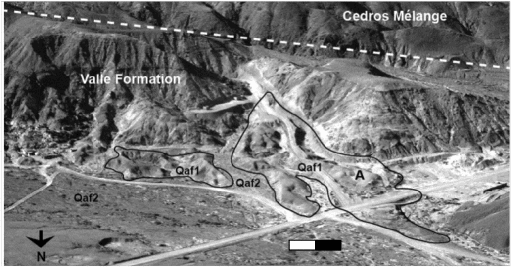
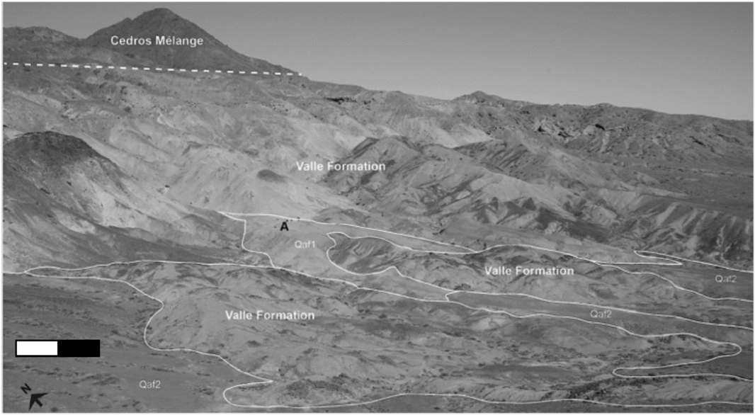
The bedrock geology of southwest Cedros Island includes two main units: the Cedros Mélange and the Valle Formation (Boles and Landis Reference Boles and Landis1984). The Cedros Mélange is a poorly sorted breccia, containing a wide variety of clastic rock lithologies held in an argillite matrix (Boles and Landis Reference Boles and Landis1984; Silver and Beutner Reference Silver and Beutner1980). The Valle Formation overlies the edges of the Cedros Mélange and is comprised of fine sedimentary deposits originating from the erosion of the Baja California Peninsula's granitic batholith and subsequent deposition into deepwater marine fans during the Middle to Late Cretaceous. The Cerro Pedregoso and the Richard's Ridge sites are seen on the surface of and within gently sloping portions of unconsolidated surficial geology units that flank the lower edges of the Valle Formation (Figures 2 and 3).
Oblique aerial view of the Cerro Pedregoso site (PAIC-44) locality, Cedros Island, showing local bedrock units and surficial geology deposits. Excavations conducted in 2008–2009 were positioned at A. In this locality, the Qaf1 map unit denotes alluvial fans that contain early Holocene–aged archaeological components. Qaf2 alluvial fans are hypothesized to be younger than Qaf1.

Oblique overview of the Richard's Ridge site (PAIC-49) locality, Cedros Island, showing local bedrock units and surficial geology deposits. Excavations conducted in 2008–2009 were positioned at A. In this locality, the Qaf1 map unit denotes alluvial fans that contain late Pleistocene to early Holocene–aged archaeological components. Qaf2 is hypothesized to be of younger Holocene age than Qaf1.

Lithostratigraphy and Lithofacies
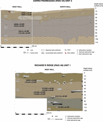
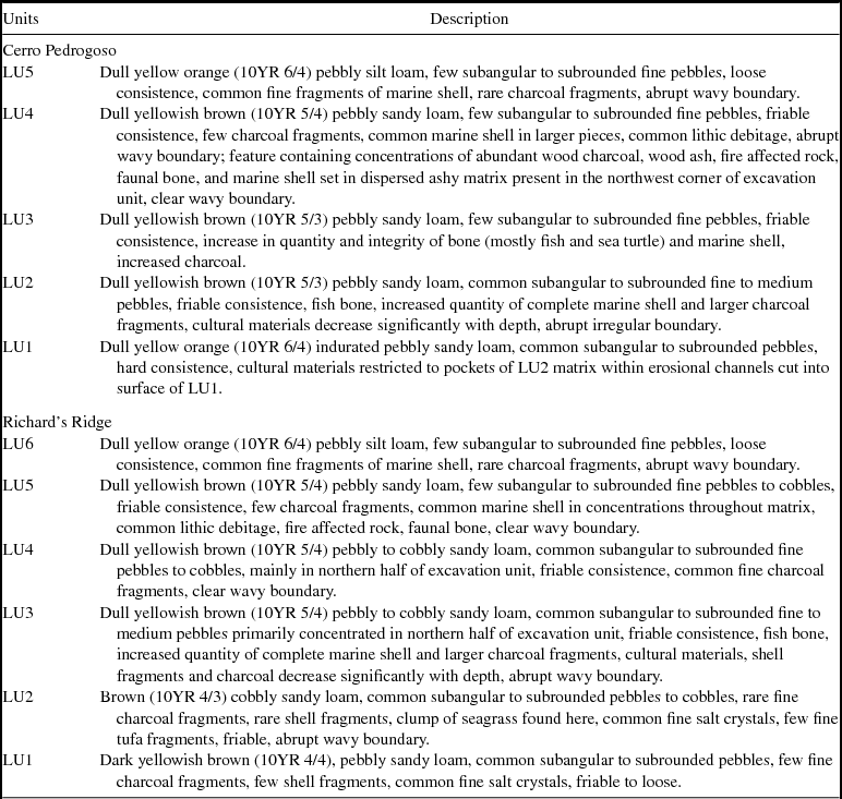
Descriptions of lithostratigraphic units (LU) were made from field observations in accordance with methods and nomenclature described by Birkeland (Reference Birkeland1984), the North American Stratigraphic Code (NACOSN 1983), and the U.S. Soil Survey (1993). Both sites contain well-stratified, horizontally bedded depositional sequences comprised of sand- and silt-dominated sediments (Figure 4, Table 1) that contained scattered fragments and whole pieces of marine shell, lithic artifacts, and intact concentrations of ashy sediment. At the base of each profile, we encountered indurated deposits that did not yield cultural materials. Above this indurated basal deposit, each site contains a series of pebbly sandy loam deposits that were ultimately capped by a thin layer of pebbly silt loam. The presence of abrupt wavy and irregular boundaries between several units (e.g., LU2-LU1, LU3-LU2, LU4-LU3 at Cerro Pedregoso) suggests some amount of erosion occurred between the timing of new deposition. In general, lithostratigraphic units at both sites retained a 1–2° dip away from nearby bedrock formations and parallel to the long axis of their associated surficial geology landform. The subangular to subrounded nature of the pebble clasts suggests an alluvial or marine origin (i.e., eroded and redeposited from upland Cedros Mélange breccia units). Taken in combination, both sites are contained within what is interpreted as remnant alluvial fan deposits that accumulated at the mouth of small tributary drainages that incised into and redeposited geologic materials from the adjacent Valle Formation sedimentary deposits and Cedros Mélange breccias.
Representative stratigraphic profiles from Cerro Pedregoso and Richard's Ridge sites, Cedros Island, showing lithostratigraphic units and radiocarbon dated samples.

Lithostratigraphic Units at Cerro Pedrogoso and Richard's Ridge.

Chronometric Dating Methods and Sample Materials
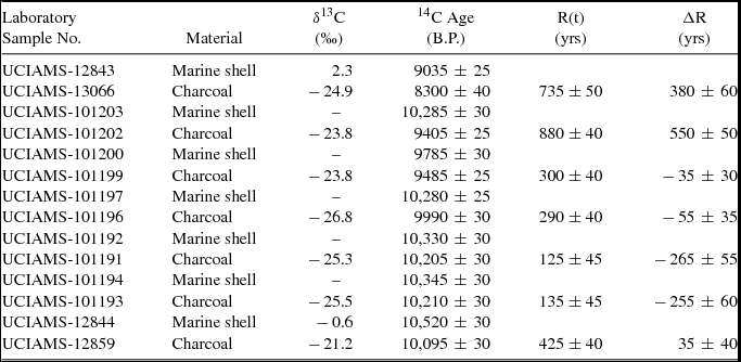
We selected marine shells and wood charcoal recovered in situ during excavations for radiocarbon analysis. Marine shell samples were etched in 0.5N HCl to remove 25 to 50 percent by weight of the physically cleaned shell, and aliquots of 10–12 mg of pretreated shell were hydrolyzed under vacuum with 80 percent phosphoric acid in sterile Vacutainer™ tubes to evolve the sample CO2. Charcoal samples underwent successive treatments at 70°C with 1N HCl, 1N NaOH (repeated as necessary), 1N HCl, and Milli-Q™ H2O, and dried samples (~1 mg) were combusted in vacuo with CuO and Ag in sealed quartz tubes for three hours at 900°C. CO2 evolved from acidification or combustion was reduced to graphite using H2 in the presence of an Fe catalyst. This material was then pressed into target cathodes for insertion into the ion source of the AMS spectrometer at the University of California, Irvine. Unknown age samples were measured along with background samples of infinite 14C age, modern reference standards, and known age secondary standards. The δ13C values listed in Table 2 were obtained on a Delta-Plus isotope ratio mass spectrometer interfaced with a Gasbench II. Calibrated ages were obtained with CALIB 7.1 (Stuiver et al. Reference Stuiver, Reimer and Reimer1993) using the IntCal13 and Marine13 data sets (Reimer et al. Reference Reimer, Bard, Bayliss, Warren Beck, Blackwell, Ramsey, Buck, Cheng, Lawrence Edwards, Friedrich, Grootes, Guilderson, Haflidason, Hajdas, Hatté, Heaton, Hoffmann, Hogg, Hughen, Felix Kaiser, Kromer, Manning, Niu, Reimer, Richards, Marian Scott, Southon, Staff, Turney and van der Plicht2013), and a calculated ΔR value of 150 ± 400 14C years for marine samples. Calibrated age ranges are quoted at 2σ and rounded to nearest 5-year increment. For UCIAMS-64251 in Table 2, the 2σ ranges for multiple intercepts representing relative areas under the probability distribution of p ≥ 0.05 are noted in parenthesis for intercept separations of ≥ 20 years.
Charcoal and Marine Shell Samples Used to Determine ΔR Uncertainty Values.

Note: Adapted from Taylor and Bar-Yosef Reference Taylor and Bar-Yosef2014:Table 5.6.
Cedros Island 14C Marine Reservoir Correction (ΔR): 8300–10,095 B.P.
On average, carbonates in surface ocean waters are depleted in 14C content relative to atmospheric values by about 5 percent or 400 years (Stuiver and Braziunas Reference Stuiver and Braziunas1993); however, 14C reservoir offsets measured in the shells of coastal marine mollusks exhibit significant spatial variability (Berger et al. Reference Berger, Taylor and Libby1966). Reservoir corrections also vary significantly over time in some coastal zones, including that of Cedros Island (Taylor et al. Reference Taylor, Southon and Des Lauriers2007). Ideally, reservoir offset values should be calculated based on measurements of control samples collected from the same oceanic regime of the dated samples. These variable offsets reflect changes in the rates of upwelling of water parcels in which the dissolved inorganic carbon (DIC) has been depleted in 14C content by long residence times in deeper ocean layers. The coastal upwelling phenomenon is caused by wind energy moving parallel to a shoreline. This wind action combined with the Earth's rotation moves surface ocean water at right angles to the wind direction (Coriolis Effect), and as surface water is driven offshore, 14C-depleted deeper water upwells and replaces it. The resulting 14C depletion of DIC in coastal surface waters is incorporated into the marine shell carbonate. Regional 14C marine reservoir corrections are expressed in terms of a calculated value (ΔR), which represents the difference in 14C years between the specific measured regional offset value (R[t]) and a global marine model age for a sample exhibiting that age (Stuiver and Braziunas Reference Stuiver and Braziunas1993). Thus, the overall correction combines the time-varying global marine-atmospheric 14C offset with an additional spatial component reflecting local or regional differences from the global marine average.
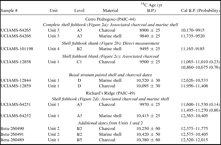
The marine reservoir corrections for the coastal region surrounding Cedros Island have varied significantly over the Holocene, consistent with the complexity of the local hydrography. The dominant oceanographic feature surrounding the island is the California Current, which represents the eastern boundary current of the North Pacific Gyre. The California Current, one of five major currents in the world associated with major coastal upwelling, consists of a southward surface current, a northward trending undercurrent, and surface countercurrents. In addition, the presence of the North Equatorial Counter Current and intricate eddy motions of ocean water masses in the region contribute to the complexity of the coastal upwelling regime (Miller et al. Reference Miller, McWilliams, Schneider, Allen, Barth, Beardsley, Chavez, Chereskin, Edwards, Haney, Kelly, Kindle, Ly, Moisan, Noble, Niiler, Oey, Schwing, Kipp Shearman and Swenson1999). Table 2 illustrates the variability in ΔR values for the relevant period, with calculated ΔR values ranging from −265 ± 60 to 550 ± 50 14C years from 10,210 ± 30 to 8300 ± 40 B.P. Based on these results, we adopted a conservative ΔR estimate of 150 ± 400 to calculate the reservoir corrected calibrated 14C ages for the archaeological marine shell samples listed in Table 3. Taylor et al. (Reference Taylor, Southon and Des Lauriers2007) provides specific details on the data and considerations entering into the calculation of ΔR value for the Cedros Island region for the relevant time period.
14C Measurements on Shell Fishhooks and Associated Charcoal and Marine Shell Samples.

Chronostratigraphy and Site Formation History
Radiocarbon ages on wood charcoal samples provide the basis for establishing a chronostratigraphic framework at the two sites. Excavations at Cerro Pedregoso in 2009 encountered deposits that contained charcoal ages spanning 9465–8850 B.P. (14C ages at 2σ), while the Richard's Ridge excavations in 2008 produced samples with charcoal ages spanning 10,500–9920 B.P. (at 2σ). Earlier investigations conducted by Des Lauriers (Reference Des Lauriers2010) produced a pair of radiocarbon ages from Cerro Pedregoso, excavation Unit 1, layer D (LU2), measuring 10,095 ± 30 (charcoal) and 10,520 ± 30 (Chione shell) B.P. (Table 3). The current radiocarbon chronologies at both sites overlap in time and span the period 10,500–8850 B.P. (including 2σ uncertainty).
Radiocarbon analysis reveals both sites accumulated sediments quickly, with 90 cm accumulating at Cerro Pedregoso in ca. 615 14C years and 120 cm at Richard's Ridge in ca. 580 years (based on stratigraphic profiles shown in Figure 4). Although the presence of abrupt and irregular boundaries separating several lithostratigraphic units suggests the operation of erosional processes at different points, radiocarbon analysis suggests little time is likely missing from the stratigraphic sequences of these sites. Indeed, the only significant temporal gap exists at Cerro Pedregoso, where the two-sigma error limits of radiocarbon samples on either side of the LU3–LU2 boundary are separated by 395 radiocarbon years. In all, the stratigraphic sequences of both sites appear largely conformable and record a sequence of rapidly aggrading sediments spanning the late Pleistocene to early Holocene.
Results of Excavations
Excavations at Cerro Pedregoso (PAIC-44) included a total of two 1 × 1 m units and three 1 × 2 m units, the former excavated in 2004 (Des Lauriers Reference Des Lauriers2010) and the latter excavated in 2009. These units were excavated to depths averaging slightly more than 1 m, sampling a little more than 8 m3 of deposit. Excavations conducted at Richard's Ridge in late 2008 included three 1 × 2 m units that varied significantly in depth. Unit 1 reached nearly 1.3 m below datum (elevations were taken from a level line tied to a datum pin placed in the highest corner of each excavation unit). Unit 2 encountered cultural deposits to nearly 1 m in depth, and Unit 3 was terminated at 40 cm below datum. Overall, units were excavated to an average depth of 0.9 m below datum at Richard's Ridge, sampling approximately 5.4 m3 of sediment. Deposits at both sites were excavated with trowel, brush, and dustpan using arbitrary 10 cm levels within strata, providing both volumetric control and natural stratigraphic separation of material. Sediments were screened through nested ¼-inch and ⅛-inch steel mesh. A 20 × 20 cm column sample of representative lithostratigraphic units was recovered from one wall of each excavation unit. Fragments of charcoal, shell, or bone identified in situ and deemed potentially valuable as radiocarbon samples were point plotted and recovered with an alcohol-sterilized trowel and immediately placed in aluminum foil packets. We recovered every in situ occurrence of paired shell and charcoal samples in order to calculate ΔR values. A total of 21 paired samples of small ring structure wood charcoal and marine shell from PAIC-44 and PAIC-49 were submitted for 14C dating and subsequently used in the determination of the ΔR values for this time period on Isla Cedros (see Des Lauriers Reference Des Lauriers2010; Taylor et al. Reference Taylor, Southon and Des Lauriers2007).
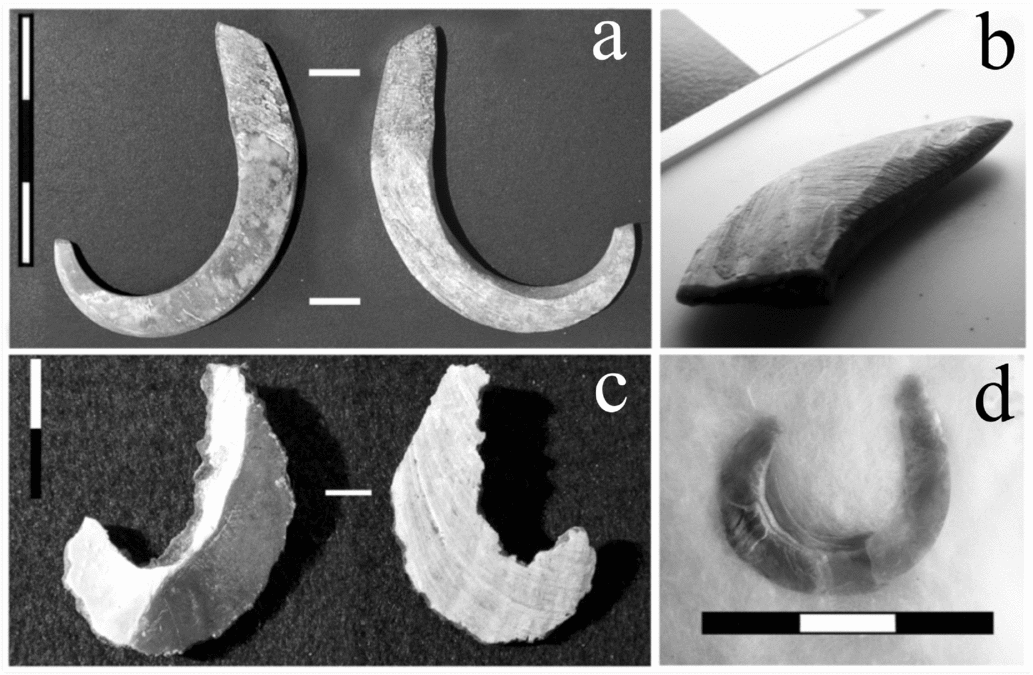
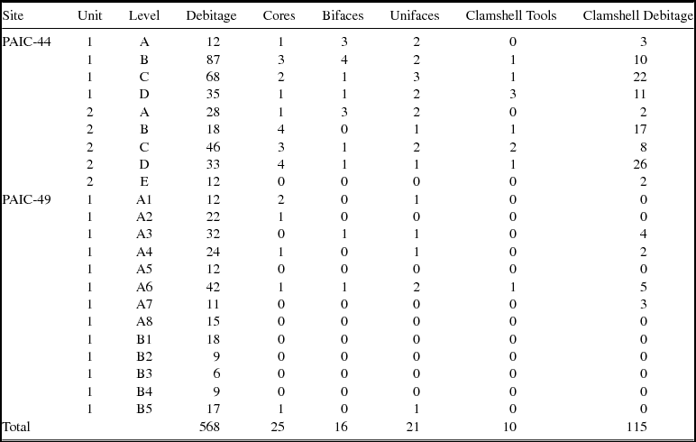
Excavations at the Richard's Ridge and Cerro Pedregoso sites (Figure 1) recovered numerous artifacts that we believe document the manufacture and use of single-piece shell fishhooks and the exploitation of a wide variety of marine resources from the terminal Pleistocene to early Holocene (Figure 5). Both sites produced rich lithic artifact assemblages that include numerous lithic bifaces, knives, projectile points, flake tools, a unifacial tool industry, and conchotechnic tools produced by flaking thick Tivela clamshell valves (Table 4). Microscopic analysis of the unifacially flaked stone tools from these sites revealed unifacial edge wear, consistent with agave processing for cordage manufacture (Elzinga Reference Elzinga2011). The projectile points range from small foliate points to larger shouldered stemmed varieties, including some asymmetrical hafted knifeblade forms. The debitage toolstone is dominated by metavolcanic stone and quartz, and lesser amounts of low-grade chert. Obsidian is entirely absent from all early deposits thus far excavated, and in general, higher quality toolstone local to the island occurs in very low quantities.
Late Pleistocene/early Holocene–aged single piece shell fishhooks recovered from excavations on Cedros Island, Baja California: (a) complete J-shaped shell fishhook; (b) shank fragment of a very similar hook; (c) unfinished shell hook of same size, configuration, material (Mytilus californianus), and manufacturing approach as (a) and (b); (d) hook of a more circular configuration made from abalone (Haliotis sp.) shell. (a), (b), and (c) from Cerro Pedregoso (PAIC-44), (d) from Richard's Ridge (PAIC-49).

Quantity and Distribution of Lithic and “Concholithic” Artifacts from Cerro Pedregoso (PAIC-44) and Richard's Ridge (PAIC-49).

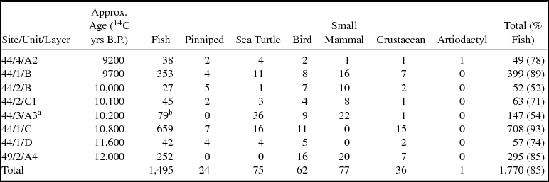
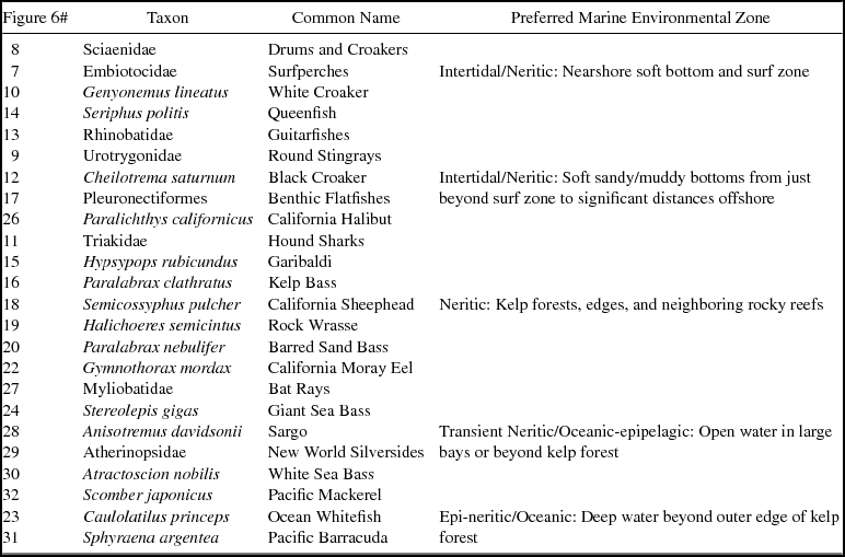
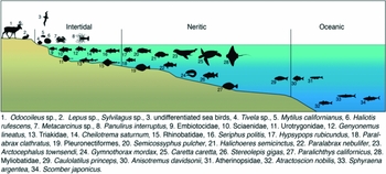
To date, the Cerro Pedregoso site contains the most diverse faunal assemblage of any archaeological locality on Cedros Island. This site has yielded thousands of fish remains belonging to 25 separate piscine taxa, accompanied by a wide range of mollusk, crustacean, pinniped, turtle, bird, lagomorph, and artiodactyl taxa (Tables 5 and 6; Figure 6). Other than mollusks, fish, and crustaceans, the most consistent faunal elements recovered are those of sea turtle and sea mammal. Despite demonstrating the presence of a pygmy form of mule deer (Odocoileus hemionus cedrosensis) on the island as far back as 12,000 cal B.P., only a handful of specimens have so far come from over 12 m3 of late Pleistocene/early Holocene–aged deposits at the two sites. This suggests a low level of human hunting pressure during the initial phase of colonization. Dating slightly earlier, the Richard's Ridge site contains comparable amounts of mollusk, fish, and crustacean remains, but fewer large bones of pinnipeds, sea turtles, or terrestrial fauna. To date, no artiodactyl remains have been recovered from Richard's Ridge, possibly indicating an even lower level of interest in terrestrial fauna earlier in time.
NISP from Selected Contexts at Cerro Pedregoso (PAIC-44) and Richard's Ridge (PAIC-49).

a This level produced the complete mussel shell fishhook.
b This NISP corrects a typographical error in Des Lauriers (Reference Des Lauriers2010).
Fish Remains from Terminal Pleistocene/Early Holocene Levels at Cerro Pedregoso and Their Respective Marine Environmental Zones.

Note: Number in left column corresponds to taxa label in Figure 6.
Fauna recovered from the Richard's Ridge and Cerro Pedregoso sites and their typical Cedros Island habitats.

One complete single-piece shell fishhook, one unfinished fishhook, and a fishhook shank fragment were recovered at Cerro Pedregoso. The complete fishhook (Figure 5a) was recovered in situ at 25 cm below datum from Level A3 of Unit 3 while the hook shank fragment (Figure 5b) was recovered while screening sediments from Level B2 of Unit 4. Both of these items were manufactured from thick mussel shell (Mytilus californianus) and are generally J-shaped in outline. In addition, a worked piece of mussel shell (Figure 5c) recovered in situ from Layer C of Unit 1 is clearly an unfinished fishhook of the same variety, demonstrating on-island manufacture. A third finished single-piece fishhook (Figure 5d) was recovered at the Richard's Ridge site from an in situ context in direct association with a shell and bone dump feature at 20 cm depth below datum. This artifact is a C-shaped, or circular, shell fishhook produced from what is most likely nacreous red abalone (cf. Haliotis ruescens) shell. The shell fishhook shank (Figure 5b) was directly 14C dated to 9495 ± 25 B.P. (UCIAMS-101198) with a calibrated 14C age of 11,165–9185 cal B.P. (at 2σ). Meanwhile, the other examples were dated by 14C measurements on stratigraphically associated charcoal and marine shell samples for the complete (Figure 5a) and unfinished shell fishhook (Figure 5c) from Cerro Pedregoso as well as charcoal and marine shell 14C values associated with the Richard's Ridge circular shell fishhook (Figure 5d) and range between 10,415 ± 25 B.P. and 8900 ± 25 B.P.
Discussion
Shell fishhooks are among the earliest specialized technologies on Cedros Island and were employed during a time of major changes in climatic, ecological, and coastal geomorphological systems (Fedje et al Reference Fedje, Mackie, Lacourse and McLaren2011; Mandryk et al. Reference Mandryk, Josenhans, Fedje and Mathewes2001; Westley and Dix Reference Westley and Dix2006). The lowest occupational layers at Richard's Ridge (PAIC-49) date to at least 12,000 cal B.P. (Des Lauriers Reference Des Lauriers2010) and contain similar icthyofaunal species profiles to those layers that contained shell fishhooks, raising the possibility that the technology was present even earlier than the particular artifacts recovered thus far suggest. Therefore, we hypothesize that Cedros Island shell hook and line fishing was neither dependent on more stable mid-Holocene coastlines, nor an innovative response enabling diet breadth expansion. Instead, our data indicate that hook and line technologies appear on Cedros Island at least by the Late Pleistocene and were employed alongside harpoons—as suggested by foliate bifacial projectile points and sea turtle and pinniped remains—and in conjunction with fishing nets probably made from agave fiber, which is further evidenced by abundant small fish vertebrae (Atherinopsidae).
During the late Pleistocene and early Holocene, Cedros Island's nearshore bathymetry lacked the steep topographic relief required for foragers to fish for deepwater species from shore. However, a deep marine trench reaching more than 1,500 m below modern sea level lay within 5 km west of the island before 10,000 cal B.P. Between 13,000–10,000 cal B.P. there was a vanishingly small number of locations where water deeper than 25 m was closer than 1 km to the paleoshoreline of the island; however, along the southern portion of the island, and in nearly all other areas, early foragers would have had to travel in boats more than 2 km offshore to find water of that depth.
The abundant remains of fish associated with shallow muddy or sandy substrate (e.g., Rhinobatidae), as well as fish (Atherinopsidae; Pondella et al. Reference Pondella, Allen, Craig and Gintert2006) and sea turtles strongly associated with eelgrass habitats (López-Mendilaharsu et al. Reference López-Mendilaharsu, Gardner, Seminoff and Riosmena-Rodriguez2005), supports an interpretation that the nearshore environment close to the early Cedros Island sites was not dominated by steeply sloped, deepwater bathymetry. Additionally, ocean whitefish (Caulolatilus princeps) is one of the more common fishes found in Cedros Island icthyofaunal assemblages through time. This species is most commonly found from 28–62 m deep in the vicinity of offshore reefs and banks in Alta California (Wertz and Kato Reference Wertz and Kato2004) and in waters between 80–150 m deep in Baja California Sur (Elorduy-Garay et al. Reference Elorduy-Garay, Ruiz-Córdova and Díaz-Uribe2005), whereas populations of ocean whitefish are found around Cedros Island in waters mostly between 35–75 m deep. Between 1980 and 2001, 5,407 pounds (.16 percent of total) of ocean whitefish were caught in the state of California from the shore or piers, while 3,288,882 pounds (99.84 percent of total) were caught in deeper offshore waters from boats (Wertz and Kato Reference Wertz and Kato2004). Modern fishermen of Cedros Island assert emphatically that ocean whitefish cannot be caught from shore, but only from boats. Thus, we interpret the discovery of shell fishhooks, agave fiber processing technology, and the remains of fishes that live in offshore waters and deep rocky reefs to indicate that Cedros Island's early inhabitants were maritime foragers who used watercraft for deepwater fishing by the terminal Pleistocene.
It is worth noting that, unlike some of the early coastal sites of Peru, the assemblages from Cedros Island are characterized by an extreme diversity, not only of species, but also of whole classes of fauna. The consistent and sustained exploitation of such a wide range of resources bespeaks a long familiarity with the ecozone, indicating one of two possible explanations: (1) people arrived on the Baja California Peninsula lacking a maritime adaptation, but arrived much earlier than any of the evidence thus far recovered, providing an adequate span of time for landscape learning (Milne Reference Milne, Barnard and Wendrich2008, Reference Milne and Cannon2011; Rockman Reference Rockman, Rockman and Steele2003) and its attendant development of traditional ecological knowledge and technology; or (2) the late Pleistocene human populations that migrated along the Pacific Slope of North America were already familiar with aquatic resources (Ames Reference Ames, Fitzhugh and Habu2002) and merely adjusted preexisting strategies and technologies to the particular needs and constraints of new environmental conditions and raw material availability. This latter possibility would have dramatically reduced the duration of the landscape learning process required for pioneering groups to establish stable social and human ecological structures, both essential to a rapid and successful dispersal of people down the length of the Pacific coast of the Americas. Both explanations remain viable, since human occupation at sites such as Paisley Caves (Jenkins et al. Reference Jenkins, Davis, Stafford, Campos, Hockett, Jones, Cummings, Yost, Connolly, Yohe II, Gibbons, Raghavan, Rasmussen, Paijmans, Hofreiter, Kemp, Barta, Monroe, Thomas, Gilbert and Willerslev2012) are at least 1,500 years older than the oldest sites identified on the Baja California Peninsula. Knowing which of these explanations is most likely can be ascertained only by continuing to locate and investigate early sites with the kind of high-quality data density displayed by the Cedros Island deposits.
Archaeological and genetic evidence has accumulated in support of the view that humans initially moved southward from Beringia into the New World during the late Pleistocene, most probably through a Pacific coastal route (Fladmark Reference Fladmark1979; Raghavan et al. Reference Raghavan, Skoglund, Graf, Metspalu, Albrechtsen, Moltke, Rasmussen, Stafford, Orlando, MetsPalu, Karmin, Tambets, Rootsi, Mägi, Campos, Balanovska, Balanovsky, Khusnutdinova, Litvinov, Osipova, Fedorova, Voevoda, DeGiorgio, Sicheritz-Ponten, Brunak, Demeshchenko, Kivisild, Villems, Nielsen, Jakobsson and Willerslev2015). Although some have assumed a priori that early foragers following a coastal route would have possessed a full range of maritime capabilities (Erlandson et al. Reference Erlandson, Rick and Braje2009), well-dated evidence documenting a terminal Pleistocene exploitation of marine resources beyond nearshore environments has been absent to this point. Two sites on Mexico's Cedros Island contain definitive evidence that humans made and employed hook and line technology to obtain deepwater Pacific fishes during the late Pleistocene to early Holocene period. This evidence narrows the timing between the initial appearance of the first indigenous peoples in North America and the advent of shell hook fishing technology and demonstrates the great antiquity of an ecological adaptation that would have been crucial for populations endeavoring to effect a coastal migration into the Americas.
Conclusions
We here present evidence for the earliest use of shell hook and line fishing for deepwater fish species in the Americas, which extend the antiquity of complex indigenous fishing technologies back to at least 11,300 calendar years ago—more than twice its previously known age in North America. These findings clearly demonstrate that some of the earliest Pacific coastal inhabitants of the Americas had the ability and opportunity to exploit the broadest range of marine resources by employing specialized fishing technology to harvest deepwater fish from offshore environments. The recent discovery that early coastal peoples used shell hook technologies as early as 22,000 B.P. on Okinawa lends considerable weight to the idea that the Pleistocene peoples of east Asia who would ultimately migrate into North America probably possessed such technological and traditional ecological knowledge of marine fishes and deep-sea fishing as well; however, whether these similarities are indeed inherited or examples of technological convergence will require additional research.
Taken together, the recent revelations that (1) the ice-free corridor was unsuited for initial human migration, (2) that shell hook fishing was employed at the height of the last glacial period in Japan, and (3) that shell hooks for deep-sea fishing were used on Cedros Island during the close of the Pleistocene lead us to consider how earlier explanations for the initial peopling of the Americas, with their implicit assumption that such a process was first and foremost an overland journey, may have been wrong all along. We now must confront the very real possibility that the coastlines of the Americas were not some strange “new world” to the people that first made them home, but simply a continuum of the Pacific Rim landscape they had known for tens of millennia. It is not beyond the reach of consideration to say that humans may have arrived in the Americas as terrestrially focused hunter-gatherers long before the end of the Pleistocene, and that the adaptation to aquatic environments emerged de novo here in the Americas. However, as we continue to find and study Pleistocene-aged archaeological sites from North America's Pacific coast, we should neither be surprised to find that the first indigenous peoples of the Americas, like other Pleistocene peoples of the Pacific Rim, were already people of the sea.
Acknowledgments
This research was supported by the Bernice Peltier Huber Charitable Trust, the Keystone Archaeological Research Fund, Oregon State University, the California State University, Northridge Office of Graduate Studies and Research, and the Dean of College of Social and Behavioral Sciences, CSU Northridge. A portion of the costs of the 14C determinations was supported by the Gabrielle O. Vierra Charitable Trust to RET. The field research was carried out with the permission of the Consejo de Arqueologia of the Instituto Nacional de Antropologia e Historia (INAH) de México (Oficio núms. C.A. 401–36/0875 and 401-3-5064). We particularly wish to acknowledge the assistance and support of Director Julia Bendimez-Patterson and the staff of the Baja California Office of the INAH. The fieldwork would not have been possible without the hospitality and support of the Pescadores Nacionales de Abulón Fishing Cooperative, ESSA Salt Transhipment Facility, Cedros Outdoor Adventures, and the people of Cedros Island, Baja California. The document benefited greatly from comments and suggestions of Claudia García-Des Lauriers, whom we appreciatively thank for her insights. The final version, and any oversights or errors, are entirely our own.
Data Availability Statement
All physical materials recovered (along with copies of field notes) from the Proyecto Arqueologico Isla Cedros are housed at the INAH administered Museo Historico Regional in Ensenada, Baja California, Mexico. The address is Av. Gastélum s/n, Centro, CP 22800 Ensenada, Baja California. Telephone: (646) 178 36 92, 178 82 94. E-mail: museodeensenada@hotmail.com. Data files, photos, and original field notes are in the possession of Des Lauriers.
Editor's Note
Given its subject matter, this manuscript should have been reviewed by Latin American Antiquity and published there. Being either asleep at the wheel or overly excited about the research, the editor of American Antiquity sent this out for review and did not catch the error until just prior to acceptance. After consulting with the editors of Latin American Antiquity, we jointly decided to keep the manuscript in American Antiquity out of fairness to the authors. The editor of American Antiquity regrets the error.