Introduction
Recent developments in the archaeological study of pastoralism have transformed our understanding of the material culture, economy and architectural traditions of ancient herders (Honeychurch & Makarewicz Reference Honeychurch and Makarewicz2016). The archaeological traces left by pastoralists are mostly ephemeral (Finkelstein & Perevolotsky Reference Finkelstein and Perevolotsky1990); while this in part reflects the seasonal nature of herding, there is also a shortage of analytical methods in our fieldkit for targeting such deposits. In established research, paired zooarchaeological and isotopic analyses have provided critical data for archaeological studies of ancient pastoral mobility, herd management strategies and site seasonality (Payne Reference Payne1973; Chang & Koster Reference Chang and Koster1986; Makarewicz Reference Makarewicz2017). New research is now shedding light on herding practices through multiple approaches, including the study of earth sciences (geoarchaeology), ancient proteins (palaeoproteomics) and multiple isotopes from bones and plants (Shahack-Gross et al. Reference Shahack-Gross, Marshall and Weiner2003; Storozum et al. Reference Storozum, Goldstein, Contreras, Gidna, Mabulla, Grillo and Prendergast2021; Tang et al. Reference Tang2023). Thus far, such research has focused on the recurrent occupation of specific localities corresponding to unintended niche constructions and the formation of large-scale networks (Frachetti et al. Reference Frachetti, Smith, Traub and Williams2017; Marshall et al. Reference Marshall2018; Chen et al. Reference Chen, Lü, Liu and Frachetti2024a).
A growing body of evidence suggests that various forms of agropastoralism became prevalent across the Tibetan Plateau after c. 1600 BC, following the introduction of altitude-tolerant crops and animal stock that originated in south-western Asia (Chen et al. Reference Chen2015; Wang et al. Reference Wang2023). Archaeobotanical and zooarchaeological research in association with stable isotope and ancient DNA analyses have transformed our understanding of the role of Inner Asian Montane environments in facilitating domesticate adaptations and of variations of multi-resource agropastoralism—incorporating cultivation of barley and millet and husbandry of sheep, goat, taurine cattle, yak and their hybrids—across the social and environmental landscapes of central and western Tibet (Liu et al. Reference Liu2017, Reference Liu2019; Zhang et al. Reference Zhang, Xu, Wangdue, Gao, Lu, Liu and Marshall2022, Reference Zhang2024; N. Chen et al. Reference Chen2023; Tang et al. Reference Tang2023; X. Chen et al. Reference Chen, Lü, Liu and Frachetti2024a).
Yet, much of the data are derived from excavations at relatively low-elevation settlements; less is known about the locations of small-scale herder camps. A reconsideration of field approaches and survey areas is needed to identify archaeological traces in environments featuring montane grassland and alpine tundra. Here, we present the methods and results of pioneering research to identify archaeological remains of prehistoric herders on the Tibetan Plateau, providing insights into ancient herding activities and seasonal foci of mountainous regions. Distinct from conventional survey methods, we show that shovel testing in and near extant high-altitude corrals is an effective way of discovering small-scale herding sites.
Conventional survey strategies in Chinese archaeology
The tradition of archaeological fieldwork in China was formalised by Dr Xia Nai (Xia Reference Xia1956) and was initially influenced by the Wheeler-Kenyon method—excavating in a grid system (Wheeler Reference Wheeler1954)—that was first developed in the British Isles and subsequently applied in West and South Asia. At this time, establishing regional cultural-typological frameworks was the priority for Chinese archaeology, which dictated the way in which surveys were designed and conducted. Among other types of archaeological sites, Xia prioritised the identification of “settlements on flat terrains” (Xia Reference Xia1956: 4), targeting riverine environments and loess-based river terraces. This strategy proved successful in eastern and central China, leading to the discovery of hundreds of sites and the excavations of several prehistoric type sites, such as Miaodigou and Sanliqiao. Field investigations have since moved beyond Xia’s initial approach but, to some extent, the identification of large-scale sedentary settlements in farming-friendly environments remains an underlying priority for many surveys.
The introduction of the US-style ‘settlement archaeology’ in the 1980s turned scholarly attention from large-scale, artefact-rich type-sites towards smaller, dispersed localities and other landscape features. The US-China collaborative project in the Shandong Peninsula represents one such attempt to generate regional-scale site distributions. Concentrating on the low-elevation hills and river basins surrounding Liangchengzhen, a Neolithic urban centre, the surveyors walked in V-shaped lines of four to five people and collected the ceramics on the ground (Fang Reference Fang2002). Similar approaches were subsequently applied in Inner Mongolia, Henan and Shanxi to gain insights into site density and settlement patterns (Shuo Reference Shuo2010). This development has transformed our knowledge of settlement patterns, social hierarchy and human-environmental interactions, mainly in eastern and central China, where long-term occupational sites are predominantly based on the agricultural economy.
However, the Tibetan Plateau poses a substantial challenge for both conventional and systematic surveys, as herder sites are not material rich and are often located in remote montane environments. Traditional methods focusing on open lowland environments suitable for farming and large settlements overlook the pastoral infrastructure of mobile communities. Among the archaeological sites discovered across the Tibetan Plateau that post-date the large-scale introduction of herds (n = 1434, as geolocated in Chen et al. Reference Chen, Lü, Liu and Frachetti2024a; Figure 1), only 57 sites were found in high elevation- and cultivation-stress environments (≥4200m asl; Chen et al. Reference Chen, Lü, Liu and Frachetti2024a). Although recent excavations on several highland sites have been reported (e.g. Meilong cave, 4700m asl, Zhao Reference Zhao2022; Xiada Co, 4360m asl, Chen et al. Reference Chen, Li, Xu, Zhang, Wu, Tsring and Lü2024b), most highland sites during this period are cemeteries and rock shelters (e.g. the Tashi Dor rock art site, 4718m asl, Guo et al. Reference Guo, Yan and Ciren1994; the Sding Chung cave burial, 5000m asl, Lu et al. Reference Lu, Li, Ciren, Cao, Gao and Li.2022). A conventional survey approach of examining exposed sections is commonly applied, though the success of this approach is unverified. Archaeological sites are subject to complex geologic and taphonomic processes, owing to the active tectonics and dynamic hydrology of the plateau and most of the archaeological assemblages reported in the Cultural Relic Atlas of the Tibet Autonomous Region, Qinghai and Sichuan Province (henceforth, the Atlas; e.g. Chen et al. Reference Chen2015) are poorly dated surface collections. Unlike intensively occupied farming settlements, there are usually no ceramics on the ground when surveying the highlands, posing a problem for pedestrian surveys. Systematic surveys are also difficult to conduct in high elevation Tibet; the region is large but sparsely populated offering a low return for the effort. As a result, the number of known archaeological sites on the Tibetan Plateau is considerably lower than that of other East or South Asian regions, highlighting the necessity of trialling new strategies in this region.
Archaeological sites dated between 3600 and 2200 BP, geolocated from the Cultural Relic Atlas of the Tibet Autonomous Region, Qinghai and Sichuan Province and from excavation reports in Chen et al. Reference Chen, Li, Xu, Zhang, Wu, Tsring and Lü2024b (map by X. Chen).

The survey strategy in highland Tibet
Research in the Andes and Central Asia, among other high-altitude regions, demonstrates the potential for a better understanding of pastoral landscapes. A variety of archaeological features, most of which are related to pastoral activities, can be identified through surveys in the uplands of these regions, including dairy facilities, pastoral corrals, reservoirs, canals and seasonal campsites that could have been used over centuries or millennia (Frachetti Reference Frachetti2008; Li et al. Reference Li, Storozum, Wang and Guo2017; Lane et al. Reference Lane2022). Recent geoarchaeological investigations also highlight pastoralists as ecological niche constructors, whose dwelling and herding activities left legacy effects on the landscape (Storozum et al. Reference Storozum, Goldstein, Contreras, Gidna, Mabulla, Grillo and Prendergast2021). These legacy effects encouraged reoccupation of locations over time, described as ‘pastoral hotspots’ (Marshall et al. Reference Marshall2018). In the identification of both ancient pastoral features and hotspots, shovel tests under modern pastoral infrastructure often proved fruitful. To explore the potential of this method for locating archaeological sites in montane environments, we designed two small-scale shovel-testing surveys in two areas, the Shannan region in southern Tibet and the Lake Xiada Co region in western Tibet (Figure 2), based on the hypothesis that herders repeatedly used the same location.
Location of archaeological surveys in southern and western Tibet; a) archaeological surveys in southern Shannan—1. Badong, 2. Yukang, 3. Zedang Township of Shannan; b) archaeological survey in the Lake Xiada Co region (figure by X. Chen).

The survey proceeded through three stages: 1) identifying modern pastoral corrals and campsites with visible stone enclosures on modern satellite imagery; 2) visiting selected locations to gain insights on site choice and associated herding activities; and 3) conducting shovel tests and opening small test excavation trenches in the corrals. Two survey areas were chosen for our shovel tests in the southern Shannan region, one around Bangga village in the Qonggyai Valley and the other around Remuna village in the Yarlung Valley, both are close to our excavations at Bangga, an agropastoral settlement indicating substantial human activity in the region (Lu et al. Reference Lu2021; Figure 3). The Bangga excavation team provided crucial infrastructure for survey logistics, including the acquisition of shovel-testing permits. Modern herders in southern Shannan practice site-tethered pastoralism with the daily grazing range mostly within 15km on the high pastures of nearby mountains. Within the survey areas, all modern corrals identified on the satellite imagery were shovel tested (n = 22).
a) Location of the 157 modern corrals identified in southern Shannan on Google Earth Imagery; b & c) examples of the modern corrals identified on Google Earth Imagery in the Remuna Village; d) conducting shovel tests in the modern corrals (figure by X. Chen).

Excavations in the Lake Xiada Co region in western Tibet also provided survey logistics. The mountainous landscape in this region is dominated by grassland and shrubs today, and site-tethered, short-range pastoralism is also practiced here, possibly resulting from modern resettlement projects that saw most nomadic pastoralists in this region moved to purpose-built, year-round villages. The modern grazing range of herds is approximately 10–70km. As excavation seasons are shorter in this region, the only modern corral tested was randomly chosen during a pedestrian survey. In total, 23 modern pastoral corrals in our survey areas were shovel tested.
Results
Among the 23 modern corrals tested, we located three sites with archaeological deposits, the dates of which we further validated through small-scale test excavations. No cultural remains were found in the remaining 20 corrals.
The Badong site (28°51′32.4″N, 91°59′24″E; 4520m asl) was discovered in 2018 by a shovel test that yielded a polished black ceramic sherd (Figures 2a & 4a). A stone enclosure with a height of around 0.1–0.3m was identified to the south of a modern pastoral corral. The centre of this ancient corral was investigated with a 1 × 1m trench in 2019 and a 2 × 2m trench in 2021 (Figure 4b). The stratigraphy is simple and the cultural deposit (L3) is characterised by greyish-black sand with charcoal, poorly sorted large rocks and some small pebbles. A few black ceramics with geometric incisions and burnished surfaces are found in this layer.
The test excavation at Badong showing a) the site, looking east; b) the stratigraphy of the east wall of the 2021 excavation trench (figure by X. Chen & H. Xu).

Another site, Yukang (28°51′7.2″N, 92°0′7.2″E; 4600m asl), is situated directly under an abandoned pastoral corral (Figure 5a). The Remuna pastoralists used this corral for their yaks during summer until 2010. We excavated a test trench in 2021 within the modern corral and discovered underneath it an ancient stone structure (F1) constructed of long slabs with a thickness of around 50–150mm (Figure 5c). The stratigraphy of Yukang is similar to that of Badong (Figure 5b). Multiple layers of black sand containing charcoal indicates repeated occupation by highland herders, although the construction of modern stone enclosures possibly destroyed some ancient structures.
The 2021 test excavation at Yukang: a) aerial photograph of the site; b) the stratigraphy; c) the ancient stone structure F1 (figure by X. Chen & H. Xu).

To test the efficiency of our field approach, we conducted another small-scale survey of pastoral corrals around the Lake Xiada Co region in the 2023 summer field season during our excavation of the Epipalaeolithic Xiada Co site (Chen et al. Reference Chen, Li, Xu, Zhang, Wu, Tsring and Lü2024b). This led to the discovery of the Ensa site (33°21′18″N, 79°31′12″E; 4415m asl) in a recently abandoned corral on the alluvial terrace of the Rejiao village (Figure 2b). We found two circles of stones at this site (Figure 6a). The outer circle was constructed on the modern sandy layer of the ground surface, indicating occupation of this location by modern herders. The inner circle was constructed with three layers of large stones. Two shovel tests in this site yielded an ashy black layer of sand, charcoal and several animal teeth (Figure 6b), indicating that the inner circle was constructed much earlier than the outer circle. The two stone circles share similar structures and construction materials, demonstrating that they may also share similar functions as herding facilities.
The shovel test at Ensa: a) aerial photograph of the site; b) the shovel test pit revealing an ashy deposit dated to the first millennium BC (figure by authors).

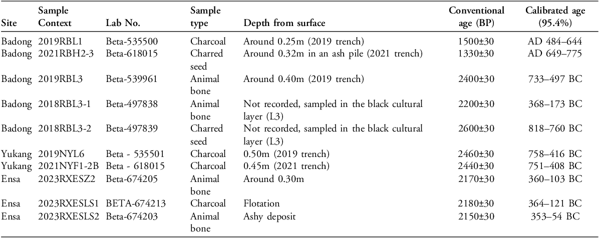
Radiocarbon dates on the material unearthed (Figure 7; Table 1) demonstrate long-term and discontinuous use of the Yukang and Badong sites during at least three periods: the first millennium BC, the historic period (c. fifth–eighth centuries AD) and the modern era. Two dates from the Ensa site suggest that the black ashy deposit also dates to the late first millennium BC. None of the sites yielded domesticated crops in our flotation samples (Li Tang, pers. comm.).
Radiocarbon dates from Badong, Yukang and Ensa. All dates calibrated with OxCal v4.4.4 and the IntCal20 calibration curve (Reimer et al. Reference Reimer2020; Bronk Ramsey Reference Bronk Ramsey2021; figure by authors).

Radiocarbon dates of the Badong, Yukang and Ensa sites.

Rethinking survey strategies in Tibetan archaeology
These three sites provide case studies for the successful identification of herding facilities using our survey method and encourage the reconsideration of archaeological survey strategies in pastoral landscapes. Archaeological research on the Tibetan Plateau suffers from a dearth of prehistoric sites, especially in the Tibet Autonomous Region and southern Qinghai (Aldenderfer & Zhang Reference Aldenderfer and Zhang2004). Scholars seeking to understand the geospatial patterns of known sites find a bias towards those recorded in the Atlas, and recent critiques question the over-reliance on the Atlas as a general trend in Chinese archaeology (Jaffe et al. Reference Jaffe, Castellano, Shelach-Lavi and Campbell2021). While we do not consider such a conceptual challenge solely associated with the archaeology of eastern China or the Tibetan Plateau in this case, it does call attention to data formation processes in archaeology and the level of tolerance for uncertainty in our narratives. There are previous reports of year-round, first-millennium BC settlements in the Shannon region, in the vicinity of Badong and Yukang (Lu et al. Reference Lu2021), yet the excavation of lowland agropastoral settlements is only the first step towards a comprehensive understanding of settlement patterns on the plateau. Sites located at varying elevations may represent different aspects of ancient communities and their subsistence and social activities. Given the high elevations of the sites in our surveys, we speculate that upland sites were probably used seasonally. Yet, this is an open inquiry that welcomes comprehensive ethnoarchaeological research in the future.
Although our surveys are limited to the mountainous regions near three villages—Remuna, Bangga and Rejiao—the results of the test excavations in and near modern corrals prove that herding facilities are among the most tangible archaeological features that are often overlooked. The findings resonate with previous suggestions for the comprehensive documentation of pastoral features in archaeology (Chang & Koster Reference Chang and Koster1986) and for developing alternative survey approaches in the high elevations beyond standardised surveys (Shuo Reference Shuo2010).
There are, of course, limitations to our approach. First, our newly recovered archaeological corrals are not artefact-rich, and thus contribute little to the cultural-typological sequence, despite such a regional cultural framework being much needed in Tibet. Second, although our field approach is labour-efficient, in the current scope, it is incapable of finding sites beyond those associated with modern corrals. Finally, our surveys were of necessity confined to the regions surrounding the upland river valleys near lowland prehistoric sites. It remains unclear what may be the best approach to conduct surveys in steppe-like environments such as northern Tibet, where nomadic pastoral activities may have taken place but population density was extremely low. The Tibetan grasslands lie in soil-depleted environments where locating ancient cultural deposits is even more difficult; construction projects in northern Tibet have successfully identified only a few archaeological sites (e.g. the Qinghai-Tibetan Railway Project; Xizang Bureau of Cultural Relics 2005). Future investigations into the diverse environments across the Tibetan Plateau will no doubt present further challenges and encourage additional conversations concerning archaeological surveys.
Conclusion
As an effort to develop an appropriate survey approach for the high elevations of the Tibetan Plateau and to evaluate the archaeological potential of previously neglected montane landscapes, we present the results of exploratory surveys in and near contemporary corrals in central-southern and western Tibet. In doing so, we draw attention to the distinct environmental conditions on the Tibetan Plateau and the seasonal and pastoral nature of site formation processes that call for a reconsideration of survey methods in future fieldwork. The use of satellite imagery and shovel testing presents a labour-efficient approach that is particularly suitable for regional surveys aimed at identifying new sites in historically pastoral landscapes, where high-altitude environments limit systematic field surveys. Shovel testing within or near corrals used by modern-day herders is a promising way of locating archaeological remains associated with ancient herders, provided pastoral facilities were reused in different periods, or identifying the long-term ecological effect of past herding activities. This approach may also apply to other regions across the world to explore ancient settlement patterns in marginal terrains.
Acknowledgements
This article is partially based on the doctoral dissertation of Xinzhou Chen (supervised by Prof. Michael Frachetti at Washington University in St. Louis, 2017–2023). We thank Zhen Zhao, Dingzeng Dajie, Ziyan Li, Jingman Wu, Xuan Gao and Xiran Yang for their help during the archaeological survey and Li Tang for information on the palaeobotanical assemblages at those sites.
Funding statement
The work reported here was financially supported by Washington University in St. Louis, Sichuan University and the National Social Science Fund of China (24CKG008, to X. Chen).