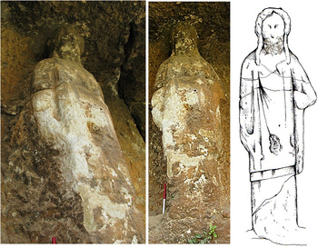
يثير الإهتمام على الأخص اكتشاف لتمثال صخري واضح التجسيم لديونيوسوس والذي يشير الى احتمالية وجود معبد في الهواء الطلق في منطقة بقارة. حيث يعد مثالاً فريداً لفن النحت الصخري في القيروان وقد يكون من أفضل الأمثلة المحفوظة من عالم الإغريق . هذا وتشهد هذه المعابد الصخرية على تبادل واضح بين العناصر الثقافية والفنية والشعائرية اليونانية–الرومانية والليبية والتي يميزها الطوبوغرافية الخاصة والفن المعماري وبُعدها عن المدينة. وتتفاوت مستويات التبادل والتداخل هذه من حالة إلى أخرى ومن حقبة زمنية إلى أخرى مما يشير الى درجات مختلفة من التأثير اليوناني –الروماني والذي يتناسب على ما يبدو، وبصورةٍ عامة، على بعدها من القيروان، الشىء الذي يتيح للقبائل المحلية ممارسة عباداتها وشعائرها الدينية بهامش من الحرية.
Introduction
One of the projects of the archaeological team of Chieti University in Libya was started as a study of the rocky ‘rural’ sanctuaries in the chora of Cyrene; it was then transformed into a wider GIS project for mapping and studying the extraordinary patrimony in rupestrian architecture, looking at both funerary and sacred spaces. Particular attention was paid to the areas to the east (Ain Hofra/Bu Miliou) and to the west (Baggara and Budrag) of Cyrene, which also represented the most problematic zones for looting and vandalism. Therefore, the principal need for these areas was to plan a project of mapping and recording that was as systematic as possible for this huge patrimony, starting from known bases (Cassel Reference Cassel1955; Ferri Reference Ferri1922a; Reference Ferri1922b; Reference Ferri1923; Stucchi Reference Stucchi1975; Thorn Reference Thorn2005) and then moving to the numerous ‘unknown’ monuments.
The resulting data, coming from surveys, non-invasive geo-prospecting, laser scanning of the main monuments, diagnostic mapping of the damaged monuments, as well as from the excavations, are recorded in a multilayer GIS (Geographic Information System) working as a data collector of the large amount of information (Menozzi Reference Menozzi, Menozzi, Fossataro and Di Marzio2008; Reference Menozzi and Ensoli2012). Obviously, the first problem was the complete lack of detailed and precise topographic bases, which has been solved using old maps integrated with ortho-rectified and geo-referred high-definition satellite images and positioning the finds with DGPS (Differential Global Positioning System). A second issue stemmed directly from the topography of the region, which does not allow for a systematic sampling strategy, but the study has been kept homogeneous using GPS tracks.
In combination with the survey, we continued the excavations in several areas, in order to have stratigraphic information from sample areas, which were chosen on the basis of both their typology/monumentality and the degree of risk of damage and looting. These monuments have been presented in several conferences and publications and they are certainly providing interesting new information and finds.
The project: methodologies and issues
The Intensive Survey project of Chieti University in Libya was started in 1999 with a preliminary survey in the area of Ain Hofra (Fabbricotti Reference Fabbricotti, Bonacasa and Ensoli2000; Reference Fabbricotti2007; Menozzi Reference Menozzi, Muskett, Koltsida and Georgiadis2002; Reference Menozzi, Fabbricotti and Menozzi2006; Reference Menozzi2007), which was in antiquity the site of one of the most spectacular rocky sanctuaries of the Cyrenaican chora (territory of the ancient colony). Since the first investigations, the territory appeared deeply influenced in its ancient exploitation and organisation by the local topography, which is strongly characterised by steep and deep widian (north-south orientated), or canyons, cutting vertically and regularly through the upland terraces and plateaux of Djebel Hakhdar.
From a methodological point of view, the sanctuaries have been surveyed with a combination of intensive and judgemental surveys, employing different teams of surveyors walking as regularly as possible, but often the locations of these sanctuaries, on the slopes of steep and narrow widian, do not allow parallel lines of walking surveyors. Therefore, in order to maintain a homogeneous survey, the GPS tracks have been recorded, multiplying them for the number of the surveyors and obtaining a resulting ‘plausible’ sampling strategy. The use of GPS in the project is therefore fundamental, not only for the location of the sites or for mapping particular areas, but also for controlling the developments of the survey project and for maintaining the sampling strategy as regularly as possible. The results of the survey are then recorded, in part during the survey, as well as in post-processing, in a multilayer GIS using high-definition satellite images and an old IGM (a map of the Italian Istituto Geografico Militare) as a topographic base. Moreover, the GIS is also used as a sort of ‘collector’ of the data, not only from the field survey, but also from the Remote Sensing, the geological survey and the ‘intra-site GIS' of the excavations.
In this way, the results are systematically processed, offering a solid base for further studies, reports, and any speculative research. However, after 15 years of surveys and excavations, the database is now so heavy and detailed that quick and easy manageability and transfer of the data are almost impossible, something especially needed to collaborate properly with Libyan colleagues. One of the first problems in this regard has been the use of different programmes, approaches, as well as ‘languages',Footnote 1 creating the need to find common protocols with Libyan colleagues concerning the survey and the processing of the data. Particularly for this reason, a specific programme of exchange of praxis and training has been organised with the Libyan colleagues;Footnote 2 scholars and technicians of the departments of antiquities (DoA), of universities and private companies, have come to Italy in the last two years to plan, organise and create common bases and approaches, aiming to gain in the future easily accessible and shareable databases, mapping and methodologies.
Moreover, one of the most problematic issues is still the use of very different choices of GIS software, which is becoming an obstacle in the sharing of the data not only with Libyan colleagues, but also with other foreign missions working in this area. Therefore, in order to improve collaboration with other teams surveying this territory, which is so rich in archaeological remains, and to look for a common solution of a more manageable and transferable GIS-based database, we are sharing our data with the Mapping Centres of Tripoli and Shahat,Footnote 3 as well as with colleagues from the American Archaeological Mission,Footnote 4 which is supporting the projects of the two Mapping Centres, and with the Italian Archaeological Mission of the ‘Soprintendenza del Mare’Footnote 5 and Libyan colleagues working in other private or public institutions.Footnote 6
herefore, a new frontier for all the teams, both local and foreign, working in field survey and mapping in Libya should be to find a common interactive database that is easy to manage, suitable for the training of local technicians, and which would also work on web bases, which could represent a common databank of all research and which could give to local departments of antiquities and universities better possibilities for managing and monitoring the huge and unique patrimony of this region.
Furthermore, looting, vandalism, abusive urbanisation, and lack of control over the exiguity of resources are all constantly threatening the monuments of this territory. This is becoming the most dangerous problem, especially during recent problematic months; certainly the next challenge that the international scientific community has to solve in collaboration with local scholars and technicians is how to protect, safeguard and manage this rich cultural heritage. Certainly fences, guardian services and constant surveys will help, but, in the longer term, the best safeguard and management of the monuments of this site must start with the training and informing of the local community through conferences, events, documentaries and public speeches in order to make them proud of their cultural patrimony and involve them in the control of these precious areas. It is a long process and, in order to be successful, it must start in the school systemFootnote 7 – even with lectures given by archaeologists in the classroom – with the creation of comics and cartoons about historical events, the participation of children in excavations or the cleaning of monuments, in order to create, through the ‘adoption’ of their cultural heritage, a stronger awareness of their own cultural bases.
However, in these highly problematic and risky times for Libya, all attempts to improve the situation are blocked because of even worse threats; we should all hope that these difficulties will be solved as soon as possible, first and foremost for the good of the nation and its peoples, in order to start, in a new and more peaceful Libya, to work again in a common effort to safeguard the archaeological, as well as the historical, architectonic, anthropological and environmental, heritage of this country.
The main rocky sanctuaries
The area located just to the west of Cyrene, known as Baggara and delimited by Wadi Bel Gadir and Wadi Bu Nabeh, presents several rocky sanctuaries, most of them with monumental architectonic features, such as Budrag, Ain Bueda and Belgadir, which have also been presented in other recent articles (Fabbricotti Reference Fabbricotti, Bonacasa and Ensoli2000; Reference Fabbricotti2007; Menozzi Reference Menozzi, Muskett, Koltsida and Georgiadis2002; Reference Menozzi, Fabbricotti and Menozzi2006; Reference Menozzi and Firpo2011).
The most representative from the architectonic point of view is certainly the case of Budrag (on the western slopes of Baggara), which is characterised by two main rocky cult chambers and other minor niches and caves. The rupestrian architecture of the sanctuary is also emphasised by the narrow but long staircase and path, directly cut into the rocky slope of Wadi Bu Nabeh, which represents the only way to approach the sanctuary and is particularly evocative of chthonian cults because of its long and descending passages (see Figure 1).
Budrag. Views of the staircases and passages and the two main ritual chambers.

The use and frequenting of the sanctuary, according to sporadic finds, date back to the Classical period, but in Roman times the sanctuary was transformed into a Mithraeum (Ferri Reference Ferri1922b), with continuity in its sacred use but with a strong change in the direction and typology of the rites. Moreover, this kind of sanctuary probably acted as a funerary space, being a main motivation in the choice of the remote location of tombs of persons devoted to their cults. In most of the cases, in fact, numerous and different kinds of tombs represent the most spectacular and monumental frame for these sanctuaries. The location of these tombs is also very interesting because an evident area of respect around the sacred space was always left in order to avoid any kind of contamination between the funerary areas and the sanctuaries. In the case of Budrag, the tombs are almost totally rock-cut because of the geomorphological context: they are mostly small and simple chamber tombs with very limited, mainly only hinted at, courtyards and rock-cut sarcophagi with gabled lids. The tombs surround the area of the sanctuary, framing and emphasising the sacred space, but at a consistent distance of about 350–400 metres. The main emphasis of this sanctuary is focused on the two main quadrangular rock-cut chambers (see Figure 1), showing the presence of water flowing from sources nearby, and numerous rectangular niches, probably for keeping votive gifts and/or the votive reliefs with the Greco-Libyan pantheon (which will be discussed below). The original dedications TAIΣ ΘEAIΣ and TOIΣ ΘEOIΣ can be read respectively on the back wall of the northern and southern chambers in a sort of differentiation between the female and male cults. These unnamed gods were probably the result of a syncretistic cult between Libyan chthonian deities and the gods of the Greco-Roman pantheon. Moreover, the long frequentation of these rocky shrines, as well as the cultural and ritual syncretism, are clearly attested by the palimpsest of inscriptionsFootnote 8 which can be found on the walls of the two chambers, mentioning also Apollo or Dionysus in later inscriptions, suggesting the evolution from an original chthonian cult for unmentionable, and probably unrepresentable, deities to Greco-Roman gods, but constantly maintaining separated cults for male and female for a long time. Moreover, during Roman imperial times, probably around the third century AD, there was the transformation into a Mithraeum, a chamber where the male cult was attested to be transformed, suggesting an awareness of the previous worship, probably because of its continuity of use.
Among the sanctuaries in the area of Baggara, it is important to mention the recently published sanctuary of the ‘Rocky Dionysus' (Fabbricotti Reference Fabbricotti2007; Menozzi Reference Menozzi and Firpo2011, 323–24; Reference Menozzi and Russo2015). It has been found on the eastern slopes of Baggara, between Alek Ain Bueda and Wadi Bel Gadir, close to a rich water source in combination with rock-cut altar-niches. The most representative find is a standing male figure in high relief, of 1.7 metres (see Figure 2), and the lower part is just roughly sketched as if to represent the base of a herm, coming directly out from the bedrock. The figure is wearing a long himation, completely enveloping the body and the arms, showing, just on the legs, a smooth and tight chiton. A short and small mantle of an animal skin, possibly a sort of pardalis, is covering the shoulders and the upper part of the bust. The head is represented in a frontal position, but slightly inclined downwards, suggesting that the eyes were turned towards those who were watching from below. The god is presented bearded with thick and curly hair, just sketched on the front, while more detailed hair strands fall over the shoulders for framing the face. A crown, just hinted at, keeps the hair on the head. The left arm is bent, as if holding something in the hand, an attribute which is now too worn and difficult to interpret. The right arm, kept down along his side, holds what could be interpreted as a branch rather than a thyrsus. The iconography of the statue is quite well known for the Archaic period, both on Attic black-figure vases and on statues or herms, but also in later versions in archaistic style, also influenced by the so-called (and improperly known) ‘Dionysus Sardanapalus' (bearded Dionysus), which has been attributed to Kephisodotos (or to his son Praxiteles). However, the style and the attributes seem to suggest the Archaic cult of Dionysus Orthos, which is attested in Attica on the occasion of the Lenean celebrations, or of Dionisos Perikionios of Thebe (Pausanias, Description of Greece: Boeotia, IX, 12.4), that is, generally a herm or a pole specially dressed up with a mask of Dionysus (see Figure 3). It represented the most ancient form of cult of this god and is widely attested by the oldest representations on the Lenean Stamnoi, which are preserved in the museums of Villa Giulia, Naples and Boston (see Figure 3), iconography which is generally attributed to the Painter of Villa Giulia. Moreover, the sanctuary is surrounded by funerary monuments, framing the sacred spaces but respecting the limits. Therefore, Dionysus in this context has a strong ‘kata-chthonian’ and eschatological meaning, emphasising the Archaic aspect of this god as promoter of the life/death/rebirth cycle of nature, as well as of psychopompos, all aspects of which were lost for this god between the fifth and the fourth centuries BC. The statue was probably the object of processions and rites, which included the crowning of the statue with ritual vegetal crowns; in fact, the only part of the statue not in relief, but complete, was the neck, at the back of which was a hole for hanging up the crowns. This ritual crowning is clearly represented in the Lenean Stamnos from Naples (see Figure 3), where the dress of the god is very similar, presenting both the tight chiton, the himation and the pardalis; moreover, the small trapeza for votive offerings on the stamnos find parallels with the rock-cut bench just close to the statue.
Baggara. The rupestrian statue of Dionysus.

Stamnoi with representations of Dionysus. The first on the left from Vulci, now in Paris, is attributed to the Painter of Eupolis, interesting because it represents the cult of Dionysus Orthos or Perikionios; then the series from Villa Giulia, Naples and Boston (below), which have been attributed to the Painter of Villa Giulia.

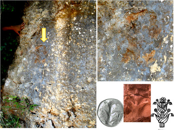
Among the possible rupestrian parallels can also be mentioned the so-called ‘Dionysus from Naxos', a colossal unfinished marble statue, which is still in one of the quarries of the island. This sacred statue, which is therefore closely related to the Greek Archaic aspects of Dionysus in elite worship is located close to the representation, in low relief, of silphium (see Figure 4), according to an iconography quite well known from other sculptures and coins (see Figure 4), closely linking the open-air sanctuary of Dionysus to the territory and to one of its most famous resources.
Baggara. A representation in low relief of the silphium, with some parallels on coins and from a capital from the house of Jason Magnus.

A second area of investigation, which has been intensively surveyed and excavated during last ten years, is the sanctuary at Wadi Ain Hofra. The area has already been presented in preliminary reports (Fabbricotti Reference Fabbricotti, Bonacasa and Ensoli2000; Menozzi Reference Menozzi, Muskett, Koltsida and Georgiadis2002; Reference Menozzi, Fabbricotti and Menozzi2006; Reference Menozzi and Firpo2011) and it was closely related to aristocratic cults in the Archaic and Classical periods; however, the typologies of remains are very varied and the GIS, which is still in progress, is showing a wide and complex view of ancient structures and monuments (see Figure 5). Out of more than 500 recorded remains, 35 per cent come from funerary contexts and different typologies of tombs are represented, with lower percentages of tumuli, circular tombs, while temple tombs, sarcophagi and funerary courtyards with loculi, or chamber tombs, are widely attested. Moreover, 65 per cent of the finds belong to different typologies of sites and structures, such as ancient road tracks at 25 per cent, votive contexts at 36 per cent, caves with long and continuous frequentation at 12 per cent, rocky staircases connecting different votive areas at 7 per cent, and a lower percentage of rural structures.
Ain Hofra. Above: a view of the so-called ‘Tomb-Sanctuary’. Below: the altar-niches of the western slope and the Ammon Shrine (C) before the excavation.

From a chronological point of view, in the north-western quadrant (see I in Figure 6), for the moment, are attested mainly late-Roman phases, consisting of small terraced areas used for farming. In the north-eastern area (see II in Figure 6), mainly funerary monuments are attested, dating to the Hellenistic period and often closely related to remains of roads or walls supporting terraces. The south-eastern quadrant (see III in Figure 6), where the survey is finished, presents tombs dating from the fourth century BC together with remains of an ancient road network and water pipes. The south-western quadrant (see IV in Figure 6) presents exclusively ritual and votive remains, such as cult chambers and votive altar-niches and naiskoi with Greek inscriptions.
Ain Hofra. Distribution of the main remains, shot from the GIS.

The sanctuary is dedicated to the Heroes, often associated with the Eumenides and Zeus Melichios, therefore with a strong chthonian emphasis and a very elitist worship. The cult of the Heroes (Hägg Reference Hägg1999), in fact, is generally a specific typology of devotion to the ancestors, closely linked in a colonial context to the celebration of the aristocratic gene ‘founding’ the colony (Antonaccio Reference Antonaccio and Hägg1999). It is particularly suggestive in this sense that the most ancient dedications mentioning HPΩN are in the niches (see B in Figure 5) around the so-called ‘Tomb-Sanctuary’ (see A in Figure 5), an earlier tomb dating to the sixth century BC, which was then transformed into the main cult chamber. The early and monumental porticoed tomb (A in Figure 5) had probably attracted, between the fifth and the fourth centuries BC, this typology of devotion, which then transformed the area into an open-air sanctuary with cult chambers (the Tomb-Sanctuary, A in Figure 5, and the so-called ‘Ammon Shrine’, C in Figure 5, which will be mentioned below), a large cave with the votive deposits (Cave W1), a series of altar-niches (Figure 5) with inscriptions and naiskoi, organised into three terraces on the south-western corner of the rocky slope of the wadi. Each single architectonic element has been rock-cut, including the small passages and staircases. The approach to the sanctuary must have been from above, where the pilgrims descended into the heart of the ritual space, that is the second chamber (the Ammon Shrine, C in Figure 5, and Figures 7 and 8). With the construction/quarrying of this second chamber, in fact, the focus of the sanctuary was moved from the earlier Tomb-Sanctuary and neighbouring niches to the second chamber just 20 metres below. This shift has resulted in a new typology of architecture, both for the chamber and for the altar-niches; all the niches around the earlier chamber were proper, complete niches, organised in rows along the descending path, while the later ones were altar-niches and naiskoi, which were disbursed along terraces above, below and on the same terrace as the second cult chamber.
Ain Hofra. The second ritual chamber or Ammon Shrine. A view of the klinai and of the botros.

Ain Hofra. Above: the northern wall of the Ammon Shrine with the inscription (shown to the right) above the altar. Below: the representation of Ammon.

This second rocky chamber (see C in Figure 5, before the excavation, and Figure 7) has been recently excavated, attesting, from the stratigraphic point of view, a complex use of the chamber and of the area. The cult chamber seems to have been cut originally for an early funerary use, or probably just suggesting a funerary architecture of a rocky ‘facade-chamber’ (Cassel Reference Cassel1955, 18–19; Thorn Reference Thorn2005, 335–42), with seven klinai regularly arranged on the three inner rocky walls of the tomb (see Figure 7). It soon became one of the centres of the cult of the ancestors (the Heroes), together with Zeus Melichios and the Eumenides, as attested by the inscription on the northern wall (see Figure 8): ΗΡΩΝ, ΚΑΙ ΜΕΛΙΚΙ(- -), ΚΑΙ ΕYΜΕΝΔ(- -).
The earlier triple dedication had later been erased and substituted with Ammon, suggesting that the earlier elitist worship was then replaced by the more popular cult of Ammon, probably in the Hellenistic period, according to the stratigraphic sequence. Moreover, again in this period, a low relief with a rough representation of this god was added just outside the rocky chamber (see Figure 8), showing Ammon in a very local and stylised interpretation with the head of a ram. The representation of this god as a ram in Cyrenaica is also quite well known from votive statuettes and coins, as, for instance, the coins issued at Barce. Here, the representation of a wooden pole dressed up as the god and bearing the head/mask of a ram is very suggestive.
Just a few metres from the Ammon shrine, the Cave W1 (see Figure 9) has been excavated since 2001. Two trenches had already been excavated in the past: the first one in the 1965 by Tinè, who found a long frequentation of the cave from the Paleolithic period, as a temporary refuge, to the Classical period, with Greek pottery dating to the fifth and fourth centuries BC; the second excavation was organised by the joint teams of Chieti University and the Italian Ministry of Cultural HeritageFootnote 9 in 2001. During this second excavation, only the upper levels were investigated and numerous miniaturistic vessels and terracotta figurines have been found, dating to the fourth and third centuries BC. During the seasons of 2006, 2007 and 2008, moreover, closer and more extensive investigation took place of the use of the votive deposits in the cave in order to understand their chronology and their possible connections with the cults in the area. Several structures (both wooden and stone) have been found, delimiting small rooms directly covered by the ceiling of the cave, which were probably used as deposits. The find of similar typologies of miniaturistic votive gifts (see Figure 10), including pottery (mainly oinochoai, kantharoi. olpai and a few pixeis), terracotta figurines and small flints in the second deposition, both in these rooms within the cave and in some of the altar-niches excavated nearby, has suggested the use of the rooms in the cave as votive deposits for the open-air sanctuary of Ain Hofra.
Ain Hofra. Cave W1, showing the locations of the votive deposits and views of the complex stratigraphic situation.

Ain Hofra. The finds from Cave W1.

The prehistoric levels in this cave have not been investigated yet because only after finishing the excavation of the votive deposits can the earlier levels be explored more properly in collaboration with prehistoric specialists. Moreover, in order to delimitate more closely the areas of the deposits/shrines within the cave, geo-prospecting surveys have also been performed (using a combination of magnetometric-graviometric and geo-resistivity methods), showing other smaller rooms and areas of possible deposits.
The excavation of the cave and of the second cult chamber are particularly interesting if analysed by combining the results, especially for hypothesising the period of the change of the dedication of the open-air sanctuary. A large collapsing of the ceiling in the cave and of some of the passages suggests that possibly a strong earthquake took place around the end of the fourth century BC, as the pottery which has been found just below large parts of the collapsed ceiling seems to suggest. Then the votive deposits were ‘restored’, even using part of the collapsed limestone as sections of the walls for the new rooms, in combination with inner wooden structures. By this point, certainly the typology of the cult had changed, because new terracotta figurines representing Bes, Pan and Paniscas appeared, giving the cave a new devotion with more naturalistic inclinations.
Around the middle/end of the third century BC, the second cult chamber had also changed its ritual use with the introduction of Ammon as the new and more popular god and with some readjustment work within the chamber. In fact, the earlier cult was characterised by klinai and a large botros (see Figure 7) instead of an altar, because it was used as a sort of nekromanteion for the aristocratic gene, which used the sanctuary for the good of the familiar clan and for expiating their hubris; with the change in the cult's devotions, the earlier triple dedication was erased, Ammon was introduced and one of the klinai just below the inscription was cut and transformed into an altar (see Figure 8), which is also mentioned in the new dedicatory inscription (Figure 8): ΤΑΔΕ ΠΡΟ ΒΟΜΙΟ / - - - ΙΟS / TO ANTRONI / KAI AMMONI-. It is now impossible to understand the rest of the name of the person dedicating the inscription and the altar to Ammon and to the cave/shrine, where just the end of the name ‘- - IOS', or maybe ‘- - SIOS', can be seen, using a four traits sigma. During the excavation of the rocky ‘altar’, moreover, a small bronze coin of Ptolemaic issue and dating to the middle/end of the third century BC has been found within a hole resulting from the cutting/quarrying of the preceding kline, when it was transformed into the altar for Ammon.
Therefore, the open-air sanctuary of Ain Hofra had a long ritual life but changed completely its cults, rites and kind of devotion within the third century BC. Furthermore, in another area of the sanctuary, mainly in the eastern slope of the wadi, different elements also suggest the introduction of a Mithraic cult, but this must be ‘another story’ because more excavations and studies are still in progress.
Analysing the rocky sanctuaries and the rupestrian ritual architecture, also the very numerous reliefs (see Figure 11) portraying Greco-Libyan gods (Fabbricotti Reference Fabbricotti1997), must be mentioned because they are an important testimony to the cults which must have existed in these contexts and to the rites which must have been performed. They show a quite standardised iconography with gods gathered in a rich pantheon, always presented within caves, in bucolic contexts, probably during night-time rituals (because the chariot of the sun is represented above the cave, in his early rising). These pantheons include both gods that are totally Greek in their iconography, such as Zeus, Ares, Athena and Apollo, as well as Libyan gods, such as the local chthonian nymphs or Ammon, or the Greco-Libyan hybrid version of Zeus Ammon, bearded and horned, and also Demeter and Kore in a Greek arrangement of the figures, but wearing Libyan dress. They are an interesting testimony of the cultural dialogue in this region among the different cults, iconographies and ethnic groups in Hellenistic and early Roman times, as well as of the typology of the cults and of the rites of these sanctuaries.
Cyrene Museum. Two examples of reliefs showing the so-called ‘Greco-Libyan pantheon’.

While these rupestrian sanctuaries are generally located a few kilometres from Cyrene, moving further out to the limits of the chora, other sanctuaries, such as Slonta (see Figure 12) and Martuba (see Figure 13), show different degrees of the Greco-Roman impact on the local culture. The rituals, the architecture and, in particular, the iconographies of sculptures and reliefs from these sites attest to a strong emphasis on more purely Libyan aspects. For example, at Slonta (Luni Reference Luni1987), although some of the pilgrims represented in high relief wear the chiton and himation and the altar shows Ionic decorations, the rituals and the iconographies seem to suggest more local cults, all set within a natural cave. The presence of the huge snake-god is particularly emblematic in this sense, as a chthonian and ancestral deity which is represented in high relief all along the rocky walls of the cave, as well as the representation of possible sacrifices of pigs on the altar and the faces almost evoking human sacrifices, probably just ideally. Moreover, the sculptural finds (see Figure 13) from the sanctuary at Martuba (Bacchielli Reference Bacchielli1987) also attest to a deep-rooted Libyan tradition, reinterpreting in a local version the typical iconography of Isis and her cult in Roman times. The goddess is represented more as a stone version of the wooden pole dressed up as Isis, rather than as a proper free-standing sculpture in the round.
Slonta. Views of the sculptures decorating the cave.

Statues of Isis from Martuba.

On the other hand, in general the iconography of Isis in Cyrenaica is very interesting for attesting the multiple aspects involved in the representation of this goddess, with such a Libyan interpretation from Martuba, as well as with iconographies that were more ‘Egyptianising’Footnote 10 or more Greco-Roman,Footnote 11 which have coexisted at Cyrene, coupled with a very classical interpretation, but with cultured hints at Libyan features, as in a find from the territory around the town. This last find (see Figure 14) consists of a small decorative element, which was sculpted on an earlier small half-marble column, representing, in a low but accurate relief, a frontal view of the head or mask of Isis, together with her sacred animal, the cobra, and a possible votive cist. Here the face/mask of Isis presents the features and iconography of the so-called Isis-Demeter LibyssaFootnote 12 in a sort of syncretism of the iconographies, but with attributes and probably rites which belong exclusively to Isis.
The marble sculpture which has been recently found in the territory of Cyrene. The area of provenance is not clear because it had been given to the DoA by local farmers.

Conclusions
The study of the extra-urban rocky sanctuaries, through survey and excavation, is providing important information concerning their early use and role as the main promoters of interaction between the Libyan and Greco-Roman communities.
The function of the extra-urban sanctuaries has mainly been discussed for the colonial poleis (Greco Reference Greco and Pugliese Caratelli1990; Leone Reference Leone1998; Pugliese Carratelli Reference Pugliese Carratelli1989) and for Cyrene (Bacchielli Reference Bacchielli1994; Fabbricotti Reference Fabbricotti2007; Menozzi Reference Menozzi, Muskett, Koltsida and Georgiadis2002; Reference Menozzi2007; Parisi Presicce Reference Parisi Presicce1984) in a general view and mainly as ‘radiating centres' for the ‘Hellenisation’ of the territory and of the local tribes, as well as serving as ‘political and cultural boundaries' of the polis and its chora (Di Filippo Balestrazzi Reference Di Filippo Balestrazzi, Fabbricotti and Menozzi2006; Fabbricotti Reference Fabbricotti2007; Menozzi Reference Menozzi, Muskett, Koltsida and Georgiadis2002; Reference Menozzi2007; Parisi Presicce Reference Parisi Presicce1984). However, this religious and consequentially political ‘acculturation’ of the territory should also be seen as a two-way process, in which the Greco-Roman world met the local pre-existing cultures and interacted with them in very different ways which also changed from period to period. Therefore, these sanctuaries can be seen as important manifestations of this two-way polyhedral interaction. In general, the impact on the local substratum of the Greek and Roman culture must not be interpreted as a ‘homogeneous phenomenon’, not only because the Hellenisation and the Romanisation were very different from period to period, but mainly because the local substratum itself was very different from the early periods of colonisation, when it was purely Libyan, to the Greco-Libyan substratum of the early Roman periods. Therefore, as elsewhere, the interaction must not be generalised or seen as identical and static in the long Greco-Roman history of Cyrene, but should be approached as different results and levels of a continuous and vivacious cultural and ritual hybridisation.
These sanctuaries are generally located on the steep slopes of deep widian (see Figure 15), typically associated with water springs and chthonian cults, and mainly monumentalised by rock-cut architecture. Several analogies for this rupestrian architecture, as well as for the typologies of the cults and the natural background, can also be found in the so-called ‘minor sanctuaries' in the Doric colonies of southern Italy (Genovese Reference Genovese1999), or in the extra-urban rocky sanctuaries of Lycia and Phrygia, which were frequently to be found close to funerary areas (de Francovich Reference de Francovich1990).
DEM (Digital Elevation Model) of the territory around Cyrene showing the location of the main widian (canyons) with sanctuaries.

Moreover, another feature of these rocky sanctuaries at Cyrene is their association with very monumental funerary areas, although always with an area of respect separating the two different sacred spaces; this is because the pilgrims devoted to the sanctuary did not want to directly invade the area dedicated to the gods. Similar situations are, for instance, attested for the sanctuary of Apollo Aleos at Cirò, close to Crotone, as well as for the Athenaion at Francavilla Marittima, or in more rural contexts such as at Cozzo Michelicchio, close to Corigliano Calabro, at Santa Maria del Castello at Castrovillari, and at Sant'Anna in the area of Crotone (Genovese Reference Genovese1999; Lattanzi Reference Lattanzi1996); in some of these cases, numerous tombs surrounded the sanctuaries, probably belonging to the people who paid for the construction or the reconstruction of these sanctuaries, or to the priests or priestesses administrating these areas and their cults. In this sense, very indicative is the finding on the architrave of one of the monumental tombs in the eastern slope of Wadi Ain Hofra, of the inscription: ΜΗΛΙΧ(- - -) ΙΑΡΕY(Σ),Footnote 13 suggesting the possibility of the burial of a priest, probably of (Zeus) Melichios, and for this reason buried in the area of the sanctuary.
The study of the agrarian subdivisions (Menozzi Reference Menozzi, Menozzi, Fossataro and Di Marzio2008) around these sanctuaries, which are investigated both during the field surveys and by remote sensing on high-definition satellite photos, is now giving interesting results. The area around the sanctuary of Ain Hofra, for instance, presents mainly fertile land plots with modules of agrarian repartition similar to the territories of Metaponto (Carter Reference Carter1977; Carter Reference Carter, Greco and Bats1991; Giardino and De Siena, Reference Giardino, De Siena and Greco1999) and of colonies on the Black Sea (Strželetskij Reference Strželetskij1961; Wasowicz Reference Wasowicz1972; Wasowicz Reference Wasowicz and Greco1999; Tsetskhladze Reference Tsetskhladze, Tsetskhladze and De Angelis1994; Tsetskhladze and Snodgrass Reference Tsetskhladze and Snodgrass2002), dating to the Late Classical period. Totally different is the situation of Baggara, alternating a few fertile areas with funerary areas intensively monumentalised and fields geologically characterised by superficial limestone, which were used for the pasture of flocks and cattle or for quarrying limestone. However, the agrarian repartitions are not limited to only the fertile areas, but also involve the other areas, with schemes dating to the Hellenistic period, similar to examples at Crete (Raab Reference Raab2001) or Corinth (Romano Reference Romano, Schowalter and Friesen1998; Romano Reference Romano, Williams and Bookidis2003), and therefore suggesting a repartition within the kleroi of rocky areas which were probably exploited as quarries. It could be hypothesised that these sanctuaries had also played a role in the exploitation and the organisation of the chora of the colony, both an aggregative role for the rural population, which lived in scattered farms and villages, and participated directly in the administration of nearby fields and resources. This aspect seems to be quite well attested in the Greek colonial world, such as in the famous case of the so-called ‘Tavole di Eraclea’, mentioning land plots and fields directly belonging to the sanctuaries. It is therefore plausible that, in Archaic and Classical times, the areas of Baggara and Ain Hofra, where evident remains of agrarian organisation are attested, even for early periods, could have presented idìa chora, that is private plots, together with large areas of koinè chora, collectively belonging to the polis, as well as ierà chora, closely related to the sanctuaries and directly administrated by them. This sort of mixed organisation also seems to be indirectly attested by the presence of Archaic and Classical tumuli or tombs, which are present only in some of the land plots – that is, just in private plots – and mainly in marginal areas of the private kleroi, as attested by, for instance, several sites on the Black Sea (Dufková and Pečírka Reference Dufková and Pečírka1970; Pečírka Reference Pečírka and Finley1973; Strželetskij Reference Strželetskij1961; Tsetskhladze Reference Tsetskhladze, Tsetskhladze and De Angelis1994; Wasowicz Reference Wasowicz1972; Wasowicz Reference Wasowicz and Greco1999), while it was absolutely forbidden in areas of the koinè chora and ierà chora (Muggia Reference Muggia, Camassa, De Guio and Veronese2000).
In general, parallels for the typology of the sanctuaries of Baggara and Ain Hofra can be found in southern Italy, such as in the area of Sibari (Greco Reference Greco and Lattanzi1996), or in the sites of Casa Murge and S. Anna di Cutro in the chora of Crotone, both associated with water springs and chthonian cults (Genovese Reference Genovese1999, 75–77),Footnote 14 or in the area of Locri (Genovese Reference Genovese1999, 108–109), especially for the case of Grotta Caruso (Arias Reference Arias1940; Costamagna Reference Costamagna and Lattanzi1987; Genovese Reference Genovese1999, 103–12; Sabbione and Schenal Reference Sabbione, Schenal and Lattanzi1996). Several analogies for the rocky architecture, the typologies of the cults and the natural background can also be found with the rocky sanctuaries of Lycia and Phrygia (de Francovich Reference de Francovich1990), which were often associated with funerary areas, as in the case here. Moreover, similar sanctuaries with water springs and cults for the nymphs or for ‘kurothrophic gods', often in association with Pan or Dionysus in pastoral areas or with dedications to the Heroes and/or to chthonian gods assimilated and syncretised with gods of the Greek pantheon in the presence of more aristocratic cults, are quite well known both in literary sources (Plato, Phaedrus, 5, 320; Anthologia Palatina, 9, 326) and archaeological contexts, for Athens, Delphi, in Phrygia, Lycia, Sicily, Magna Graecia, as also for Cyrene (Micheli and Santucci Reference Micheli and Santucci2000; Santucci Reference Santucci, Bonacasa and Ensoli2000, 55).
In conclusion, it is also important to emphasise that for Cyrene it seems to be anachronistic to group all of the extramural sanctuaries under the general category of ‘sacred belt’ or ‘sacred boundary’ of the colony. It is necessary to differentiate these sacred boundaries on the basis of their topography, architectonic features and distance from the town. The extramural large and monumental sanctuaries just around the colony must be considered the first ‘sacred belt’, very Greek in appearance, architecture and cults and acting as important poles for the Hellenisation of the chora. This first ‘sacred boundary’ includes the complicated system of shrines, temples and deposits of the Demeter sanctuary at Wadi Bel Gadir (Kane Reference Kane, Catani and Marengo1998, 289–300; Luni Reference Luni2006, 147–71; White Reference White1984), the Archaic Shrine of the Sphinx (Goodchild et al. Reference Goodchild, Pedley and White1966–67; Kane Reference Kane, Fabbricotti and Menozzi2006; Menozzi Reference Menozzi and Firpo2011; Reference Menozzi and Russo2015), the Sanctuary of Apollo Apotropaios,Footnote 15 as well as, in the earlier phases of the colony, the sanctuaries of Zeus (Bonacasa and Ensoli Reference Bonacasa and Ensoli2000, 137–48; Bonacasa Reference Bonacasa2007) and Apollo (Ensoli Reference Ensoli, Bonacasa and Ensoli2000; Reference Ensoli, Gonzàles, Ruggeri, Vismara and Zucca2008), which were at the beginning extra-urban sanctuaries, then included by the later phases of the circuit of the city wall, as was also probably the Temple of Aphrodite, mentioned only by Herodotus (Herodotus, The Histories, 2, 181–82), and the so-called ‘Doric Temple of the Collina Settentrionale’ (Stucchi Reference Stucchi1975, 21–22).
On the contrary, the rocky sanctuaries of Cyrene and its chora attest to a reciprocal osmosis occurring between Greco-Roman and Libyan cultural, artistic and ritual elements. Lastly, the levels of hybridisation and reciprocity are very various from case to case, from period to period, suggesting different degrees of the Greco-Roman impact, which seems generally to have been inversely proportional to the distance from Cyrene, also giving space and voice to the cults and rites of the local tribes.
Acknowledgements
Acknowledgements are due to all the institutions, both Libyan and Italian, which support this project in various ways: the Italian Ministry of Foreign Affairs, the Departments of Antiquities of Tripoli and Shahat, the Italian Embassy and Consulate in Tripoli, the Libyan Embassy and Consulate in Rome, the University G. d'Annunzio of Chieti, the Centre of the Athenaeum for Archaeometry and Microanalysis, the Geological and Paleontological Service of Chieti, the friends and the colleagues at the Italian Ministry for Cultural Heritage, and the Museum of Natural Sciences of Chieti.
I would also like to thank all the archaeologists, technicians and workers of the DoA of Cyrene-Shahat, who are collaborating with us in the surveys, excavations and restorations. It is a long list of friends, but they all must be mentioned: Farag Abdelati, Abdulrahim Sheriff, Mazin Abdalgader el Mziene, Fawzi el Raid, Monsef Nassr Ktab, AbdulKerim Farag, Hamdi Awad, Saed elAnabe, Abdalla Abreaek, Aissa Farag, AbdulSaleh, Mustafà, Hamsa el Mziene, Fathi, Kalifa Mohamed, and Abdulkerim.
Last but not least, I must personally thank all the members of the team who have worked hard, but who are always present, even in the hardest and most difficult moments: Eugenio di Valerio, Maria Giorgia Di Antonio, Clara Tamburrino, Silvano Agostini, Luca and Igor Cherstich, Angela Cinalli, Debora Lagatta, Maria Cristina Mancini, Marinella Urso, Ruggero d'Anastasio, Serena Torello Di Nino, Maria Lucia Amadio, and Jesus Lorenzo Himénez.