INTRODUCTION
Burnt lime has been a crucial component of Maya civilization starting from at least as far back as 1100 b.c. and continuing up through the present. It has been used for architectural, dietary, sanitary, preservative, and agricultural purposes, among others. Archaeologists often find samples of lime products, such as plaster and mortar, but the ephemeral nature of burnt lime itself in the archaeological record has limited the ability of researchers to trace the earliest lime production events. Identifications of ancient lime production localities are relatively restricted, especially in the densely forested Maya area. Researchers are now finding more evidence that lime producers in several subregions of the Maya area built pit-kilns at various points in time, but it is still possible that the majority of pre-Hispanic lime producers used aboveground pyres (Hansen Reference Hansen2000; Russell and Dahlin Reference Russell and Dahlin2007; Schreiner Reference Schreiner2002). Aboveground pyres often leave ambiguous or undetectable signatures in the archaeological record. Not only has the forested terrain of eastern Mesoamerica logistically hindered the identification of pre-Hispanic Maya lime production sites, it has in the past discouraged the search for such locations. A further problem in studying lime production is the possibility that lime kilns may have been built as temporary structures near quarries and were later destroyed or removed (Wernecke Reference Wernecke2008:205).
Despite these difficulties, an increasing number of inter-site surveys and salvage projects, as well as more detailed remote sensing technologies, such as Light Detection and Ranging (LiDAR), have begun to facilitate a greater understanding of the widespread pre-Hispanic Maya lime production industries over the past two decades. In shedding new light on pre-Hispanic Maya burnt lime production, these studies are demonstrating that people in different subregions of the broader Maya culture area used different production technologies and organization schemes. The pre-Hispanic development and recent identification of subregional discrepancies in lime production techniques appear to correlate with the following factors: (1) lime consumption requirements and the density of sites; (2) the availability of wood fuel; (3) local social and economic trajectories; and, perhaps most importantly, (4) the extent and objectives of archaeological research programs in a given subregion. The different lime production technologies, in turn, suggest differences in the environmental resource management practices and the socioeconomic organization of lime production in different subregions. Thus, we suggest a more accurate reference to pre-Hispanic lime production should refer to pre-Hispanic Maya burnt lime industries in lieu of the singular “industry.”
This paper presents a comprehensive, albeit concise, review of studies dedicated to pre-Hispanic Maya burnt lime production to date, and analyzes the variables influencing the development and archaeological identification of distinct subregional production methods. The paper also delves into the broader research issues surrounding pre-Hispanic lime production. It is worth mentioning here that the focus will be specifically on burnt lime and not burnt lime products such as plaster, mortar, or stucco. We produced this review and analysis to encourage current and future archaeological investigations in the Maya area to include a focus on identifying lime production signatures in their research agendas. As more data accumulate and are interpreted, archaeologists will develop a better understanding of the socioeconomic and resource management implications of these critical lime production industries.
BACKGROUND
The majority of the Maya lowlands are dominated by karst landscapes in which the bedrock is composed of limestone and dolomitic limestone, with the exceptions of the Tabasco floodplain, Usumacinta River drainage basin, and the coastal regions of Belize (Wernecke Reference Wernecke2005:9–13). The limestone is not uniform, however, and contemporary Maya distinguish grades based on color, hardness, and potential application, with only certain grades suitable for producing burnt lime (Seligson et al. Reference Seligson, Negrón, Ciau and Bey2017d). These different grades occur in patches and, occasionally, in uniform outcrops, but they also blend into one another to form the bedrock. The uppermost layer of hardened “cap-rock” limestone is often underlain by a softer saprolitic limestone called sascab, which occurs in patches below the surface (Beach et al. Reference Beach, Luzzadder-Beach, Cook, Dunning, Kennett, Krause, Terry, Trein and Valdez2015; Dunning Reference Dunning1992; Dunning et al. Reference Dunning, Luzzadder-Beach, Beach, Jones, Scarborough and Culbert2002; Wernecke Reference Wernecke2005:9–13). Thus, the geology of the Maya lowlands provides ample raw materials for the production of burnt lime with regard to calcium carbonate.
Burnt lime is created by exposing limestone or marine shell to temperatures of at least 800°C for a long enough duration to decompose carbonates and release carbon dioxide, which produces a caustic material called quicklime (calcium oxide). Water is then added to the calcium oxide, either manually or gradually through rainfall and atmospheric vapor, to produce the fine white powder known as burnt or hydrated lime (calcium hydroxide). The burnt lime can then be used for a host of purposes, including architectural, dietary, sanitary, storage, and others (Abrams and Freter Reference Abrams and Freter1996; Barba Pingarrón Reference Barba Pingarrón, Barba and Villaseñor2013; Mathews Reference Mathews2001; Morris et al. Reference Morris, Charlot and Morris1931; Russell and Dahlin Reference Russell and Dahlin2007:407; Schreiner Reference Schreiner2002, Reference Schreiner and Delage2004; Seligson et al. Reference Seligson, Negrón, Ciau, Bey and Rubenstein2017a, Reference Seligson, Negrón, Ciau and Bey2017b, Reference Seligson, Negrón, Ciau and Bey2017c; Villaseñor Alonso Reference Villaseñor Alonso2010:47; Wernecke Reference Wernecke2005, Reference Wernecke2008).
It is likely that the earliest instances of lime production in the Old World occurred by accident when peoples living in limestone-rich areas noticed changes in bedrock that had been exposed to fire for an extended period of time (Kingery et al. Reference Kingery, Vandiver and Prickett1988). There is no reason to believe that the earliest instances of lime production in Mesoamerica would have been any different. One can even imagine a scenario where lime production resulted from the observation of physical changes after the accidental burning of a residential structure with tamped sascab floors. Eventually these fortuitous observations were put to use and burnt lime was purposely produced. The earliest evidence for burnt lime in the world currently comes from Epi-Paleolithic Geometric Kebaran period (ca. 12,000 b.c.) sites in the Levant. Similar to the earliest evidence for lime elsewhere in the world, the Levantine evidence comes in the form of architectural lime products like plaster and mortar. The identification of early lime production locales is relatively rare compared with the evidence of lime products (Goren and Goring-Morris Reference Goren and Goring-Morris2008).
The earliest evidence for lime in Mesoamerica similarly comes in the form of lime products and not production features. Plaster floors and pits containing burnt lime powder have been reported at the site of San Jose Mogote in the Valley of Oaxaca dating to between 1400–1150 b.c. (Marcus and Flannery Reference Marcus and Flannery1996:83–87). Plaster coated the floors of structures that are believed to be among the earliest examples of public architecture in Mesoamerica and date to around 1320 b.c. (Marcus Reference Marcus, Sharer and Grove1989:163). It should be noted, however, that some of these early dates have been questioned and that there have been no chemical analyses performed to verify if these ancient plasters are indeed burnt lime-based (Barba Pingarrón Reference Barba Pingarrón, Barba and Villaseñor2013:29). The absence of chemical analyses raises the possibility that many early floors identified throughout Mesoamerica as being composed of lime plaster may in fact represent crushed and hard-packed sascab. This may lead to the over-estimation of lime consumption in certain cases. Marcus (Reference Marcus, Sharer and Grove1989:191) lists “the use of lime plaster for one-room public buildings by 1400 b.c.” as one of the features distinguishing early Oaxacan cultures from the Olmec cultures of the Gulf Coast. Indeed, there appears to be a complete absence of lime plaster or other lime products at the early Olmec centers of San Lorenzo and La Venta (Cyphers and Di Castro Reference Cyphers, Castro, Fash and Lújan2009:34; Flannery and Marcus Reference Flannery and Marcus2000:8). This is partially a result of the absence of locally available limestone and is reflected in the use of mud, earthen bricks, and pole and thatch in both residential and monumental architectural constructions (Diehl Reference Diehl, Benson, Coe and Grove.1981:69).
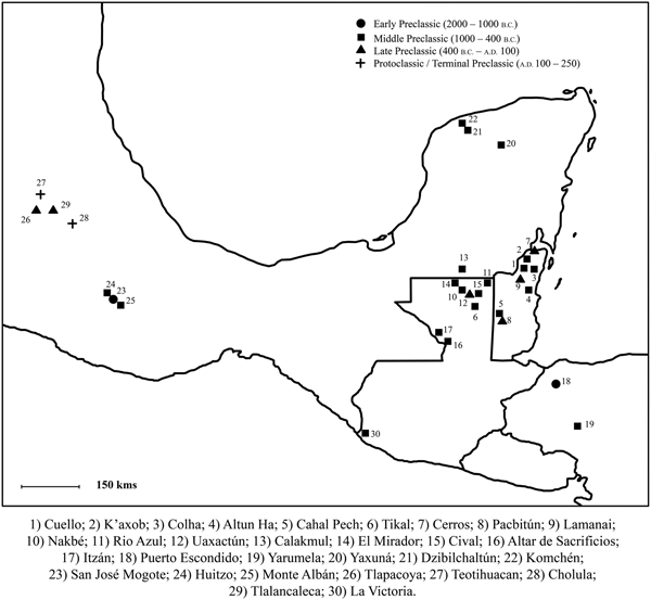
The earliest identification of burnt lime in the Maya area specifically comes in the form of lime plaster from the site of Cuello in Belize and dates to around 1100 b.c. (Hammond and Gerhardt Reference Hammond and Gerhardt1990:464; Hammond et al. Reference Hammond, Cartwright Gerhardt, Donaghey and Hammond1991:30–33). Almost all of the early evidence for lime production in Mesoamerica is identified in the form of burnt lime products like stucco or mortar, as few lime production features such as permanent kilns have been identified in the region. The fact that burnt lime products first appear in the archaeological record in subregions throughout Mesoamerica during the Preclassic period within what appears to be an approximately 200-year period suggests that burnt lime technology spread rapidly along existing trade networks (Figure 1). It is unclear for what function lime was first purposefully produced in the Maya area. Regardless of original purpose, however, starting in the early Middle Preclassic period the Maya began to produce burnt lime and have continued to do so in great quantities up through the present.
Map of Mesoamerica showing sites with the earliest reports of architectural lime (after Villaseñor Alonso and Barba Pingarrón Reference Villaseñor Alonso and Pingarrón2013).

THE IMPORTANCE OF BURNT LIME IN MAYA SOCIETY
Before delving into specific evidence of pre-Hispanic Maya burnt lime production, it is important to understand the central role that burnt lime has played in so many aspects of Maya society. Burnt lime can be mixed with water and aggregates, such as small pieces of stone or shell, to form a slurry that dries to form plaster, stucco, or mortar depending on the size of the aggregates. These lime products have been critical building materials in Maya communities for at least three millennia. Architectural lime has a greater chance of surviving in the archaeological record, and that is why the earliest evidence for burnt lime in the Maya region comes from architectural examples.
At some time, people noticed that exposure to lime increased the nutritional benefits of maize. Nixtamalization is the process by which maize is soaked in lime-infused water. This helps to remove the pericarp, softens the kernels for easier grinding, and, on a molecular level, unlocks nutrients that would otherwise not be absorbed upon consumption. It is possible that the discovery of the benefits of the nixtamalization process facilitated the transformation of maize into the staple crop of the Maya and Mesoamerican communities more broadly (Barba Pingarrón Reference Barba Pingarrón, Barba and Villaseñor2013:27–28). Concurrently appearing in the Maya region around the start of the first millennium b.c. were the production of burnt lime for architectural purposes (Hammond and Gerhardt Reference Hammond and Gerhardt1990:464; Hammond et al. Reference Hammond, Cartwright Gerhardt, Donaghey and Hammond1991:30–33), an increased reliance on a maize-based diet (Cheetham Reference Cheetham, Staller and Carrasco2010; Simms Reference Simms2014:76), and a population boom (Adams et al. Reference Adams, Hubert, Fred, Brett, Ruth, Demarest, Rice and Rice2004:329; Brenner et al. Reference Brenner, Rosenmeier, Hodell and Curtis2002:151; Deevey et al. Reference Deevey, Rice, Rice, Vaughan, Brenner and Flannery1979:301). It is likely that these were all factors in a positive feedback loop that led to increased complexity and the expansion of Preclassic Maya society. It is intriguing to consider that burnt lime production may have been closely connected with the growing significance of the maize-based portion of Mesoamerican diets leading up through the Middle and Late Preclassic periods. Unfortunately, at present such connections remain speculative due to the limited preservation of non-architectural burnt lime. The Maya have also been known to chew lime along with tobacco in order to enhance the effects of the plant's nicotine content (Villaseñor Alonso Reference Villaseñor Alonso2009; Wernecke Reference Wernecke2008). It is possible that this practice has pre-Hispanic origins.
In addition to the crucial architectural and dietary benefits of lime, lime plaster floors have provided a more sanitary and hygienic environment upon which the Maya perform daily activities (Barba Pingarrón Reference Barba Pingarrón, Barba and Villaseñor2013:21; Riquelme et al. Reference Riquelme, Alvarado-Ortega, Cuevas-García, Ruvalcaba-Sil and Linares-López2012:625; Villaseñor Alonso Reference Villaseñor Alonso2010:67). While many people would have continued to live the majority of their lives directly upon the soil, the widespread use of plastered house, plaza, and patio floors by even small segments of the population would have reduced exposure to pathogens. Thus, the introduction and use of paved living spaces led to better communal hygiene and helped stave off the deleterious effects of living in more densely packed communities. It is also the case for Teotihuacan that urbanization was supported by the use of lime-plastered floors to provide communal hygienic spaces (Barba Pingarrón and Cordova Frunz Reference Barba Pingarrón and Córdova Frunz2010). Lime is also important for food storage (Smyth Reference Smyth1990:54), in that it dries out and preserves maize while repelling consumption by animals and insects. It may also be used for agricultural purposes, in that it is an alkaline substance and can reduce soil acidity (Al-Bashaireh Reference Al-Bashaireh2008:72; Dunning Reference Dunning, Sabloff and Tourtellot1991; Villaseñor Alonso Reference Villaseñor Alonso2009:43). Villaseñor Alonso (Reference Villaseñor Alonso2009:43) lists other possible uses for lime in the Maya area such as, “water purification, soil stabilization and fiber softening for paper making[,]” though the reference to these possible practices are based on ethnographic comparisons and not definitive archaeological evidence. Lime may have additionally been used to coat the pages of the bark paper codices to provide a smooth, lasting writing surface (Coe et al. Reference Coe, Miller, Houston, Taube, Golden, Houston and Skidmore2015:117; Escalante Gonzalbo Reference Escalante Gonzalbo1999; Villaseñor Alonso Reference Villaseñor Alonso2009:43).
THE IDENTIFICATION OF SUB-REGIONAL LIME PRODUCTION INDUSTRIES
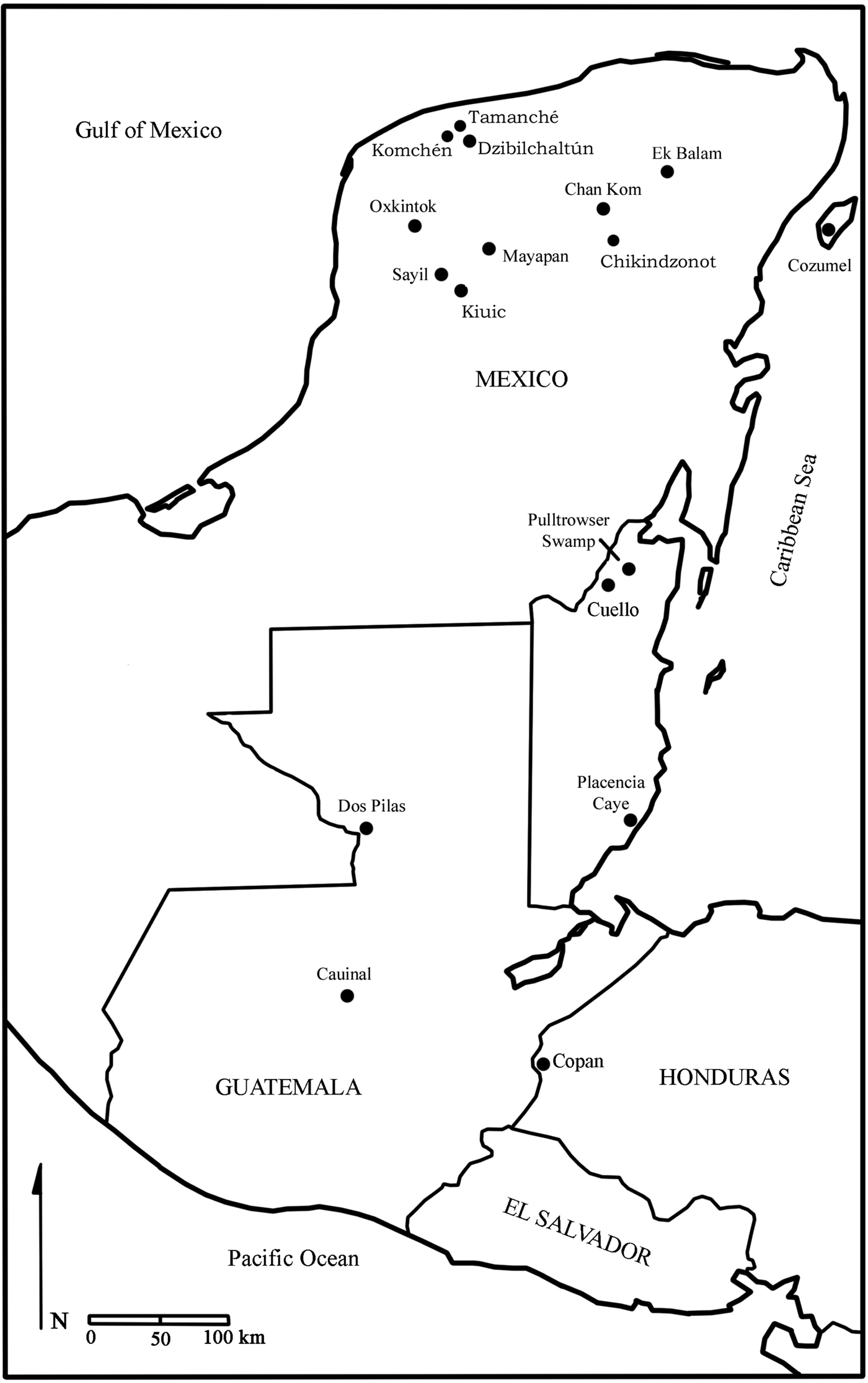
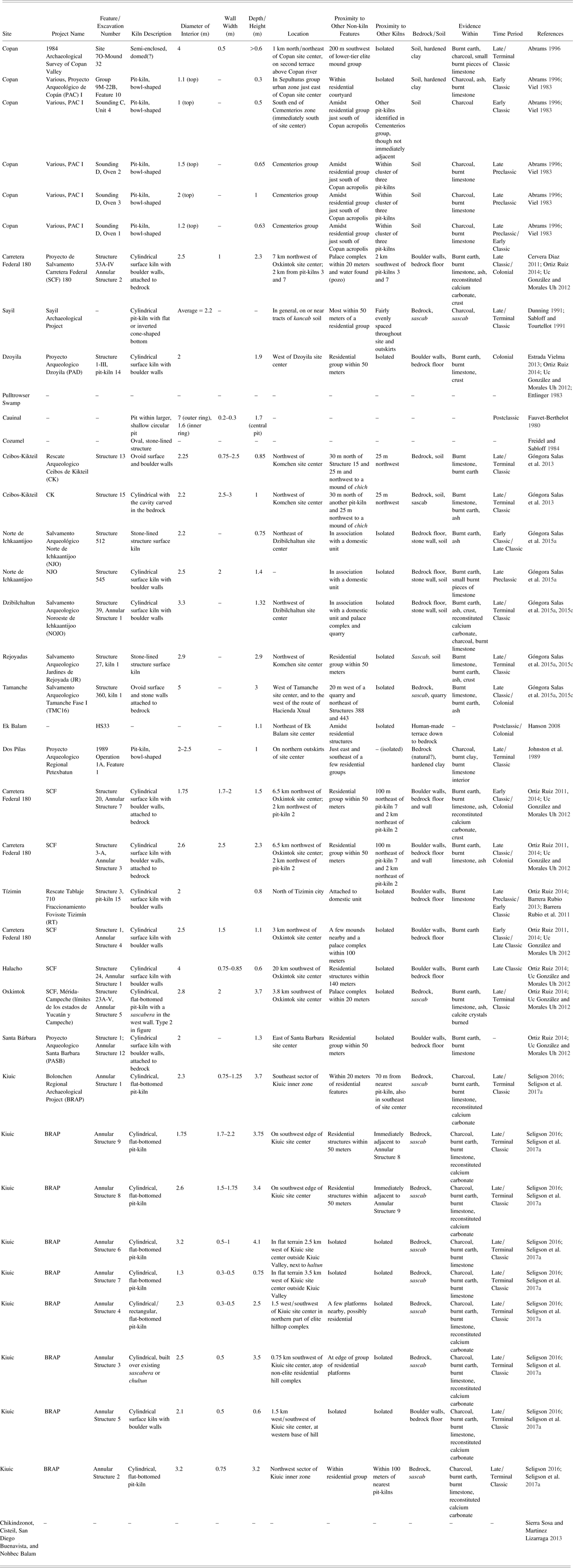
Considering the importance of burnt lime to so many aspects of Maya society, archaeologists have identified a relatively restricted amount of permanent pre-Hispanic lime production features (Figure 2; Table 1). Most of these identifications have been made in the last 35 years. This is largely a result of the issues outlined above, namely, the ephemeral nature of many lime production features and the difficulty of identifying even permanent lime production features in the heavily forested Maya region. It is also partially due to historical emphases on the investigation of monumental architecture and site centers, a practice that has only begun to change in recent decades. When archaeologists began to incorporate more rural settlement studies into their research programs in the latter half of the twentieth century, identification of potential lime production features remained a low priority, if it was even considered possible. Thus, only relatively recently in the history of Maya archaeology have researchers turned our attentions more to quarries and possible associated limestone processing areas.
Map of the Maya area showing sites where potential lime kilns have been identified (adapted from Seligson Reference Seligson2016).

List and descriptions of pre-Hispanic lime production features thus far identified in the Maya area.

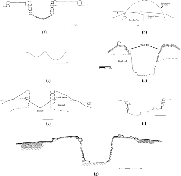
The growing number of confirmed pre-Hispanic lime production features throughout the Maya area now allows for preliminary analyses of distinct subregional lime production industries. We use the term “industries” to refer to variation not only in the morphology of the physical lime production features (Figure 3), but also in the organization and scale of lime production at the local community level. Our analysis highlights the importance of four main factors that have influenced the development and identification of subregional lime production industries: (1) lime consumption requirements; (2) the availability of wood fuel; (3) local social and economic trajectories; and (4) the extent and objectives of archaeological research programs in the given subregion.
A comparison of pit-kilns representing a typical example from the different subregional lime production industries identified in the article, as well a few of the additional isolated identifications: (a) Cauinal (after Fauvet-Berthelot Reference Fauvet-Berthelot, Ichon, Percheron, Breton and Fauvet-Berthelot1980); (b) Copán Semi-Encosed (after Abrams and Freter Reference Abrams and Freter1996); (c) Copán Round-Bottomed Pit (after Abrams Reference Abrams1996, Viel Reference Viel and Baudez1983); (d) Kiuic Annular Pit-Kiln (after Seligson Reference Seligson2016); (e) Sayil Annular Structure (after Dunning Reference Dunning, Sabloff and Tourtellot1991; Sabloff and Tourtellot Reference Sabloff and Tourtellot1991); (f) Ichkaantijoo Pit-Kiln (image by Ortíz Ruiz); and (g) Oxkintok Annular Structure (Ortiz Ruiz Reference Ortiz Ruiz, Goguitchaichvili and Morales2015).

The influences of the first two factors are closely intertwined. The availability of wood fuel can directly affect the rate of lime consumption and vice versa. Lime producers that were focused on increasing fuel efficiency would have favored production in enclosed or partially enclosed firing features, which require less wood fuel to produce the same amount of burnt lime as open-air firing features (Abrams Reference Abrams1996; Abrams and Freter Reference Abrams and Freter1996:426; Russell and Dahlin Reference Russell and Dahlin2007:409, 420; Seligson et al. Reference Seligson, Negrón, Ciau and Bey2017b). Seeing as how the benefits of semi-enclosed firing features are readily observable and fairly common sense, this production method would likely have been known to communities throughout the Maya area. Following this logic, the quantity of pit-kilns, as well as their average depth, should be greater in areas where fuel sources may have been more strained, such as in the Terminal Classic Puuc Region (Seligson et al. Reference Seligson, Negrón, Ciau and Bey2017b). At the moment, however, we cannot conversely say that the absence of pit-kilns in a given region reflects the lack of urgent need or desire to limit fuel consumption, for the lack of identification of pit-kilns may instead reflect gaps in survey data.
In addition to the environmental and lime consumption influences, it is also important to recognize that local, potentially inscrutable, social and economic factors may have influenced both the forms of burnt lime technologies and the ways in which burnt lime production was organized. Whether using aboveground pyres or permanent kiln structures, lime production requires substantial fuel resources and labor. This suggests that local lime production industries would have played important roles in pre-Hispanic Mesoamerican socio-economies (Barba Pingarrón et al. Reference Barba Pingarrón, Blancas, Manzanilla, Ortiz, Barca, Crisci, Miriello and Pecci2009; Barba Pingarrón and Córdova Funz Reference Barba Pingarrón and Córdova Frunz1999:169; Murakami Reference Murakami2010:354; Murakami et al. Reference Murakami, Hodgins and Simon2013:962), and pre-Hispanic Maya socio-economies in particular (Seligson Reference Seligson2016; Seligson et al. Reference Seligson, Negrón, Ciau and Bey2017b, Reference Seligson, Negrón, Ciau and Bey2017c). After the lime powder was produced, it had to be transported and/or mixed with other materials to create finished and usable products. All of these steps required organization, cooperation, and direction (Abrams Reference Abrams1987:493–496, Reference Abrams and Freter1996:206; Schreiner Reference Schreiner2002:68–72, 99–102; Seligson et al. Reference Seligson, Negrón, Ciau and Bey2017c).
Due to the amount of materials and technical knowledge involved in efficient lime production, it is possible that different specialists oversaw different steps in the process. These specialists likely managed laborers organized by small-scale corporate groups. Specialists had to locate and direct the excavation of outcrops of specific grades of limestone that were most desirable for producing lime powder. This required knowledge of limestone grades, where to access them, and how to extract them (Abrams Reference Abrams1996:205; Carmean et al. Reference Carmean, McAnany and Sabloff2011:147–148). Lime producers also had to be knowledgeable about the different tree species that provided the best woods for lime production (Russell and Dahlin Reference Russell and Dahlin2007:410–413). The transportation of raw materials to production sites required a significant amount of labor to chop wood and crush the limestone to manageable sizes at the quarry site or carry large pieces of limestone out of the quarry (Abrams Reference Abrams1987:493–494). A combination of the logistical issues, fuel requirements, and consumption rates led to the development of different organization schemes in different subregions of the Maya area. Discrepancies in lime production industries may therefore have been the result of idiosyncratic socio-economic and labor organization systems that were already developing or institutionalized in a given region by the time lime production became an important industry.
A final, particularly important, factor influencing the identification of subregional lime production industries is the differential coverage of archaeological research projects. The lack of identification of lime production features in some subregions of the Maya area, which therefore restricts our ability to understand the lime production in the industry, may result from a failure to identify lime production features that are indeed present. Analyzing the data that are currently available, which overwhelming come from the northwest of the Yucatan Peninsula, we identify at least four distinct subregional lime production industries, and a fifth general category pertaining to aboveground lime production. In the following sections, we provide brief descriptions of these five distinguishable lime production industries, and then delve into an analysis of the factors influencing their discrepancies.
The Eastern Puuc Lime Production Industry
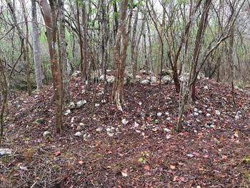
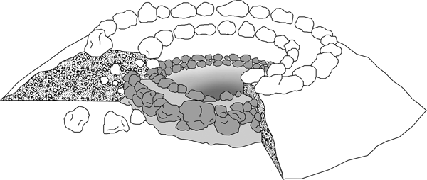
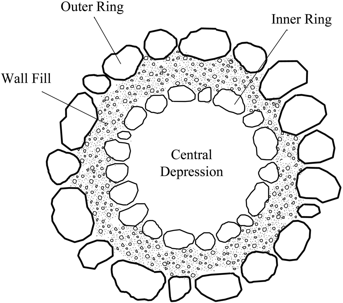
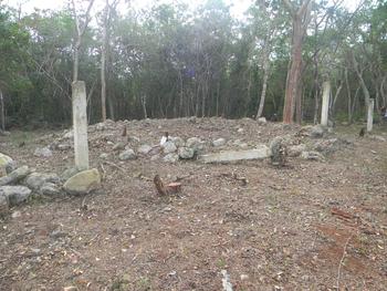
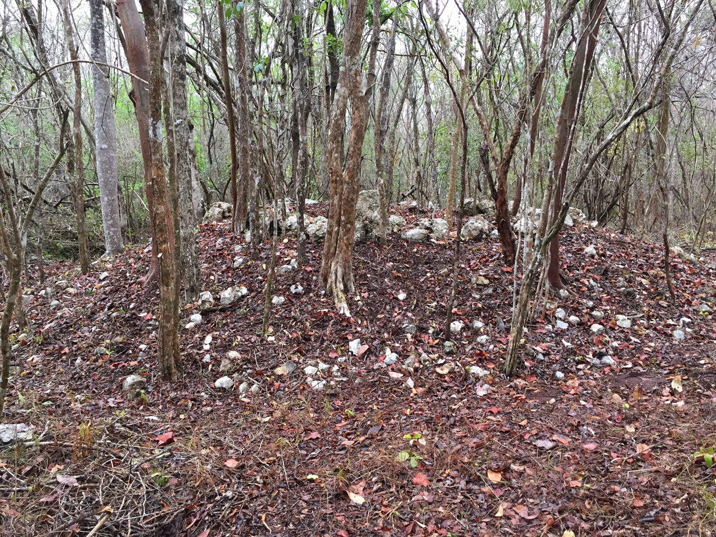
A distinctive form of annular pit-kiln for lime production has been identified in the eastern Puuc region of the northern lowlands, largely as the result of a 9-km2 inter-site survey between Labna and Kiuic directed by Gallareta Negrón and colleagues (Reference Gallareta Negrón, Bey and Ringle2014). The typical Puuc annular pit-kiln is composed of a sloping berm of chich (which are roughly fist-sized pieces of limestone) capped by a single or double ring of boulders that surrounds a deep central depression (Figures 4–6). Sabloff and Tourtellot (Reference Sabloff and Tourtellot1991) identified several of these cylindrical, flat-bottomed pit-kilns in and around the site of Sayil. Dunning (Reference Dunning, Sabloff and Tourtellot1991) ruminated on the frequency of these pit-kiln features in the Puuc region and their possible connection to associated tracts of otherwise fertile, but low-phosphorous kancab soils. While he did not excavate any of the annular structures at Sayil, he recovered a core sample from one and conducted preliminary surface evaluations of others. Based on their proximity to kancab soils and the core sample's mixture of what he identified as sahcab (or sascab) and charcoal, he hypothesized that the annular structures may have been used to produce a type of soil fertilizer (Dunning Reference Dunning, Sabloff and Tourtellot1991:25). Phosphate analyses of samples from similar kilns suggest that fertilizer production was highly unlikely, and it is also possible that the sascab sample recovered from the annular structure core at Sayil was, in fact, reconstituted calcium carbonate, which would point to the structure's use as a lime production pit-kiln.
One of the annular pit-kilns excavated at Kiuic (from Seligson Reference Seligson2016).
Schematic cross-section drawing of a Kiuic double-ring annular structure, showing an earlier construction phase of the feature (from Seligson Reference Seligson2016).

Top-down schematic drawing of a standard Kiuic double ring annular pit-kiln (from Seligson Reference Seligson2016).

Similar annular pit-kilns to those identified at Sayil were documented during the Labna-Kiuic inter-site survey (Gallareta Negrón et al. Reference Gallareta Negrón, Bey and Ringle2014). The excavation of a sample of nine of these structures in and around the Kiuic site core indicated that they were, in fact, used for the production of burnt lime and dated to the Late and Terminal Classic periods (a.d. 600–900; Seligson Reference Seligson2016; Seligson et al. Reference Seligson, Negrón, Ciau, Bey and Rubenstein2017a, Reference Seligson, Negrón, Ciau and Bey2017b). The majority of these features had deeper central depressions than lime pit-kilns identified in other subregions of the Maya area. Additional identifications of annular pit-kilns in the Puuc region have been made by Gallareta Negrón and May Ciau along the Sierrita de Ticul that marks the northeastern boundary of the Puuc Region, and at the site of Xcorralche (Seligson et al. Reference Seligson, Negrón, Ciau and Bey2017c).
The Oxkintok Lime Production Industry
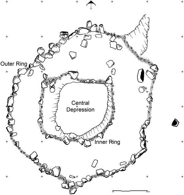
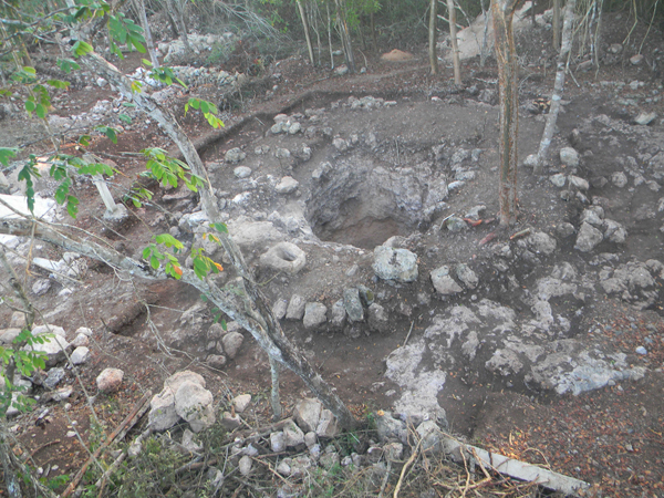
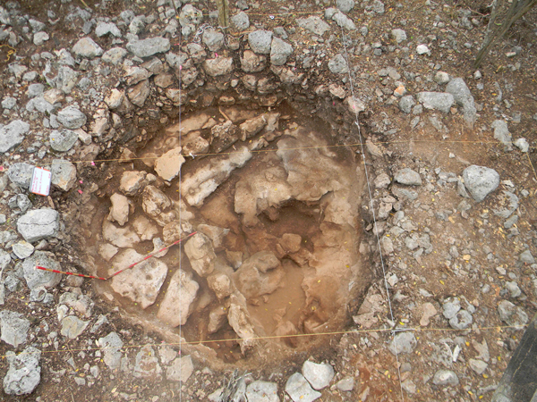
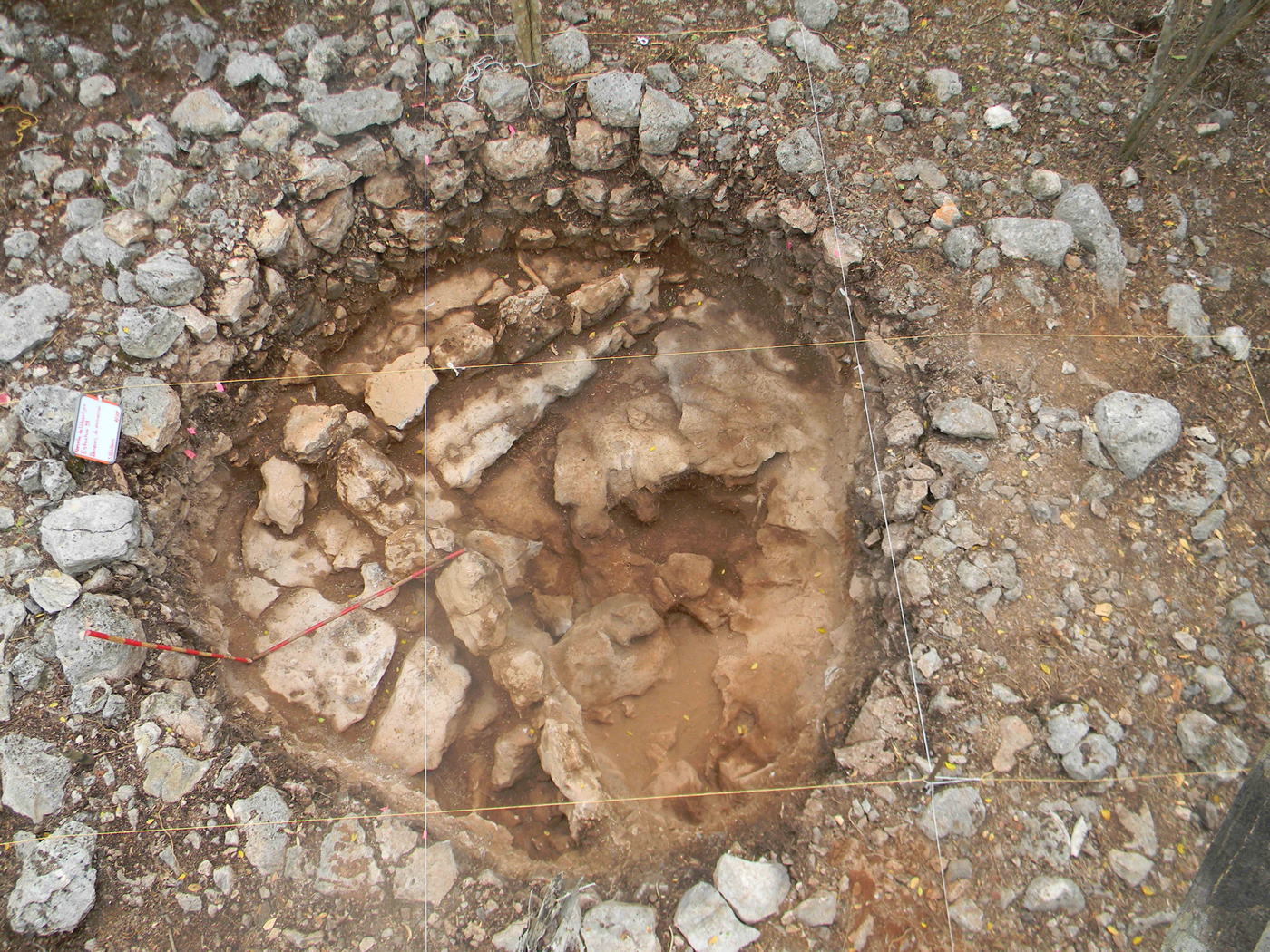
Archaeologists working on a highway salvage project near the pre-Hispanic site of Oxkintok at the northern edge of the Puuc Region discovered at least 13 annular pit-kiln structures, albeit with slightly different construction forms than those found in the eastern Puuc (Figures 7–9; Ortiz Ruiz Reference Ortiz Ruiz2014; Ortiz Ruiz et al. Reference Ortiz Ruiz, Goguitchaichvili and Morales2015). Seven out of 13 of the identified annular structures were excavated and returned evidence of lime production, with archaeomagnetic dates ranging from the Late Preclassic period up through the Colonial period.
Top-down schematic drawing of an Oxkintok annular pit-kiln (from Ortiz Ruiz Reference Ortiz Ruiz2014).

An annular pit-kiln before excavation at Oxkintok (from Ortiz Ruiz Reference Ortiz Ruiz2014).

An annular pit-kiln after excavation at Oxkintok (from Ortiz Ruiz Reference Ortiz Ruiz2014).

Compared with the Eastern Puuc annular pit-kilns, those of Oxkintok tend to be slightly shallower on average, and are surrounded by much wider double-rings. They also tend to have slightly sloping interior walls, giving the central depressions a cone-like shape with flat bottoms. Ortiz Ruiz (Reference Ortiz Ruiz2014) has identified four subtypes of annular pit-kilns at Oxkintok that can be distinguished by the presence or absence of interior walls made of roughly cut boulders that abut the bedrock, as well as the presence or absence of additional cavities excavated laterally into the exposed bedrock walls.
The fairly wide distribution of the lime pit-kilns on the outskirts of Oxkintok suggests that lime production was similarly widely dispersed throughout the community as it was in the Eastern Puuc. Pit-kilns have been identified in association with residential features of a wide range of sizes and construction materials, including small residential structures, and in one case a large palace complex. The pit-kilns also appear to be closely associated with quarries and chich mounds, which is not surprising given their obvious connections to lime production. While the wide distribution of annular structures suggests that many members of the community would have had access to this lime production technology, there does appear to be a correlation between the size of the pit-kiln and the size of the nearby architectural features (Ortiz Ruiz Reference Ortiz Ruiz2014). This connection between pit-kiln size and the quantity of lime that would have been necessary in the construction and upkeep of nearby architectural features is unsurprisingly a pattern also recognized in the Eastern Puuc and in the Ichkaantijoo region. Future research programs in the Maya area should keep this correlation in mind when attempting to identify lime production features.
The Ichkaantijoo and Northwest Coast Lime Production Industry
High concentrations of lime pit-kilns have recently been identified to the north and west of Merida at the sites of Dzibilchaltun, Tamanche, Conkal, Ceibos-Kikteil, Sacnicte, and Rejoyadas under the direction of the Ichkaantijoo Regional Archaeological Project (Góngora Salas et al. Reference Góngora Salas, de la Cruz and Ruiz2015b, Reference Góngora Salas, Ruiz and Cob2015c). The construction forms of the northwestern annular kiln structures differ slightly from those previously reported at Kiuic and Oxkintok. The northwestern kilns are divided into three general categories: the first is an inverted cone excavated into the bedrock with a single wall of stone surrounding the central depression; the second type is built on top of the bedrock in the form of a miniature volcano, with a conical-shaped depression in the center; and the third type is a very shallow pit, only a few centimeters deep, surrounded by a wall of irregularly-shaped boulders. It is unclear whether these different pit-kiln types reflect slightly different functions. In the northwestern sector of Dzibilchaltun, Ortiz Ruiz and colleagues used infrared spectroscopy to preliminarily identify the only example of a fourth type of pit-kiln in which an interior wall separated the combustion zone from the limestone storage area (Figures 10 and 11). The physical evidence gathered from the excavation of these features indicates that they were used for lime production, as does their contextual association with quarry and sascabera complexes. Ceramic data has been used to date the construction and use ranges of the features to the Late Preclassic through the Terminal Classic period. The clustering of sites and dense populations (Maldonado Cardenas et al. Reference Maldonado Cardenas, Gongora, Castillo, Arroyo, Paiz and Mejia2012) in this region suggest a need to conserve fuel in the face of high demand for lime across this broad time span.
Top-down photo of the distinctive Dzibilchaltún pit-kiln that possessed separate combustion and limestone areas. Photograph by Ortiz Ruiz.
Top-down schematic drawing of the distinctive Dzibilchaltún pit-kiln that possessed separate combustion and limestone areas. Drawing by Ortiz Ruiz.

In addition to the pit-kilns, Góngora Salas et al. (Reference Góngora Salas, de la Cruz and Ruiz2015b, Reference Góngora Salas, Ruiz and Cob2015c) also identified a small sample of potential open-air lime production features during the completion of an archaeological salvage project around the site of Dzibilchaltun in the early 2000s. These features appear in the archaeological record as circular burned portions of exposed bedrock with a scatter of partially burned pieces of chich (Góngora Salas et al. Reference Góngora Salas, Cortez Aviles, González and Ruiz2009). Unfortunately, no calcium carbonate samples were collected at the time of the excavation that can be used to confirm the production of lime specifically. If these do, in fact, turn out to be open-air firing features, this might provide evidence for the simultaneous use of pit-kiln and aboveground lime production technologies, pending dating.
The Dzibilchaltun pit-kilns are associated with domestic units, and exhibit a wide variety of shapes and sizes that may reflect the differential access to resources of the domestic units that controlled them. The majority of the pit-kilns are clustered within a three kilometer radius to the north of the site center, which in turn suggests that this northern area of the site may have been a neighborhood of domestic groups specifically devoted to lime production. The largest pit-kiln is located within a residential group with masonry architecture that is also the closest group to the site center. Domestic units without masonry buildings have smaller pit-kilns and are located further away from the site center. While the majority of lime pit-kilns thus far identified at Dzibilchaltun do indeed cluster in the northern part of the site, there are also isolated pit-kilns scattered throughout the site, including a few that are associated with the monumental and public architecture in the nuclear zone of the site.
The Copan Lime Industry
Archaeologists working at Copan, Honduras in the 1980s uncovered part of a feature that appeared to be a semi-enclosed or domed lime kiln, the only pre-Hispanic kiln of its kind yet identified in the Maya area (Abrams Reference Abrams1996:200–201). The top part of the kiln appeared to have been sheared off by modern plowing activities in the region, leaving the original shape somewhat ambiguous. In addition to this isolated semi-enclosed kiln, archaeologists also identified a series of shallow pit-kilns with bowl-shaped interiors that appear to have been used for lime production just to the south and east of the site center (Abrams Reference Abrams1996:202–204; Viel Reference Viel and Baudez1983:480–490; Whittington Reference Whittington1991). The identification of only a handful of lime production features in and around Copan suggest the lack of need to conserve fuel, or that the use of wood fuel for lime production would have been negligible (Abrams and Rue Reference Abrams and Rue1988:390).
The lower lime requirement likely influenced the different form of lime production organization that has been identified for Copan. Abrams and Bolland (Reference Abrams and Bolland1999) postulated that lime production at Copan could have been overseen by relatively few lime production specialists who would have managed a workforce of largely unskilled laborers. If less overall lime was consumed annually at Copan than in the Puuc region, for instance, it would only be natural that there were fewer lime producers. Lime production would thus not have been as viable as part of small-scale multi-crafting strategies.
The five Copan pit-kilns were dated to the Late Preclassic and Early Classic periods (Abrams Reference Abrams1996). This suggests that there may have been an effort, however limited, to conserve wood fuel during what Manahan and Canuto (Reference Manahan and Canuto2009) refer to as the Protoclassic period. The population of the Copan Valley appeared to be growing during this period, perhaps as populations moved eastward from the Guatemala highlands (Manahan and Canuto Reference Manahan and Canuto2009:556), and it is possible that this led to a desire for somewhat increased fuel efficiency. The fact that only five such lime pit-kiln features have been identified, however, and that they are fairly shallow compared with the pit-kilns of the northern lowlands suggests that limiting fuel use was not an outsized concern. The identification of the semi-enclosed kiln dating to the Late Classic period would suggest a renewed desire during that time period to conserve wood fuel, but its solitary status again connotes a limited emphasis on fuel protection.
A similar shallow, bowl-shaped pit-kiln form was potentially identified at Dos Pilas, Guatemala (Johnston et al. Reference Johnston, Inomata, Palka, Demarest and Houston1989:32). Despite the fact that the interior of the Dos Pilas pit feature was heavily burned, however, there was no specific evidence for lime production encountered and the central depression may have been a natural topographical feature. The similarity in the forms of bowl-shaped pit-kilns at Copan and Dos Pilas in the Maya area with early pit-kiln technology in the Levant (Schreiner Reference Schreiner2002:93) reflects the recognizable increased efficiency and structural stability of burning the lime in depressed areas as opposed to flat ground. While the use of this pit-kiln for lime production may indicate a desire to increase the efficiency of lime production at Dos Pilas, the fact that it is the only such pit-kiln example identified at the site suggests that fuel conservation was not a top priority. The fact that Dos Pilas was founded rather late in the course of the Classic period may underlie the limited need for increased lime efficiency, but the lack of lime production feature identifications may also relate to limited survey coverage or objectives.
Aboveground Lime Production Industries
The remains of pre-Hispanic open-air pyre firing sites have been understandably even more difficult to identify than lime production pit-kilns in the Maya area. Not only are ancient burned patches of ground difficult to locate in the first place, but oftentimes the aboveground burning of other materials may leave signatures to similar lime burns. Only a handful of archaeologists have identified such surface firing features, including Russell and Dahlin (Reference Russell and Dahlin2007), who identified the remains of seven surface lime production features outside the walls of Mayapan. They appeared in the archaeological record as round areas five to seven meters in diameter with much ash, carbon, and partially burned pieces of chich. They hypothesized that shallow pits containing the remains of lime slaking episodes in the form of lime products should be found near to these round burning areas, though it is unclear whether this was the case for the Mayapan production areas (Russell and Dahlin Reference Russell and Dahlin2007:421). Based on the location of these lime production areas, they also suggested that future attempts to identify lime production in the archaeological record should look to the outskirts of settled areas where fuel resources were more readily available. MacKinnon and May (Reference MacKinnon and May1990) identified the remains of a similar form of aboveground firing feature at Placencia Cay in Belize. They drew analogies from contemporary lime production methods in the vicinity of the pre-Hispanic feature to help identify it as related to lime production and noted that, like the contemporary lime, the pre-Hispanic lime at the site would have been produced from marine shells. Along with burning features, they identified remains of ceramic platters that would have been used for burning the marine shells down into quicklime. This identification of ceramic materials associated with lime burning provides an indicator that researchers should look out for when excavating open-air firing features, especially near the coast.
DISCUSSION
The four subregional industries described in the previous section can be distinguished from one another as well as from the aboveground production category based on the forms, frequencies, and contexts of the lime production features. The development of the different industries in the pre-Hispanic Era, as well as the identification of these industries in recent decades, can be traced back to environmental, socio-economic, and archaeological factors.
The prevalence of lime production features and their great average depth in the Eastern Puuc (Sabloff and Tourtellot Reference Sabloff and Tourtellot1991; Seligson et al. Reference Seligson, Negrón, Ciau, Bey and Rubenstein2017a, Reference Seligson, Negrón, Ciau and Bey2017b, Reference Seligson, Negrón, Ciau and Bey2017c) likely reflects the high density of sites and the frequency of masonry structures in the region during the seventh through tenth centuries a.d., when the pit-kilns were in use (Gallareta Negrón et al. Reference Gallareta Negrón, Bey and Ringle2014; Seligson et al. Reference Seligson, Negrón, Ciau and Bey2017b). Based on the dense concentration of sites, much of the fertile flat tracts of land between the hills in the Puuc region would have been cleared for agricultural purposes by the end of the Terminal Classic. This, coupled with a continuously growing population and expanding construction programs, may have begun to strain resources. Seligson and colleagues (2017b) studied the fuel efficiency of the pre-Hispanic Puuc annular lime pit-kilns at the site of Kiuic. Their results included the experimental calculation of a 3.94:1 ratio of wood fuel to burnt lime produced by volume, which was a more efficient ratio than the average aboveground pyre (roughly 5:1). They also estimated that the use of the annular pit-kilns would have helped sustain wood fuel for burning episodes within the Kiuic community throughout much of the Terminal Classic period (Seligson et al. Reference Seligson, Negrón, Ciau and Bey2017c). They went so far as to suggest that the development of the more fuel-efficient annular pit-kiln technology in the Puuc may have been a concerted attempt to manage and protect environmental resources in the face of a Terminal Classic period construction and population boom in the subregion (Seligson et al. Reference Seligson, Negrón, Ciau and Bey2017b:138–139).
The need to develop a new technology to manage the consumption of fuel resources in the production of burnt lime indicates that the pre-Hispanic Maya were well aware of the potential deleterious effects of burnt lime production on the environment and that they were indeed capable of addressing such concerns. It also raises the possibility, however, that environmental degradation due to lime production is and was a legitimate concern. Thus, although current studies point to a negligible role of lime production in deforestation (Abrams Reference Abrams1996; Abrams and Rue Reference Abrams and Rue1988; Wernecke Reference Wernecke2005, Reference Wernecke2008), further studies of the subregional environmental impacts of pre-Hispanic burnt lime production should continue to be completed in areas that have seen little lime-related studies. In studying this issue, it is important for researchers to include the time elapsed and the amount of lime used. The amount should be estimated through (but not equated with) construction volumes, and researchers should keep in mind that these volumes vary throughout the habitation chronology of a given site. Construction volumes usually start off small at the beginning of settlements, then increase through time, before finally decreasing as construction becomes increasingly limited to maintenance functions (Russell and Dahlin Reference Russell and Dahlin2007).
In addition to the desire to sustain environmental resources and keep up with the demand for architectural and dietary lime, lime producers in the Eastern Puuc would have also been operating within a social structure that had developed over many generations. The local socio-economic trajectory resulted in a system in which lime production was widespread throughout the community, organized by small corporate groups (Seligson Reference Seligson2016; Seligson et al. Reference Seligson, Negrón, Ciau and Bey2017b, Reference Seligson, Negrón, Ciau and Bey2017c). These small corporate groups likely incorporated part-time lime production as part of seasonally dependent multi-crafting strategies. A similar decentralized production scheme appears to have been in place at Sayil (Sabloff and Tourtellot Reference Sabloff and Tourtellot1991). It is possible that similarly widespread lime production schemes existed in other subregions, but the lack of identification of lime production features hinders any confirmations. The Kiuic study found that nearly half of all residential compounds had direct access to an annular pit-kiln (Seligson et al. Reference Seligson, Negrón, Ciau and Bey2017c). This would indicate that about half of small corporate groups in the community included individuals familiar with lime production methods, a scenario at odds with the scenario put forth by Abrams and Bolland (Reference Abrams and Bolland1999) for the Copan lime production industry.
The final factor that has influenced the identification and examination of a Puuc subregional lime production technology and industry is the research coverage of the eastern Puuc region. Large-scale surveys such as the Labna-Kiuic inter-site survey and the Sayil Mapping Project have allowed for the exploration of these features that may be overlooked in other regions. Ongoing LiDAR-based survey projects are increasing the scale and resolution of the limestone processing even further (Ringle et al. Reference Ringle, Negrón and Griffin2017). Thus, while the high frequency of masonry architecture and high density of sites have indeed led to actual high rate of lime production and consumption, the extensive archaeological coverage of the region has also played a role in the identification of this subregional industry.
Oxkintok was likewise one of several high-density settlements located in an area of dense contemporaneous population centers, albeit ones that were slightly more dispersed than the sites of the Eastern Puuc (Dunning et al. Reference Dunning, Beach, Farrell and Luzzadder-Beach1998:91). Oxkintok was inhabited from the Preclassic period all the way up through the Postclassic period, but the population appears to have peaked during the Middle Classic Oxkintok Regional phase (Varela Torrecilla and Braswell Reference Varela Torrecilla, Braswell and Braswell2003) around the same time that neighboring Chunchucmil would have been peaking, as well. Large populations and construction programs in the region would have encouraged the development and use of the fuel-efficient lime pit-kiln technology that has been identified on the outskirts of Oxkintok.
Unlike the Eastern Puuc pit-kilns that date to the Late and Terminal Classic periods, the Oxkintok lime pit-kilns appear to have been in use as far back as the Preclassic period, prior to the Classic-era peak populations at the site. The construction and use of at least a few of these pit-kilns in the absence of the population and architectural stresses identified in the Eastern Puuc region suggests that early lime producers were not responding to pressing resource concerns when they developed this technology. Their idiosyncratic decision thus could have resulted from a host of social, economic, or political factors that are currently beyond our grasp. It is also important to recognize that environmental or population stress is not requisite for the implementation of fuel conservation practices. The salvage project that identified the fourteen annular pit-kilns on the outskirts of Oxkintok was by no means exhaustive, and it is likely that future survey projects at the site will identify more examples of the Oxkintok annular pit-kilns.
Dzibilchaltun and the Ichkaantijoo Region in which the site is situated are characterized by dense settlement from the Preclassic through the Late and Terminal Classic periods with a reoccupation in the Postclassic period (Andrews Reference Andrews, Wyllys and Robertson1974; Maldonado Cardenas et al. Reference Maldonado Cardenas, Gongora, Castillo, Arroyo, Paiz and Mejia2012). Despite the high quantity of overall structures, the frequency of masonry architecture is relatively limited when compared with Oxkintok and especially the Puuc Region. The similarly limited identification of limestone extraction features and hypothesized scarcity of wood fuel during periods of peak population may help to explain the relative lack of elaborate masonry architecture.
The presence of several pit-kilns surrounded by domestic units lacking masonry architecture on the outskirts of Dzibilchaltun suggests that residents of this area produced lime for exchange with non-producing inhabitants of the site outside of the northern sector. Based on the study of domestic lime production at Kiuic (Seligson et al. Reference Seligson, Negrón, Ciau and Bey2017c), these Dzibilchaltun residential groups would have been able to produce a quantity of lime that would have surpassed their own annual needs with only one or two burns per year. The organization of the production of lime at Dizibilchaltun thus presents a model similar to Kiuic, with the presence of specialists in each step of the operational chain of lime production. The Dzibilchaltun investigations are ongoing, however, and these initial postulations are subject to change. The ongoing study of the differences in the sizes and capacities of the domestic versus the public annular pit-kilns at Dzibilchaltun will allow for a better understanding of perhaps two parallel lime production industries existing within the same community. It is worth noting that contemporary lime production in the Peten includes a mix of industrial-scale production for construction purposes and small-scale household production for such things as nixtamalization. Future identifications of lime production locales at other sites will likely help to clarify various models of lime production organization.
Another interesting discovery in the northwest coastal region of the Yucatan peninsula was the identification of aboveground firing features that may have been used for lime production contemporaneously with the semi-subterranean pit-kilns. These aboveground features require future testing to confirm their dates of use and whether they were in fact used for lime production. The verification of contemporaneous permanent and expedient lime production features would have implications for future research at other sites around the Maya area. Future projects must keep in mind that the two general forms of production are not mutually exclusive at any given site.
It is likely, for instance, that the low quantity of pit-kilns identified at Copan is related to the use of many aboveground firing features that have yet to be identified. Alternatively, lime requirements in the valley may just have been low enough compared with the northern Yucatan that fewer firing features were necessary. Schreiner (Reference Schreiner2002:84) noted that the Copan Valley had a lower frequency of masonry architecture than some other subregions of the Maya area, which would have led to a lesser demand for architectural lime. The hypothesized lower rate of architectural lime consumption at Copan than some other regions may have also been influenced by the practice of frequently using clay as a mortar (Wernecke Reference Wernecke2005:173). Alternatively, it is possible that the lower rate of consumption of architectural lime at Copan was a result of the lower availability of the lime itself due to restrictions on quarrying of stone or felling of trees.
The Copan Valley is one of the most well-studied subregions of the broader Maya area, so the limited amount of kiln identifications may reflect the actual limited construction of lime pit-kilns. It is also possible, however, that when pit-kilns fell out of use they were filled in and the land was used for other purposed, which would make them extremely difficult to identify except by accident. One must also not discount the possibility that expedient aboveground pyres were built to produce lime close to available fuel sources. The aboveground pyre technique has, after all, been dubbed the “traditional” Maya method of lime production, albeit for problematic reasons.
With limited early Colonial-era ethnohistoric references to lime (Tozzer Reference Tozzer1941), the true antiquity and prevalence of the aboveground pyre method for lime production in the Maya area remains ambiguous. Despite the lack of clarity, researchers have generally accepted this Colonial-era pyre technique as being the “traditional” production method in the area, largely due to Morris and colleagues’ (Reference Morris, Charlot and Morris1931:220) claim that it was so (Abrams Reference Abrams1996:200; Russell and Dahlin Reference Russell and Dahlin2007; Schreiner Reference Schreiner2002:11). This assumption is in the process of being challenged by ongoing research into the prevalence of semi-subterranean lime production features. Using the aboveground pyre as an analogue for pre-Hispanic production practices has led many researchers to speculate about possible connections between pre-Hispanic burnt lime production and the overuse of environmental resources by the pre-Hispanic Maya. The idea of burnt lime production playing a central role in deforestation episodes and, thereby contributing to the periods of sociopolitical destabilization at the end of the Preclassic and Classic periods, has been traced back to the work of Morris and colleagues (Reference Morris, Charlot and Morris1931) and Vaillant (Reference Vaillant1941). Though most researchers agree that burnt lime production likely played a negligible role in deforestation compared with such cultural modifications of the landscape as the expansion of agriculture, it is possible that fuel use for lime production varied by subregion. The original speculations about deforestation by Morris after witnessing the felling of trees for lime production at Chichen Itza and by Vaillant in a similar situation at Teotihuacan, were picked up and reiterated by later scholars (Hansen et al. Reference Hansen, Bozarth, Jacob, Wahl and Schreiner2002:288–290; Schreiner Reference Schreiner2002:7–8). Burnt lime production came to be viewed as a potentially important factor in the overexploitation of resources. It was not until the final decades of the twentieth century that researchers began to test more rigorously the idea of burnt lime production being a major contributor to pre-Hispanic environmental degradation.
The results of several detailed calculations, ethnographic projects, and experimental studies over the past three decades have suggested that the impact of burnt lime production on environmental resources varied between different subregions of the Maya area. Hansen and colleagues (Reference Hansen, Bozarth, Jacob, Wahl and Schreiner2002:288–290) posited that the wood fuel requirements for lime production would have contributed significantly to deforestation in the Mirador Basin leading up to the end of the Late Preclassic period (see also Schreiner Reference Schreiner2002:90). Schreiner (Reference Schreiner2002) completed an in-depth ethnographic study of contemporary lime production methods in northern Guatemala and the Yucatan peninsula. He combined his observed fuel consumption data with admittedly speculative architectural lime estimates for the Late Preclassic Mirador Basin sites to calculate forest clearance rates. His estimation of approximately 438 kg of lime powder produced per hectare of at least 20-year-old forested land per year supported Hansen and colleagues’ initial postulation regarding the deleterious effects of lime production on the Mirador environment.
Russell and Dahlin (Reference Russell and Dahlin2007) reported a similarly negligible effect of lime production on forest depletion during their experimental burnt lime work at Mayapan. As part of their lime production experiment, Russell and Dahlin (Reference Russell and Dahlin2007) estimated the amount of lime that the Mayapan population consumed annually, and extrapolated their figures to a discussion of fuel sustainability. They took into account the use of lime for both dietary and architectural purposes. Based on their calculations, assuming a 25-year fallow period of forest regrowth and no more than a five kilometer walking distance from Mayapan to harvest wood fuel, they concluded that fuel use “would have been high but sustainable” (Russell and Dahlin Reference Russell and Dahlin2007:419). Wernecke's (Reference Wernecke2005, Reference Wernecke2008) studies of pre-Hispanic Maya construction technology likewise led him to conclude that lime production would not have played a significant role in the deforestation of the pre-Hispanic Maya environment. He challenged the basis for the Mirador Basin forest clearance estimates, pointing to a reliance on questionable earlier research and the conflation of burnt lime quantities with lime plaster quantities in several cases (Wernecke Reference Wernecke2008:203). He noted that, by linking deforestation and sociopolitical breakdown with lime production, researchers underestimate the abilities and knowledge of the pre-Hispanic Maya to sustain and manage their environmental resources (Seligson et al. Reference Seligson, Negrón, Ciau and Bey2017b; Wernecke Reference Wernecke2008:206–207).
The identification of exclusively aboveground-based lime production industries at sites like Mayapan and Placencia Caye are likely connected with a lack of necessity to conserve fuel. Mayapan, with its incredibly dense settlement pattern, has been extensively surveyed. The absence of the identification of additional, semi-subterranean lime production features likely reflects their actual absence at the site. It is unclear whether more intensive survey around Placencia Caye may uncover other, more permanent lime production features. The production of lime from marine shells instead of limestone would have necessarily included additional stages in the lime production process such as gathering, or perhaps even diving for, the raw materials. The added production steps would have likely led to a different production organization scheme for this coastal lime industry.
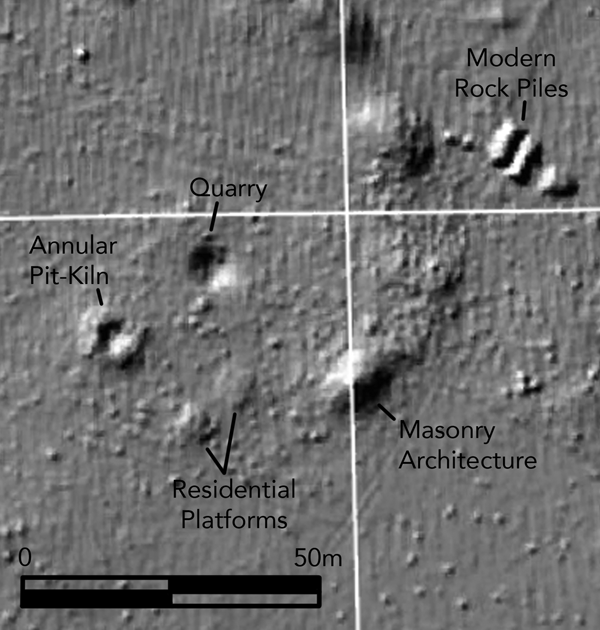
A key theme that continues to crop up in discussions of pre-Hispanic Maya lime production is the uneven survey of sites and inter-site areas throughout the Maya region. Insufficient survey coverage may even be the single most prominent factor influencing the lack of identification of lime production features in certain subregions of the Maya area. This situation is starting to change. Since 2009 (Chase et al. Reference Chase, Chase, Weishampel, Drake, Shrestha, Slatton, Awe and Carter2011), LiDAR remote sensing technology has been revolutionizing how researchers examine pre-Hispanic Maya human-environment relationships and social organization. LiDAR data has the potential to also revolutionize how archaeologists identify and study both semi-subterranean and aboveground lime production features. An ongoing research program directed by Ringle and Gallareta Negrón (Ringle et al. Reference Ringle, Negrón and Griffin2017:5) in the Puuc Region has demonstrated the feasibility of identifying Puuc annular lime pit-kilns using LiDAR data (Figure 12). The Puuc pit-kilns are indeed noticeably larger and possess a more pronounced superstructure than pit-kilns in other regions thus far identified, but the latest generations of LiDAR technology are producing ever-higher resolution images that help to identify the most minute irregularities on the surface. This will help to remove, or at least diminish, the impediment to pit-kiln identification caused by dense vegetation. Recently completed flyovers of the central and eastern Maya lowlands will provide researchers ample opportunities to scour the landscape for potential lime production features before even heading out to the field.
Detail of a LiDAR image showing the feasibility of identifying annular lime pit-kilns in the Puuc Region, as well as other archaeological features. Image courtesy of the Bolonchén Regional Archaeological Project.

LiDAR data may be particularly useful in the search for lime pit-kiln features at sites where isolated lime pit-kilns have already been identified, and thus where archaeologists have an available baseline for their perusal of LiDAR images. Fauvet-Berthelot (Reference Fauvet-Berthelot, Ichon, Percheron, Breton and Fauvet-Berthelot1980:5–7) identified a pit-kiln made up of a “pit within a pit” that dated to the Postclassic period at the site of Cauinal in Guatemala that was slightly different from the ones identified in the northern Yucatan. Similar isolated examples of this design were uncovered at Pulltrowser Swamp, Belize (Ettlinger Reference Ettlinger, Turner and Harrison1983:170–173) and possibly at Tula in central Mexico (Schreiner Reference Schreiner2002:94). Schreiner (Reference Schreiner2002:94) hypothesized that the central deeper pit would have been stacked with vertical wood fuel while the surrounding, shallower pit contained additional fuel for horizontal heat radiation. Hanson (Reference Hanson2008:1493) identified four round-bottomed pit-kilns at Ek Balam, at least one of which returned evidence of lime production. These pit-kilns appear to date to the Postclassic or Early Colonial periods. Redfield and Villa Rojas (Reference Redfield and Rojas1934:55, 64–65) identified potential lime pit-kilns while excavating at the Chan Kom in the 1930s, as well as contemporary aboveground pyres in use. Additional identifications of potential lime pit-kilns in the Yucatan have been reported by Freidel and Sabloff (Reference Freidel and Sabloff1984:35) on Cozumel, by Barrera Rubio (Reference Barrera Rubio2013) at Tizimín, and by Sierra Sosa and Martinez Lizarraga (Reference Sierra, Thelma and Ángel Martínez2013) at Chikindzonot, Cisteil, San Diego Buenavista, and Nohbec Balam in the south of Yucatan. These identifications are relatively isolated, with only one or a handful of pit-kilns identified per site. The lack of survey coverage may be the main factor limiting our ability to analyze production organization in these cases. While archaeologists continue to add new examples of pre-Hispanic lime production features to our growing catalogue, the quantity of identified pre-Hispanic lime production locales remains relatively low compared with the overall amount of lime that we know was produced from the Preclassic through the Colonial period. The continued use of LiDAR, in combination with ground-truthing, provides us like never before with the ability and opportunity to identify pre-Hispanic lime production features.
CONCLUSION AND FUTURE DIRECTIONS
This paper is a summary and analysis of past studies, as well as a call for more investigations to be dedicated to uncovering the workings of pre-Hispanic Maya lime production in the future. Considering the relative dearth of pre-Hispanic Maya lime production studies to date, each new project has the potential to exponentially increase our knowledge of the industries. In order to continue to move pre-Hispanic lime production studies forward, we encourage archaeologists to include a focus on identifying lime production features in their research agendas. There are still many gaps to fill in terms of subregions with limited attention to lime production that can contribute to a better understanding on lime production's impact on several other facets of pre-Hispanic Maya society.
Starting around 1000 b.c., the Maya began to produce burnt lime and have continued to do so for three millennia. We have outlined the difficulties of identifying lime production features in the heavily forested landscapes of the Maya area, but have also demonstrated that the task is not impossible. Permanent and ephemeral lime production features have been identified throughout the Maya lowlands, and will undoubtedly continue to be identified if archaeologists recognize the various and oftentimes-subtle features of lime production. As a central feature of Maya society, lime production is intricately connected with other societal issues, such as environmental resource management, and the functioning of local and supra-regional socio-economies. Researchers have been studying burnt lime production in the Maya area for nearly a century, but only recently have we begun to unravel the subregional variations in production. Factors such as the availability of wood fuel and the frequency of architectural features that required burnt lime appear to have influenced the types of production technologies and organization schemes employed in given subregions. Local social and economic trajectories also influenced idiosyncrasies in production strategies. In addition to these pre-Hispanic societal influences, one of the main factors affecting the current identification of discrepancies in subregional Maya lime production industries is the differential archaeological coverage for different subregions of the broader Maya area. Remote sensing technologies and LiDAR, in particular, provide an invaluable tool for examining the various forms and organizations of pre-Hispanic lime production. We hope that archaeologists will continue this momentum and devote a greater focus to understanding Prehispanic Maya burnt lime industries for their own sake, as well as for providing a greater understanding of the various other societal features with which they are intertwined.
RESUMEN
La cal ha sido un material crucial en la vida de los mayas al menos desde el 1100 a.C., continuando hasta nuestros días. Sin embargo, su naturaleza efímera ha limitado los estudios arqueológicos sobre su producción y distribución. El uso en décadas recientes de nuevas tecnologías tanto en el registro y la excavación arqueológica, así como la magnitud de los salvamentos arqueológicos ha permitido entender a mayor profundidad la industria de la piedra caliza.
Tradicionalmente, gracias a estudios etnoarqueológicos y etnohistóricos se ha propuesto el uso de piras superficiales para producir cal en tiempos prehispánicos; otro aspecto importante que respalda esta hipótesis son los experimentos de construcción y calcinación de piras con el objetivo de cuantificar la cantidad de cal así como el tiempo de trabajo invertido por los artesanos para obtener el material necesario para la construcción de las estructuras que perduran en las ciudades Mayas; los estudios a partir de los estucos y morteros se han utilizado para correlacionar la producción y manejo de la cal en tiempos prehispánicos.
Con base en los datos experimentales y un estimado de la cantidad de material utilizado en la construcción de los edificios de las ciudades mayas se ha propuesto que la producción de cal fue una de las causas de deforestación en el área maya, que contribuyeron al colapso de la sociedad maya. Gracias a los nuevos hallazgos en las regiones de Oxkintok, Kiuic y Dzibilchaltun, en este artículo proponemos que no solo se cuenta con una industria, sino con varias industrias regionales de producción de cal en el área maya.
Esta propuesta surge a través de la revisión de los datos actuales incluyendo la identificación reciente de los hornos para cal en el norte de la península de Yucatán. Asimismo, discutimos las ideas sobre el manejo de los recursos medioambientales y las relaciones socioeconómicas en las cuales los estudios sobre la producción de cal tienen un potencial para aportar datos. Utilizando los datos recuperados hasta ahora como línea de base, presentamos un análisis de los factores que influyen en el desarrollo de distintas industrias subregionales de producción de cal. La identificación de las discrepancias en la tecnología y la organización de la producción se debe a factores como la variación en: los requisitos de consumo de cal y el espaciamiento entre sitios; entorno natural; trayectorias sociales y económicas locales; y, los objetivos y los universos de investigación arqueológica.
Nuestras investigaciones nos permiten proponer en este momento que la organización de la producción de cal fue llevada a cabo por especialistas. El conocimiento tecnológico para producir la cal, para construir una pira o un horno, para manejar el fuego, para realizar la extracción de la caliza adecuada para ser calcinada hace necesaria la presencia de especialistas en cada paso del proceso productivo. Somos conscientes que nuevos hallazgos e investigaciones en diversos sitios del área maya podrán corroborar o refutar nuestras propuestas. Finalmente alentamos a los arqueólogos a incluir un enfoque sobre la identificación de rasgos de producción de cal en sus proyectos de investigación y contribuir al entendimiento de las relaciones socioeconómicas, medioambientales y productivas que los Mayas mantuvieron con la cal.
ACKNOWLEDGMENTS
We would like to thank Tomás Gallareta Negrón, George J. Bey III, Bill Ringle, Rossana May Ciau, Evan Parker, Betsy Kohut, Maggie Morgan-Smith, Tomás Gallareta Cervera, and Tom Garrison for their help and support over the years. Thanks to Sarah Clayton, Nam Kim, Mark Kenoyer, William Aylward, Steve Weiner, Michael B. Toffolo, Eunice Uc Gonzalez, Alfredo Barrera Rubio, Carlos Peraza Lope, Raul Morales Uh, Silvia Estrada Vielma, Ángel Góngora Salas, Susana Echeverría Castillo, Fátima Tec Pool, Dalia Paz Rivera, Alejandro Mitrani Viggiano Nora A. Pérez, and José Luis Ruvalcaba Sil for their guidance and comments.