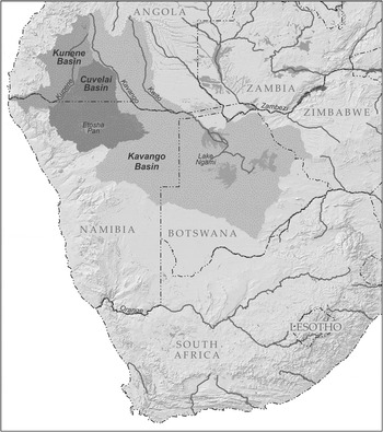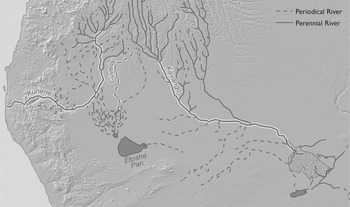


In the late 1840s and early 1850s, visitors from western Europe and North America began arriving in the triangle of land bounded by the middle and lower courses of the Kunene and Kavango rivers and interlaced with the internally draining Cuvelai system (Fig. 1). These new arrivals were diverse in their nationalities and in their reasons for travel, but they were united in their quest to incorporate this space into their field of knowledge and in seeing water as central to this quest. Water was important for the simple reason that there was so little of it. The next perennial river, the Orange, lay 700 miles to the south and flowed through desert and semi-desert. Indeed, the triangle of land between the Kunene and Kavango rivers marked the southern limit of non-irrigated agriculture on the western side of the continent. Only with the seventeenth-century arrival of Dutch sailors and Mediterranean crops at the Cape of Good Hope, more than 1,000 miles away, had agriculture gained another foothold in southwestern Africa.
The watersheds of the riparian region.

The presence of flowing water held potent meanings for both local inhabitants and their new visitors, but those meanings differed. In regional political cosmologies, rain that fell and water that flowed permitted the creation of settled agro-pastoral zones that contrasted with the wilderness beyond. Water, the fertile soil it carried, and kingship all originated in the rainy north. The physical features of the landscape were thus entangled with a landscape of political and ritual power. For northern European travelers arriving from the arid south, flowing water contained the promise of desires fulfilled: trade and evangelism in sedentary, densely-populated societies and, later, the resources to develop a prosperous settler colony.
This article explores the collision of these competing meanings of water along what are now the borders of Namibia, Angola, and Botswana in the latter half of the nineteenth century. John Noyes, speaking of the production of ‘colonial space’ in German South West Africa, argues that
the traveling looker and writer develops strategies for rendering the world habitable … [through] strategies for mapping universal principles onto specific objects apprehended in vision. The specificity of these objects must be negated in order that they may be integrated into a system of universal knowledge.Footnote 1
Ultimately, this is what happened. These waterways are now included in maps that denote this ‘universal knowledge’. Such maps portray the watersheds of discrete river systems and their relationship to national borders. They demarcate a clear separation between these basins that is invisible to the naked eye. These maps look the same, whether one consults them in Namibia or the United States, Angola or China.
Much of the literature on the history of exploring, mapping, and surveying what became European colonies focuses on this outcome – the incorporation of unique spaces into imperial knowledge systems and the concurrent negation of locally specific knowledge. Maps convey ideological and politico-economic messages and help construct the geographical features they purport to represent. Nineteenth-century improvements in technologies of scientific measurement did not change this: ‘Far from being incompatible with symbolic power, more precise measurement intensified it. Accuracy became the new talisman of authority.’ Scholars agree that maps were central to the creation of empire. They were a means of domination – a tool wielded by the powerful. But this begs the question of who has power and in what contexts.Footnote 2
Maps did eventually demonstrate the conceptual, if not physical, mastery of Europeans over African space. A complex and diverse waterscape was simplified into a series of blue lines denoting ‘rivers’. Fig. 1 represents the culmination of this process. This article begins with an earlier moment, when Europeans first began to penetrate that space. I am interested in what came before the maps could be drawn – the first, physical act of seeing and its translation into writing, those moments when rivers were ‘apprehended in vision’. As these new arrivals gazed upon a physical land- or waterscape for the first time, what mediated their visual encounters with the African environment, prompting them to describe what they saw in particular ways? And how did those descriptions seep into atlases that were, by the latter nineteenth century, ‘manifestos for the new brand of scientific objectivity’?Footnote 3
The cartographer James MacQueen argued in 1826 that, ‘Till a European … ascertain all these points from ocular demonstration, and with scientific precision, the public mind will not be satisfied.’Footnote 4 Vision, Matthew Edney reminds us, was assumed to offer access to ‘a pregiven world of independent truth’.Footnote 5 But, Europeans routinely reported things they did not see with their own eyes. They approached flowing water, traveled along it as far as they were able or permitted to go – which generally was not very far – and filled in the blanks based on information from local inhabitants, the often-ambiguous accounts of previous travelers, and their own perception of what made sense. The resulting maps obscure the distinction between what was seen and what was heard, imagined, or speculated.
Visitors to the riparian triangle struggled to meld their own conceptions of how water behaved, what appeared in their field of vision, what earlier maps conveyed, and what they desperately wanted to see with the information that local inhabitants conveyed. They gazed at flowing water and speculated about how different waterways were connected and what futures this water might make possible. It was not easy in this context to negate specificity. The way that water moved across the flat landscape and the variability of its flow challenged these outsiders’ cognitive geographies, the categories and mental maps by which they made sense of the physical world around them.Footnote 6
This article explores the alchemy whereby ritual and political worlds invisible to Europeans were nevertheless rendered visible on maps that purported to represent only observed physical reality. The possibility that local cognitive geographies influenced how Europeans apprehended and mapped a place has been underemphasized in the literature on cartography. Edney states that ‘traces of local knowledge and of the manner of its acquisition can occasionally be discerned’, and cites orthography as a case in point without elaboration.Footnote 7 But what happened in the riparian triangle was much more fundamental to the process of knowledge production, and traces of it survived into the middle of the twentieth century.
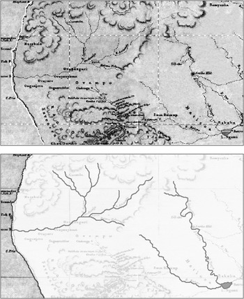
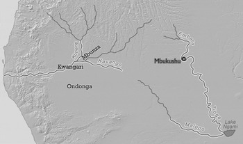
I begin by contrasting Europeans’ perspectives on this waterscape with regional political ecologies. I then turn to two case studies of riparian mapping: confusion over the identity and course of the Kavango River and the late ‘discovery’ and mapping of the ‘Cuvelai River’ in the 1950s. The sources for each case are early travelers’ accounts and colonial archives – as well as the maps informed by those written sources. Jean Aroom, a Geographic Information System specialist, georeferenced these older maps, removing distortions and aligning them with a modern base map. This allows comparison of historical maps with one another and with a scaled representation of these watersheds today, as demonstrated in Fig. 2, which shows how the georeferenced 1852 map in Fig. 4 was created from the historical map.
The 1852 map representing the journeys of Andersson and Galton, and Livingstone, top, is overlaid with modern data to show the placement of key features on the map. Most of the map's details are eliminated to highlight the rivers on the map. The result is shown in Fig. 4.

The georeferenced maps reveal patterns in early representations that are obscured in the proliferation of detail and imaginative spelling on the originals. They show how cartographers translated travelers’ words into space. They raise questions about why people visualized things as they did, and contain clues to what the answers might be. On these maps, the Kavango River is hyper-visible. It appears on every map, often in the form of more than one stream, sometimes flowing in more than one direction. The Cuvelai, by contrast, is invisible. The perennial stream, lagoon, and seasonal drainage channels that form this complex drainage system – a system that sustained half of Namibia's population until recent decades – are absent. This riparian visibility and invisibility mirror the fate of two kingdoms, Mbukushu and Evale, situated at strategic points on each river. They were comparably sized polities whose royal clans were regionally famed for their powerful rainmakers. While Mbukushu appears on virtually every nineteenth-century map of this region, Evale appears on very few of them. In the late nineteenth century, the Mbukushu ruler's ritual authority over water was unchallenged and formed the basis for claiming new kinds of power, while the ruler of Evale found himself isolated from new trade networks and subordinated by larger, militarizing kingdoms that ignored Evale's ritual importance. The georeferenced maps help us to see how these local geographies of power were transmitted to foreign travelers who were oblivious to them.
European representations of South West Africa's hydrology and geography thus reflected more than foreign categories of knowledge ill suited to the region's waterscape. They incorporated local debates over the nature of legitimate political authority. Forced to rely on African informants to construct a holistic view of the waterways they encountered, Europeans unwittingly wrote into the archival record the priorities and views of their interlocutors and local elites. These visitors, who saw themselves as bringing the legacy of the Enlightenment to the African continent in their quest to cognitively conquer the region, for whom the map represented a crucial step in that conquest, would have been shocked to hear that they were mapping shifting relationships of rainmaking and ritual authority. But that is what they were doing.
SEEKING WATER: THE POETICS AND POLITICS OF THE HYDROSCAPE
Europeans came relatively late to these rivers. The earliest written account of travel from the north, by the educated sertanejo Bernardino Brochado, recounts an 1850 journey that took him to the Kunene River, across the triangle of land between the Kunene and Kavango, and down the Kavango to its confluence with the Kwito.Footnote 8 From the south, David Livingstone and two British companions arrived at Lake Ngami, part of the Kavango River's inland delta, in 1849, but did not realize the lake was the terminus of a river. Two years later the explorer (and later eugenicist) Francis Galton and the Swedish hunter and trader Charles John Andersson were the first Europeans to travel to the Cuvelai floodplain from the south, guided to the kingdom of Ondonga by Herero traders.Footnote 9 The Swedish naturalist Johan August Wahlberg and the Canadian-born hunter Frederick Green traveled upstream and overland from Ngami to the Mbukushu capital in 1855, while Green was celebrated as the first European to reach the Kunene River from the south, in 1866.Footnote 10 By the late 1860s, white and mixed-race South Africans, Europeans of various nationalities, and the occasional North American were moving into the riparian zone from the south with more frequency, exchanging firearms, gunpowder, horses, and consumer goods for ivory and cattle.Footnote 11 Missionaries came too, settling in the southern part of the Cuvelai basin in the late 1860s and in the northern part by the 1880s.Footnote 12
As they moved northward from the Cape, missionaries, hunters, and settlers encountered increasingly arid environments, while those who began at Walvis Bay could access the interior only after crossing nearly 100 miles of the coastal Namib Desert. South of the riparian zone, all travel was subordinated to the geography of waterholes and the timing of the rainy season, and written accounts are replete with horrific tales of oxen dying of thirst in their yokes and of travelers going days without access to water. When Africans wanted to deter European travelers, they most commonly resorted to telling them there was no water ahead. Matters were very different for those traveling in what is now Angola where – except for the southern coastline – flowing water and abundant rains were the norm. Rivers appear in early Portuguese reports merely to orient the reader to the human settlements along them or to demonstrate the difficulty of travel, with its endless crossings at fords and on rickety bridges.Footnote 13
Foreigners from the south had a very different response to encountering water. For these travelers, flowing water was the sound of home. Livingstone, seeing the Botletle River flowing out of the Okavango Delta, compared its banks to ‘the River Clyde above Glasgow’.Footnote 14 Andersson, crossing the Kavango in a canoe in 1859, wrote, ‘After traversing for so many years the eternal “deserts” of Damara and Namaqua Land, the sight of so much water was naturally very welcome.’Footnote 15 The American trader Gerald McKiernan, pausing along a spring-fed creek in the Waterberg plateau in 1875, wrote, ‘That night I camped within the sound of rushing water and was reminded of my own native Alleghanies.’Footnote 16 The Swiss botanist Hans Schinz, arriving at the banks of the Kunene River in 1885, noted that he was ‘moved’ by the sight: ‘[I]t is the first stream, the first flowing water, since I left home more than year ago’.Footnote 17 These travelers, marveled at the dramatic contrast between these riparian lands and the arid lands to the south, and at the seasonal transformation of dry lands and narrow streams into lakes and lily-filled lagoons.
These were the esthetics of seeking and seeing rivers: the desire for something that could domesticate a harsh and alien world. But, to the people who inhabited the riparian triangle, the waterscape and sedentary communities that enchanted newcomers were not a geographical accident. They were the product of human intervention into cosmological forces, and some people had more power over those forces than others. In agricultural communities from south-central Angola to the Okavango Delta, political authority was grounded in ritual power, particularly over water and fertility. By the mid-nineteenth century this power was concentrated in lineages claiming immigrant status, their authority tied to purported origins in northern, well-watered environments.Footnote 18 Along the Kavango, royal clans claimed descent from groups who lived along perennial rivers in what is now southeastern Angola and southwestern Zambia.Footnote 19 In the Cuvelai floodplain, most polities were governed by royal clans who variously claimed to have migrated from the banks of the Kunene, the Kavango, or the kingdom of Evale, along the perennial portion of the Cuvelai River.Footnote 20 Communities along the non-perennial stretch of the Cuvelai river system and pastoralist communities along the lower, arid reaches of the Kunene sent tribute to these upstream ‘origin societies’ in exchange for rain.
This logic of northern, immigrant power over water was grounded in the same physical environment whose contrasts so forcefully struck European travelers. Rainfall in this region is highly variable and diminishes rapidly as one moves south and west. The lands of the riparian zone were (and are) marginal for agriculture and vulnerable to drought. To the south are lands suited only to pastoralism, hunting, and gathering. But to the north are the rain-rich lands where rivers are born. The seasonal flood regimes of these rivers were crucial to the existence of sedentary societies in the Kunene, Cuvelai, and Kavango basins. The infertile Kalahari sand that blankets much of southwestern Africa was interrupted here by zones of comparatively fertile alluvial soil. These soils permitted floodplain farming along the Kavango River when the rainy season ended and created pockets of resources that otherwise could not exist, such as reeds, fish, and dry-season grazing. In the triangle of land between the Kavango and Kunene rivers, seasonal inundations fed partly by higher rainfall in the Angolan highlands and partly by local rains flowed slowly across the flat landscape in broad channels known as oshanas, recharging shallow aquifers and nurturing large quantities of fish.Footnote 21 This vast alluvial fan is linked to a semi-perennial river upstream called Cuvelai, and the oshanas downstream are known today as the Cuvelai delta. Perhaps one year of every three or four on average, when rainfall is heavy in Angola, the delta drains into the Etosha Pan at the southern end of the basin – an event known locally as the efundja.
In the 1860s, Andersson observed that Cuvelai communities held rainmakers ‘in high honor and repute’.Footnote 22 The most powerful rainmakers were located along perennial rivers, often in the same societies where local royal clans claimed their origins. In the western Cuvelai floodplain, kings sent tribute to Nkumbi rainmakers who lived along the Kunene River. In the eastern floodplain, rainmakers were sent to the kingdom of Evale, located where the Cuvelai River enters a shallow lake before becoming a seasonal stream and branching into a network of oshanas. In the southeastern Cuvelai floodplain, as well as along the Kavango River, its inland delta, and even along the middle Zambezi, communities and kings paid tribute to the Mbukushu ruler, or fumu, in exchange for rain.Footnote 23
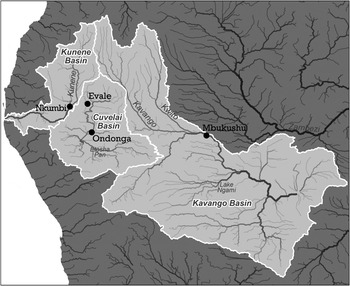
The relationship between rain and flowing water in local epistemologies is not easily recovered today. But the most potent regional rainmakers – the rulers of Nkumbi, Evale, and Mbukushu – all resided at nearly the precise point below which arid conditions meant no more water was added to a river via perennial tributaries (Fig. 3). Their regional status as powerful rainmakers gave their tiny polities disproportionate power and influence and allowed their rulers to collect large quantities of tribute from more populous and militarily powerful communities.Footnote 24 The correlation between residence in a water-rich place and the power to call more water – to make rain – was implicit and explains why claiming origins in a well-watered, rainy place was crucial to claiming certain kinds of legitimate political authority in the region's centralizing societies. Royal power, like rain and river water, flowed from wet to dry environments.
Rainmaking societies in the riparian region, as well as the kingdom of Ondonga, which was not famed for rainmaking but is present on virtually every map from this time. Nkumbi, Evale, and Mbukushu are located on perennial streams. Nkumbi and Mbukushu are located close to the junction of major tributaries with those streams. Except for the Kunene and Kavango themselves, virtually every watercourse located south of these rainmaking societies is intermittent, and some are dry for years at a time.

In this view of the world, the forces that dictated the presence or absence of water on the land amounted to far more than rainfall and topography. The cognitive geography that emerged out of this environmental context linked peoples and communities across vast distances through flowing water and rain, which were fundamental to people's relationship to others. The dual meanings of the English term ‘tributary’ – a stream that flows into a larger river and a political unit or person who pays tribute to another – were, in this place, far more than linguistic concurrence. They were a major component of the region's political ecology.
The newcomers from the south were oblivious to this political ecology, but they had their own. Enchanted by the esthetics of these waterscapes, they were also part of an expanding capitalist world. The early stages of European exploration from the south focused almost obsessively on finding ‘highways’ into the interior: water routes that would circumvent hostile groups, save travelers the hardship and heartache imposed by treks through the ‘thirstveld’, and offer economical ways of getting products in and out of a densely populated area. Brochado offered a few perfunctory comments on the suitability of the rivers he encountered for navigation and noted the reported existence of a mighty river to the east (the Zambezi). But writers from the arid south fixated on the idea of ‘networks’ of rivers. Livingstone and his companions, asking Yeyi inhabitants south of the Okavango Delta for the origin of the stream that fed Lake Ngami, were told it came ‘from a country full of rivers – so many no one can tell their number’. The response prompted Livingstone to dream of ‘a highway capable of being traversed by boats to an entirely unexplored and very populous region’.Footnote 25
The physical environment nurtured such fantasies. The annual floods, which transformed rivers in the flat landscape from ribbons of water into sheets of water, seemed to hold out the promise of navigation deep into the interior. But explorers could rarely persuade African rulers to allow them to seek these fabled rivers, and so they relied on local informants in their quest to add water to the blank spaces on their maps.
LOCATING WATER IN SPACE: SEEING AND MAPPING THE KAVANGO RIVER
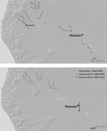
The Royal Geographical Society's 1852 map based on Galton and Andersson's trip to the Cuvelai basin and Livingstone's visit to Ngami filled in one of those blank spaces (Fig. 4). The map contains two rivers associated with the modern-day Kavango. The first is a westward-flowing tributary of the Kunene, labeled as the Kavango River, with the Kwangari and Mbunza communities on its banks. The other, to the east, is labeled Embarrah, has the Mbukushu kingdom on its banks, and flows southeast to Lake Ngami. Maps in atlases from 1858 through 1875 largely replicate this waterscape: the ‘Kavango’ is assumed to be a tributary of the Kunene while the ‘Embara’ – sometimes labeled ‘Tioge’, a local name for the stream that fed Lake Ngami – flows southeast into the lake (Figs. 5–7).
Source: F. Galton, ‘Recent expedition into the interior of south-western Africa’, Journal of the Royal Geographical Society, 22 (1852), 140–62.

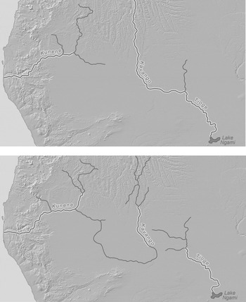
(top) source: H. Kiepert and C. F. Weiland, Grosser Hand-Atlas des Himmels und der Erde (Weimar, 1871); (bottom) sources: J. H. Colton, Colton's General Atlas (New York, 1860); J. H. Colton, Colton's General Atlas (New York, 1870).

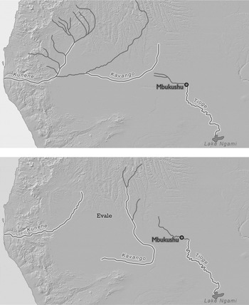
(top) source: J. Bartholomew, The Handy Atlas (Chicago, 1871); (bottom) source: J. Bartholomew, Philips’ Handy General Atlas of the World (London, 1874).

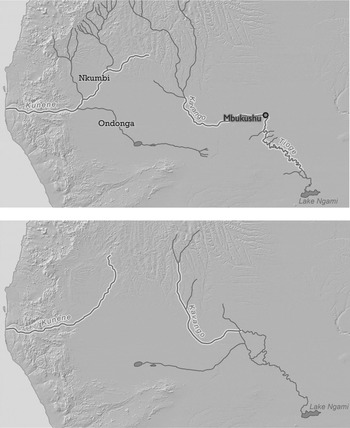
(top) source: F. von Stülpnagel, Adolf Stieler's Hand-Atlas über alle Theile der Erde und über das Weltgebäude, 4th edn (Gotha, 1864); (bottom) source: A. Petermann, Adolf Stieler's Hand-Atlas über alle Theile der Erde und über das Weltgebäude, 6th edn (Gotha, 1875).

These maps embed African notions of power in European cartographic space. Each feature on the maps tells its own story, but perhaps the most obvious is Mbukushu. In maps from the 1850s through 1882, it appears more frequently than any other polity except Ondonga, which was a large kingdom that became the headquarters of both European elephant hunters and Finnish missionaries from the south.Footnote 26 What is now called Mbukushu, below the confluence of the Kavango and Kwito rivers, straddled the rockiest and narrowest portion of the Kavango River. It was the smallest of five clustered polities. The other four polities, when they appear on early maps at all, are sited far away, along other watercourses. Mbukushu, unlike every other community on early maps of the region, appears not under the collective name by which it was later known but by Libebe, the name of the reigning monarch or fumu. The spellings and locations vary, but very few maps from the time omit the Mbukushu kingdom and its ruler's name.
There is little in travelers’ accounts to indicate why they concluded that ‘Libebe’ was the dominant polity or ruler along the river that fed Lake Ngami. While Ondonga assumed its place on maps because so many Europeans went there, very few people from the Cape visited Mbukushu prior to the early 1900s. But they heard a great deal about it. Rulers of large states located from the Zambezi to the Cuvelai plain reported to travelers that Libebe was a powerful rainmaker. Some said that he controlled the flow of the river itself. He was, one European hunter concluded, the ‘God of the waters’.Footnote 27 A man living many miles downstream from Libebe told Frederick Green of bringing him tribute and witnessing the rainmaker actually create the flow of the river.Footnote 28 In Angola, the missionary Charles Duparquet wrote that the fumu, ‘it is said, is full of power over the rain of heaven that he can drop or stop at his discretion’; he received presents from Cuvelai kingdoms and the Batawana state south of the Okavango Delta, ‘in order to obtain the fertility of the country’.Footnote 29 The British explorer and hunter Alfred Gibbons observed that Kololo and Barotse kings had for at least half a century sent tribute to the fumu in exchange for rain.Footnote 30 And Aurel Schulz and August Hammar, traveling the region in 1884, called the Mbukushu fumu ‘king of the Okavanga’ [sic].Footnote 31
In the 1850s, Libebe was positioned to combine the advantages of ritual power and access to expanding long-distance trade routes.Footnote 32 Sitting below the junction of the Kavango and Kwito rivers, the Mbukushu kingdom was a stopping point for long-distance traders from the north despite its rather small size. There were no dramatically larger population centers nearby to serve as competitors, and travelers from the Cape noted the presence of Portuguese-based trade there in 1852. Its proximity to elephant hunting grounds also attracted foreign hunters and traders. In 1855, Wahlberg and Green observed large quantities of goods – beads, firearms, and ammunition – obtained through northern trade routes.Footnote 33 Libebe regulated this commerce within his kingdom, threatening with death any subject who traded directly with foreigners.Footnote 34
Europeans following the Kavango River from both the north and the south found themselves able to get as far as the Mbukushu kingdom and no farther: the fumu refused to allow them to proceed. Wahlberg and Green were forbidden to continue upstream – or to meet Libebe himself.Footnote 35 Travelers relied on their African interlocutors to explain Mbukushu's place in the larger hydroscape. Residents of Lake Ngami seem to have told foreign visitors, including Livingstone, that the river stretching north of the lake was called Embarrah or Embara, the dominant name on maps for more than two decades. It bears no resemblance to any other known local name for the river or to any term for flowing water. Instead, it is probably a rendering of mbara, the thiMbukushu word for palace or capital – further evidence that people to the east and south of the Mbukushu kingdom linked the river's existence to the Mbukushu royal family.
The image of ‘networks of rivers’ in the interior combined with stories of Libebe's reputed power over water to foreclose other possibilities – including the correct geography established in 1850 by the Portuguese explorer Brochado (and confirmed by later Portuguese travelers from the north). On the resulting maps, the river that fed Ngami and the Mbukushu kingdom were synonymous.
The power of the association between the river and the rainmaker king endured even as Europeans encountered different sections of the river, because they did so through overland journeys, not by following the waterway itself. Four years after Green and Wahlberg found their journey terminated on Libebe's orders, Andersson hired guides in the south to take him not to the river Green and Wahlberg had visited but to the fabled Kunene, to the northwest. To Andersson's confusion, the guides took him northeast. When those guides reached the limits of their geographic knowledge, Andersson proceeded to kidnap Bushmen and force them to serve as guides. He followed a dry riverbed northeast, striking the Kavango more than sixty miles upstream from the Mbukushu capital.
Andersson paused at the banks of a river that he assumed was a westward-flowing tributary of the Kunene. ‘I had stood for some time by the water before I became aware of my mistake. “By heavens!” I suddenly exclaimed, “the water flows toward the heart of the continent instead of emptying itself into the Atlantic!”’ His realization forced him to reconceptualize his imagined geography of the region. He considered and rejected several theories – including the possibility that the river flowing past Libebe's palace and that at which he now stood were one and the same, despite the fact that he encountered Mambari traders making their way along the river to the Mbukushu capital. He concluded: ‘I strongly question the correctness both of my own impression and of the account of the natives.’Footnote 36
Seven years later, in 1866, Green finally reached the Kunene's wooded banks just north of the contemporary Namibia-Angolan border and described it as ‘a pleasing contrast to most parts of the Okavango’, with its slow current and cultivated banks. But Green continued: the Kunene instead resembled the narrow and rapid river flowing past the Mbukushu kingdom, a river ‘that will never disappear from my memory’. Green remained convinced that the Kavango and the stream flowing past Libebe's palace were two separate rivers. Certain that the upper Kavango was a tributary of the Kunene, Green asked his readers: ‘The Cunene is, I think, unquestionably in some connection with the latter river. Cannot the Okavango be a branch of the Cunene, although it flows eastward and the latter westward?’Footnote 37
Maps from the 1860s and early 1870s show how cartographers sought to render these possibilities in spatial terms. Most show the Kavango flowing into the Kunene. (see Fig. 4; Fig. 5, top map; Fig. 6, bottom map; Fig. 7, top map) One cartographer created two parallel rivers flowing south – one labeled Kavango and a second with Mbukushu on its banks (see Fig. 7, bottom map). Another map shows a separate river for the Mbukushu kingdom that feeds into a larger river, thereby resolving Andersson's dilemma of two apparently separate rivers flowing southeast (see Fig. 5, bottom map). The 1871 map does something similar but has the honor of being the first to orient the Kavango River correctly (see Fig. 6, top map). Yet three years later, the same mapmaker returned the Kavango to its status as a Kunene tributary. He did so, however, in a way that resolved Green's paradox of the southeastward flowing Kavango being ‘in some connection’ with the westward-flowing Kunene: the Kavango is shown flowing south and slightly east before looping to the west to join the Kunene – a remarkable course for terrain with no perceptible elevation changes! (See Fig. 6, bottom map.) This idea was borrowed with less confidence by Stieler's Handatlas in 1875 (see Fig. 7).
The physical properties of the Kavango itself were one source of confusion. The terrain around it changed dramatically: wide and broad upstream, it was a rocky, narrow river studded with islands and cascades near the Mbukushu capital. Travelers proved unable to gauge a river's volume of flow through observation alone. Andersson, on the banks of the Kavango, had called it a ‘truly noble river’, noting it was 200 yards wide and could not be the narrow, rapid stream that flowed below Libebe's palace: ‘That channel alone is much too insignificant to form the outlet for such a mighty flow of water.’Footnote 38 Green agreed. (In actuality, the Kavango nearly doubles in volume between where Andersson stood and the Mbukushu kingdom, because it merges with the equally large Kwito river along the way.)
It may seem that it took less imagination to visualize a broad, shallow, and slow river becoming a narrow, deep, and fast-moving river than to visualize the confluence of two rivers that flowed away from each other. But the role of the Mbukushu rainmaker-king in local geographies shaped outsiders’ sense of the possible. When Andersson stood on the banks of the eastward flowing Kavango, trying to understand how it might relate to other rivers, his assessment of the possible options was constrained by local assertions that the region's water supply originated with the Mbukushu fumu. Visitors assumed that the river that flowed past Libebe's palace originated in his territory. Andersson also knew that Livingstone – whom he revered – had placed on a map of the region ‘a river as coming from Libebe toward Sekeletu's town’ to the east – the ruler of the Kololo, a major client of the Mbukushu king's rainmaking services.Footnote 39 In local conceptions, this represented in liquid form the lines of material tribute and rain that passed between the Mbukushu and Kololo community. Neither Livingstone or Andersson necessarily connected the purported existence of such a river to Libebe's rainmaking powers. But this information led Andersson to imagine that the river he stood on was somehow connected to the Zambezi.
It took another twenty years – during which Europeans were refining their maps of Africa – for maps of this region to begin to reflect Euclidian space rather than African political ecology. European elephant hunters ranged in the dry lands south of the Kavango River, but few ventured to Libebe's palace, where tsetse fly plagued their horses and cattle and where European visitors were often coolly or even hostilely received. Without direct European confirmation of the river's course, maps were left unchanged. Only in 1882, three years before the Kavango came to delineate the border between the territories claimed by Germany and Portugal, were the two halves of the Kavango River definitively united (Fig. 8). And yet, puzzlement over the logic of the river's course clearly remained (see Fig. 8, bottom map).
(top) source: W. G. Blackie, The Comprehensive Atlas and Geography of the World (London, 1882); (bottom) source: H. Berghaus, Adolf Stieler's Hand-Atlas über alle Theile der Erde und über das Weltgebäude, 7th edn (Gotha, 1882).

In subsequent maps of the region, accuracy generally improved and the number of places ‘marked’ on the map multiplied rapidly – the latter proceeding at a faster pace than the former. And yet there remained a striking absence. The Cuvelai drainage system, which operated independently of both the Kunene and Kavango rivers and which enabled the existence of the very agricultural communities that had enchanted Europeans arriving from the south, is nowhere to be found.
THE DISCOVERY OF THE ‘CUVELAI RIVER’
For people who lived along them, rivers were not important in their entirety. People could – and did – describe watercourses for many miles upstream and downstream with fair accuracy. But viewing a river as a singular, bounded entity distinct from all others – as a highway, for example – was not part of the cognitive world of southwestern Africa's riparian communities. When people spoke of their place in the land- and waterscape, they often referenced adjacent stretches of several separate river systems. People along the Kavango told Brochado about the Zambezi, while those in Ondonga described both the middle Kunene and the middle Kavango to travelers from the south. But the word ‘river’ in these accounts surely conflates multiple words for flowing water. When Livingstone's informants at the southern edge of the Okavango Delta attempted to draw him a picture of multiple ‘rivers’ in the north, did they mean the tangled channels of the Delta itself, or did they mean the Zambezi, Kavango, and their major tributaries?
Ritual power crossed watersheds. Residents of the western Cuvelai floodplain sent for rain to the Kunene; people in the Ondonga kingdom claimed that their royal clan originated from the Kavango's banks. Kavango polities, meanwhile, had multiple migration traditions that linked them to different rivers: the Kwito, the Okavango Delta, and the Zambezi and its tributaries. The name of a single waterway changed over its course and reflected local community identities, but European visitors viewed a river as a single, bounded entity. This was no more ‘true’ a view than the local approach: every river is a series of tributaries, feeding into each other. Calling the result one thing privileges the contributions of one line of tributaries over all the others, in much the same way that following a single line on a family tree obscures the contribution of countless other branches.
Paradoxically, local specificity was sometimes rooted in generalization. There were stock sets of descriptive names for streams – names that Europeans took to be proper nouns. The 1852 map drawn on the basis of Livingstone's visit to Ngami featured the ‘River Malopo’ branching west from the lake and fed by another tributary labeled ‘River Omoramba’ (see Fig. 4). Molapo is Setswana for a dry watercourse and omuramba is its Otjiherero equivalent. Places that contained water often bore names drawn from the root – val, or water-loving palm trees; Evale was just one example of this. The Swedish army officer Peter Möller recorded the name of a Kunene tributary as Kalonga, which is the diminutive of omulonga, the local word for perennial or nearly perennial stream.Footnote 40 The same stream's name changed to Oshitanda (rendered on some maps as Achitanda, see Fig. 5) when it cut through ‘broken’ country so rugged Möller could no longer travel along its banks.Footnote 41 Okutanda means ‘to cut’, indicating that this too was a descriptive name.
The meeting of European and African ways of looking at the waterscape thus opened up a vast terrain of potential miscommunication. The multiplicity of names Europeans were offered made it impossible to know, without following the entire course, which names denoted a single, continuous waterway, and this confusion is reflected in the maps. But limited visual encounters and local naming practices were not the only sources of confusion. A much more fundamental problem of translatability was also at work. The languages of this region provide distinctive names for seasonally dry channels that add water to a river, perennial rivers, and seasonally dry channels that distribute floodwater across the landscape. Local complexity gave way to simplification when outsiders encountered these physical features. They sometimes adopted the local word for a seasonal stream, omuramba, and for a drainage channel, oshana. But they blurred the lines between these indigenous categories as they struggled to understand and describe what they saw.
The contrast between local and outsiders’ cognitive geographies was greatest in the space between the Kavango and the Kunene. When Galton and Andersson arrived at the southern edge of this region in early June 1851, about a month after the rainy season had ended, they were shocked and delighted at ‘the beautiful and fertile plains’, with neat dwellings tucked amid fields of grain – ‘a perfect Elysium’ compared to the dry lands to the south.Footnote 42 Later travelers echoed these impressions.Footnote 43 The contrast with the arid south was fundamental to local communities’ identities as well: agricultural communities that benefited from flowing water distinguished themselves and their sedentary neighbors from the hunter-foragers and herders who lived in the dry lands beyond.
But the newcomers from the south were clueless as to what made this distinction possible: an extensive system of natural drainage channels that flow across the flat plains during the rainy season, starting at the southern end of the Angolan highlands between the Kavango and Kunene watersheds, and ending at Etosha Pan in years of heavy rainfall. Modern maps represent these channels as the Cuvelai basin, river, or delta. But for decades, there was no Cuvelai on maps of the region. In 1882, two different maps reached two different conclusions about the source of the water that appeared in Etosha Pan, the major terminus of the Cuvelai system. One connected it to the Kunene River and the other to the Kavango River (see Fig. 8). As late as 1924, two German farmers giving evidence to a drought commission differed on the direction the stream on the bottom of Fig. 8 flowed. One insisted it fed Etosha Pan, the other that Etosha Pan fed the stream.Footnote 44
Brochado, the 1850 Portuguese traveler, did not ‘see’ a river here either. But although he lacked a single term to encompass what he saw, he did manage to describe the region's hydrology with striking accuracy. He wrote that in this region, ‘There is nothing special except the big lagoon [that forms the] outlet of the [river].’ He termed this ‘lagoon’ Var, the same name he used for the adjacent kingdom of Evale, and noted its crucial importance to the people and water infrastructure below. During the rainy season the ‘Var’ overflowed, ‘its waters flooding that land’, filling ponds, wells, and waterholes with water and fish that lasted until the next rainy season.Footnote 45 Brochado's thorough description of the full annual cycle of rainy and dry seasons and the associated hydrology indicates that his knowledge came from local informants, not his own observations during a brief visit.
Contrast this description to that of Möller nearly a half-century later. Ondonga, in the southern part of the Cuvelai Delta, had become a gathering place for white hunters and traders from the south. Möller traversed nearly the full length of the Cuvelai system, and assumed that the water in the ‘lagoons’ near Evale was connected to the Kunene.Footnote 46 The belief that the region's oshanas were part of the Kunene system persisted for decades.
The confusion of southern travelers was due in part to the nature of the land itself: it was so flat that its gradient took decades to be worked out by professional surveyors.Footnote 47 If the slope of the land was invisible to these travelers, so too were the regional configurations of power that informed African cognitive geographies, here as along the Kavango River. Europeans were largely oblivious to the networks of tribute that had long flowed from kingdoms in the southern Cuvelai plain toward those in the well-watered north, and their trading partners did not enlighten them. Evale, a tiny kingdom at the head of the Cuvelai drainage system, found itself largely excluded from new trade networks emanating from the Atlantic and Cape Town, as traders flocked to its larger neighbors. Few travelers seem to have visited it after Brochado in 1850.
Evale's larger neighbors to the south imported large quantities of weapons and engaged in extensive raiding around the region in the latter half of the nineteenth century, making a bid for regional dominance based solely on military might. In the process, the rulers of these kingdoms sought to sever their historical reliance on Evale's ritual power over water. By contrast, western Cuvelai kings, unable to access such quantities of firearms, continued to seek rain from Nkumbi societies on the banks of the Kunene – the very societies from which their ruling clans were said to have migrated – into the 1930s.Footnote 48 For these western communities, water in the Cuvelai plain did come from the Kunene – not in the literal sense of connected channels, but in the rain that fed those channels.
Europeans were unwittingly influenced by these worldviews in part because, as with the Mbukushu kingdom's river, they could not rely solely on their own eyes. No writer ever claimed to witness water flowing southeast out of the Kunene, in part because travel along its south bank during the seasonal flood posed a logistical nightmare. The sluggish current in the oshanas – imperceptible in most cases and sometimes even reversible – made it impossible to tell, through simple visual observation, where the water came from and where it was going.
If European travelers sought rivers for reasons both esthetic and practical, the flooded channels of the Cuvelai plain offered neither. They bore no resemblance to temperate-zone rivers, and they were a barrier to, not a means of, travel. Despite their different understandings of what made water flow across this region, northern and southern visitors were united in their sense that this was not a ‘river’ as they conventionally understood it. Brochado, after describing the cycle of flooding, noted, ‘In all these countries there are no rivers nor mountains.’Footnote 49 The botanist Schinz, traveling at the start of the rainy season, described the fish that appeared in wells when the rainy season began and ‘the water pours over the country like a river’.Footnote 50 Local people in the southern floodplain also did not place these channels in the same linguistic category as the Kunene, for the simple reason that this was not a large perennial river. For them, the concept of ‘Cuvelai basin’ as a unitary entity meant little or nothing.
In 1884 Duparquet, the Catholic missionary in Angola, wrote in his diary that he had erred in assuming – like everyone else – that the area's seasonal floods came from the Kunene. Portuguese maps depicted the Evale Lake feeding the Kunene. But he now realized that this lake was part of what he termed ‘the Cuvelai River’. The lake's overflow filled the channels that flowed toward Etosha Pan. The Kunene contributed nothing to the water that spilled across the plain.Footnote 51
Duparquet claimed his own eyes as his authority – he had, he said, traveled along the south bank of the Kunene during the dry season and realized there was a ridge of elevated land along the river's entire left bank. But like Brochado, he also surely collected information from Evale's leaders, who sought to reassert their power over water even as southern kings sought to diminish it. The Portuguese explorers Hermenegildo Capelo and Roberto Ivens, who stayed with Duparquet during their travels in 1886, were the first to use the term ‘Cuvelai River’ in print.Footnote 52
Although Duparquet's observations were consistent with the kinds of ‘universal knowledge’ Europeans supposedly sought – particularly the application of the term ‘river’ to this drainage system – his ideas were not incorporated into maps for decades. Seeing this ‘river’ only became important when Portugal began planning its military conquest of the floodplain in 1906. That is when the ‘Cuvelai River’ next appears in print – as a potential obstacle to moving Portuguese forces into the region.Footnote 53 After conquest, the Cuvelai's upper course became useful in the same sense as the Kunene and Kavango – as a political border. A hydrological feature previously invisible to Europeans was used in the 1920s to delineate the new boundary between Angola's southern districts.Footnote 54 It began to appear on maps of Angola.Footnote 55
But the ‘Cuvelai River’ was only a material reality for northern colonizers. In the south, it remained an invisible and unnamed part of the landscape. A 1912 map of the Angola-South West Africa border includes the notation that ‘the Kunene overflows during the rainy season toward the south; the Nepoko [the name of one of the channels] then goes to Etosha Pan and brings with it many fish from the Kunene’.Footnote 56 When South Africa assumed control of Namibia in 1915 and established direct administration in the southern floodplain, officials were interested in the efundja. The annual flood made for an administrative nightmare, restricting travel for several months each year, but it also recharged the shallow aquifer that was the region's sole water supply. They said ‘native informants’ confirmed that the water in the oshanas came from the Kunene River.Footnote 57 In 1925, C. H. L. Hahn, the longtime native commissioner of what had become known as Ovamboland, flew over the eastern part of the floodplain and claimed to observe ‘eastern streams originating from the Cuvelai, which is a tributary of the Kunene … their courses could also easily be traced to the pan. … The western water courses leading South from the Kunene … are filled with Kunene flood water ’.Footnote 58
Hahn's bird's-eye view offered a new kind of visual authority. What remained invisible from ground level was rendered visible from above, and mastery of the region now included even the skies – a fact reinforced in 1932 when airplanes were used to depose a hereditary monarch in the area.Footnote 59 Flying over his domain gave Hahn a monopoly on knowledge and expertise that mirrored the ethnographic knowledge he claimed as the administrator of the region's population.Footnote 60 But Hahn did not fly far enough to see the Kavango or the Kunene. What people saw and what they heard continued to be elided in their written accounts.
It was only in the 1950s, as South Africa began to implement apartheid-era ‘separate development’ in South West Africa, that the Cuvelai entered official consciousness as a distinct waterscape. Seeking to augment water supplies in a water-starved region that was home to half the colony's population, the Department of Water Affairs began exploring the possibilities of tapping the ‘Cuvelai River’, damming its channels and transporting water in a series of canals. In the context of this development discourse, in which all flowing water resources were treated as interchangeable parts, the Cuvelai took its place on maps of the region, labeled a ‘river’ like the Kunene and Kavango (Fig. 9). What became known as the ‘Ovamboland Water Scheme’ was a major public-relations tool as South Africa fought international condemnation of its occupation of Namibia in the 1960s and sought to create Bantu ‘homelands’ in the colony. The existence of something called the ‘Cuvelai River’, with significant quantities of water to be tapped, was a necessary component of any such scheme.Footnote 61 It remained important to national promises of development until 2012, when an enormous aquifer, 43 by 25 miles in extent, was found deep under the Cuvelai floodplain.Footnote 62
Source: H. W. Stengel, Wasserwirtschaft in SWA (Windhoek, 1963), 90.

CONCLUSION
The process through which Europeans came to know the waterscape, first as travelers and traders and later as colonial administrators and bureaucrats, was one of translation and, ultimately, simplification. Observing a world in which water behaved in ways they did not understand, these strangers and interlopers found themselves at the mercy of African representations. These, however, were intimately bound up with understandings of the foundation of human power – a foundation that was shifting at the same time that Europeans were arriving. The resulting process of rendering the waterscape ‘legible’ inscribed African debates about power onto the first maps drawn from travelers’ accounts.
As a result, the Mbukushu kingdom was situated in the upper course of a river and labeled for its king, widely regarded as a powerful rainmaker and controller of water. His placement at the nexus of northern and southern trade routes offered new techniques of power that reinforced his authority. There was widespread local resistance at this time to the expansion of the Mbukushu fumu’s claims to power, but his regional reputation remained largely intact and shaped what explorers and later colonial officials understood about him.
Evale played a similar role of provider of water to the communities of the Cuvelai floodplain, particularly those in the east. Struggles by kings to free themselves of their reliance on Evale's ritual power were aided by the arrival of traders carrying new kinds of goods that offered other routes to dominance. The wealth that eastern, militarizing kingdoms acquired through raids on neighboring communities tipped the regional balance of power in their favor. Western communities, cut off from these trade networks, maintained their traditional links to Nkumbi rainmakers and royal families, reinforcing the view that the region's water and fertility originated at the Kunene River – a view mirrored in colonial South West African accounts until the 1950s.
The decades of confusion among European visitors and later colonial officials over the relationship between the Kunene, Kavango, and Cuvelai drainage systems forces us to take seriously African intellectual worlds that brought together ideas about natural resources, geographical features, political power, and religious authority. The late date at which maps came to reflect the standard of ‘universal knowledge’ also challenges the contention that local geographical knowledge is easily negated. The Kavango River was given its unitary status as a single stream on German maps only once it became the border between German and Portuguese claims in Africa. The Cuvelai only was conceptualized in European terms, as a single watershed, once it became central to Portuguese conquest and then apartheid-era development ambitions. At that point, the Cuvelai became visible – not as a unique entity but as another river, with measurable flow rates and a course that could be rendered on map.
Colonial desires were never entirely divorced from colonial knowledge of rivers. For all of the mapping, surveying, and measuring detailed in the colonial archives, European knowledge, like African knowledge, was rooted in political cosmologies. Rivers ultimately proved crucial to border regimes and concepts of territorial ownership and integrity. But beyond this, settlers in South West Africa clung to the idea that these rivers, located on the colony's borders remote from the center of the colonial economy, would somehow prove transformative. In the late nineteenth century, this idea manifested itself in fantasies of navigation and settlement on their banks. By the 1970s, it reappeared in the form of a hydroelectric scheme on the Kunene – on Angolan soil, to provide power to South West Africa, at a time when wars for independence raged in both colonies. In this new guise, the notion that water in the landscape symbolized power over place endured.