INTRODUCTION
Although deforestation rates appear to be slowing globally, with forest cover actually increasing in some countries (Chazdon Reference Chazdon2008), tropical forests are still being cleared and converted to other types of land cover at a worrying pace. For well over two decades, tropical deforestation has occurred at a rate of over 7.6 million ha per year (Achard et al. Reference Achard, Eva, Stibig, Mayaux, Gallego, Richards and Malingreau2002; Cramer et al. Reference Cramer, Bondeau, Schaphoff, Lucht, Smith and Sitch2004; Achard et al. Reference Achard, Beuchle, Mayaux, Stibig, Bodart, Brink, Carboni, Desclée and Donnay2014). Logging for the timber industry, extension of road infrastructure and conversion of forest to agricultural land, all of which are main causes of deforestation, might generate new jobs and income, sustain food supply to a growing human population and could even lead to poverty reduction, at least in the short term (Wunder Reference Wunder2001; Angelsen Reference Angelsen2010). Long term, however, deforestation is more likely to lead to the rapid destruction of peoples’ livelihoods and the loss of biodiversity, valuable and irreplaceable potential products (e.g. pharmaceuticals) and a range of ecosystem services (e.g. stabilizing nutrients and hydrological and climatic cycles and systems) (Laurance Reference Laurance1999; Haddad et al. Reference Haddad, Brudvig, Clobert, Davies, Gonzalez, Holt, Lovejoy, Sexton, Austin and Collins2015; Ribeiro de Castro Solar et al. Reference Ribeiro de, Solar, Barlow, Ferreira, Berenguer, Lees, Thomson, Louzada, Maués, Moura and Oliveira2015). Moreover, tropical deforestation has global effects, as it is considered one of the main sources of carbon dioxide and methane emission, which in turn contributes to climate change (Laurance Reference Laurance1999; Cramer et al. Reference Cramer, Bondeau, Schaphoff, Lucht, Smith and Sitch2004). As such, researchers, conservation practitioners and policy-makers are looking at a variety of tools that may halt deforestation, predominantly by addressing land tenure issues and public policy (Arima et al. Reference Arima, Barreto, Araújo and Soares-Filho2014; Robinson et al. Reference Robinson, Holland and Naughton-Treves2014). Protected areas, a ‘special case’ of land tenure, are especially promising for minimizing deforestation (Andam et al. Reference Andam, Ferraro, Pfaff, Sanchez-Azofeifa and Robalino2008; Joppa et al. Reference Joppa, Loarie and Pimm2008; Nagendra Reference Nagendra2008; Gaveau et al. Reference Gaveau, Epting, Lyne, Linkie, Kumara, Kanninen and Leader‐Williams2009; but see Naughton-Treves et al. Reference Naughton-Treves, Holland and Brandon2005 for examples where the effectiveness of protected areas is in question). Therefore, there is cautious optimism that the recent surge of proposed and designated protected areas in many areas of the world, especially in Latin America (Leisher et al. Reference Leisher, Touval, Hess, Boucher and Reymondin2013), might halt deforestation.
The efficiency with which protected areas may halt deforestation and degradation has received considerable attention in recent years (Mas Reference Mas2005; Andam et al. Reference Andam, Ferraro, Pfaff, Sanchez-Azofeifa and Robalino2008; Joppa et al. Reference Joppa, Loarie and Pimm2008; Nagendra Reference Nagendra2008; Gaveau et al. Reference Gaveau, Epting, Lyne, Linkie, Kumara, Kanninen and Leader‐Williams2009; Leisher et al. Reference Leisher, Touval, Hess, Boucher and Reymondin2013; Nolte et al. Reference Nolte, Agrawal, Silvius and Soares-Filho2013; Brun et al. Reference Brun, Cook, Lee, Wich, Koh and Carrasco2015; Miranda et al. Reference Miranda, Corral, Blackman, Asner and Lima2016). The general conclusion from these studies is that protected areas often have lower deforestation rates than unprotected areas, although Nagendra (Reference Nagendra2008) notes that at least three protected areas in the world have a higher rate of land cover clearing than the surrounding landscape. However, these studies also show that it is difficult to attribute this lowered deforestation rate to the effects of protection alone, especially without proper methods to address biases in the location of protected areas. Protected areas are often located in areas where human pressure is already low due to factors such as large distances to access roads, which is one such characteristic that can skew assessments of the effectiveness of protected areas. Finally, even if we find lowered deforestation in protected areas after correcting for said biases, it is still questionable whether deforestation has been truly avoided or simply displaced to other areas (Barber et al. Reference Barber, Cochrane, Souza and Laurance2014). Thus, despite the large amount of literature on the topic, analyses on the role that protected areas play in minimizing deforestation are still needed, especially to improve upon conservation policies and strategies at regional or national levels.
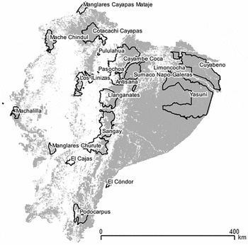
Ecuador is a megadiverse biodiversity hotspot (Myers Reference Myers1988; Bass et al. Reference Bass, Finer, Jenkins, Kreft, Cisneros-Heredia, McCracken, Pitman, English, Swing, Villa and Di Fiore2010) that faces many challenges from factors such as climate change, oil drilling, agricultural expansion and land degradation (Mittermeier et al. Reference Mittermeier, Myers, Thomsen, Da Fonseca and Olivieri1998; Brooks et al. Reference Brooks, Mittermeier, Mittermeier, Da Fonseca, Rylands, Konstant, Flick, Pilgrim, Oldfield and Magin2002; Rudel et al. Reference Rudel, Bates and Machinguiashi2002; Malcolm et al. Reference Malcolm, Liu, Neilson, Hansen and Hannah2006; Mena et al. Reference Mena, Barbieri, Walsh, Erlien, Holt and Bilsborrow2006). Ecuador's deforestation rate has been among the highest of the South American countries for over 20 years (Mosandl et al. Reference Mosandl, Günter, Stimm and Weber2008; Tapia-Armijos et al. Reference Tapia-Armijos, Homeier, Espinosa, Leuschner and de la Cruz2015). Ecuador's Ministerio del Ambiente (2012) estimates that c. 77,647 ha, representing c. 0.7% of Ecuador's forest cover in the year 2000, of ‘natural vegetation’ (the majority of which being natural forest) were lost per year between 2000 and 2008. On the other hand, Ecuador is still adding new protected areas to its portfolio (Fig. 1), with one of the latest additions being the c. 90,000-ha Colonso-Chalupas Biological Reserve (established in 2014). In order to optimize the effectiveness of protected areas in Ecuador, we need to know how effective different ‘types’ (e.g. in terms of size and strictness of protection) of areas have been at halting deforestation in recent decades (Messina et al. Reference Messina, Walsh, Mena and Delamater2006; Leisher et al. Reference Leisher, Touval, Hess, Boucher and Reymondin2013; Nolte et al. Reference Nolte, Agrawal, Silvius and Soares-Filho2013; Holland et al. Reference Holland, De Koning, Morales, Naughton-Treves, Robinson and Suárez2014), for which I compared deforestation rates inside various types of protected areas with each other and with deforestation rates outside these parks and reserves.
Map of Ecuador, with natural forest depicted in grey as estimated from remote sensing data of 2008 (Ministerio del Ambiente 2012). Superimposed boundaries are of all 19 (partially) terrestrial protected areas used in this study.

METHODS
I used data from a nationwide assessment of land cover change for 2000 to 2008 (Ministerio del Ambiente 2012), with a resolution of c. 30 m. The Ministerio del Ambiente used a combination of Landsat (2000 and 2008) and Advanced Spaceborne Thermal Emission and Reflection Radiometer (ASTER) (2008) images to create preliminary maps of forest cover, after which missing data (e.g. areas with high levels of cloud cover) were filled in with Landsat Enhanced Thematic Mapper Plus (Landsat EMT+) imagery (see Peralvo & Delgado Reference Peralvo and Delgado2010). Arguably, this gives a more detailed regional overview of forest cover for Ecuador than the products generated by Hansen et al. (Reference Hansen, Potapov, Moore, Hancher, Turubanova, Tyukavina, Thau, Stehman, Goetz, Loveland, Kommareddy, Egorov, Chini, Justice and Townshend2013), which serve more global efforts to estimate deforestation. The boundaries of the protected areas were available as shapefiles from Ecuador's National Protected Area System (SNAP; http://areasprotegidas.ambiente.gob.ec/), as were data on size, type of protection and year of establishment of each protected area.
In order to calculate and compare deforestation across sites, I created 20,000 randomly located plots (of c. 7 ha each) in QGIS (QGIS Development Team 2015). Instead of considering each pixel of 30 × 30 m as a unique plot, I chose plots that consisted of several pixels (c. 80), as this would approach the resolution used in other studies (e.g. Andam et al. (Reference Andam, Ferraro, Pfaff, Sanchez-Azofeifa and Robalino2008) used plots of 3 ha and Joppa et al. (Reference Joppa, Loarie and Pimm2008) used pixels of 1 km in resolution in order to calculate deforestation) and because averaging forest change over c. 80 pixels minimized the potential impact of misclassification of one single pixel. I filtered all plots in order to retain only those in which each pixel was classified as natural forest in the year 2000 by Ministerio del Ambiente (2012). Of the remaining 4879 plots, 1254 plots were located inside terrestrial protected areas that were established before the year 2000 and 3540 plots were located outside these protected areas. Another 85 plots were located outside protected areas established before 2000, but overlapped with areas that would become protected areas between 2000 and 2014, and these were excluded from further analyses.
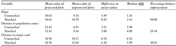
I calculated the mean slope of incline inside each remaining plot (a proxy for agricultural productivity and suitability; Farrow et al. Reference Farrow, Larrea, Hyman and Lema2005; Andam et al. Reference Andam, Ferraro, Pfaff, Sanchez-Azofeifa and Robalino2008), as well as distances from the centre of a plot to the nearest major road (already established in 2000) and population centre (which included any settlement with a permanent legal status, which usually implied a settlement of at least 10 households; Instituto Nacional de Estadística y Censos, personal communication 2016). For these analyses, I used freely available spatial data from the Instituto Geográfico Militar del Ecuador (2013). As these factors directly influence the level of human pressure in any given area (Andam et al. Reference Andam, Ferraro, Pfaff, Sanchez-Azofeifa and Robalino2008), I intended to minimize differences in the mean values for these three metrics by matching. I focused on these three factors because they are commonly used in matching exercises, they can be considered proxies for other important factors (such as suitability for agriculture) and they are available from reliable and accurate sources of spatial data. I used the MatchIt package (Ho et al. Reference Ho, Imai, King and Stuart2011) in R (R Core Team 2014) in order to calculate the Mahalanobis distance metric with replacement, two nearest neighbours and a calliper of 0.25 SD. As a result, I obtained 2508 ‘outside’ plots that matched 1254 ‘inside’ plots to a reasonable extent (matching led to a balance improvement of between 30% and 84%; Table 1).
Covariate balance before and after site matching on slope, distance to population centre and distance to major road of 7-ha plots inside and outside protected areas. eQQ = empirical quantile–quantile.

I calculated deforestation as the percentage of 30 × 30 m pixels in the plot that were classified as having been converted to non-forest land between 2000 and 2008. I also calculated the annual rate of deforestation within the protected areas by estimating the percentage of forest cover lost between 2000 and 2008, multiplying this figure by the total land area of the protected areas in this study (c. 4,000,000 ha) and dividing this by the time span of the study (8 years).
Subsequently, I compared the percentages of deforestation in all protected and all unprotected land on a national level, after which I calculated and compared deforestation in the c. 7-ha plots that were randomly located inside and outside protected areas. Finally, I compared deforestation in these random plots after matching them in order to minimize differences in the distance to the nearest road, distance to a population centre and slope of the terrain. For all of these analyses, I excluded protected areas that were marine, consisted of islands or were completely without forest cover.
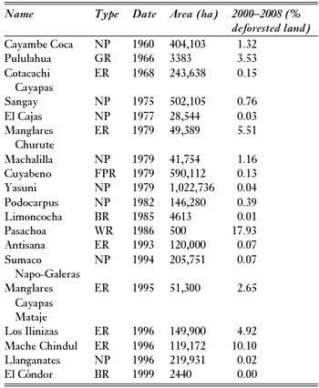
I used a generalized linear model (GLM) with interaction terms in order to assess the relationships between the size (ha), extent of forest (ha), age of the protected area (year established) and type of protected area, and the rate of deforestation in both 2000–2008 and 2000–2014. However, as I found a strong collinearity between forested area and the overall size of a protected area (linear regression, adjusted R 2 = 0.957, F = 417.7, p < 0.001), I dropped extent of forest (ha) in subsequent tests, testing only for the effects of size on deforestation. The ‘type’ of protected area refers to the different levels of protection provided within Ecuador's national system of public protected areas. Ranked from the most to the least strict level of protection were (amongst the remaining 19 protected areas in this analysis; Table 2) eight national parks (NPs), six ecological reserves (ERs), two biological reserves, one geobotanical reserve, one fauna production reserve and one wildlife refuge. I gave each of these categories an inverse rank (thus NP = 6, ER = 5, etc.) in order to test for correlations. More information regarding the categorization of protected areas in Ecuador can be found in Zárate (Reference Zárate2013).
Deforestation as a percentage of land area inside all protected areas of continental Ecuador that were established before 2000 (excluding those that had no forest cover). NP = national park; ER = ecological reserve; BR = biological reserve; GR = geobotanical reserve; FPR = fauna production reserve; WR = wildlife refuge (Zárate Reference Zárate2013).

In order to estimate how much forest would be lost if the protected areas had a deforestation rate similar to areas outside protected areas, I multiplied the difference in the percentage of forest loss inside and outside protected areas with the total land area of the protected areas used in this study (c. 4,000,000 ha) and divided the obtained number by 8 (the number of years of study).
RESULTS
I estimate that in all of Ecuador, between 2000 and 2008, c. 869,328 ha of natural forest were converted to non-forest land, representing over 6% of all land classified as ‘natural forest’ in 2000, while c. 247,342 ha of land were converted from non-forest land to natural forest. Regardless of whether this ‘new’ natural forest is even equal in habitat quality and composition to the natural forest that was lost, this still implies a net loss of c. 621,986 ha of natural forest in c. 8 years, or a rate of 77,748 ha per year. Inside protected areas, c. 79,600 ha were deforested in 8 years, equating to nearly 9950 ha per year. Note that these averages are taken over many years and that the actual deforestation rate might be higher or lower in any given year.
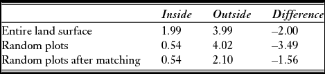
Protected areas experienced less deforestation than unprotected areas (Tables 2 and 3). The different approaches used to compare deforestation rates inside and outside protected areas provided different estimates of deforestation avoidance through protection (Table 3), but deforestation rates were consistently lower in protected areas than in unprotected areas. In fact, if the rates of deforestation inside and outside protected areas would have been similar, there would have been an additional loss of nearly 2% (c. 10,000 ha per year) of naturally forested land cover inside the protected areas (Table 3). The matching approach to calculating the difference in deforestation rates between protected and unprotected areas – a method that aims at measuring the effect of protection itself – generates an estimate of 1.56% less deforestation in protected areas, or a total of 7800 ha per year.
Deforestation inside versus outside protected areas in Ecuador between 2000 and 2008 as a percentage of land area based on Ministerio del Ambiente (2012). Protected plots: n = 1254; unprotected plots after matching: n = 2508; unprotected plots before matching: n = 3540.

Pasachoa Wildlife Refuge, the only wildlife refuge in this analysis, was an outlier with respect to deforestation rate, protected area size and type of protected area (Table 2). A GLM did not find significant positive effects of size, age or type of protected area on the deforestation rate inside the protected areas (all p > 0.01). There was a tendency for size of a protected area to affect deforestation rate (p = 0.044 for models using deforestation rates from Ministerio del Ambiente (2012)), but this was mainly driven by the low rate of deforestation in Yasuni National Park, which is by far the largest protected area in the sample (Table 2). An additional GLM in which Yasuni National Park was excluded yielded no significant effect of the size of a protected area (p > 0.05).
DISCUSSION
Governmentally controlled parks seem effective in at least one aspect of conservation: diminishing deforestation. However, the results of this study do not necessarily imply that these protected areas are maximally effective or that there is no room for improvement. Although deforestation is lower in protected areas than in unprotected areas, some protected areas do much better at avoiding deforestation than others (Table 2), and not one protected area experienced zero deforestation.
There are many factors that may drive differences in deforestation between areas, such as rates of local human population growth, the presence of particular hardwood species, the development of specific types of agriculture (e.g. shrimp farms and African palm Elaeis guineensis plantations), the distance to unofficial roads and trails, the distance to rivers or the suitability of land for agricultural purposes in general (Rudel Reference Rudel2000; Andam et al. Reference Andam, Ferraro, Pfaff, Sanchez-Azofeifa and Robalino2008; Barber et al. Reference Barber, Cochrane, Souza and Laurance2014). I used site matching in order to reduce differences between plots inside and outside protected areas with regards to three factors driving deforestation in Ecuador (Curatola et al. Reference Curatola, Obermeier, Gerique, López, Sandoval, Lehnert, Thies and Bendix2015). The results support the findings of Andam et al. (Reference Andam, Ferraro, Pfaff, Sanchez-Azofeifa and Robalino2008) that matching provides a more conservative estimate than an approach in which we simply compare deforestation inside versus outside protected areas.
Despite the reduction of differences between plots due to matching, plots inside protected areas remained further from major roads and population centres and were located on terrain with steeper slopes than plots outside protected areas. These differences might have led to overestimation of deforestation avoidance in protected areas that was due to protection per se. The difference in distance to major roads remained especially high (Table 1), and it is road access that likely determines deforestation rates in Ecuador (Curatola et al. Reference Curatola, Obermeier, Gerique, López, Sandoval, Lehnert, Thies and Bendix2015). The extent of this overestimation is difficult to define, but the difference in distance to roads between my protected and unprotected (control) plots is larger than the difference noted by Andam et al. (Reference Andam, Ferraro, Pfaff, Sanchez-Azofeifa and Robalino2008) in their ‘conventional comparison’. The amount of deforestation prevented due to protection (that I previously estimated to be c. 7800 ha per year) could be as low as 2600 ha per year if it was overestimated to a similar degree (a factor of three or more), as found by Andam et al. (Reference Andam, Ferraro, Pfaff, Sanchez-Azofeifa and Robalino2008). This would suggest that prevented deforestation through protection exists, but is rather minimal. It is worth highlighting that the distance to major roads was considerably higher in both my protected and control plots (18.94 and 12.84, respectively, after matching) than the distance of 5 km in which 95% of deforestation occurs in the Brazilian Amazon (Barber et al. Reference Barber, Cochrane, Souza and Laurance2014). It would be worthwhile to conduct studies on the effectiveness of parts of protected areas located fewer than 5 km from a road, as the deforestation rates in such plots might be much higher than the rates I found in this study.
I did not find effects of level of protection, age of the protected area, size of the protected area or size of the forested area inside protected areas on the percentage of deforestation. In contrast, previous studies suggest that at least some of these factors may influence deforestation rates. For example, Ferraro et al. (Reference Ferraro, Hanauer, Miteva, Canavire-Bacarreza, Pattanayak and Sims2013) showed that stricter protection could aid reduction of deforestation rates in Indonesia, Thailand and Costa Rica. Leisher et al. (Reference Leisher, Touval, Hess, Boucher and Reymondin2013) found that the size of a protected area has a significant effect on forest degradation (a distinct but related result of anthropogenic pressures). The differences between their results and mine could be due to a variety of factors, such as the use of data from different regions (e.g. all of South America instead of Ecuador only) or the adoption of a different approach to control for location bias (e.g. using buffers instead of matching, or matching with different parameters; Joppa and Pfaff Reference Joppa and Pfaff2010). In addition, the lag time between the establishment of a protected area and management actions taking effect might have already passed for most of the analysed protected areas, which would explain why there was no effect of the age of protected areas.
There were nevertheless notable differences between the rates of deforestation in at least some of the protected areas. For example, Yasuni National Park, the largest and most remote of the protected areas, had one of the lowest rates of deforestation, whereas Mache Chindul Ecological Reserve, a much smaller reserve close to the densely populated coast of Esmeraldas, had one of the highest rates of deforestation (Table 2). Pressure for agricultural land is high in Mache Chindul Ecological Reserve due to the presence of over 6000 inhabitants inside the reserve. Yasuni National Park, which is widely recognized for its high levels of biodiversity and endemism, seems to have been less affected at first, mainly because of its distance from major population centres and road infrastructure. This is rapidly changing, however, and threats from oil drilling and associated roads are predicted to lead to higher rates of deforestation and forest degradation in the future (Bass et al. Reference Bass, Finer, Jenkins, Kreft, Cisneros-Heredia, McCracken, Pitman, English, Swing, Villa and Di Fiore2010), especially since road access to Yasuni is now in development (Finer et al. Reference Finer, Pappalardo, Ferrarese and Marchi2014, Reference Finer, Babbitt, Novoa, Ferrarese, Pappalardo, De Marchi, Saucedo and Kumar2015). Moreover, although deforestation could have been relatively low between 2000 and 2008/2014, forest degradation, loss of species, pollution and other forms of human impact were likely already commonplace (Bass et al. Reference Bass, Finer, Jenkins, Kreft, Cisneros-Heredia, McCracken, Pitman, English, Swing, Villa and Di Fiore2010).
Although I limited this study to an analysis of deforestation, it is important to recognize the role of protected areas in reducing other anthropogenic changes (Nolte et al. Reference Nolte, Agrawal, Silvius and Soares-Filho2013). For example, Tapia-Armijos et al. (Reference Tapia-Armijos, Homeier, Espinosa, Leuschner and de la Cruz2015) clearly outline that fragmentation and isolation of forest patches is increasing in Ecuador, with detrimental effects that add to those that stem from deforestation per se. Moreover, it is important to recognize that even when deforestation rates appear to be lower in protected areas than in unprotected areas, and even though rates of deforestation seem to be decreasing in Ecuador (between 2000 and 2008, and this is projected to decrease even further between 2008 and 2028; Sierra Reference Sierra2013), levels of forest degradation (e.g. through selective logging) might still be high, and could well increase in the near future (Lewis et al. Reference Lewis, Edwards and Galbraith2015). In fact, deforestation inside protected areas might be lower than in areas that are unprotected, but forest degradation could well be higher (Htun et al. Reference Htun, Mizoue, Kajisa and Yoshida2009). Solely focusing on measures of deforestation and ignoring forest degradation may lead to overestimation of the conservation effectiveness of protected areas (Htun et al. Reference Htun, Mizoue, Kajisa and Yoshida2009). At first glance, deforestation might seem more severe than forest degradation, but the latter affects most of the world's forests and can be disastrous as it also leads to the loss of ecosystem services, changed habitat characteristics for a range of species, lowered species richness and diversity and loss of livelihoods for local communities (Lamb et al. Reference Lamb, Erskine and Parrotta2005).
Deforestation is a complex issue with no clear solutions and is best addressed in an interdisciplinary fashion (Laurance Reference Laurance1999), especially in Ecuador (Fiallo & Jacobson Reference Fiallo and Jacobson1995; Mena et al. Reference Mena, Barbieri, Walsh, Erlien, Holt and Bilsborrow2006; Messina et al. Reference Messina, Walsh, Mena and Delamater2006; Holland et al. Reference Holland, De Koning, Morales, Naughton-Treves, Robinson and Suárez2014). For example, I did not account for the impacts of governmental protection on local livelihoods and economies, which should be taken into account when drafting strategies for the reduction of deforestation and conservation. I also ignored the role that these local communities themselves can play in the reduction of deforestation and degradation, but areas with both governmental and communal forms of land tenure may be especially effective for the reduction of both deforestation and degradation in Ecuador (Holland et al. Reference Holland, De Koning, Morales, Naughton-Treves, Robinson and Suárez2014).
This study is not a substitute for a thorough analysis of the effectiveness of local and regional management, such as a park-by-park comparison of conservation results. Unfortunately, there is little current literature available on the effectiveness of protected area management on a local scale for Ecuador. Only such on-the-ground studies can give us the insights to improve on ineffective management, to adopt and spread the use of effective management policies and actions and to adapt management plans for changing pressures or environmental parameters. For example, regional and temporal variation in the drivers of deforestation will need to be studied in detail if we want to predict the rates of deforestation to be expected in the coming decades (Rudel et al. Reference Rudel, Defries, Asner and Laurance2009). The participation of local communities needs to be integrated at a local level as well, which is a requirement for effective protected area management (Wells & McShane Reference Wells and McShane2004).
The consequences of deforestation in Ecuador reach across political boundaries, because deforestation leads to increased CO2 emission and associated climate change, for example (Laurance Reference Laurance1999; Lawrence & Vandecar Reference Lawrence and Vandecar2015). Moreover, Ecuador is extremely biodiverse (e.g. Bass et al. Reference Bass, Finer, Jenkins, Kreft, Cisneros-Heredia, McCracken, Pitman, English, Swing, Villa and Di Fiore2010), has a very great number of endemic species and contains a wealth of pharmaceutical and commercial potential within its biota (e.g. Russell et al. Reference Russell, Huang, Anand, Kucera, Sandoval, Dantzler, Hickman, Jee, Kimovec and Koppstein2011). An effective conservation strategy for Ecuador's forests (e.g. one that considers complementarity in land protection; Naughton-Treves et al. Reference Naughton-Treves, Holland and Brandon2005) as well as a prompt reduction of the currently high deforestation rate would thus be vital contributions to the well-being of all of humankind.
ACKNOWLEDGEMENTS
I thank Ashley Ozelski (CUNY), Manuel Peralvo (CONDESAN) and two anonymous reviewers for their many helpful suggestions that greatly enhanced the quality of this paper.