INTRODUCTION
Coastal waters worldwide are subject to escalating pressures, with a dramatic increase in anthropogenic stressors on estuaries and shallow seas over the last 150–300 years (for example Lotze et al. Reference Lotze, Lenihan, Bourque, Bradbury, Cooke, Kay, Kidwell, Kirby, Peterson and Jackson2006). Impacts to neritic ecosystems are numerous and encompass a wide environmental scope at all levels of ecological organization, ranging from habitat losses to collapsed fish stocks (Lotze et al. Reference Lotze, Lenihan, Bourque, Bradbury, Cooke, Kay, Kidwell, Kirby, Peterson and Jackson2006; Österblom et al. Reference Österblom, Hansson, Larsson, Hjerne, Wulff, Elmgren and Folke2007).
Increases in the geographic extent, frequency, duration and severity of algal blooms are symptomatic of ecosystem stress in many coastal seas (Hallegraeff Reference Hallegraeff1993; Howarth & Marino Reference Howarth and Marino2006). The occurrence of blooms is commonly attributed to excess nutrients (Paerl Reference Paerl1997; Smith et al. Reference Smith, Runcie and Smith2005), because anthropogenic nutrient loads, particularly nitrogen and phosphorus, are typically linked to elevated algal growth in receiving waters (Howarth & Marino Reference Howarth and Marino2006; Paerl et al. Reference Paerl, Valdes, Peierls, Adolf and Harding2006; Smith Reference Smith2006); effects of cultural eutrophication can, however, propagate beyond primary producers and result in changes at higher trophic levels (Nixon Reference Nixon1995; Cloern Reference Cloern2001; Smith et al. Reference Smith, Joye and Howarth2006). In addition to the prominent role of nutrients, the intensity, timing and nature of herbivore grazing (Lotze & Worm Reference Lotze and Worm2000), changes in sea temperatures (Chavez et al. Reference Chavez, Strutton, Friederich, Feely, Feldman, Foley and McPhaden1999) and the physical advection and dispersal dynamics of the bloom site (Salomonsen et al. Reference Salomonsen, Flindt, Geertz-Hansen and Johansen1999) can also be contributing factors in bloom formation.
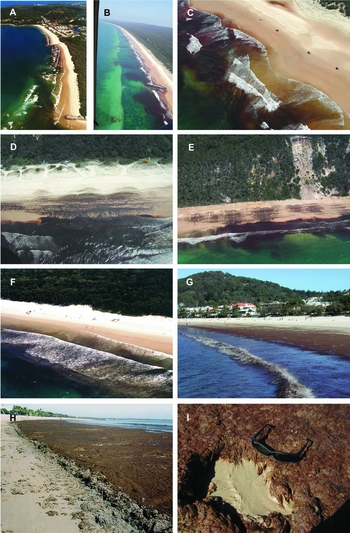
Drifting masses of bloom-forming macroalgae are not uncommon in coastal seas (Raffaelli et al. Reference Raffaelli, Raven and Poole1998). Drifting masses of algae typically accumulate in shallow, low-energy settings, such as bays, estuaries and harbours, or they are advected to the shore by tides and currents (Valiela et al. Reference Valiela, McClelland, Hauxwell, Behr, Hersh and Foreman1997; Berglund et al. Reference Berglund, Mattila, Ronnberg, Heikkila and Bonsdorff2003). Macroalgal blooms can profoundly modify habitats and produce diverse ecological impacts (Raffaelli et al. Reference Raffaelli, Raven and Poole1998). For example, increasing occurrences of filamentous algal mats have been linked to hypoxia in coastal waters (Bonsdorff Reference Bonsdorff1992). Hypoxia usually has large effects on the benthic fauna (Gray et al. Reference Gray, Wu and Or2002). Algal mats can have correspondingly large impacts on the geochemistry of benthic habitats and they change the structural and functional properties of the fauna in subtidal settings (Norkko et al. Reference Norkko, Bonsdorff and Norkko2000) and intertidal assemblages on sheltered (Bolam et al. Reference Bolam, Fernandes, Read and Raffaelli2000) and exposed shores (McGwynne et al. Reference McGwynne, McLachlan and Furstengerg1988). Surf zones of beaches are important fish habitats, especially as feeding sites and nursery grounds for many fisheries species of recreational and commercial importance (Romer Reference Romer1990). Because the amount of macrophyte debris in the surf has been shown to influence fish assemblages (Clark et al. Reference Clark, Bennett and Lamberth1996), macroalgal blooms that develop and persist in the surf zone of exposed sandy beaches (Fig. 1) may have detrimental consequence for fishes and reduce the value of this habitat as a feeding and nursery ground.
Examples of blooms of the brown macroalga Hincksia sordida in nearshore waters of Southern Queensland, Australia. (a) Nosa (26.38°S, 153.09°E) October 2003; (b, c, d) Fraser Island (25.55°S, 153.12°E) October 2005; (e) Rainbow Beach (26.93°S, 153.11°E) October 2005; (f, g, h, i) Noosa (26.38°S, 153.09°E) manifested as dense accumulations of algal biomass in the surf zone (f January 2003, g October 2003) and deposits on the beaches (h October 2004, i October 2003).

Dense and persistent macroalgal blooms can cause considerable economic damage when they diminish the value of beaches and nearshore waters for human recreation and tourism (Hoagland et al. Reference Hoagland, Anderson, Kaoru and White2002). This is the case for blooms of the brown algae Hincksia sordida (Harvey) Silva (Heterokontophyta, Phaeophyceae) on the subtropical east Australian coast (Phillips Reference Phillips2006). Hincksia sordida is endemic to Australia with a wide geographic range across the continent. In its attached form, it grows as entangled masses, usually 5–20 cm high, being epiphytic on larger algae or seagrass, or attached to rocks in sheltered waters (Phillips Reference Phillips2006). The species has formed blooms in Port Philip Bay, where outbreaks were linked to nutrient loading from wastewater treatment plants (Campbell Reference Campbell1999, Reference Campbell2001). At Noosa, in south-east Queensland, unattached thalli of the algae have formed large masses in the surf zone of popular tourist beaches and algal mats have blanketed the shore when the tide receded (Fig. 1). It is currently unknown whether these accumulations were linked to anthropogenic nutrient loading or other stressors. Irrespective of the cause, the blooms occurred during the austral spring and summer, which is the peak tourist season, and dramatically reduced the aesthetic appeal of the beach, with considerable repercussions for the local economy (Phillips Reference Phillips2006).
Local ecological knowledge (LEK) is the information a group of people know about local ecosystems; in contrast to traditional ecological knowledge, it does not require a continuous historical and cultural connection with the ecosystem or land (Olsson & Folke Reference Olsson and Folke2001). Local knowledge of the history and ecology of a site or natural resource can be a valuable tool in environmental management (Robertson et al. Reference Robertson, Nichols, Horwitz, Bradby and MacKintosh2000; Evans & Birchenough Reference Evans and Birchenough2001; Robertson & McGee Reference Robertson and McGee2003; Begossi Reference Begossi2008).
Environmental planning, assessment and management can benefit greatly from the application of LEK. Benefits of using LEK as an instrument in natural resource management span a wide range of social, practical and economic aspects, including among other things: (1) enhancing public participation and early conflict resolution, (2) providing opportunities for local communities to articulate values and concerns, (3) increasing the understanding of the social context for managers, (4) identifying environmental issues and possible solutions not known through other formal processes and (5) creating novel hypotheses amenable to formal scientific testing and research. However, using LEK with non-random sampling bias, uneven recollection of events over time or strategic responses could confound the analysis (Christie & White Reference Christie and White1997; Agrawal & Gibson Reference Agrawal and Gibson1999; Robertson et al. Reference Robertson, Nichols, Horwitz, Bradby and MacKintosh2000; Evans & Birchenough Reference Evans and Birchenough2001; Kapoor Reference Kapoor2001; Myatt-Bell et al. Reference Myatt-Bell, Scrimshaw, Lester and Potts2002; Robertson & McGee Reference Robertson and McGee2003; Head Reference Head2004; Begossi Reference Begossi2008). Perhaps most fundamentally, community-based environmental management is often advocated because it is thought to fulfil three essential criteria for good governance, namely sensitivity towards indigenous (or local) knowledge, responsiveness to context and local priorities and imperatives, and efficiency of implementation (Kellert et al. Reference Kellert, Mehta, Ebbin and Lichtenfeld2000; Gray et al. Reference Gray, Enzer, Kusel, Gray, Enzer and Kusel2001).
LEK and oral history become important instruments in situations where no or very fragmentary and limited recording of environmental conditions and events has occurred (Robertson et al. Reference Robertson, Nichols, Horwitz, Bradby and MacKintosh2000; Robertson & McGee Reference Robertson and McGee2003; Tibby et al. Reference Tibby, Lane and Gell2007). This is the case for macroalgal blooms of Hincksia sordida in southern Queensland (Lovelock et al. Reference Lovelock, Clegg, Hurrey, Udy and Moore2008). In this region, macroalgal blooms have not been monitored or documented, and the information on blooms exists almost exclusively in the form of observations and ‘mental records’ by people familiar with local coastal waters. Thus, harnessing LEK is the most practical method of obtaining information on this particular environmental problem.
Management and mitigation of the blooms in southern Queensland has become a critical, and at times a highly political, issue (Phillips Reference Phillips2006; Lovelock et al. Reference Lovelock, Clegg, Hurrey, Udy and Moore2008). The development of management and mitigation interventions is, however, impeded by a lack of knowledge about the phenology of the blooms and their likely causes. What triggers the blooms at this locality has not been established with confidence, and key attributes of the bloom events (such as time of onset, geographic extent or historical records) remain unknown. Thus, the local government authority charged with managing and mitigating the blooms requires defensible answers to relatively simple questions such as: (1) what is the geographic distribution of the blooms (namely is it a local or a regional problem)? (2) Have blooms become more severe and do they last longer in recent years? (3) Are there climatic and oceanographic factors which coincide with bloom formation? This study was designed to answer these questions, based on a broad and comprehensive collation of LEK and oral histories.
METHODS
Study area
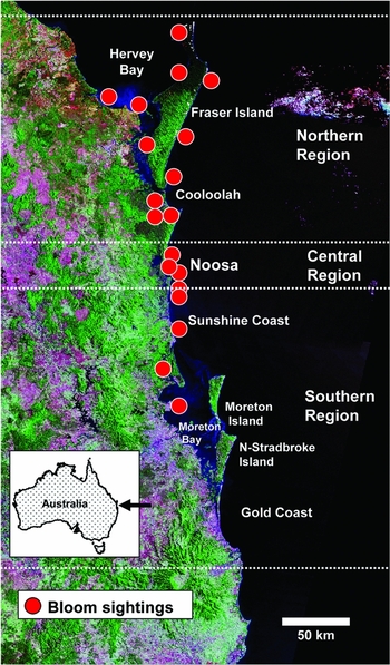
This study was conducted along c. 450 km of coastline in southern Queensland (Australia) from Coolangatta in the south (28.17°S, 153.55°E) to Fraser Island in the north (24.70°S, 153.44°E). The open coastline of the region is dominated by sandy beaches, punctuated by isolated, short, rocky headlands. Three large barrier islands (North Stradbroke, Moreton and Fraser Island) are located offshore; Fraser is the world's largest sand island. North Stradbroke and Moreton Islands form the eastern boundary of Moreton Bay, the largest sheltered coastal water body along this coast (Fig. 2); Fraser Island encloses sheltered Hervey Bay in the North (Fig. 2). The coastal plain is relatively narrow, generally <100 km, and incised by numerous estuaries.
Geographic distribution of bloom sightings of brown algae that were likely to have been Hincksia sordida in southern Queensland, Australia.

Geographic coverage extended over the whole area defined above, but a particular focus of our study was on the embayment, beaches and coastal waters adjacent to the town of Noosa (26.38°S, 153.09°E) because, in recent years, algal blooms have been most severe at this locality (Phillips Reference Phillips2006), and it is amongst Australia's top tourism destinations. One of its main attractions are the beaches of Laguna Bay, which have been heavily affected by algal blooms in recent years, causing considerable economic damage.
Survey of bloom attributes
At Noosa, the amount of stranded algae and the duration of the blooms increased progressively from 2001, culminating in the very severe bloom event of 2004. This outbreak, which virtually closed the beaches for several weeks during the peak tourist season, raised significant concerns within the local community in connection with substantial economic losses caused by the algae. It therefore became necessary to define key attributes of the blooms and identify putative factors that may promote bloom development.
Algal blooms reported in this survey were restricted to sightings which were likely to have been that of the brown alga Hincksia sordida based on colour and texture of the algae, excluding reports of green algae (for example Ulva), Trichodesmium, kelp and other algae. For most observations, no expert species identification was available; thus, brown algal blooms were putatively taken to be Hincksia sordida rather than being confirmed cases of this species at a certain locality and time.
Because there was no formal, consistent and continuous recording of bloom events, this paucity of recorded data meant that oral reports by long-term residents were the only available source of information for the environmental history of the site and bloom events (see also Robertson et al. Reference Robertson, Nichols, Horwitz, Bradby and MacKintosh2000; Robertson & McGee Reference Robertson and McGee2003). Structured interviews (Fogerty Reference Fogerty, Egan and Howell2001) were used to collect information about algal outbreaks and to obtain an oral history of the blooms. Interviews were based on a set of pre-defined questions (for example year and month of bloom events), complemented by open-ended questions about factors promoting bloom formation and dispersal (Appendix 1, see supplementary material at Journals.cambridge.org/ENC). Thus, our approach was a structured conversation with participants who, through personal experience, possessed information about the blooms, and analysis of their responses provided both an oral environmental history (for example Robertson et al. Reference Robertson, Nichols, Horwitz, Bradby and MacKintosh2000; Robertson & McGee Reference Robertson and McGee2003) as well as identifying possible causes of blooms.
We purposefully included a broad spectrum of respondents engaged in coastal activities, the prime selection criterion being that respondents had above-average levels of personal, hands-on experience and knowledge about the local marine environment. Survey respondents included local council officers (23%), national park rangers (18%), members of volunteer organizations (coastguard, environmental and ratepayers; 10%), amateur fishers (3%) and people who ran aquatic (35%) or other businesses (11%); aquatic businesses included commercial fishers, water-sports instructors, equipment hire firms and water-based tour operators. Most interviews in the Noosa areas were face-to-face, whilst those from outside the Noosa area were done via telephone. A total of 61 people were interviewed during February 2005. We interviewed 34 respondents from the focal area of Noosa, with an additional 13 people from areas to the north and 14 people from areas to the south of Noosa.
More than 80% of the respondents had >10 years experience with local conditions. Over half of the respondents (54%) had >20 years of experience in the area, 30% of people interviewed could provide observations that spanned ≥30 years in the local area and 8% of respondents stated 45 years experience in the area. The longest ‘memory record’ in our survey was 55 years, with a further two respondents having at least 50 years of personal, first-hand observations. The mean number of years of experience of all respondents from all areas was 22 years. The 33 respondents from the Noosa region had an average of 24 years experience, whilst the average was 19 years for the 27 respondents from outside the Noosa area.
One-third of all respondents visited ocean beaches daily, with a further 51% visiting a beach at least once per week. The visit pattern for inshore waters was similar, with respondents stating that they had made visits to, or observations of, the ocean on a daily basis, with an additional 52% being able to provide observations of nearshore waters at a frequency of at least once per week. Visit frequency for beach and ocean varied slightly owing to some respondents being in boats that were operating too far from the beach to offer an informed comment on beach conditions.
Respondents were also asked to provide a qualitative ranking of the severity of the blooms they had seen. ‘Severity’ was mainly related to the volume of algae and the area of beach that the algal mat covered. Thus, the severity rating scale ranged from 1 (mild with sparse algae in the water and/or covering a small area of the beach) to 5 (very dense algae that occupied extensive sections of the beach and/or the surf zone).
To determine the seasonal pattern of bloom occurrence, we asked participants to recall the month and year when they saw a bloom appear, and how long it lasted. Participants in the interviews were also asked to list any factors or conditions that they observed to coincide with the arrival of the blooms. In addition to requesting information on factual observations by survey participants (such as arrival and duration of blooms or weather conditions during bloom development), an open question was included that was designed to gauge the respondents’ opinions concerning the underlying causes of blooms.
Differences in the number of bloom sightings between regions were analysed with an analysis of co-variance model (ANCOVA; Zar Reference Zar1996) correcting for possible observer bias in terms of three parameters: (1) years of experience, (2) number of beach visits per year, and (3) total observation days. Total variation in bloom properties (arrival time, duration and severity) was partitioned with a general linear model (Underwood Reference Underwood1997) that included as a spatial factor ‘Region’ (north, central or south) and ‘Year’ as the temporal factor (pre-2000, 2000, 2001, 2002, 2003 or 2004). Wind fields were numerically characterized by grouping records into the 16 main directions of the compass; these fields were then compared between years using analysis of similarities (ANOSIM; Clark Reference Clarke1993) in the multivariate domain to test whether wind regimes differed significantly between years with and without algal blooms.
RESULTS
Geographic distribution of bloom sightings
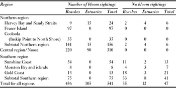
Five hundred and forty-one records of brown algal bloom sightings were obtained through the interviews, of which 436 (81%) were for beaches and nearshore marine waters and 105 (19%) for estuaries (Table 1). Estuarine sightings were restricted to only two systems, namely the Noosa Estuary (90 records) and estuarine waters bordering Hervey Bay and the Great Sandy Strait (15 records) (Table 1).
Geographic distribution of records of blooms and no blooms of the brown alga Hincksia sordida in each of three regions in southern Queensland, Australia (cf. Fig. 2).

The number of years for which respondents could provide observations on coastal waters was not related to the number of blooms they reported (rs = 0.07, p = 0.59, n = 61). After correction for experience and observation effort, significantly fewer blooms were reported from beaches and nearshore waters south of Noosa (Appendix 2, see supplementary material at Journals.cambridge.org/ENC). By contrast, the frequency of bloom records was similar for Noosa and areas further north (Appendix 2, see supplementary material at Journals.cambridge.org/ENC). The number of blooms reported was not correlated with how often observers visited beaches or nearshore marine waters (rs = 0.06, p = 0.63, n = 61).
Long-term trends in bloom sightings
Participents indicated Hincksia sordida blooms have occurred in southern Queensland for >40 years, with sightings dating back to 1965. Although medium-term ‘memory records’ of blooms on beaches and in nearshore marine waters were patchy for some regions, a more complete and contiguous time sequence appears from around 1980 onwards. This suggests that blooms occurred more regularly (for example every year or in most years) over the past 25 years. Bloom occurrences in estuaries were more limited, being essentially restricted to the last 12 years for the Hervey Bay system (1995 onwards), while the first reported sighting of Hincksia sordida from the Noosa Estuary was in 1990.
Seasonality and severity of blooms
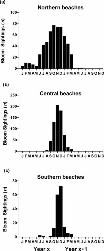
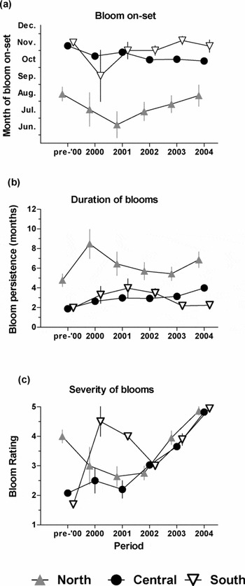
There was substantial spatial variation in the seasonal timing of bloom occurrence, with blooms occurring later in the year with increasing latitude. In regions north of Noosa, the blooms appeared in the early austral winter (June–July) and lasted until the end of the austral summer (February–March of the following year (Figs 3 and 4). At Noosa, the ‘bloom season’ appeared to be shorter, starting in September–October and lasting until December–January (Figs 3 and 4). Further south, blooms developed even later in the year (November) and usually dispersed 1–2 months later (Figs 3 and 4). The seasonal pattern for blooms reported from estuaries was broadly similar to beach blooms for the Noosa area, with most bloom records for estuaries spanning a period from September to January.
Seasonality of algal blooms in the three study regions. Because many blooms straddle calendar years, occurring often from spring to late summer, the temporal distribution is plotted from the first calendar year when a bloom developed (year x) to the following calendar year (year x + 1) when the bloom dispersed.

Temporal trends in (a) the time of bloom arrival on beaches and in nearshore marine waters, (b) the duration of blooms and (c) their severity (respondents rated severity qualitatively on a scale ranging from 1 = mild and sparse to 5 = sustained and dense). Error bars are one standard error of the mean.

Not only do the blooms arrive earlier on the beaches to the north of Noosa, but they also remain there longer. The average time for which blooms remained on the northern beaches was six months compared with three months for the Noosa blooms (Figs 3 and 4). The few blooms reported from the south were significantly shorter in duration than in both the other regions, lasting on average two months and one week (Figs 3 and 4).
There is no significant temporal trend over the years with respect to bloom duration in the North (Appendix 3, see supplementary material at Journals.cambridge.org/ENC). At Noosa however, the duration of blooms has become significantly longer over the years, particularly during 2004 when the bloom remained for four months compared with two to three months in previous years (Appendix 3, see supplementary material at Journals.cambridge.org/ENC). No clear temporal trend in bloom duration is evident for the few records from the south.
The severity of blooms differed substantially between the three regions, with the average bloom severity ranked higher in the northern sections (3.86) than Noosa (3.21) or the southern sections (2.94). Most respondents judged the blooms to have become more severe in recent years at Noosa (Appendix 3, see supplementary material at Journals.cambridge.org/ENC; Fig. 4).
Factors coinciding with bloom development and dispersal
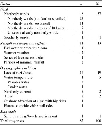
Participants showed remarkable internal consistency as to the factors and conditions that they had observed to coincide with the arrival of the blooms, and these could be grouped into a narrow band of conditions (Table 2): more than half (57%) of all respondents identified northerly winds as the key contributing factor for algal bloom development. A further 13% listed rainfall and temperature, with ‘warm weather’ (seven returns) being the most prevalent in this category. Small swells and surf waves were mentioned by 19% of respondents to coincide with the arrival of algal blooms (Table 2).
Factors put forward by respondents to coincide with the arrival of algal blooms and/or processes that may contribute to the formation of blooms.

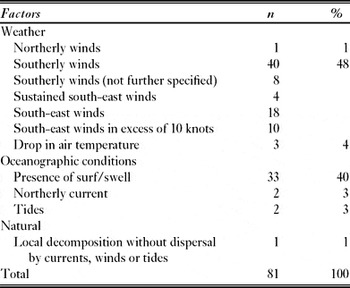
Of all the factors that were thought to contribute to the dispersal of algal blooms, almost half (48%) of responses cited winds from the south (Table 3). This is almost an exact juxtaposition to the 57% of responses that listed northerly winds when the blooms develop in the surf zone of the beaches. The presence of swell and surf was cited with almost equal frequency, with blooms perceived to disperse around the same time that swell and surf increased in height. There were only few responses that did not relate to southerly winds or swell/surf and these included northerly currents, tidal advection and decomposition of the algae (Table 3).
Factors put forward by respondents to coincide with the dispersal of algal blooms.

Putative causes of blooms
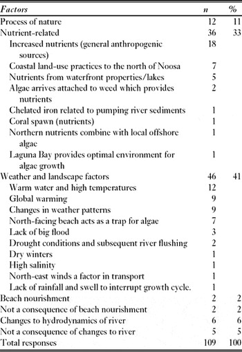
It must be stressed that ‘causes’ reported by participants in the interviews have not been critically examined, independently tested or reviewed; they essentially represent opinions only. Nevertheless, to the open question as to the underlying causes of blooms, participants offered a diverse range of opinions (Table 4). Responses fell into four broad categories. (1) Weather was cited most often as being related to bloom formation (46 responses), with participants suggesting that warmer air- and sea-temperatures were possible causes. (2) Nutrients were the second most frequently cited ‘cause’ of the blooms (36 responses), suggested sources of putatively elevated nutrients included unspecified anthropogenic sources, changed coastal land uses, canal estates and Trichodesmium (Table 4). (3) Natural causes were put forward 12 times without explicit links to human activities. (4) Man-made causes other than nutrients, such as beach nourishment, were thought to be linked to blooms or not (Table 4). A similar contrast of opinions existed with respect to changes in the flow regime of the lower estuary: six participants cited changes to the hydrodynamics of the estuary as a cause, while five participants stated that this was not linked to algae.
Factors cited by respondents as possible causes contributing to the formation of algal blooms.

DISCUSSION
Utility of local knowledge in the management of macroalgal blooms
Bottom-up approaches that embrace local communities, stakeholders and citizens as active participants in environmental management are often considered to be democratic and effective (Carr Reference Carr2002). Community-based environmental management and the use of LEK to address ecological change are frequently advocated on the grounds that they are more sensitive to local conditions, engage local citizens in decision-making, use and deploy environmental knowledge in the community and customize management to reflect the nuanced complexities of local circumstances (Kelly Reference Kelly1998; Robertson et al. Reference Robertson, Nichols, Horwitz, Bradby and MacKintosh2000; Kapoor Reference Kapoor2001; Robertson & McGee Reference Robertson and McGee2003).
In the case of the algal blooms investigated here, the structured interviews operated at the ‘grassroots level’ of community-based environmental management (for example Carr Reference Carr2002). By actively engaging local citizens, they provided information on certain key attributes of blooms (such as duration, severity, time of formation and dispersal and geographic extent) which could not have been obtained by other means; thus LEK was a valuable tool to address the issue of algal blooms. LEK also generated several hypotheses about the causes and sources of algae that had not been documented by other approaches, such as the hypothesized role of particular wind regimes in promoting bloom development (see later).
An important aspect of community-based environmental management is that local citizens feel more included in the planning process, which strengthens their ‘sense of ownership’ for a site and its ecosystems (Carr Reference Carr2002). By encouraging public participation, the community is also more likely to accept policy change in the future, and the process provides a medium to inform and educate the local community (Evans & Birchenough Reference Evans and Birchenough2001; Kapoor Reference Kapoor2001). We found that most of the participants in our interviews greatly valued the opportunity to ‘contribute’ to the management of algal blooms, and appreciated that their knowledge was recognized as a valuable tool to address the issue. While some participants whose business was tangibly affected by blooms (for example tourism operators) already had a high level of activism about the bloom issue, the interviews provided a structured means for them to become officially recognized as players in the process. Engagement was especially important for those participants who felt they had been disenfranchised and had little opportunity to contribute. Thus, harnessing LEK provided not only data on blooms, but was also an important process to strengthen public participation in the management of this environmental problem.
Despite documented successes of community-based environmental management, it can at times produce sub-optimal outcomes. Failures have been reported in terms of not meeting conservation or remediation objectives, or in terms of marginalizing science and disenfranchising disadvantaged actors (Kellert et al. Reference Kellert, Mehta, Ebbin and Lichtenfeld2000; Lane et al. Reference Lane, McDonald and Morrison2004; Lane & Corbett Reference Lane and Corbett2005; Lane & McDonald Reference Lane and McDonald2005). Similarly, privileging local knowledge can result in flawed decisions when the accuracy of the local knowledge is poor or unreliable (Tibby et al. Reference Tibby, Lane and Gell2007). We cannot exclude the possibility of sub-optimal data, particularly if participants do not recall past blooms accurately, but believe that here the information was generally reliable: the great majority of participants had long experience of the local environment and they had formed a close connection with the ocean, in either a professional or recreational capacity. In fact, 36% of participants visited the ocean daily, and a further 31% at least four days per week. The observed de-coupling between observation period and bloom numbers indicates that blooms are a relatively recent phenomenon; it could, however, equally occur owing to a decrease in the long-term memory of bloom events.
In local knowledge some subjects and events are more readily recollected than others, particularly major environmental disturbances such as floods (Lane Reference Lane1997; Robertson & McGee Reference Robertson and McGee2003). Since algal blooms are very prominent events and have tangible recreational and economic consequences for local residents, it is likely that interviews in this study captured a significant portion of actual bloom events over the last two to three decades.
We found no relationship between observation time and bloom frequency, suggesting that blooms were prominent features and lasted long enough to be seen by most participants in the interviews, irrespective of how often they visited the beach. Thus, few, if any, blooms are likely to have been missed by the people interviewed. Our oldest bloom record was from 1965. This does not necessarily represent the oldest record of actual blooms, because it is based on the history of personal experiences of the participants in our interviews. Thus, the possibility that blooms have occurred prior to 1965 cannot be excluded. Irrespective of such ‘historical limitations’, it appears that blooms are not a recent phenomenon of the last couple of years only, but are likely to have occurred in the coastal waters of Southern Queensland for at least several decades.
Cross-validation of local ecological knowledge
LEK can provide a wealth of data (Tibby et al. Reference Tibby, Lane and Gell2007; McFadden Reference McFadden2007), but these need to be triangulated with data from other sources (Robertson & McGee Reference Robertson and McGee2003; Lane & McDonald Reference Lane and McDonald2005; Finlayson & Brizga Reference Finlayson and Brizga1995). LEK can also unearth novel environmental information (Robertson et al. Reference Robertson, Nichols, Horwitz, Bradby and MacKintosh2000), but can also be misleading when erroneous ideas uncritically gain acceptance by being quoted frequently (Finlayson & Brizga Reference Finlayson and Brizga1995).
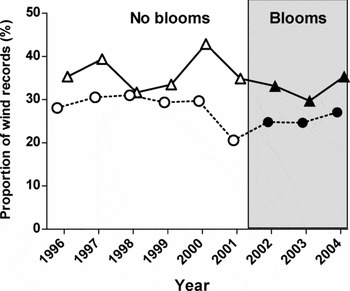
Here LEK suggested that particular wind regimes were linked with the development of algal blooms, a new hypothesis which we formally tested by comparing wind regimes (namely strength and direction) in relation to observed bloom events (see URL http://www.bom.gov.au for sources of wind data). The view that northerly to easterly winds preceded the arrival of blooms on the beaches of Laguna Bay (Table 2) was not supported: wind fields did not differ between bloom and non-bloom years. (Appendix 4, see supplementary material at Journals.cambridge.org/ENC). There was also no distinct and consistent increase in the percentage of northerly to easterly winds during bloom years (2001–2004) when compared to previous years when blooms were less prominent (Fig. 5).
Temporal trajectories of the proportion of north to easterly winds (0–90°) in non-bloom and bloom years (shaded) at two recording stations closest to Laguna Bay: Tewantin (triangles) and Double Island Point (circles).

However, the possibility that wind may play some role in forming and sustaining the blooms cannot be excluded. Our analysis was constrained to composite data (such as monthly wind fields), because no daily quantitative data on the exact arrival times of the blooms were available. It may be possible that certain combinations of wind direction and wind speed (for example sustained northerly winds blowing at >15 km hr−1 for > 2 days) are more accurate descriptors of any relationship between wind and bloom formation. Daily recording of blooms should be a core element of all future monitoring.
Nutrients were the second most frequently cited ‘cause’ of the blooms in our study, and they fuel algal blooms of many species in a variety of settings (Valiela et al. Reference Valiela, McClelland, Hauxwell, Behr, Hersh and Foreman1997; Cloern Reference Cloern2001; Howarth Reference Howarth2008; Schlacher et al. Reference Schlacher, Skillington, Connolly, Robinson and Gaston2008). Low levels of nitrogen can sustain high rates of growth in Hincksia sordida in laboratory experiments, and the alga is physiologically highly active in the surf zone where it can grow rapidly (Lovelock et al. Reference Lovelock, Clegg, Hurrey, Udy and Moore2008). However, nutrient levels in inshore waters of the Noosa area are low compared to other regions where macroalgal blooms occur, suggesting that nutrient pollution may not be the principal driver of blooms at this site (Lovelock et al. Reference Lovelock, Clegg, Hurrey, Udy and Moore2008).
Blooms of Hincksia sordida have also been recorded at the northern tip of Fraser Island (T.A. Schlacher, personal observation 2004), an area which is remote from likely sources of anthropogenic nutrient pollution and any estuarine influence. Discharges from estuaries to nearshore marine waters in the form of prominent turbidity plumes can be a significant source of nutrient inputs from the land to the ocean on this coast and elsewhere (Gaston et al. Reference Gaston, Schlacher and Connolly2006). Marine plankton and benthos in receiving waters incorporate nitrogen and carbon delivered by these plumes (Schlacher et al. Reference Schlacher, Skillington, Connolly, Robinson and Gaston2008; Schlacher & Connolly Reference Schlacher and Connolly2009; Connolly et al. Reference Connolly, Schlacher and Gaston2010), and this may be a putative mechanism to stimulate algal blooms. Plumes from the Noosa estuary are, however, generally small and ephemeral and we have not observed any obvious concurrence between estuarine discharge events and algal blooms (T.A. Schlacher, personal observation 2004), suggesting that outwelling of nutrients from the estuary may not be a primary factor in stimulating blooms at this location (but see Phillips Reference Phillips2006).
Twenty-nine respondents also offered opinions about the source of the algae. Eleven participants stated categorically that the algae do not originate from the Noosa Estuary, and 13 participants cited an offshore source of the algae, either from an unspecified offshore origin (n = 7) or from regions north of Noosa (n = 4). Four participants located the source of the algae in Laguna Bay. However, there is no unequivocal data on the source of the algae which give rise to the blooms at Noosa. Possible candidates for the algal ‘source’ habitat span a gradient from a putative estuarine origin (Phillips Reference Phillips2006), although blooms at Fraser Island are very remote from any estuary, to offshore deep water that may harbour the overwintering microscopic stages of the alga (Lovelock et al. Reference Lovelock, Clegg, Hurrey, Udy and Moore2008).
Scale and management considerations
Scale is an important issue in environmental assessment and management, the spatial ambit at which the issue is perceived and at which the response is instigated (Lane & McDonald Reference Lane and McDonald2005). Laguna Bay is not a closed system; it has a marine offshore margin whose boundary conditions are highly permeable for the exchange of inorganic (for example nutrients) and organic (for example algal spores and fragments) particles. Both the problem and the likely causes of the algal blooms are not necessarily local issues. Local communities and government entities may therefore not be well placed to identify the correct drivers or to suggest appropriate local solutions.
Over a wider geographic area, new insights may emerge from LEK. We identified that the Hincksia blooms affected much of the regional coastline and the timing of their development appears to follow a progression from north to south; these findings have wider management implications, which require a regional approach complemented by local actions where needed.
These local actions aim to mitigate the economic fall-out of blooms when masses of algae close beaches to tourists and harm the hospitality and associated industries. The local government authority removes deposits of algae from the beaches using heavy machinery (Phillips Reference Phillips2006). This provides for a temporary aesthetic improvement, but does not measurably reduce the amount of algae in the surf zone. Removal of algae from the surf zone with seine nets has also met with limited success (P. Milne, personal communication 2007), and can only target a small fraction of the total algal biomass. The alternative is to prevent the algae from reaching the surf zone and becoming stranded on the beach. A 100-m long and 2-m high fine mesh barrier anchored to the seabed offshore of the breaker zone at Noosa Beach is designed to arrest the onshore advection of algae; it is currently undergoing sea trials.
CONCLUSIONS
Algal blooms present a coastal management challenge that often enjoys a high public profile and which has the potential to cause serious ecological and socioeconomic impacts (Hoagland et al. Reference Hoagland, Anderson, Kaoru and White2002). In such situations, it is advantageous to address complex environmental problems through collaborative arrangements in which stakeholders, communities and scientists jointly develop management actions based on a synthesis of local and scientific knowledge (Busenberg Reference Busenberg1999; Tibby et al. Reference Tibby, Lane and Gell2007). Our study has shown that harnessing LEK can provide a wealth of information on the properties and dynamics of algal blooms and generate testable hypotheses about factors stimulating bloom development and decay. It has also emphasized that blooms are not a recent phenomenon and that scientific efforts to understand bloom formation must operate at both regional and local scales. A multi-scalar tactic will also be effective at addressing and managing bloom events where local mitigation actions are combined with regional efforts to target the drivers of blooms.
ACKNOWLEDGEMENTS
We thank Sunshine Coast Regional Council (formerly Noosa Shire Council) for supporting this study logistically and financially, especially Ben McMullen and Peter Milne. We are grateful for the ready and willing spirit of the interview participants for allowing us to harvest LEK and thank the Moreton Bay and Catchments Partnership which championed many aspects of the algal bloom investigations, particularly Eva Abal.