Introduction
In a socially stratified and diverse city, it is common to witness spatial clusters of people based on various factors, including ethnicity, social class, wealth, occupation and immigration status. People with these traits overlap and intermingle in complex ways within urban areas around the world. While such clustering presents various advantages, it can also contribute to physical segregation among groups of city inhabitants. Clustered or segregated groups can be discerned in some districts or neighbourhoods, while there may simultaneously exist other living quarters within a city where people with different variants are more mixed and interspersed.
Urban planning, to varying degrees and extents, was a relatively common practice in ancient cities (e.g., Smith Reference Smith2007). This involved pre-planned and centrally organised construction, which could encompass an entire city or specific areas within it. Planning must involve a decision-making authority operating at a supra-household level, such as neighbourhood, local community, district, city, state or a combination of these. A brand new planned city can be created in a previously uninhabited area, or a pre-existing settlement can be reconfigured through pre-determined planning. This type of project often results in distinct urban features, such as robust city walls, standardised housing blocks, grid-patterned streets and long, straight thoroughfares that sometimes radiated from central districts.
This article explores a possible correlation between centralised planning and economic homogenisation, particularly in ancient urban residential neighbourhoods.Footnote 1 It explores how pre-designed and constructed living quarters may have resulted in the concentration of residents with similar wealth levels. Several ancient sites are discussed to illustrate this correlation. In particular, excavated residential areas at the third millennium B.C. cities of Tell Asmar and Khafajah in central Mesopotamia serve as case studies for examining this correlation (Fig. 1). One of the areas at Khafajah stands out due to its centrally planned construction, dating to around 2400–2300 B.C. Furthermore, occupation layers before this construction event provide insight into the potential diachronic changes within this part of the settlement. By utilising the Lorenz curve and Gini coefficient, this research suggests that houses built as part of the preconceived project exhibit a slightly higher degree of economic similarity when compared to houses at other levels within these sites. The degree of wealth inequality between private dwellings is determined by factors such as house size and artefacts found within these houses. These findings support the notion that centralised planning in a residential area is associated with economic levelling and homogenisation among the inhabitants in that specific area.
Settlements in Mesopotamia from the mid-late third to early second millennium B.C., mentioned in this study (base map by NASA)

Ancient Urban Residential Clustering
Urban residential clustering or segregation took diverse forms in ancient societies. Segregation created cities with distinct neighbourhoods based on a set of socio-economic traits. For example, large, urbanised settlements in central Mexico, such as Teotihuacan and Tenochtitlán, are known to have some neighbourhoods organised along ethnic or occupational lines (see York et al. Reference York, Smith, Stanley, Stark, Novic, Harlan, Cowgill and Boone2011: 2409 for summary). Moreover, the correlation between spatial organisation and wealth disparity has long been debated in the context of Classic period Maya cities (ca. A.D. 250–900), such as Tikal, Caracol, Mayapan, Chunchucmil and Coba.Footnote 2 Some researchers argue that individuals from different economic strata did not live side-by-side within Maya cities, such as Tikal, Caracol and Coba (Chase and Chase Reference Chase and Chase2004; Dennehy et al. Reference Dennehy, Stanley and Smith2016; Folan et al. Reference Folan, Hernandez, Kintz, Fletcher, Heredia, Hau and Canche2009; Haviland Reference Haviland1982). Conversely, others contend that well-to-do and less wealthy neighbours were intermixed throughout the Maya settlements, including Tikal, Chunchucmil and Mayapan (Arnold and Ford Reference Arnold and Ford1980; Hutson Reference Hutson and Hutson2016; Hutson and Welch Reference Hutson and Welch2021; Thompson et al. Reference Thompson, Feinman and Prufer2021).Footnote 3
In a stratified society, when a specific urban residential area consists of residents who are similar in terms of class, wealth, status, ethnicity or religion, there must have been a force that generated the social clustering. Both top-down and bottom-up processes creating such social clustering have been discussed (e.g., Maaranen et al. Reference Maaranen, Walker and Sołtysiak2022; Marcuse Reference Marcuse, Marcuse and Van Kempen2002, Reference Marcuse and Varady2005; Smith Reference Smith2010; Thomas and Ritzdorf Reference Thomas and Ritzdorf1997; Van Kempen Reference Van Kempen, Marcuse and Van Kempen2002, Reference Van Kempen2007; York et al. Reference York, Smith, Stanley, Stark, Novic, Harlan, Cowgill and Boone2011). York and colleagues (Reference York, Smith, Stanley, Stark, Novic, Harlan, Cowgill and Boone2011), for instance, juxtapose a variety of possible forces operating at different organisational levels (e.g., government, neighbourhood and household) that lead to spatial divisions within urban residential zones, primarily based on ethnicity, religion, class, wealth and immigration status.Footnote 4 Bottom-up processes are initiated by households or neighbourhoods without state or city intervention, often reflecting communal interests and traditions.Footnote 5 In contrast, some researchers emphasise the significance of cities being actively partitioned by top-down forces, such as governmental sanctions. For example, Marcuse (Reference Marcuse, Marcuse and Van Kempen2002, Reference Marcuse and Varady2005) contends that governmental actions and policies have historically been largely responsible for implementing, reinforcing or removing spatial divisions within cities based on ethnicity, occupation, status and power.
Socio-Economic Homogenisation through Centralised Planning
One of the possible forces that generate social segregation among neighbours is centralised planning of residential areas (York et al. Reference York, Smith, Stanley, Stark, Novic, Harlan, Cowgill and Boone2011: 2404–2405). A pre-planned and centrally organised construction of a neighbourhood often represents a top-down process facilitated by institutionalised decision-making. This process must be orchestrated at a supra-household level, such as zoning and housing projects by city governments. It may be a local project or part of a larger city-wide project. A centrally designed plan, intentionally or unintentionally, results in socio-economic divisions within a city, creating class-based areas where certain neighbourhoods show concentrations of wealth.
An example of this correlation between planning and wealth concentration derives from the ancient city of Titriş Höyük in northern Mesopotamia (modern southeast Turkey). Around 2300 B.C., a centrally designed reconstruction of residential areas took place at this site. This is notably visible in the pre-planned layout of terracing, drainage and street systems that were implemented prior to the construction of numerous houses upon or between these systems (Algaze et al. Reference Adams2001) (Fig. 2). The decision-making process in this advanced planning is further manifested in the use of standard plot sizes for house lots at a supra-household level (Matney Reference Matney and Hopkins2000). Moreover, a pilot study on the genetic relatedness of individuals buried in tombs within these houses shows that the mtDNA sequence had little intragroup variation among the individuals (Matney et al. Reference Matney, Algaze, Dulik, Erdal, Erdal, Gokcumen, Lorenz and Mergen2012). Architectural and artefactual data from Titriş Höyük attest that the occupants of the houses shared a predominantly homogeneous economic status between 2300 and 2100 B.C. within the excavated areas (Nishimura Reference Nishimura2023). It is postulated that clustering occurred at the neighbourhood level, with the elite and wealthier population residing in other sections of the city, such as near the high mound and the city gate.
Plan of the mid-late third millennium B.C. city of Titriş Höyük; the extensively excavated residential areas are at the eastern and western edges of the settlement (base map by the Titriş Höyük archaeological project)

Another example of the correlation between urban planning and the clustering of residents is seen in a well-defined zoning system of the Greek city of Olynthus during the fourth century B.C. (Fig. 3). At this site, urban planning within the residential areas generated the clustering of socially and economically similar groups, observed between blocks of houses (Cahill Reference Cahill2002). The urban planning involved a mixture of both top-down and bottom-up processes, as state agencies initially laid out similarly sized plots of land, while citizens who shared social ties or other similarities selected plots of land within the same housing blocks. Centralised constructions of Greek cities fostered the allotment of equal shares of land and privileges among citizens, in an attempt to mitigate wealth disparity between rich and poor.Footnote 6 However, the idealistic principle did not eliminate the social inequality present at Olynthus (Cahill Reference Cahill2002: 18–19). The effort to reduce inequalities through city planning only led to the redistribution of residential zones among families who shared similar socio-economic characteristics. Rather than reducing inequalities, allocating equally sized plots of land resulted in social clustering within specific housing blocks, creating differences among these blocks.
A well-defined system of zoning under centralised planning at the Greek city of Olynthus in the fourth century B.C. (Image courtesy of Nicholas Cahill, Household and City Organization at Olynthus (2002: 26))

Another archaeological example that suggests a possible correlation between centralised planning and clustering comes from the second millennium B.C. workmen’s residential town in the city of Tell el-Amarna, Egypt (Fig. 4). Although it was located on the eastern outskirts of the main settlement, this area was addressed by the administrative processes that shaped Amarna as the new capital city (Kemp Reference Kemp1987: 42–43). While residential areas within the city proper grew organically without a preconceived plan, the workmen’s town exhibited a well-planned quarter comprising similar houses (Kemp 1977: Reference Kemp1987). The workmen’s town segregated its residents within thick rectangular walls from the rest of the population in the settlement. This town housed workers who were likely engaged in building and maintaining the city and royal tombs (David Reference David1997). This standardised living quarter accommodated families of common status, without titles or distinction, such as semi-skilled laborers and artists (Kemp Reference Kemp1987), residing in modest houses.
The Workmen’s Village (enclosed by the square wall) at Tell el-Amarna, showing a clear case of pre-designed layout (Courtesy of Barry Kemp; original image from Kemp (Reference Kemp2012: 192), cropped and scale added by author)

The urban centre of Teotihuacan in the Basin of Mexico during the first millennium A.D. also exemplifies how centrally planned and constructed residential areas may correlate with social segregation. Teotihuacan is well known for its deliberate citywide design, including carefully planned and standardised apartment compounds within a basic grid layout (Smith Reference Smith2017). It is widely acknowledged that there were ethnic enclaves in the peripheral areas of the urban settlement (Manzanilla Reference Manzanilla, Manzanilla and Chapdelaine2009). Also, economic clustering, characterised by smaller and less elaborate houses than the apartment compounds, is thought to have occurred in certain neighbourhoods, especially near the city’s periphery (Clayton Reference Clayton and Yoffee2015: 285; Robertson Reference Robertson2008). There was a certain degree of socio-economic mixing within the apartment compounds, but the level of homogeneity in neighbourhoods and concomitant segregation between them seems to have increased over time at this site (Nichols Reference Nichols2016: 18).
Therefore, if the correlation between pre-planned residential areas and clustering is a recurring pattern, it should be evident in other ancient urban sites that were built or modified through preconceived planning. The excavated residential quarters at the urban centres of Tell Asmar and Khafajah in Mesopotamia present an opportunity to examine this correlation concerning economic wealth. Rich domestic assemblages recovered from 47 houses at these sites enable an investigation into possible clustering of city residents by measuring the degree of material wealth disparity between the houses over time. It is expected that houses built under the centralised project at Khafajah will exhibit a higher degree of material wealth similarity compared to those occupied prior to the project. It is also presumed that the degree of similarity will be lower at the nearby city of Tell Asmar, approximately 20 kilometres northeast of Khafajah, where none of the excavated living quarters show evidence of centralised planning.
Centralised City Construction in Mesopotamia
In Mesopotamia, organisations at the city or state level constructed new cities or reconfigured existing settlements through predetermined planning from the fourth millennium B.C. (Margueron Reference Margueron2014). Although it was a small town, the Uruk colony at Habuba Kabira exhibits the earliest case of pre-designed layout. Margueron (Reference Margueron2014) links the emergence of town planning in Mesopotamia to trade purposes and elucidates the geometric layouts of planned cities as solutions to the susceptibility of mudbrick architecture to ground, rain and flood waters. In the third millennium B.C., certain centrally planned urban sites included what are known as round towns, characterized by thoroughfares radiating from the central area, such as Tell Chuera in northern Mesopotamia (Meyer Reference Meyer2014). After the second millennium B.C., centrally constructed settlements commonly served as new capital cities, trading outposts or military stations (Van De Mieroop Reference Van De Mieroop1997: 86). Planned cities created through top-down projects, especially in northern Mesopotamia, often displayed rectangular sectors within massive walls (Van De Mieroop Reference Van De Mieroop1997: 91).Footnote 7
Clustering of Wealth in Urban Residential Neighbourhoods
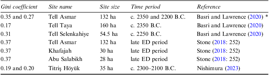
There are a number of studies that measure the degree of material wealth inequality for Mesopotamian cities (e.g., Basri and Lawrence Reference Basri and Lawrence2020; Bogaard et al. Reference Bogaard, Fochesato and Bowles2019; Nishimura Reference Nishimura2023; Squitieri and Altaweel Reference Squitieri and Altaweel2022; Stone Reference Stone, Kohler and Smith2018). Many of these works focus on the evolution of inequality across different periods and sites at the inter-regional level. Most of these multi-period and macro-scale studies agree that there was a general trend of increasing inequality from the Neolithic period to the Iron Age, especially within urban settlements.Footnote 8 During the late Early Dynastic period (hereafter ED, ca. 2500–2350 B.C.) and the subsequent Akkadian period (2334–2155 B.C.), available Gini coefficients—commonly employing house size as a proxy—indicate low to moderate levels of wealth inequality at urban residential neighbourhoods (Table 1).
Gini coefficients based on house size for mid-late third millennium B.C. urban sites in Mesopotamia; the closer the Gini value to 1, the higher the degree of economic disparity

* their Gini values for private dwellings at two occupation levels of Tell Asmar exclude palatial structures.
The Gini coefficients observed in Mesopotamian cities pose the question of whether wealth disparities were spatially manifested across residential areas within these cities. Through extensive excavations, urban neighbourhoods at Tell Asmar, Khafajah and Titriş Höyük in the mid-late third millennium B.C., as well as at Tell al-Muqayyar (ancient Ur) in the early second millennium B.C., revealed city streets and narrow lanes piercing through blocks of rectilinear and multi-roomed houses that shared party walls (Algaze et al. Reference Adams2001; Delougaz et al. Reference Delougaz, Hill and Lloyd1967; Woolley and Mallowan Reference Woolley and Mallowan1976). Surface and near-surface surveys using aerial photographs, magnetometry data and archaeological remains from other contemporary settlements, such as Tell Taya, Hamoukar and Tell al Hiba (ancient Lagash), also indicate similarly dense urban layouts with limited open spaces (Grossman Reference Grossman2013; McMahon et al. Reference McMahon, Pittman, Al-Zawi, Ashby, Burge, Goodman, Hammer and Pizzimenti2023; Reade Reference Reade1973).Footnote 9 Some researchers believe that, in such crowded environments, urban families of different economic statuses were spatially segregated (e.g., Henrickson Reference Henrickson1981; Nishimura Reference Nishimura2023), while others suggest that family groups of different economic levels were spatially mixed and lived side-by-side within the same neighbourhoods (Stone 2005: 145–148, Reference Stone and Crawford2013: 165–167; Truex Reference Truex2019: 41).
Tell Asmar and Khafajah in the Diyala Region
In the Diyala region, Tell Asmar, Khafajah and Tell Agrab were already large cities during the ED period (Adams Reference Adams1965: 38–39) (Fig. 1).Footnote 10 There was a period of widespread political fragmentation among city-states in the ED IIIb (ca. 2450–2350 B.C.) (Marchesi and Marchetti Reference Marchesi and Marchetti2011: 97). Subsequently, a major political unification of the city-states, including those in the Diyala region, occurred under the Akkadian hegemony.
Tell Asmar was approximately 132 hectares in the late third millennium B.C. (Basri and Lawrence Reference Basri and Lawrence2020: 692). In a northern section of the settlement, the excavations exposed an extensive living quarter containing numerous private houses (Fig. 5). No public buildings were discovered within this living quarter, and some of the houses were connected to stores facing an adjacent street (Delougaz et al. Reference Delougaz, Hill and Lloyd1967: 148). The occupation strata of these houses in this area span from the ED IIIb to the Late Akkadian periods (Henrickson Reference Henrickson1981; Gibson Reference Gibson1982, Reference Gibson, Miglus and Mühl2011).
Living quarter in the northern area of Tell Asmar, showing houses of Stratum Va (Courtesy of the Institute for the Study of Ancient Cultures, University of Chicago; original image from Delougaz et al. (Reference Delougaz, Hill and Lloyd1967: pl. 26), cropped by author)

Khafajah was approximately 30 hectares, and the excavations exposed fortification walls, temples and residential areas dating to the late ED period (Delougaz et al. Reference Delougaz, Hill and Lloyd1967: pl. 1). The excavated private houses were located at the highest point of the settlement mound adjacent to significant temples (Delougaz et al. Reference Delougaz, Hill and Lloyd1967: 20). The domestic occupation layers found in this area date from the ED II to the Early Akkadian periods (Henrickson Reference Henrickson1981; Gibson Reference Gibson1982, Reference Gibson, Miglus and Mühl2011). Between the ED IIIb and Early Akkadian periods, the so-called Walled Quarter was constructed through deliberate and centralised planning within this specific area (Delougaz et al. Reference Delougaz, Hill and Lloyd1967: 17–21) (Fig. 6). This is the only occupation layer and location where a well-planned central construction is evident at this site. Henrickson (Reference Henrickson1982: 16) acknowledges that the “obvious planning within the Quarter indicates some institutional agency was behind its construction.” In this area, an inner fortification wall, approximately 2.6 meters thick, encircled streets and houses. The streets within this rectilinear wall were long and straight, with one street extending over 35 meters, determining the alignment of the houses of various sizes interspersed with small structures of uncertain function (Delougaz et al. Reference Delougaz, Hill and Lloyd1967: 17). These construction schemes were new and different from the previous practices in this area, where new houses were built according to the pre-existing houses beneath them. Moreover, prior to the construction of the Walled Quarter, many houses contained burials beneath the floors. The houses within the Walled Quarter, however, did not contain intramural tombs.
Excavated residential area at Khafajah, showing Level 1 (the Walled Quarter) in solid black. The houses of Level 3 were excavated in the shaded areas (Courtesy of the Institute for the Study of Ancient Cultures, University of Chicago; original image from Delougaz et al. (Reference Delougaz, Hill and Lloyd1967: pl. 14), cropped and Level 3 shaded areas added by author)

Materials and Methods
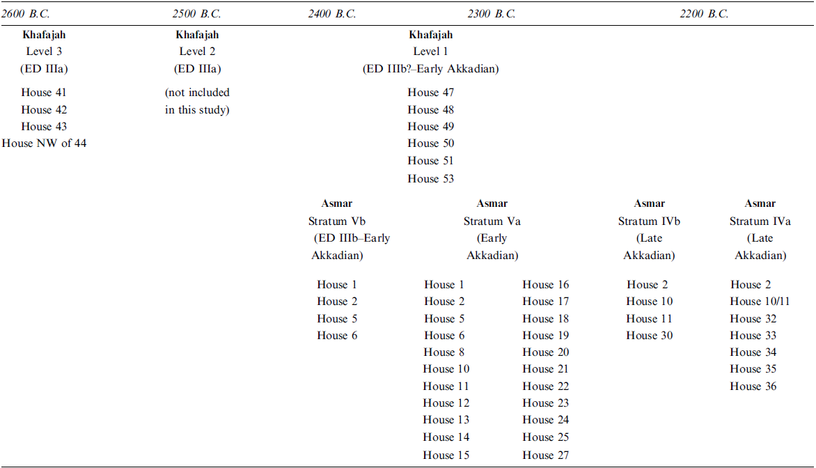
In order to assess the degree of wealth disparity among the private dwellings at Tell Asmar and Khafajah, I gathered data using the excavation report (Delougaz et al. Reference Delougaz, Hill and Lloyd1967) and the online database of the Diyala Archaeological Project at the Institute for the Study of Ancient Cultures, University of Chicago.Footnote 11 This work includes 47 houses that were fully excavated in the residential neighbourhoods at these sites (Table 2). At Khafajah, ten houses come from two separate occupation levels (Levels 3 and 1) within the same residential zone. In the Level 3 houses, five intramural burials were found beneath the floors. On the other hand, Tell Asmar yielded 37 houses from four different occupation strata (Strata Vb, Va, IVb and IVa), where no intramural graves were found within the private residences. The houses of Level 1 (the Walled Quarter) at Khafajah are roughly contemporaneous with those of Strata Vb and Va at Tell Asmar, dating approximately from 2400 to 2250 B.C. Other excavated houses from these sites were excluded from this analysis due to partial excavation or an insufficient number (<4) for comparison at a specific occupation level.
47 houses found in the residential neighbourhoods at Tell Asmar and Khafajah

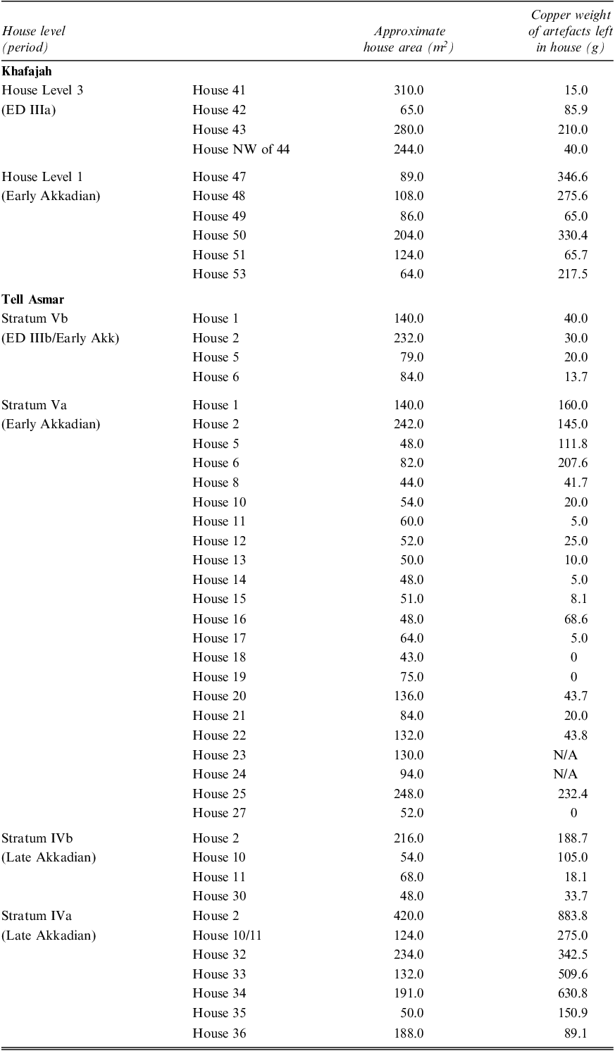
This work assumes that each of the economic variables required labour and financial investment by the house occupants who made, procured, or maintained it. As wealth proxies, I examined house areas and portable artefacts left in each house (Table 3). The sizes of the houses in square meters, including walls, were estimated by the excavators (Delougaz et al. Reference Delougaz, Hill and Lloyd1967: 276). The house areas range from 43 m2 to 420 m2, with an average of 124 m2. The use of house size as an indicator of wealth has been a common practice in analysing ancient settlements in the Near East (e.g., Basri and Lawrence Reference Basri and Lawrence2020; Squitieri and Altaweel Reference Squitieri and Altaweel2022; Stone Reference Stone, Kohler and Smith2018). The validity of the use of domestic artefacts as a wealth indicator has also been discussed in detail (Olson and Smith Reference Olson and Smith2016; Smith Reference Smith1987). However, because portable artefacts are more prone to preservation biases than architectural features, the Gini values derived from portable artefacts are expected to show variability. Domestic artefacts found in fragmentary condition were counted as complete objects as long as they were not from the same item. Two houses (H23 and H24) in Stratum Va at Tell Asmar were excluded from the artefact analysis because their floor levels were significantly disturbed, even though the sizes of these houses were traceable.
The two economic proxies at each house

Architectural features, household tools, personal ornaments and burial inclusions are all susceptible to depositional and preservation biases (LaMotta and Schiffer Reference LaMotta, Schiffer and Allison1999). These material remains must have undergone different formation processes during and after their use within the houses. While examining the preservation conditions in the occupation layers of the sites studied, excavators noted occasional disturbances caused by illicit diggers in certain rooms. To ensure a consistent analysis, this study excluded partially excavated houses and those with extensively damaged floors. For instance, the Level 2 houses in Khafajah were omitted due to the substantial damage caused by illicit diggers, resulting in too few excavated houses for meaningful comparison. Out of the 47 houses included in this study, there is a pattern of continuous rebuilding or repairing of walls and floors. A notable exception is a widespread abandonment, marked by a layer of ashes covering the ruins of Level 3 houses at Khafajah, showing a distinct break in occupation (Delougaz et al. Reference Delougaz, Hill and Lloyd1967: 13–15). Many houses fell into ruin due to abandonment, suggesting that the occupants likely took away valuable items upon leaving. Nonetheless, a substantial number of objects seem to have been misplaced, left behind, or forgotten by the occupants within the houses, as evidenced by several buried silver hoards found in some houses. To minimize bias from variable preservation, the household data in this study were retrieved from primary floor levels. More than one floor level was found in some of the occupation levels. I utilized two distinct economic proxies to detect discrepancies and biases in preservation between the different lines of evidence. This study, therefore, is based on the premise that the material culture preserved and unearthed from the floor levels is not entirely random and reflects differential access of the occupants to material wealth.
Regarding domestic artefacts as an indicator of wealth disparity, Stone (Reference Stone, Kohler and Smith2018: 255) proposes an insightful method for comparing approximate values across different artefact types in numerical form. This method incorporates the relative value of gold, silver and copper, as provided by Snell (Reference Snell1982: 146–150) based on textual data from the Ur III period. Given that Mesopotamians had to import these metals, they were often the most valuable objects in houses of commoners. According to Snell, the ratio of the value of gold, silver and copper was 1:10:1100. However, because silver and gold items—mainly small rings and earrings—are rarely found in the Khafajah houses, using the 1:110 silver-to-copper ratio significantly distorts the picture of distribution of material wealth among these households. Additionally, many of the objects listed as copper at Bronze Age Mesopotamian sites, including Tell Asmar and Khafajah, might actually be made of bronze alloy. Given the aim of the assessing wealth disparity among houses across different occupation layers, therefore, I employed a modified version that retains the 1:10 gold to silver ratio but assigns silver to 11 times more value than copper, rather than using the 1:110 ratio. Common copper artefacts left in the houses at Tell Asmar and Khafajah include pins, bracelets, rings, earrings, daggers, bowls and various small tools.
Since the weight and size of the artefacts from the Tell Asmar and Khafajah houses are largely unavailable, I employed Stone’s method using the average weight of common metal artefacts, as calculated for objects in graves at Ur and Abu Salabikh dating to the middle centuries of the third millennium B.C. (See Supplemental Material, Appendix A). Based on the average weights of typical objects and the 1:10:110 ratio of gold, silver and copper, metal artefacts at the Tell Asmar and Khafajah houses were converted into their copper equivalent weight (See Supplemental Material, Appendix B). When the mean weight for a specific type of metal artefact was not available, an available mean weight of a similar-sized copper object, such as a copper blade/knife for a copper sickle, was applied. At Tell Asmar, two metal items from Stratum Va (1 lump of silver and 1 hoard of silver ornaments) and 24 items from Stratum IVa (1 copper ingot, 2 links of copper chain, 1 piece of silver with gold decoration, 1 bit of silver wire, 1 group of copper implements, 12 twisted silver ornaments, 4 silver ornaments and 2 lumps of silver) were excluded from analysis due to the lack of even approximate sizes for these items. The exclusion of these items, especially in Stratum IVa, might have affected the assessed degree of economic disparity.
In addition to metal objects, typical portable artefacts found within the houses and their intramural tombs include pottery, cylinder seals, containers, weights, beads and amulets, all made from clay, stone, bone or shell (See Supplemental Material, Appendix C). Because size, weight and value information were unavailable, it was not possible to estimate the relative values of these different types of non-metal artefacts. These household possessions include imported lapis lazuli or carnelian amulets and beads as well as labour-intensive or value-added products, such as stone bowls and cylinder seals. Many of these items were likely more valuable than small copper ornaments or tools. By assuming that an average value of all the different types of non-metal artefacts might have been slightly higher than that of a simple copper ring, I assigned a relative value of 5g in copper weight to all the different types of non-metal artefacts at Tell Asmar and Khafajah.
The Gini coefficient index was optimal for this study as it is well-suited for illustrating material wealth inequality within individual sites. While there are other measures of wealth disparity, such as Theil and Robin Hood indexes, this study does not require the inclusion of factors such as wealth redistribution, adjustments to equalize wealth, or consolidation among multiple sites or regions. While the Gini coefficient quantifies the extent of inequality, it does not reveal specifics about how inequality manifests or evolves within a society. The Lorenz curve, which underlies the Gini coefficient, facilitates the visualization of wealth distribution, at least concerning population proportions. When combined with relevant literature, it sheds light on the form of wealth disparity within each site or occupation stratum.
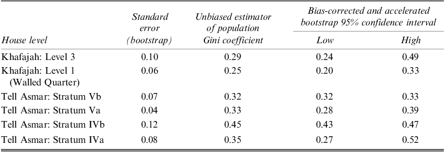
Using the Gini module in StatsDirect as a computing tool, I calculated unbiased estimators of the population Gini for the two economic proxies (house size and copper weight) and compared the degrees of material wealth disparity between the different occupation levels at Tell Asmar and Khafajah. I used a bootstrapping method with 100,000 replicates and attached error ranges to the Gini coefficients due to the limited sample size. This method increases confidence at a 95 percent level by widening the range of possible Gini values. Nevertheless, some comparisons of Gini values between house levels remain tentative since only four houses were exposed for comparison at each of Level 3 in Khafajah and Strata Vb and Vb in Tell Asmar. The use of the Lorenz curve supplements the Gini coefficient, illuminating the distribution of the wealth share among the houses.
Results
Gini values based on the house areas range from 0.25 to 0.45, with an average of 0.33 (Table 4 and Fig. 7). The lowest Gini value (0.25) is observed for Khafajah Level 1, followed by 0.29 for Khafajah Level 3. In contrast, the occupation layers at Tell Asmar exhibit slightly higher Gini values (0.32, 0.33, 0.45 and 0.35). The Gini value (0.45) of Tell Asmar Stratum IVb is considerably high. At this level, despite the relatively high standard error (0.12), the bootstrap range at a 95 percent confidence level remains narrow (0.43–0.47). The bootstrap ranges for Khafajah Level 3 and Tell Asmar Stratum IVa stretch more widely (0.24–0.49 and 0.27–0.52). At Khafajah, it is noticeable that the Gini values slightly decline from Level 3 to Level 1, whereas the values slightly increase over time at Tell Asmar.
Gini values based on house areas

Gini values at each occupation level; Gini values based on house areas are shown within grey bars indicating bootstrap ranges, while those derived from the total copper weight of artefacts are shown within white bars

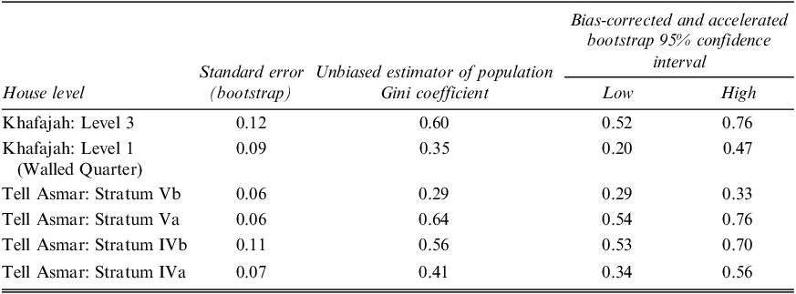
As anticipated, the Gini values based on artefacts exhibit significant variability, making it difficult to discern the underlying pattern. The values range from 0.29 to 0.64, with an average of 0.48 (Table 5 and Fig. 7). The lowest Gini value (0.29) is for Tell Asmar Vb, followed by 0.35 for Khafajah Level 1. The Gini values for this wealth index consistently surpass those derived from the house areas across the occupation levels, except for Tell Asmar Stratum Vb, where the Gini remains low (0.29). The preservation bias towards portable artefacts must be partially responsible for the high levels of apparent material wealth disparity in this category. The high values are particularly observed at Khafajah Level 3 (0.60) and Tell Asmar Strata Va (0.64) and IVb (0.56). At Khafajah, there is a significant drop in the Gini values from Level 3 to Level 1, whereas the values fluctuate over time at Tell Asmar. The bootstrap shows relatively wide ranges for all occupation layers, except for Tell Asmar Stratum Vb. However, it is noticeable that the level of wealth disparity is lower at Khafajah 1 and Tell Asmar Stratum Vb compared to other occupation levels.
Gini values based on total copper weight of artefacts

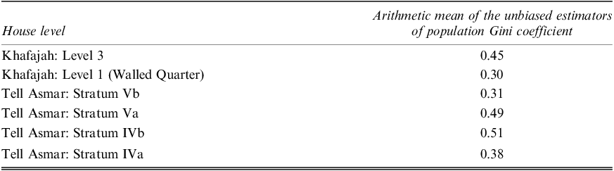
Table 6 presents the mean Gini values when the results of the two economic proxies are combined. I calculated the arithmetic means of the unbiased estimators of the population Gini at each occupation level. The arithmetic mean of the Gini values across the occupation levels is 0.41. The means confirm the notable drop in Gini values from Khafajah Level 3 to Level 1. These means also illustrate an increasing trend followed by a decrease over time at Tell Asmar.
Mean Gini values between the two economic proxies

The Lorenz curves, which form the basis for the Gini values, visualize the wealth share against certain percentiles of the population. On a Lorenz curve graph, a straight line represents a perfectly equal distribution of wealth across a population, while a curved line depicts the actual distribution of wealth within the population. When the curved line deviates farther from the straight line, it depicts a more unequal distribution. The shape of the curved line indicates what percentile of the population holds what percentile of the total wealth present within the population.
At Tell Asmar and Khafajah, the Lorenz curves derived from the house areas generally display a more or less proportionate deviation from the line of complete equality across the population. For instance, while the Gini value at Tell Asmar Stratum Va is 0.33, the corresponding Lorenz curve indicates that the wealth difference is evenly spread across the population (Fig. 8). This suggests that the wealth inequality indexed by the Gini value was in a continuum and was not strongly associated with a specific percentile of people whose wealth stood out significantly from the rest of the population. On the other hand, some of the Lorenz curves based on the domestic artefacts exhibit substantial deviations from the line of complete equality. These deviations are particularly noticeable at Khafajah Level 3 and Tell Asmar Strata IVb and Va. For example, at Tell Asmar Stratum Va, around 70 percent of the houses held only about 20 percent of the excavated artefacts from this occupation level. This means that the majority (80%) of the artefacts were concentrated within approximately 30 percent of the houses (Fig. 9). At Tell Asmar Stratum Va, the difference between the more proportionate deviation seen in houses sizes and the wider deviation based on artefacts implies that the distinct economic indicators illuminate varying patterns of wealth and biases in preservation.
Lorenz curve derived from the house areas at Tell Asmar Stratum Va (n=22 houses), showing a more or less proportionate deviation from the line of complete equality across the population

Lorenz curve derived from the domestic artefacts at Tell Asmar Stratum Va (n=20 houses), showing a significant deviation from the line of complete equality across the population

Discussion
At Khafajah, the findings showing a decline in wealth disparity support the idea that centrally planned construction is associated with economic homogenisation among residents. The houses in the ED IIIa period (Level 3) display greater material wealth inequality than those of the subsequent ED IIIb–Early Akkadian period (Level 1), coinciding with the establishment of the Walled Quarter through the architectural reconfiguration of the area. Within the Walled Quarter, both of the wealth variables point to a noticeable decrease in wealth disparity compared to the prior period, suggesting a community of people with similar economic status.
When comparing these results with those of the contemporary residential neighbourhood at Tell Asmar, different patterns emerge that reveal an unequal wealth distribution. While the wealth gap, as indicated by house sizes, is more pronounced in the Tell Asmar neighbourhood compared to the Khafajah Walled Quarter, the former also shows a growing trend over time. The distribution of household artefacts at Tell Asmar shows a different pattern. At Tell Asmar Stratum Vb, the wealth disparity based on house areas was slightly higher than that of Khafajah Level 1. When calculated based on the domestic artefacts, however, it is comparable to Khafajah Level 1. Subsequently, wealth disparity in Tell Asmar significantly increases. In particular, the high degree of inequality among the houses dating to the Early Akkadian period (Stratum Va) stands out from that of the other phases. This high inequality level gradually decreases in the subsequent Late Akkadian period (Strata IVb and IVa) in Tell Asmar, although the reduced wealth discrepancy in the last occupation phase remains higher compared to the Khafajah Walled Quarter. The substantial economic disparity seen in domestic artefacts during the Early Akkadian period at Tell Asmar contrasts with the consistently low measurements observed in the contemporary houses within the Khafajah Walled Quarter.
This contrast likely stems from the fact that the Walled Quarter was intentionally planned with a specific purpose, whereas the residential area at Tell Asmar was a product of organic growth over time. Previous studies addressing who resided in the Walled Quarter allude to a collection of people with distinct social traits. It is unclear who the residents were and what the significance of the thick inner walls was, especially considering that the city already had outer fortification walls. Researchers believe that due to its location at the highest point of the settlement, adjacent to the important city temples, this area was an affluent and elite neighbourhood throughout its history of occupation (Delougaz et al. Reference Delougaz, Hill and Lloyd1967: 18; Henrickson Reference Henrickson1981: 78). Delougaz and colleagues (Reference Delougaz, Hill and Lloyd1967: 20) posit the possibility that the Walled Quarter might have been occupied by external conquerors and was built as a top-down project for protection against the city’s local inhabitants. They suggest that the residents, different people from those of the rest of the city proper, constructed a military garrison for self-protection in this prominent section. On the other hand, Henrickson (Reference Henrickson1982: 19) interprets the Walled Quarter as socioreligious segregation, separating a sanctified neighbourhood from more mundane areas of the city. Archaeological findings indicate that the private residences within the Walled Quarter closely resemble houses outside this section (Henrickson Reference Henrickson1982: 17). Therefore, Henrickson concludes that wealthy religious officials likely inhabited the large houses while less important temple staff resided in the smaller houses within this newly reconfigured section of the city.
Conversely, there is no trace of pre-planned design or centralised construction in the contemporary living quarter at Tell Asmar throughout its occupation history. In the Tell Asmar neighbourhood, the gap between affluent and less affluent households widened after the ED IIIb period, reaching its peak during the Early Akkadian period. In fact, this occupation phase is considered as a period of economic decline, as the houses from the preceding era were divided into smaller dwelling units in this area (Delougaz et al. Reference Delougaz, Hill and Lloyd1967: 166; Henrickson Reference Henrickson1981: 50). The excavations revealed houses with diverse architectural layouts, some of which were small and inadequately planned. These economic conditions, along with the observations from the Lorenz curve, suggest that a majority of the inhabitants might have experienced a degree of poverty during this period. However, a few houses contained caches of silver items, such as a lump of silver found in House 1 and a hoard of silver ornaments in House 20. The increased economic difference was gradually reduced during the Late Akkadian period, although it did not reach the low level seen in the Walled Quarter.Footnote 12 In contrast to the Early Akkadian period, the abundance of silver objects found in many houses, coupled with the reduced wealth disparity, indicates an improvement in living conditions at Tell Asmar during the Late Akkadian period.
Methodological Implications
This study emphasizes the importance of employing various indicators to measure material wealth among excavated houses. As the main indicator of comparable household wealth, many archaeological studies rely on the size of residential structure, especially floor area. Other economic proxies include burial architecture, grave goods, domestic storage capacity, labour cost and material volume for house construction, as well as built-in features and portable artefacts found in houses. It is crucial to cross-reference multiple variables, because different variables may reflect different social factors and preservation biases rather than material wealth. Other scholars have observed discrepancies among different economic measures and underline the necessity of employing multiple proxies (Ames Reference Ames, Bentley, Maschner and Chippendale2007; Ames and Grier Reference Ames and Grier2020; Chase Reference Chase, Chase and Chase1992: 122; Hutson Reference Hutson and Hutson2016: 153; Schulting Reference Schulting1995: 21; Woolley Reference Woolley1954: 189; Woolley and Mallowan Reference Woolley and Mallowan1976: 38).
For instance, there appears to be a tendency for portable artefacts to exhibit somewhat higher Gini values than house areas. This difference can be partially attributed to the susceptibility of portable artefacts to preservation biases. In the city of Titriş Höyük in northern Mesopotamia, the centrally planned construction of the residential areas took place at around the same time as that of Khafajah. Although there were not enough excavated earlier houses to compare the economic composition before the planned construction at Titriş, the rich archaeological data shed light on the similar economic status among the houses constructed through centralised planning (Nishimura Reference Nishimura2023). At this site, the mean Gini value derived from the house areas is 0.20, while the mean from the domestic artefacts is 0.30. This tendency of slightly higher Gini values for portable artefacts compared to the house areas is also evident in the results from the Khafajah Walled Quarter, where the Gini values for these economic indicators are 0.25 and 0.35 respectively.
Research has also indicated that grave goods often show higher levels of economic disparity than those based on house sizes (Fochesato et al. Reference Fochesato, Bogaard and Bowles2019: 860; Porčić Reference Porčić2019: 374; Smith et al. Reference Smith, Dennehy, Kamp-Whittaker, Colon and Harkness2014: 313; Stone Reference Stone, Kohler and Smith2018: 255–256). The oddly high degree of disparity from grave goods is possibly due to the fact that burial data represent individuals, whereas house data reflect households as the unit of analysis (Fochesato et al. Reference Fochesato, Bogaard and Bowles2019: 860; Porčić Reference Porčić2019: 374; Smith et al. Reference Smith, Dennehy, Kamp-Whittaker, Colon and Harkness2014: 313).Footnote 13 At Khafajah, a Gini value of 0.74 was derived from grave goods within the Level 3 houses, closely resembling the notably high measurement (0.77) calculated for this site by Stone (Reference Stone, Kohler and Smith2018: 252). However, the 95 percent probability range for the Level 3 houses, spanning from 0.33 to 1.0, lacks statistical significance. This lack of significance is partly attributed to the limited sample size (4 houses) at this occupation level and the absence of tombs in two of these houses.
This type of comparative research utilising multiple economic variables is feasible only with a fine-grained excavation record of residential floors from numerous contemporaneous and horizontally excavated houses within an urban neighbourhood. Many excavations and their resulting publications do not separate findings between primary floor contexts and secondary ones, or they do so for only a few sample houses.
Conclusion
This study explored the possible correlation between centralised planning and the clustering of residents with similar economic status within ancient urban residential contexts. This correlation was assessed based on the archaeological records from two excavated areas within the third millennium B.C. cities of Tell Asmar and Khafajah, located in central Mesopotamia. The excavations exposed numerous houses within the two residential neighbourhoods, including an occupation layer, the Walled Quarter, at Khafajah, which displays a well-structured construction project dating to around 2400–2300 B.C. Using the Gini coefficient and the Lorenz curve indexes, the results indicated that the residents of the Walled Quarter exhibited a slightly higher degree of wealth similarity compared to residents of other occupation levels at these sites. Further exploration of this correlation should involve larger datasets from horizontally excavated houses in ancient cities worldwide.
It remains unclear why the pre-planned construction of the Walled Quarter coincided with the rise and expansion of the Akkadian rule. The centralised planning yielded similar-sized houses and enclosed them within the thick walls, while the tradition of burying the deceased beneath the floors was discontinued within these houses. Located in proximity to the Akkadian headquarters at Agade, many sites in the Diyala region show numerous traces of the presence and influence of the Akkadian state (e.g., Gibson Reference Gibson1982). The defensive purpose of the city planning at Titriş Höyük has also been suggested, due to the newly built fortification wall and the complete abandonment of previously settled areas outside the city proper (Lancaster and Matney Reference Lancaster and Matney2023: 12). Hence, it is surmised that this planned construction at Khafajah is linked to the rise and impact of the Akkadian hegemony on provincial cities in Mesopotamia. It may represent a local response to the imminent threat by the territorial sovereign state. The collective goal of self-defence might have led to the clustering of residents with similar economic traits within the settlement areas.
Supplementary material
To view the supplementary material for this article please visit https://doi.org/10.1017/irq.2024.14