

Introduction
In June 1948, the flag of the newly independent Republic of the Philippines was hoisted over the white coralline sands of Taganak Island, the largest island in the Turtle Island shoal.Footnote 2 As seven small tropical islands in the Sulu Sea segmenting the Philippine Archipelago from the northern coast of Borneo, the Turtle Islands had existed in a state of transnational limbo for decades. Caught between imperialisms, and obscured in poorly drawn colonial maps, the Turtle Islands were, in the colonial mind-set, amongst the most isolated points of both British and American territorial control. It was this imperial fault-line that British and American diplomats demarcated as the respective limits of their empires in January 1930.Footnote 3 The Turtle Islands belonged to the United States, yet they were to be administered ad infinitum by the British North Borneo Company, in turn a British imperial protectorate. Seen by colonials as one of the most remote places on the planet, Borneo had been caricatured in the colonial imagination as a terra incognita comprising limitless jungles, unforgiving mountains and man-eating animals (Tagliacozzo Reference Tagliacozzo2013: 63).Footnote 4 Similarly, the Sulu Sea between Borneo and the southern Philippines was cast as an ill-defined expanse of ocean riddled with pirates, volatile currents and jagged rocks. Despite this supposed danger, the Turtle Islands had long served as a transit point for traders, fishermen and smugglers seeking turtle eggs, coconuts and fish. In the late nineteenth century, the islands became a hotspot for vacationing colonials eager to experience tropical splendour.
When the North Borneo Company constructed a lighthouse on Taganak Island's small volcanic summit in 1923—a vantage point 148 metres high that on clear days granted an unobscured view of the surrounding water—they sought to bring navigational signalling, maritime security and colonial order to the sea. Colonial authorities hoped to illuminate the coastline and thereby ward ships away from the small reefs and jutting rocks that dotted the Sulu Sea. Yet for centuries, perhaps even millennia, myriad ocean craft had journeyed these waters successfully. Indigenous Bajaus, Suluks and so-called ‘sea Dayaks’ had long ferried goods and ‘jungle produce’ back and forth across the Sulu Sea (see Cleary Reference Cleary1996: 302; Harper Reference Harper1997: 7). Malay, Chinese and even Arab traders had gained wealth plying their trade and extracting resources from the Bornean mainland.Footnote 5 It was a bustling, global waterway. Yet in the colonial imagination, an alternate picture of barrenness, danger and isolation surfaced and shaped administrative policy over the years.
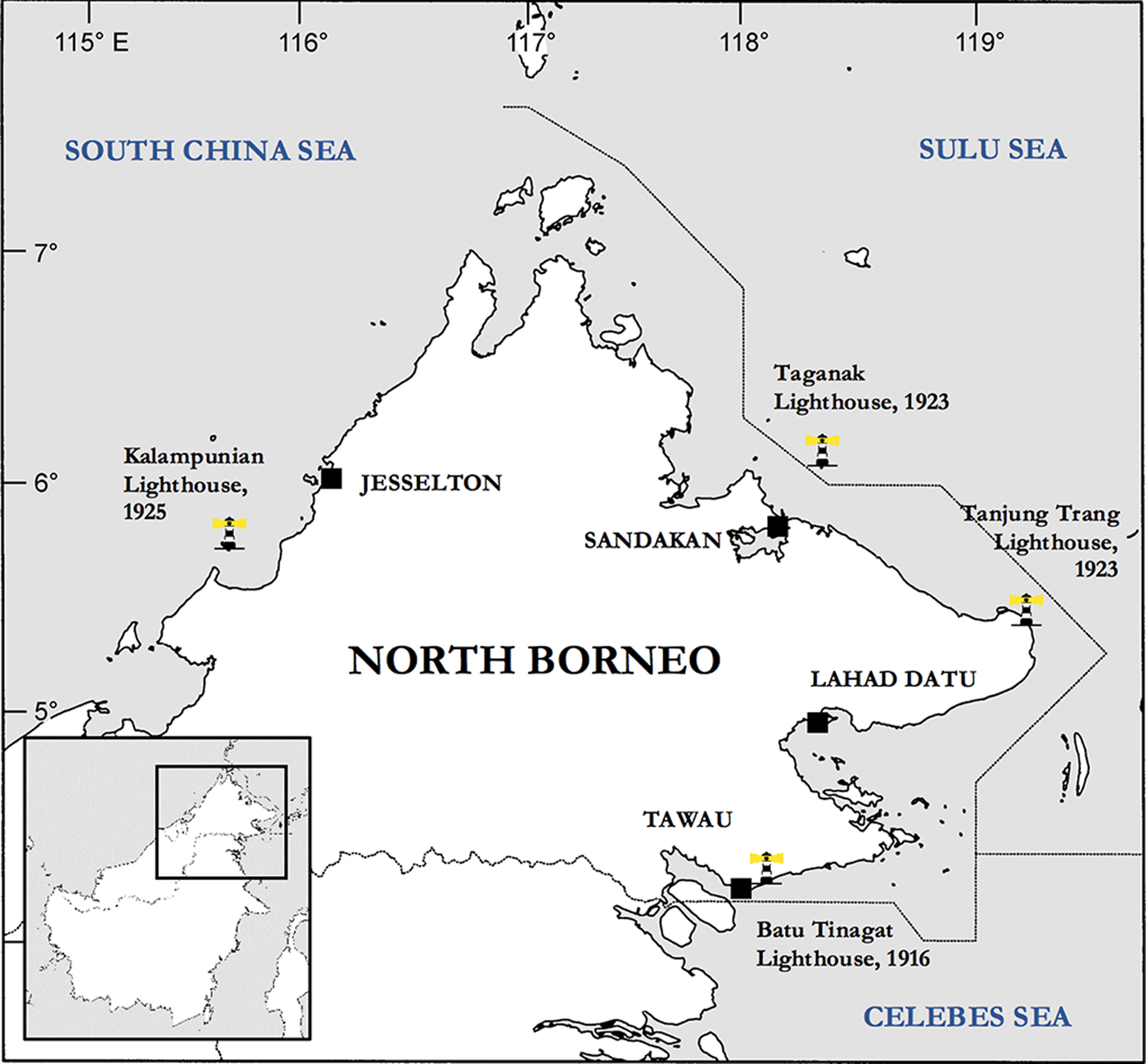
In many ways, lighthouses facilitated maritime empire. Along the Chinese coast, imperial lighting had illuminated similarly perilous waterways and secured Western colonial shipping from Hong Kong to Shanghai and beyond since the 1860s. By 1948, over 300 lighthouses and other navigational beacons had been constructed in the region (Bickers Reference Bickers2013: 432). Similar patterns of imperial illumination occurred across maritime Southeast Asia, particularly around the Malay Peninsula. As large portions of once-unknown coastline were gradually charted by the 1870s and 1880s, colonial states constructed lighthouses to facilitate their ever-expanding networks of trade (Tagliacozzo Reference Tagliacozzo2005: 310). The North Borneo Company, however, was slow to engage in illuminating its coast: it was only in 1916 that they first erected a lighthouse.Footnote 6 Following the construction of this beacon at Batu Tinagat, near the eastern port of Tawau, a fragmented network of lights followed, spanning from Tanjung [Cape] Trang and Taganak Island in the northeast (both built in 1923), to Kalampunian Island in the west (1925).Footnote 7 The lighthouse at Taganak, however, was built on contested territory, projecting a stark colonial presence across the Sulu Sea.
By the time the Philippines transitioned to independence on 4 July 1946, and by the time the State of North Borneo was formally colonised by Britain days later, on 15 July, regional acceptance of the necessity for a colonial guiding presence in the sea had begun to unravel.
This article examines this colonial versus post-colonial dichotomy, along with transnational perceptions of island sovereignty and lighthouse obligation amidst the end of empire in Southeast Asia. Through analysis of the transfer of administration of the Turtle Islands to the Philippines, and the subsequent dispute over the Taganak Island Lighthouse, it argues that both Britain and North Borneo's colonial administration had a crippling laxity concerning issues of island sovereignty. The first part of the article will consider the factors that contributed to such colonial practices and perspectives, contending that the vague and poorly-defined maritime boundaries set between colonial powers reflected a stark administrative complacency prior to decolonisation. The second part will explore the escalation of Anglo-Philippine tensions between 1946 and the island transfer in late 1947, arguing that this was caused on the one hand by the continuation of age-old perceptions of colonial predominance, and by the Philippine desire to assert a greater sense of autonomy and regional status on the other. The final section will evaluate the ramifications of the island transfer. Through the examination of first-hand accounts of the handover ceremony, along with Philippine and British records, it will be possible to attain a more nuanced understanding of competing notions of island sovereignty and the ways that post-colonial states strove to manoeuvre themselves amidst a world still dominated by stubborn—and sometimes bewildered—decolonising powers.
Origins: Colonial Laxity and Post-Colonial Rumblings
The notion that Britain would someday have to lose or relinquish its colonies did not enter deliberations when American and British diplomats met in Washington, DC, in January 1930 to discuss the maritime boundary segmenting their territories.Footnote 8 Official records paint a picture of confidence and a desire to iron out cartographical ambiguities along inter-imperial borderlines. The aim was to consolidate empire at its extremities: a world of multifarious coastlines and sporadic tropical islands that had long resisted foreign colonial rule. While the 1930 convention demarcated the respective limits of American and British imperialism in maritime Southeast Asia, it caused longstanding confusion and left questions unanswered. In fact, it prompted no material or administrative changes on the ground, whilst serving to obfuscate who the real, long-term rulers really were.
Major lighthouses constructed by the North Borneo Company between 1916 and 1925. Note that following the 1930 Anglo-American boundary convention, the Taganak Lighthouse was located within Philippine territorial waters. While each of the colony’s major ports was relatively near to a lighthouse, vast stretches of coastline were not illuminated.

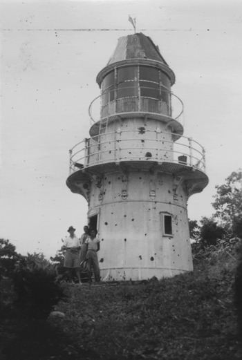
Early photograph of the Batu Tinagat Lighthouse, near the port of Tawau, c. 1920s. No such photographic records of the Taganak Lighthouse are known to exist, but the structure would have been similar what is depicted here.

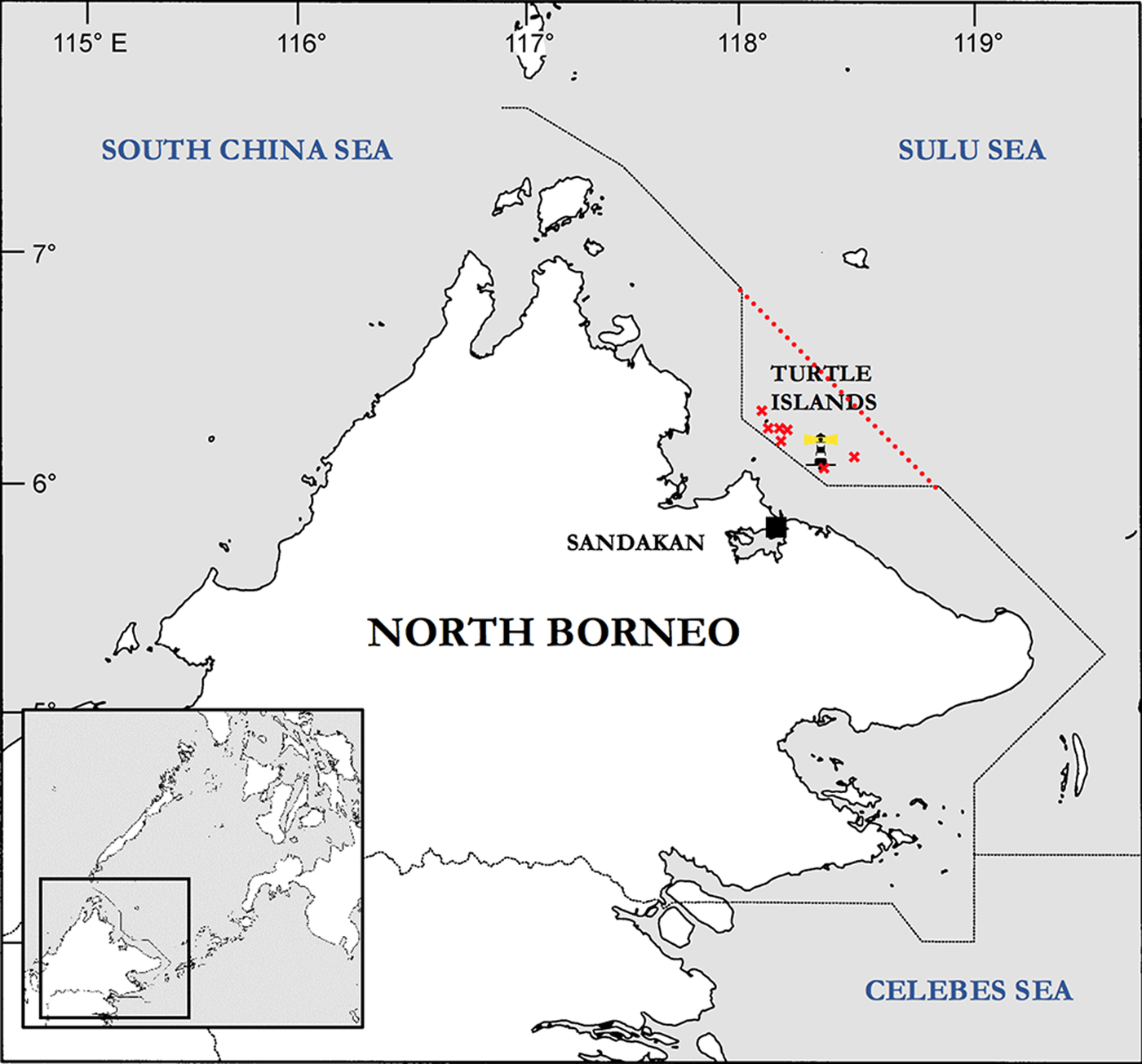
Underlying notions of imperial permanence—especially in the British context—compelled diplomats and administrators to leave complex irregularities to the future. It was agreed that Britain could continue to utilise and administer the Turtle Islands “in perpetuity,” or until the United States decided to assume control, which would have triggered a specified year-long transfer process. The language utilised in the agreement—emphasising permanence and stability—symbolically echoed the late-nineteenth-century treaties signed with indigenous leaders during the initial annexation of North Borneo. When German diplomat Baron Gustav von Overbeck first purchased the territorial rights for North Borneo from Jamal ul-Azam, the then-sultan of Sulu in 1878, it was leased to him “until the end of time” (Nisperos Reference Nisperos1981: 73). A similar notion of permanence—an agreement of “perpetuity” guaranteed by co-imperial understanding—bred the sense of colonial complacency back in London. It correspondingly generated a false sense of security for Company officials in North Borneo. As they saw it, why would the United States seek to regain costly administrative duties over a series of small islands that were, after 1930, clearly demarcated on world maps as American territories? The United States had the territorial prestige associated with owning the islands without having to worry about day-to-day administration on the ground. From the American perspective, another government was paying for the upkeep of the lighthouse at Taganak Island, costly anti-smuggling patrols were taken care of, and the small island communities were otherwise virtually self-sufficient. Likewise, the United States lacked any long-term cultural ties to the Turtle Islands, and as they were deemed to be of little economic value, colonial administrators on both sides felt that they had struck a balance (Tarling Reference Tarling1978: 300–302).Footnote 9
Map showing the post-1930 maritime boundary between North Borneo and the Philippines, with the original (pre-1930) line. The location of Taganak Island is denoted by the lighthouse symbol, and the rest of the Turtle Island shoal is marked around it.

Two years earlier, the United States and the Netherlands had been locked in a sovereignty dispute over the island of Palmas, a small and sparsely populated territory in the seas between Mindanao and the Celebes (Sulawesi). A precedent was set on 4 April 1928 when the Permanent Court of Arbitration at The Hague ruled that, despite American assertions that they had derived sovereignty from historical Spanish acquisitions (which they claimed to have inherited in 1898), the island was a Dutch territory (Haller-Trost Reference Haller-Trost1998: 120; Lotilla Reference Lotilla2016: 17). The United States had argued that their inherited historical claims were valid, first because the island had been discovered by Spanish explorers in the sixteenth century, and second in accordance with the “principle of contiguity,” which implied that “a small island is part of the territory of the nearest continent or large island.” The Court rejected both arguments and awarded the Netherlands sovereignty on the basis of its “continuous and peaceful display of state authority over the island” since the late seventeenth century.
When compared to the agreements subsequently reached between British and American diplomats in January 1930 concerning sovereignty over the Turtle Islands, the similarity of the issue—small, contested islands caught between vast, overlapping imperial systems—is indeed striking. Despite the North Borneo Company having displayed a vague sense of ‘state authority’ over them in one form or another (evidenced by the North Borneo Company's anti-smuggling patrols, and after 1923 through operating the lighthouse), and even though they were geographically much closer to Borneo than to the Philippines, it was agreed that the Turtle Islands were American territories. The British government, operating on behalf of the Company, did not contest the American claims. Lax colonial attitudes meant that administrative ambiguities were left to the future. Yet just eight years earlier, in 1922, these same islands were deemed by the North Borneo Company to be “of Imperial importance” (Tarling Reference Tarling1978: 310). Fears were raised that the “strategic value of North Borneo will be gravely imperilled if not destroyed” if the islands were to fall into foreign hands (Tarling Reference Tarling1978: 310). Such concerns were ignored by the metropole, and Britain allowed the islands to transition into a state of trans-imperial limbo.
The years preceding the Second World War were accordingly reflective of a period of British colonial laxity and complacency concerning Company-administered North Borneo, and this was particularly evident regarding foreign policy matters in the Sulu Sea region. This was exacerbated by the functional separation between Britain and the autonomous Company. After extending official protection to North Borneo in 1888, the Company was prevented from engaging in any form of foreign policy.Footnote 10 This placed the Turtle Islands in an ambiguous situation, whereby it was unclear whether they fell within the autonomous Company's remit or that of formal imperial administration. If Britain had really sought to enforce the Company's ownership of the islands, they could have adhered to a similar line successfully utilised by the Dutch in 1928. American colonial administrators, despite deriving sovereignty from historical Spanish claims, had never actually set foot on the islands. Even though no formal contact or authority had been imposed prior to the lighthouse's construction in 1923, demonstrations of indigenous ownership were disregarded. As the “dual colonial overlords” of Borneo, the Dutch and the British faced many of the same regional pressures over the years (Tagliacozzo Reference Tagliacozzo2013: 63). Yet they responded in different ways: Britain's colonial presence in Borneo was indirect and marked by the autonomous nature of the Company government until formal colonisation in 1946.
The geopolitical irregularities created in 1930 ultimately represented a culmination of factors that had over the years mitigated the perceived foreign threats to British imperialism in the region. Amongst these factors was the removal of external pressure posed by competing Western empires. For centuries, imperial powers had vied for greater influence in Southeast Asia, and the gradual emergence of de facto British interests in Borneo (at first following James Brooke's colonisation of Sarawak in 1841, and subsequently the formation of the North Borneo Company in 1881), threatened Spain's regional dominance. This changed in the late nineteenth century, with the withdrawal of Spain's territorial ambitions in Borneo following the signing of the Anglo-Spanish-German Treaty in 1885, Britain's decision to grant formal protection over North Borneo in 1888, and the Treaty of Paris in 1898, which resulted in the American colonial takeover of the Philippines (Wright Reference Wright1972: 71). Unlike Spain, which had historically sought to extend influence into the Bornean mainland, the United States did not harbour such territorial aims (see Gould Reference Gould1969: 63–64; Tregonning Reference Tregonning1954: 357–372).Footnote 11
With its external threats ostensibly nullified, and a veil of protection offered by the metropole, the North Borneo Company's administrators focused on extending colonial ideas of order and ‘civility’ across the territory's vast hinterlands. Networks of small bridle paths and eventually railways were gradually carved into the dense jungles (Kaur Reference Kaur1994: 8–9). By the turn of the twentieth century, North Borneo was on the peripheries of empire, and to colonials, seemingly far from the world's more pressing geopolitical threats. This played into colonial notions that Borneo represented an unforgiving world of dense rainforests and unknown savagery, somewhere so ungovernable that it was not subject to conventional foreign policy pressures. By ignoring its vibrant history of indigenous states and networks of trade and migration, colonials cast it as peripheral, especially in comparison to ports such as Hong Kong and Singapore. This contributed to a sense of security and accord regarding North Borneo's geopolitical positioning in Southeast Asia, even if its hinterlands and surrounding seas were perceived as being eternally dangerous. Doubts about external maritime security were dismissed by the metropole; only questions of imperial order and navigational lighting were deemed necessary to counter indigenous disorder, piracy and nautical darkness.
Many have remarked at the ease with which the Japanese occupied the various Western colonial possessions across Asia in late 1941 and 1942. Some foreign observers at the time felt that the fall of Singapore was reflective of the “scant loyalty [of the indigenous communities] towards their colonial masters” (Reece Reference Reece2011: 9). There was also a lack of effort from the imperial powers: when the Japanese stormed North Borneo's port of Jesselton in January 1942, for instance, the small British defence force had already surrendered and laid down their arms. For Britain and the North Borneo Company regime, this marked a calamitous return to the traditional geopolitical threats that had dominated and shaped inter-imperial dealings in the nineteenth century. A false sense of security in maritime Southeast Asia—especially in the seas between Borneo and the Philippines—was perpetuated by treaties such as the 1930 boundary convention, which left in their wake confused colonial agreements of implicit trust and accord. Caught in the path of Japan's southward advance, the Taganak Lighthouse was the first Company structure damaged as the invasion force passed through the Turtle Islands on the morning of 19 January 1942, before making landfall hours later at North Borneo's capital of Sandakan (London Gazette 1948: 1284).
By July 1946, the new British administrators in North Borneo had to scramble to establish formal control over a territory that had endured 60 years of negligent Company rule and a period of calamitous wartime occupation. While orthodox histories have tended to favour the North Borneo Company—with some describing its tenure as benevolent and “eminently satisfactory”—its governing doctrine was dominated by profit-minded expedience that neglected indigenous rights (Tregonning Reference Tregonning1958: 213). Infrastructural, medical and social projects were sorely lacking. After the Second World War, administrators in North Borneo were faced with perhaps “the most devastated territory in the British Empire apart from Malta” (Phillips Reference Phillips2016: 1007). At the port of Jesselton, only three structures remained standing (Granville-Edge Reference Granville-Edge1999: 73). Chief Oman, of Kampung Benoni in the west coast's Papar District, for instance, claimed that “everything was habis [finished, devastated or ruined]” (Brooks Reference Brooks1999: 149). A lack of public spending and the relative impoverishment of the Company administration meant that, unlike Hong Kong or Singapore, North Borneo's trading ports consisted solely of small, wooden structures and private dwellings (O.B. 1937: 9). Virtually all of these were razed during the war: neither Sandakan nor Jesselton had sturdy buildings adorned with the marble facades or robust masonry that could perhaps survive the wartime bombardment and subsequent fires. Impermanence and insubstantiality characterised the Company's physical legacy in North Borneo, and only a small number of structures—utility buildings such as the Atkinson Clock Tower in Jesselton and the Taganak Lighthouse, for instance—were left physically standing, albeit non-operational (Prostar Publications Reference Prostar2005: 297).Footnote 12
Wartime devastation was similar in the Philippines. Dislocation and ruin were widespread across the cities and towns, and communities were left reeling from years of atrocities during the Japanese occupation. Conflict continued amidst the post-war strife as Philippine communist rebels fought the newly independent government during the Hukbalahap Rebellion (Weekley Reference Weekley2006: 93–94). In this period, central authority was routinely tested when rebels fled to the remote hinterlands of Luzon. Upon independence, therefore, tracts of inland territory were beyond the Philippine government's grasp, and this went hand-in-hand with the knowledge that the southernmost parts of the archipelago remained under British colonial rule. As a result, the desire to reclaim the Turtle Islands swiftly became a pressing issue for many in the Philippines.
Idyllic Isles and Confused Sovereignties
At first, the Turtle Islands appealed to curious colonials who sought tropical splendour. One of the earliest mentions of Taganak Island in British records was in July 1894, when North Borneo's then-governor, Charles Vandeleur Creagh, hosted a lavish picnic on the island. The North Borneo Herald reported how some guests indulged in “sea-bathing” while others ran “off with their nets” to catch colourful butterflies.Footnote 13 Gin and wine flowed aplenty.
By the early twentieth century, however, the apparent dangers posed by indigenous seafaring communities—who were often misidentified as pirates—altered colonial perceptions of the seas surrounding Borneo. Colonial portrayals of the Turtle Islands therefore tended to fall into two categories: while there was an appreciation of their natural beauty, such positive sentiments were overshadowed by vilifications of the islands as wild and nefarious. The second, rather damning portrayal persisted, and in subsequent years the merry picnicking of colonial officials was to give way to realisations that not all was what it seemed on the pristine tropical islands. Ebullient scenes of colonials chasing butterflies across the white sand were swiftly replaced by fishermen churning up the beaches in their search for sea turtle eggs. Smugglers transporting opium, weapons, foodstuffs and luxuries frequented the islands’ rocky coves to moor their craft in secrecy and evade colonial scrutiny. Such items and commodities were highly sought after across the region, and became central in the contest between colonial and indigenous attempts to control networks of trade and circuits of illegality in the Sulu Sea.
Even today, popular images of clear water and white sand are tempered by stories of smuggling, human trafficking and anti-government militancy.Footnote 14 For British colonials at the time, the construction of the lighthouse at Taganak in 1923 signified the attempted projection of imperial order onto a stretch of ostensibly disorderly—albeit picturesque—islands. Yet for centuries, many of the islands’ inhabitants had engaged with wider maritime Southeast Asia, using them as a transit point for goods and commodities from Borneo, the Philippines and beyond. With “more and more ‘things’ … moving in wider and wider orbits” around Borneo, the Turtle Islands were far from being marginal backwaters at the edge of empire (Tagliacozzo Reference Tagliacozzo2013: 63).
The Turtle Islands occupied an almost mythical status in the Philippines. The area spanning from the south of the Philippine archipelago to the northeastern coast of Borneo—and the various islands in between—had once comprised the lands of the Sulu Sultanate. One of maritime Southeast Asia's great thalassocratic polities of the early modern period alongside the Bruneian Empire and the Sultanate of Bulungan, Sulu had long been a symbol of anti-colonial defiance. Amidst a period of rapidly proliferating “rogue empires” in the late nineteenth century—spinning off from Western imperial systems as chartered companies, private kingdoms, protectorates and other commercial ventures—the Sulu Sultanate had suffered greatly during its long decline (Press Reference Press2017: 8–9).Footnote 15 Sulu resisted centuries of Spanish attempts at subjugation, and it was not until 1915 that it was eventually rendered defunct by the American colonial administration, who reduced it to only a ceremonial and religious power (Kiefer Reference Kiefer2001: 4). When the Philippines became independent in July 1946, the Sulu Sultanate's contested legacy and anti-colonial symbolism once again rose to the fore.
* * *
The newly independent Philippines announced its intention to assume control over the Turtle Islands on 19 September 1946, when Vice President Elpidio Quirino submitted the formal transfer request to Britain.Footnote 16 It marked the Philippines’ first major foreign policy engagement since transitioning to self-governance two months earlier, and it was Quirino's first move after taking up the simultaneous post of secretary of foreign affairs on 16 September. The importance of the Turtle Islands to the Philippines was twofold. As the claimed successors-in-interest to the defunct Sulu Sultanate, they were key to promoting national unity in the traditionally separatist south. Additionally, the fact that the islands continued to be administered by a foreign power meant that they were viewed by many as forlorn fragments of a once-great maritime polity that had spanned the islands of Mindanao, Jolo and Palawan, across the Sulu Sea, and over vast swathes of northeastern Borneo.Footnote 17
Gathering turtle eggs, October 1921. Source: “Photographs of the Bajau and Murut Tribes,” produced by The Chester Productions Inc., 1921, CO 1069/535, TNA.

That the transfer request was submitted so soon after independence took Britain by surprise. Colonial Office minister Arthur Galsworthy, for instance, believed that the Philippines would ultimately reject its colonial-era obligation outlined in 1930, owing to the country's state of war-ruin and impoverishment. He argued that Filipino politicians had previously “taken the view” that the 1930 boundary convention would become “automatically void” after transitioning to self-rule.Footnote 18 In his view, this was because the Philippines would likely be unable to cover the costly upkeep of lighthouse administration, anti-smuggling efforts and the other duties associated with island governance as stipulated in the 1930 agreement. The Colonial Office assumed that, like the Americans before them, the Philippine government would be content with legally owning the Turtle Islands—and having them symbolically included as Philippine territory on world maps—without actually undertaking the expensive administrative obligations. And if it were to claim administrative rights whilst rejecting the terms of the boundary convention, Britain believed that it would be able to cling on to the islands as the Dutch had done during their dispute with the United States in 1928. Yet such sentiments reflected the complacency that had long pervaded colonial governance of North Borneo: there was a general feeling that its maritime dealings—and tentative administrative rights over the Turtle Islands—would remain unaltered and uncontested.
A sea turtle, captured by fishermen, lies dead on the sand. October 1921. Source: “Photographs of the Bajau and Murut Tribes,” produced by The Chester Productions Inc., 1921, CO 1069/535, TNA.

Despite being one of the first colonial territories in Asia to transition to self-governance, the Philippines saw its early independence years punctuated by a series of setbacks.Footnote 19 American commercial interests persisted, and in March 1947, the Philippine government—impoverished after the war and eager not to lose valuable income—signed a series of lucrative 99-year leases to allow the United States to continue utilising military bases across the archipelago (Nadeau Reference Nadeau2008: 68; Weekley Reference Weekley2006: 97). At the same time, President Manuel Roxas sought to appeal to nationalistic voices throughout the country, particularly in the Muslim-majority south. Amidst the clamour for a real sense of independence—and perhaps to symbolically make up for the continued American presence—the Turtle Islands became a core national objective. Elpidio Quirino (who, after 16 September 1948, simultaneously served as both vice president and secretary of foreign affairs) was particularly vocal in his support for regaining the islands. Although the 1930 Anglo-American boundary convention represented an agreement inherited from the colonial era, it provided the Philippines with the perfect legal framework to achieve its national goal and was thus widely accepted by the government.
Newspapers across Southeast Asia reported the Philippines’ intention to claim administrative rights over the islands as early as 19 July 1946, barely fifteen days after independence (The Straits Times 1946: 1). Elpidio Quirino was quoted as saying that the Philippine government would also “investigate the claims” of the various heirs of the Sulu Sultanate to ownership over vast tracts of territory in North Borneo. Foreign policy and the public eye were thus both firmly focused on the status of British colonialism in the south. The legacy of the North Borneo Company—chartered by Britain in 1881 following a series of territorial cessions and leases signed with a range of indigenous leaders, pangerans [princes], and crucially, the sultan of Sulu—remained contested. Likewise, the formal colonisation of North Borneo by Britain on 15 July 1946 elicited considerable opposition in the Philippines.Footnote 20 Attempts to investigate, question and criticise the legality of such colonial annexations and the status of British colonial rule in Borneo served to galvanise local support in the Philippines. In Britain, the Colonial Office believed that such public proclamations were simply attempts to drum up national support for an otherwise fragile administration; they did not take the claims seriously.Footnote 21
Little happened in the months immediately after Quirino submitted the Philippines’ request to assume administration over the Turtle Islands. Colonial Office administrators, perhaps wary of Philippine intentions, waited to see whether the wave of nationally charged and anti-colonial support would die down. While early expressions of the desire to claim the entirety of North Borneo stalled, popular support for Philippine administration of the Turtle Islands continued to gain traction. Indeed, it took ten months for Britain to finally respond to the Philippines’ request, and during this period, anticipation in the Philippines grew.
When Britain's minister to the Philippines, Linton H. Foulds, finally replied to Quirino on 7 July 1947, it left little time to spare in the specified year-long transfer process. In his reply, Foulds declared that Britain would only be ready to conduct the desired handover once the “necessary arrangements” had been completed, and importantly, once it was believed that the Philippines was “in a position to assume responsibility.”Footnote 22 Foulds believed that the readiness of the Philippines depended on their ability to establish a “strong” and “proper” police force in the Turtle Islands to combat smugglers and piracy, and whether the question of lighthouse administration could be agreed upon.Footnote 23 Concerning the Taganak Island Lighthouse, Foulds stated that the Philippines should either maintain the lighthouse themselves, or if they lacked the requisite manpower, pay compensation for the “capital costs” for North Borneo's government to continue administering the lighthouse.Footnote 24
Unsurprisingly, these demands elicited considerable indignation from the Philippine government. The insinuation that the Philippines was not ready to administer a shoal of seven small, sparsely populated islands came as an affront. Additionally, the suggestions regarding the potential continuation of a British colonial presence on the island for lighthouse administration undermined the very purpose of the proposed island handover itself. The 1930 agreement hinged on both sides completing the transfer within a strict one-year period; the fact that Britain had waited ten months to reply meant that if the Philippines were to proceed—and adhere to the stipulations of the inherited boundary agreement—it would have to scramble to organise a capable police force and lighthouse team within a matter of weeks. Thus many in the Philippines perceived Britain's delayed response as a brazen denial of legitimacy and an attempt to undermine their first foray into Southeast Asian geopolitics as an independent state.
Simultaneously in mid-1947, print media around the world became fixated on what was being portrayed as one of the first instances of the unravelling of Britain's empire. Western newspapers at the time were particularly sympathetic towards what was being described as an affront to Britain's peaceful and benevolent management of a series of remote Philippine islands (Richards Reference Richards1947: 18). Even though the Turtle Islands had been clearly demarcated as Philippine (and previously American) sovereign territory, the misconception that they were British persisted and served to rouse concern about what was portrayed as Philippine irredentism (Richards Reference Richards1947: 18). One such article published in the Sunday Times in Perth, Australia, lamented how, as the “Turtle and Mangsee Islands are changing hands… pinpoints of pink on the map are disappearing” (Richards Reference Richards1947: 18). According to the article, the only consolation for worried colonials was that the local islanders were apparently so ill-informed that they would “perhaps hardly know under which flag they serve” (Richards Reference Richards1947: 18). Historians and writers in the years since have perpetuated such exaggerated notions that the islands represented the “presaging” or foreboding of Britain's imperial decline in Southeast Asia (Nisperos Reference Nisperos1981: 75). Yet even prior to the signing of the 1930 boundary agreement, imperial maps had never indicated that that the islands belonged to Britain: they had never appeared as “pinpoints of pink.” Initially, administrators of the North Borneo Company claimed only the seas within a nine-mile radius around their territory; when the rudimentary boundaries were drawn between British and American imperial spheres in the early twentieth century, the islands were ignored and forgotten. Governor Charles Vandeleur Creagh's picnic sojourn to Taganak Island in 1894, though seemingly innocuous, was significant in that it represented the first recorded Western incursion into a place caught between overlapping imperial systems.
Amidst the post-war strife, the colony's state of ruin was worsened by a major drought in 1946, and a corresponding crop failure and food shortage.Footnote 25 Compared to such immediate pressures, it hardly seemed worth the cost and trouble to repair and staff the lighthouse at Taganak. Yet at the same time, prospects of economic regeneration in the long term hinged on the rehabilitation of the colony's once-vibrant maritime trading routes. Ashore, cash crops such as rubber and tobacco—once the lifeblood of North Borneo's plantation-based export economy—had been supplanted by new trades (Solo Reference Solo1955: 56). By 1947, logging had become one of the colony's most profitable industries, and with the growth of timber processing, manufacturing and re-exporting industries in Hong Kong and Singapore, there was increased demand for hardwood logs from Borneo, Malaya and other parts of Southeast Asia (Ooi Reference Ooi1993: 86). Colonials at the time believed that such networks of trade across the seas were dependent on adequate maritime signalling, and the lighthouse at Taganak—albeit damaged during the war—was crucial.
Yet it was not until late 1947 that the Philippine government became aware that the Taganak Island Lighthouse was in a state of disrepair. An investigative committee, set up on the recommendation of Vice President Quirino in August 1947 to investigate the Turtle Islands’ demographic, geographic and economic features, revealed publicly that the structure had been damaged during the war.Footnote 26 Prior to this, little was known in the Philippines about the islands, other than that they represented the long-lost territories of the Sulu Sultanate. In previous years, British and American authorities had “left to each other the task of gathering data” about the islands (Odell Reference Odell1939: 119). From the American perspective, it was Britain's job. Britain, which had a hands-off approach to dealing with affairs in North Borneo, had left the administrative duties to the North Borneo Company; in turn, the Company had exercised minimal authority over the islands. While Taganak Island had received some foreign attention, at first as a destination for sojourning colonials and later as a lighthouse point, the other islands comprising the rest of the shoal (Boaan, Great Bakkungaan, Baguan, Lihiman, Langaan and Sibuang Islands) remained virtually unknown territories.
Prevailing attitudes towards the islands as barren, piratical hotspots resurfaced after the war, where smuggling practices in the region intensified to fuel black markets for foodstuffs, commodities, medical supplies and contraband (Man Reference Man1990: 60). Yet there was a manifest difference of opinion between Britain's Colonial Office ministers in Whitehall and the administrators in North Borneo. While Foulds expressed his willingness to transfer the islands to the Philippines (albeit strictly under the terms of the 1930 convention), North Borneo's colonial governor, Edward Francis Twining, was staunchly opposed to it.Footnote 27 Twining's disapproval ultimately made little impact, and by late 1947 it was clear that the island transfer was going to go ahead in one form or another. Yet the specifics of the transfer itself remained unclear; neither Britain nor the Philippines could agree upon the fate of the Taganak Lighthouse and what administering the islands entailed.
Island Transfer and Lighthouse Dispute
The wartime destruction of the Taganak Island Lighthouse proved to be a major point of contention for both Britain and the Philippines. Even though colonials argued that North Borneo's maritime trade was dependent on adequate navigational signalling, Britain had neglected to inform the Philippines that the structure was damaged. Indeed, when Linton H. Foulds stipulated that the Turtle Islands could only be transferred to the Philippines if it agreed to continue manning the lighthouse, or if it was willing to “bear the maintenance costs” of its future upkeep by British staff, it can only be assumed that the British were trying to shift the costly repair obligations to the Philippines. British records reveal that there was no ambiguity regarding the lighthouse's wartime fate and that it had been inactive since liberation (London Gazette 1948: 1284). Such attempts to shift the obligations also reflected the grave state of North Borneo's (and indeed Britain's) post-war finances. In the late 1940s the newly colonised state was caught between requiring a lighthouse for prospects of future commercial regeneration and not being able to afford its reconstruction, owing to more pressing issues such as food shortages, rampant poverty and urban dereliction.
Nor was the Philippines willing cover the costs. Following a series of “ocular inspections” in September 1947, Philippine authorities finally realised that the lighthouse had been “severely damaged” during the war and that it “had not been in operation” since.Footnote 28 As Robert Bickers has stated, “lighthouses stand out, that is their function,” but in the case of Taganak, the lack of a working light had allowed it to become shrouded and obscured (Bickers Reference Bickers2013: 447).
The British stance hinged on a literal interpretation of the 1930 agreement, which stipulated that the United States (or its Philippine successors) had to “provide for… future [lighthouse] maintenance.”Footnote 29 The Philippines, in contrast, argued that they were no longer bound by the clause because the lighthouse was derelict.Footnote 30 Indeed, when the Filipino officials inspected the Turtle Islands in September, they arrived at a series of islands devoid of any perceptible colonial presence. Despite being liberated by Allied forces in September 1945, the islands remained abandoned. As a consequence, what had hitherto been framed in bilateral discussions as a ‘transfer’ of administration was in fact a matter of implementing governance upon a place where practically none had existed for years. And yet the islands’ small indigenous communities had thrived without any perceptible foreign presence. As fishermen and traders—and even as smugglers—they had flourished in the absence of imperial lighting and colonial overlordship. By the time Elpidio Quirino replied to Foulds on 24 September 1947, over twelve months had passed since the initial Philippine transfer request, and it had been five years since a light had last shone from Taganak's volcanic summit. In the note, Quirino reiterated the Philippines’ intention to “take over [the islands] immediately” and stated that he had “deferred replying” to matters concerning the Taganak Lighthouse to a later date.Footnote 31 All that mattered was that they gained administrative rights.
Publicly, however, there was little discernible progress. People across the Philippines waited with bated breath as the year-long transfer process drew to a close. Fears grew over rumours that they would not gain control over the islands. An article published in the Manila Daily Bulletin in August 1947, for example, anxiously reported that the Philippines might not complete the island transfer, despite what it described as Britain's apparent readiness to do so (Manila Daily Bulletin 1947: 21). Such publications reflected the growing national interest surrounding the dispute and served to perpetuate fears that, as in previous years, the Philippines might lose out to a foreign colonial power. It was evident that the Philippines attached great importance to the Turtle Islands: they represented culturally significant fragments of the Sulu Sultanate's halcyon days, whilst also serving as unifying components of the Philippines’ post-colonial geography. Even though the Philippines was unwilling to repair the lighthouse, they attempted to assuage Britain's concerns in the short term by appointing their chief lighthouse commissioner, José Odega, to their transfer delegation.Footnote 32 They were willing to do anything—short of repairing and operating the lighthouse—to secure the administrative transfer.
By early October 1947, it became clear to the Colonial Office that there was “no real alternative” to the Philippines assuming administrative duties over the Turtle Islands.Footnote 33 Days later, on 13 October, the islands were quietly transferred to the Philippines, marking an end to a period of convoluted island governance and overlapping sovereignties.Footnote 34 There was great jubilance in the Philippines, and even though disagreement over the Taganak Lighthouse persisted, the Philippine government had achieved its primary goal. While they clamoured for a vibrant handover ceremony to publicly celebrate their success, colonial authorities in North Borneo were keen to minimise the fallout.
* * *
Perceptions of the island transfer therefore varied considerably. Many in the West lamented the ostensible loss of the islands as signalling the onset of the fragmentation of Britain's empire in Southeast Asia. Elsewhere, however, others (especially those in the Philippines) lauded the removal of unwanted colonial influence from the territory. There was much hyperbole on both sides. North Borneo's colonial government, in contrast, was eager to underscore that, contrary to international perceptions, the handover was purely technical and represented neither a Philippine triumph nor a colonial downfall.
After the Philippines assumed its administrative duties over the Turtle Islands on 13 October 1947, it sought to arrange a formal handover ceremony. The date was set for 19 June 1948, and it was to be conducted by representatives of both the Philippine government and North Borneo's colonial administration. Significantly, it marked the first major event in the administration of President Elpidio Quirino, who had recently replaced Manuel Roxas following the latter's death on 15 April 1948. As a primarily Philippine-led event, the ceremony reflected the stark differences between British and Philippine attitudes towards the islands. As a culmination of colonial versus post-colonial notions of island sovereignty, it came at a time when the dispute over the Taganak Lighthouse continued to sour bilateral relations.
While North Borneo's administrators feared for the security of imperial shipping in the region, local traders in the southern Philippines—and indeed the Turtle Islanders themselves—did not stand to lose in the dimming of the seas. Similarly, for the descendants of the Sulu Sultanate, the Philippines’ acquisition of administrative rights over the islands was a symbolic reversal of years of gradual subjugation by foreign colonial powers. The islands had initially fallen between the cracks of imperial cartography and were absent from the acquisition deeds secured by the North Borneo Company. In 1899, Sultan Jamalul Kiram II of Sulu unsuccessfully petitioned the then-chairman of the Company, William Cowie, for permission to “look after those islands which were not included [in the] agreement” (Tarling Reference Tarling1978: 300). Though it did not own the islands, the Company decreed that they could not be included in Jamalul Kiram II's territory, thrusting the islands into a position of unknown and ambiguous sovereignty. If they had been granted to the sultan, they would have become the final fragments of his declining state, and by the time the islands were deemed to be American colonial territories as part of the Philippine archipelago in 1930, Sulu had all but vanished politically. Its cultural legacy, however, persisted. In late 1947, Sultan Jamalul Kiram II's niece, Princess Tarhata Kiram, was appointed deputy governor of the Turtle Islands, symbolically reinstating a level of power to the otherwise politically defunct sultanate (Reading Eagle 1948: 16).
While Tarhata Kiram's appointment was met with widespread approval across the Philippines, it was also seen as a highly politicised move. The Philippines’ Muslim-majority south had long been wary of influence from the Catholic north, and her appointment was an attempt by the post-colonial government to promote national unity along traditionally fractious religious lines (Haddad and Esposito Reference Haddad and John L.1998: 214). When news broke overseas that a descendent of the Sulu Sultanate had been declared deputy governor of the Turtle Islands, there was mass indignation in North Borneo's government. Governor Twining was particularly alarmed and argued that it embodied heightened Philippine territorial ambitions by empowering the Sultanate's heirs, who he feared still retained claims over parts of North Borneo.Footnote 35 Twining was concerned that the Philippine government, having declared itself the successor-in-interest to the Sulu Sultanate, and buoyed by gaining administrative rights over the Turtle Islands, would eventually lay claim to the entire territory.Footnote 36 The Philippines’ plans for a symbolic and grandiose handover ceremony in June 1948 also cemented these differences, further eliciting concern in North Borneo's government. Twining urged the Colonial Office to continue pressing the Philippines on matters of lighthouse repairs and upkeep, hoping that it would still “be possible to persuade” them to reach a favourable resolution.Footnote 37 In his view, a continued British presence on the islands would serve as a bulwark against potential Philippine aggression.
Between February and May 1948, Governor Twining pressured the Colonial Office to try to alter the Philippine stance. A month before the handover ceremony, Linton Foulds bowed to this pressure and presented Quirino with a breakdown of the costs of the Taganak Lighthouse, in what was essentially a bill tallying the expenses of continued British lighthouse operation.Footnote 38 Foulds declared that the Philippines was liable to reimburse North Borneo's colonial government for the initial costs of the lighthouse's 1923 construction (a sum of 13,953 Malayan dollars [$], reduced by $9191 in lieu of its wartime damages) in addition to the costs of a “new light [that was] on order,” bringing the total amount to $19,842.Footnote 39 Foulds wrote that North Borneo's colonial authorities would be willing to “undertake the maintenance” of the lighthouse once it was again in operation—a “service” that would cost the Philippines $2000 per annum.Footnote 40 The Philippines did not respond to the demands.
Linton Foulds’ lighthouse bill represented a last-ditch effort by the Colonial Office to appease North Borneo's concerned leadership, whilst simultaneously levying pressure on the Philippines. Even though Governor Twining believed that imperial security hinged on limiting external anti-colonial sentiments, the Colonial Office back in London believed such fears were largely unfounded. Years of inaction by the North Borneo Company and the subsequent colonial government, alongside unwavering perceptions of the islands as barren rocks in an eternally dangerous sea, meant that, aside from levying demands about lighthouse obligations, Britain was ultimately unwilling to contest the transfer. The public ceremony went ahead as planned, and questions about the future of the Taganak Lighthouse remained unanswered. Legacies of lax colonial administration persisted.
The handover was witnessed by Agnes Newton Keith, the wife of North Borneo's then-Conservator of Forests, Harry G. Keith. Agnes Keith was a renowned writer, and her autobiography White Man Returns offers an insight into colonial life in North Borneo in the years following Britain's formal colonisation of the territory in 1946 (Keith Reference Keith2008 [1951]). Harry Keith, along with the colony's East Coast Resident, Nick Combe, had been selected to represent Britain and North Borneo at the ceremony. Their attendance was symbolic: as a pair of officials with only middling seniority, their task was to reflect the colony's assumed position of indifference. Governor Twining was eager to underscore publicly that the islands had never been British colonial territories and therefore that the implementation of Philippine administration was in no way a post-colonial triumph. In contrast to private admissions of Turtle Island's crucial importance, British officials thus put up a façade of nonchalance. Additionally, as colonial representatives, Harry Keith and Nick Combe had been briefed by Twining that “if any misrepresentation of the facts occurred at the ceremony” they were to “protest it” and “walk out” (Keith Reference Keith2008 [1951]: 245–246).
Outwardly, therefore, the British wished to stress that the Islands were so marginal that they did not warrant any greater representation than two colonial officials and their accompanying partners. Yet in the run-up to the event, numerous newspapers across the Philippines published articles to the effect that “the disintegration of the British Empire was being precipitated by the transfer of the Turtle Islands” and that “on the coming auspicious day the Union Jack will be hauled down and the flag of the new Republic will be victoriously raised in its place” (Keith Reference Keith2008 [1951]: 245–246). Twining, of course, was eager to stress that the British flag had never flown on the Turtle Islands.
Agnes Keith recalled the morning of 19 June 1948 along Taganak Island's sandy shoreline. The material differences between the two delegations were immediately obvious:
Having travelled uneasily all night in the little forty-foot Elopura we anchored off the coast of Taganac Island [sic] at dawn, feeling and looking more like beachcombers than representatives of the British Government attending an international ceremony.
…in the cool of the coming day we watched the rapid approach of the Anemone, a rakish battleship compared to the little Elopura. We saw her steam in, and anchor further offshore than we, and lie there impressively motionless despite the heavy swell, a long, slate-grey reminder of newly expressed Filipino dignity.
The symbolic nature of the Philippine presence at the handover ceremony was evident. The vastness of the Philippine Presidential yacht contrasted starkly with North Borneo's Elopura (described as a “small, wet boat”). All of this contributed to outward perceptions that the event marked the demise of British colonial predominance in the region, alongside the awakening of a new Philippine national confidence. Compared to the four representatives from North Borneo, the Philippine delegation was massive. It comprised Sayid Ali (a Suluk district officer who had just began his post at Taganak Island), Princess Tarhata Kiram, José Odega, Diosdado Macapagal (who would later become president of the Philippines in 1961) and a host of other distinguished guests, including Sulu royals, army officers and crowds of local islanders who observed from afar.Footnote 41 Amongst the guests was also a procession of women dressed in traditional Suluk attire, reaffirming to observers that as well as being a Philippine success, it was a commemorative moment for the Sulu Sultanate.
The arrival of the Sulu princess-cum-deputy governor was perhaps the handover's most significant moment, reflecting the island's continuing transnational legacy.Footnote 42 Agnes Keith recalled how Tarhata Kiram disembarked from the Anemone and strode across the beach, to be received with adoration by the island's residents: “There on the wet sand, with their feet in the lapping waves, they gathered in a great, gaping and admiring throng, bowing and even weeping” as they welcomed their leader (Keith Reference Keith2008 [1951]: 251). While the scenes of jubilance were memorable for those who observed the princess's return, it was evident that despite the removal of colonial control, questions of island sovereignty and administration remained blurred. Divisions between Philippine rule and local Sulu Sultanate allegiance continued to impact the islands. Indeed, Keith noted “that she [Princess Tarhata Kiram] was sovereign here on Sulu soil by acclaim of her subjects, if not by Filipino law, was obvious” (Keith Reference Keith2008 [1951]: 251). As Philippine-appointed deputy governor on the one hand, and Sulu royal on the other, the princess's dual role was undoubtedly significant.
With the participants seated on rattan chairs under the shade of a coconut grove, the handover formalities took place without disturbance. Yet in the wake of the spectacle of the princess's return, it is clear that perhaps more important than the replacement of British colonialism with independent Philippine rule was the revival of a sense of indigenous Sulu royalty. Whereas in 1899 the North Borneo Company chairman had decreed that the Sulu sultan could not govern the then-unadministered Turtle Islands, in June 1948 the heirs to the sultanate found themselves invested with direct—and indeed also highly symbolic—administrative power. This marked an important revival that would in later years become part of (typically Muslim) secessionist movements in the southern Philippines.
* * *
It was not until 1951 that North Borneo's perceived need for a lighthouse was addressed. In February, plans were drafted by Twining's successor, Governor Herbert Ralph Hone, for an alternative beacon to illuminate the seas around the port of Sandakan.Footnote 43 The new lighthouse was constructed at Berhala Island, a rocky outcrop with sheer cliffs located at the mouth of Sandakan harbour. Unlike Taganak and the greater Turtle Island shoal, Berhala had been integrated as a regulated colonial territory for decades and had been utilised before the war as a leprosarium.Footnote 44 Likewise, Berhala was unable to illuminate vast stretches of the Sulu Sea, instead only servicing maritime traffic around Sandakan's immediate vicinity. Ultimately, it took a change in colonial governorship to alter North Borneo's position concerning the Taganak Lighthouse. Twining's administration had been stuck in a deadlock with the Philippines; the Colonial Office's desperate requests and demands were met with a Philippine unwillingness to budge. Legacies of confused colonial sovereignties and overlapping imperialisms had resulted in a protracted dispute over administrative rights and lighthouse obligations. In these months of contest and disagreement, notions of colonial weakness arose. In the Philippines, a new-found post-colonial unity emerged alongside a revival of pre-colonial Sulu identity.
Conclusion
To this day, the descendants of the Sulu Sultanate continue periodically to lodge claims over North Borneo (which, as Sabah, joined the Federation of Malaysia in September 1963) (Poling et al. Reference Poling, Phoebe and Jennifer2013).Footnote 45 The transnational legacy of the Turtle Island transfer persisted as a rallying point for regional anti-colonial triumph and Philippine national legitimacy on the one hand, and local Suluk separatism on the other. President Elpidio Quirino's refusal to repair and administer the lighthouse at Taganak Island represented not only a rejection of British perceptions of imperial predominance but also a rejection of the necessity for a guiding light in the seas. Imperial lighting—as part of the emergence of global efforts to illuminate colonial coasts in the late nineteenth century—was a major component of imperial expansion and consolidation. The North Borneo Company's laggard attempts to construct a string of four lighthouses between 1916 and 1925, though scattered widely along the territory's 1700 kilometres of coastline, resembled an attempt to project colonial order and navigational security onto the seas.
Yet indigenous seafaring knowledge, built up over millennia and passed down through generations by oral tradition, had allowed local craft to successfully navigate the unnavigable (Kiefer Reference Kiefer2001: 2–3). The Philippine refusal to repair and maintain the lighthouse therefore served to ‘decolonise’ the Sulu Sea. Simultaneously, however, the transfer of administration rights of the Turtle Islands was incorrectly framed on both sides as a harbinger of imperial decline. Neither the jubilant cries across the Philippines that “the disintegration of the British Empire was being precipitated by the transfer of the Turtle Islands” nor fears that “pinpoints of pink on the map are disappearing” were ultimately accurate (Keith Reference Keith2008 [1951]: 245–246). The damage wrought upon North Borneo's regional shipping capabilities was largely the result of years of colonial laxity and neglect. This was exacerbated by the transregional administrative separation that existed between the once semi-autonomous Company and the Colonial Office in London. Colonial desperation, evidenced by attempts to secure the lighthouse's repair and upkeep amidst the period of post-war ruin, was thus the product of decades of colonial complacency. The erection of a lighthouse on contested territory in 1923, which was later demarcated as part of the American-controlled Philippine archipelago, reflects how empires did not control territories uniformly but instead “composed a fabric full of holes, stitched together out of pieces, a tangle of strings” (Benton Reference Benton2005: 700). Overlapping imperialisms had for decades shaped regional anxieties, contests and even a sense of complacency, and it was not until the post-independence Philippine government sought to iron out these cartographical ambiguities in the Sulu Sea that the realities of transnational island sovereignty and lighthouse administration were mutually understood.
The Taganak Lighthouse was never repaired but was eventually replaced in 1951 by the beacon at Berhala Island. It was soon followed by a growing network of lighthouses along the Bornean coastline. While this more comprehensive system of lighting continues to facilitate regional shipping to this day, contemporary maritime directions and shipping charts of the Sulu Sea still list the derelict ruins of the Taganak Lighthouse as the island's primary identifying feature. The Sulu Sea remains in global perceptions as dimmed and dangerous.
Acknowledgements
I would like to thank Eric Tagliacozzo from Cornell University; Konrad Lawson from the University of St. Andrews; and Oscar Sanchez-Sibony, David Pomfret and John Carroll from the University of Hong Kong, who read drafts and offered suggestions during the writing and editing process. I am also grateful to the anonymous reviewers for their helpful comments and feedback.