


When designing field research, archaeologists are inevitably confronted by problems of scale (Lock and Molyneaux Reference Lock and Molyneaux2006). Although such challenges permeate every corner of the discipline, they are especially acute in the archaeology of spatially extensive and stratified sites like urban centers and nucleated settlements (Trigger Reference Trigger1967). These are rich archaeological resources, providing often unparalleled diachronic perspectives on the lives and practices of people in the past (Beresford and Hurst Reference Beresford and Hurst1991; Canuto and Yaeger Reference Canuto and Yaeger2000). Many questions uniquely addressed through the study of buried settlements require the recovery of subsurface and stratigraphically controlled datasets. How, then, can we holistically investigate large buried sites?
One answer has been to open large-area excavations, uncovering either entire sites or substantial portions of them. Many projects have taken and continue to take this approach, producing some of archaeology’s most influential and charismatic case studies: Çatalhöyük, Joya de Cerén, Pompeii, Wharram Percy, and so on. Although large-area excavations remain a cornerstone of archaeological inquiry, they are sometimes unfeasible or undesirable. Researchers may be limited by resources (time, money, labor) or face other constraints, such as ethical commitments to site preservation (Lucas Reference Lucas2001; Roosevelt et al. Reference Roosevelt, Cobb, Moss, Olson and Ünlüsoy2015; Surovell et al. Reference Surovell, Toohey, Myers, LaBelle, Ahern and Reisig2017) or the ongoing “curation crisis” of excavated materials overwhelming storage capacity (Kersel Reference Kersel2015).
In response, projects have developed alternative strategies for the subsurface investigation of large sites, aiming to approximate the interpretive reach of large excavations without the associated footprint (Rick et al. Reference Rick, Alsharekh, Braje, Crowther, Erlandson, Fuller and Gill2022). The most common are sampling strategies, in which a representative subset of the total site is selected and unearthed (Banning Reference Banning2021; Barker Reference Barker2003; Binford Reference Binford1964; Orton Reference Orton2000; Sabloff Reference Sabloff and Flannery1976). This is faster and less destructive than large-scale block-style exposures, but subsurface information derived from small excavations is spatially limited. Insights stop at the edge of the excavation unit, and conclusions from targeted excavation can be misleading due to a narrow observational window.
Near-surface archaeological geophysics has emerged over recent decades as a powerful tool for the investigation of buried sites and cultural landscapes (Gaffney Reference Gaffney2008). Broadly defined as noninvasive methods to map subsurface archaeological features, contemporary geophysical techniques primarily include ground-penetrating radar (GPR), magnetometry, magnetic susceptibility, and electrical resistivity (Witten Reference Witten2006). Although geophysical instrumentation and analytical frameworks have developed significantly over the past 40 years, their three primary use cases have remained largely consistent to the present day:
1. The large-scale mapping of buried cultural landscapes. Fast and relatively inexpensive, geophysics is well suited for identifying and defining sites across large areas (Gaffney et al. Reference Gaffney, Neubauer, Garwood, Gaffney, Löcker, Bates and De Smedt2018; Heimmer Reference Heimmer1995; Kvamme Reference Kvamme2003; Trinks et al. Reference Trinks, Hinterleitner, Neubauer, Nau, Löcker, Wallner and Gabler2018; Verdonck et al. Reference Verdonck, Launaro, Vermeulen and Millett2020).
2. As an “x-marks the spot” pre-excavation aid. Intrasite surveys help locate buried features prior to excavation, replacing shovel test pits or probabilistic sampling strategies with subsurface mapping to position excavation units (Cozzolino et al. Reference Cozzolino, Di Giovanni, Mauriello, Piro and Zamuner2018; Deiana et al. Reference Deiana, Leucci and Martorana2018).
3. For subsurface evaluation of sites that will not or cannot be excavated. Because it is noninvasive, geophysics can be deployed where excavation is impractical, illegal, or unethical (Conyers et al. Reference Conyers, Pierre, Sutton and Walker2019; Sanchez et al. Reference Sanchez, Grone, Apodaca, Byram, Lopez and Jewett2021).
For large sites, geophysics provides a potential remedy for the spatial limits of small-scale excavation, creating maps of buried archaeological features at scales comparable to, and sometimes far greater than, large block-style exposures. The utility of geophysics has been strengthened by the integration of multiple methods; different instruments measure different physical properties of the subsurface, and their combination yields interpretive leverage unavailable with any single technique (Clay Reference Clay2001; Conyers Reference Conyers2018; Keay et al. Reference Keay, Earl, Hay, Kay, Ogden and Strutt2009; Kvamme Reference Kvamme2006a; Kvamme et al. Reference Kvamme, Ernenwein, Menzer, Persico, Piro and Linford2019).
In theory, the combination of geophysical surveys and small excavations working together presents a more holistic alternative to big digs: geophysics offers breadth, and excavation offers depth. In practice, this is only half-true; the relationship between geophysics and excavation has been historically asymmetric. Although geophysical maps now commonly guide the placement of excavation units and situate smaller excavations within their immediate archaeological context, geophysics is generally treated as a preliminary or exploratory step (Kvamme Reference Kvamme2003). This is reinforced by the stereotypical modus operandi of geophysical specialists, who arrive before excavations begin, collect data, hand off subsurface maps, and then depart with little further contact. In other words, while it is common for geophysics to guide excavation, it is less common for excavation to subsequently guide geophysics.
However, there is much to be gained from prolonged collaboration between geophysicists and excavators. In recent years, archaeologists have further explored tacking between large-scale geophysics and targeted excavations (Conyers Reference Conyers2018; Cuenca‐García Reference Cuenca‐García2019; Gustavsen et al. Reference Gustavsen, Stamnes, Fretheim, Gjerpe and Nau2020; Ribolini et al. Reference Ribolini, Bini, Isola, Coschino, Baroni, Salvatore, Zanchetta and Fornaciari2017; Sunseri and Byram Reference Sunseri and Byram2017). Geophysical maps are used first to strategically place excavations before insights from those excavations are then applied back to the geophysical dataset, creating a cycle that enhances and sharpens geophysical interpretations (Henry Reference Henry2011; Henry et al. Reference Henry, Laracuente, Case and Johnson2014). Simultaneously, others have applied additional invasive techniques, such as soil coring, to test, explain, and enhance their datasets further (Armstrong et al. Reference Armstrong, Cheetham and Darvill2019; Coningham et al. Reference Coningham, Schmidt and Strickland2011; Garcia-Garcia et al. Reference Garcia-Garcia, Andrews, Iriarte, Sala, Aranburu, Hill and Agirre-Mauleon2017; Hammerstedt et al. Reference Hammerstedt, Regnier and Livingood2010; Henry et al. Reference Henry, Shields and Kidder2019; Liu et al. Reference Liu, Shi, Wang and Tianxiang2018; Nowaczinski et al. Reference Nowaczinski, Schukraft, Hecht, Rassmann, Bubenzer and Eitel2012; Schneidhofer et al. Reference Schneidhofer, Nau, McGraw, Tonning, Draganits, Gustavsen and Trinks2017; Sea Reference Sea2018; Verhegge et al. Reference Verhegge, Missiaen and Crombé2016). Underlying this work is a shared conceptual approach: using information recovered through targeted subsurface intervention to unlock the interpretive potential of geophysical data.
An integrated geophysics–excavation approach has proven difficult to generalize. The geophysical signatures of archaeological features can be highly site-specific, shaped by local geomorphology, soil chemistry, taphonomy, and a myriad of other factors (Dore and López Varela Reference Dore and López Varela2010; Wilson et al. Reference Wilson, Davidson and Cresser2009). Features that appear geophysically similar at two different sites might reflect entirely different subsurface phenomena (Pueyo Anchuela et al. Reference Anchuela, Óscar, García Benito, Sainz and Pocoví Juan2016; Schettino et al. Reference Schettino, Ghezzi and Pierantoni2019). This stands in contrast to many other archaeological sciences, where diagnostic signatures are broadly recognizable, regardless of context (Pollard et al. Reference Pollard, Armitage and Cheryl2023). Geophysicists, then, spend considerable effort interpreting the particularities of a given dataset, with comparatively less time available to generalize their approach. Techniques that prove informative at one site might be less effective at another, and the equipment available for one project may not be accessible to the next. The result is a body of work in which individual projects and scholars demonstrate the value of integrated geophysics and excavation in their specific context, but the broader principles remain implicit rather than codified. This is reflected in the absence of unified vocabulary: the terms “multistage” (Henry Reference Henry2011; Henry et al. Reference Henry, Laracuente, Case and Johnson2014), “multiscalar” (Henry et al. Reference Henry, Shields and Kidder2019), “multi-analytical” (Dirix et al. Reference Dirix, Muchez, Degryse, Kaptijn, Mušič, Vassilieva and Poblome2013), or “multimethodological” (Nowaczinski et al. Reference Nowaczinski, Schukraft, Hecht, Rassmann, Bubenzer and Eitel2012) are derived from projects with varied goals but a similar approach at their core.
Our research builds on this foundation. The first goal of this article is to present a decade-long case study at a buried medieval village in Ballintober, County Roscommon, Ireland (Figure 1), in which iterative engagement between magnetometry, GPR, targeted excavation, and soil coring generated insights that none of the methods could have produced in isolation. Each field season, observations from one technique shaped the interpretation of others, and we returned to earlier datasets repeatedly as new information became available. The case study is organized as a conjoined presentation of method and application, illustrating how our research design evolved through intentional responses to emergent challenges and discoveries. Technical details of individual methods are presented within their practical context, highlighting their interdependent contributions.
Location of Ballintober, County Roscommon, Ireland.

The second goal is to step back from this experience and, taking inspiration from the body of work cited earlier, articulate a generalized framework for this kind of integrated approach. We propose the term para-excavation—para is from the Greek παρά meaning “beside” or “next to”—to define an iterative methodology that pairs geophysical surveys with subsurface interventions in a recursive analytical cycle. Our combination of methods proved effective at Ballintober, but para-excavation is defined less by a specific suite of tools than by a set of interpretive functions that projects should aim to fulfill. The purpose of para-excavation is not to replace large excavations but to provide an adjacent methodological alternative that partners the strengths of invasive and noninvasive techniques. Thus, this article offers both an illustration and a synthesis: a narrative of what geophysics, excavation, and soil coring can accomplish at a single site, and a playbook for transposing that approach into other contexts.
Case Study: A Buried Medieval Settlement in Western Ireland
Background
The High Middle Ages (the eleventh to fourteenth centuries) saw population growth and economic expansion across Europe, fueling conquest and colonization throughout the continent and its near neighbors (Bartlett Reference Bartlett1994). Ireland was part of this larger story; beginning in AD 1169, the island was attacked and eventually partially occupied by England. The resultant emigration of settlers from Britain and Western Europe, alongside broader changes to social and economic life in Ireland, precipitated a shift in rural settlement patterns and the proliferation of rural nucleated villages (Graham Reference Graham1975, Reference Graham1985; Mitchell Reference Mitchell2011). However, many villages subsequently contracted or were abandoned in the mid-fourteenth century amid the economic and social crises that have become the hallmark of that century, most notable of which was the Black Death (Gardiner et al. Reference Gardiner, Christie, Stamper, Christie and Stamper2012).
Contracted and deserted medieval villages in Ireland and elsewhere have become time capsules, offering valuable archaeological observations into this transformative period. Field survey, land development, and strategic infrastructural projects, along with targeted academic investigations, have revealed and recorded deserted and contracted medieval sites across Ireland, but only a handful of medieval villages have been studied in depth (Barry Reference Barry2002; Bolger Reference Bolger2017; Brady Reference Brady, Brady and Theune2019; Corlett and Potterton Reference Corlett and Potterton2009; Gardiner and O’Conor Reference Gardiner, O’Conor, Stanley, Swan and O’Sullivan2019; Murphy and Potterton Reference Murphy and Potterton2010; O’Conor Reference O’Conor1998; O’Keeffe Reference O’Keeffe2000). In contrast to medieval England, where extensive and continuous manorial records survive in great numbers, the contemporary documentary corpus for Ireland is far smaller. Fundamental questions remain: When and how were villages established, who lived in them, how did they change over time, and when and why were they abandoned? A key resource in redressing this knowledge gap is archaeology, and the para-excavation approach outlined here suggests one pathway to recovering comprehensive insights through minimal disturbance of the buried strata.
Our case study focuses on a medieval village at Ballintober, County Roscommon, which has been investigated by the Castles in Communities field school and research project since 2015 (Brady, Connell, Cearley Reference Brady, Connell, Maurer, Cearley, Gifford and Lucía González2018). In the high medieval period, Ballintober occupied a strategic borderland position between the heartlands of the Irish O’Conor royal dynasty and expanding English imperial interests. Likely in an effort to fortify influence in the area, the substantial stone-built Ballintober Castle was constructed by the powerful English baron Richard de Burgh, Earl of Ulster, in the late thirteenth or early fourteenth century (Brady Reference Brady2015). Within just a few generations, however, the region had returned to O’Conor control, who took over the castle by the 1380s. Ballintober Castle still looms over the modern farming community and is a focal point of the local archaeological landscape.
In addition to the castle, multiple lines of evidence point to an associated medieval settlement. A 1333 document mentions a “Hundred Court” as part of Ballintober’s manor, indicating formal settlement organization (Knox Reference Knox1903:67). Archaeological monitoring of machine-cut trenches in 2005 identified medieval and post-medieval artifacts in fields under pasture to the northeast of the castle, although nothing definitive emerged (Markley and Read Reference Markley and Read2005). Despite these documentary and material clues, the modern pastoral landscape reveals little to guide archaeological investigations: there are no building foundations or surface artifact concentrations to indicate where or how extensively to intervene.
Castles in Communities operates under constraints common to archaeological field schools: compressed field seasons, limited budgets, and the need to train students new to archaeology while producing meaningful research outcomes. The settlement area serves as active cattle pasture, necessitating methods mindful of agricultural needs and safety. These conditions made extensive excavation impractical and necessitated an alternative strategy. Our response was an integration of geophysical techniques and targeted subsurface interventions, both excavations and soil cores, combined in a complementary cycle (Table 1). Magnetometry provides a compositional, plan-view perspective, whereas GPR provides a stratigraphic, 3D view; excavation ground-truths and refines geophysical hypotheses; and soil coring rapidly extends a subsurface sampling strategy at large scale. Central to our approach is an iterative return to geophysical datasets. Each field season, we recover new subsurface information that could be applied back to the original data. If a buried layer or context is partially exposed through excavation or sampled through soil coring, it can be further traced through unexcavated portions of geophysical datasets and provide broader insight into the site at large.
Overview of Methods Used in this Project and Their Contributions to the Larger Para-excavation Approach.

Table 1 Long description
Methods are listed with their primary contribution and their roles in para-excavation. Magnetometry has the primary contribution: Plan-view mapping of anthropogenic features, and roles: Feature identification in plan view; compositional insights into GPR-identified strata; inform sample collection strategy. Ground-Penetrating Radar has the primary contribution: 3D control of subsurface stratigraphy, and roles: Place magnetic features in stratigraphic context; advise excavators of anticipated strata; extend unearthed samples and strata beyond boundaries of excavation unit or soil core. Excavation has the primary contribution: Comprehensive data recovery from the archaeological subsurface, and roles: Physical insights into geophysically observed phenomena; strata, samples, and artifacts projected across the site through geophysical datasets. Soil Coring has the primary contribution: Minimally invasive and fast alternative for subsurface sampling, and roles: Geophysically targeted sample acquisition; further ground-truthing of geophysical hypotheses; insights projected across the landscape through geophysical integration.
Geophysical Survey
This investigation began with a straightforward question: Was there a buried settlement east of Ballintober Castle? Following encouraging preliminary results in 2015, we systematically collected magnetometry and GPR datasets across 11 ha.Footnote 1
Magnetometry
Magnetometry (or magnetic gradiometry) is a passive geophysical technique that detects and maps variations in the Earth’s magnetic field as a product of remnant magnetism and the magnetic susceptibility of subsurface soils, sediments, bedrock, and buried archaeological materials (Kvamme Reference Kvamme and Johnson2006b). Measurements are recorded in nanoteslas (nT) and plotted spatially to create plan-view maps, in which buried features that differ magnetically from their surrounding matrix appear as “anomalies.” Magnetically positive things and features tend to be highly visible in magnetometry datasets, including ferrous objects (Clark Reference Clark1990), organic-rich features such as pits and postholes (Fassbinder Reference Fassbinder2015), and thermally altered features like hearths and burned structures (Sternberg Reference Sternberg1987). Because organic concentrations and burning are common in many forms of anthropogenic activity, magnetometry has been of great use for archaeologists (Barton and Fenwick Reference Barton and Fenwick2005; Gaffney Reference Gaffney2008). In processed datasets, linear or geometric patterns of anomalies can indicate anthropogenic activity, because nature rarely builds in straight lines. However, a purely visual style of interpretation becomes quickly overwhelmed by complicated sites with densely packed and intermingled features. Magnetometry creates strictly 2D datasets and generally cannot determine the depth of subsurface anomalies, although there are ways to estimate it (Clark Reference Clark1990; Kvamme Reference Kvamme and Johnson2006b; Menzer Reference Menzer2021).
Magnetometry served as the primary tool for site identification and plan-view mapping of features through the visual analysis of positive magnetic anomalies. The footprint of Ballintober’s buried settlement was immediately recognizable in magnetic maps, forming a central roadway running northwest to southeast from Ballintober Castle, with thin adjoining plots of land extending to either side from that central axis (Figure 2). This “herringbone” pattern fits the classic morphology of a later medieval colonial settlement, in which villagers would be allocated strips of land to build their homes, pasture animals, cultivate gardens, and so on (O’Conor Reference O’Conor1998).
Magnetic map of the deserted settlement at Ballintober Castle. Insets show the locations of excavation units (white boxes) and soil cores (red dots).

Figure 2 Long description
A magnetic map of the deserted settlement at Ballintober Castle shows the layout and features of the area. The main map displays the castle′s footprint with a central roadway running northwest to southeast, surrounded by thin plots of land. Excavation units are marked with white boxes and soil cores are indicated by red dots. Inset A provides a close-up view of specific excavation units labeled DS1, DS2 and SSU 8, with soil cores marked. Inset B shows a detailed view of excavation unit GF1. The map uses a gradient to represent magnetic anomalies, from 20 nT to -20 nT. The scale bars indicate distances of 20 meters, 40 meters, and 200 meters for the insets and main map. The map serves as a tool for identifying and mapping features through magnetic anomalies, revealing the classic morphology of a medieval colonial settlement.
In addition to the settlement’s basic outline, magnetic data revealed other anomalies scattered throughout the village. These included circular positive magnetic anomalies that could be hearths, middens, or other activity areas and cultural depositions, as well as rectangular anomalies that suggested remnant buried structures. However, magnetic analysis reached its limit at this interpretive stage; although anthropogenic features were visible, their specific nature and stratigraphic relationships remained unclear. For instance, space within the village was defined by many long, linear, magnetically positive anomalies. Were these the remnants of hedgerows, or ditches, or burned fences, or something else entirely? Magnetometry could identify and map these features, but could not definitively determine their depth, chronology, or physical nature. We therefore collected GPR across the same footprint.
Ground-Penetrating Radar (GPR)
GPR is an active near-surface geophysical technique that produces a 3D dataset of buried stratigraphic units by emitting high-frequency electromagnetic waves into the ground and recording their reflections (Conyers Reference Conyers2013, Reference Conyers2016; Jol Reference Jol2009). Reflections occur at buried “discontinuities”: interfaces between materials with different physical properties that can be natural or anthropogenic. GPR data can be analyzed in two primary forms. Radar profiles provide vertical cross sections of the subsurface, much like the sidewall of an excavation, and are especially useful for placing features within their stratigraphic context. Slice maps (also called amplitude maps) create plan-view horizontal visualizations of the subsurface at varying depths, plotted as “heat maps” of reflection strength. GPR’s 3D advantage differentiates it from most other geophysical techniques, but its data contain a high density of information. Archaeologically relevant strata can be challenging to separate from background noise, especially at sites with complicated overlapping natural and anthropogenic stratigraphy (Conyers Reference Conyers2016). Even so, GPR’s capacity to resolve vertical relationships makes it indispensable for any integrated geophysical methodology.
At Ballintober, GPR’s 3D dataset addressed the limitations of magnetics. Slice maps captured highly reflective features like the compacted and paved central roadway but were less sensitive to cut-and-fill features and subtle soil changes. Fortunately, these subtler features were readily interpretable in the processed GPR profiles, which resolved questions raised by the magnetic maps. For instance, profile analysis demonstrated that the long linear magnetic anomalies that defined the village’s spatial footprint were not fences or hedgerows but ditches; their cuts and fills were frequently visible in profiles. However, GPR’s high resolution of buried stratigraphy raised new interpretive difficulties, because the profiles revealed extensive stratigraphic complexity that defied straightforward classification.
Although geophysics successfully mapped Ballintober’s buried settlement, it could not definitively reveal function, chronology, or cultural significance. Moreover, fundamental ambiguities in geophysical datasets can only be resolved through subsurface intervention. Targeted excavation therefore served dual purposes: investigating the time capsule of medieval life preserved in this community and establishing systematic criteria for interpreting geophysical signatures.
Excavation
Excavation is the most comprehensive method of subsurface data recovery available to archaeology, capable of exposing and documenting all kinds of natural and anthropogenic strata, recovering artifacts in situ, and collecting stratigraphically controlled samples (Barker Reference Barker2003). It directly observes the buried record and its stratigraphic relationships in a way that no noninvasive method can fully replicate (at least not yet). At Ballintober, we deployed this tool strategically, using small targeted interventions (Figure 2). Each unit furthered our knowledge of the deserted settlement while simultaneously testing specific hypotheses generated by magnetic and GPR data.
Garvey’s Field 1 (GF1, 2016)
In 2016, a 1 × 10 m excavation unit (GF1) was opened on the northern edge of Ballintober’s deserted settlement (Brady et al. Reference Brady, Connell, Cearley and Conyers2017). The aim was to focus on a geophysical feature that appeared compositionally as a positive linear anomaly in magnetometry and stratigraphically as a ditch-and-berm system in GPR profiles. Excavation confirmed our geophysical interpretation: a relict field boundary comprising a cut drain with organic-rich fills and an adjacent berm formed of limestone-rich sediment. Although the excavation itself was straightforward, a crucial methodological insight became apparent after integrating the exposed features with their geophysical signatures. Unsurprisingly, the ditch was magnetically positive because of its organic-rich fills. However, the parallel berm had its own magnetic signature, one that we had missed at first: the berm was subtly negatively magnetic. This negative magnetic reading resulted from high concentrations of limestone-derived subsoils and limestone clasts that comprised the berm; limestone has a low magnetic susceptibility, which can create a notable contrast with its surrounding soil matrix (Birkeland Reference Birkeland1984). This was a valuable lesson: negative magnetism, especially weakly negative magnetism, is often ignored by geophysicists (Conyers Reference Conyers2018). At Ballintober, it proved diagnostic for predicting subsurface materials. Similar weak negative magnetic signatures elsewhere in the settlement could now be interpreted as other limestone concentrations or limestone-built features.
Deserted Settlement 1 (DS1, 2017)
The importance of negative magnetism was further demonstrated in a subsequent excavation unit (DS1), a 2 × 12 m trench placed across the central roadway of the village (Brady, Connell, Maurer, et al. Reference Brady, Connell, Maurer, Cearley, Gifford and Lucía González2018). Here, excavation revealed a berm flanked by shallow ditches to the south of the roadway, with the road itself comprising two closely spaced limestone cobble-paved surfaces (Figure 3). We witnessed now-familiar correlations between geophysical datasets and subsurface features: limestone-rich features, like the berm and the paved road surfaces, were magnetically negative, whereas organic-rich features, like the two flanking ditches, were magnetically positive. Especially notable was the sensitivity of geophysical instruments to subsurface units. Magnetic features here were subtle, lying within a range of −2 to +2 nT, but they could be correlated directly with archaeological features. Magnetic anomalies within that range can be “washed out” by magnetic data postprocessing or dismissed by the interpreter as noise, so these results speak to the importance of paying close attention to faint magnetic signatures (Becker Reference Becker1995). In GPR, although features such as the central roadway and the southern berm were clearly identifiable before excavation, some strata were only interpretable after exposure. Using the excavation’s baulk as a guide, we could reexamine GPR profiles and retroactively identify uncovered strata in GPR data, a process that improved feature recognition in other parts of the landscape.
DS1 excavation. From top to bottom: photograph of excavation in process, GPR profile, drawn soil profile, and extracted magnetic values. The magnetically negative berm and two road surfaces are highlighted in blue, and the magnetically positive organic-rich fills on either side of the berm are highlighted in red. The bottom three images are to scale and represent the same profile of the DS1 excavation.

Figure 3 Long description
Excavation site with labeled features ′Berm′ and ′Road.′ The berm is a raised earth area and the road is cobble-paved. The image B displays a Ground Penetrating Radar (GPR) profile, illustrating subsurface reflections. The image C is an interpretive cross-section with a blue-filled feature and line drawing, indicating the berm and road locations. The image D is a graph showing magnetic values in nanotesla (nT) on the y-axis, ranging from negative two to positive two and distance on the x-axis from zero to eleven. The graph highlights magnetically negative areas in blue and magnetically positive areas in red, corresponding to the berm and road surfaces. The berm shows a mix of positive and negative magnetic anomalies, while the road surfaces show negative anomalies. The sequence of images demonstrates the correlation between physical features and geophysical data, with specific locations along the distance axis where anomalies occur.
Deserted Settlement 2 (DS2, 2018–2022)
The final excavation unit completed within the village area, DS2, was a 1 × 20 m trench that bisected a property plot within the deserted settlement, cutting through a rectangular structure nestled between boundary ditches on either side (Figure 4). Rather than targeting simple, discrete features, this multiyear excavation exposed a sequence of overlapping features that arose from multiple occupational phases. This unit allowed us to assess how effectively geophysical data could capture complicated stratigraphy and, in turn, what information from excavation could help inform geophysical interpretations. Only a small portion of this excavation is reported here, focusing on observations that enhanced geophysical interpretations.
DS2 excavation (white box) in magnetometry (left) and GPR slice (right).

Figure 4 Long description
To the left, a magnetometer map titled, Magnetic Gradiometry. The mapped quantity is labeled, nT, on a vertical scale with tick labels 20, 10, 0, minus 10 and minus 20. Text labels identify, Central Peak, Linear Anomaly and House Walls. Two dashed diagonal lines cross through the mapped area, indicating the location of DS2 excavation. A horizontal scale bar is shown. The image B showsa ground penetrating radar slice map titled, GPR slice 15–25 ns; 40–70 cm. There is a scale bar that indicates color-grading of radar-reflections. Text labels identify a Central Hearth. . Two dashed diagonal lines cross through the mapped area, again indicating the location of the DS2 excavation.
DS2’s first major contribution to the para-excavation process came from an unexpected source: plow furrows. The furrows were created by plowing across the deserted settlement after it was abandoned, truncating the site from above. Soil above the remnant furrows was disturbed, but underlying soils and archaeological features remained preserved in situ. Remnant plow furrows had been immediately recognizable in plan-view magnetic maps, but now the interface between tillage and the underlying intact archaeological units was also clearly visible in GPR profiles (Figure 5). This was true both within the DS2 excavation and across the broader site, making it immediately apparent in the entire GPR dataset where agricultural disturbance began and ended. To adopt a geological term, the base of tillage served as a “marking bed:” a soil unit that can be identified and correlated over a large area. Tillage remnants were useful stratigraphic and chronological controls for the entire site in geophysics but would have been difficult to confidently identify without excavation.
Excavated remnant furrow (top left) with tillage evidence in magnetic map (top right) and GPR profile (bottom).

Figure 5 Long description
Three sub images are shown with a central caption reading, Base of tillage with remnant furrows. A curved arrow links the caption area to the wide radar profile and two short arrows point to two locations on the profile. The x axis label is, Distance m, with tick labels from 30 to 48. The y axis lab is, Time (ns), with tick labels from 5 to 30 . A dashed and undulating line runs across the profile roughly 10ns below the ground surface, indicating the location of the base of remnant plow ridges and furrows. The two other images show (a) a photograph of a baulk from the DS2 excavation, showing an excavated example of a plow ridge and furrow, and (b), an example of a remnant plow zone in a magnetic map, defined by alternating black and white striping across the survery area.
The most dynamic element of the excavation was a large central hearth, initially visible in magnetics as a large dipolar positive anomaly and in GPR as a high-amplitude series of reflections (Figure 6). With excavation, it was revealed that this geophysically identified feature was not the result not of a singular depositional event but rather of a series of at least four phases. These phases comprised contexts interpreted as burned occupational surfaces, stone-lined hearths, and melted clay furnaces and ovens. In retrospect, some, but not all, of these overlapping surfaces were individually interpretable in GPR profiles; many surfaces were too small or too similar to their surroundings to discretely reflect GPR energy.
Central hearth excavated at DS2. From top to bottom: photograph of hearth excavation in process, GPR profile with burned hearth layers and limestone surface highlighted, plan-view photograph of hearth excavation in process, and the magnetic profile. The bottom three images are to scale and represent the same location within DS2’s excavated structure.

Figure 6 Long description
The composite image consists of four parts. The top part shows a photograph of an excavation site with exposed hearth layers and stone surfaces. The second part is a Ground Penetrating Radar (GPR) profile with depth labeled from 0 to 1.0 meters and distance from 7.0 to 10.0 meters. It includes annotations for ′Plowing Base′ and outlines indicating ′Burnt Hearth′ and ′Limestone Surface′. The third part is a plan-view photograph of the excavation with similar annotations for ′Burnt Hearth′ and ′Limestone Surface′. The bottom part is a magnetic profile graph with the y-axis labeled in nanoteslas (nT) and annotations for ′Burnt Hearth′.
A notable example came from the penultimate surviving phase of hearth use, which comprised a central limestone cobbled surface surrounded on either side by burned clay hearth surfaces (Figure 6). After exposure, it was possible to recognize these three surfaces not only stratigraphically in a GPR profile but also compositionally in magnetics. The burned surfaces exhibited strong positive magnetic signatures, whereas the central limestone surface showed weaker, but still positive, values, creating a relative negative magnetic depression within the overall positive hearth anomaly. This taught us another lesson: variation within even positive magnetic features can be indicative of changes in buried material compositions, further expanding our interpretive capabilities for similar features across the settlement.
Finally, geophysical methods demonstrated sensitivity to subsurface materials that went beyond preservation visible to the naked eye. Structural walls at DS2, interpreted as the remains of clay-built house walls, were visible in magnetic maps as linear positive anomalies (though less than a single nT in strength), but excavation revealed no clear physical structural remains. We suggest that the magnetometer was able to detect subtle geochemical variations of wall remnants that were otherwise removed by taphonomic or pedological processes, a more widely recognized phenomenon called “magnetic ghosts” (Linford Reference Linford2004). This observation demonstrated that geophysical methods at Ballintober could map structural layouts even where buildings no longer physically survived, offering possibilities for spatial analysis across areas where traditional excavation would detect no structural evidence.
Together, these excavations established systematic correlations between geophysical signatures and real archaeological features while beginning to address central questions about Ballintober’s medieval settlement. Radiocarbon determinations from stratified deposits within DS2 indicated a late thirteenth-century origin and mid-fourteenth-century abandonment for the excavated structure, suggesting a medieval floruit that began with the contemporaneous construction of Ballintober Castle and ended with the Black Death and its comorbid turmoil (Brady et al. Reference Brady, Cearley, Bair, Boyd, Brody, Connell and Kranzler2021). However, these insights derived from a single structure within a settlement that spanned hectares; obtaining a comprehensive understanding of development, spatial organization, and abandonment processes required further subsurface interventions. Within a field school framework limited by time and expertise, large-scale excavation at Ballintober was unfeasible. Instead, we pursued an alternative solution: strategic soil coring.
Soil Coring
Soil coring offers a minimally invasive and fast alternative for sampling subsurface deposits, with applications ranging from environmental reconstruction, site discovery, and subsurface deposit sampling (Bloemker and Oakley Reference Bloemker and Oakley1999; Brady et al. Reference Brady, Byrnes, Cooney and O’Sullivan2007; Napora et al. Reference Napora, Bonsall, Rathbone and Thompson2019; Sabloff Reference Sabloff and Flannery1976; Stein Reference Stein1986). Although geophysics and remote sensing have largely supplanted coring for archaeological prospection because of their efficiency and noninvasive nature, coring retains distinct advantages for questions that require the physical recovery of samples.
We collected 12 soil cores from geophysically selected locations within Ballintober’s deserted settlement (Brady et al. Reference Brady, Cearley, Bair, Boyd, Brody, Anderson and Kranzler2023).Footnote 2 Cores were placed directly through features identified in geophysical datasets, with GPR profiles guiding stratigraphic expectations, to recover samples from specific pre-targeted buried deposits. Because we were primarily concerned with intrasite chronology, we prioritized features with a high potential for radiocarbon-datable materials, such as structure interiors, hearths, middens, and boundary ditches. A coring program oriented toward different questions would have made different choices. For instance, a study aimed primarily at calibrating geophysical interpretations would have sampled a wider range of feature types, including the magnetically negative or neutral features diagnostic of limestone-built features or other nonorganic deposits.
In contrast, our coring at Ballintober was a focused test of whether geophysical hypotheses could guide chronological sampling, and the feature types we selected reflect that question. Each core represented a test of our interpretive framework. Could we predict subsurface features, place cores precisely within anticipated contexts, and recover samples that provided meaningful insights into a primarily geophysically defined landscape? In what follows, we focus on a single core (SSU 8) and demonstrate this integrated methodology step by step.
Core SSU 8 targeted a 6 × 8 m rectangular structure located southwest of the DS2 excavation area. Magnetometry revealed its basic layout: positive linear magnetic anomalies outlined the building’s walls, and a circular positive anomaly marked a central hearth (Figure 7). Additional linear positive magnetic features, interpreted as drainage ditches, ran parallel to the southern and eastern walls and were confirmed by GPR as meter-wide cuts. The structure’s walls were not visible in GPR profiles despite clear magnetic signatures, echoing what was observed at DS2. However, the hearth here differed from DS2’s hearth: although it appeared as a strong positive magnetic anomaly, it lacked a corresponding GPR reflection, suggesting a different form or composition.
Soil coring method for this study (top right). Magnetic map of the structure interior targeted by Core SSU 8 (top left), with a yellow line marking the location of the underlying GPR profile (bottom left). Soil and sediment units are visible in the GPR profile as reflections, represented by alternating black and white lines. The location of SSU 8 is marked as a red line, with the stratigraphic sequence of the soil core on the bottom right. Stratigraphic breaks are marked with red dotted lines between the GPR profile and SSU 8. Radiocarbon determinations are noted to the right of recovered soil units (see Table 2 for more information).

Figure 7 Long description
Multiple sections related to the soil coring method for Core SSU 8. In the top left, a magnetic map displays the structure interior targeted by Core SSU 8, marked with a yellow line indicating the location of the underlying GPR profile. The red line marks the location of SSU 8. Below this map, the GPR profile is shown with alternating black and white lines representing soil and sediment units. Stratigraphic breaks are marked with red dotted lines between the GPR profile and SSU 8. On the right side, the stratigraphic sequence of the soil core is illustrated, with layers labeled from C1 to C7, each with corresponding radiocarbon determinations. The layers are C1 - Topsoil, C2 - Tillage, C3 - Humic Layer dated 1443 to 1514 AD, C4 - Surface dated 1296 to 1396 AD, C5 - Clay dated 1315 to 1370 AD, C6 - Surface dated 1290 to 1360 AD and C7 - C-Horizon. The rightmost section includes images of individuals conducting fieldwork and a close-up of the soil core sample with a measuring scale. The stratigraphic sequence is aligned with a scale indicating depth in centimeters from 0 to 60 cm.
GPR data provided two additional key stratigraphic observations (Figure 8). The first was a shallow and undulating reflection near the ground surface, hypothesized to represent the site-wide “marking bed”: the base of remnant plow furrows (green dotted line). If this structure followed the DS2 model, deposits underlying the tillage zone would be likely undisturbed. Second, we observed a deeper bowl-shaped reflection, the edges of which corresponded with the magnetically defined outline of the structure (yellow dotted line). We interpreted this bowl-shaped reflection as the building’s interior, which had been cut into the underlying subsoil by its medieval occupants. Between the plow zone above and the bowl-shaped cut below lay an intact archaeological package of preserved interior deposits. GPR profiles indicated distinct stratigraphic units within this package, but determining their character and chronology required sample recovery through soil coring.
Annotated GPR profile of the structure targeted by Core SSU 8. Dotted lines trace reflections that represent interfaces between contexts identified by the soil core.

Figure 8 Long description
Distance versus depth GPR profile with a grayscale field of closely spaced wavy traces representing reflection signal variations. The x-axis label is, Distance m, spanning 0 to 10. The y-axis label is, Depth m, spanning 0 to 1.0. . A series of multicolored dotted lines indicate contexts visible in the GPR profile: specifically, contexts identified through Core SSU 8. Most notable is a bowl-shaped depression, defined by the interface between Context 6 and Context 7, that represents the base of the structure identified in geophysical datasets. This depression is about 8 meters wide, and reaches a maximum depth from 30 cm to 60 cm below the modern groundsurface.
SSU 8 revealed seven contexts spanning from modern topsoil to natural subsoil (Table 2; Figure 7). Beneath an admixed active topsoil layer (contexts 1–2) lay four anthropogenic strata (contexts 3–6), indicating multiple phases of occupation and modification underlain by natural clay C-horizon subsoil (context 7). These findings confirmed geophysical predictions: context 2 corresponds to site-wide plowing, whereas contexts 3–6 form the preserved archaeological package within the structure’s interior. Within this sequence, contexts 4 and 6 are interpreted as two buried occupational surfaces separated by a clay deposit (context 5), which may be a reflooring episode. The interface between context 6 and the underlying subsoil context 7 formed the bowl-shaped reflection interpretable in GPR profiles.
Observed Context Descriptions and Interpretations from SSU 8, with Radiocarbon Determinations Derived from Seeds Collected from the Recovered Soil Units.

Table 2 Long description
Contexts 1 to 7 are listed with a description and interpretation, material sampled, lab number, radiocarbon age in years BP, calibrated age at 2 sigma4, and calibrated age with Bayesian modeling at 2 sigma. Contexts 1, 2, and 7 have no entries for material sampled, lab number, radiocarbon age, calibrated age, or Bayesian modeled age. Context 3 is a humic stratum of very dark brown clay loam, sampled from Hordeum vulgare barley, lab number UBA 55918, radiocarbon age 387 plus or minus 21 years BP, calibrated age AD 1447 to 1520 with probability 77 and AD 1588 to 1621 with probability 23, and Bayesian modeled age AD 1443 to 1514 with 93.7 percent highest posterior density. Context 4 is a buried living surface with a loam matrix and compacted clay inclusions, sampled from Avena sativa or fatua oat, lab number UBA 55919, radiocarbon age 691 plus or minus 21 years BP, calibrated age AD 1276 to 1304 with probability 78 and AD 1365 to 1382 with probability 22, and Bayesian modeled age AD 1362 to 1386 with 95.4 percent highest posterior density. Context 5 is a densely compacted clay deposit described as a possible reflooring episode, sampled from Avena sativa or fatua oat, lab number UBA 55920, radiocarbon age 596 plus or minus 23 years BP, calibrated age AD 1304 to 1371 with probability 77 and AD 1377 to 1401 with probability 23, and Bayesian modeled age AD 1315 to 1370 with 95.4 percent highest posterior density. Context 6 is a buried living surface with a clay loam matrix and compacted clay inclusions, sampled from Avena sativa or fatua oat, lab number UBA 55921, radiocarbon age 612 plus or minus 26 years BP, calibrated age AD 1300 to 1371 with probability 77 and AD 1377 to 1401 with probability 23, and Bayesian modeled age AD 1300 to 1360 with 95.4 percent highest posterior density.
a Radiocarbon determinations performed by the Chrono Centre, Queen’s University Belfast; they were first published in Brady et alia (Reference Brady, Cearley, Bair and Brody2025).
b Dates were calibrated and Bayesian modeled using OxCal computer program version 4.4 (Bronk Ramsey Reference Bronk Ramsey2001) with IntCal20 curve data (Reimer et al. Reference Reimer, Austin, Bard, Bayliss, Blackwell, Ramsey and Butzin2020).
In addition to confirming geophysical interpretations, SSU 8 provided material for chronometric dating through the radiocarbon analysis of seeds from contexts 3–6 (Table 2). Results indicate initial construction and use in the early fourteenth century (context 6), a clay reflooring episode in the early to mid-fourteenth century (context 5), and continued occupation into the mid- to late fourteenth century (context 4). These dates confirm contemporaneity with the DS2 structure and support our model for the site’s early settlement phase. However, context 3 produced an unexpected late fifteenth- or early sixteenth-century date, nearly 150 years later than any other determinations from Ballintober’s settlement. This raised an important question: Did context 3 represent a later phase of occupation, or was it formed through post-abandonment processes? To address this, we returned to the GPR dataset.
Figure 8 extends the recovered stratigraphic sequence beyond the edges of the soil core, tracing the interfaces between contexts (dotted lines) across the full extent of the structure. GPR profiles clarify the stratigraphic position of context 3 within unexcavated areas. Rather than being bounded by the bowl-shaped cut (yellow dotted line) that defined the building interior, as are contexts 4–6, context 3 appears to overlie and surround it. This spatial relationship indicates that context 3 and its later radiocarbon date do not represent an occupational phase within the structure but instead a later episode of deposition or soil formation that postdates abandonment. Its subsequent truncation by plowing, visible in its undulating contact with context 2 (green dotted line), reinforces this interpretation, suggesting that the layer accumulated after the building fell out of use and was later disturbed by agricultural activity.
Reinterpretation of GPR resolves ambiguities that cannot be addressed through coring alone: this underscores both the promise and the limits of coring in a para-excavation framework. Even within the small GPR profile presented in Figure 8, numerous additional reflections in the sampled structure suggest a dense and complicated archaeological record that remains unexplored. Although targeted coring can test specific hypotheses and sample discrete features, much of the subsurface lies beyond reach. This highlights the continued importance of a multimethod approach in which coring, excavation, and geophysics operate in conversation rather than in isolation.
Taken together, the results from SSU 8 demonstrate the potential of a para-excavation approach. In just a few hours of fieldwork, the core validated geophysical interpretations, sampled discrete stratified deposits, and generated new insights into settlement chronology. Although radiocarbon determinations from the remaining 11 cores are pending, each one tests additional aspects of the interpretive framework and further refines our understanding of Ballintober’s medieval (and possibly later) occupation.
Discussion
Archaeological approaches to large, stratified sites continue to grapple with the tension between the aspiration for comprehensive understanding and the real-world constraints that limit excavation. The para-excavation framework offers a methodological response to this scalar problem, combining the interpretive depth of excavation with the spatial breadth of geophysics. Its effectiveness derives from the complementary strengths of its component methods. Magnetometry excels at rapid feature identification but provides no stratigraphic context. GPR reveals complex 3D stratigraphy but requires subsurface intervention to conclusively differentiate archaeologically meaningful reflections. Excavation provides unambiguous observations of the buried record but remains spatially constrained. Soil coring mitigates those spatial limitations but relies on geophysical and excavation insight for meaningful interpretation. In combination, these datasets yield a proportionally comprehensive view of large, buried sites without the footprint of large-scale excavation.
However, it is important to remember that the results of para-excavation here were shaped by conditions specific to our case study. Ballintober’s limestone-derived subsoils provided geochemical contrasts favorable to magnetometry, and the archaeological deposits were shallow enough for radar waves to capture the full anthropogenic soil sequence from topsoil to sterile subsoil. The absence of substantial subsurface stone meant that soil coring had a high rate of success in recovering complete stratigraphic sequences. These were lessons and realities we learned over many years; creating and implementing a para-excavation approach require a deliberate investment in interpretive calibration. Each archaeological site, and landscape, possesses distinctive taphonomic, geomorphological, and geochemical properties that affect geophysical visibility. It takes time and repetition to establish reliable correlations between geophysical signatures and archaeological features. A recursive approach requires patience but ultimately delivers interpretive accuracy and facilitates diachronic investigation of complex sites at large scales. What worked at Ballintober would need to be adapted at a different site, but the underlying approach can be transposed.
Generalizing Para-excavation
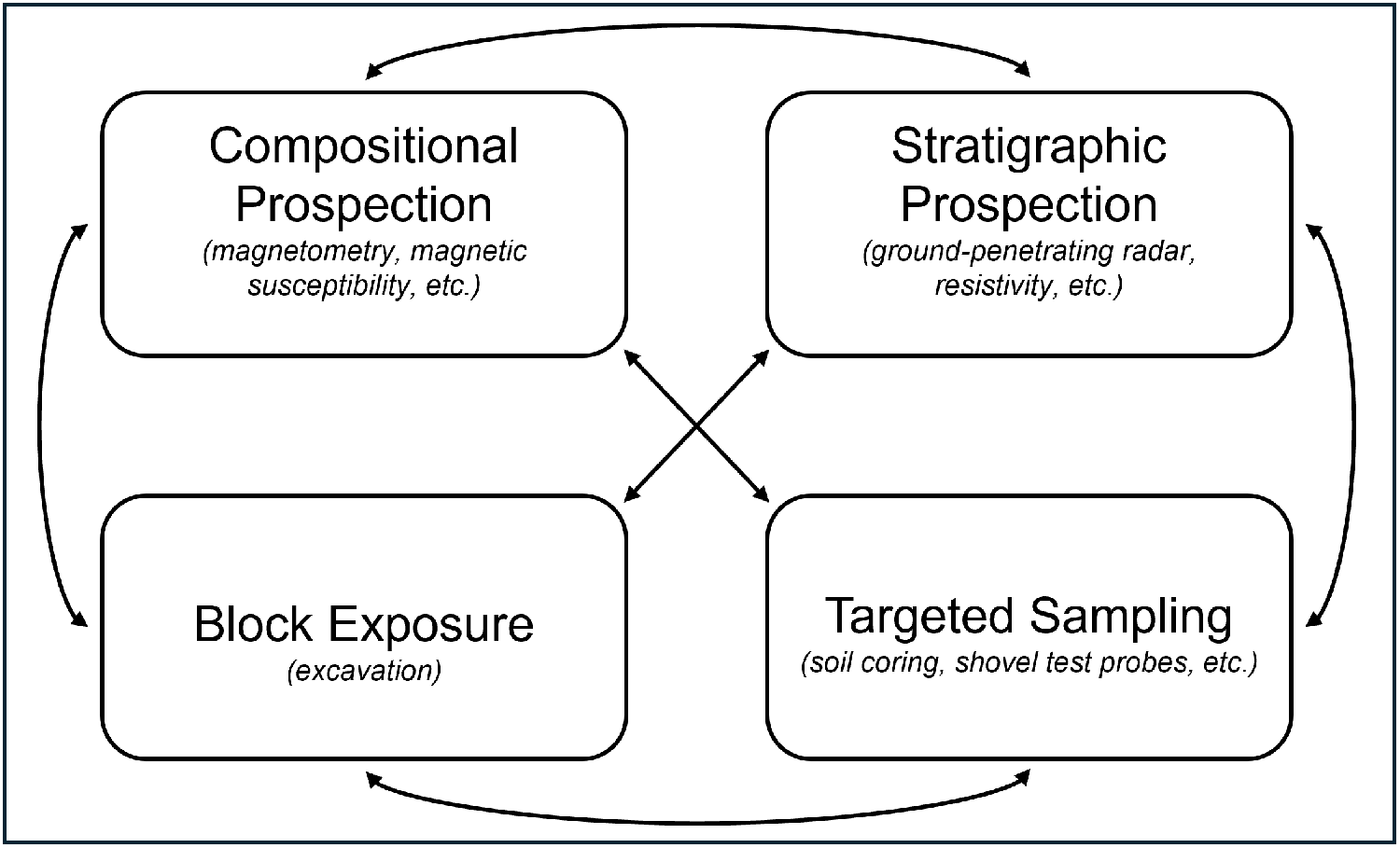
Having demonstrated para-excavation in practice, we can now generalize the framework that defines it. We must first ask ourselves: What types of information does excavation create? When archaeologists excavate, they accomplish several things simultaneously. They observe the composition of buried materials, recording their color, texture, and makeup. They also observe the geometry of buried strata, documenting their shape, depth, and stratigraphic relationships. They expose the buried record directly and unambiguously within a bounded area. And finally, they recover physical samples and artifacts from controlled contexts, generating material for further analysis. Any approach that aspires to replicate excavation’s holistic reach without its destructive footprint must find ways to accomplish all the above interpretive tasks, which requires accomplishing them using a combination of different methods. Para-excavation therefore can be articulated as fulfilling four interpretive roles (Figure 9):
1. Compositional prospection characterizes the makeup of materials beneath the surface. Example methods: magnetic gradiometry, magnetic susceptibility, and electromagnetic induction
2. Stratigraphic prospection establishes the 3D geometry of buried deposits and the relationships between them. Example methods: GPR and electrical resistivity tomography
3. Block exposure provides direct, comprehensive observation of the buried record through targeted excavation, ground-truthing other methods and resolving interpretive ambiguities that noninvasive or minimally invasive techniques cannot
4. Targeted sampling extends subsurface reach across a site rapidly and with minimal disturbance. Example methods: soil coring, shovel test probes, and, in some cases, the surface collection of artifacts
The four interpretive roles of para-excavation. Bidirectional arrows indicate that observations from any role can inform the interpretation of any other one.

These four roles offer a vocabulary for understanding the interpretive leverage available to a given project. For instance, a common strategy in Irish archaeology pairs magnetometry surveys with large-area excavations (Bonsall et al. Reference Bonsall, Gaffney, Armit, Kelly, Roycroft and Stanley2013); this fulfills the compositional prospection and block exposure roles but leaves stratigraphic prospection and targeted sampling unaddressed. Such a combination remains productive, but it constrains the kinds of questions that can be asked and answered. The more para-excavation roles a project can fill, and the more methods deployed within each role, the greater the potential for cross-correlation between datasets, the development of new hypotheses, and iterative refinement of interpretations.
However, no method is rigidly tied to a single role, and many of the most useful techniques do double duty. Ground-penetrating radar is the clearest example; although it is most uniquely positioned as a tool for stratigraphic prospection, radar data also carry compositional information, because the strength and nature of reflections will vary with the physical and chemical characteristics of buried materials (Conyers Reference Conyers2016). Similarly, magnetometry can yield coarse depth estimates, in addition to its primary role as a compositional tool (Menzer Reference Menzer2021). Projects should consider methods as filling roles, rather than belonging to them. The methods listed earlier are illustrative, not exhaustive. Para-excavation is a framework defined by interpretive functions, and many other techniques, including lidar (Vinci et al. Reference Vinci, Vanzani, Fontana and Campana2025), pXRF (Save et al. Reference Save, Kovacik, Demarly‐Cresp, Issenmann, Poirier, Sedlbauer and Teyssonneyre2020), soil geochemical analyses (Campbell et al. Reference Campbell, Beach, Yost and Dunseth2025), thermal imaging (Casana et al. Reference Casana, Wiewel, Cool, Hill, Fisher and Laugier2017), and others not yet developed or widely adopted, can be deployed creatively to fill these roles. Its value lies in helping projects diagnose which interpretive functions their methods accomplish and which remain unaddressed, not in prescribing how those functions should be filled.
From an ethical and practical perspective, para-excavation is minimally invasive. Targeted sampling affects only small portions of the buried record, and much of a para-excavated landscape remains untouched. Sampling methods like coring remove only narrow columns of deposits, leaving most of each feature intact for future investigation. A minimal footprint enables a methodological feature with both practical and ethical weight: para-excavation is replicable. An archaeological landscape can be para-excavated time and time again, with multiple generations of researchers returning to the same place and collecting the same datasets, possibly even sampling the same deposits. Archaeological sites are a nonrenewable resource, and preservation-focused solutions that enable both present study and future research possibilities are not just advantageous but also ethically imperative (Lucas Reference Lucas2001; Roosevelt et al. Reference Roosevelt, Cobb, Moss, Olson and Ünlüsoy2015). Para-excavation, demonstrated in this study and across the literature surveyed earlier, offers a scalable model for the subsurface investigation of stratified sites under the material, logistical, and ethical constraints that increasingly shape archaeological fieldwork. By placing geophysics beside excavation, rather than only before it, this approach enables holistic exploration of the archaeological subsurface and promotes a sustainable future for field-based research.
The relationship between geophysics and archaeological inquiry has been a topic of discussion since the techniques entered disciplinary practice, spanning questions of method, theory, and ethics (Conyers and Leckebusch Reference Conyers and Leckebusch2010; Kvamme Reference Kvamme and Johnson2006b; McKinnon and Haley Reference McKinnon and Haley2017; Sturm and Herrmann Reference Sturm and Herrmann2024). Our work at Ballintober is just one interjection in a long conversation, but it has highlighted the generative benefits of embedding geophysical specialists within multiyear archaeological projects. Many geophysicists intuitively understand the value of sustained collaboration, but few enjoy the opportunity to work alongside excavators for extended periods. At Ballintober, the collaborative debates and discoveries between geophysics and excavation proved transformative, propelling our work in unexpected yet fruitful directions. Our vision of a productive future for archaeology involves further integration of methodological specialties (Pollard and Bray Reference Pollard and Bray2007). Perhaps the GPR antenna will one day join the trowel and the shovel as a fundamental tool in the field archaeologist’s tool kit—not as a specialized instrument requiring outsider expertise but as an integral component of archaeological inquiry itself.
Acknowledgments
First, our thanks to the anonymous reviewers whose comments and suggestions substantially improved the article. We wish to acknowledge our other Castles in Communities codirectors Siobhan Boyd, Ana Lucía González, and Kathryn Maurer; project supervisors and contributors Amber Anderson, Maureen Carpenter, Larry Conyers, Brian Kranzler, and Sean McConnell; and the many hundreds of students and staff on the project who have contributed to our work over the past decade. We would like to recognize the O’Conor Nash family of Clonalis House, the Ballintubber Tidy Towns Committee, and the wider Ballintober community for their support. We are grateful for site access from Alan, Betty, Magella, and Pat Garvey and from Patricia Towey. Thanks to the individuals and institutions that have loaned us the survey equipment used for this project: Joe Fenwick at National University of Ireland Galway, Heather Gimson of Earthsound Geophysics, Wade Campbell of Boston University, Foothill College, Las Positas College, and the Archaeological Diving Company. We would like to additionally express our gratitude to Hugh Carey and his team at Ireland’s National Monuments Service; excavations were permitted under license 15E0232 (Niall Brady, license holder). Finally, thanks to Camille E. Rullán Buxó for translation of the abstract into Spanish.
Funding Statement
This research was funded by tuition from the students of Castles in Communities. The reported radiocarbon dates were funded by Harvard University’s Teschmacher Fund.
Data Availability Statement
Digital copies of excavation and geophysical reports are available at the project’s website (https://castlesincommunities.com) or by request from Ireland’s National Monuments Service (nmarchive@housing.gov.ie). The data presented here, including full geophysical datasets, are also available by request from the corresponding author (andrewbair@g.harvard.edu).
Competing Interests
The authors declare none.



 Open access

