INTRODUCTION
So-called ‘bottom-up’ approaches to environmental planning and management have been widely advocated as being more functional and democratic than ‘top-down’ approaches (Kellert et al. Reference Kellert, Mehta, Ebbin and Lichtenfeld2000; Li, Reference Li2001; Carr Reference Carr2002). This discourse is closely associated with a global movement concerned with the decentralization of governance and the transfer of state assets or powers to subordinate (local or regional) decision-making bodies, including non-governmental organizations (Agrawal & Gibson Reference Agrawal and Gibson1999; Ribot Reference Ribot1999). ‘Bottom-up’ environmental management is said to be more sensitive to local circumstances, involve direct participation of local actors and deploy local knowledge in management (Scott Reference Scott1998; Leach et al. Reference Leach, Mearns and Scoones1999).
While these approaches to environmental management have been heavily promoted in developing regions (e.g. sub-Saharan Africa, see Ribot (Reference Ribot2002), Indonesia and Thailand), the enthusiasm with which Australian jurisdictions have embraced the approach (see Lane et al. Reference Lane, Cheers and Morrison2005 for a review) is probably unique among developed western nations.
Local-centric approaches to environmental management have emerged to combat the so-called ‘rational-comprehensive’ model of planning and management dominated in the post-war years (Sandercock Reference Sandercock1998). In environmental planning, the emphasis has long been on rigorous scientific assessment for developing management strategies, because objective measures were assumed to lead to better understanding of highly complex and dynamic environments. Scott (Reference Scott1998) attacked this approach in great empirical detail and with real theoretical power by reviewing some of the grand plans of modern history, including German scientific forestry, collectivization in Russia, the Great Leap Forward in China and agricultural ‘modernization’ in the tropics. In Scott's (1998) analysis, the great failure of rationalism is not the use or application of technical knowledge, but its failure to acknowledge or incorporate other forms of knowledge. His research shows how these ambitious plans either failed or had catastrophic consequences for local peoples because the scientific tools that planners and designers deployed did not adequately deal with the nuanced complexities of localities (Scott Reference Scott1998). Hence, while technical or scientific knowledge helps us understand some features of environment, it might also obscure or fail to recognize other aspects (Lane et al. Reference Lane, Ross, Rickson and Dale2003). Overcoming such limitations by incorporating local knowledge systems has become an agenda for improving environmental management around the world (Berkes & Folke Reference Berkes and Folke1998; Robertson & McGee Reference Robertson and McGee2003).
The problem of how both local and technical systems of knowledge may be effectively used in environmental decision-making has bedevilled recent and contemporary approaches to management. Complaints about the marginalization of local knowledge are common (see for example Howitt Reference Howitt2001). Others highlight the deep divide between a managerial language which emphasizes scientific expertise and a ‘communitarian alternative’ primarily focused on direct community action and influence (Williams & Matheny Reference Williams and Matheny1995, p. 69).
Recently local environmental management and restoration has been vigorously pursued in Australia through institutional and administrative decentralization (see Lane et al. Reference Lane, McDonald and Morrison2004). For example, in phase 1 of the Australian Federal Government's Natural Heritage Trust (NHT) programme, over 40% of c. A$ 1.5 billion in grants was allocated to (often recently formed) local community organizations, compared with 36% directed to State Government agencies (Hassall & Associates Pty Ltd 2005). In this and other exercises, Australian researchers and policymakers seem persuaded that environmental management at the local or regional scale ensures high levels of public participation, the use of local knowledge in management and the ‘customization’ of management strategies to the particularities of local context. In this context, the proponents of localization and regionalization have made some florid rhetorical claims. One prominent group have asserted that Australia needs to give ‘power back to our communities’ (The Wentworth Group 2002, p. 3), while others have plaintively cried ‘let the locals lead’ (Head Reference Head2004, p. 30). The Federal ministers responsible argued that implementation of the NHT programme was ‘putting the dollars . . . with local communities who know best’ (Hill & Anderson Reference Hill and Anderson1998, p. 3). Reflecting what appears to be a widespread consensus on the benefits of localization, there has been very little debate in Australia as both State and Federal jurisdictions have restructured their environmental management regimes to provide for direct community engagement.
Debate on the benefits of localization has been more widespread elsewhere, most notably in the European Union (Jordan Reference Jordan2000). The principle of subsidiarity in governance is that decisions about how resources should be allocated, used and managed are best made at the level of government that most closely represents the people affected by those decisions (Ribot Reference Ribot2002). While this seems straightforward, two problems emerge. Since ecological change is patchy and occurs across scales there is no single right scale for management (Pritchard & Sanderson Reference Pritchard, Sanderson, Gunderson and Holling2002, p. 150), and the scale at which governmental functions are performed is a politically contested issue (Jordan Reference Jordan2000).
The increased emphasis on local knowledge as a basis for environmental decision making has not gone unchallenged in Australia. By nature of their decentralized nature, local-centric programmes such as the NHT are difficult to assess adequately (Hassall & Associates Pty Ltd 2005). Nevertheless, Australian critics have variously decried these efforts for failing to deliver on their ecological promises, for marginalizing science in the development of management strategy and for disenfranchising disadvantaged actors (for example Possingham Reference Possingham2000; Lane et al. Reference Lane, McDonald and Morrison2004; Lane Reference Lane2005; Lowe Reference Lowe and Manne2004). Internationally, Kellert et al. (Reference Kellert, Mehta, Ebbin and Lichtenfeld2000) found almost no evidence to support the contention that decentralized environmental governance improves the use of local and modern ecological knowledge.
We outline circumstances in which privileging local knowledge can result in poor environmental management decisions by examining the environmental history of Lake Ainsworth. The local community's understanding of the Lake's history and its preferred management objective are assessed in terms of their internal consistency and conformity with other forms of knowledge (diatom history, historical maps and aerial photographs).
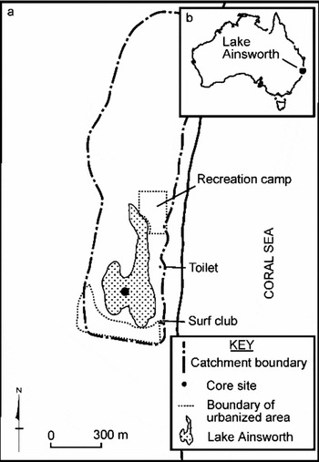
Lake Ainsworth is a coastal lake situated behind sand dunes deposited since the Holocene marine transgression in a geological setting that may be more recent than previously thought (see Goodwin et al. Reference Goodwin, Stables and Olley2006). It is one of few lakes on the New South Wales coast thought not to experience regular oceanic connection (Timms Reference Timms1982; Healthy Rivers Commission of New South Wales 2002), which is unusual given the site's relative proximity to the ocean (Fig. 1). Lake Ainsworth lies immediately north of the township of Lennox Head (population c. 4000).
Lake Ainsworth and catchment: (a) sediment coring site and (b) Lake location.

The Lake's waters are fresh, acidic and nutrient rich (van Senden et al. Reference van Senden, Howells and Anderson1996). Located on its shores are a caravan park and a recreation facility (Fig. 1). Lake Ainsworth was designated for public recreation in 1893 and is a popular leisure site for visitors and locals, with active recreation including year-round swimming and boating (van Senden et al. Reference van Senden, Howells and Anderson1996).
METHODS
In order to determine the long-term water quality history of Lake Ainsworth, the diatom record of a sediment core from the Lake's centre was examined. Diatoms are robust indicators of past and present water quality, particularly salinity (Gasse et al. Reference Gasse, Barker, Gell, Fritz and Chalie1997; Gell Reference Gell1997), pH (Battarbee et al. Reference Battarbee, Charles, Dixit, Renberg, Stoermer and Smol1999; Tibby et al. Reference Tibby, Reid, Fluin, Hart and Kershaw2003) and nutrient status (Kelly Reference Kelly1998; Hall & Smol Reference Hall, Smol, Stoermer and Smol1999; Tibby Reference Tibby2004). The 55-cm long sediment core was extracted in 2003 using a hand-operated soft-sediment corer and vertically sectioned into 1-cm increments in the field. To provide estimates of sediment age, 210Pb was measured by alpha spectrometry (Canberra 2404 Gas Proportional Alpha-Beta Counter) on 1-cm slices sampled every 4 cm, with an additional sample from 2–3 cm. Unsupported 210Pb was inferred from the total 210Pb minus the activity of supported 210Pb, derived from decay of 226Ra. Total 210Pb was measured indirectly via the grand daughter 210Po. Age-depth estimates were calculated using both constant rate of supply (CRS) and constant initial concentration (CIC) modelling of the excess 210Pb data (Appleby Reference Appleby, Last and Smol2001).137Cs was measured using gamma spectrometry (Canberra Compton suppression gamma spectrometry detector system) on 2-cm intervals subsequent to 210Pb analysis to assess the veracity of the derived age-depth relationship. This focused on depths in the lower part of the record (top of sample slice depths: 2.5, 7, 11, 19, 31, 38, 43, 47 and 51 cm).
Diatoms were prepared from the sediments using a modification of the methods of Battarbee et al. (Reference Battarbee, Jones, Flower, Cameron, Bennion, Carvalho, Juggins, Smol, Birks and Last2001). Diatoms were mounted on slides using Naphrax mounting medium and 300 diatom valves were counted per sample on a Nikon E-600 microscope under Nomarski differential interference contrast at 1000 × magnification.
An assessment of community understanding of Lake Ainsworth's history was, for the most part, based on individual telephone responses to a call issued by the local government authority, Ballina Shire Council, in the local media for members of the community to comment on the unexpected finding of a saline phase in the Lake's European history. In this case ‘community’ includes people who no longer reside in the area, but is dominated by people who live within one hour's automobile journey of Lake Ainsworth. Employees at the Council recorded the recollections of individuals who reported that the Lake had been fresh, saline or open to the ocean and the timing of these ‘events’. A number of these people were then contacted by telephone for further information or clarification, as were specific individuals known to have a lengthy connection with the Lake. Although the nature and level of details about the Lake varied, all respondents provided comment on whether they had any knowledge of Lake Ainsworth being either saline or open to the ocean. Each respondent also identified periods of time in which they believed the Lake was fresh or saline (or connected to the ocean). Recollections of older family members were also included. Where people indicated that the Lake had been fresh their entire living memory, this was assumed to be the time since they were ten years old. The approach used was biased towards reporting of saline phases, given that recollections of such events were specifically sought by the local media (Anon. 2004; Stigwood Reference Stigwood2004) and because this notion contrasted with previously held beliefs about Lake Ainsworth (Timms Reference Timms1982; van Senden et al. Reference van Senden, Howells and Anderson1996).
RESULTS
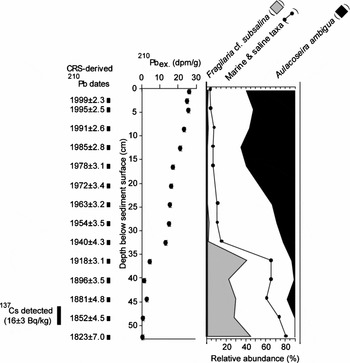
At ≥ 35 cm, diatom assemblages were dominated by saline taxa (Fig. 2). Sediments from 35–36 cm depth were estimated by CRS modelling of 210Pb data to be 85 years old (c. 1920 ad), and those from 32–33 cm depth 63 years old (c. 1940 ad). CIC modelling of the 210Pb data indcated lower ages (for example 1960 at 35–36 cm) inconsistent with the recent history of the Lake. By contrast, 137Cs (detectable in Australian lake sediments from 1959) was present at 47 cm and suggests much younger sediment than the 210Pb-based estimates. However, 137Cs may be mobile in highly organic dune lake sediments such as those in Lake Ainsworth (Torgensen & Longmore Reference Torgensen and Longmore1984). The 137Cs data are suggestive of a late 1950s oceanic connection, yet a combination of parish map and aerial photographic evidence (Figs 3 and 4) does not support this concept. Hence, it appears that the CRS modelled210Pb age-depth profile provides the best estimate of sediment ages.
Chronology, excess 210Pb and summary diatom results for the Lake Ainsworth core indicating the total proportion of marine and saline diatoms in the core. Also shown are the relative abundances of the two most numerous marine or saline (Fragilaria cf. subsalina) and freshwater (Aulacoseira ambigua) taxa. 137Cs was not detectable in a sample from 50–52 cm (3 ± 2 Bq kg−1).

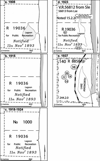
Transcribed details from parish of Newrybar maps of the Lake Ainsworth area. (a) 1908, (b) 1915, (c) 1918–1924 (the age of the map is imprecise, but dates on the full map bracket it between 1918 and 1924), (d) 1923 and (e) 1937. With the exception of north arrows and scale bars, all clear details and legible text were transcribed, with text styles chosen to approximate those on the original maps.

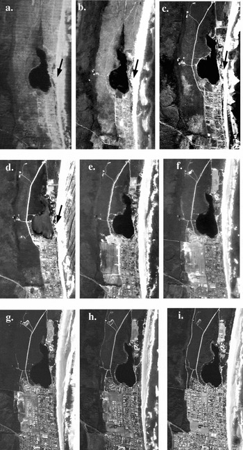
Aerial photographs of Lake Ainsworth and surrounds. (a) 1947, (b) 1958, (c) 1967, (d) 1972, (e) 1979, (f) 1987, (g) 1991, (h) 1997 and (i) 2004. The arrows in (a)–(d) indicate the position of an unvegetated section of the dune separating Lake Ainsworth from the ocean.

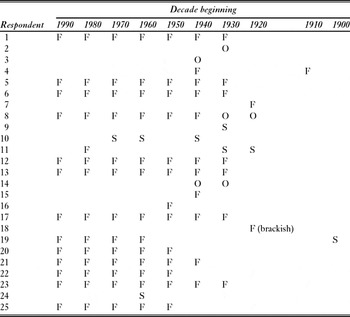
Among the 25 respondents there was considerable contrast in recollections of Lake Ainsworth's water quality history. Fifteen definitively reported that Lake Ainsworth had been freshwater in all their experience (Table 1), which for the majority of respondents, was their entire living memory, a period up to 75 years. These accounts generally originated from people who lived in close proximity to the Lake and a number who had swum in Lake Ainsworth from a young age. Included in these recollections were definitive accounts of the Lake being fresh, including those from people who remembered washing off salt water from the ocean by swimming in the Lake (respondent 16).
Community recollections of the state of Lake Ainsworth. F = fresh, S = saline, C = ‘closed’ oceanic connection and O = ‘open’ oceanic connection.

By contrast, four respondents reported strong recollections of periods of time when the Lake was not fresh. The most specific account was from a woman (respondent 11) whose mother expressed surprise upon finding the Lake fresh ‘[a]bout 25 years ago’ since she had recalled the need to carry fresh water on fishing trips between 1927 and 1934 ‘because the Lake was salt’. Respondent 9 fished in the Lake during the 1930s and recalled it being salty and the presence of an oceanic connection near the present day toilet block (Fig. 1). Another four people indicated they could recall times when the Lake was connected to the ocean. Three of these respondents nominated a specific geographic position for the connection, with two (respondents 8 and 24) suggesting that the connection was in the northern section of Lake (near the present recreation camp or toilet block, Fig. 1). This connection was said to have occurred between the two World Wars (respondent 8) or in 1968 (respondent 24). A further respondent (14) suggested that the connection had been near the present surf club (in the southern section of lake) during the 1930s and 1940s.
The diatom evidence for an oceanic connection that ended in the mid to late 1930s (indicated by CRS model 210Pb dating) can be compared with the recollections of 13 respondents (Table 1). The majority suggested the Lake was fresh during the 1930s. However, two (respondents 9 and 11) indicated that the Lake may have been saline, while another (respondent 14) reported an oceanic connection during this time.
One local community member highlighted the existence of parish maps dating to 1908. These maps show Lake Ainsworth with various degrees of connection to the sea (Figs 3a–e). The 1908 map (Fig. 3a) clearly shows a connection between Lake Ainsworth and the ocean that, presumably, would have resulted in mixing of lake and ocean water intrusion. The 1915 map (Fig. 3b) is insufficiently detailed to assess any oceanic connection, while there is some suggestion of a recent connection in the 1918–1924 map (Fig. 3c). However, it appears that the Lake was closed to the ocean in 1923 (Fig. 3d). In the 1937 map, the easternmost margin of the Lake was c. 25 m from the beach, perhaps indicating a recent closure of the Lake to the ocean (Fig. 3e).
Aerial photographs document significant changes in land use from 1947 to 2004 (Fig. 4), however none indicates an oceanic connection.
DISCUSSION
Parish maps indicate the Lake was definitely connected to the ocean in 1908 and may have been connected in a period bounded by 1918–1924 and c. 1937. The earliest of these dates was beyond the living memory of any respondents and does not contradict any accounts. However, respondent 19 related an account consistent with the 1908 map provided by a relative of Thomas Ainsworth who owned land immediately adjacent to the Lake. In 1910, Ainsworth noted that local landholders would be pleased because there was ‘not much chance of the sea breaking through again’ which meant that the Lake's waters were suitable for stock consumption, following recent isolation from the sea.
By contrast to the diatom-based evidence for a saline phase in the Lake's history, Timms (Reference Timms1982) indicated the lake was ‘permanently’ freshwater, largely on the basis of a characteristic freshwater fauna. This concept was repeated in a process study (van Senden et al. Reference van Senden, Howells and Anderson1996) that formed the basis of the Lake's current management plan. Included in the plan is a priority ‘to assist the survival of Lake Ainsworth as a freshwater lake’ (Anon. 2002), through dune stabilization works.
Interestingly, two respondents suggested later connections between the Lake and the ocean, with respondent 10 suggesting this occurred during the 1960s and 1970s and respondent 24 suggesting this was during the 1960s. The weight of evidence suggests these accounts of later connections (which contrast with 13 other respondents) are unreliable. There is no diatom evidence for a connection during this period, with the dominant diatom during this period being the freshwater planktonic species, Aulacoseira ambigua, while the aerial photographs covering this period provide no evidence of an ocean connection. Indeed, there was relatively little alteration in the morphology of the dune separating the Lake from the ocean in the period 1947–1972 (Fig. 4).
Despite the relatively simple nature of the environmental question raised in this study, it is apparent that community perceptions were contradictory. In contrast to Roberts and Sainty's (2000) experience with the oral history of the Lachlan River (New South Wales, Australia), we found no consensus understanding of Lake Ainsworth's history. In that study, most respondents provided a clear indication that substantial human-induced degradation of the Lachlan River began in the 1960s (Roberts & Sainty Reference Roberts, Sainty and Dovers2000). The more recent nature of this change, which is consistent with the present state of the ecosystem, renders Roberts and Sainty's (2000) oral history an apparently more reliable data source than the local knowledge from Lake Ainsworth.
Salinity change in Lake Ainsworth's European history has been associated with substantial geomorphic modification (Fig. 3), yet many respondents did not identify these changes. It may be that different use strategies affect perceptions of the Lake's salinity. Sheep and cattle will consume water containing ≤ 5 g L−1 salt without reluctance or adverse effects (Australian and New Zealand Environment and Conservation Council & Agriculture and Resource Management Council of Australia and New Zealand 2000). This is well above the point at which saline water becomes unfit for humans to drink and substantially exceeds the point at which people can taste salt in water (< 1 g L−1 total dissolved solids; National Health and Medical Research Council and Natural Resource Management Ministerial Council 2004). Despite this possible explanation, the contrasting perceptions of a relatively simple environmental issue indicate that perceptions of more complex issues may be problematic.
Local environmental knowledge is increasingly emphasized as a valuable guide to environmental management and restoration (Robertson et al. Reference Robertson, Nichols, Horwitz, Bradby and MacKintosh2000; Robertson & McGee Reference Robertson and McGee2003), with some suggesting it should be accorded equal importance to scientific knowledge (Robertson et al. Reference Robertson, Nichols, Horwitz, Bradby and MacKintosh2000). In this study, local perceptions differed starkly from each other and from other information sources. Moreover, it appears that the history of settlement and resource use may, with the passage of time, cause perceptions and understandings to change.
We suggest that the advocacy of local knowledge (Robertson & McGee Reference Robertson and McGee2003), and calls to give substantive credence to ‘environmental narratives’ (Robertson et al. Reference Robertson, Nichols, Horwitz, Bradby and MacKintosh2000), are problematic when such advocacy is made without reference to the complex ways in which human understandings and perceptions are developed and changed. We do not reject the role of local knowledge; instead we caution romanticising local wisdom. Local knowledge should be questioned and tested and, where appropriate, explicitly triangulated with data from other sources in order that an accurate and comprehensive understanding of environmental change can be developed. Such an approach implicitly underlies calls by other workers to integrate local knowledge into environmental decision-making. For example, in Aswani and Hamilton's (Reference Aswani and Hamilton2004) study of Solomon Islanders' perceptions about the ecology of bumphead parrotfish, local ideas not supported by scientific evidence were not incorporated into management plans. The growing literature on the ‘co-production’ of knowledge indicates that complex environmental problems can be addressed by collaborative arrangements in which stakeholders, communities and scientists jointly develop a platform of knowledge (local and scientific) from which management efforts can be developed (Busenberg Reference Busenberg1999; Fischer Reference Fischer2000). Such approaches are more likely to bear fruit than epistemological argumentation.
We do not reject the utility of local knowledge, but rather advocate a greater synthesis of this evidence with that provided by other sources, interpreted by skilled accountable researchers, and open to broad scrutiny.
ACKNOWLEDGEMENTS
This research was supported by Australian Research Council (DP0558887) and Australian Institute of Nuclear Science and Engineering (AINGRA03115) grants to J. Tibby. The Ballina Shire Council, in particular Mr Graham Plumb, provided permission to core Lake Ainsworth and assisted in collating responses of the community to calls for information about the Lake. Liz Hamilton (Department of Lands, New South Wales) provided the aerial photographs. Angus MacGregor, Craig McVeigh and Aline Philibert helped with fieldwork.