Introduction
Lake Bonneville
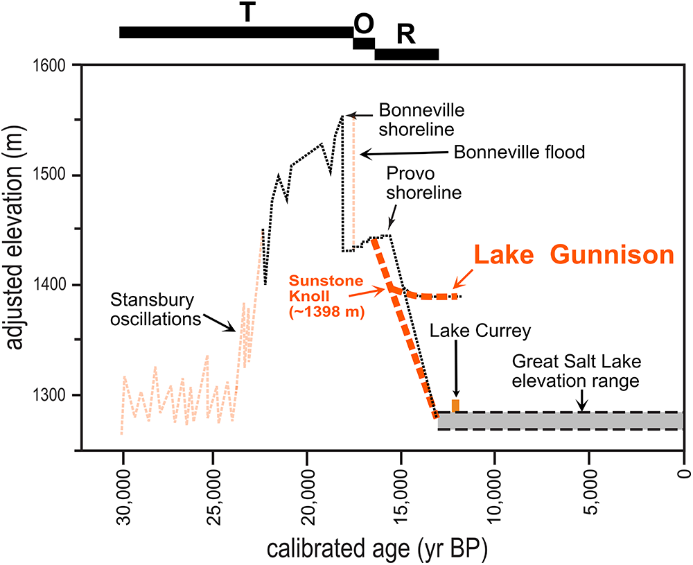
Lake Bonneville (Fig. 1) was a large closed-basin lake that covered much of the eastern Great Basin region in western North America during the Late Pleistocene and was the most recent major lake cycle in the Bonneville basin (Gilbert, Reference Gilbert1890; Oviatt et al., Reference Oviatt, Thompson, Kaufman, Bright and Forester1999). As the large, freshwater endmember of the lacustrine system, which includes Great Salt Lake (Atwood et al., Reference Atwood, Wambeam, Anderson, Oviatt and Shroder2016), Lake Bonneville began to rise from low elevations ∼30 cal ka before falling back to lower elevations by ∼13 cal ka. The changing levels of closed-basin Lake Bonneville have been key features of paleoclimatic reconstructions for the region (Belanger et al., Reference Belanger, Amidon, Laabs, Munroe and Quirk2022), and the general chronology for the lake is well established (Oviatt, Reference Oviatt2015; Oviatt and Pedone, Reference Oviatt and Pedone2024). Although details of the chronology are being refined, such as those details proposed in this paper, the Bonneville lake cycle has been subdivided into three periods (Fig. 2): a transgressive phase, an overflowing phase, and a regressive phase (Currey, Reference Currey1990; Oviatt, Reference Oviatt2015).
Map of Lake Bonneville at its highest level (the Bonneville shoreline). Also shown are Sunstone Knoll, the Old River Bed threshold (ORBT), Bitterweed spit, and the approximate outline of later Lake Gunnison in the orange dashed line; the blue dashed line shows the extension of Lake Gunnison during its early phases (as discussed in this paper) when the ORBT was ∼8 m higher than later in its history. Note that the map outline of Lake Gunnison shown here is different from that shown by Currey (Reference Currey1982) but is the same as that shown by Oviatt et al. (Reference Oviatt, Young and Duke2024).

Hydrograph of Lake Bonneville to put Lake Gunnison into context with the rest of the chronology. The revision to the regressive phase, as reported in this paper, is shown in the dark orange dashed line. Two other revisions to the Lake Bonneville hydrograph (the early transgressive phase [Oviatt and Pedone, Reference Oviatt and Pedone2024] and the age of the Bonneville flood [Oviatt, Reference Oviatt2020]) are shown in lighter orange dashed lines. T, transgressive phase; O, overflowing phase; R, regressive phase.

The transgressive phase of Lake Bonneville began at ∼30 cal ka (Oviatt and Pedone, Reference Oviatt and Pedone2024) and continued until the Bonneville flood, the age of which has been reported as ∼18 cal ka (Oviatt, Reference Oviatt2015), but which is more likely to have occurred at ∼17.5 cal ka or younger (Oviatt, Reference Oviatt2020). Climatic conditions during the transgressive phase, and the probable Late Pleistocene diversion of the upper Bear River into the Bonneville basin, allowed lake levels in the hydrographically closed basin to rise to the highest elevation of any known Quaternary or late Neogene lake (Bright, Reference Bright1963; McCoy, Reference McCoy1987; Bouchard et al., Reference Bouchard, Kaufman, Hochberg and Quade1998; Link et al., Reference Link, Kaufman and Thackray1999; Pederson et al., Reference Pederson, Janecke, Reheis, Kaufman, Oaks, Oviatt and Shroder2016). The lake did not rise continuously, and evidence of multiple transgressive-phase oscillations of lake level that interrupted the long-term trend of the rising lake are present in the geologic record (Scott et al., Reference Scott, McCoy, Shroba and Rubin1983; Oviatt, Reference Oviatt1997; Nelson and Jewell, Reference Nelson and Jewell2015). Contrary to a common misconception reported in the literature, Lake Bonneville did not overflow for a prolonged period before the Bonneville flood during the transgressive phase (Oviatt and Jewell, Reference Oviatt, Jewell, Oviatt and Shroder2016; Oviatt, Reference Oviatt2020). Instead, the lake rose during its transgressive phase until it reached an elevation of ∼1552 m above sea level (asl) in areas not affected by isostatic subsidence and rebound (Currey, Reference Currey1982); the Bonneville flood commenced soon after the lake began to overflow at the Zenda threshold on the alluvial-fan dam in the Red Rock Pass area of present-day Idaho (Gilbert, Reference Gilbert1890; Shroder et al., Reference Shroder, Cornwell, Oviatt, Lowndes, Oviatt and Shroder2016; Oviatt, Reference Oviatt2020).
The overflowing phase of Lake Bonneville began with the commencement of the Bonneville flood and lasted for a period of about 1000 years. This duration is shorter than the previously reported overflowing period of about 3000 years (Oviatt, Reference Oviatt2015). After a drop in lake level of ∼120–125 m during the Bonneville flood (Miller et al., Reference Miller, Oviatt and McGeehin2013), the level of Lake Bonneville stabilized at the elevation of the Red Rock Pass threshold, about 3 km southeast of the Zenda threshold, during the development of the Provo shoreline (Gilbert, Reference Gilbert1890; Miller et al., Reference Miller, Oviatt and McGeehin2013; Oviatt, Reference Oviatt2015).
Lake Bonneville returned to closed-basin conditions during its regressive phase, which began at the end of the overflowing phase, at about 16.5 cal ka (Laabs et al., Reference Laabs, Oviatt and Jewell2019). The regressive phase ended ∼13 cal ka, when Lake Bonneville dropped to about the average elevation of the modern Great Salt Lake (Oviatt, Reference Oviatt2015). During the early regressive phase, Lake Bonneville fell 70 m below the Provo shoreline, until it reached the elevation of the Old River Bed threshold (ORBT) and separated into two lakes, an overflowing freshwater lake in the Sevier basin known as Lake Gunnison, and a closed-basin lake in the Great Salt Lake basin (Gilbert, Reference Gilbert1876, Reference Gilbert1890; Oviatt, Reference Oviatt1988, Reference Oviatt2015; Oviatt et al., Reference Oviatt, Madsen and Schmitt2003, Reference Oviatt, Young and Duke2024; Hart et al., Reference Hart, Quade, Madsen, Kaufman and Oviatt2004; Bradbury et al., Reference Bradbury, Jewell, Fernandez, Lerback, DeGraffenried and Petersen2021; Palacios-Fest et al., Reference Palacios-Fest, Duke, Young, Kirk and Oviatt2021).
Sunstone knoll
Sunstone Knoll is composed of basalt, and is an eroded cinder cone of Neogene age (Johnson and Smith, Reference Johnson, Smith, Carney, Tabet and Johnson2010). It is located in the Sevier basin at 39.146°N, 112.716°W, about 25 km southwest of the town of Delta, UT (Fig. 1). The knoll rises ∼20 m above the desert floor, has an ovate plan-view shape, and is oriented in a north-south direction (Fig. 3). A gravel spit extends for about 200 m toward the east from the southern end of Sunstone Knoll, and although much of the gravel has been excavated from the spit, likely for road construction of the nearby highway or railroad, the general form and elongate shape of the Sunstone Knoll spit can be discerned.
Large-scale maps (A and B) and topographic profile (C) of Sunstone Knoll. Contour interval in B is 0.2 m. Constructed using data from drone flights and satellite images.

The crest of the Sunstone Knoll spit has an elevation of ∼1398 m asl, which is ∼8 m higher than the reported ∼1390 m asl elevation of Lake Gunnison in the Sevier basin (Oviatt, Reference Oviatt1988). A spit at the northeast end of Sevier Lake, about 10 km long and located ∼20 km west of Sunstone Knoll (39.115°N, 112.937°W), is informally named the “Bitterweed spit” (Fig. 1). This spit has been interpreted as having formed during the middle to later phases of Lake Gunnison and has a crestal elevation of ∼1390 m (Oviatt, Reference Oviatt1988). Oviatt (Reference Oviatt1988) hypothesized that coarse sediment deposition at the Bitterweed spit took place during a period when lake level was relatively stable, probably due to overflow of Lake Gunnison via the Old River Bed (ORB) valley. Evidence consistent with this hypothesis has been found to the northwest on Dugway Proving Ground (Oviatt et al., Reference Oviatt, Madsen and Schmitt2003, Reference Oviatt, Young and Duke2024; Madsen et al., Reference Madsen, Oviatt, Young, Page, Madsen, Schmitt and Page2015), where the 87Sr/86Sr ratios of mollusks collected from the ORB inland delta suggest the primary source of water to the delta was initially Lake Gunnison overflow and later groundwater that flowed northward from the Sevier basin during the Pleistocene–Holocene transition (Rhode and Louderback, Reference Rhode, Louderback, Madsen, Schmitt and Page2015; Bradbury et al., Reference Bradbury, Jewell, Fernandez, Lerback, DeGraffenried and Petersen2021; Palacios-Fest et al., Reference Palacios-Fest, Duke, Young, Kirk and Oviatt2021).
Hypothesis
The ∼1398 m asl elevation of the Sunstone Knoll spit being ∼8 m higher than the accepted elevation of Lake Gunnison (∼1390 m asl) is curious. Observations at Sunstone Knoll of the spit architecture and geomorphology (i.e., hints of foreset bedding produced by spit progradation exposed in hand-dug pits and a reconstructed nearly uniform spit-crest elevation) suggest that the spit formed while the lake surface elevation was constant. These observations combined with the radiocarbon and optically stimulated luminescence (OSL) ages at Sunstone Knoll suggest a hypothesis that spit formation occurred early under conditions similar to those that led to the development of the much larger Bitterweed spit, but ∼8 m higher in elevation.
Strontium isotopes (87Sr/86Sr) have been used in the Bonneville basin to help determine the source of water that fed ancient and modern spring, lake, and fluvial systems (Quade, Reference Quade and Madsen2000; Hart et al., Reference Hart, Quade, Madsen, Kaufman and Oviatt2004; Pedone and Oviatt, Reference Pedone, Oviatt, Oviatt and Shroder2016; Lerback et al., Reference Lerback, Hynek, Bowen, Bradbury, Solomon and Fernandez2019; Bradbury et al., Reference Bradbury, Jewell, Fernandez, Lerback, DeGraffenried and Petersen2021; Palacios-Fest et al., Reference Palacios-Fest, Duke, Young, Kirk and Oviatt2021). The 87Sr/86Sr ratios of Anodonta shells that would have been living during sediment deposition at the Sunstone Knoll spit were measured in this study, allowing for the comparison of those ratios to the 87Sr/86Sr ratios measured for Lake Gunnison shells reported in the literature (Quade, Reference Quade and Madsen2000; Hart et al., Reference Hart, Quade, Madsen, Kaufman and Oviatt2004; Pedone and Oviatt, Reference Pedone, Oviatt, Oviatt and Shroder2016). If the 87Sr/86Sr ratios were a better match with those reported for the Provo level of Lake Bonneville (Hart et al., Reference Hart, Quade, Madsen, Kaufman and Oviatt2004; Pedone and Oviatt, Reference Pedone, Oviatt, Oviatt and Shroder2016), the Sunstone Knoll spit would not be interpreted as having formed in Lake Gunnison, and a different formation scenario would have to be proposed.
Before the work described in this paper, some information had suggested that the history of Lake Gunnison involved a change in lake level through time, although this was not stated explicitly. An example of information that could have led to an explicit expression of that conclusion was a radiocarbon date reported by Isgreen (Reference Isgreen1986) for Anodonta shells collected at the Sunstone Knoll spit. At 12.5 ± 0.13 14C ka, or ∼14.5 cal ka (Table 1), this age is older than other ages reported for Lake Gunnison when it had an elevation of ∼1390 m asl, which range between about 13.3 and 11.6 cal ka (Currey, Reference Currey1980; Oviatt, Reference Oviatt1988; Table 2). The radiocarbon date reported almost 40 years ago by Isgreen (Reference Isgreen1986), although important in the chronology of the regression of Lake Bonneville, was not relied on heavily in previous assessments of the age of the beginning of the regressive phase, such as that by Godsey et al. (Reference Godsey, Oviatt, Miller and Chan2011).
Sunstone Knoll radiocarbon dates.a

a All samples were collected from the sand and gravel of the Sunstone Knoll spit, within about 1 vertical meter; elevation about 1397 m. See footnote a in Table 2 for an explanation as to why no adjustment for isostatic rebound is appropriate.
b Ages in 14C ka BP. All dates were for samples of Anodonta sp. shells collected from spit gravel at 39.145493°N, 112.712654°W, datum NAD83.
c Ages in cal ka. Calibrated using Calib8.2 and the data set IntCal20 (http://calib.org/calib/calib.html); Reimer et al. (Reference Reimer, Austin, Bard, Bayliss, Blackwell, Bronk Ramsey and Butzin2020); Stuiver and Reimer (Reference Stuiver and Reimer1993).
Radiocarbon ages for later Lake Gunnison.a

a No isostatic adjustment is applied to the elevations of any of these samples, because as far as can be determined, all isostatic rebound had been completed in the Sevier basin by Lake Gunnison time. This conclusion is based on the observation that the Gunnison shoreline has the same elevation (1390 m) at all points surrounding Sevier Lake (Currey, Reference Currey1982; personal observations by C.G. Oviatt, 1980s to the present).
b All ages in thousands of years, either 14C yr or cal yr BP (ka); radiocarbon ages calibrated using Calib8.2 and the data set IntCal20 (Stuiver and Reimer, Reference Stuiver and Reimer1993; Reimer et al., Reference Reimer, Austin, Bard, Bayliss, Blackwell, Bronk Ramsey and Butzin2020). med prob., median probability.
c Datum NAD83.
The Isgreen (Reference Isgreen1986) date was generated using conventional 14C lab procedures, not by accelerator mass spectrometry (AMS) methods, and had a large 1σ analytical error. We use the date in this paper because its calibrated-age 2σ range overlaps with five AMS 14C ages, three of which are newly obtained, and the OSL date; it falls in the younger end of those age ranges.
The observation that the Sunstone Knoll spit was deposited in an early and higher iteration of Lake Gunnison affects the chronology of the regressive phase of Lake Bonneville. Prior work on dating the regressive phase suggested that it began at about 15 cal ka (Godsey et al., Reference Godsey, Oviatt, Miller and Chan2011; Oviatt, Reference Oviatt2015). However, based on information described in this paper, it can reasonably be interpreted that Lake Bonneville had regressed to the elevation of Sunstone Knoll earlier than 15 cal ka.
Materials and methods
Field methods
Field examinations of the spit and surrounding geomorphology and Quaternary stratigraphy were conducted on many expeditions to Sunstone Knoll between the 1980s and 2022. Detailed maps of Sunstone Knoll were constructed using data from both drone and satellite imagery.
Anodonta shells were collected from spit sediment for radiocarbon and strontium-isotope analyses. Collected shells were placed into labeled sample containers for transport to the Accelerator Mass Spectrometry (AMS) Laboratory at the University of Arizona and the University of Utah Strontium Isotopes Laboratory.
Anodonta sp., freshwater mussels of the family Unionidae, are found throughout the Bonneville basin and are widespread in the fossil record of the Great Basin (Mock et al., Reference Mock, Brim‐Box, Miller, Downing and Hoeh2004). Freshwater mussels are also endobenthic, able to use a muscular foot to burrow into sediment (Allen and Vaughn, Reference Allen and Vaughn2009). This makes them ideal for studying the chronology of the Sunstone Knoll spit, as the mussels would have likely burrowed into the spit sediment when they were alive.
The Anodonta shells we collected at Sunstone Knoll are whole or entire. Imbedded in the spit sand and gravel, many left and right valves of Anodonta are found articulated and retain the “pearly luster” typical of aragonite. We interpret the Anodonta shells we sampled as not having been reworked from some older deposit. Although it is theoretically possible that fragments of Anodonta shells could have been reworked from pre-Bonneville or early Bonneville deltaic deposits in the Sunstone Knoll area into the spit sand and gravel, we have not observed evidence that that happened, and we did not sample fragments. In the Sevier basin, Anodonta shells are found in shallow-lacustrine deposits and alluvium of perennial streams. At Sunstone Knoll, the only sediment we know of that had an appropriate depositional environment for Anodonta sp. is the spit sand and gravel (some alluvial deposits in the Sunstone Knoll area, which are inset below the elevation of the spit and are younger, might have had an appropriate depositional environment, but they are not considered here). Anodonta shells are also ideal for 87Sr/86Sr analysis, as postdepositional modifications of shell chemistry do not appear to affect original Sr content for freshwater mollusks (Rosenthal and Katz, Reference Rosenthal and Katz1989).
OSL sample collection at Sunstone Knoll was part of a larger study investigating the timing of paleohydrologic fluctuations in the Sevier basin and the northern end of the ORB paleo-valley at Dugway Proving Ground, Great Salt Lake basin (Spencer et al., Reference Spencer, Oviatt, Pathak and Fan2015; Fig. 1). Sample SK10-052210-01 (hereafter referred to as SK-10) was collected from freshly exposed basaltic sands in a hand-dug pit in the Sunstone Knoll spit (Table 3, Supplementary Fig. S1; see also Supplementary Figs. S2 and S3). The pit was excavated to the depth of the Bonneville marl described by Godsey et al. (Reference Godsey, Oviatt, Miller and Chan2011). The chosen sampling position was ∼30 cm above the marl and ∼90 cm below the present surface (Supplementary Fig. S1), located in the middle of the deposit of basaltic sand, gravel, and scattered Anodonta shells. The sample was collected by hammering a metal tube (∼4 cm in diameter by ∼15 cm in length) into the freshly exposed sediment in the wall of the pit, such that a sample not exposed to sunlight could be obtained for analysis. An additional sediment sample was taken for environmental radioactivity assessment.
Optically stimulated luminescence (OSL) sample field location details.

a Degrees east longitude following convention for cosmogenic dose-rate calculation For cosmogenic dose-rate calculation, the longitude value used is -112.71263 (degrees east; Prescott and Hutton, Reference Prescott and Hutton1994; Table 4A). Datum NAD83.
b The uppermost ∼30 cm aeolian sand/silt cap (Supplementary Fig. S1) was most likely deposited a significant time after the Sunstone Knoll spit, thus reducing the effective overburden during the majority of the burial period of the sample to ∼60 cm. This sample was collected from the sand and gravel of the Sunstone Knoll spit, with an elevation of about 1397 m. See footnote a in Table 2 for an explanation as to why no adjustment for isostatic rebound is appropriate.
Radiocarbon dating
Radiocarbon ages for Anodonta shells collected at Sunstone Knoll were obtained for three samples of Anodonta sp. shells (Table 1). The shells were sent to the AMS Laboratory at the University of Arizona, where they were analyzed using the laboratory’s standard methodologies and procedures. The outer layers of shells were dissolved first, and the interiors of the shells were dated (Cheng, L., University of Arizona, personal communication, 2025). Calendar (calibrated) median-probability ages and 2σ age ranges (Table 1) were determined using the Calib 8.2 program and IntCal20 atmospheric dataset (Stuiver and Reimer, Reference Stuiver and Reimer1993; Reimer et al., Reference Reimer, Austin, Bard, Bayliss, Blackwell, Bronk Ramsey and Butzin2020). These three dates when combined with three radiocarbon dates previously obtained from the spit at Sunstone Knoll yield a total of six radiocarbon dates from the site.
We recognize that by partly relying on radiocarbon ages of Anodonta shells (a bivalve mollusk), we leave ourselves open to the question of whether this conflicts with other interpretations where radiocarbon ages for mollusk shells have been reinterpreted. Specifically, Oviatt and Pedone (Reference Oviatt and Pedone2024) decided that radiocarbon ages for samples of mollusks (gastropods and one sample of bivalves of a different genus) were more likely to be maximum-limiting dates rather than closely limiting dates (the traditional interpretation) for the early transgressive phase of Lake Bonneville. This decision was made in the context of radiocarbon and uranium-thorium dates of microbialites (tufa) that were similar in age to the mollusk ages but at much lower elevations (in addition, although not pertinent in the case of Sunstone Knoll, Oviatt and Pedone [Reference Oviatt and Pedone2024] also considered wood and charcoal Ages that conflicted with the radiocarbon and uranium-thorium ages of microbialites to be maximum-limiting dates). Although not assessed for individual samples, there are excellent possibilities for why the mollusk ages (reinterpreted by Oviatt and Pedone [Reference Oviatt and Pedone2024]) might have been older than their respective ages of deposition; those possibilities are a radiocarbon reservoir in the water where the mollusks lived or reworking of shells from some older deposit. No evidence of either a radiocarbon reservoir or reworking has been found at Sunstone Knoll, and no alternative information is available for the age of the spit at Sunstone Knoll.
As aquatic organisms, Anodonta bivalves obtain the carbon for their tissues from dissolved CO2 in the water in which they live rather than from the atmosphere. If there happened to be a radiocarbon reservoir in the water (that is, if the 14C content of bicarbonate and carbonate ions in the water was lower than that of the contemporaneous atmosphere, thus making the dissolved carbon old compared with carbon in the contemporaneous atmosphere), the Anodonta shells would appear to be older than the age of sediment and mollusk deposition.
However, no evidence of a radiocarbon reservoir has been found for Lake Gunnison at or near Sunstone Knoll. As far as we know (Oviatt, Reference Oviatt1988, Reference Oviatt1989; Oviatt et al., Reference Oviatt, Habiger and Hay1994), the dominant water in Lake Gunnison was derived from rivers (the Beaver and Sevier Rivers) and did not have a radiocarbon reservoir. In a shallow overflowing lake fed by two major rivers, the groundwater inputs would have been highly variable (groundwater might contain dissolved CO2 out of equilibrium with the contemporaneous atmosphere), probably with local areas in the lake of intense groundwater input and other areas with no groundwater input. The chances of groundwater dominating the water budget at Sunstone Knoll where no independent evidence of groundwater discharge has been found seem slim (we acknowledge that it is possible, but speculative, because no evidence has been found, that diffuse groundwater discharge entered Lake Gunnison through fine-grained sediments on the lake floor).
If the radiocarbon ages of Anodonta shells from Sunstone Knoll were influenced by a radiocarbon reservoir, or if the shells had been reworked from some older deposit, the radiocarbon age range would be older than the OSL age from the same deposit. But this is not what we observe. The age range of our one OSL date overlaps with the age range of the radiocarbon dates from the same deposit; statistically the mean ages are identical. Clearly it would be good to have additional information as the basis for making a final conclusion, and eventually this may happen, but the interpretations presented in this paper are based on the data at hand.
OSL dating
Routine OSL dating methods (Preusser et al., Reference Preusser, Degering, Fuchs, Hilgers, Kadereit, Klasen, Krbetschek, Richter and Spencer2008; Rhodes, Reference Rhodes2011; Mahan et al., Reference Mahan, Rittenour, Nelson, Ataee, Brown, DeWitt and Durcan2023) were used to analyze sample SK-10. OSL measurements were conducted at the Kansas State University Luminescence Research and Dating Laboratory, and high-resolution gamma-spectrometry measurements were conducted at Lucas Newman Science and Technologies Inc., in Stillwater, OK. Separation and OSL measurements of quartz minerals at Kansas State University followed methods similar to those described in Spencer et al. (Reference Spencer, Oviatt, Pathak and Fan2015) and Ashley et al. (Reference Ashley, Ndiema, Spencer, Harris, Kiura, Dibble, Du and Lordan2017). Measurements of 1-mm-diameter aliquots of 175–212 μm quartz were done using a Risø TL/OSL-DA-20 reader (Bøtter-Jensen et al., Reference Bøtter-Jensen, Andersen, Duller and Murray2003). Single-aliquot regenerative-dose (SAR) protocols, dose-distribution analyses, and statistical age models were used to determine final equivalent dose (De). Total dose rate was determined from radioelement data from high-resolution gamma spectrometry, field moisture assessment, and cosmic dose-rate calculations.
Further information about the OSL dating and methodology is provided in the Supplementary Material (Supplementary Figs. S1–S5).
87Sr/86Sr ratio analysis
An aliquot of shell digest containing 200 ng of strontium was apportioned for 87Sr/86Sr analysis using a multi-collector inductively coupled plasma mass spectrometer (MC-ICP-MS) (Neptune, Thermo Scientific, Bremen, Germany) at the University of Utah Strontium Isotopes Laboratory. The strontium of each aliquot was purified using an automated ion chromatography system equipped with a 1 mL column containing SrCa resin (PrepFAST MC, ESI, Omaha, NE, USA). Purified samples were then input into the MC-ICP-MS with a self-aspiration perfluoroalkoxy nebulizer (0.05 mL/min), double-pass quartz spray chamber, sapphire injector, and nickel cones. Standard Rb-Sr cup configuration was utilized as outlined in Bradbury et al. (Reference Bradbury, Jewell, Fernandez, Lerback, DeGraffenried and Petersen2021), and 87Sr/86Sr ratios were corrected for mass bias using an exponential law normalizing to 87Sr/86Sr = 0.1194, with isobaric interferences in 87Sr/86Sr ratios corrected by simultaneous monitoring of 85Rb and 83Kr and using the corresponding invariant ratios 87Rb/85Rb = 0.385706 and 86Kr/83Kr = 1.502522 (Steiger and Jager, Reference Steiger and Jager1977).
Certified reference material (CRM) 987 (SrCO3, National Institute of Standards and Technology) was used to check data quality. To do this, a solution of CRM 987 in 6 M HNO3 was purified for strontium in the same manner as shell digest aliquots. This purified standard was then run as a sample during each run. A solution of CRM 987 in 5% HNO3 was also run as a standard with samples (1 standard every 3 samples) during each MC-ICP-MS sequence. Machine blanks were run before and after samples and standards, with intensities of previous blanks used for blank correction. The CRM 987 87Sr/86Sr certified value is 0.71034 ± 0.00026, and the long-term precision average and SD (1σ) of the University of Utah laboratory is 0.710285 ± 0.000015.
Results
Radiocarbon ages
Sample AA112715 has an uncalibrated radiocarbon age (±1 σ) of 12.9 ± 0.044 14C ka, with a calibrated age range of 15.6–15.3 cal ka (Table 1). Sample AA112716 has an uncalibrated radiocarbon age (±1 σ) of 13.1 ± 0.041 14C ka, with a calibrated age range of 15.8–15.4 cal ka (Table 1). Sample AA112717 has an uncalibrated radiocarbon age (±1 σ) of 13.0 ± 0.040 14C ka, with a calibrated age range of 15.7–15.3 ka (Table 1).
OSL age
Summaries of the OSL measurement data for sample SK-10 are shown in Tables 4A and 4B. Examination of the equivalent dose (De) data (Supplementary Figs. S4 and S5) along with calculated overdispersion value suggest a significant number of the grains have been completely bleached at deposition, supporting the use of a central age model to estimate the final De (Table 4B). The OSL data for SK-10 provided an age for Sunstone Knoll spit development of 15.8 ± 0.93 ka before 2022 (the date of the analysis), or an age range of 16.7–14.9 ka. Further details are given in the Supplementary Material.
Summary of optically stimulated luminescence (OSL) measurements: dose-rate data.

a Percent moisture content from sediment in tube interior and ends was 8.2 and 8.3, respectively. Value of 10 ± 5% taken to estimate fluctuation in moisture content over burial period.
b Radioelement concentrations determined using high-resolution gamma spectrometry (Lucas Newman Science and Technologies Inc.).
c Cosmogenic dose rate calculated following Prescott and Hutton (Reference Prescott and Hutton1994) using geoposition details in Table 3. Overburden assumed to be 60 cm.
d Calculations of dose rate to 175–212 μm quartz grains assuming internal alpha dose rate of 0.01 ± 0.002 Gy/ka (Vandenberghe et al., Reference Vandenberghe, De Corte, Buylaert, Kučera and Van den haute2008); total dose rate double-checked using DRAC (dose rate and age calculator) (Durcan et al., Reference Durcan, King and Duller2015).
Summary of optically stimulated luminescence (OSL) measurements: equivalent dose and age data.

a Number of 1-mm-diameter aliquots of 175–212 μm quartz grains used in age calculation and total number measured in parentheses.
b Equivalent dose (De) for each aliquot measured using single-aliquot regenerative-dose (SAR) protocol (Murray and Wintle, Reference Murray and Wintle2000); final De value calculated using central age model with 1 SE uncertainty (Galbraith and Roberts, Reference Galbraith and Roberts2012).
c OSL age calculated by dividing De value by total dose rate from Table 4A.
87Sr/86Sr ratios
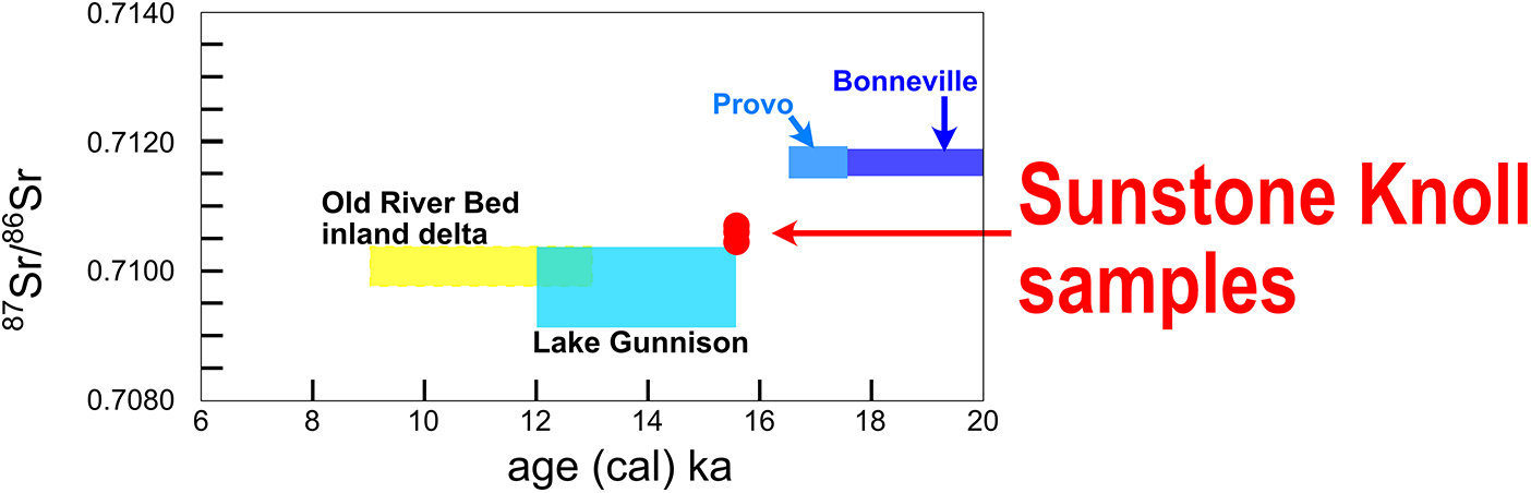
The 87Sr/86Sr analysis of the three Anodonta shells collected at Sunstone Knoll yielded 87Sr/86Sr ratios of 0.71059, 0.71064, and 0.71049 (Fig. 4, Table 5). Averaging these values yields an 87Sr/86Sr value of 0.71057 for the body of water that existed during the formation of the Sunstone Knoll spit.
Plot showing the ranges of strontium-isotope measurements from deposits of the Old River Bed (ORB) inland delta (north of the Sevier basin, fed by waters by overflow along the ORB river from Lake Gunnison, and later by groundwater flow from the Sevier basin (Gilbert, Reference Gilbert1890; Oviatt et al., Reference Oviatt, Madsen and Schmitt2003; Rhode and Louderback, Reference Rhode, Louderback, Madsen, Schmitt and Page2015; Bradbury et al., Reference Bradbury, Jewell, Fernandez, Lerback, DeGraffenried and Petersen2021; Palacios-Fest et al., Reference Palacios-Fest, Duke, Young, Kirk and Oviatt2021), and the approximate strontium-isotope ranges for Lake Bonneville before (“Bonneville”) and after (“Provo”) the Bonneville flood at approximately 17.5 cal ka (Hart et al., Reference Hart, Quade, Madsen, Kaufman and Oviatt2004; Pedone and Oviatt, Reference Pedone, Oviatt, Oviatt and Shroder2016; Oviatt, Reference Oviatt2020).

Anodonta 87Sr/86Sr ratios.a

a Uncertainty was estimated from Standard Reference Material 987 (National Institute of Standards and Technology, Gaithersburg, MD, USA), which was measured repeatedly along shells with an average value of 0.70131 ± 0.00002 (1σ, n = 37).
b Datum NAD83; all samples were collected from the sand and gravel of the Sunstone Knoll spit, within about 1 vertical meter; elevation about 1397 m. See footnote a in Table 2 for an explanation for why no adjustment for isostatic rebound is appropriate.
Discussion
The ORBT
The ORBT, the lowest point on the topographic divide between the Sevier basin to the south and the Great Salt Lake basin to the north, is a broad, low-gradient pass, formed in fine-grained unconsolidated sediment of probable lacustrine, aeolian, and fluvial origin (Oviatt, Reference Oviatt1989). The threshold is not a well-defined sharp point on bedrock.
The modern drainage divide at the ORBT consists of fine-grained alluvial and aeolian sediment from sources both east and west of the threshold area (probably reworked from the fine-grained sediment that was already there; Oviatt, Reference Oviatt1988, Reference Oviatt1989). This alluvial fill on the modern landscape makes it difficult or impossible to determine the exact configuration of the ORBT as it would have appeared when Lake Gunnison was overflowing. We think that by the end of the overflow period, the river exiting Lake Gunnison along the ORB valley, known as the ORB river, may have traversed at least 15 km of fine-grained sediment at the ORBT (roughly between 39.825°N, 112.762°W and 39.692°N, 112.735°W) with a low gradient. Using the modern topography as a guide (as depicted on the Crater Bench Reservoir, Erickson Wash SW, and Keg Mtn. Ranch 7.5-minute USGS topographic quadrangle maps), the average modern gradient of the ground surface along the probable course of the ORB river is gentler south of latitude 39.748°N (on the order of 0.0001) than it is north of that latitude (on the order of 0.001). Although it is tempting to think that the Late Pleistocene ORBT was near the modern change in ground-surface gradient (about 39.748°N, 112.740°W), a large ephemeral wash has built a post-Bonneville alluvial fan at this site. In the absence of subsurface data in this area, the location of the Late Pleistocene ORBT cannot be determined precisely.
As the level of Lake Bonneville dropped to the elevation of the ORBT, the threshold area gradually emerged from the falling lake. The river that flowed out of the lake in the Sevier basin would have cut down into the fine-grained sediment of the ORBT, thus causing the threshold area to become broader, with the reach of the river that crossed the divide becoming longer and the rate of downcutting decreasing through time (as inferred from basic geomorphic principles, although there is no way of reconstructing this with certainty; Gilbert, Reference Gilbert1890; Madsen et al., Reference Madsen, Oviatt, Young, Page, Madsen, Schmitt and Page2015; Oviatt et al., Reference Oviatt, Young and Duke2024). The elevations of the ORBT at the beginning and end of overflow, as derived from this study, were 1398 and 1390 m asl (Fig. 5). We are aware of no break in lacustrine sedimentation during Lake Gunnison time (Oviatt, Reference Oviatt1988; personal observations by C.G. Oviatt, 1980s to the present); in other words, there is no evidence that overflow was not continuous for the duration of that period.
Schematic topographic profile of the Sevier Desert basin, along a hypothetical line that includes Sunstone Knoll and the approximate position of the Old River Bed threshold (ORBT). The level of early Lake Gunnison (ELG; ∼1398 m) is shown with a blue dashed line—this early phase of Lake Gunnison formed the spit at Sunstone Knoll, and the level of late Lake Gunnison (LLG; ∼1390 m) is shown in a solid blue line (refer to the map in Figure 1). Lake Gunnison overflowed down the Old River Bed (ORB) river toward the ORB inland delta in the Great Salt Lake basin.

A theoretical possibility for an explanation of why the ORBT was 8 m higher at the beginning of overflow of Lake Gunnison versus later in the history of the lake (1398 vs. 1390 m) is related to isostatic rebound. After Lake Bonneville dropped below the Provo shoreline, isostatic rebound of the basin recommenced (presumably all the isostatic rebound in response to the removal of ∼125 m of water load during the Bonneville flood had been completed by the end of Provo time [Miller et al., Reference Miller, Oviatt and McGeehin2013], an interpretation that needs further testing). However, regardless of whether all rebound in response to water removal during the Bonneville flood had been completed, the removal of approximately 70 m of water load when Lake Bonneville dropped below the Provo shoreline to the elevation of the ORBT would have initiated or intensified rebound in the center of the basin. The ORBT is almost 70 km north of Sunstone Knoll and in line with the area of maximum rebound in the basin, roughly 150 km away. Therefore, the rate of rebound was probably greater in the ORBT area than at Sunstone Knoll. However, insufficient data exist concerning the isostatic history of the basin (Bills et al., Reference Bills, Currey and Marshall1994, Reference Bills, Wambeam, Currey and Gwynn2002), including new information about the chronology of Lake Bonneville reported in this paper and elsewhere, to quantify the rebound effect for any particular time and place. For this reason, we have chosen to bypass the untested rebound hypothesis and instead focus on the potential erosion of the threshold described in this paper. Whether or not isostatic rebound was a factor, erosion of the threshold as overflow proceeded definitely happened, even if it is not possible to document all its historical details.
Radiocarbon and OSL ages
A fluctuating lake, typical of closed basins, would not produce a prograded spit having a near-constant surface elevation. Because the crests of both the reconstructed Sunstone Knoll spit and the Bitterweed spit (Oviatt, Reference Oviatt1988) are nearly uniform in their respective elevations, the lake that created those spits had a nearly uniform surface elevation as they formed. Three 14C ages listed in Table 2 (GX-6776, 12.1 cal ka [Bitterweed spit], CA-33979, 13.1 cal ka [an unnamed spit], Beta-17883, 13.2 cal ka [the same unnamed spit]) are for Anodonta shells from locations near the ends of Lake Gunnison spits deposited when Lake Gunnison had an elevation of 1390 m. Those three ages suggest that Lake Gunnison maintained an elevation of 1390 m for more than 1000 years (i.e., 13 cal ka − 12 cal ka), first building the unnamed spit and later building the Bitterweed spit, both by progradation of sand and gravel from alluvial fans about 10 km away. At this point, data do not exist for determining the date when overflowing Lake Gunnison had dropped to 1390 m from 1398 m. However, the total duration of overflow can be determined. Based on the 14C and OSL dates reported in this paper, the Sunstone Knoll spit formed 15.5 cal ka at the beginning of overflow at 1398 m, and thus the total overflow period may have been about 3.5 ka in duration (15.5 − 12 cal ka).
The approximate end of the overflow of Lake Gunnison is similar in age to the culmination of the Currey cycle of Great Salt Lake, dated to about 12.7 cal ka (Oviatt et al., Reference Oviatt, Young and Duke2024). The idea that Lake Gunnison was the same age as a lake at a lower elevation in the Great Salt Lake basin (including the Great Salt Lake Desert [GSLD] part of that basin) is not new. Gilbert (Reference Gilbert1890, plate XXXI) showed a lake (he did not call it “Lake Gunnison”) in the Sevier basin overflowing at the ORBT (he called it “Divide between Drainage of Salt and Sevier Lakes” and showed it approximately 15 km south of the location of modern ORBT), then a river flowing down the ORB and emptying into an unnamed lake in the GSLD. Currey and James (Reference Currey, James, Madsen and O’Connell1982, p. 34) said that Lake Gunnison overflowed at the ORBT, then flowed down the ORB river to a lake in the GSLD, which they called the “Gilbert Shoreline arm of Lake Bonneville.” Currey and James (Reference Currey, James, Madsen and O’Connell1982) thought the ORBT had been isostatically rebounded to 1396 m, but were referring to the approximate modern elevation of the threshold and did not take into account the post-Bonneville alluvial fill at the threshold (Oviatt, Reference Oviatt1989). Currey (Reference Currey1982) showed Lake Gunnison in the Sevier basin overflowing at the ORBT, flowing down the Old River Bed, and into the lake in the GSLD at what he described as the “Gilbert shoreline” (however, as we know now, there is no shoreline at the place where he thought the ORB river entered the lake in the GSLD; Oviatt, Reference Oviatt2014). Currey (Reference Currey1990, fig. 13) showed a “paleolake” in the Sevier Desert overflowing down the ORB river to a lake in the GSLD at the “Gilbert shoreline.”
It is now clear that the so-called Gilbert shoreline in the Great Salt Lake basin is not a real shoreline, but the lake cycle commonly attributed to the formation of the Gilbert shoreline was real, and is now called the Currey cycle of Great Salt Lake (Oviatt et al., Reference Oviatt, Young and Duke2024). Although information is not available in 2025 for the precise outline of the Currey cycle lake to be mapped, the scientific evolution of the idea of a lake (the Currey cycle), coincident in time with the Younger Dryas paleoclimatic event, has been discussed in the literature (Oviatt et al., Reference Oviatt, Miller, McGeehin, Zachary and Mahan2005, Reference Oviatt, Young and Duke2024; Oviatt, Reference Oviatt2014).
Implications of Anodonta 87Sr/86Sr ratios
The three Anodonta shells analyzed for this study have an average 87Sr/86Sr ratio of 0.71057, with a range of 0.71049 to 0.71064 (Table 5). The range measured for 87Sr/86Sr ratios of shells from Lake Gunnison is 0.70930–0.71049 (Hart et al., Reference Hart, Quade, Madsen, Kaufman and Oviatt2004). Lake Bonneville carbonates have 87Sr/86Sr ratios between 0.71129 and 0.71175 (Hart et al., Reference Hart, Quade, Madsen, Kaufman and Oviatt2004; Pedone and Oviatt, Reference Pedone, Oviatt, Oviatt and Shroder2016). Therefore, all of the Sunstone Knoll 87Sr/86Sr ratios have values that are consistent with a body of water whose 87Sr/86Sr ratio closely matched that of Lake Gunnison (Fig. 4).
The Regressive Phase of Lake Bonneville
Godsey et al. (Reference Godsey, Oviatt, Miller and Chan2011) concluded that Lake Bonneville began its regressive phase and began to drop below the elevation of the Provo shoreline at ∼15 cal ka. The radiocarbon and OSL ages reported in this study (Tables 1, 4A, and 4B), indicate that the Sunstone Knoll spit formed at ∼15.5 cal ka, an interpretation that conflicts with the interpretation presented in Godsey et al. (Reference Godsey, Oviatt, Miller and Chan2011), although not necessarily with their results, as those results have high analytical uncertainty ranges. We consider the dates from the spit at Sunstone Knoll reported here to be more internally consistent and reliable than the dates for the Lake Bonneville regression used by Godsey et al. (Reference Godsey, Oviatt, Miller and Chan2011).
The interpretation that lake elevations had fallen to the ∼1398 m elevation of the spit at Sunstone Knoll by ∼15.5 cal ka is consistent with cosmogenic dates reported by Laabs et al. (Reference Laabs, Oviatt and Jewell2019), which suggest the lake dropped below the Provo shoreline about 16.5 cal ka. The 87Sr/86Sr ratios of Anodonta from the Sunstone Knoll spit are similar to, but slightly higher than, the expected values for Lake Gunnison and do not match ratios of samples from older Lake Bonneville sediments; this mismatch indicates that segmentation of Lake Bonneville into its southern and northern bodies was complete by the time of spit formation at Sunstone Knoll.
Conclusions
The radiocarbon ages and the overlapping OSL age reported here indicate that the Sunstone Knoll spit was deposited at about 15.5 cal ka, and that Lake Bonneville had regressed ∼70 m below the Provo shoreline to an elevation of ∼1398 m asl by this time. This suggests that Lake Bonneville had regressed to the elevation of the ORBT before the onset of the Bølling-Allerød warming event, which has been dated to ∼14.7 cal ka (Rasmussen et al., Reference Rasmussen, Anderson, Svensson, Steffensen, Vinther, Clausen and Siggaard-Andersen2006). The date of ∼15.5 cal ka is 500 years older than the ∼15 cal ka date previously proposed for the beginning of the regressive phase of Lake Bonneville by Godsey et al. (Reference Godsey, Oviatt, Miller and Chan2011) and Oviatt (Reference Oviatt2015).
Our new information and interpretation will inform future research that investigates climate change in the Great Basin during the Late Pleistocene and will be useful in investigations of previously unanswered questions about the regressive phase of Lake Bonneville. One thing that ought to be done at some point is to obtain additional OSL ages from the spit at Sunstone Knoll. This would help test the viability of the one OSL date we have so far. Further radiocarbon dating at Sunstone Knoll may not be productive, because no materials other than Anodonta shells are available for dating, and it may not be possible to improve on the existing cluster of six dates.
This study is an attempt to refine one of the details of the chronological record of Lake Bonneville. As one of the two main subbasins of the Bonneville basin, the Sevier basin and its connection to the main body is hydrologically important. Future studies might include an investigation of the nature of that connection during the transgressive phase. As always, continued work on the details of the Lake Bonneville chronology are needed, not necessarily directly related to the Sevier/main body connections (for instance, more work on the age of the Provo shoreline and more work on the isostatic history of the basin, are needed).
Supplementary material
The supplementary material for this article can be found at https://doi.org/10.1017/qua.2025.10048.
Acknowledgments
We thank Art Lucas and Lucas Newman Science and Technologies for conducting high-resolution gamma-spectrometry measurements, as well as Jennifer Roozeboom (née Boswell), Yuxin Fan, and Matt Rankin for assistance with OSL analyses. The authors would like to recognize their families as well. The lead author would like to recognize the medical professionals who helped him and so many others during the COVID-19 pandemic. We appreciate the constructive review comments from Marith Reheis and an anonymous reviewer.
Financial Support
University Small Research Grant (USRG no. 2618) awarded to JQGS from Kansas State University and funds from NSF grant no. 139414 awarded to CGO helped support the field sampling and analytical aspects of the radiocarbon, OSL, and strontium-isotope components of this research. A Faculty Development Award (FDA no. 2600) awarded to JQGS from Kansas State University helped support attendance at the Seventh New World Luminescence Dating and Dosimetry Workshop (NWLDDW) at UQAM, Montréal, where initial OSL data were presented. No other financial support was used for this project.
Competing Interests
No competing interests exist between any of the coauthors of this paper and other entities.