

Introduction
Why can’t I be a guy with a 400-mile lens, a tourist, taking pictures and sticking them on the Internet?Footnote 1
On a trip to southern Sudan in October 2010, George Clooney and Enough Project co-founder John Prendergast had an idea. What if they could watch the warlords? Monitor them just like the paparazzi spy on Clooney? Back in the United States, the actor decided to change this situation by founding the Satellite Sentinel Project – with the aim of using high-resolution satellite remote sensing imagery to detect and prevent human rights abuses in Sudan and South Sudan.Footnote 2 The project broke new ground by using non-classified satellite imagery not only to document past human rights abuses but also to help prevent future violence against local civilians by collecting, analysing, and combining large amounts of satellite data almost in real time.Footnote 3 Also, politically, the project was a novelty in that it united the social capital of humanitarian NGOs such as the Enough Project with the expertise in imagery analysis of UNOSAT, scientific advice from Harvard researchers, the technological know-how and software support of Google, high-resolution satellite images provided by DigitalGlobe (the leading commercial provider of satellite imagery), and the cultural as well as economic capital of Hollywood celebrities – including, for example, Matt Damon and Brad Pitt.Footnote 4
The example of the Satellite Sentinel Project is representative of novel (networks of) non-governmental actors using commercially available satellite technologies to detect human rights abuses and war crimes, to monitor eco-crimes and environmental degradation, or to provide humanitarian assistance in crisis situations.Footnote 5 The increasing availability of non-classified, high-resolution satellite imagery equips such non-governmental actors with surveillance capabilities that have long been the monopoly of a few satellite superpowers. With this, the ‘view from nowhere’ is said to have disciplinary effects on the subjects under surveillance – as they would adapt their behaviour in light of the omnipresent risks arising from being monitored. The opening and commercialisation of satellite technologies – alongside the increasing use of them by non-state actors – thus might lead to considerable shifts of political power within contemporary global governance.
This all could be taken as evidence of a further ‘governmentalization of civil society’,Footnote 6 wherein non-governmental actors are increasingly taking up governmental functions and performing tasks previously carried out by states – from monitoring compliance with international treaties to protecting the environment and vulnerable populations in crisis regions – often in cooperation with governmental actors. However the increasing availability of and technical advancements in satellite remote sensing imagery have also allowed for the emergence of what could be called ‘visual activism’, and with it ‘imagery activists’.Footnote 7 Different actors including NGOs, artists, journalists, or transnational advocacy coalitions are now using satellite imagery in subversive, anti-statist, or counterhegemonic ways. As put by Chris Perkins and Martin Dodge, ‘[these] counterhegemonic strategies can challenge dominant social forces by arguing for a platform of action to disrupt hegemonic cultural norms, and in so doing “countering” dominant discourses and offering a challenge to the ongoing mechanics of state power.’Footnote 8
A lot of ink has been spilled in IR debates over the past twenty years on the role of NGOs as part of the transformation from international government to global governance.Footnote 9 Also, the question of how NGOs are using global media and new information technologies to increase global transparency, create transnational publics, or even some form of a global civil society has been discussed at length.Footnote 10 However, the debate on the politics of non-governmental remote sensing occurring in Cultural Studies and Geography has so far gone rather unnoticed by the broader International Relations (IR) literature. In this article we thus set out to close this gap and to introduce the debate on non-governmental remote sensing and satellite-based activism to a broader IR audience. We investigate the political implications of the increasing use of high-resolution satellite intelligence by non-governmental actors. More concretely, we critically examine the claim that new forms of private remote sensing bear counterhegemonic potential.Footnote 11 We show that instead of challenging statist representations of the global order, NGOs are often complicit in reproducing a dominant statist gaze of satellite remote sensing and its underlying form(s) of visuality.
We support this contention by analysing forms of non-governmental remote sensing and visual activism in the fields of human rights and environmental protection. We have selected them for two reasons. First, non-governmental actors play an important role in the governance architectures of both policy fields. Second, satellite technology has been vigorously applied in these sectors.Footnote 12 In humanitarian governance, this goes back to the centrality of visual evidence in the documentation and prosecution of human rights abuse. In environmental governance, satellite remote sensing is crucial as it allows the detection and monitoring of large-scale environmental changes that would otherwise remain hidden from the human eye.
It is important to note that we do not understand both fields as two entirely distinct cases, which could be compared along a fixed set of variables. Comparing the two rather allows us to paint a more comprehensive picture of non-governmental remote sensing and to check for possible analytical biases of a single case study.Footnote 13 For example, one might argue that shortcomings of visual activism in the field of human rights are a general feature of privatised humanitarian governance rather than a unique feature of satellite-based activism; or that the problems result from the difficulties of identifying human action on satellite imagery. By studying a second field of satellite-based activism in a different context and with a different subject under surveillance (that is, large-scale environmental change and hence something that can perfectly be visualised on satellite images) we can double-check valid objections like these.
In both fields, we investigate major projects of non-governmental remote sensing. In the case of human rights monitoring, this includes Amnesty International’s (AI) flagship project Remote Sensing for Human RightsFootnote 14 and the Geospatial Technologies ProjectFootnote 15 of the American Association for the Advancement of Science (AAAS). In the case of environmental monitoring, meanwhile, we examine Global Forest Watch of the World Resource Institute (WRI).Footnote 16 These projects can be considered as paradigmatic cases for our analysis. Most importantly, they have been described as ideal-typical examples of international visual activism in the literature. Furthemore, our aim in this article is to trace novel forms of non-governmental authority through the privatisation of the statist satellite gaze. We thus concentrate on major NGOs, which have the required capacities to buy, analyse, and disseminate primary satellite imagery. Our sample thus excludes NGOs and social movements that use publicly available (secondary) satellite imagery such as Google Earth, or related geospatial data including participatory mapping, volunteered- or crowd-sourced geographic information.Footnote 17
We scrutinise these examples of non-governmental satellite remote sensing from three angles. First, we are interested in the practices of non-governmental remote sensing. This means to investigate how advocacy groups use remote sensing data, and what its core purpose is. Second, we examine the forms of visuality that are produced by these modes of satellite-based activism. For this we ask whether there is a non-governmental way of seeing, and whether the private use of satellite imagery challenges the dominant statist gaze of remote sensing. Third, we discuss the power effects and the political implications of non-governmental ways of ‘sensing the ground’. Our methodology is guided by Gillian Rose’s (2016) approach of visual discourse analysis, which allows for the study of the semantic effects of visuals and images (that is, the question of how satellite images produce meaning by framing issues in certain ways) – as well as the sites and practices of image production and circulation.Footnote 18 Our research strategy involves active experimentation with the interactive online platforms provided by the different projects, as well as a close review of their homepages, reports, online fora, and blog posts. Relevant secondary literature is also consulted so as to contextualise and corroborate our findings.
The next section engages with the debates on the empowerment of non-state actors by remote sensing technologies and the emergence of new forms of visual activism. The subsequent sections present our two case studies, which are both structured along the lines of the above-outlined research questions. The conclusion discusses the broader implications of our findings for the wider field of IR, and highlights some possible avenues for further research.
The rise of satellite-based activism
The assumption that the globalisation process unfolding ever since the end of the Cold War has given non-governmental actors a new role in world politics has become one of the truisms of IR thinking. Also the role of new information technologies such as the Internet in the emergence of decentralised, non-governmental ‘spheres of authority’Footnote 19 has been discussed at length.Footnote 20 The importance of satellite remote sensing as a source of non-governmental authority in world politics has on the contrary received far less, or almost no attention in IR.Footnote 21 Yet, if a crucial source of legitimacy for NGOs in world politics is the creation of transparency and the capacity to bring new issues to the political agenda, then satellite imagery represents a key means of attaining private authority.
IR’s lack of attention for non-governmental forms of satellite remote sensing might be due to the fact that the latter is only a very recent development. Satellites with a global reach have traditionally belonged to the exclusive domain of the state. Since the advent of satellite technology at the end of the 1950s, militaries, intelligence agencies, and international organisations have kept track of developments unfolding on the ground elsewhere – legitimising a range of diplomatic, military, and political actions that include warnings, inspections, sanctions, and interventions. Satellites have, consequently, become synonymous with official forms of knowledge.Footnote 22 Developments in technology and legislation in the early 1990s have led to a gradual weakening of the state’s monopoly on the view from above, however. In 1992 the US administration accelerated its efforts to privatise the Landsat program and to open its remote sensing industry, with the passing of the Land Remote Sensing Policy Act of 1992.Footnote 23 The subsequent commercialisation process was accompanied by technological developments such as the rise of the personal computer and the spread of Geoinformation Services (GIS) software to read, process, and interpret digital maps – taken together, these multiplied the number of users of new ‘open intelligence’ products.Footnote 24
As a result of this increasing accessibility of satellite-generated geodata, NGOs in the fields of environmental, development, and security policy started began exploring the potentials of the technology for their work, in particular in the humanitarian and environmental fields. For NGOs satellite imagery opened up new possibilities for political engagement. Satellite imagery, first, enabled them to lift the veil of sovereignty to reveal human rights abuses, eco-crimes, or the violation of international treaties on foreign soil.Footnote 25 Second, it also allowed humanitarian and environmental NGOs – who often put themselves in danger in the course of local fieldwork – to intervene in hostile environments ‘at a distance’.Footnote 26 Finally, NGOs used the newly available imagery to make abstract, complex, and distant problems like deforestation and other environmental problems comprehensible to a broader public, and to create solidarity with and a sense of pity for distant populations.Footnote 27 The use of satellite images helped render human suffering visible, and – via their circulation in the mass media – made ordinary people in the Western world witnesses to human rights violations, food crises, or natural disasters.
An important consequence of this exercising of a ‘private’ view from above is, according to scholars who have detailed the rise of imagery activists,Footnote 28 that it challenges the state’s hegemonic way of seeing and showing the world.Footnote 29 Karin Litfin was among the first social science scholars to argue that the empowerment of non-state actors by remote sensing technologies could lead to a ‘globalization of transparency and new networks of surveillance’.Footnote 30 Deprived of the ability to control information about developments in their territories, states would be subject to a disciplinary gaze exercised by private advocacy groups. On this basis, NGOs that use remote sensing imagery are said to have become quasi ‘intelligence agencies’ reconnoitering the notorious secrecy of states. Sean Aday and Steven Livingston, for example, examine the use of commercial remote sensing by a non-profit security think tank, the Institute for Science and International Security (ISIS), in the case of the Iranian nuclear program. Using information supplied by a dissident group, ISIS purchased satellite photographs from a commercial provider of space imaging, DigitalGlobe, and claimed in December 2002 to have found previously unknown nuclear facilities in Iran. Sean Aday and Steven Livingston suggest that this disclosure by ISIS helped force the US administration into acknowledging the existence of an Iranian nuclear enrichment program at a time when US politics were preoccupied with the imminent invasion of Iraq – it may also have pressed the Iranian government into admitting international inspectors to the sites in question.
Perkins and Dodge argue that with the increasing availability of remote sensing data on the Internet, using satellite imagery in new, subversive, and counterhegemonic ways has become possible too. In particular, cooperation with independent media would enable NGOs to challenge statist discourses – and thereby ‘weaken state hegemony’.Footnote 31 Accordingly, the ‘scopic regime’Footnote 32 of satellite imagery is said to have certain characteristics that make it particularly powerful in breaking with dominant, state-led discourses. Compared to other visual representations such as maps or graphs it is easily accessible, has a certain aesthetic appeal, and purports to give a direct representation of the reality on the ground. At the same time, the view from above makes satellite images – unlike photographic ones – appear to be distanced, neutral, and objective.Footnote 33 Satellites, thus, inhere a particular epistemology: they are not only believed to transcend natural obstacles and elemental boundaries, since geostationary satellites are capable of recording images at any time and from anywhere (similar to the all-seeing eye of God), but also assumed to reveal hidden, unknown, or secret sites, ones which would otherwise remain invisible or inaccessible to outsiders. Therefore, the possibility of purchasing high-resolution images on the open market would even allow for the redirecting of remote sensing capabilities and turning them against the observers (for example, traditional satellite powers), by revealing clandestine military bases or intelligence infrastructures; ample reasons why NGOs engage remote sensing technologies.Footnote 34 However, it is important to note that satellites only produce particular knowledge.Footnote 35 For example, even though consensus on what a satellite image depicts can be reached, it does not tell us what the picture means, why things are as they are or what has to be done about it.Footnote 36 In other words, the complexities on the ground can easily be obscured by looking from above. The ambiguity of satellite imagery points to the need to take into consideration the political context through which it operates and is made meaningful.
Satellite-based advocacy, or visual activism, is thus understood to contest state practices of looking.Footnote 37 Non-governmental remote sensing promises to increase global accountability and transparency by making knowledge claims, doing so with the intention of directly affecting processes in and of international relations. In other words, the distinct cluster of non-state entities – including civil society groups, non-governmental organisations, multinational corporations, academic networks, journalists, artists, celebrities, and also ‘ordinary’ people – that now exists is not only engaging the global politics of knowledge, but, more importantly, constituting it. Private humanitarian agencies, environmental NGOs, human rights groups, and other advocacy networks hence participate in making claims about the international by means of distant observation. Satellite-based activism is therefore centrally involved in the globalisation of non-state agency and in enabling the exercise of global governance functions by private actors; of these, several concern human rights campaigning and environmental monitoring. In the following sections we seek to corroborate these claims by taking a closer look at concrete projects of non-governmental remote sensing in the fields of human rights and environmental governance.
Geopolitics of human rights remote sensing
Human rights advocacy has a special relationship to visual culture, making it a distinct form of visual activism. Abu Ghraib, the prison complex in which Iraqi inmates were tortured by US Army personnel, is a good example hereof. While written reports and oral testimonies about what was going on in Abu Ghraib had been known about for some time, only visual imagery, it seems, provided sufficient evidence of human rights violations to elicit international condemnation and official investigations.Footnote 38 In this way, photographs showing torture and abuse were setting the conditions for meaningful action in domestic and international politics.
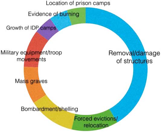
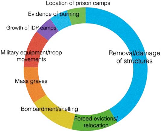
Amnesty International, which brought to light the human rights abuses occurring in Abu Ghraib, has historically been one of the main drivers of linking technologies of visualisation with human rights activism. Besides photographic documentation, AI and other international human rights groups have also eagerly embraced geospatial technologies – which include geographic information systems, mapping tools, and remote sensing.Footnote 39 The use of satellite-based data has become so important for global advocacy groups like AI, AAAS, Human Rights Watch (HRW), or the International Committee of the Red Cross that it features centrally in their international human rights campaigns. One example is the flagship program Remote Sensing for Human Rights of the US section of AI, which features, among other things, the prominent Eyes on Darfur Project. Set up in 2008, the program provides what it calls a ‘repository of the use of remote sensing for human rights research’.Footnote 40 Another example is the aforementioned landmark Geospatial Technologies Project of the AAAS,Footnote 41 which has used remote sensing data since 2005 for the advancement of environmental and human security. Satellite vision has, hence, become an integral part of humanitarian practice. Figure 1 below illustrates the different subjects of satellite imagery-based human rights investigations by AI.Footnote 42 As is shown therein, the identification of damaged or removed structures makes up the major part of projects. For example, in the case of Darfur (the western part of Sudan) international human rights groups and private initiatives – including AI, the Harvard Humanitarian Project, and the Yale University Genocide Studies Program – have used satellite imagery to document the destruction of villages and the disappearance of agricultural cropland. Further applications include the detection of troop movements, the locating of military equipment, the uncovering of signs of artillery shelling and bombardment, and the detection of secret facilities such as prison camps.
Subjects of investigation in AI human rights remote sensing projects. Source: Authors’ own compilation.
The promise of human rights remote sensing
Satellite-based activism draws on a discourse of science and technology with the aim, to put it simply, to show and tell – and not to assert and persuade. For AI, which partners with AAAS on human rights documentation, remote sensing is part of a broader effort to embed scientific practice into human rights activism. For instance, AI’s summary report evaluated that the use of geospatial technologies increased the efficacy of projects and the credibility of its claims.Footnote 43 It also highlighted the ‘self-explanatory’ character of satellite images, which provide ‘powerful’ and ‘insightful’ evidence of human rights violations.Footnote 44 The AAAS report on satellite-based human rights applications argued similar.Footnote 45 To advance human rights campaigning, non-governmental remote sensing serves several key purposes: to raise the awareness of global society regarding human rights violations, to document abuse in previously hard-to-access areas, to prevent offenses from even happening through constant supervision, to ensure justice for victims and the accountability of perpetrators, and to challenge official assumptions about and state practices of concealment.Footnote 46 While the embracing of geospatial technologies suggests the increasing linkage of activism with visual culture, it also articulates a sociotechnological rationality after which humanitarian reasoning and activist practice cannot be separated from their techno-semiotic representation.
In this vein AI champions the gist or what can be called the ‘promise’ of remote sensing: as satellite-based data and its corresponding analysis cannot be ‘intimidated or threatened’ by the perpetrators of human rights violations, the technology provides ‘compelling visual evidence’ of abuse – and therefore cannot be dismissed.Footnote 47 Then executive director of Amnesty International Larry Cox put it this way: ‘What this satellite technology does, it makes it possible to break down those walls of secrecy. Not only to get information, but to get information in a way that’s irrefutable.’Footnote 48 The promise of human rights remote sensing has also been lauded by recent scholarship too.Footnote 49 In some cases, knowledge production via satellites is preferred over on-the-ground fieldwork indicating a hierarchy between ‘knowledge from above’ versus ‘knowledge on the ground’.
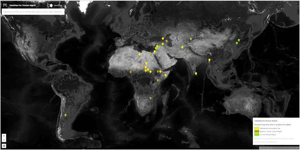
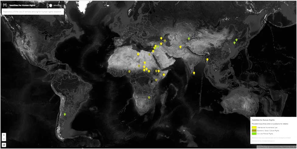
The promise of remote sensing as a vehicle of visual human rights activism is, however, contradicted by the specific geographic patterns of human rights mapping. A closer look at AI’s repository or at AAAS’s case study location shows that the technological apparatus and related processes of satellite-based activism are only aligned to specific areas of interest (see Figure 2 below): Africa, Asia, the Middle East, and South America. These regions are often referred to as ‘non-Western’, the ‘Global South’, or the ‘Third World’ in geopolitical discourse. Moreover, the major focus of all human rights remote sensing projects is on two world regions: sub-Saharan Africa and the MENA (Middle East and North Africa) region. These are regions that – in the dominant Western geopolitical imaginaries – are marked by their ‘otherness’ (MENA as a ‘Muslim’ region, sub-Saharan Africa as the ‘dark continent’, etc.). Other spaces of humanitarian exclusion – for example Australia, Europe, and the US, being sites in the ‘West’, the ‘Global North’, or the ‘First World’ – are entirely overlooked meanwhile.
Screenshot of the human rights mapping of Amnesty International. Source: {http://www.amnestyusa.org/research/science-for-human-rights/remote-sensing-for-human-rights} accessed 20 February 2017.
Without restating in detail the well-rehearsed general criticisms of human rights advocacy – which comprise for instance accusations of serving only the interests of powerful states and the failure to adequately address the root causes of abuse or the marginalisation of other social justice efforts – it should be noted that with human rights monitoring crucially drawing on new technologies of observation, the field is complicit in both reflecting and reproducing older colonial discourses of difference and exclusion.Footnote 50 As such, while human rights are normatively universal their knowledge production is in fact inherently particular. Because the promise of satellite imaging – the ability to report any human rights abuses due to the technology’s allegedly extra-discursive position – can only be fulfilled in reserved spaces of humanitarian concern, human rights remote sensing intersects with other popular geopolitical imaginations of the Third World as requiring outside intervention or ‘from above’ supervision. In this way, visual activism in the human rights field reifies a global discourse of alterity – thereby isolating a needy Global South from a caring Global North.Footnote 51
This is not to suggest that AI, or other human rights groups for that matter, shuns pointing out or criticising human rights violations in Europe or the US. On the contrary, AI has been a vocal critic of Australian, European, and US human rights policies ever since it was founded in the 1960s. It is, indeed, precisely this track record that gives us reason to ask why the techno-humanitarian gaze of AI and AAAS – or, for that matter, the promise of remote sensing at large – only applies to ‘non-Western’ geographies and not also to places, sites, or developments in ‘the West’. For if, as AI has claimed, the view from above cannot be intimidated or threatened then other spaces of humanitarian attention could be scrutinised as well by human rights-related remote sensing. Examples are: the US prison complex in Guantánamo Bay, Cuba (for example, observing changes to material structures and articulating certain knowledge claims, as in the case of the human rights satellite imaging of North Korea); so called ‘black sites’ in Europe intended for the detention and interrogation of terror suspects; atrocities committed during the conflict in Ukraine by the warring parties (including NATO-backed Ukrainian armed forces); or, the structural violence of refugee camps within the EU. It becomes clear that the satellite practices of looking that are solely exercised on ‘non-Western’ geographies – exposing certain conditions and developments involving the above-described image analysis and interpretation strategies – could also be applied here, but they are not; this raises questions unfortunately only rarely addressed in recent studies of human rights remote sensing.Footnote 52
Explaining satellites’ selective gaze
There is, therefore, a need to ask how the selective gaze of human rights remote sensing can be best explained. One obvious answer for the exclusion of Western spaces of non-governmental supervision is ‘shutter control’ – the informal rule according to which the US government restricts access to commercial satellite imagery in the interest of national security. However shutter control is rarely applied, and has never officially been exercised due to concerns related to the First Amendment to the US constitution – which prohibits infringement on, among other things, the freedom of speech and the freedom of the press.Footnote 53 Indeed, in the analysed material there is only one case in which governmental suppression of remote sensing data has impeded AI’s work: this was the case of Hezbollah attacks on northern Israeli cities.Footnote 54 A second obvious argument – that restricted access to certain geographic areas is a peculiarity only of the Global South – does not hold true under closer inspection. In fact, secret sites and hidden spaces are also a reality of the Global North too.Footnote 55
We hold that besides shutter control there are several other (and more subtle) selection mechanisms that lead to the geographically selective gaze described above. These mechanisms are inscribed into what can be called the image complex of satellite remote sensing. Meg McLagan and Yates McKee have argued that the possibilities of visual activism depend upon a broader ‘image complex’ constituted by the ‘channels of circulation along which cultural forms travel, the nature of the campaigns that frame them, and the discursive platforms that display and encode them in specific truth modes’.Footnote 56 The pictures used by AI, HRW, and the AAAS are thus only the end product of a longer chain of image production.Footnote 57
The notion of the image complex points us to the fact that satellite images are part of a global ‘visual economy’Footnote 58 that is dominated by a few global satellite businesses, where only the big players in humanitarian and environmental governance such as the ones described in this article have the financial means to purchase such imagery. Satellite remote sensing is not actually ‘a view from nowhere’, as implied in AI’s description of the technology as an objective, scientific gaze at the world.Footnote 59 Rather, as Lisa Parks reminds us, it is a ‘view from somewhere’ as the capital-intensive satellite infrastructure is monopolised by a few national space agencies and multinational corporations, including Google, DigitalGlobe, and Space Imaging Corp.Footnote 60 Human rights NGOs depend on cooperation with these actors. As smaller human rights NGOs lack the financial capital, technical capabilities, and expertise to purchase, process, and analyse satellite images, only the major human rights actors can take advantage of the cooperation with the global vendors of geospatial content.
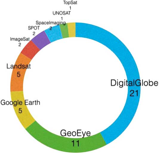
Yet, even major NGOs such as AI are heavily dependent on the big satellite technology players to acquire and analyse images. This dependence is perfectly mirrored in Figure 3 below, which shows the image sources for all projects in the AI database. The majority share of human rights remote sensing projects draws on imagery from DigitalGlobe and GeoEye, who merged in 2012 to become the largest commercial provider of satellite imagery worldwide. Only a few projects used imagery from Google Earth (which is following its own commercial interests anyway) or NASA’s Landsat program (free to access, but only available at low spatial resolutions).
Image sources of human rights remote sensing projects. Source: Authors’ own compilation.
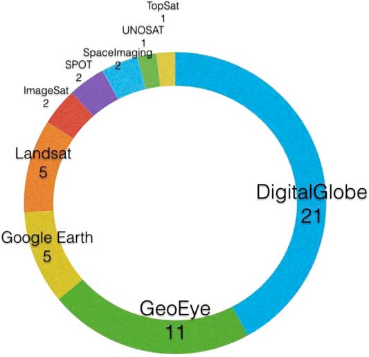
As elaborated by the AAAS, an NGO that seeks to investigate human rights abuses in a certain location cannot simply commission the required satellite imagery.Footnote 61 Apart from the US government, which can commission imagery of any place on the globe, the question of where and when satellite images are taken is determined by commercial interests. These are defined mainly by major customers. Low-budget requests for satellite images – such as by the AAAS or AI – are given the lowest priority, and hence NGOs’ chances of acquiring images of an exact location and date for human rights inspections is very limited.Footnote 62 Thus the question of which human rights abuses can be monitored with the help of remote sensing images largely depends on the profit-driven interests of businesses such as DigitalGlobe and Google. It is no coincidence that the largest number of human rights remote sensing projects have been conducted in two countries: Sudan/South Sudan and Syria (see Figure 2). In both, the major players of the image complex Google and DigitalGlobe were deeply embedded. In the case of Darfur, for example, Google Earth decided to produce new high-resolution imagery and to make it available through their Google Earth Outreach platform – one that supports the use of remote sensing by NGOs in selected cases.Footnote 63 DigitalGlobe provided AI with free-to-access satellite imagery in both cases, and even aligned its satellite constellations so as to provide better coverage of the conflict regions. So, while major NGOs popularise human rights remote sensing, for instance by means of global media coverage, in the political economy of satellite-based activism they rely on US businesses which follow their own commercial logic.
Politics of the satellite image complex
Satellite-based activism is, hence, involved in articulating a form of human rights advocacy that is elitist, exclusive, and hierarchical: for human rights satellite imaging, the spaces of exceptionality lie somewhere else. After all, the Eyes on Darfur – which joins the ranks of other high-profile initiatives targeting the western part of Sudan, including the Satellite Sentinel Project (George Clooney, Harvard Humanitarian Initiative) and the Crisis in Darfur Project (Google, the US Holocaust Memorial Museum) – are eyes on ‘the other’. In this way, human rights remote sensing is a good example of how satellite images exceed their frame of visibility – becoming part of a visual performance of the geopolitical field.Footnote 64
The activist gaze is thus not only political because looking itself is always politicalFootnote 65 but also because it is part of a scopic regime of the Third World that allows only generic ways of seeing and knowing.Footnote 66 Rather than contesting statist representations of the global order, which conform to popular political binaries including Global North/South, West/non-West, and First/Third World, human rights remote sensing is thus in fact complicit in (re)articulating dominant geopolitical discourses and established political identities. In other words, while satellite-based human rights activism is meant to speak truth to power – because the revelation of abuse also contests existing statist power structures, something that has always been at the very heart of human rights campaigning – the humanitarian gaze of the satellite is indeed already a function of power. Also, this gaze codetermines the conditions of meaningful action as it produces a particular understanding of which offenses are deserving of remote surveillance and which are not. Thus the view from above operates as a distinct field of knowledge, as it not only tells of abuse but also, more importantly, defines what even counts as (knowledge about) abuse in the first place.
Geopolitics of environmental remote sensing
Besides humanitarian governance a second common field of application of non-governmental remote sensing is environmental governance. Unlike the human rights violations and war crimes discussed in the previous section, the detection of large-scale environmental problems is only possible from a distance. The synoptic gaze of satellites allowed the discovery of global environmental problems like deforestation, desertification, ozone depletion, or the melting of the polar icecaps in the 1970s and 1980s.Footnote 67 During the Cold War, satellite images of the environment were mainly used by Earth scientists and other experts; however this changed after the aforementioned commercialisation and opening up of satellite technology from the early 1990s onward.Footnote 68
Since then, a whole range of environmental NGOs – including the Nature Conservancy and the Natural Heritage Network (both in the US), the Indonesian Forest Monitoring Network, Imazon in Brazil, the Institute for Global Environmental Studies, the WWF, as well as Greenpeace – have deployed remote sensing imagery to create public awareness of deforestation and other forms of environmental degradation.Footnote 69 These NGOs address environmentally conscious individuals and seek to empower them to become active witnesses to eco-crimes and watchmen over the Earth’s ecosystems.
The promise of visual environmental activism
The World Resources Institute (WRI) is one of the NGOs that have most consequently relied upon satellite imagery (WRI). With its Global Forest Watch (GFW) initiative, the WRI has harnessed the surveillance power of remote sensing and utilised its worldwide contacts among local activists to forge a comprehensive global forest monitoring system. In the literature, the GFW program has thus been described as a paradigmatic example of ‘NGO imagery activism’.Footnote 70 Originally established in 1997, GFW first produced atlases and reports on deforestation in hotspot regions such as the Congo Basin or Southeast Asia. In 2011 the WRI started working on a updated version of GFW, doing so by considerably expanding its network to include leading businesses in the remote sensing/GIS sector including Airbus, DigitalGlobe, Esri, and Google, international organisations such as the Global Environment Facility (GEF) and the United Nations Environment Programme (UNEP), the ministries of the environment and of development in Denmark, the Netherlands, Norway, the UK, and the US, as well as several regional and international NGOs.Footnote 71 This confirms the observation made by Litfin that non-governmental forms of remote sensing are always embedded within broader networks of state agencies, research institutions, business sponsors, or even intelligence agencies.Footnote 72
Based on the vast amount of data, technology, funding, and expertise provided by this hybrid actor network, the WRI developed an interactive online tool that allows any Internet user to monitor processes of deforestation and tree-cover change anywhere in the world. The platform fuses layers of data provided by space agencies and remote sensing businesses like DigitalGlobe, Google, NASA and Terra-i. Similar to the Google Earth platform, GFW is not a single software tool but rather a whole ‘assemblage of resources and technologies that can be mobilized to identify and monitor trouble spots and promote civil society’.Footnote 73 The GFW draws upon a techno-political promise that is similar to that made by the human rights watching campaigns discussed above. Through the combination of multiple data sources with satellite imagery at different spatial and temporal scales, an almost all-compassing surveillance becomes possible – one that comes close to a global panopticon.Footnote 74
Non-governmental satellite remote sensing thus promises authorised knowledge of (illegal) deforestation from a view that cannot be intimidated. Yet, there is also a key difference to the human rights projects above: AI and AAAS address a (passive) public audience (for example, through reports and case studies on human rights abuse), while GFW seeks to activate everyday Internet users to become ‘watchmen’ over the global forests. For this, the GFW platform allows the user to scroll through, zoom in on any location, and to activate and visually combine a whole range of social, economic, and environmental data layers. The user can choose between satellite imagery spatial resolutions – such as medium to detect broader landscape changes, or high to take a closer look at illegal forest fires – and can switch between a range of basic maps including political, topographical, or road network ones, as well as Google Earth’s and Landsat’s own satellite imagery. The new GFW interface furthermore provides the user with numerous customisable ways of analysing and visualising the different databases collected on the website. Finally, it includes elements of crowdsourcing, as its smartphone application allows users to share ‘stories’ on deforestation based on local observations – these are then geotagged and included in the GFW interactive map.Footnote 75 With its playful aesthetic – which mirrors the user experience familiar from Google Earth, and allows the user to ‘stroll’ through virtual landscapes – GFW explicitly addresses ordinary citizens as users of the platform.Footnote 76
Prima facie, GFW clearly bears a counterhegemonic potential. The platform increases transparency and prevents states such as Brazil or Indonesia from suppressing information about deforestation in their territories.Footnote 77 Moreover, it provides local environmental activists in such countries with new possibilities as to how to safely investigate eco-crimes from a distance. Through its vast actor network, which essentially includes all the major players of the above-described image complex, and with its open data policy it makes formerly restricted imagery accessible to a much wider public and that in a heretofore unknown dimension. In this sense, it provides ‘satellite data for the people’ as USAID euphorically expressed it.Footnote 78
The techno-scientific gaze of satellite forest monitoring
The promise of visual environmental activism through the GFW platform is, however, limited by the particular techno-scientific form of visuality it produces. The GFW platform reproduces a common, hegemonic Western representation of deforestation as a global ecological problem, which is abstracted from its immediate local context.Footnote 79 GFW draws upon a scientific gaze that divides the complex reality of deforestation into a set of data layers, including (satellite) information on forest change, land use (for example, managed forests, mining, palm oil), conservation (for example, protected areas), and population factors (for example, density, land rights). These layers can be combined, recombined, and visualised in different ways by GFW users. The underlying rationality is that by collecting and combining huge amounts of big geospatial data, it not only becomes possible to see the world’s surface but also to understand what is happening on the ground.Footnote 80
GFW thus represents a paradigmatic example of the lure of big geospatial data:
The parsing together of data from different registers, … places, different social actions within a grid of intelligibility that standardizes data units into a seamless globe interface, [which is] praised as having the ability to fight poverty and crime and to solve environmental crises. … Total quantification requires a depiction of the social world generated as traceable, locatable, and calculable.Footnote 81
The promise here is not only that it becomes possible to monitor processes of global deforestation, but indeed also to inquire into their root causes and defining factors.Footnote 82 The stratification of reality into a set of social, economic, political, and environmental layers through big geospatial data is problematic since it draws upon a parsing of the social and the ecological worlds that simplifies a complex socio-environmental problem like deforestation. For no matter how many data layers are added, one will not be able to grasp the complexity of a phenomenon by merely observing it from distance. The question of which layers become included and excluded, hence, point to the politics of stratification.
A key problem of the GFW platform is that it promises an entirely apolitical, scientific way of seeing. GFW seeks to depoliticise its own practice of looking by leaving the interpretation of data up to its users, the digital crowd, as the following quote demonstrates: ‘Rather than trying to present a single interpretation of a complex dataset, GFW is creating open data tools and APIs that will allow data to be applied and interpreted in customizable ways.’Footnote 83 While it is a positive development that GFW is aware of the problem of interpretation bias in remote sensing practices, the assumption that it could circumvent it simply by providing its users with the ‘raw facts’ (so as to empower them to develop their own interpretation) is problematic. For already the selection of the included (and excluded) data layers is a political process, one that has a huge impact on the possible interpretations of users. For example, the platform includes data layers on human sources of deforestation including illegal logging, palm oil production, and mining. Yet all these are situated at the local level. What is excluded is data on the global political economy of timber, the role of powerful multinational corporations and foreign investments in it, local power structures, conflicts, and their linkages thereto, as well as the historical legacies of colonial rule or neoliberal restructuring programmes that turned many developing countries into export-based single commodity (for example, timber) economies. In short, excluded are all the data layers that are required to develop a more radical and counterhegemonic interpretation of the global politics of deforestation.
The ‘climate tool’ of the GFW platform perfectly demonstrates the techno-scientific representation of deforestation. This application that was added to the platform in 2015, and allows the user to analyse, monitor, and visualise how much carbon is stored in tropical forests and how much CO2 is emitted through deforestation globally (in single countries or in user-defined areas).Footnote 84 Here, GFW aligns with the dominant eco-managerial discourse on global environmental problems.Footnote 85 Such an approach, which has been referred to as ‘carbon governmentality’ by different authors,Footnote 86 tends to reduce complex phenomena like deforestation or climate change to mere ecological problems. Climate change is understood as a mere excess of CO2, while forests are reduced to their function as carbon sinks (storages of CO2). It is suggested, that such problems could be managed, if they are properly assessed and monitored according to this discourse. For this, quantifying, rationalising, controlling, and commodifying CO2, would then render problems such as deforestation manageable – either through governmental directives or marked-based incentives.Footnote 87
In the past, the integration of forest management into a global regime of carbon management, established by the UN Framework Convention on Climate Change (UNFCCC), has been impeded by the lack of ‘accurate, reliable accounting and monitoring of forest carbon’.Footnote 88 Global carbon management, revolves around the idea of CO2 as a commensurable measure of the ecological performance of a human activity. Yet, the exact amount of CO2 that is stored in each tree and thus released through deforestation cannot be directly measured. This has impeded the inclusion of (avoided) deforestation into the global climate regime with its global regime of carbon monitoring and trading.Footnote 89
The GFW climate tool seeks to close this gap with the help of the satellite view from above.Footnote 90 It adds further layers – such as carbon loss and carbon density – to GFW’s interactive map.Footnote 91 In addition, the application displays dashboards that summarise climate change-related forest data for single countries, regions, or user-defined areas. In short, GFW not only promises to render processes of deforestation visible, but also to measure the exact amount of CO2 stored in each stretch of forest land. Instead of challenging hegemonic discourses on forests as manageable ecosystems, GFW rather sets out to close the data gaps that have impeded the integration of emission reductions from avoided deforestation into a global environmental management. While avoiding deforestation certainly is a desirable political aim, the reduction of forests to mere carbon-sinks is problematic. It blurs the manifold (social, recreational, economic, spiritual, etc.) functions of forests as a living habitat of species and home indigenous populations. Furthermore, it ties in with a problematic quantified and standardised representation of local spaces, which does injustice to the complexities of the latter.
The geopolitical gaze of forest monitoring
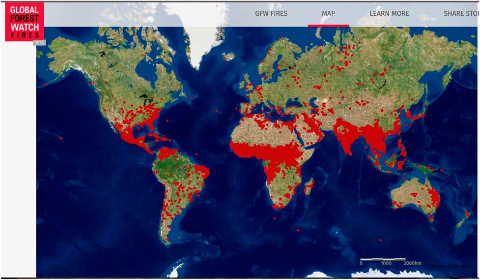
The counterhegemonic potential of the GFW platform is furthermore limited as – notwithstanding its global panoptic character – it ultimately falls back to the dominant geopolitical gaze described in the previous section. This is perfectly illustrated by the GFW Fires application.Footnote 92 This tool adds a data layer that comprises near real-time information on active forest fires generated by NASA’s Visible Infrared Imaging Radiometer Suite sensor, and processed with a fire detection algorithm. As Figure 4 below illustrates, the resulting global map paints the picture of three global forest fire hotspot regions: Central America, East Asia, and sub-Saharan Africa.
Screenshot of three zones of forest fire, visualised by the Global Forest Watch active forest fire data layer. Source: Authors, based on GFW.
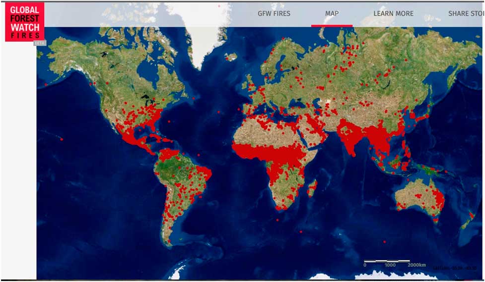
Due to the high spatial resolution of the NASA imagery of 375 meters per pixel it is, however, impossible to further examine the extent, qualities, or source(s) of single fires. Another imagery layer from DigitalGlobe’s First Look service offers a solution, as it ‘provides imagery of burn scars and active fires for ground truthing the NASA Active Fire alerts’.Footnote 93 However, the DigitalGlobe First Look imagery is only available for a single country: Indonesia. The GFW Fires tool allows every person in the world with Internet access to take a closer look at Indonesian territory (at spatial resolutions of 50–60cm),Footnote 94 and to see the wildfire crisis with their own eyes. The tool also includes archived data and maps for any located fire in Indonesia since 2013, as a georeferenced dot on the interactive map.
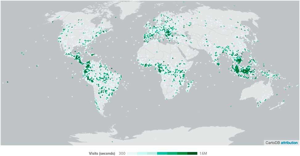
The exclusive focus on Indonesia enabled by DigitalGlobe is another perfect example of the selectivity of the satellite image complex described in the previous chapter. The visual activist gaze allowed by the image complex does not challenge the system of sovereign nation-states per se, but only the sovereignty of some, which are situated in deforestation hotspot regions around the globe. This observation is supported by GFW’s own data on the behaviour of the GFW platform users.Footnote 95 Figure 5 shows the places that GFW users looked at for longer than 300 seconds at high zoom-levels (zoomed in). The darker the green color the longer the users watched these areas. As one can see, the private ‘forest-watchmen’ using the GFW-platform are mainly interested in Central and Eastern Europe, West Africa, and most importantly Southeast Asia and South America. As a more general trend the blog post identifies that ‘boreal forests are not getting as much attention as tropical forests’.
Most-watched areas of the GFW Internet-tool. Source: {http://blog.vizzuality.com/post/129077179181/who-watches-the-global-forest-watchmen} accessed 28 August 2017.
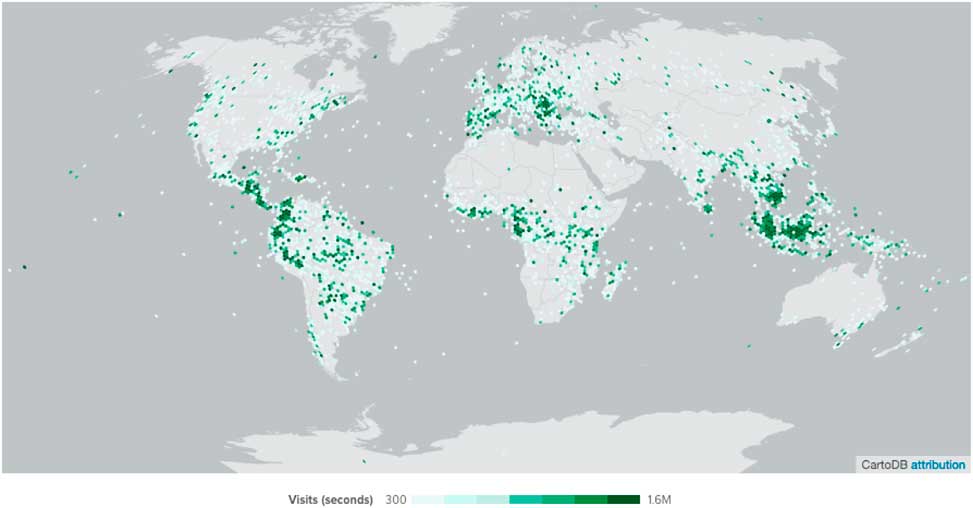
GFW indeed uses satellite data to ‘lift the veil of sovereignty’ and identify processes of deforestation inside of countries. Yet, not all countries are equally targeted as the disclosing gaze is entirely directed as deforestation hot-spot countries such as Indonesia or Brazil. Our point is certainly not to deny that deforestation and illegal wildfires pose a serious problem in Indonesia and elsewhere. However, we hold that the GFW tool thus reproduces a geopolitical gaze creating antagonisms between (forest) crisis regions and the rest of the world thereby downplaying the fact that the problem of forest fires also exists beyond monitored crisis regions. The exclusive focus on deforestation crisis regions and tropical furthermore ties in with particularly prominent, neocolonial ‘degradation narratives’ in Western environmental discourse.Footnote 96 In this narrative, environmental problems in developing countries are ascribed to the unsustainable behaviour of local populations that would – devoid of any environmental conscience – overuse timbre and other natural resources. In the case of deforestation such narratives reduce tropical deforestation to the acts of greedy local actors – illegal loggers in the Amazon, farmers in Indonesia. The global structural conditions that drive these local actors become blurred.Footnote 97 The voyeuristic view on Indonesian people furthermore simplifies their relation with fire – for example by obscuring the fact that the country’s farmers use it as a means of agricultural optimisation.
Conclusion
In this article, we have sought to introduce the debate on satellite-based activism in the field of humanitarian and environmental governance to IR scholarship. Locating our discussion in the context of the growing role of non-state actors, transparency, and authority in global governance, we examined two important fields of satellite-based activism: human rights remote sensing and environmental monitoring.
We studied these fields of satellite activism along the lines of three analytical dimensions. First, we asked for the practices of non-governmental remote sensing. In the cases examined three dominant types of practices could be distinguished: looking, showing, and interacting. Practices of looking include the identification and detection of phenomena such as the destruction of human infrastructures, secret prisons and mass graves, illegal deforestation, and forest wildfires. In particular, the possibility of repeated looking through a time-series of satellite images is deployed as a means of knowledge production – such as in fact-finding missions on war crimes or in the monitoring of deforestation. Non-governmental remote sensing also involves, second, practices of showing images to create certain political effects. Online platforms such as Eyes on Darfur, Satellite Sentinel, or GFW are created to reveal visual evidence of human rights abuses or eco-crimes, and to turn the heads of global publics that become enabled to bear witness to these incidences. Third, the analysed non-governmental remote sensing projects involve practices of interacting with the subjects under surveillance. The interactive platforms of Eyes on Darfur or GFW seek to engage viewers as participating watchmen by, for instance, allowing them to actively scroll through maps, to change visual perspectives, and to modify data resolutions. The interface invites viewers to become ‘quasi-experts’ in investigations of human rights abuses or environmental crimes.
Our second analytical category was forms of visuality produced by non-governmental remote sensing projects. In both fields under scrutiny here, projects revolved around a techno-scientific gaze that promises to provide exact and objective knowledge of observed realities. This promise is based on the perceived neutrality of the technologically mediated view and its possibility to abstract from local meaning subjective – viewpoints. The visuality underlying satellite remote sensing produces a standardised and quantified vision of local space. The processes of image production and interpretation and the myriad range of subjective decisions that they involve become black-boxed. At the same time, the NGO projects studied in this article also draw upon and reproduce a certain geopolitical gaze: a ‘Western’ worldview that is focused on the humanitarian and ecological ‘other’ – namely humanitarian or environmental crisis zones located in the so called ‘Global South’.
Coming to the third category of the power effects and political implications of non-governmental remote sensing, our case studies have shown that the increasing availability and accessibility of high-resolution remote sensing imagery provides non-governmental actors with novel sources of authority. Knowledge is power and ever expanding and advancing remote sensing technology promises an infinite amount of data from around the planet. The authority of non-governmental remote sensing and its promise of creating radical uncertainty is, however, limited by the exclusive and closed nature of the satellite image complex that sustains it. Access to satellite imagery is blocked not only due to security concerns and practices of shutter control but also because of its high price tags and the strong expertise required to process and interpret the images. We found that, rather than challenging statist representations of global order, NGOs are often complicit in helping reproduce a dominant, state-driven satellite gaze and its underlying forms of visuality.
Taken together these findings paint an ambiguous picture of satellite’s counter-hegemonic potential. On the one hand, the studied non-governmental projects provide the broader public with insights into political problems in remote areas that would otherwise remain hidden. They provide individuals with considerable panoptic power and could hence in theory shift the information asymmetries and spheres of authority in global (environmental and humanitarian) governance. On the other hand, this counterhegemonic potential is limited by the techno-scientific and geopolitical gaze that underlies major projects of non-governmental satellite remote sensing as well as the closed nature of the satellite image complex.
As we concentrated on major examples of non-governmental satellite remote sensing we do not claim that our findings apply to all forms of visual activism. Smaller, more radical projects of visual activism – often drawing visual technologies that are more easily accessible than satellite imagery – challenge the dominant statist and non-governmental forms of visuality described in this article.Footnote 98 The further opening and democratisation of satellite technologies (including the development of commercial micro-satellites) might soon provide these more radical visual activists with high-resolution satellite imagery. In the not-too-distant future, the combination of geospatial technologies and advanced machine learning might bring about something like a ‘searchable real-time CCTV of the planet’.Footnote 99 This clearly harbors the dystopian potential for an omnipresent system of state surveillance. At the same time, however, this opens opportunities for new forms of ‘sousveillance’ if counterhegemonic NGOs and activists become able to appropriate such technologies. Hence, further research into the politics of visual activism that compares the application of different technologies and includes more actor types – just as the further training and education of the general public – is needed to increase its ‘visual literacy’Footnote 100 in interpreting and evaluating satellite images.
Acknowledgements
This is a fully co-authored article. Author names appear in alphabetical order. The authors would like to thank the reviewers and Philipp Olbrich for helpful comments on earlier versions of the article.