

Introduction
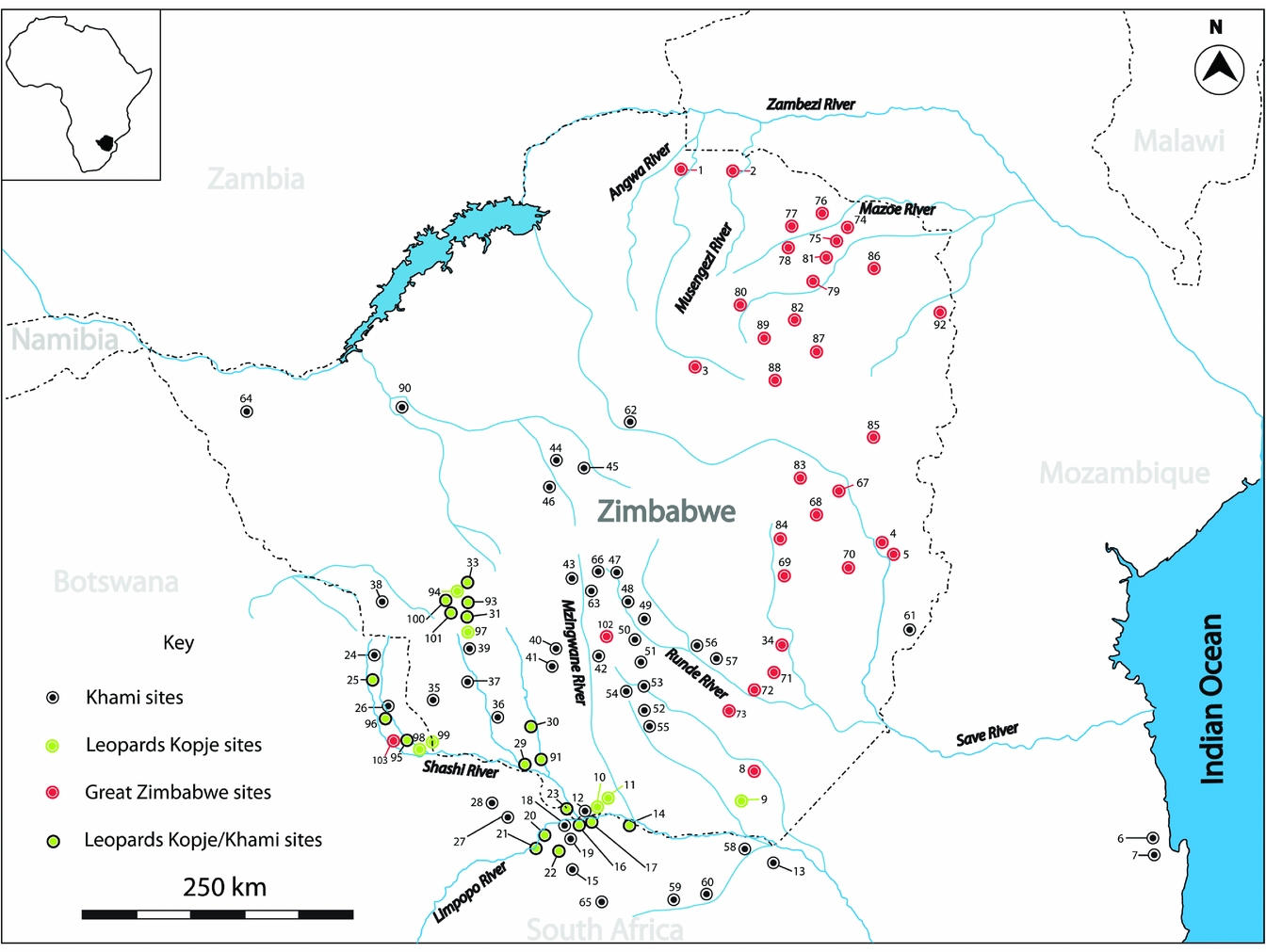
This paper builds on earlier research which established that the evolution of socio-political complexity associated with the Zimbabwe culture was dynamically multi-linear as evidenced by the presence of chronologically overlapping sites with identical cultural attributes across the southern Zambezian landscape (see Chirikure et al. Reference Chirikure, Manyanga, Pikirayi and Pollard2013a; Reference Chirikure, Manyanga, Pollard, Bandama, Mahachi and Pikirayi2014; Reference Chirikure, Bandama, House, Moffett, Mukwende and Pollard2016a). The Zimbabwe culture (ad 900–1900) (Fig. 1) is one of the most prominent and internationally famous complex state systems in southern Africa (Caton-Thompson Reference Caton-Thompson1931; Garlake Reference Garlake1973; Pikirayi Reference Pikirayi2001). Zimbabwe culture sites, characterized most prominently by the presence of dry-stone walled architecture, are found across the Zimbabwean plateau and in the adjacent regions of Botswana, Mozambique and northern South Africa. Great Zimbabwe and Khami (both UNESCO World Heritage sites) are respectively two of the biggest and most prominent Zimbabwe culture sites. Buoyed by an absence of well-resolved chronological data and a lack of comprehensive archaeological work in the wider region for much of the twentieth century, the Zimbabwe culture was traditionally conceptualized as a group of hierarchically organized polities whose political and economic power corresponded to the sizes of individual settlements and the quantity of prestige objects recovered therein (see Caton-Thompson Reference Caton-Thompson1931; Gardner Reference Gardner1963; Garlake Reference Garlake1968; Randall-McIver Reference Randall-MacIver1906; Robinson Reference Robinson1959; Reference Robinson, Summers, Robinson and Whitty1961a; Summers et al. Reference Summers, Robinson and Whitty1961). Until the late 1970s, Great Zimbabwe was viewed as the cradle and capital of an extensive empire that hierarchically controlled related but smaller polities stretching from the Indian Ocean to the Kalahari (Garlake Reference Garlake1973) (see Fig. 1 for distribution of sites).
Location of Great Zimbabwe, Khami, and the approximate distribution of the Zimbabwe culture as represented by dots symbolizing the Great Zimbabwe, Khami and Leopard's Kopje sites: (1) Kasekete; (2) Mutota; (3) Matanda aChiwawa; (4) Ndongo; (5) Charumani 2; (6) Chibuene; (7) Manyikeni; (8) Mwenezi; (9) Malumba; (10) Tshobwane; (11) Mutshilachokwe; (12) Mtao Village 16; (13) Thulamela; (14) Weipe; (15) Machemma; (16) K2; (17) Mapungubwe; (18) Samaria; (19) Faure; (20) Leokwe; (21) Rhodes Drift; (22) JC Hill; (23) Megwe; (24) Domboshaba; (25) Selolwe; (26) Vumba; (27) Lotsane; (28) Thune; (29) Mapela & Little Mapela; (30) Jahunda; (31) Khami; (32) Danamombe; (33) Tabazikamambo; (34) Great Zimbabwe; (35) Impakwe; (36) Makutamazan; (37) Dwala Itche; (38) Mtoli; (39) Fumukwe; (40) Lumene; (41) Mkashi; (42) Rubabvu; (43) Mudnezero; (44) Copper ruins; (45) Vatiswa; (46) Longwe; (47) Nsalansala; (48) Mupopoti; (49) Wedza; (50) Zumnungwe; (51) Mundie 3; (52) Escepwe; (53) Little Chumnungwa; (54) Check Ruin; (55) Dwala Farm 2; (56) Chomuruvuti; (57) Dombo Shoko; (58) Makhahane; (59) Makoleni; (60) Tshaluvimbi; (61) Chikwanda (Webster); (62) Sebakwe; (63) Zinjanja; (64) Bumbuzi; (65) Dzata; (66) Naletale; (67) Muchuchu; (68) Matendera; (69) Musimbira; (70) Chibvumani; (71) Majiri; (72) Pamuuyu; (73) Nenga; (74) Mt Fura; (75) Baranda; (76) Wazi Hill; (77) Zvongombe; (78) Chamagora; (79) Ruanga; (80) Nhunguza; (81) Matanda; (82) Chisvingo; (83) Kagumbudzi; (84) Chirongwa; (85) Harleigh Farm; (86) Tere; (87) Tsindi; (88) Ditcom; (89) Main Farm; (90) Halfway house; (91) Mananzve/Little Halisupi; (92) Matemba; (93) Nali Hill; (94) Mawala Hill; (95) Mupane sites; (96) Tati sites; (97) Matopos sites; (98) Dinokwe; (99) Tholo; (100) Woolandale; (101) Blue Jay/Bunting Close; (102) Nkankezi; (103) Mupanipani.

From the 1960s onwards, increasing research by historians who combined oral sources with Portuguese documents (e.g. Abraham Reference Abraham1959; Beach Reference Beach1998; Mudenge Reference Mudenge1974) suggested that the collapse of Great Zimbabwe (parent) stimulated the rise of two offspring—the Torwa (in the southwest) and Mutapa (in the north) states (Beach Reference Beach1980). In the absence of secure dating evidence and empirical investigation, this event was estimated by archaeologists to fall around ad 1450 (Garlake Reference Garlake1973). Indications from historical sources were often taken by archaeologists as fact without rigorous criticism, and resulting archaeological reconstructions were sometimes uncritically accepted by historians, creating cyclical reasoning (Vansina [1965] Reference Vansina, Dunaway and Baum1996). Currently, it is now well understood that historical and archaeological data must be independently evaluated to develop a nuanced picture of the past.
Huffman (Reference Huffman1982; Reference Huffman1996; Reference Huffman2007) performed a reassessment of available radiocarbon dates and combined cognitive archaeological theory with material culture evidence to argue that the Zimbabwe culture evolved in a linear manner between a series of hierarchically organized states. Mapungubwe (capital and state of the same name) (ad 1220–1290) represented the earliest phase (parent) and was succeeded by Great Zimbabwe (capital and state of the same name) (ad 1300–1450) (daughter/son), whose collapse was followed by the rise of the Torwa state centred at Khami (ad 1450–1650) (granddaughter/grandson) and the Mutapa state (ad 1450–1900) (granddaughter/grandson), the latter two coterminous (see Chirikure et al. Reference Chirikure, Manyanga, Pollard, Bandama, Mahachi and Pikirayi2014 for critique). Within this linear evolutionary hierarchy, each state capital was supported by a fixed hierarchy of control measured by decreasing settlement size which corresponded to the provincial, district and village levels of social organization (Huffman Reference Huffman2007). Furthermore, it was argued (Huffman Reference Huffman1981; Reference Huffman1996) that the continuity in the use of space between earlier and later Zimbabwe culture capitals reflected the continuity of a settlement pattern reflective of a class-based hierarchy and an ideology of sacred leadership (see Beach Reference Beach1998; Collett et al. Reference Collett, Vines and Hughes1992; Lane Reference Lane1994/5; 2005, for criticism; and Huffman Reference Huffman2000; Reference Huffman2007, for response).
Without doubt, previous work has greatly advanced our understanding of the Zimbabwe culture (e.g. Denbow et al. Reference Denbow, Smith, Ndobochani, Atwood and Miller2008; Gardner Reference Gardner1963; Garlake Reference Garlake1970; Huffman Reference Huffman2007; Pikirayi Reference Pikirayi2001; Pwiti Reference Pwiti1996; Robinson Reference Robinson1959; Sinclair et al. Reference Sinclair, Pikirayi, Pwiti, Soper, Shaw, Sinclair, Andah and Okpoko1993; van Waarden Reference van Waarden2012). However, to date, few archaeologists have sought critically to evaluate the vertical and horizontal relationships between former capitals of different Zimbabwe culture polities. For example, it is not clear whether the suggestions from oral historical observations that the collapse of Great Zimbabwe gave rise to Khami can withstand detailed archaeological scrutiny. Emerging work in northeastern Botswana (van Waarden Reference van Waarden2011; Reference van Waarden2012) is highlighting similarities and strong stratigraphic succession between earlier (pre-ad 1400) Leopard's Kopje sites and the later (post- ad 1400) Khami sites. This observation potentially indicates that Khami has a historical derivation from earlier societies in this region, prompting van Waarden (Reference van Waarden2012) to conclude that it is unlikely Khami evolved out of Great Zimbabwe. Equally, Pwiti (Reference Pwiti1996) observed that some stone-walled sites that may be former Mutapa capitals in northern Zimbabwe (e.g. Zvongombe) appear to have been well established before Great Zimbabwe's alleged mid fifteenth-century collapse. At the same time, new dates from poorly researched areas of Great Zimbabwe indicate that the site flourished into the seventeenth and perhaps eighteenth centuries (see Summers et al. Reference Summers, Robinson and Whitty1961, for initial argument; and Chirikure et al. Reference Chirikure, Bandama, House, Moffett, Mukwende and Pollard2016a, for new dates). Furthermore, that Mapungubwe is the sole cradle of the Zimbabwe culture has been challenged (see van Waarden Reference van Waarden2012). These observations indicate the possibility of multiple, independently formed and chronologically overlapping state-like structures across the Zimbabwe plateau from the early through to the late second millennium ad.
Based on insights emanating from a long-term and ongoing engagement with the archaeology of Khami (see Chirikure et al. Reference Chirikure, Pikirayi, Pwiti, Chami and Pwiti2001; Mukwende Reference Mukwende2016) and Great Zimbabwe (e.g. Chirikure & Pikirayi Reference Chirikure and Pikirayi2008; Chirikure et al. Reference Chirikure, Bandama, Chipunza, Mahachi, Matenga, Mupira and Ndoro2016b) and a critical review of the historical record of southern Zambezia, this paper exploits the analytical potential offered by a framework of heterarchy to explore the relationships between Khami and Great Zimbabwe. It shows that local ceramics from the two sites are different across their entire occupation sequences and their stylistic attributes indicate a different evolutionary genesis and trajectory. Furthermore, there are visible typological differences between and within their related dry-stone architecture. Added to this, absolute and relative chronologies of the two sites point to significant overlaps suggestive of co-existence of the polities which they represent. Comparative insights from Shona political anthropology indicate that inter-polity relationships were heterarchical, while intra-polity relationships were malleably hierarchical, albeit with some elements of heterarchy (see Beach Reference Beach1994; Chirikure & Pikirayi Reference Chirikure and Pikirayi2008; Chirikure et al. Reference Chirikure, Manyanga and Pollard2012; Lan Reference Lan1987; Sinclair et al. Reference Sinclair, Pikirayi, Pwiti, Soper, Shaw, Sinclair, Andah and Okpoko1993; Weinrich Reference Weinrich1971).
Concepts: Shona rotational political succession, intra-polity hierarchy and inter-polity heterarchy
One of the most interesting cultural behaviours, and yet archaeologically slippery concepts, associated with historical (c. 1500 to 1900) political formations in southern Zambezia is that of rotational political succession, sometimes known as collateral succession (see Beach Reference Beach1980; Chirikure et al. Reference Chirikure, Manyanga and Pollard2012; Reference Chirikure, Bandama, House, Moffett, Mukwende and Pollard2016a; Holleman Reference Holleman1952; Sinclair et al. Reference Sinclair, Pikirayi, Pwiti, Soper, Shaw, Sinclair, Andah and Okpoko1993). In historical/archaeological Shona states such as Mutapa (Lan Reference Lan1987; Pikirayi Reference Pikirayi1993) and Torwa (Beach Reference Beach1994), political succession followed the system of ‘houses’, which were basically lineages that descended from the founders of specific political entities. Available historical information makes it explicit that, from the early sixteenth century onwards, Mutapa kings were selected from the descendants of Nyatsimba Mutota, the founder of the state (Lan Reference Lan1987; Mudenge Reference Mudenge1988). Nyatsimba Mutota had many sons, each of whom was given a district to rule in the state. The lineages of these sons, over time, became houses of power (dzimba dzoushe in Shona: see Chirikure et al. Reference Chirikure, Manyanga and Pollard2012), from which future kings, provincial and district leaders were and are still being drawn. Upon the death of the founder, political succession rotated around these ‘houses’, starting from that of the first son to that of the youngest. Furthermore, spirit mediums associated with deceased kings or chiefs (mhondoro) played an important role in royal inauguration, national prayer, dethroning a cruel leader and, among others, communicating with Mwari [God] via ancestors (Lan Reference Lan1987). The power of chiefs or kings was counterpoised by that of spirit mediums. Not surprising, within a hierarchy of Mutapa spirit mediums, Mutota ranks highly (Lan Reference Lan1987).
Under this succession system, rotation implied that, when a new leader ascended the throne, they did not move into the homestead of their predecessor (see Chirikure et al. Reference Chirikure, Manyanga and Pollard2012). Instead, they ruled from their own home, which became the centre of power. This means that capitals within the state shifted, and that the status of units such as provinces and districts changed depending on the political alignment of the day. The level of control effected by the centre varied from weak to strong, such that there are historically known examples of districts that were more powerful than the centre (see Mudenge Reference Mudenge1988). In practice, this principle of political succession was sometimes short-circuited through military coups and deaths and in cases where rightful successors might not have left offspring. However, an understanding of Mutapa history and archaeology suggests that, in most cases, the principle was that no king ruled from the centre of their predecessor.
The materialization of this practice is evident from Beach (Reference Beach1994), whose work on Shona political dynasties indicated that the centres of the Mutapa state shifted between the plateau and the adjacent lowlands following power shifts between different lineages or houses of power. Archaeological work by Pwiti (Reference Pwiti1996) and Pikirayi (Reference Pikirayi1993) identified former capitals in former Mutapa Districts in the mid-Zambezi valley (Guruve and Muzarabani) (e.g. Mutota's Zimbabwe, Rusvingo wa Kasekete, Matanda aChiwawa, etc.) and on the plateau (Centenary and Mt Darwin areas) (e.g. Matope, Ngome and Nowedza). Mutota's Zimbabwe is believed to be Nyatsimba Mutota, the founder of the state's seat of power (Mudenge Reference Mudenge1988). At present, the districts and chieftainships such as Chitsungo, Chiwawa, Matope, Rusambo and many more in northern Zimbabwe are all associated with Mutapa lineages (Beach Reference Beach1994). The expectation is that more archaeological research may identify evidence of this practice on the ground. In this context, and given variation in the success of individual leaders, scalar hierarchies based on using differences in settlement size to identify hierarchies of control are inappropriate.
The principles attested in the Mutapa state were also expressed in the chronologically overlapping, but southwestern Zimbabwe/northeastern Botswana-based Torwa-Changamire polity. Empirical evidence suggests that the seat of Torwa-Changamire power moved from Khami to Danamombe and possibly to other places before ending up at Tabazikamambo, the last known capital in the nineteenth century. In the process, hierarchies of control were also malleable. Historical evidence suggests that dry-stone walls in and around the Zimbabwean Midlands are associated with different ruling lineages. What is interesting is that, despite shifts in power, occupation often continued at some places. For example, Danamombe has yielded apple-green Ming Dynasty Chinese porcelain dating to the late fourteenth/early fifteenth centuries, which has so far not yet been found at Khami. Such porcelain is, however, known from Great Zimbabwe. Furthermore, Tabazikamambo has a successive sequence of occupation from the Leopard's Kopje through to the late Khami period.
While the principles governing the functioning of individual polities were culturally similar, including the counterpoising role of spirit mediums (see Mudenge Reference Mudenge1974), the most important question is how did they relate to each other? Although not much information is available, some sources suggest that the inhabitants of the state based at Khami were known as Torwa (NB torwa is Shona for unrelated people, plural: vatorwa) by those at Great Zimbabwe and the Mutapa state (Pikirayi Reference Pikirayi2001). The Changamire Dynasty (also known as Rozvi) based at Danamombe and other places was autonomous and there is no suggestion of a hierarchical relationship with either Mutapa or Great Zimbabwe (see Mudenge Reference Mudenge1988). While each ruling lineage (of a polity) controlled territory known as nyika, boundaries were demarcated by physical features, such as rivers and hills. In his mapping of historically known Shona dynasties, Beach (Reference Beach1994) identified many Shona dynasties (and polities) which shared borders and co-existed on the landscape. Often, there was no relationship of seniority between polities and inter-marriages, and differential specialization sometimes brought responsibilities that counterpoised power relations between polities.
Adding a layer of linguistic evidence, Chimhundu (Reference Chimhundu1992) argued that the concept of the state conventionally utilized in archaeological models of the Zimbabwe culture, as a highly centralized and territorially expansive entity, sounds more of an exception than a rule. Using the history of words and places, he suggested that often many states had an average territorial size falling within a 50 to 100 km radius. This makes it likely that the Portuguese often exaggerated the power and size of polities such as the Mutapa and Torwa-Changamire states for political grandstanding in Portugal.
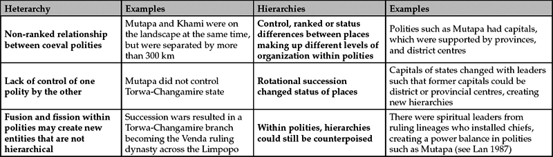
Clearly, the Shona political process combined elements of context-mediated heterarchies and situational hierarchies, all of which differentially left imprints on the landscape. These are summarized in Table 1.
Elements of inter-polity heterarchy and intra-polity hierarchies amongst the Shona.

A critical evaluation of Table 1 shows that inter-polity heterarchies and intra-polity hierarchies were not mutually exclusive behaviours; they speak to different scales of political organization within and between Shona polities. However, identifying these behaviours archaeologically may be hindered by several challenges which demand careful, recursive and multi-scalar analysis. For example, at the inter-polity scale, some centres of power might have been of different sizes, which might promote inappropriate inferences about the boundaries and authority which different polities may or may not have possessed (see Beach 1984). Thus, the traditional thinking that Great Zimbabwe was the capital of a territorial state stretching from the Indian Ocean coast to the Kalahari Desert was partly based on the logic of settlement sizes. However, it is now known that, though powerful, Great Zimbabwe's influence was limited (see Chimhundu Reference Chimhundu1992). At intra-polity level, it is difficult to estimate the duration of the reign of different rulers, given that some settlements were occupied before and after they got power.
This is especially important in the case of Danamombe, which was occupied when Khami was the centre, became a centre itself and passed on power to other places, but nevertheless continued to be occupied. Furthermore, shifting capitals created fluid hierarchies of control which may be archaeologically elusive. For example, what was the nature of within-polity hierarchy when Mutota was the capital of the Mutapa state, and when power moved to another place? Lastly, the resolution of chronometric methods of dating, such as the radiocarbon technique, is not sufficiently fine textured to tease apart events of short-term duration (such as length of a king's reign) from long-term duration events (such as the overall length of occupation at a given site) (see Chirikure et al. Reference Chirikure, Manyanga and Pollard2012 for detailed discussion). Rather than being limitations, these challenges highlight that the concepts of heterarchy and hierarchy (which can be considered power strategies) as summarised in Table 1 were characterized by fluidity and malleability to the extent that associated behavioural outcomes were continually reordered across time and space. Understanding these principles may empower archaeologists to explain more variability in the past.
Regardless of issues of scale, the existence of archaeological sites equivalent to centres of power at widely separated distances (more than 100 km, as suggested by Chimhundu Reference Chimhundu1992) can be used as a proxy for autonomous archaeological states. This is the same logic used by Beach (1984) to model the boundaries of some pre-colonial states in southern Zambezia. Thus, within a well-resolved chronological framework, it is possible that the distances between some of the well-known stone-walled sites such as Great Zimbabwe, Kubiku, Majiri, Mapungubwe, Mapela, Gombe and many others (see Fig. 1) were centres of independent polities (see Beach 1984). However, researchers must be alert to the fact that often boundaries of states shifted like those of the Mutapa state, which rotated between the Zambezi lowlands and different areas of the plateau, depending on the location of the ruler. It is essential to apply some of these ideas to the archaeology. The next section presents archaeological evidence from the separate entities of Great Zimbabwe and Khami.
The archaeology of Khami and Great Zimbabwe
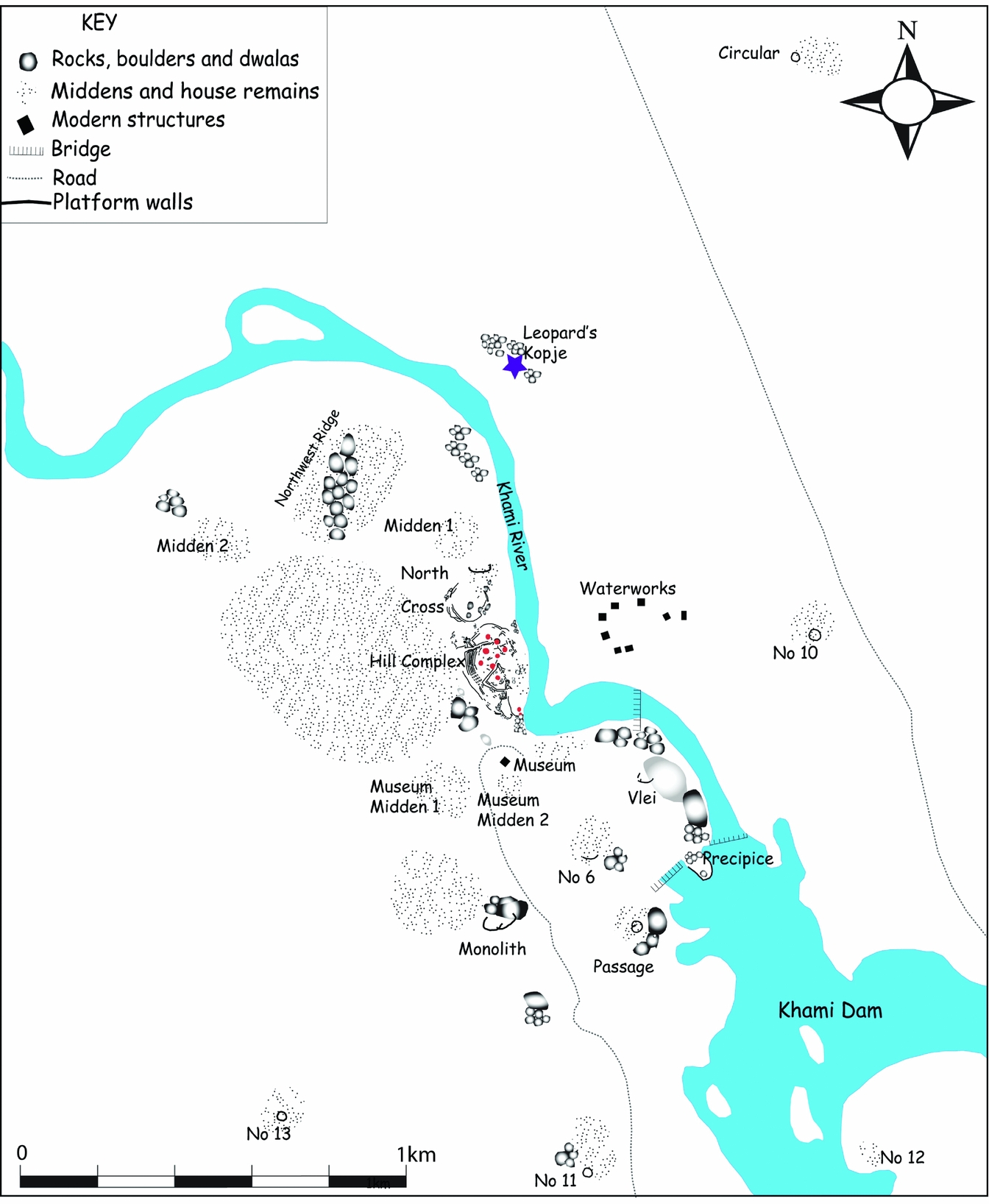
Located 22 km west of Bulawayo and spread over 200 ha, Khami (Fig. 2) is comprised of 14 dry-stone walled platforms and surrounding unwalled areas. In some cases, the platforms had only a few houses, but were surrounded by more houses on the flats. However, the spatial relationships between platforms and surrounding houses require more investigation. Until now, scholars unquestioningly accepted that Khami, the capital of the Butua state, was founded by the Torwa, a sub-group of Shona people, after the demise of Great Zimbabwe, around ad 1450 (Beach Reference Beach1980; Huffman Reference Huffman2007; Pikirayi Reference Pikirayi2001). This gave birth to the view that the relationship between the two sites was that of parent and offspring.
Site plan of Khami showing dry-stone walled platforms and surrounding unwalled settlements.

To date, the most comprehensive work ever performed at Khami was that by Robinson (Reference Robinson1959). This work focused mostly on walled areas such as the Hill Complex, the Passage and, among others, the Vlei Platforms. Robinson also excavated unwalled settlements within the vicinity of the Hill Complex and at Leopard's Kopje, about 2 km from the former. Little work was, however, performed on middens that surround platforms at Khami, some of which seem to be associated with houses on the flats (see, for example, Midden 2 on Figure 2). Other scholars (e.g. Thorp Reference Thorp1995 and Hughes Reference Hughes1997) also worked on the site, but in spaces closely tied to the walled areas. To develop an understanding of the sequence of occupation in unwalled areas, excavations were performed at Midden 1, Midden 2 and among others Museum Midden areas (see Figure 2 and Mukwende Reference Mukwende2016 for details). The intention was also to obtain additional radiocarbon dates for the site. Our study combined artefacts from our excavations with those from legacy collections in the museums in Harare and Bulawayo.
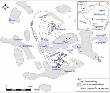
Great Zimbabwe is spread over 720 ha, and is comprised of clusters of dry-stone walled enclosures, surrounded by unwalled settlements (Fig. 3). Although various researchers have worked on the site (e.g. Caton-Thompson Reference Caton-Thompson1931; Randall-McIver Reference Randall-MacIver1906), the excavations by Summers et al. (Reference Summers, Robinson and Whitty1961) on the Hill Complex and the Great Enclosure have generated most of the material that has contributed to our understanding of the site. However, as with Khami, little is known about the unwalled areas of Great Zimbabwe. Part of our work at Great Zimbabwe targeted such areas (see Chirikure et al. Reference Chirikure, Bandama, House, Moffett, Mukwende and Pollard2016a,b,c).
Great Zimbabwe, showing the different areas making up the site. (Map originally published in Chirikure et al. Reference Chirikure, Bandama, House, Moffett, Mukwende and Pollard2016a.)

Stone walling from Khami and Great Zimbabwe
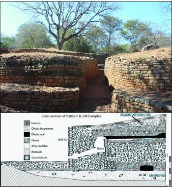
Both Khami and Great Zimbabwe are well known for their contrasting dry-stone walls (Figs 4 & 5). As shown in Figures 2 and 4, Khami is dominated by magnificent retaining walls that created platforms such as the Hill Complex, the Precipice Platform and, among others, the Monolith Platform. The retaining walls were built without any binder. Their construction involved neatly packing a core of stones abutting the platform and building very neatly coursed and dressed outer walls (Fig 4; Robinson Reference Robinson1959, 81). These platforms resemble, in both construction technique and appearance, the Leopard's Kopje walling in southwestern Zimbabwe, the Shashi-Limpopo portion of northern South Africa and northeastern Botswana (Chirikure et al. Reference Chirikure, Manyanga, Pikirayi and Pollard2013a; Robinson Reference Robinson1965; 1985; van Waarden Reference van Waarden2011; Reference van Waarden2012).
(Above) The exposed Passage platform at Khami Enclosure (photograph: Tawanda Mukwende); (Below) Re-drawing of a section of the wall on Platform B, Khami Hill Complex (redrawn from Robinson Reference Robinson1959, 81.)

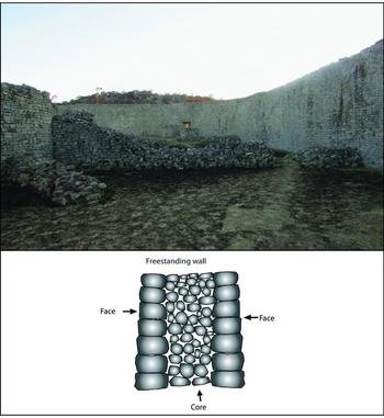
(Above) The enclosing free-standing walls making up the outer curtain wall of the Great Enclosure (photograph: Robert T. Nyamushosho); (below) A schematic representation of how the walls were structured, with two neatly dressed outer faces and an inner core (redrawn after Ndoro Reference Ndoro2005, 23.)

Unlike Khami, Great Zimbabwe is comprised of freestanding walls that make up enclosures where houses were built (Fig. 5). Freestanding walls have two outer faces of neatly dressed stones with a core stacked in the middle. Whitty (Reference Whitty, Summers, Robinson and Whitty1961) developed an architectural sequence of dry-stone walls at the site: P or poorly coursed walls are the earliest, followed by the intermediate PQ, which had a mix of poor and good coursing. Q walling, which represents the most neatly coursed wall type built of regular sized blocks, followed. Roughly coursed walls (Type R) constituted the last type. According to Whitty (Reference Whitty, Summers, Robinson and Whitty1961), the construction of walling at Great Zimbabwe started on the Hill Complex and spread to the Great Enclosure areas with P and PQ walling. The parts of the site which are exclusively built in Q style, such as the Lower Valley and East Enclosures, were built much later, indicating that the site expanded with time (Collett et al. Reference Collett, Vines and Hughes1992).
When compared to Great Zimbabwe, no wall classification has been performed to understand the typology of the walls at Khami. The thinking was that because Khami evolved out of Great Zimbabwe, it had only Q-type walls. However, sections of the lower walls on parts of the Hill Complex display a construction style that can easily be classified as R. Garlake (Reference Garlake1970), however, observed that the practice of building dry-stone platforms was a feature of earlier Leopard's Kopje and later Khami sites in southwestern Zimbabwe, northeastern Botswana and adjacent areas of northern South Africa. For example, Leopard's Kopje walls at Mapungubwe, Mapela, Nyangabgwe, Selolwe and many others (see Fig. 1) in construction style and technique resembled Khami platforms. Khami appears to be a continuation of earlier Leopard's Kopje walling (van Waarden Reference van Waarden2012).
As far as the sequence of walling is concerned, the earliest walling at Great Zimbabwe appeared around ad 1000 (Chipunza Reference Chipunza1994; Summers et al. Reference Summers, Robinson and Whitty1961). However, Khami is poorly dated, such that the earliest walls at the site are not only unknown, but are also undated. However, platforms like those of Khami were built by Leopard's Kopje peoples around the late first/early second millennium ad. It is probable, based on architectural similarities, that these Leopard's Kopje platforms evolved into the Khami types, just as the P walls at Great Zimbabwe flourished into the later Q type. This thinking is given more support by the observation that Leopard's Kopje and Khami platforms display an ideology that exposes the houses of the occupants (Pikirayi Reference Pikirayi2013). This sharply contrasts with the enclosing freestanding walls making up architectural ensembles such as the Western Enclosure on the Hill at Great Zimbabwe, and the Great Enclosure. While more work is required to date the walls at Khami, the evidence indicates a separate ideological motivation and genesis when compared to Great Zimbabwe (Pikirayi Reference Pikirayi2013).
Local ceramics from Khami and Great Zimbabwe
Although problematic and highly controversial (see Mitchell Reference Mitchell2002; Pikirayi Reference Pikirayi2007), the thinking that ceramic decorative style is a proxy for group identity corresponding to ancestors of modern Bantu populations is deeply entrenched in southern Africa. The principal architect of this assumption is Huffman (Reference Huffman2007), who has argued that, from the early second millennium ad, sub-groups of people now known as Shona (e.g. Zezuru, Ndau, Korekore, etc.) can be teased apart using ceramic decorative style. For instance, the Leopard's Kopje was linked to Kalanga speakers, while Gumanye, represented by Period 2 ceramics at Great Zimbabwe (see below), was associated with Karanga speakers. This was supported by a multi-dimensional approach to ceramic style that combined the trinity of vessel shape, decoration technique and placement, and decoration motifs (Huffman Reference Huffman2007).
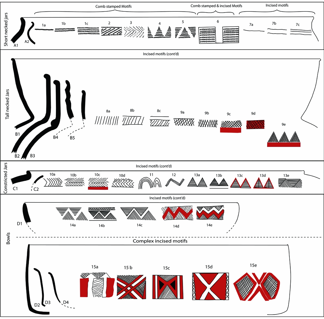
To allow for comparability of results across authors (e.g. Robinson Reference Robinson1959; Chirikure et al. Reference Chirikure, Pikirayi, Pwiti, Chami and Pwiti2001), we re-studied the local ceramics from Khami and Great Zimbabwe, both in the legacy collections and from our recent work, using Huffman's approach. The main outcome was that, as is already known (e.g. Robinson Reference Robinson1959), Khami pottery is associated with a very high frequency of complex decorative designs formed by incisions, comb stamping, moulding and punctation. These techniques formed variable motif combinations that include bands and panels of upward- and downward-facing triangles, horizontal lines of incisions coloured with red ochre, herringbone patterns formed by incisions or punctation, and diamond patterns filled with cross-hatching. The vessel profiles represented at Khami include short-necked pots, tall necked pots, constricted jars and bowls (see Fig. 6). Besides these Khami ceramics, Leopard's Kopje (Mambo phase, ad 1000–1200) pottery was recovered below a cattle kraal immediately east of the Cross Ruin on the Hill Complex (represented by motif 11 and 12: Fig. 6).
Profiles, motif combinations and decoration placement for vessels from Khami (based on Robinson Reference Robinson1959, Chirikure et al. Reference Chirikure, Pikirayi, Pwiti, Chami and Pwiti2001, and our excavation assemblages). Profiles: (A1) Vertical neck; (A2) Concave neck; (B1) Recurved and flared neck; (B2) Vertical neck; (B3) Vertical beaded neck; (B4) Fluted neck; (B5) Recurved neck; (C1) Lipped; (C2) No-lip; (D1) Shallow bowl; (D2) Beaker-bowl; (D3) Beaker-bowl with flared lip; (D4) Flared bowl. Motif combinations and decoration placement: (1a) Single horizontal line; (1b) Double horizontal lines; (1c) Multiple horizontal lines; (2) Horizontal band of oblique and horizontal lines; (3) Horizontal band of herringbone; (4) Horizontal band of triangles; (5) Horizontal band of interlocking triangles; (6) Vertical and horizontal bands; (7a) Single horizontal line; (7b) Double horizontal lines; (7c) Multiple horizontal lines; (8a) Horizontal band of oblique lines; (8b) Horizontal band of oblique lines in horizontal lines; (8c) Horizontal band of oblique lines in double horizontal line; (9a) Horizontal band of cross-hatching with a horizontal line; (9b) Horizontal band of cross-hatching with horizontal lines; (9c) Horizontal band of cross-hatching with colour; (9d) Horizontal band of cross-hatching with horizontal lines and colour; (9e) Horizontal band of cross-hatched triangles with colour; (10a) Horizontal band of herringbone pattern; (10b) Horizontal band of herringbone with a strike-through; (10c) Horizontal band of herringbone with strike-through and colour; (10d) Horizontal band of double herringbone pattern; (11) Multiple wavy lines; (12) Multiple zig-zag lines; (13a) Horizontal bands of triangles; (13b) Horizontal bands of triangles with a horizontal line; (13c) Horizontal bands of triangles with colour; (13d) Horizontal bands of triangles with a vertical strike-through; (13e) Horizontal bands of interlocking triangles; (14a) Horizontal band of unspaced interlocking triangles that are not bound; (14b) Horizontal band of spaced interlocking triangles that are not bound; (14c) Horizontal band of spaced interlocking triangles with horizontal and cross-hatched bands; (14d) Horizontal band of interlocking triangles spaced with colour; (14e) Horizontal bands of interlocking spaced triangles with wavy line and colour; (15a–e) Complex bands of incised motifs. NB Motifs 11 and 12 and the associated shape profile are part of Mambo (first phase of the Leopard's Kopje).

Comparing the frequency of vessel shapes and decoration techniques and motifs by area was an essential analytical process. However, it must be pointed out that some of the legacy collections from Robinson (Reference Robinson1959) do not have stratigraphic details, because they were collected from house floors. However, material from our own excavations could be stratigraphically ordered (see Mukwende Reference Mukwende2016 for excavation reports). The ceramics from the Midden 1, Midden 2 and Museum Midden excavations demonstrated a mixture of all profiles presented in Figure 6, across the stratigraphic sequence (but no Mambo pottery was recovered). A comparison with the Hill Complex pottery from the legacy collections showed a remarkable degree of similarity across the site. Thus, regardless of area, it appears as if the shapes and decoration techniques and motifs were similar across the site. We must also emphasisze that Leopard's Kopje (Mambo) pottery was only encountered in trenches placed in front of the Cross Ruin.
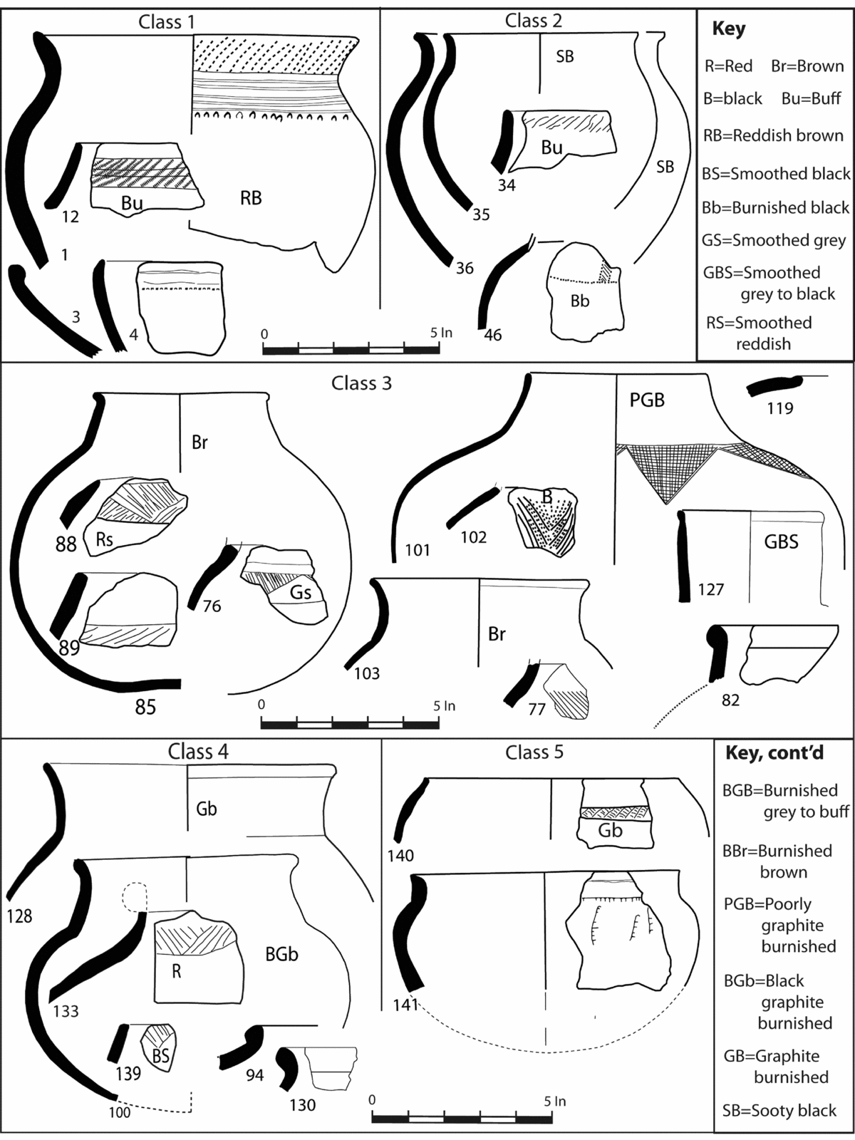
Turning to Great Zimbabwe, a more in-depth stratigraphic analysis of the pottery, mostly from the walled areas, is already available. Robinson (Reference Robinson, Summers, Robinson and Whitty1961b) established five pottery classes consistent with five major periods of occupation as follows: Pottery Class 1 (Period I: ad 300–900); Pottery Class 2 (Period II: ad 900–1000); Pottery Class 3 (Period III: ad 1000–1200); Pottery Class 4 (Period IV: ad 1200–1700); and Pottery Class 5 (Period V: Class 5) (Post- ad 1700) (see also Chirikure et al. Reference Chirikure, Pollard, Manyanga and Bandama2013b; Reference Chirikure, Bandama, Moffett, House, Nyamushosho and Manyanga2016c; Huffman & Vogel Reference Huffman and Vogel1991) (see Fig 7). It is generally accepted that Periods II–V (Pottery Classes 2–5) are associated in one way or another with the builders and users of the stone walls.
Classes 1–5 pottery from Great Zimbabwe (redrawn with original numbering from Robinson Reference Robinson, Summers, Robinson and Whitty1961b, 199–211). Note the differences from Khami (Fig. 6).

Our analysis of the pottery from Great Zimbabwe focused on the legacy material from Robinson's excavation on the Hill, Summers’ excavation in the Great Enclosure, Collett and colleagues’ excavation in the Valley Enclosures and our own excavations in the unwalled areas on the eastern and western sides of the site (see Chirikure et al. Reference Chirikure, Bandama, Moffett, House, Nyamushosho and Manyanga2016c for details). While there was a high degree of vessel fragmentation, the decoration techniques of incisions, comb stamping and occasional punctates dominated. Most of the pots, however, are lavishly graphite burnished, but undecorated (Chirikure et al. Reference Chirikure, Pollard, Manyanga and Bandama2013b; Robinson Reference Robinson, Summers, Robinson and Whitty1961b; Summers et al. Reference Summers, Robinson and Whitty1961). The vessel shapes are dominated by short-necked pots, shouldered pots and tall necked vessels.
As far as the stratigraphic and spatial distribution of pottery types is concerned, Classes 1 and 2 ceramics are limited to the Hill, while Class 3 is concentrated on the Hill but with a presence in restricted areas of the Valley and Great Enclosures that have Period III deposits. Class 4 covers a large part of the site and extends to most unwalled areas to the east and west of the site. Our excavations (see Fig. 3) at the back of the Eastern Area, adjacent to a feature known as Mujejeje, only found Class 4 pottery in a 60 cm deposit. Other excavations at the back of the Great Enclosure and around the modern car park also yielded only Class 4 pottery. Some of the areas that we targeted outside the walls were previously classified as Period V areas (see Sinclair et al. Reference Sinclair, Pikirayi, Pwiti, Soper, Shaw, Sinclair, Andah and Okpoko1993). However, the expectation of finding Class 5 pottery was not fulfilled. This means that the presence of Class 5 pottery at Great Zimbabwe requires further investigation.
A detailed critique of Figures 6 and 7 shows massive differences between ceramics from Khami and Great Zimbabwe. Class 4 ceramics dominate the terminal levels at Great Zimbabwe. These are rarely decorated, but are lavishly graphite burnished with a dominance of shouldered pots and short-necked jars. By comparison, the ceramics from the basal layers of Khami are lavishly decorated with bands and panels of red ochre and graphite burnishing. Constricted pots with thickened rims and tall necked vessels with lavish designs also appear throughout the sequence at Khami. Based on the very large stylistic distance between Khami and Great Zimbabwe pottery, it is highly improbable that ceramics from the former evolved out of the latter.
Comparing the sequence of Khami and Great Zimbabwe: absolute and relative methods
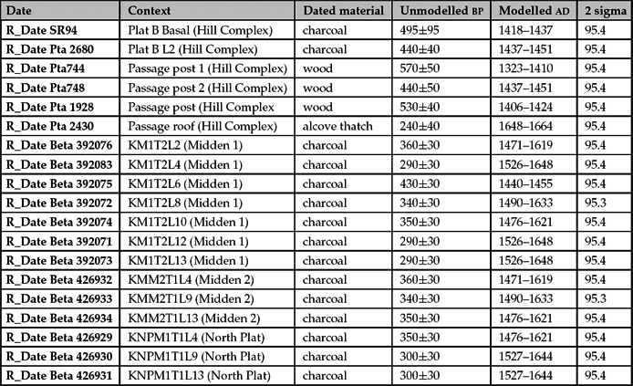
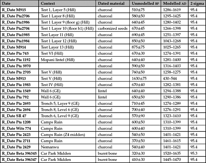
The major categories of material culture—stone walling and ceramics—which define Khami and Great Zimbabwe archaeologically have exposed highly significant differences between the two sites. This directs the spotlight to the chronology of the sites. From the outset, however, it must be acknowledged that both Khami (Table 2) and Great Zimbabwe (Table 3) have very few radiocarbon dates relative to their sizes, making the dates only suggestive but not conclusive.
Radiocarbon dates from Khami calibrated with OxCal version 4.3.1 using the southern Hemisphere Curve (Hogg et al. Reference Hogg, Hua and Blackwell2013).

Radiocarbon dates from Great Zimbabwe calibrated with OxCal version 4.3.1 using the southern Hemisphere Curve (Hogg et al. Reference Hogg, Hua and Blackwell2013).

Table 2 presents the radiocarbon dates from Khami and indicates that the dated parts of the unwalled and walled areas cluster between the late fourteenth/early fifteenth to the mid seventeenth centuries ad.
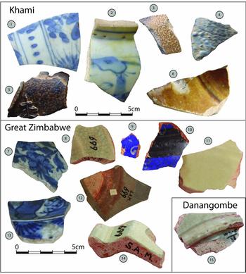
This limited absolute chronology corresponds in part with that implied by the presence of historically dateable imports, such as glass beads and imported ceramics. The glass beads from Khami show an evolutionary trajectory that progressed from K2 and Mapungubwe beads in the basal levels (see Robinson Reference Robinson1959) to Great Zimbabwe and Khami beads in upper levels (see Wood Reference Wood2005; Reference Wood2011, for classification scheme). The imported ceramics also suggest a relative date of the fifteenth to seventeenth centuries (Fig 8).
Imported ceramics from Khami, Great Zimbabwe and Danangombe: (1, 2, 7, 13) Blue-on-white ceramics of the Ming Dynasty (1368–1644 ad); (3, 5) German salt-glazed stoneware (sixteenth century); (4) Portuguese faience (first half of the seventeenth century); (6) Unidentified glazed ceramic; (8, 11, 12, 14, 15) Celadon from the Yuan/Early Ming Dynasties (1279–1368 ad); (9, 10) Islamic frit (from the thirteenth century onwards).

Shifting to the chronology of Great Zimbabwe, the picture that emerges is that of a settlement that expanded with time, beginning from the Hill Complex to beyond the walls outside the valleys. Table 3 suggests that these developments can be placed between ad 1000 and 1700.
An analysis of glass beads from Great Zimbabwe indicates that the site has yielded K2, Mapungubwe, Great Zimbabwe and Khami types of glass beads (see also Robinson Reference Robinson, Summers, Robinson and Whitty1961c). Imported ceramics from Great Zimbabwe are characterized by Islamic ceramics, Chinese celadon and late Ming Dynasty porcelain (see Figure 8). Put together, relative dates implied by the presence of these imports overlap with the absolute chronology.
Existing chronological information, although limited, indicates that Great Zimbabwe and Khami overlap significantly. Within an overlapping chronological framework, and in relation to Shona political processes, what are the implications of the differences in ceramics and walling between these two sites? This is the focus of the discussion section.
Discussion: parent-offspring relationship or inter-polity heterarchy?
Traditionally, and using historical information supplemented by limited archaeological data, the relationship between Great Zimbabwe and Khami has largely been viewed as that of distinct, but successive, political, cultural and economic centres (see Beach Reference Beach1980; Garlake Reference Garlake1973; Huffman Reference Huffman1996; Mudenge Reference Mudenge1988; Pikirayi Reference Pikirayi2001). However, continuing work on unwalled settlements at Great Zimbabwe suggests that neither did it collapse around ad 1450, nor did its influence wane immediately afterwards. This was known since Summers et al. (Reference Summers, Robinson and Whitty1961) and was re-affirmed after significant work in the Valley Enclosures by Collett et al. (Reference Collett, Vines and Hughes1992). New dates from the modern car park area are suggesting terminal dates from the mid seventeenth century for the site (Chirikure et al. Reference Chirikure, Bandama, House, Moffett, Mukwende and Pollard2016a,c).
Oft-cited oral historical sources (see Beach Reference Beach1980; Mudenge Reference Mudenge1988; Pikirayi Reference Pikirayi2001) seem to suggest that the inhabitants of Khami were referred to as the Torwa people by residents of areas around the Mutapa and Great Zimbabwe states. Metaphorically and literally, this seems to suggest lineage differences between those in the southwest and other groups in the northern and southern areas. It is these insights that strongly motivate a rethink of the relationship between Khami and Great Zimbabwe.
Archaeologically speaking, the Great Zimbabwe (parent)–Khami (offspring) relationship deeply etched in the traditional framework creates the logical expectation that cultural behaviours and material culture attested in the terminal levels of Great Zimbabwe (parent) are stylistically and genetically related to those of the offspring Khami. However, major differences exist between the lavishly decorated band and panel Khami pottery and the chronologically overlapping plain but graphited Class 4 pottery from Great Zimbabwe. This result is even more significant if the relationship between Khami pottery and that from Danamombe, its known successor, is considered. The pottery from Khami is closely related to that from Danamombe, which is sharply distinct from that of Great Zimbabwe (Caton-Thompson Reference Caton-Thompson1931; Robinson Reference Robinson1959). It does not end there: the architecture of Khami is closely related to Danamombe and Tabazikamambo, the last known centre of power. If these historical, genetic, political and cultural relationships that exist between Khami and Danamombe also existed between Great Zimbabwe and Khami, then there would have been a stronger reason for accepting the parent–offspring relationship. There is no need to emphasisze that, regardless of where one is—northeastern Botswana, northern South Africa or southwestern Zimbabwe—Khami pottery is the same and is sharply different to that from Great Zimbabwe and related sites.
Even more pronounced, the dry-stone walling at Khami and Great Zimbabwe, although similar in construction technique, has unmistakable distinctions that relate to the expression of different ideologies (Pikirayi Reference Pikirayi2013). Khami sites, including its successor Danamombe, are dominated by platforms, while Great Zimbabwe is identifiable by freestanding walls. A clear stratigraphic evolution of walling techniques from the initial P through PQ to Q and R is generally accepted for Great Zimbabwe (Whitty Reference Whitty, Summers, Robinson and Whitty1961), while Khami walls appear mostly in the fully developed Q style. In the past, this was misconstrued to suggest that Khami's walling evolved from Great Zimbabwe. However, a consideration of the distribution of dry-stone walling by Garlake (Reference Garlake1970) reveals that Leopard's Kopje walling from the early second-millennium ad sites in the southwestern parts of Zimbabwe and adjacent regions of Botswana are dominated by stone-walled platforms rather than freestanding walls. At Selolwe near Francistown, van Waarden (Reference van Waarden2012) exposed Khami-type walls neatly abutting earlier Leopard's Kopje walls. In the wider region, there exist several Leopard's Kopje sites (e.g. Nyangabgwe Hill, Mapela, Mapungubwe and many others) which demonstrate that the cultural precedent for Khami walling is in the Leopard's Kopje (van Waarden Reference van Waarden2012; Chirikure et al. Reference Chirikure, Manyanga, Pollard, Bandama, Mahachi and Pikirayi2014). It is simply improbable that a region with centuries of prior dry-stone walling, such as the southwest where Khami is situated, suddenly learns the same wall construction techniques from freestanding wall-built Great Zimbabwe after ad 1450, but decides to continue with platforms that mimic those of the Leopard's Kopje, as before. Again, if Khami walling was from Great Zimbabwe, then we should be seeing a significant amount of freestanding walling at Khami and places that follow it. This, as we have seen, is however not the case.
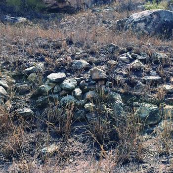
One more point deserves clarification as far as stone walling is concerned. This is the speculation that walling only represents ‘prestige’ when it is well coursed (see Huffman Reference Huffman2015). While Whitty (Reference Whitty, Summers, Robinson and Whitty1961) developed a very useful evolutionary framework to help archaeologists classifying dry-stone walls, there are massive differences in meaning and understanding between local African conceptions and archaeological constructs implied by labels such as P and Q walling. Amongst various sub-groups that make up the modern Shona speakers, dry-stone walls are referred to similarly as masvingo/maswingo/dzimbahwe, regardless of whether coursing is absent or present (see Chimhundu & Mangoya Reference Chimhundu and Mangoya2001; Hannan Reference Hannan1959). Thus, amongst groups such as Kalanga and Karanga, what archaeologists refer to as Leopard's Kopje (poorly coursed), Khami (mostly well coursed) and Great Zimbabwe (mixed coursing) walls are all known by these same names. What is interesting is that the walling of some major Zimbabwe culture settlements is a mix of roughly coursed, poorly coursed and, in some cases, well-coursed building styles. For example, while the stone-walled platform on the summit of Mapungubwe Hill appear to have some poor coursing, some of the terraces on Mapungubwe Southern Terrace can hardly be described as coursed (Fig 9); and yet some reconstructions associate this area with the elite. The key point is that such walling in construction technique resembles that on the summit at Mapungubwe and that known from other Leopard's Kopje and Khami sites that is locally described as maswingo/masvingo/dzimbahwe. This indicates that, to locals, both Leopard's Kopje and Khami walls are the same thing, but if we add chronology, we can conclude that the latter evolved out of the former.
A rough, if not uncoursed, terrace wall in an ‘elite area’ on the Mapungubwe Southern Terrace.

Admittedly, that Khami and Great Zimbabwe represented different political entities has never been an issue. What has been up for debate, however, is the hitherto ambiguous relationship between the two. Based on the chronological overlaps and significant differences in walling and local pottery, conceivably Khami would not have evolved out of Great Zimbabwe. This invites us to consider insights from Shona political processes for clues. As Chimhundu (Reference Chimhundu1992) has argued, the idea of expansive territorial states in southern Africa is not matched by the evidence. From the sixteenth century onwards, many polities co-existed on the landscape (e.g. Mutapa and Butua) and several other autonomous dynasties controlled territories in southern Zambezia (Beach Reference Beach1994). Great Zimbabwe and Khami co-existed on the landscape from the late fourteenth/early fifteenth century onwards. In fact, some Portuguese documents suggest that the Butua polity based at Khami was not only autonomous, but was uninterested in gold trade, because the lineages that controlled it were pre-occupied with cattle raising (Mudenge Reference Mudenge1974). Given that it is difficult to envisage how either Khami or Great Zimbabwe would have controlled the other in view of the 300 km that separate them, an inter-polity heterarchical relationship greased by self-governing lineages sounds the most probable. Furthermore, similar heterarchical relationships might have subsisted between Khami, Great Zimbabwe, Mutapa and many other chronologically overlapping polities in southern Zambezia.
This inter-polity heterarchy co-existed alongside malleable intra-polity hierarchies and intra-polity heterarchies. Within individual polities, power shifted between settlements associated with lineage heads in an ever-changing hierarchy of control from the local level to the centre. As illustrated by the Mutapa and Buhera dynasties (see Beach Reference Beach1994), succession rotated power between lineages, creating a series of capitals and a realignment of networks of power extending to the local level. According to Beach (Reference Beach1994), while the founder of the Buhera Dynasty was based at Gombe, power shifted to five other places before coming back to the Gombe area (not at Gombe itself). What is also interesting is that spirit mediums played an important counterpoising role within these polities. Lan's study of the spirit mediums in the Mutapa state demonstrated that they resided in their own homes and not at the centres of power. Furthermore, they played an intercessory role between the living and God via royal ancestors. Mediums led prayers for rain, they installed chiefs and were instrumental in dethroning incompetent chiefs. This separation of powers between religious leaders and chiefs was an important balancing act. However, just as chiefs had a hierarchy of control, so too did spirit mediums. The mediums of the founder of the states were more senior than those of later chiefs. This indicates that strategies involving both hierarchy and heterarchy were adopted at the intra-polity level, suggesting that they are often complementary and by no means mutually exclusive.
This mixed power strategy has resonance with examples elsewhere on the African continent, such as the inland Niger Delta in Mali (R. McIntosh Reference McIntosh2005; S. McIntosh Reference McIntosh1999a), Buganda in the Great Lakes (Davies Reference Davies2009; Reference Davies, Mitchell and Lane2013; Hanson Reference Hanson2009) and many others (see Howard Reference Howard, Howard and Shain2005). Archaeological excavations at multiple clustered urban sites in the middle Niger Delta in Mali exposed archaeological sites that were or less of the same size, hinting at heterarchical social complexification. S. McIntosh (Reference McIntosh and McIntosh1999b) suggested that Jenne Jeno was characterized not by coercion as a form of control, but by layered, counterpoised and competing forms of authority. Thus, authority was shared amongst different spheres, with no great man or woman monopolizing power (R. McIntosh Reference McIntosh2005). Indeed, Hanson's (2009) study of politics and conflict in Buganda unravelled that religious and political forms of authority were balanced to reduce the power of the kings of the polity. This constrained the dominance of kings over chiefs who ruled some of the provinces. Thus, in view of the situational adoption of hierarchy and heterarchy in Buganda, Hanson (Reference Hanson2009) argued that, in cases where hierarchies were created, communities marshalled aspects of heterarchy as a strategy to ensure accountable government even as the kingdom centralized. Therefore, within individual polities and between them, there was continual tension among multiple and competing centres of power and authority, resulting in negotiated strategies (Howard Reference Howard, Howard and Shain2005).
A consideration of scholarship on social formation of these examples in southern Zambezia shows that, in our region, not only have vertical hierarchical models of control been dominant, but alternative power strategies that may fall under the rubric of heterarchy (Crumley Reference Crumley, Ehrenreich, Crumley and Levy1995), while appropriate, have never been fully considered. This hindered the development of a more dynamic understanding of relations between and within political formations. However, the concepts of heterarchy and hierarchy must be applied not just contextually, but also recursively and flexibly. Such a framework of analysis requires a consideration of the context and an understanding of the temporal duration of the relationships under discussion. Doing so may accommodate the complex and often contradictory interplay of cultural processes giving form to political relations, be they ranked, unranked or otherwise.
However, regardless of where one is on the African continent, there are some challenges that must constantly be theoretically and practically negotiated. For example, that centres of power shifted across the landscape is not unique to the Zimbabwe culture: Shaka Zulu changed his capitals three times in just over 12 years; his successors had their own capitals, of different sizes. Cetshwayo's Ondini homestead was a provincial centre before he became king. Also, Tswana capitals changed, perhaps for environmental and political reasons. And of course, capitals also shifted in the Great Lakes area. While the causality of shifting capitals might be contextually different, archaeologically it presents the same challenge. How do we date the shifts in centres of power and identify the ever-changing hierarchies that resulted (see Chirikure et al. Reference Chirikure, Manyanga and Pollard2012 for discussion)? Rather than being a limitation, this challenge must force archaeologists to reflect dynamically on the tangible and intangible correlates of African political formations, instead of making stories out of the ‘easy options’.
In summary, a consideration of the relationship between Khami and Great Zimbabwe in light of the archaeological evidence from the two sites and comparative insights from Shona political processes endorse the view that these polities were heterarchical. Not only were relations between these sites clearly non-linear, but within them, impermanent hierarchies of control, counterpoised by heterarchical structures, appear to be the prevailing power strategy. Just as the relationship between Khami and Great Zimbabwe was not linear, so too was the relationship between polities that may have preceded them.
Conclusion
The traditional view that Khami was founded by the Torwa people more than 50 years after the demise of Great Zimbabwe sustained a parent–offspring relationship between the two. An analysis of archaeological evidence from the two sites highlighted material culture differences and significant chronological overlaps, suggesting that the relationship between these discrete polities was probably heterarchical. Recourse to Shona political processes indicates that, within the individual polities, malleable hierarchies and contextual heterarchies may have been used as a power strategy. This, however, requires further elaboration, and is the focus of our ongoing research at sites situated between Khami and Great Zimbabwe. What is now clear is that, as far as Great Zimbabwe and Khami were concerned, there was no big brother or big sister, and neither did the parent die after producing offspring—all attesting to the dynamism and richness of southern Zambezian socio-cultural and political processes.