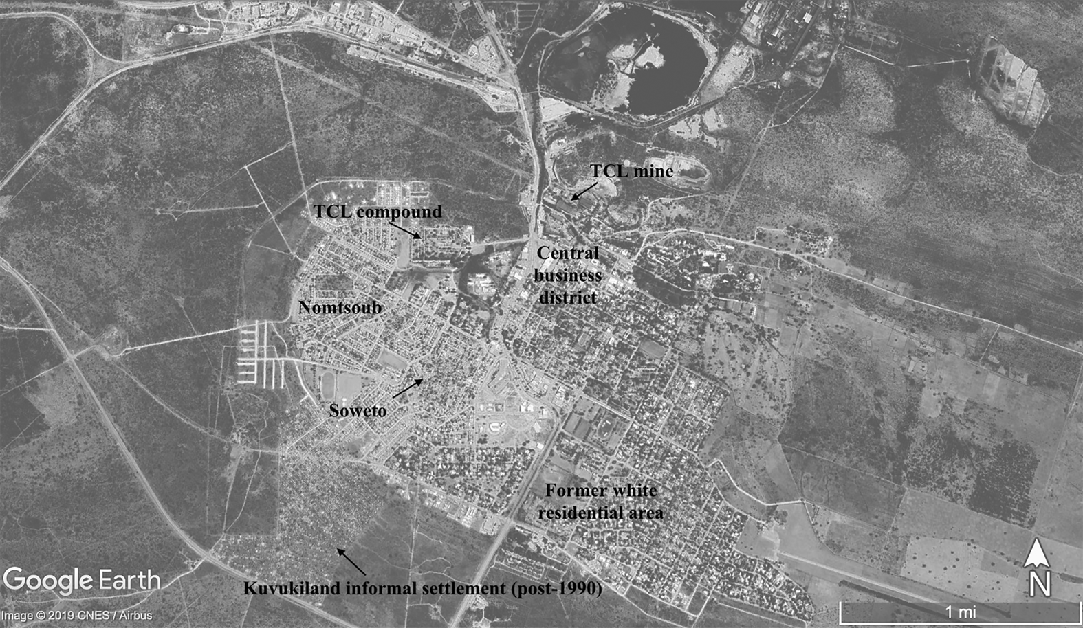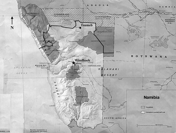


In July 1987, between four and five thousand employees of the multinational Tsumeb Corporation Limited (TCL) went on strike with the support of the Mineworkers Union of Namibia (MUN) at TCL's three mines in Namibia, including the company's copper mine and smelter in Tsumeb.Footnote 1 MUN was one of a series of unions founded in the mid-1980s in Namibia by workers’ committees and members of the nationalist South West Africa People's Organization (SWAPO). The majority of strike participants were Ovambo migrant laborers on short-term contracts brokered with TCL by the Owambo bantustan government in northern Namibia.Footnote 2 These workers, originating from northern Namibia and southern Angola, lived in TCL's barracks-like closed compound and were subject to repatriation to the north at the expiration of their contracts. One-third of the strikers lived long-term on a state-recognized basis in family housing in Tsumeb's African township, Nomtsoub (Fig. 1).Footnote 3 These workers lived south of a colonial veterinary and labor boundary called the Red Line, in the zone of colonial investment and settlement, the Police Zone (Fig. 2).Footnote 4 Township residents’ significant participation in the 1987 TCL strike contrasted with previous strikes in Tsumeb and Namibia more broadly, including the famed 1971–2 territory-wide general strike, which overwhelmingly involved contract laborers.Footnote 5 TCL fired the strikers and stalled on the workers’ demands. In March 1990, SWAPO took power in the first independent Namibian government, having won 57 per cent of the countrywide vote in United Nations-supervised elections.Footnote 6
Map of Tsumeb, Namibia. Source: Google Earth.*
*Adapted by author from Google Earth 7.3.2.5776, ‘Tsumeb, Namibia’, 9°14’40.30” S and 17°42’40.89” E, elevation 16937 ft. (29 Oct. 2018), viewed 14 Sept. 2019.

Map of South West Africa/Namibia showing the Red Line. Source: CIA.*
*Adapted from a 1978 map of Namibia's bantustans produced by the Central Intelligence Agency available online at the Perry Castañeda Map Collection at the University of Texas at Austin Libraries, https://legacy.lib.utexas.edu/maps/africa/namibia_homelands_78.jpg, accessed 11 Dec. 2019. The author modified the original map by adding border information obtained under a Creative Commons licence, see https://commons.wikimedia.org/wiki/File:Red_Line_SWA_1966.svg, accessed 11 Dec. 2019.

This article examines tensions between, on the one hand, African communities of survival and political action and, on the other, rigid colonial and company structures intended to maintain economically and politically expedient divisions between Africans in urban areas.Footnote 7 Colonial South West Africa (SWA)'s territorial infrastructure of African labor recruitment and distribution, as well as the urban spatial organization and infrastructure that reproduced colonial labor categories on a local scale, were key to South Africa's translation of apartheid to SWA in the 1950s.Footnote 8 Living amid configurations of housing, water pipes, and electricity lines meant to divide northern contract laborers from more permanent urban residents, township residents moved and transferred scarce resources between the compound and township in ways that supported their livelihoods and undermined colonial and company structures. Although African communities of political action tended to form around colonial labor categories, with northern contract laborers organizing to oppose the contract labor system from the early apartheid period, the colonial state was unable to enact sharp social distinctions between northern contract laborers and long-term Police Zone residents in the realm of everyday life. Housing and infrastructure embodied the welfare-providing and coercive aspects of TCL and the colonial state toward Africans living in Tsumeb. Residents’ survival strategies wore away colonial infrastructure, strengthening alternate urban social geographies, and by the 1980s the withdrawal of TCL and state subsidies caused Tsumeb's apartheid infrastructures to collapse. In this context, northern contract laborers and long-term Nomtsoub residents confronted TCL and the colonial state in the 1987 TCL strike.
This article contributes to the historiography of Namibia during apartheid by disaggregating the Namibian working class and analyzing the legacies of colonial labor policies. Delineating the particular social and political effects of apartheid in Namibia broadens scholarly knowledge of South African empire-building in Southern Africa.Footnote 9 Historians of Namibia have taken for granted the Red Line's significance as a socioeconomic dividing line and instrument of colonial rule, but, with the exception of Giorgio Miescher, they have not examined its origins and functions. In Miescher's analysis, officials used the Red Line ‘to physically mark the transition between “white” European Southern Africa and the “black” interior, between that which was “healthy” and that deemed “diseased”’.Footnote 10 The Red Line also served as the linchpin of colonial SWA's bifurcated labor system. Officials repurposed police checkpoints and fencing along a boundary already being used for purposes of racial segregation and livestock disease control to prevent Africans from Namibia's densely populated northern third from entering the Police Zone outside of state-mandated migrant labor recruitment.Footnote 11 Recruiting organizations — from 1943, the South West Africa Native Labor Association (SWANLA) — distributed male contract laborers to white employers, to whom they were bound for the duration of their contracts. While residents of the Police Zone had the chance of attaining permanent urban residence via the 1952 Natives (Urban Areas) Proclamation, northern contract laborers were transported back to the reserves north of the Red Line at their contracts’ expiration.Footnote 12 During apartheid, the former could rent, but not own, municipal family houses, while the latter were isolated, absent their families, in compounds.
In addition to serving as a veterinary and racial settlement boundary, the Red Line divided black Africans according to the type of wage labor on which they depended. Two literatures provide an analytical framework. First, a recent historical and anthropological literature examines how infrastructure acts as a carrier of politics, and how the properties and operations of materials and technologies affect political processes.Footnote 13 Antina von Schnitzler argues for the importance of technical devices, such as prepaid meters in apartheid and post-apartheid Soweto, as conduits of state ethical and political visions as well as grassroots politics.Footnote 14 She suggests, ‘it could be argued that apartheid was precisely about infrastructures’ to limit African mobilities.Footnote 15 Infrastructures, furthermore, are ‘“unstable” objects … [that] once they leave their makers … can be retooled for other ethical and political projects’. In Namibia, town-level layouts and infrastructures underpinned the contract labor system, which was crucial to the profitability of Police Zone industries. But the colonial state's bifurcated system of labor control in Namibia, and the corresponding segregation of northern contract laborers and long-term urban residents in towns, mismatched shifting, contingent African solidarities and identities on the ground. This mismatch allowed Africans to pursue survival strategies that defied colonial structures and, eventually, to transform state infrastructure and welfare provision into a national and nationalist issue.
Second, a key set of debates in African history centers on the relationship between ethnicity, African and colonial agency, and modalities of colonial rule. Historians have grappled with the multiple and contradictory nature of ethnic thinking, since it both lies at the heart of people's collective historical and moral understanding of who they are and where they came from and, on the other hand, provides discursive fuel in struggles for power and resources.Footnote 16 Scholars have examined the changing relationship between African and European institutions in Namibia — including the South African military, the colonial and postcolonial state, and ‘traditional’ African leadership structures — in shaping African ethnicities and solidarities.Footnote 17 In the urban Police Zone during apartheid, Africans struggled over the limits of urban and national belonging and exclusion using the idioms of ethnicity. In the heat of the late liberation struggle, however, it became politically expedient for SWAPO, and seemed a matter of survival to many Namibians, to shift attention to ‘bread and butter’ issues that cut across colonial labor categories as well as African ethnic communities.
The first section of this article argues that the translation of apartheid to Namibia involved remaking Police Zone urban geographies to bolster the separation of northern contract laborers from long-term urban residents. In Tsumeb, the implementation of apartheid in the 1950s gave greater infrastructural expression to an existing occupational division between northern contract laborers, who were primarily underground mineworkers, and Africans from the Police Zone, who worked on TCL's ranches and produce farms or elsewhere in town. Northern contract laborers and long-term location residents responded to this infrastructural implementation of apartheid distinctly and on different timelines. The second section illustrates the situational and contingent nature of ethnicity after the 1971–2 general strike, when South African bantustanization tactics forced ethnicity more prominently into the realm of high politics. Africans in Tsumeb used the language of ethnicity to debate what might be lost and gained in a future without the Red Line. The third section argues that the final crumbling of company and state subsidies of urban housing and services in the 1980s delinked resource access from old colonial labor categories, segregating Nomtsoub's poorest residents from its aspirant middle class. These local factors prompted the joint participation of compound and Nomtsoub residents in countrywide anticolonial, pro-SWAPO politics. In Tsumeb, the 1987 TCL strike exemplified this activism.
CORPORATE PATERNALISM, UNSTABLE INFRASTRUCTURES, AND AFRICAN SURVIVAL STRATEGIES IN EARLY APARTHEID TSUMEB, 1946–71
The German and British Otavi Minen und Eisenbahn Gesellschaft (OMEG) established Tsumeb mine in 1906 and built Tsumeb as a company town to sustain a labor force in an unfavorable spot in southern African labor markets.Footnote 18 OMEG provided houses and rations for African workers, largely to siphon off migrant laborers from tentacles of the Rand mines’ recruiting apparatus. The South African Custodian of Enemy Property confiscated the mine in 1940. In 1946, when representatives of the North American company Newmont Mining visited to consider buying the abandoned mine, they found 200 small houses that OMEG had built for African mineworkers, as well as 59,817 hectares of timberland and farms that employed Africans.Footnote 19 One visitor, the mining engineer and manager Henry DeWitt Smith, who later became Newmont's director in New York, noted that OMEG had gone into cattle raising to undersell local producers — likely including Africans — by selling subsidized beef and milk to white employees. OMEG provided rations to African workers and their households as part of their compensation. TCL was incorporated in 1947 to purchase and repair the disused OMEG mine.Footnote 20
TCL invested money into reviving the mine and initially continued OMEG's strategy of providing housing to foster African residents’ consent. Yet TCL paternalism in the late 1940s and early 1950s had different impacts on Africans from the Police Zone and northern contract laborers, because these two classes of African workers had responded differently to contrasting experiences of German and South African colonial rule. While the German period saw the dispossession, extermination, and exile of Africans in the Police Zone, including Hereros in the northern Police Zone, SWA north of the Red Line did not come under colonial control until after South African conquest in 1915.Footnote 21 In the decades following the 1904–7 war with Germany, Hereros intent upon rebuilding a pastoral economy refused to accept any work from TCL except on company farms or in the smelter, because both forms of labor allowed them to spend periods of time in the surrounding countryside, where they could keep livestock.Footnote 22 Barred from entering the Police Zone except as contract laborers after 1935, Africans from north of the Red Line who lived in Tsumeb were typically male mineworkers who lived in OMEG company houses for African workers.
TCL bought Tsumeb mine during a period of accelerated white settlement and expulsion of African livestock from white-owned farms, so that TCL patronage of the town's African residents formed a wedge against proletarianization for Police Zone Africans in particular, even as it signified a rapid narrowing of opportunities for them to act as agricultural producers in their own right.Footnote 23 Residents’ water was pumped from the soluble rock containing Tsumeb's copper, using machinery that had ground to a halt when the mine was shuttered.Footnote 24 By late 1957, TCL had added 395 houses to OMEG's existing stock, as well as a primary school.Footnote 25 TCL built the ‘domestic water lines, sewerage, and power lines’ that served Nomtsoub.Footnote 26 Christina Somses remembered Tsumeb and TCL as a safe landing place when her father, who had previously kept some cattle on a settler farm about thirty kilometers north of Tsumeb, fought with his white employer and was evicted.Footnote 27 Because Christina's mother had ten sisters with relations spread throughout the area, including Tsumeb itself, Christina and her parents were able to settle easily in Tsumeb in the 1950s. Translating for her mother, Christina's daughter, Julianne Somses, said:
The houses were free at that time, and we were also getting food from the mine. Every week, we were getting meat and porridge and tomatoes and something like that. It was a town like you have been having — how do you call it, in a word? Manna? Milk and honey!
Christina Hanis, who moved to Tsumeb in the 1950s, recalled the perks that came with her father's work on TCL's cattle farms.Footnote 28 She said, ‘Every Friday and Saturday we got meat and vegetables. We didn't buy. It was very free. Getting food was free. Everything was free’. Africans living long-term in Tsumeb saw themselves as engaged in a compact with TCL, in which they or family members worked for TCL and TCL provided basic necessities to Nomtsoub residents.
On the other hand, from TCL's arrival in Tsumeb, northern contract laborers’ common experience of surveillance and control in the mine and company compound prompted their participation in territory-wide patterns of northern contract laborers’ activism that drew the attention of officials in Windhoek. While OMEG had housed African mineworkers in detached houses, from at least 1950 TCL isolated its SWANLA contract laborers in a closed compound, which was separated by a buffer zone from the location proper.Footnote 29 In this context, northern contract laborers in Tsumeb and other industrial centers challenged authorities’ use of infrastructure to monopolize water resources, which they wanted to use to make beer.Footnote 30 In 1953 and early 1954, northern contract laborers in Luderitz and Walvis Bay had clashed with police over beer brewing.Footnote 31 In June 1954, some 500 TCL northern contract laborers closed in on police searching for illegally brewed beer hidden in the mealie field behind the compound, armed with ‘walking sticks, axes, and assegais’ and throwing rocks.Footnote 32 The workers kidnapped a white constable, but released him later that evening. The following morning, the district commander of the South African Police, along with 25 policemen, raided the compound and adjoining fields, destroying 250 gallons of ‘kaffir beer’ and confiscating two three-ton truckloads of axes, assegais, walking sticks, and other ‘dangerous weapons’.Footnote 33 No one could be prosecuted due to the communal nature of the compound and residents’ reticence.
In the late 1950s, South African Native Affairs officials mandated administrators throughout the Police Zone to re-plan towns not only to ensure racial segregation and influx control, but also to segregate northern contract laborers and long-term urban residents to protect the SWANLA contract labor system. There was a convergence of TCL cost-saving interests and the colonial state's will to consolidate urban areas under government control, so that TCL sold its houses in Nomtsoub, including the old OMEG houses, to Tsumeb's Village Management Board (VMB) for £12,000 in 1958.Footnote 34 TCL negotiated that the houses would remain open to TCL workers first, should TCL need the worker housing in the future, though this seems not to have happened. The effect was to absolve TCL of responsibility for housing maintenance and infrastructure in Nomtsoub, shifting the burden to the VMB.
Notwithstanding TCL's introduction of the closed northern contract laborers’ compound and the consolidation of family housing stock under government control, urban infrastructure failed to bend ground level realities in Tsumeb to match official categories. SWA's post-Second World War economic recovery and South African officials’ new urban planning requirements sparked a building boom in Tsumeb in the 1960s. However, SWANLA was ill-equipped to furnish construction contractors with African workers experienced in construction trades. During Tsumeb's building boom, contractors cobbled together workforces of northern contract laborers, migrant workers from elsewhere in the Police Zone, long-term Nomtsoub residents, and black and coloured South African workers.Footnote 35 Due to the itinerancy of construction work and the lack of public accommodation in Nomtsoub for African migrant workers, contractors housed their diverse workforces in temporary quarters.Footnote 36 In 1961, construction of a compound for TCL's new lead and copper smelters got underway.Footnote 37 In April 1961, location authorities reported 400 coloured and black, South African and South West African, and Police Zone and SWANLA contract workers for Lewis Construction living in and around the smelter compound they were in the process of building. The Bantu Affairs Commissioner in Grootfontein suspected that ‘the presence of beer in the neighborhood of the compound attracts laborers from the Main Compound of Tsumeb Corporation’.Footnote 38
During the 1960s, as the VMB cracked down on African migration into town and TCL stepped back from previous practices of housing provision, Africans who failed to secure official Nomtsoub housing established themselves in self-constructed, transitory worker camps in and around the location. Some opted to live in self-constructed housing to avoid paying rent for accommodations that apartheid regulations barred them from owning, or because their income sources, such as beer brewing and sales, depended on their being off of official rolls of urban residents.Footnote 39 These dwellings and livelihoods were aloof from colonial labor categories. In 1965, the town clerk told the Secretary of SWA of ‘200 people who are housed outside the location in temporary self-constructed dwellings’.Footnote 40 Some were employees of the Roads and Public Works Departments, but others had been ‘resident on the Tsumeb Corporation farm and were forbidden to stay there any longer’.
The story of Pieter Hermanus Swartz illustrates how influx control and a housing shortage chipped away at Police Zone Africans’ understanding of Tsumeb as a place of refuge. Swartz was born and raised in Tsumeb but had spent most of his life moving between Tsumeb and various farming towns. In 1962, when he returned to Tsumeb after a five-year stint in Outjo, 200 kilometers southwest, and asked the location superintendent for help getting a house, the superintendent replied that he ‘would wait two years’ and ‘shed tears’. In a letter to the Chief Bantu Affairs Commissioner, Swartz explained:
I was born at Tsumeb. Grew up here, and started school here. My mother died in Tsumeb. Before the great rain in 1934 I trekked with my Pa to Grootfontein and stayed there until 1947. In 1947 … I returned to Tsumeb and joined [TCL]. And worked nine years. On [experiencing] certain difficulties I resigned, and went to Outjo. … Because it has not rained for the past few years, I returned again to Tsumeb. And I got work at Tsumeb, and am working [for TCL].Footnote 41
Swartz ended up sleeping ‘in a little anteroom of [his] sister's house (a hut)’ near a TCL cattle post.Footnote 42 A month later, in late October, the time of year when Namibians begin to expect rain, Swartz wrote again to the Chief Bantu Affairs Commissioner:
At Tsumeb it has started raining, and there where I sleep in a hut, the water runs through like a river. Now you my Great Boss, where must I go. Where will I sleep. I came to look for a living [lewesoek] and work at the Corporation. I beg for help.Footnote 43
Having stopped building and maintaining Nomtsoub's housing stock, in the late 1960s TCL responded to Tsumeb's African population growth by transferring responsibility for location infrastructure to the local state as well. Between 1958 and 1968, Nomtsoub's population increased by 87 per cent, from 2,110 to 3,956, while the number of houses in Nomtsoub increased by only 45 per cent, from 561 to 814.Footnote 44 In June 1968, when Tsumeb became a municipality, TCL transferred the town's electrical, water, and sewerage reticulation systems, as well as the newly tarred roads, to the municipality for one rand.Footnote 45 The municipality would now have to pay TCL artisans for installation and maintenance tasks that they had previously been doing free of charge. TCL took this opportunity to make profit, announcing in June 1971 that it would raise the cost of these services retroactively from 1 January 1971.Footnote 46 TCL claimed to have been undercharging the municipality since its founding. The municipality closed all its TCL accounts at the end of 1971, taking out a government loan to hire its own artisans.Footnote 47
While the official purpose of Tsumeb's administrative and infrastructural organization was to create two worlds — the TCL compound and Nomtsoub — the porousness of influx control in Namibia and the unintended consequences of infrastructure's construction fostered ambiguity. Removals to bantustans occurred, but many Africans on the fringes of the location remained in self-constructed dwellings or crammed into existing housing as lodgers or ‘visitors’.Footnote 48 In August 1970, the location superintendent wrote that the workers’ camp of the construction company Nienhaus and Sons was ‘degenerating into a private location’.Footnote 49 In September 1970 he stated that the ‘zinc buildings … [were] developing into a squatter village [plakkersdorp]’.Footnote 50
In dwellings and business spaces that Africans carved out without reference to official labor categories, infrastructure emerged as a point of contention. Officials sought to use infrastructure to enforce sociopolitical distinctions that protected SWA's vital labor resources in the north. Africans needed infrastructure to access resources, especially water, that were crucial to their livelihoods. For Africans who could not, or chose not to, live in municipal houses and engage in officially sanctioned wage labor, beer brewing was an important income source. There was a spate of conflicts between African residents and officials over beer brewing during the 1960s, but especially after the 1968 founding of the municipality. While in 1958 the location superintendent reported destroying 587 gallons and, in 1962, 65 gallons, in 1968 he reported destroying ‘4000 gallons of beer … at a time’.Footnote 51 In May 1969 alone, the location superintendent reported destroying 2,000 gallons of beer hidden in the buffer area outside of the location.Footnote 52 In June and August 1969, local authorities reported destroying hundreds of gallons each month.Footnote 53
While officials assumed that northern contract laborers appropriated resources allotted to long-term Nomtsoub residents, Africans mobilized shifting and situationally contingent identities to facilitate the access of a wide array of Nomtsoub and compound residents to water and water infrastructure. In September 1969, the location superintendent reported that ‘three water meters were damaged and 6 water pumps [waterkrane] were removed from the pipes in the Ovambo-section’, causing water to gush from the pipes.Footnote 54 The location superintendent ethnicized supposed illicit African appropriation of water resources and infrastructure, hypothesizing that the pumps were removed by ‘[O]vambos who come fetch water in the location to brew beer’. Furthermore, he implied that Nomtsoub residents objected to northern contract laborers’ use of resources allotted to them, noting that ‘[t]he taps are all closed by the house residents after warnings about water wastage’. In September 1970, the location superintendent indicated: ‘[I]t happens every day that kontrak-ovambos go fetch water at the new family houses for brewing beer’. That month, the superintendent described Nomtsoub residents ‘tinker[ing] with the lights’ in the location, perhaps in attempt to extend electrical connections to others, sometimes damaging the electricity grid.Footnote 55 It seems probable that at this stage Africans in the compound and location saw these unauthorized uses of Nomtsoub infrastructure as a means to circumvent inconvenient obstacles to their livelihood strategies, not as transgressions of official sociopolitical categories that they did not recognize.
Africans’ unsanctioned use of infrastructure increased amid an ethnicization of the Namibian liberation struggle and a narrowing of the field of anticolonial movements in the territory. Up through the early 1960s, the liberation movement in SWA was characterized by a loose coalition of anticolonial organizations petitioning the UN to intervene against South Africa. The International Court of Justice's 1966 ruling of no jurisdiction in Ethiopia and Liberia's case against South Africa damaged grassroots trust in the international community's ability to lead Namibian decolonization. In 1965, SWAPO had secured the Organization of African Unity's exclusive recognition and promise of financial aid, because SWAPO was the only nationalist organization willing to pursue independence through armed struggle. After SWAPO's armed wing, the People's Liberation Army of Namibia, engaged South African security forces for the first time on 26 August 1966, in the battle of Omgulugwombashe in Ovamboland, South Africa targeted SWAPO as the primary anticolonial agent in Namibia. In the 1970s, the South African government would double down on its implementation of bantustan policy in SWA — and use the new bantustan structures in an attempt to fracture anticolonial organization along ethnic lines.Footnote 56 As South Africa might have hoped, these actions upped the ethnic valence of Africans’ acts of urban incursion and infrastructural resistance. However, Africans did not necessarily take up these ethnic discourses in the fragmenting ways that South Africa intended.
THE 1971–2 GENERAL STRIKE, ETHNICITY, AND AFRICAN POLITICS
The territory-wide general strike of December 1971 and January 1972 marked the zenith of northern contract laborers’ agitation against the specific injustices of the contract labor system. It also touched off a scramble between SWAPO and South African authorities to write northern contract laborers’ actions into opposing narratives of the Namibian liberation struggle. On 13 December 1971, some 6,000 workers living in the northern contract laborers’ compound in Windhoek's African location, Katutura, refused to go to work, demanding to be repatriated to the north until employers struck a deal with workers’ representatives.Footnote 57 Five days into the strike, on 18 December, white foremen who showed up for work at TCL saw almost no Africans on the job.Footnote 58 Some 3,700 TCL African workers had elected to remain at home until they were permitted to ‘return to Ovamboland and join their fellow strikers’.Footnote 59 Eventually, 13,500 workers were on strike, shutting down 11 mines and affecting 23 work centers throughout Namibia.Footnote 60
While SWAPO quickly claimed from exile in Lusaka that the strike was a nationalist act orchestrated by party operatives inside Namibia, South Africa used the strike to propagate stereotypes of SWAPO as an ‘Ovambo’ party. On 4 February 1972, SWAPO issued a press statement that, contrary to South African depictions of an ‘Ovambo strike’ that had been resolved with the dissolution of SWANLA, the strike was ‘directed against the South African Government … for the independence of Namibia’ and ‘in response to SWAPO's call … to “redouble the national efferd [sic] to free Namibia within the shortest possible time”’.Footnote 61 Neither contemporary press coverage nor academic analyses link the strike directly to SWAPO, however. Press coverage attributed the strike to Ovambo workers, not to SWAPO.Footnote 62 Richard Moorsom argued in 1977 that SWAPO and its predecessor, the Ovamboland People's Organization (OPO), played a vital role in equipping northern contract laborers to organize the general strike — not that SWAPO leaders orchestrated the strike from above.Footnote 63 Gretchen Bauer later demonstrated that the strike organizers operated independently of SWAPO and surprised SWAPO's leadership, contrary to claims in SWAPO publications that party activists spent months organizing the strike.Footnote 64
After the strike and subsequent attacks against chiefs and the colonial state in Ovamboland, South Africa pushed forward with its plans of bantustan ethnic polarization, singling out Ovamboland, while SWAPO's claim of organizing the strike raised its international profile as the vanguard of Namibian nationalism. The January 1972 strike settlement emerged from talks between colonial officials, employers’ representatives, and, to an extent, African ministers from the Owambo and Kavango bantustans.Footnote 65 When unrest continued in Ovamboland into February, the colonial state declared what amounted to martial law there, banning public meetings, allowing for indefinite detention without trial on suspicion of wrongdoing, and restricting ‘unauthorized’ persons from visiting the area.Footnote 66 In 1973, the UN recognized SWAPO as the ‘authentic representative of the Namibian people’. In 1974, SWAPO left the National Conference (NC), a coalition of major anticolonial political parties.Footnote 67
The split in anticolonial politics after 1971–2 had an ethnic component. In late 1971, NC chairman and Herero paramount chief Clemens Kapuuo explained that ‘Hereros generally supported the strike’ and endured ‘a somewhat milder form of the contract system’, though ‘they did not join [the strike] because it was arranged by the compound residents, who had not consulted the residents in the rest of Katutura’.Footnote 68 In January 1975, soon after SWAPO left the NC, Kapuuo condemned SWAPO as an Ovambo party and called for the division of Namibia along the Red Line. Saying that ‘the tribes of central and southern parts of South West Africa’ would ‘never allow their lands and their future to be decided by a political organization of just one tribe which was not elected by them’, Kapuuo participated in the 1975–7 Turnhalle Constitutional Conference.Footnote 69 Through Turnhalle, South Africa sought to involve representatives of government-acknowledged Namibian ethnicities in drafting a transitional constitution independent of the UN or SWAPO. The NC then split, with member organizations either aligning with SWAPO or participating in Turnhalle.
Meanwhile, SWAPO's emergence as Namibia's primary liberation movement and South Africa's campaign of ethnicization meant that SWAPO's Ovambo-ness became a topic of debate in Namibia. But because the boundaries of Ovambo and Police Zone identities and solidarities were less clearly defined on the ground than officials surmised, ethnic discourses could build up political communities as well as break them down. Though ascribed ethnic identities — and the colonial state's ethno-labor categories, associated with region of origin and mode of colonial labor recruitment — were important in the way that Africans identified themselves and others, Africans in Tsumeb delinked location belonging from these categories and linked it to acts of self-fashioning involving language, urban style, and social embeddedness. Africans with ascribed Ovambo identities who became part of the fabric of SWA locations, including Nomtsoub and Kuisebmond in Walvis Bay, could ‘become’ Damara or Herero. Albertina Shikonda and Lucia Amadhila, Ovambos who have lived in Walvis Bay since childhood, described how their families’ long-term settlement in town, far from Ovamboland, meant a recalibration of where they belonged and were known. ‘We became Hereros’, they said.Footnote 70
As much as these existential shifts entailed gaining a new community, they involved a loss of old identities that sparked anxious discourses about Namibia's political future. In particular, they addressed the stakes of a future when northerners’ movements were unencumbered by the Red Line. The story of twenty-four-year-old Elias Theofilus and Thomas Martin, which comes from the police investigation into Theofilus's fatal stabbing on Christmas Eve 1973, demonstrates how it was possible to become Damara, as well as the stakes of becoming a long-term urban resident, in post-general strike Tsumeb.Footnote 71 The way Martin and other witnesses made sense of Theofilus's murder — and conjectured who did it — suggests that while Martin and Theofilus's ascribed ethnicity was probably Ovambo, they considered themselves to be Damaras, where being ‘Ovambo’ or ‘Damara’ had less to do with bloodlines than patterns of residence, type of employment, and material culture.
According to the testimonies of friends and onlookers, Theofilus was stabbed by a group of Oshiwambo-speaking strangers coming from the direction of the TCL compound. That evening, two of Theofilus's childhood friends, both identified in court documents as Damaras, and his school-age brother, identified as ‘Ukuanyama’ (Ovambo), pulled up to Theofilus's house in a van.Footnote 72 Theofilus and his housemate, Thomas Martin, identified as ‘Ondonga’ (Ovambo), were outside chatting when their friends arrived and a group of strangers approached.Footnote 73 Language and competing understandings of masculinity and adulthood featured in the clash between Theofilus and one of the strangers that followed. After a brief scuffle when ‘an Ovambo man’ asked Theofilus to stand aside so that he could pass between the van and a fence, the Ovambo stranger said something ‘in [U]kuanyama language’, to which Theofilus responded in Afrikaans, ‘I am just as much of a man as you are’. The stranger turned and insulted Theofilus ‘in Ondonga language’, sparking exchanges that escalated into threats. After stabbing Theofilus in the neck, the stranger ‘escaped between the bushes in the direction of the TCL compound’.
Witnesses characterized Theofilus's attacker in ethnic terms, linking ethnicity strongly to material objects. Police arrived on the scene to find Theofilus lying dead in the entryway of a neighbor's house, with what one onlooker, identified as ‘Ukuanyama’, described as a ‘bloody Owambo knife’ on the floor next to him.Footnote 74 With the case still open in September 1974, Martin made a second statement to the police, distinguishing Theofilus and himself from Theofilus's attacker in terms of ethnicity. He argued that the knife found beside Theofilus ‘[was] not the knife of the deceased, but an Owambo knife. We Damaras do not use knives like that. The deceased was also a Damara’,Footnote 75 Yet Theofilus understood when his attacker spoke to him in Oshikwanyama, even though he responded in Afrikaans.
In addition to breaking down social boundaries between northern contract laborers and long-term urban residents, Africans’ transgression of the spatial configuration of northern contract laborers and long-term urban residents’ housing in Tsumeb destabilized a kind of male Ovambo contract laborer identity associated with the SWANLA contract system. As SWAPO gained international recognition, Africans with ascribed Ovambo ethnicity in SWA towns used an ethnically specific discourse to discuss what might be lost and gained in a political future when Africans from north of the Red Line could choose where they lived and worked. For some northern contract laborers and their communities, Africans who acclimated too thoroughly to the ways of Police Zone towns were ombwiti or mbwiti.Footnote 76 According to Christian Williams, ombwiti means ‘weeds’ in Oshiwambo and resonated strongly during SWAPO's spy crisis in exile during the 1980s.Footnote 77 Becoming ombwiti could enable one to evade the contract labor system. Mike Heita said, ‘As much as [northerners] are here, they start to stay in Tsumeb or Walvis and start to speak Afrikaans. Then it is easy to be accommodated. So you don't go the route of [contract labor] recruitment now. If you go and ask for employment, then you are given a contract [directly from an employer] and now you are employed’.Footnote 78
From the perspective of some northerners, ombwiti were soft, unable to cultivate pearl millet or build a traditional house, afraid of hard work and sacrifice, and their vernacular tongue, if they spoke it at all, was tinged with Afrikaans or another Police Zone language. Eino Huauanga said that being called ombwiti was ‘not a nice thing’. He elaborated that he could tell someone his age who grew up ‘in the north’ rather than in ‘towns’: ‘I will exactly know that he is Oshiwambo-speaking. Because in Oshiwambo there is no letter “r”. … Mostly they confuse the “r” and the “l”. I know, “Oh, oh, this guy. He is from the north”’.Footnote 79
For several generations of Africans born north of the Red Line, the contract labor system sculpted gendered economic roles and measures of adulthood. Over the course of the 1970s, as the distinctions that the Red Line had drawn between northern contract workers and long-term urban residents wore away, this kind of Ovambo-ness matched realities on the ground less and less. In the late 1970s and 1980s, changes in TCL and state policy reconfigured the geography of Nomtsoub and the TCL compound so that residents were grouped less by colonial labor category or ethnicity than by ability to pay for housing and urban services. The apparent withdrawal of TCL and the state from provision of these resources contributed to African Tsumeb residents’ mass political mobilization across colonial labor categories under SWAPO auspices.
FISCAL APARTHEID, AFRICAN INFRASTRUCTURAL ACTIVISM, AND THE TCL STRIKE, 1976–87
After the end of Turnhalle in 1977, South Africa decentralized power and fiscal responsibility to a series of transitional administrations in Namibia, and over the course of the 1980s, amid sanctions and mounting diplomatic censure, foreign companies investing in South Africa-occupied Namibia faced pressure to move their assets and earning power elsewhere. The result was a drying up of available capital to build, maintain, and replace urban housing and infrastructure as poorly funded municipalities struggled to take up the former role of multinational companies. Events in Tsumeb and elsewhere in Namibia reflect a broader privatization of profit in Southern Africa in the 1980s and 1990s.Footnote 80 By the mid-1980s, the issue of public and private retraction of social commitments resonated with Africans across old colonial labor categories and thus became a national issue — and one that SWAPO could use to bring an enlarged grassroots politics in line with its nationalist cause. Due to the particular implications of ‘fiscal apartheid’ in Namibia, and in the context of the rise of joint union-community activism in South Africa, the 1980s saw an upwelling of class-based and anticolonial organization that brought northern contract laborers and African Police Zone residents together.Footnote 81
By the early 1970s, members of Nomtsoub's swollen population were living in dilapidated houses that were beginning to collapse. Tsumeb's Director of Non-White Affairs wrote that in January 1973 ‘house Nr. 795 [was] demolished because it partly collapsed and house Nr. 435 was evacuated because it presented a danger for inhabitants’.Footnote 82 In February 1975, he noted that ‘several houses had to be demolished because they became dilapidated and a few collapsed in on themselves’. In 1976, after years of entreating the government in Windhoek, the municipality obtained a loan of R1,000,000 to enable the construction of 117 houses.Footnote 83 The municipality quickly started demolishing and replacing old houses.Footnote 84 Municipal officials requested that the South African government write off outstanding loans on houses slated for demolition to minimize rent increases on the new houses, but with the decentralization of power to the Namibian transitional government came a tightening of state purse strings that forced municipalities to privatize urban services.Footnote 85 The municipality had held down rents for the houses slated for demolition for ‘reasons of humaneness’ and possibly fear of a potentially ‘explosive’ political situation.Footnote 86 In September 1977 some Nomtsoub residents were paying R9 per month.Footnote 87 Asking for loan forgiveness in March 1978, the town clerk noted that few occupants of the old houses would be able to pay rent for the new houses, which ‘as a result of increases in building costs’ ran ‘between R30 and R40’.Footnote 88 The government refused to write off the loans, and the municipality increased rents.
Rapid growth in Nomtsoub's population in the late 1970s and 1980s forced the municipality to stop demolishing crumbling houses. They were the only houses new arrivals to Nomtsoub could afford. At the end of the Turnhalle Constitutional Conference, in September 1977, the South African parliament created new administrative structures for a supposedly autonomous SWA multiracial government.Footnote 89 In October 1977, the new government repealed influx control, including checks on African entry to the Police Zone from north of the Red Line, causing additional migration to Tsumeb. Between 1977 and 1982, Nomtsoub's total population increased by 42.3 per cent, from 4,828 to 6,870.Footnote 90 The withdrawal of influx control, furthermore, increased the concentration of northerners living in Nomtsoub proper. Nomtsoub's total population of northerners, not including TCL compound residents, spiked by 52.1 per cent between 1977 and 1982, from 1,821 to 3,800.Footnote 91 According to a September 1977 report:
Although the average number of residents per house increased to 4.8, as appears from the census of December 1976, up to 15 people are found in a two-room house. The immediate consequence is that even with the construction of 117 houses, only 45 houses could be emptied from the dilapidated area.Footnote 92
Furthermore, the Town Clerk wrote in 1979, ‘[h]ousing had to be provided and against our wishes … we had to allow these dangerously dilapidated huts [sic] to be inhabited. 80 of the huts are occupied by Paupers and Pensioners, [but] the rest of this group … are [inhabited] by families’.Footnote 93
By the mid-1980s, the new Nomtsoub houses were home to a small, aspirant middle class, while Nomtsoub's newest, poorest residents crowded into the location's cheapest houses. The part of Nomtsoub where these houses are located came to be called Soweto, after Johannesburg's South West Townships. In 1985, the National Building and Investment Corporation of SWA estimated that 93 per cent of Soweto households could not afford to pay anything for house rent after attending to basic subsistence needs, while a mere three per cent could afford more than R130 per month.Footnote 94 On the other hand, only 70.9 per cent of households in the rest of Nomtsoub had no remaining resources after meeting basic subsistence needs, while fifteen per cent — a considerable 115 out of a total of 819 surveyed households — could afford more than R200 per month. As a result of mounting municipal debt and political pressure toward privatization from Pretoria, the municipality ended its subsidies of housing and services in the mid-1980s. Between 1984 and 1985, the municipality adjusted house rents to reflect the real costs of water, electricity, and housing maintenance, and began installing water and electricity meters to monitor and charge for individual households’ resource use.Footnote 95 House rents had last been adjusted in 1978.
From the early 1980s, furthermore, Newmont and other foreign investors in Namibia and South Africa struggled to retain control of their assets amid anti-apartheid disinvestment. In early 1981, falling copper prices led Newmont to move its resources more firmly into gold.Footnote 96 In the early 1980s, US city and state legislatures voted to withdraw millions of dollars of public pension funds invested in US companies doing business in South Africa and Namibia, including Newmont.Footnote 97 Over the course of the decade, Anglo American and De Beers, the two powerhouses of Harry Oppenheimer's mining empire, had undertaken a number of share purchases with the long-term goal of moving investments out of South Africa. In 1981, the two companies bought 30 per cent of shares in the London-based mining finance house Consolidated Goldfields, and beginning in 1982, Consgold, through Goldfields South Africa, pursued a majority stake in Newmont.Footnote 98 Newmont gave Consgold the opportunity to shift resources into North American mines. In Tsumeb, these purchases meant that Newmont lost its administrative role in TCL, resulting in the appointment of the Goldfields deputy chairman as TCL chairman in 1987.Footnote 99 Through Consgold, Goldfields was part of the Anglo American business empire, which was legally located in the tax haven of Lichtenstein and could thus avoid accountability for the living conditions of TCL workers and their families in a way that Newmont could not.
It was in the interests of both SWAPO and the South African government to encourage Namibians to engage in controlled labor organization by the mid 1980s. Under these circumstances, Africans in Tsumeb confronted TCL and the colonial state about private and state withdrawal from infrastructural and welfare provision, using the medium of the Mineworkers’ Union of Namibia (MUN). According to Bauer, until the mid 1980s, exiled SWAPO's nervousness about political challenges, as much as South African restrictions on African political activity, prevented the emergence of trade unions for Africans in Namibia.Footnote 100 On paper, SWAPO had established the National Union of Namibian Workers (NUNW) in exile in the early 1970s. In 1987, after the SWAPO-approved revival of the NUNW and the founding of MUN in 1986, the interim government permitted Namibians to publicly celebrate May Day for the first time, making it a public holiday.Footnote 101 Advertisements for May Day rallies in the pro-liberation newspaper The Namibian feature a photograph of the De Wet mineshaft at TCL and bunting in SWAPO red, blue, and green.Footnote 102 Over 5,000 workers turned out for May Day commemorations in Nomtsoub.Footnote 103 Tsumeb's May Day commemorations exhibited a level of participation by the wider Nomtsoub community that would continue through the 1980s. Students carried signs with messages such as ‘We Support Workers’, and Pastor Jonathan Hevita of Nomtsoub's Lutheran church ‘said blacks were being oppressed not because they were Ovambos, Hereros or Damaras, but because they were black’.Footnote 104
That June and July, mineworkers’ boycott of white-owned Tsumeb businesses escalated into an MUN-backed strike with widespread support from the wider Nomtsoub community. According to The Namibian, ‘the boycott [was] to protest against low wages, the rising cost of living, sales tax and the war in the north’ and was intended to be ‘a bargaining tool by the workers in winning some concessions at their places of work’.Footnote 105 According to a report from a month into the boycott, ‘although in the early stages [the boycott] was supported largely by mineworkers employed at TCL, indications are that the campaign now enjoys widespread support amongst the rest of the community in Tsumeb, Kombat, Otjihase and other TCL centres’.Footnote 106 On 27 July, after TCL refused workers’ request that MUN office bearers be allowed to attend talks with management, 4,000 workers went on strike at Tsumeb, Kombat, and Otjihase, with MUN endorsement.Footnote 107 In contrast to the 1971–2 general strike, long-term Nomtsoub residents participated in the strike in significant numbers. Out of a total of 4,000 workers who went on strike, 2,000 northern contract laborers at Tsumeb mine and 1,000 Nomtsoub residents participated in Tsumeb.Footnote 108 Furthermore, while the 1971–2 striking northern contract laborers demanded that the government repatriate them to Ovamboland, the 1987 TCL strikers refused to leave company compounds after they had been fired, using infrastructure to protest poor remuneration amid ongoing state and company withdrawal from welfare provision.Footnote 109
Through the boycott and strike, Africans in Tsumeb transformed state infrastructure and welfare provision into a national and nationalist issue. Nomtsoub residents followed up the strike by confronting the interim government to say that the state could not unilaterally raise fees for services they considered to be within their basic rights after being so complicit for so many years in keeping them poor. In July 1988, an ‘Unhappy Resident’ of Nomtsoub wrote a letter to the editor in The Namibian complaining about electricity tariffs. ‘The residents want a change in the community’, they wrote, ‘but they cannot see how to change things as they have no working relationship with the white man sitting in the municipal office’.Footnote 110 During the nation-wide school boycotts of 1988, one student at Otjikoto Secondary School in Tsumeb alluded to the conservatism that had stemmed from company and municipal ‘cradle to grave’ policies in a letter to The Namibian. Referring to black Namibians who did not participate in the boycotts and related protests against South African military occupation of the north, the student wrote, ‘As long as they are getting their “bread and sugar”, they are happy. But one thing you know is that when the SADF (and Koevoet) get out of Namibia then we can surely have freedom’.Footnote 111
CONCLUSION
The 1987 TCL strike, representative of the mid-1980s more broadly, was a political moment when, in Tsumeb, ethnicity took the backseat to the urgency of the late liberation struggle and community concerns about the monetization of basic services. This article has argued that the Red Line — and the contract labor system whose southern boundary it defined — was a colonial labor mobilization device that divided not only healthy and diseased cattle or ‘white’ South (West) Africa from black Africa, but also different official classes and political communities of black Africans. The translation of apartheid to Namibia involved the spatial reorganization of Police Zone towns and the establishment of separate housing and infrastructure to reinforce colonial labor divisions between northern contract laborers and Africans permanently resident in the Police Zone. Apartheid infrastructure did not transform fluid, contingent African identities and solidarities into sharp sociopolitical distinctions, and indeed over time actual patterns of Africans’ lives and livelihood strategies in and between the compound and Nomtsoub challenged these intended infrastructures of control. Because infrastructure both functioned as a carrier of politics and gave access to water and other vital resources, water pipes, urban layouts, bread, sugar, and ‘Ovambo knives’ became flashpoints for Africans’ debates about the political future and, eventually, starting points for mass confrontations with TCL and the colonial state.
Northern contract laborers and location residents’ joint 1980s activism supported the birth of a Namibian nation and accelerated the end of South Africa's decades-long war against Namibians. The national politics that emerged in the run-up to Namibian independence, though, submerged earlier debates about the importance of distinctions between northerners and southerners, contract laborers and long-term urban residents, and more broadly about the legacies of South African colonial rule. The Red Line remains today as a veterinary boundary, but there has been little public dialogue about the historical intersection of labor categories, ethnicity, mobility, and class that it symbolizes.